tuesday 13 august 2019 - yarraranges.vic.gov.au › files › assets › ... · 8/13/2019 ·...
TRANSCRIPT
ORDINARY COUNCIL
MEETING
TUESDAY 13 AUGUST 2019
AGENDA
VISION
Whether you live here or visit, you will see how much we value our natural beauty, how connected our communities are, and how balanced growth
makes this the best place in the world.
COUNCILLOR COMMITMENT
We’ll be truthful, represent the community’s needs, be positive and responsive and always strive to do better.
NOTES FOR QUESTIONS AND SUBMISSIONS FROM THE PUBLIC
(In accordance with the 2015 Council Meeting Guidelines – Public Participation)
The public is invited to submit questions to the Ordinary Council Meeting by completing the form on the Council’s website; or via email. Your question must be received no later than 5.00pm on the day before the Council meeting date. Questions relating to items on the agenda, or which are the same as previous questions, will not be considered.
A question will not be accepted if, in the opinion of the Chief Executive Officer, it appears to be derogatory, defamatory or embarrassing
to any Councillor, member of staff, ratepayer or member of the public. A limit of one question per person per meeting will apply. Multiple parts to a question will be treated as multiple questions. A maximum of 15 minutes will be allocated to ‘Question Time’ at each meeting. As far as practicable, questions will be considered in the order they were received. Your question will be read out on the night and if
possible will be answered by the appropriate officer. If a question cannot be answered on the night or if time constraints restrict the ability to read out a question, it will be answered in writing in accordance with Council’s normal correspondence procedures. You are welcome to attend the meeting and hear the answer to your question, but it is not a requirement. If your question is addressed on the night, we will provide a copy of the answer to you in writing in the days following the meeting.
Submissions to Council on matters not listed on the Ordinary Council Meeting agenda will generally be heard before the items listed on the agenda. The subject should not relate to matters on the agenda for the meeting, or matters that have been already considered by Council or to operational issues. You must provide the required information at least eleven (11) days before the meeting you wish to attend to the Governance Team, to allow for consideration of your request and appropriate arrangements to be made.
You should provide sufficient copies of any supporting information you want to be distributed to all Councillors and this will be circulated upon request. A copy of any supporting electronic presentation needs to be given to Governance Team by midday of the date of the meeting to ensure compatibility with the Shire’s computer system.
Submissions in relation to a specific item on the agenda for consideration will be invited to come forward by the Chair in the order
items are listed. For planning applications and policy issues, the Chair will invite one person to speak on behalf of any objectors and one person to speak on behalf of the applicant. For other matters on the agenda, only one person will be invited to address Council, unless there are opposing views. At the discretion of the Chair, additional speakers may be invited for items of large interest. Submissions must
be made in a way that is respectful of Councillors and staff. You should make sure that you are present at the meeting when the item you wish to speak about is considered, as there will no opportunity for you to speak after the Chair has invited speakers and councillors have begun to consider the item.
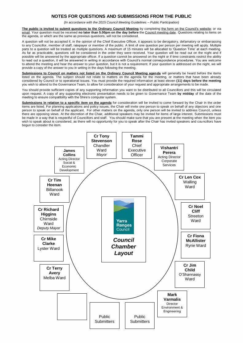
Cr Tony Stevenson Chandler
Ward Mayor
Tammi Rose Chief
Executive Officer
James Collins
Acting Director Social &
Economic Development
Vishantri Perera
Acting Director Corporate
Services
Cr Tim Heenan Billanook
Ward
Cr Len Cox Walling Ward
Cr Richard Higgins
Chirnside Ward
Deputy Mayor
Cr Noel Cliff
Streeton Ward
Cr Mike Clarke
Lyster Ward
Cr Fiona McAllister
Ryrie Ward
Cr Terry Avery
Melba Ward
Cr Jim Child
O’Shannassy Ward
Mark
Varmalis Director
Environment &
Engineering
Public Submitters
Public Submitters
Council Chamber Layout
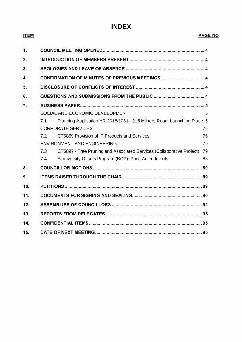
INDEX
ITEM PAGE NO
1. COUNCIL MEETING OPENED ................................................................................ 4
2. INTRODUCTION OF MEMBERS PRESENT ........................................................... 4
3. APOLOGIES AND LEAVE OF ABSENCE .............................................................. 4
4. CONFIRMATION OF MINUTES OF PREVIOUS MEETINGS .................................. 4
5. DISCLOSURE OF CONFLICTS OF INTEREST ...................................................... 4
6. QUESTIONS AND SUBMISSIONS FROM THE PUBLIC ........................................ 4
7. BUSINESS PAPER .................................................................................................. 5
SOCIAL AND ECONOMIC DEVELOPMENT 5
7.1 Planning Application YR-2018/1031 - 215 Milners Road, Launching Place 5
CORPORATE SERVICES 76
7.2 CT5869 Provision of IT Products and Services 76
ENVIRONMENT AND ENGINEERING 79
7.3 CT5897 - Tree Pruning and Associated Services (Collaborative Project) 79
7.4 Biodiversity Offsets Program (BOP): Price Amendments 83
8. COUNCILLOR MOTIONS ...................................................................................... 89
9. ITEMS RAISED THROUGH THE CHAIR ............................................................... 89
10. PETITIONS ............................................................................................................ 89
11. DOCUMENTS FOR SIGNING AND SEALING....................................................... 90
12. ASSEMBLIES OF COUNCILLORS ....................................................................... 91
13. REPORTS FROM DELEGATES ............................................................................ 95
14. CONFIDENTIAL ITEMS ......................................................................................... 95
15. DATE OF NEXT MEETING .................................................................................... 95
YARRA RANGES COUNCIL MEETING AGENDA - 13/08/2019 4
YARRA RANGES COUNCIL AGENDA FOR THE 499TH ORDINARY COUNCIL MEETING TO BE HELD ON TUESDAY 13 AUGUST 2019 COMMENCING AT 7.00PM IN COUNCIL CHAMBER, CIVIC CENTRE, ANDERSON STREET, LILYDALE
1. COUNCIL MEETING OPENED
2. INTRODUCTION OF MEMBERS PRESENT
3. APOLOGIES AND LEAVE OF ABSENCE
An apology for this meeting has been received from Councillor Mike Clarke.
4. CONFIRMATION OF MINUTES OF PREVIOUS MEETINGS
RECOMMENDATION
That the Minutes of the Ordinary Council Meeting held 23 July 2019, as circulated, be confirmed.
5. DISCLOSURE OF CONFLICTS OF INTEREST
In accordance with section 79 of the Local Government Act 1989.
6. QUESTIONS AND SUBMISSIONS FROM THE PUBLIC
In accordance with Clause 83 of Meeting Procedures and Use of Common Seal Local Law 2015
There were no Questions to Council or Submissions from the Public received prior to the Agenda being printed.
ITEM 7.1
YARRA RANGES COUNCIL MEETING AGENDA - 13/08/2019 5
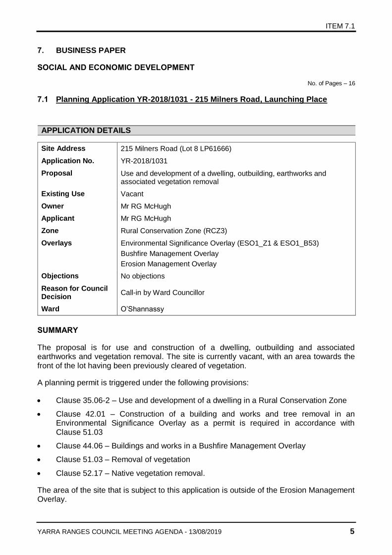
7. BUSINESS PAPER
SOCIAL AND ECONOMIC DEVELOPMENT
No. of Pages – 16
7.1 Planning Application YR-2018/1031 - 215 Milners Road, Launching Place
APPLICATION DETAILS
Site Address 215 Milners Road (Lot 8 LP61666)
Application No. YR-2018/1031
Proposal Use and development of a dwelling, outbuilding, earthworks and associated vegetation removal
Existing Use Vacant
Owner Mr RG McHugh
Applicant Mr RG McHugh
Zone Rural Conservation Zone (RCZ3)
Overlays Environmental Significance Overlay (ESO1_Z1 & ESO1_B53)
Bushfire Management Overlay
Erosion Management Overlay
Objections No objections
Reason for Council Decision
Call-in by Ward Councillor
Ward O’Shannassy
SUMMARY
The proposal is for use and construction of a dwelling, outbuilding and associated earthworks and vegetation removal. The site is currently vacant, with an area towards the front of the lot having been previously cleared of vegetation.
A planning permit is triggered under the following provisions:
Clause 35.06-2 – Use and development of a dwelling in a Rural Conservation Zone
Clause 42.01 – Construction of a building and works and tree removal in an Environmental Significance Overlay as a permit is required in accordance with Clause 51.03
Clause 44.06 – Buildings and works in a Bushfire Management Overlay
Clause 51.03 – Removal of vegetation
Clause 52.17 – Native vegetation removal.
The area of the site that is subject to this application is outside of the Erosion Management Overlay.
ITEM 7.1 (Cont’d)
YARRA RANGES COUNCIL MEETING AGENDA - 13/08/2019 6
The application has been advertised and no objection has been received.
It is considered that the use and development of the site for dwelling purposes is unsatisfactory when assessed against the relevant policies and provisions of the Yarra Ranges Planning Scheme. The location of the dwelling in an area of significant vegetation with significant bushfire risk will require substantial clearance of vegetation to achieve appropriate clearance defendable space distances required by CFA. This will require clearance of most of the vegetation on the site within the defendable space which is inconsistent with the purpose of the RCZ which is to protect the biodiversity of the area.
The proposal is also inconsistent with the decision guidelines of the RCZ, BMO and the state and local policies on rural residential development in a Bushfire Management Overlay. On this basis, the application is recommended for refusal.
RECOMMENDATION
That Council resolve to refuse Planning Application YR-2018/1031 for use and development of a dwelling and outbuilding, earthworks and associated vegetation removal at 215 Milners Road, Launching Place and issue a Notice of Refusal subject to the grounds in Attachment 1 to the report.
DISCLOSURE OF CONFLICTS OF
The author of this report declares no conflict of interest when assessing this application.
SITE LOCATION AND DESCRIPTION
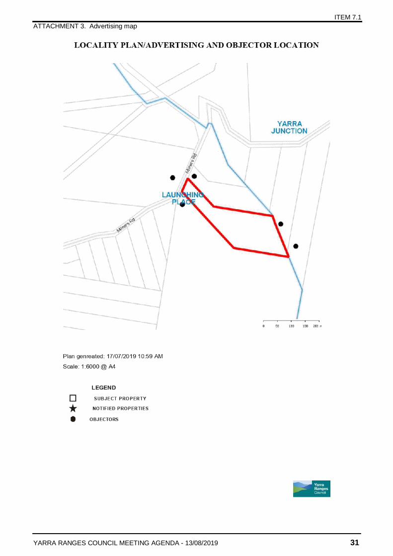
The subject site is described on title as Lot 8 on LP61666 on the submitted Register Search Statement Volume 08539 Folio 156.
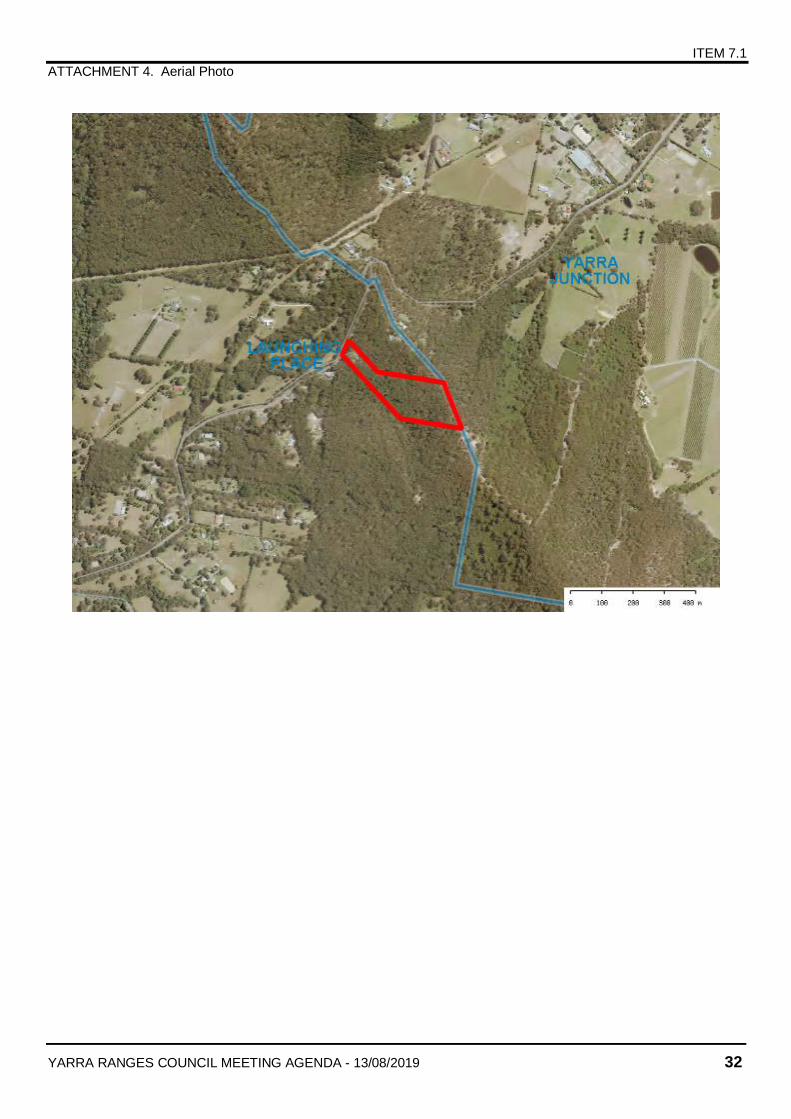
The subject site is located on the east side of Milners Road, Launching Place. The subject site is an irregular shaped block with a street frontage of 50.29 metres and a depth of 274 metres with a total site area of 3.745 hectares.
In terms of topography, the land falls in west to east direction for up to 6 metres to the rear of the site.
The site is currently undeveloped, but extensive earthworks and tree removal have occurred in the proposed development location.
The site is located within the Southern Fall Bioregion and the mapping of the Department of Sustainability and Environment (DSE) indicates the vegetation to be Lowland Forest Ecological Vegetation Class (EVC 16) and Damp Forest Ecological Vegetation Class (EVC 29). Both conservation statuses are of the ‘Least Concern’ within the Bioregion.
In terms of flora, the site is noted as containing one threatened flora species, the Wiry Bossiaea. The presence of this species on the site increases the conservation significance of the native vegetation to High Conservation Significance.
ITEM 7.1 (Cont’d)
YARRA RANGES COUNCIL MEETING AGENDA - 13/08/2019 7
The site contains vegetation that is categorised as ‘remnant patch’ vegetation under DEPI 2013a. Whilst the understorey is disturbed in much of area proposed for development, the vegetation would still classify as remnant patch based on canopy cover thresholds.
The site is not affected by a restrictive covenant.
SURROUNDING AREA
The subject site is located within a forested region southeast of the Yarra Junction Township. A mountainous ridge including Milner’s Hill runs northwest to southeast through the region and the subject site is on the edge of that ridge. Properties surrounding the subject site to the north, east and south are all heavily vegetated, with properties to the west side of Milners Road including areas of forest and cleared pastures.
A vacant forested land is located to the north. The property is known as 175 Milners Road with an area of approximately 4ha.
To the south, the subject land adjoins 221-225 Milners Road. This property contains a dwelling and outbuilding on number 225 and vacant forested land on number 221. The lots are in common ownership, with the forested land being required to be managed to offset vegetation loss that was incurred as part of the development of the land for a dwelling and associated defendable space. The combined land area is approximately 26.8ha.
Properties further southwest along Milners Road each contain a dwelling in a cleared area, with large areas of native forest. Properties to the northeast along Milners Road closer to Yarra Junction Township are generally cleared pasture, and each contains a dwelling.
HISTORY
Application Number and
Decision Date
YR-2009/1589 - Use and development for a dwelling, outbuilding, water tanks and associated earthworks and vegetation removal – refused on 27/1/12
YR-2016/1287 - Use and construction of a single dwelling and removal of vegetation – refused on 24/11/17
VCAT History None
Other History Alleged vegetation clearance by a previous land owner
PROPOSAL
The application seeks permission for the use and development of a dwelling, outbuilding, earthworks and associated vegetation removal on the subject land.
ITEM 7.1 (Cont’d)
YARRA RANGES COUNCIL MEETING AGENDA - 13/08/2019 8
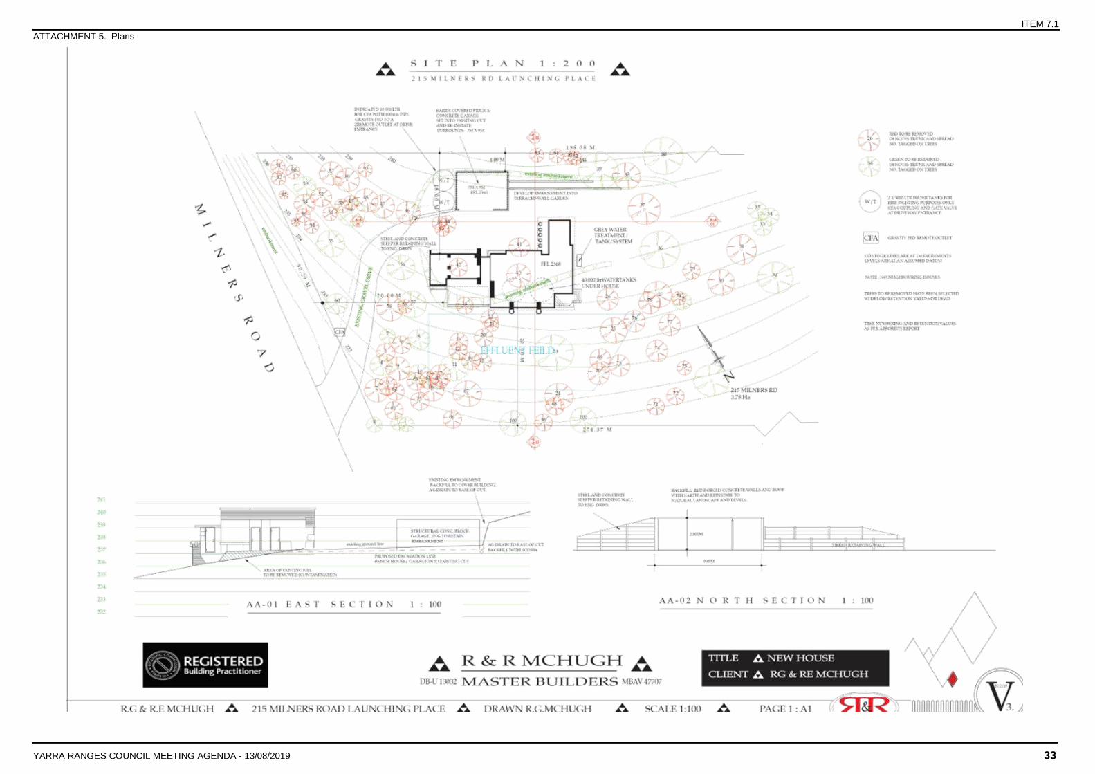
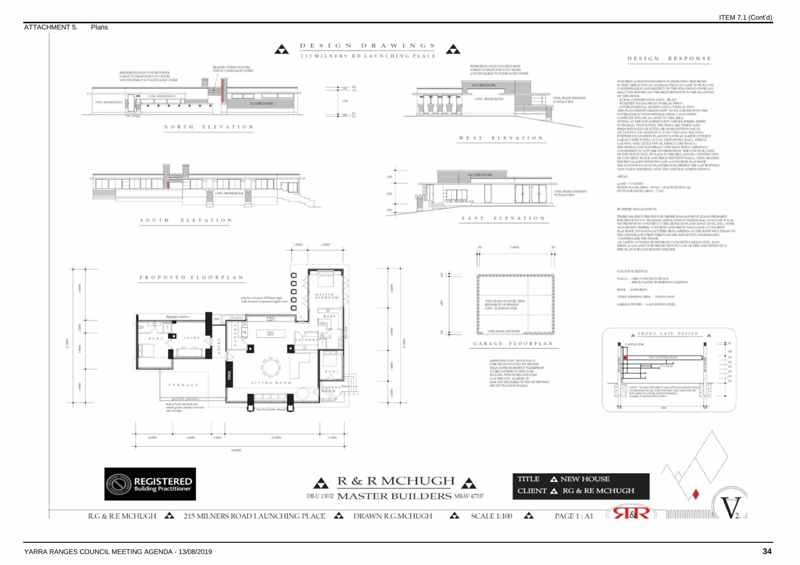
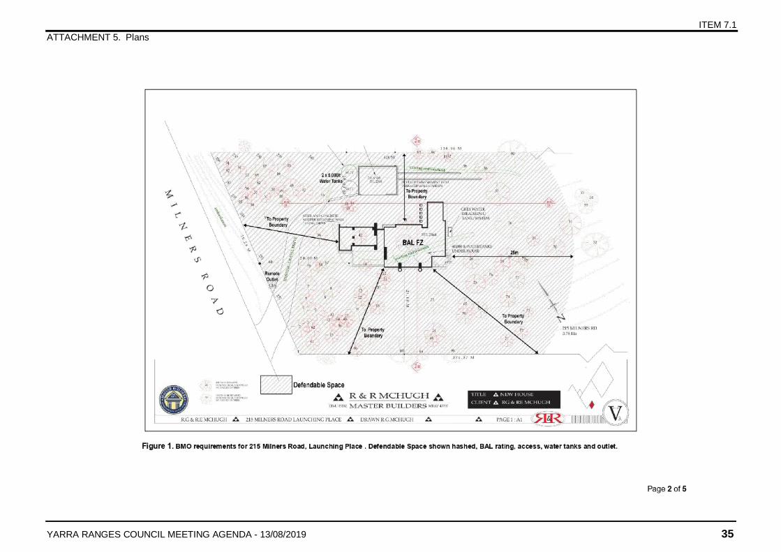
The dwelling would be setback approximately 19.3 metres from the front boundary, 18 metres from the north boundary and 20 metres from the south boundary. It would be single storey with a maximum height of 4.7 metres and would be constructed of raw concrete blocks, brown bricks and an Indian Red Colorbond roof.
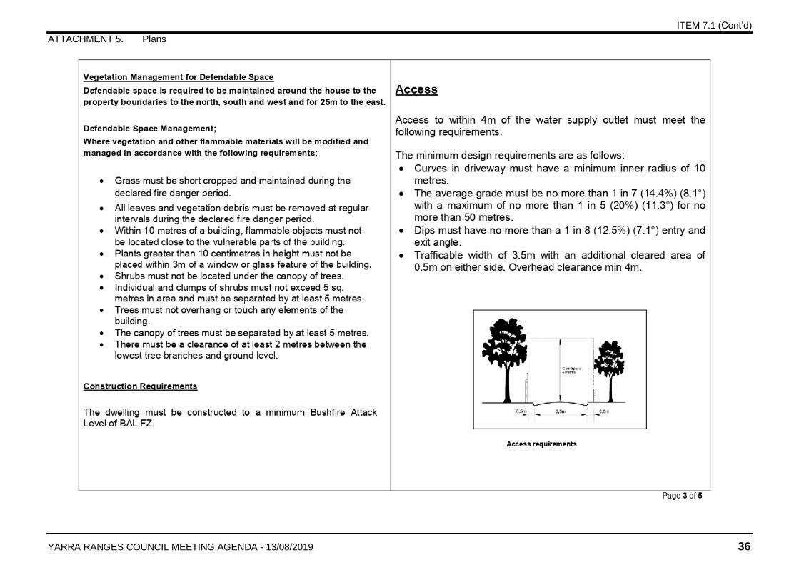
The dwelling is proposed to be constructed to the BAL-FZ standard, with defendable space to BAL-29 distances to the rear of the dwelling and to the property boundary in all other directions.
A detached outbuilding is also proposed, which would be setback approximately 14.7 metres from the front boundary and approximately 4 metres from the north boundary. It would be excavated into an embankment located towards the north side of the property, with associated retaining walls constructed to support the embankment. The outbuilding would be constructed in materials to match the dwelling.
This proposal includes removal of trees #2-5, 7-10, 12-22, 24-27, 29-31, 36-38, 40-54, 56, 58, 59, 61-79, 81-85, 87-97 and 99. Trees #2, 10, 21, 40-44, 56 and 81 are dead and do not need a permit.
The site plan submitted with the application show different tree retention/ tree removal compared to the submitted bushfire management plan and arborist report. The tree removal proposed in the BMP and arborist reports are used for this assessment. An extract of the arborist report submitted with the application can be found at Attachment 7 for tree details.
PLANNING CONTROLS
Zoning: Clause 35.06 Rural Conservation Zone (RCZ3)
Overlay: Clause 42.01 Environmental Significance Overlay (ESO1_Z1 & B53)
Clause 44.06 Bushfire Management Overlay
Clause 44.01 Erosion Management Overlay
Planning Policy Framework: Clause 11 Settlement
Clause 12 Environmental & Landscape Values
Clause 13 Environmental Risks
Clause 14 Natural Resource Management
Clause 15 Built Environment & Heritage
Clause 16 Housing
Local Planning Policy: Clause 21.04 Land Use
Clause 21.06 Built form
Clause 21.07 Landscape
Clause 21.09 Environmental Hazards
Clause 22.05 Vegetation Protection
Clause 23 Operation of LPPF (Transitional)
Schedule to Clause 51.03: Applies
Other Requirements: Clause 52.17 Native Vegetation
Clause 53.02 Planning for Bushfire
ITEM 7.1 (Cont’d)
YARRA RANGES COUNCIL MEETING AGENDA - 13/08/2019 9
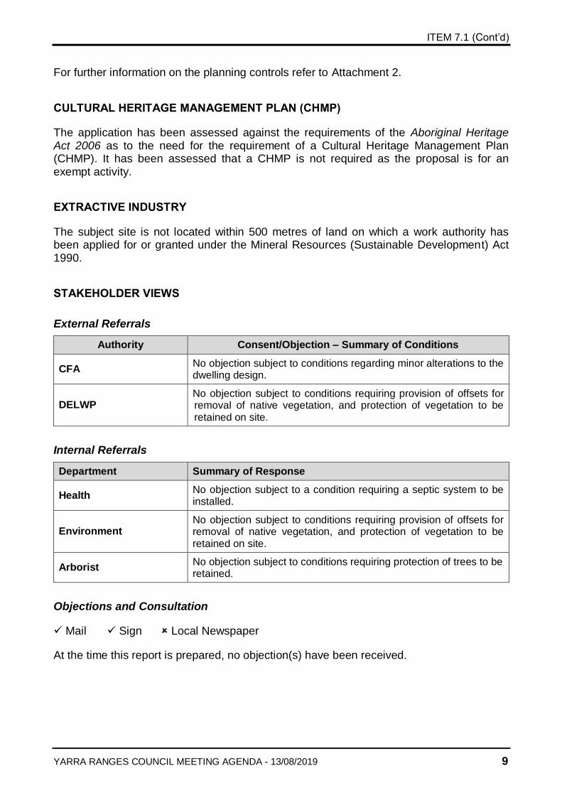
For further information on the planning controls refer to Attachment 2.
CULTURAL HERITAGE MANAGEMENT PLAN (CHMP)
The application has been assessed against the requirements of the Aboriginal Heritage Act 2006 as to the need for the requirement of a Cultural Heritage Management Plan (CHMP). It has been assessed that a CHMP is not required as the proposal is for an exempt activity.
EXTRACTIVE INDUSTRY
The subject site is not located within 500 metres of land on which a work authority has been applied for or granted under the Mineral Resources (Sustainable Development) Act 1990.
STAKEHOLDER VIEWS
External Referrals
Authority Consent/Objection – Summary of Conditions
CFA No objection subject to conditions regarding minor alterations to the dwelling design.
DELWP No objection subject to conditions requiring provision of offsets for removal of native vegetation, and protection of vegetation to be retained on site.
Internal Referrals
Department Summary of Response
Health No objection subject to a condition requiring a septic system to be installed.
Environment No objection subject to conditions requiring provision of offsets for removal of native vegetation, and protection of vegetation to be retained on site.
Arborist No objection subject to conditions requiring protection of trees to be retained.
Objections and Consultation
Mail Sign Local Newspaper
At the time this report is prepared, no objection(s) have been received.
ITEM 7.1 (Cont’d)
YARRA RANGES COUNCIL MEETING AGENDA - 13/08/2019 10
ASSESSMENT/ KEY ISSUES
The proposal has been assessed against the applicable Zone and Overlay provisions, the Planning Policy Framework (PPF), Particular Provisions and Decision Guidelines of the Planning Scheme and has been found to be inappropriate, especially in regards to risk to life from bushfire threat. These issues will be discussed in further detail below.
The planning issues associated with using and developing the subject site are challenging. This is evidenced by the two previous unsuccessful attempts to obtain a planning permit to construct a dwelling. The dense vegetation and the relatively isolated nature of the site, coupled with the matrix of planning controls and policies, call up a number of varied considerations that need to be satisfied.
In addition to the Rural Conservation Zone, the subject site is also located within the Environmental Significance Overlay (ESO1) and Bushfire Management Overlay. These layers of control, together with the Planning Policy Framework at Clauses 12 Environmental and Landscape values and Clause 13 Environmental Management and Risk all point to the need to protect human life from bushfire as well as to protect native vegetation for its ecological and landscape values. As described below, the application has failed to demonstrate how it protects human life from bushfire risk. Therefore, the application warrants a refusal.
Planning Policy - Bushfire
The overarching strategy of bushfire planning is to prioritise the protection of human life over other policy considerations in planning and decision-making in areas at risk from bushfire. Clause 13.02-1S (Environmental Risks) and Clause 21.09 (Environmental Hazards) state that in considering a decision, the Responsible Authority must prioritise the protection of human life over other policy considerations. This is to ensure that development occurs in low risk locations to protect human life and be able to implement bushfire protection measures without unacceptable biodiversity impacts where in areas of high biodiversity conservation value.
Recent updates to the Yarra Ranges Planning Scheme, including Clause 13.02 (Bushfire), Clause 44.06 (Bushfire Management Overlay) and Clause 53.02 (Bushfire Planning) place even greater emphasis on managing bushfire risk through stringent siting and design controls.
Amendment VC140 was introduced into the Scheme on 12 December 2017. Amendment VC140 amended the Planning Policy Framework (PPF) with respect to bushfire. There were no transitional provisions which mean that the permit application needs to be assessed against this new policy framework.
The new policy provisions include:
Give priority to the protection of human life by:
Prioritising the protection of human life over all other policy considerations
Directing population growth and development to low risk locations and ensuring the availability of, and safe access to, areas where human life can be better protected from the effects of bushfire
ITEM 7.1 (Cont’d)
YARRA RANGES COUNCIL MEETING AGENDA - 13/08/2019 11
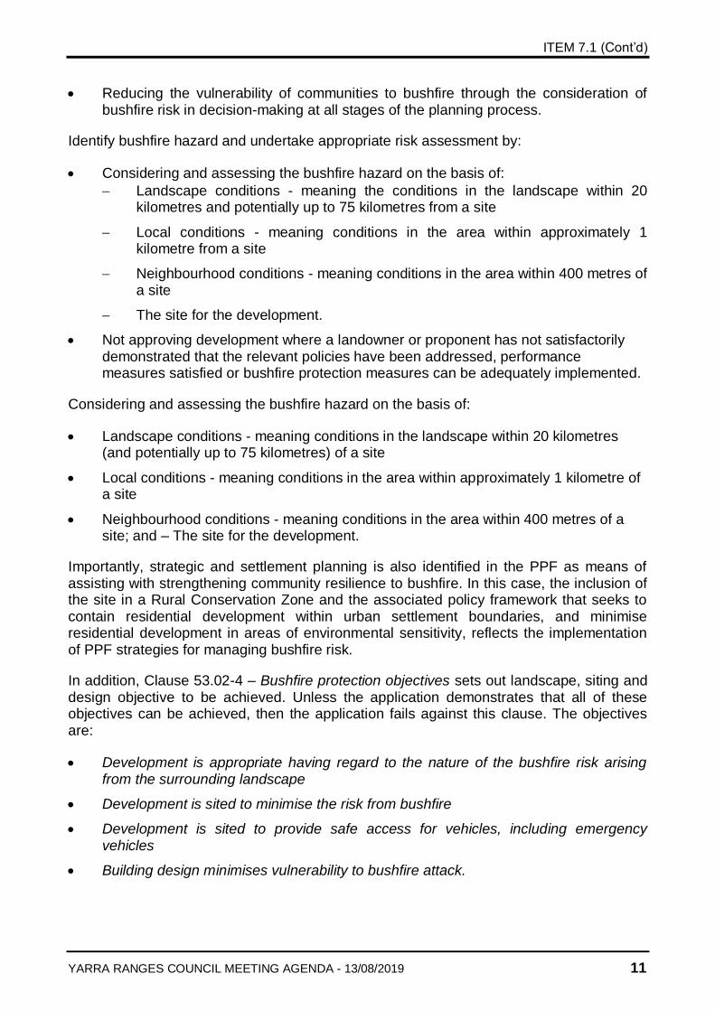
Reducing the vulnerability of communities to bushfire through the consideration of bushfire risk in decision-making at all stages of the planning process.
Identify bushfire hazard and undertake appropriate risk assessment by:
Considering and assessing the bushfire hazard on the basis of:
Landscape conditions - meaning the conditions in the landscape within 20 kilometres and potentially up to 75 kilometres from a site
Local conditions - meaning conditions in the area within approximately 1 kilometre from a site
Neighbourhood conditions - meaning conditions in the area within 400 metres of a site
The site for the development.
Not approving development where a landowner or proponent has not satisfactorily demonstrated that the relevant policies have been addressed, performance measures satisfied or bushfire protection measures can be adequately implemented.
Considering and assessing the bushfire hazard on the basis of:
Landscape conditions - meaning conditions in the landscape within 20 kilometres (and potentially up to 75 kilometres) of a site
Local conditions - meaning conditions in the area within approximately 1 kilometre of a site
Neighbourhood conditions - meaning conditions in the area within 400 metres of a site; and – The site for the development.
Importantly, strategic and settlement planning is also identified in the PPF as means of assisting with strengthening community resilience to bushfire. In this case, the inclusion of the site in a Rural Conservation Zone and the associated policy framework that seeks to contain residential development within urban settlement boundaries, and minimise residential development in areas of environmental sensitivity, reflects the implementation of PPF strategies for managing bushfire risk.
In addition, Clause 53.02-4 – Bushfire protection objectives sets out landscape, siting and design objective to be achieved. Unless the application demonstrates that all of these objectives can be achieved, then the application fails against this clause. The objectives are:
Development is appropriate having regard to the nature of the bushfire risk arising from the surrounding landscape
Development is sited to minimise the risk from bushfire
Development is sited to provide safe access for vehicles, including emergency vehicles
Building design minimises vulnerability to bushfire attack.
ITEM 7.1 (Cont’d)
YARRA RANGES COUNCIL MEETING AGENDA - 13/08/2019 12
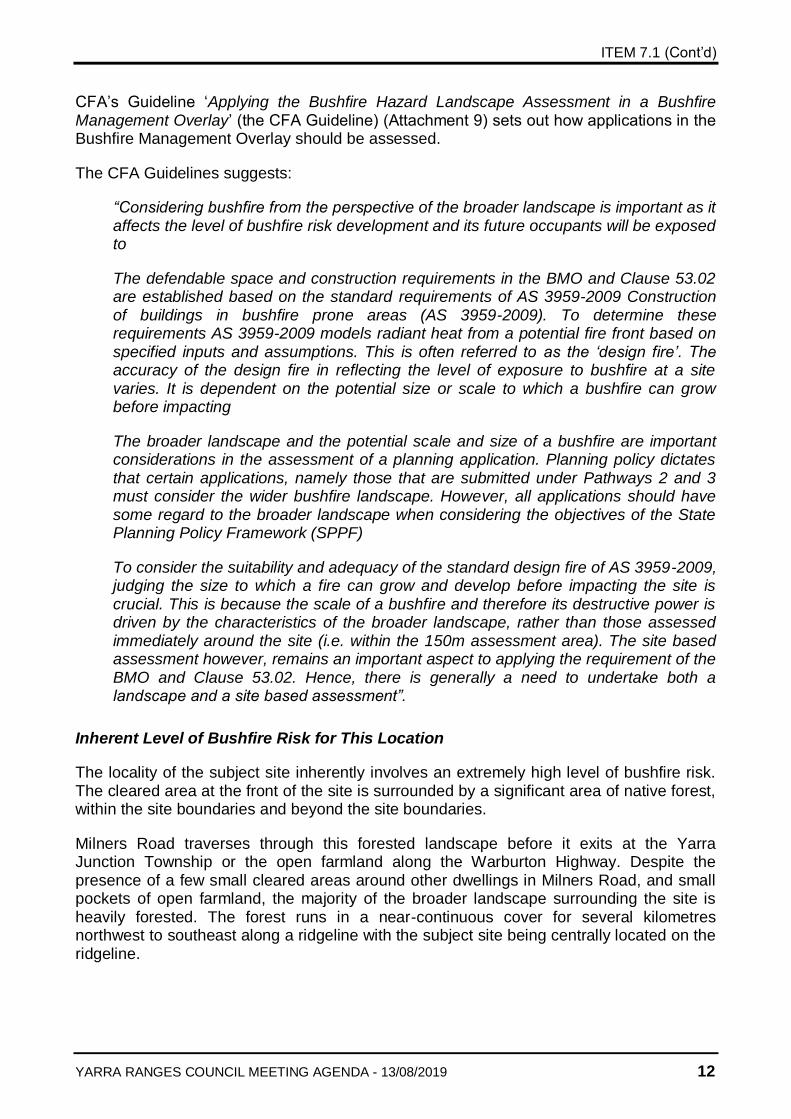
CFA’s Guideline ‘Applying the Bushfire Hazard Landscape Assessment in a Bushfire Management Overlay’ (the CFA Guideline) (Attachment 9) sets out how applications in the Bushfire Management Overlay should be assessed.
The CFA Guidelines suggests:
“Considering bushfire from the perspective of the broader landscape is important as it affects the level of bushfire risk development and its future occupants will be exposed to
The defendable space and construction requirements in the BMO and Clause 53.02 are established based on the standard requirements of AS 3959-2009 Construction of buildings in bushfire prone areas (AS 3959-2009). To determine these requirements AS 3959-2009 models radiant heat from a potential fire front based on specified inputs and assumptions. This is often referred to as the ‘design fire’. The accuracy of the design fire in reflecting the level of exposure to bushfire at a site varies. It is dependent on the potential size or scale to which a bushfire can grow before impacting
The broader landscape and the potential scale and size of a bushfire are important considerations in the assessment of a planning application. Planning policy dictates that certain applications, namely those that are submitted under Pathways 2 and 3 must consider the wider bushfire landscape. However, all applications should have some regard to the broader landscape when considering the objectives of the State Planning Policy Framework (SPPF)
To consider the suitability and adequacy of the standard design fire of AS 3959-2009, judging the size to which a fire can grow and develop before impacting the site is crucial. This is because the scale of a bushfire and therefore its destructive power is driven by the characteristics of the broader landscape, rather than those assessed immediately around the site (i.e. within the 150m assessment area). The site based assessment however, remains an important aspect to applying the requirement of the BMO and Clause 53.02. Hence, there is generally a need to undertake both a landscape and a site based assessment”.
Inherent Level of Bushfire Risk for This Location
The locality of the subject site inherently involves an extremely high level of bushfire risk. The cleared area at the front of the site is surrounded by a significant area of native forest, within the site boundaries and beyond the site boundaries.
Milners Road traverses through this forested landscape before it exits at the Yarra Junction Township or the open farmland along the Warburton Highway. Despite the presence of a few small cleared areas around other dwellings in Milners Road, and small pockets of open farmland, the majority of the broader landscape surrounding the site is heavily forested. The forest runs in a near-continuous cover for several kilometres northwest to southeast along a ridgeline with the subject site being centrally located on the ridgeline.
ITEM 7.1 (Cont’d)
YARRA RANGES COUNCIL MEETING AGENDA - 13/08/2019 13
The extent of forest cover on the subject site and in the broader landscape mean that there is a high level if fuel present that would increase the risk or intensity of bushfire. The near-continuous coverage would also lead to ‘fire runs’ where the spread of bushfire would occur more rapidly because of a lack of large breaks in the fuel.
The bushfire management plan identifies that there have been planned burns in the surrounding forest, carried out by CFA and DELWP. It also identifies that future planned burns are proposed by those organisations for fuel reduction. However, it is considered that the applicant cannot rely on future fuel reduction burns occurring. Any number of reasons might prevent or delay those planned burns from occurring, or a bushfire could occur prior to the planned burns taking place.
VCAT decisions such as O’Toole v Yarra Ranges SC [2019] VCAT 810 (Refer to attachment 10) also relied on other agencies for to manage firebreaks. This is not a satisfactory solution as there is no guarantee that these arrangements can be maintained in perpetuity.
This context makes a ‘stay and defend’ scenario more likely in the event of a fast moving bushfire, compared with a site that was either much closer to a township, or was surrounded by cleared land, rather than the occupant leaving before a bushfire comes. This indicates a much higher risk to human life than is acceptable.
In this case, the ability to mitigate the bushfire risk to an acceptable level from the landscape beyond the site is largely unachievable, and is limited to what can be provided on site through clearing of fuel loads from the defendable space as part of the proposed development. Council is to consider that the context of the area, both within the subject site and the surrounding area is heavily vegetated. The management of fuel within the surrounding forest areas is not possible for the owners/occupiers of the subject land, hence it is officer’s view that bushfire risk faced by this site is unmanageable and the use of land for a dwelling is unacceptable.
On-site Bushfire Risk Mitigation
In addition to the high level policy requirements and an assessment of the inherent bushfire risk in the broader landscape, an application for construction of a dwelling in the Bushfire Management Overlay must demonstrate compliance with Clause 53.02 – Bushfire Planning.
Clause 53.02 sets out a series of objectives that must be achieved. Approved Measures are specified and compliance with those Approved Measures is deemed to achieve those objectives. Where compliance with an Approved Measure cannot be achieved on the subject site, Clause 53.02 provides Alternative Measures. One of those Alternative Measures is an option for the applicant to demonstrate that the objective can be achieved without utilising any of the Approved Measures or specified Alternative Measures. The application has proposed to use an unspecified Alternative Measure for the construction standard and for the defendable space.
The bushfire management statement identified the site fell within the flame zone bushfire attack level (BAL-FZ). It is worth noting that in Clause 53.02, the maximum bushfire attack level (BAL) level permitted is BAL-40 as stated under Approved Measure 3.1. BAL-FZ is therefore clearly beyond those requirements. On a sliding scale BAL-FZ is the highest construction rating. The requirement of BAL-FZ indicates an extreme bushfire risk on the
ITEM 7.1 (Cont’d)
YARRA RANGES COUNCIL MEETING AGENDA - 13/08/2019 14
site and surrounding landscape, and the inability to manage vegetation to an acceptable level within a lower order (larger) defendable space area. BAL-FZ anticipates direct flame contact onto the dwelling, and mitigates risk to human life through a more stringent design requirement for the building.
BAL-FZ construction requires much higher construction standards to reduce the impact of radiant heat into the building. In this case, the application proposes:
Concrete slab floor
5" Concrete slab, flat roof
Full masonry walls
No fascia, eaves, flashing or capping on roof
Roof screeded into centre so water will flow through four drainage points in the middle of the roof, into water tanks under the house
Pluggable drainage points so water can be pumped onto the roof to create a water filled area (2-6Omm deep) to provide the home with an ember shield
Steel-framed, double glazed windows and doors
At a minimum windows will be 800mm off the floor
On the northern wall, the kitchen window is ~ 1000mm off the floor, with the study and bathroom windows on western wing being ~150Omm off the floor. These windows will be 500mm high, minimising exposure to the north.
Standard BAL-29 defendable space would require vegetation management for a distance of 25 metres in all directions around the dwelling. This cannot be achieved to the north, south or west of the dwelling on this site due to the siting of the dwelling at the narrowest part of the site and within close proximity to the front boundary. The application therefore proposes modified BAL-29 defendable space, with dimensions 25 metre to the rear of the dwelling and to the property boundary in all other directions. Defendable space is therefore much smaller than the Clause 53.02 would require as an Approve Measure.
It is considered that the proposal for creation of a modified BAL-29 defendable space and a BAL-FZ construction rating does not produce an acceptable outcome in regards to bushfire risk and the protection of human life. They only address bushfire risk mitigation on the site itself (and only for a small part of the site), and do not demonstrate how the risk in the broader landscape has been reduced.
There is a combination of elements that together lead to the conclusion that the proposal is not acceptable in regards to bushfire risk. Instead, the use and development of a new dwelling in an area of such high risk would increase the risk to human life for future residents, which is contrary to the outcomes sought by the planning scheme.
Although CFA has given a conditional consent for the construction of a dwelling on the subject site, an assessment of the planning policy has demonstrated that the risk to human life has not been met and this proposal falls well short of the high bar now in place in areas of high bushfire risk. Locating a dwelling on this site would be contrary to the principle in clause 13.05 that human life is paramount.
ITEM 7.1 (Cont’d)
YARRA RANGES COUNCIL MEETING AGENDA - 13/08/2019 15
The CFA had previously also supported a dwelling at 1 Highview Road, Ferny Creek in Adamson v Yarra Ranges SC [2013] where VCAT had not supported CFA recommendation that the land within the defendable space required would be managed appropriately to meet the bushfire provisions. To permit the construction of a dwelling in a context that the occupants will not be able to manage bushfire risk due to the presence fuel load in surrounding forest is not considered to be an appropriate decision, especially when a BAL-FZ construction exceeds that permitted under the Planning Scheme. Furthermore, a decision allowing the construction of a dwelling on this site will expose Council to a high level of risk should any human life be at threat in a bushfire event.
CFA’s Response
As a permit is triggered under the Bushfire Management Overlay, the application was referred to the Country Fire Authority (CFA) under section 55 of the Act, who recommended conditional consent to the granting of the planning permit based on water supply, vegetation management and buildings and works requirements being met. In addition, CFA requires amended plans to widen the access way at the front gate to 3.5 metres, and to remove all planter boxes from around the dwelling.
CFA’s consent is based upon what they consider to be the technical merits of the building itself. In their referral comments, they rely on ‘unspecified methods’. Those ‘unspecified methods’ relate to the assessment against the requirements of Clause 53.02 – where an Approved Measure cannot be met, an Alternative Measure may be considered. The clause lists various alternative measures, but also provides for solutions beyond those listed alternatives (unspecified methods) to meet the objectives. CFA consent is based upon the unspecified method of the combination of construction of the dwelling to BAL-FZ standard, as well as modified BAL-29 defendable space.
CFA’s position to support this application was not made at a local level, it was a decision made by their headquarters, based on discussions between various officers. They ended up agreeing that the site is not low risk, but is “not the worst they’ve ever seen”.
General principles used when assessing bushfire risk mitigation are a balance between BAL construction methods and defendable space. BAL-29 construction and defendable space is considered by CFA to be a “sweet spot” – it balances construction standards and defendable space distances.
For the subject site BAL-29 construction and defendable space could be achieved if the dwelling was to be located further into the site. However, CFA does not support that because the driveway would longer, steeper and traversing through forest, and the bushfire risk to the dwelling would come from all directions.
CFA supports the current dwelling location with BAL-FZ construction and BAL-29 defendable space. BAL-29 defendable space is the “unspecified methods” referred to in their referral comments. Bushfire risk is highest from the southwest and this is where defendable space is the maximum distance. Bushfire risk from other directions is considered less by CFA and they have accepted smaller defendable space in those directions.
In CFA’s opinion, the applicant has maximised what they can implement. The mitigating factors for this proposal are:
ITEM 7.1 (Cont’d)
YARRA RANGES COUNCIL MEETING AGENDA - 13/08/2019 16
Areas of farmland to the west and defendable space around existing dwellings in Milners Road to the southwest break up the continuous forest and reduce the bushfire risk from the broader landscape
Vegetation to the east is upslope from the dwelling, posing less of a risk than if it were downslope
BAL-29 defendable space around the proposed dwelling is fully achieved to the south
The dwelling is not proposed at the top of the hill (where the fire behaviour would be most severe).
Despite CFA’s support, and the application ‘ticking the box’ in regard to a Clause 53.02 assessment, it is considered that the application cannot be supported on policy grounds. The proposal does not satisfactorily address the provisions of Clauses 13.02 (Bushfire), 44.06 (Bushfire Management Overlay) and Clause 53.02 (Planning for Bushfire). The proposed development of land fails to prioritise the protection of human life and it fails to demonstrate that the risk to life and property from bushfire risk.
The proposal also fails to demonstrate the bushfire risk to the development from the landscape beyond the site can be mitigated to an acceptable level. Hence, the proposal is contrary to the fire protection objectives of the Bushfire Management Overlay, and warrants refusal.
Relevant Case Law
The Victorian Civil and Administrative Tribunal (VCAT) has dealt with the question of bushfire management and bushfire risk on a number of occasions.
The most recent case of relevance is Johnston v Yarra Ranges SC [2019] was decided on 1 August 2019. That case was a ‘conditions appeal’ relating to the distance of defendable space provided around a dwelling to be constructed in the Bushfire Management Overlay at 16 Glenview Road, Monbulk. Member Martin made the following comments:
46 “In the context of the 173 deaths experienced about 10 years ago with the Black Saturday bushfires, a key purpose of Clause 53.02 is “To ensure the development of land prioritises the protection of human life and strengthens community resilience to bushfire”
50 “For the following two reasons, I find the position of Council/CFA more persuasive. First, I find that this Table 2 information needs to be utilised in a contextual manner, with a healthy dollop of common sense, rather than applied in a slavish manner. Table 2 [in Clause 53.02] is a generic guide, and needs to be read with regard to the overriding BMO and Clause 53.02 purposes at play, notably the prioritising of the protection of human life”
51 “Second, I have already gone to some trouble to set out above the various site-specific reasons, for this particular land, why I consider a dwelling setback of 36 metres from the SW boundary to involve unacceptable bushfire risks. Where there is a tension between the two, I consider that a well informed and sensible site-specific bushfire risk assessment of the subject land and the contentious proposal trumps a simplistic application of Table 2”
ITEM 7.1 (Cont’d)
YARRA RANGES COUNCIL MEETING AGENDA - 13/08/2019 17
58 “In conclusion, the relevant case law is telling us that with development proposals in bushfire prone areas:
• the proposal does not need to be shown to be bushfire risk-free; but
• the bar is set at a very high level, in terms of the permit applicant needing to demonstrate that the proposal does not throw up any unacceptable bushfire risk (notably in relation to human life)”
Adamson v Yarra Ranges SC [2013] was decided on 3 April 2013, which upheld Council’s refusal of a permit for use and construction of a dwelling in the Bushfire Management Overlay at 1 Highview Road, Ferny Creek. Member Rundell stated:
43 “Hence, I have to conclude that the review site is unsuitable for a dwelling because it cannot provide the necessary defendable space within its own boundaries. Without that arrangement, this proposal falls well short of the high bar now in place in areas of high bushfire risk. I find that locating a dwelling on this site would be contrary to the principle in clause 13.05 that human life is paramount. This proposal places people in high danger, without appropriate protection, and I cannot support it
45 I think that the precautionary principle should be used in cases such as this. Human behaviour is uncertain (eg. commitment to ongoing maintenance), fire science is uncertain and the risk is exceptionally high (people die, property is destroyed and the environment is damaged for years)
46 I consider it appropriate that decision maker’s exercise considerable caution and to press the “go” button only when satisfied that it is highly likely that people and property will be able to survive the worst expected conditions. Policy suggests that without that comfort, it is foolish to allow development such as this”
Use of land for a dwelling
Residential land use is not written into the purposes of the Rural Conservation Zone (RCZ) although it is accepted that residential activities abound in the green wedge areas. Dwellings within green wedge areas have traditionally been considered a secondary land use, designed to support on-going environmental protection. The Planning Scheme requires the use of a property within RCZ for the purpose of a dwelling to be carefully balanced with the needs of the rural areas to be maintained for the native environment and vegetation protection.
Despite the lack of residential purpose in the Green Wedge Zone, there are conditions required to be met in order to establish a dwelling within this zone.
The provisions of the Rural Conservation Zone provide some basic tests which a lot to be used for a dwelling must meet. It is considered that these basic tests are met as follows:
• Access to the dwelling must be provided via an all-weather road with dimensions adequate to accommodate emergency vehicles – Milners Road is an all-weather road of adequate dimensions
ITEM 7.1 (Cont’d)
YARRA RANGES COUNCIL MEETING AGENDA - 13/08/2019 18
• The dwelling must be connected to a reticulated sewerage system or if not available, the waste water must be treated and retained on-site in accordance with the State Environment Protection Policy (Waters of Victoria) under the Environment Protection Act 1970 – the site is not connected to reticulated sewerage however can attenuate all effluent on site. Council’s Environmental Health Unit have requested appropriate conditions to be included in any permit issued to ensure this is done in accordance with EPA requirements
• The dwelling must be connected to a reticulated potable water supply or have an alternative potable water supply with adequate storage for domestic use as well as for fire fighting purposes – water is available via a 10,000 litre water tank that is specified in the submitted Bushfire Management Plan
• The dwelling must be connected to a reticulated electricity supply or have an alternative energy source – electricity is available via Milners Road.
Whilst the proposed dwelling meets these requirements, they do not outweigh the risk to life from bushfire threats (which are assessed below), environmental impacts of the extensive tree removal required to accommodate the dwelling, shed and bushfire defendable space requirements. Besides, meeting the zone conditions does not automatically warrant a permit.
Planning Practice Note 42 – Applying the Rural Zones (June 2015 PPN42) (Attachment 8) sets out that land uses in the RCZ are subordinate to the environmental values of the land, and that land use and development should be controlled to protect and conserve the identified environmental qualities of the land. As such, there is an expectation that a proposal will only be supported if it conserves the environmental values of the land in an on-going way, and that the land has the capacity to accommodate the use and development.
The RCZ has been applied in areas where the primary objective is the protection of environmental features such as native vegetation. The subject site is located in Schedule 3 to the RCZ which has the following conservation values:
To retain and protect the scenic landscapes, rural character and special environmental features of the Shire
To provide long term protection of the environmental and conservation values of those areas of private rural land which contain remnant bushland, wetlands and areas of landscape significance.
Clause 52.17 – Native Vegetation
Biodiversity Legislation and Government Policy
The implications for the proposal are assessed in relation to relevant biodiversity legislation and policy and the Yarra Ranges Planning Scheme (Planning and Environment Act 1987 S60 (1) a, b and e) that Council should consider.
The proposal will incur the loss of 0.236Ha patch vegetation, to allow for the construction footprint and establishment of defendable space around the dwelling. This consists of 73 native canopy trees (8 of which are large trees), and 10 trees which are dead. No permit is required for dead trees under the schedule to Clause 51.03.
ITEM 7.1 (Cont’d)
YARRA RANGES COUNCIL MEETING AGENDA - 13/08/2019 19
The submitted arborist report has demonstrated that the majority of trees to be removed are relatively small in comparison to trees being retained, and/or are in poor condition. The trees being retained have been carefully selected so that the largest and healthiest trees are being retained. This is positive in terms of the contribution to the streetscape and landscape impact of the development. Retaining the largest trees provides scattered tree coverage within the frontage setback similar to nearby developments, which is encouraged. It also provides habitat for local birds and insects.
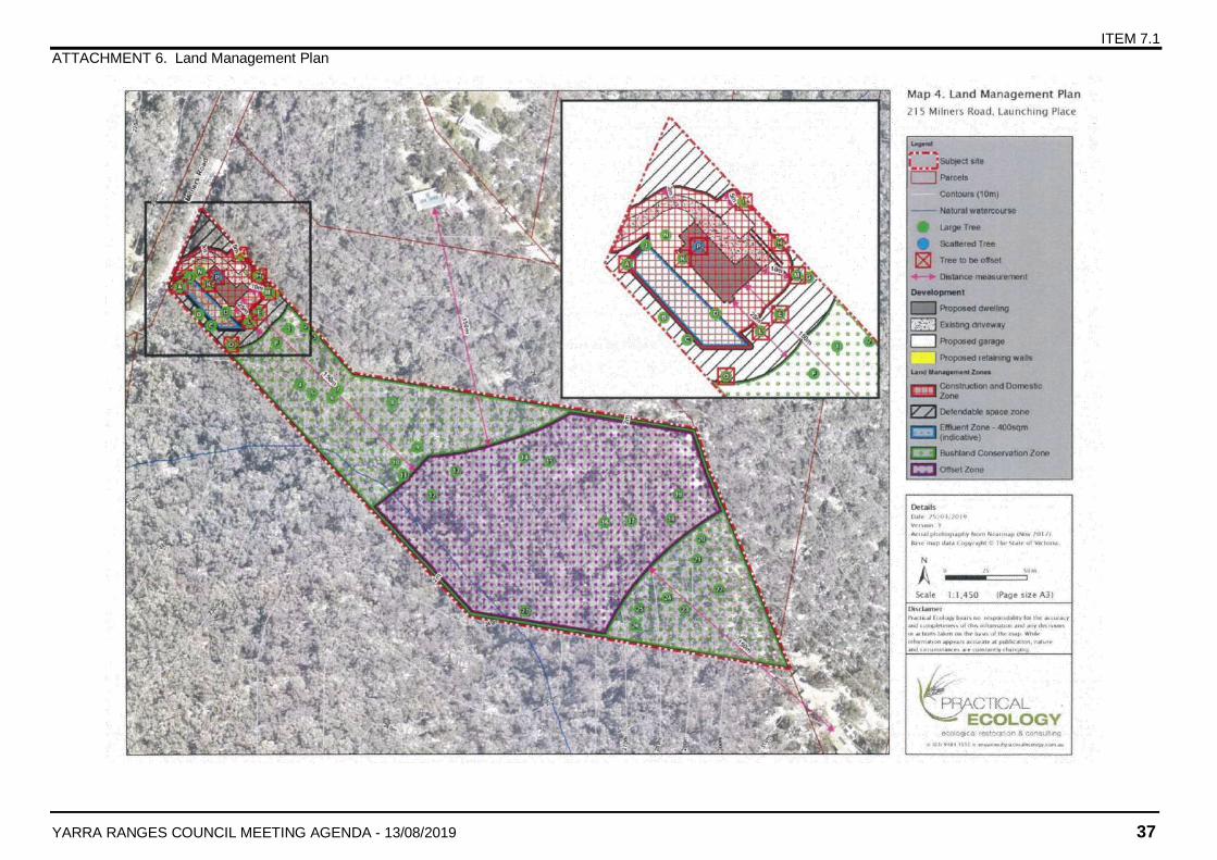
The proposed development will result in a significant impact on native vegetation within areas defined as the Construction and Domestic Zone (CDZ) and the Defendable Space Zone (DSZ) (see Attachment 5 to this report). It is proposed that the development infrastructure footprint, including the dwelling, outbuilding, driveway, water tanks, earthworks, all construction impacts and all effluent management impacts, will be contained within the CDZ. Vegetation management for defendable space will be contained within the DSZ. All vegetation is considered lost within these two zones, adding up to a total removal of a patch of 0.263 Ha, with the exception of 6 Large Trees, which are proposed to be retained. The 6 trees to be retained, including Tree #6, fall within the CDZ and #23, 57, 80, 98 and 100 are within the DSZ. This retention has the following implications for the offset calculations for the clearing:
8 of the Large Trees which fall within the CDZ and DSZ will be removed and are considered removed for the purpose of offset calculations; but
The entire 0.263 Ha area of the CDZ and DSZ is included as a patch in the offset calculations for the development, the 6 Large Trees proposed for retention are not included in the Large Tree Attribute for the offset (i.e. the offset is calculated to require only 8 Large trees rather than the 14 that would be required if the 6 Large Trees were not being retained).
Retention of 6 Large Trees within the CDZ and DSZ maintains some of the biodiversity values associated with those large trees and would provide some natural habitat within the developed area.
On balance, if a permit is granted, it is considered that these trees should be retained and allowed to be excluded from the Large Tree Attribute for the offset but they should be clearly identified in a Land Management Plan registered on tile. This plan should detail how these trees are to be protected from damage during construction and ongoing use of the CDZ and DSZ. The plan should also require that if these trees die or are removed within 10 years of works commencing on the site, they must be offset as if part of the initial development proposal. If a permit issues, a condition can require a detailed land management plan to be prepared.
It is considered that the proposal satisfactorily minimises removal of native vegetation and the impacts on biodiversity. The location of the dwelling and associated infrastructure close to Milners Road allows for use of the existing access track as a driveway and places the development footprint over that area of the property that has already been disturbed by unpermitted clearing, thus minimising further vegetation removal and leaving the majority of the property, which lies to the east of the development footprint, undisturbed.
ITEM 7.1 (Cont’d)
YARRA RANGES COUNCIL MEETING AGENDA - 13/08/2019 20
Assessment of current proposal against previous reasons for refusal
The main ground of refusal of the previous application was centred on lack of information. That application failed to identify the extent of native vegetation that would need to be removed for defendable space. The current application has addressed this issue by providing comprehensive information about the native vegetation impacts.
The applicant’s attempt to address the previous grounds of refusal includes provision of an onsite offset and establishment of the remaining undeveloped balance of the property as Bushland Conservation Zone. In addition, the location of dwelling within the previously disturbed section of the property and building to BAL-FZ construction standard to minimise defendable space requirements are the most important measures taken in revised application to address the previous reasons for refusal.
However, the identification and minimisation of native vegetation impacts does not take away from the risk to human life from bushfire. Risk to life from bushfire was another key refusal ground of the previous application. The current application has not demonstrated how the proposal mitigates risk to human life from bushfire, beyond using the alternative Measure of a combined BAL-FZ construction and modified BAL-29 defendable space.
It is therefore considered that the application has not fully addressed the previous refusal grounds, and the refusal grounds relating to risk to human life from bushfire should still stand.
CONCLUSION
The use and development application has been assessed in accordance with Section 60(1) of ‘The Act’ and all relevant instruments and policies. The proposal is considered to be inconsistent with the objectives of planning policy framework and the relevant zone and overlay provisions of the Planning Scheme. As such, refusal is recommended.
ATTACHMENTS
1 Refusal Grounds⇩
2 Planning Scheme Requirements⇩
3 Advertising map⇩
4 Aerial Photo⇩
5 Plans⇩
6 Land Management Plan⇩
7 List of Vegetation on Site⇩
8 Practice Note - Applying the Rural Zones⇩
9 CFA Guideline for Assessing the BMO⇩
10 O'Toole v Yarra Ranges SC 2018⇩

ITEM 7.1
ATTACHMENT 1. Refusal Grounds
YARRA RANGES COUNCIL MEETING AGENDA - 13/08/2019 21
REFUSAL GROUNDS
Application YR-2018/1031
Address of the land 215 Milners Road (Lot 8 LP61666), Launching Place
Proposal Use and development of a dwelling and outbuilding, earthworks and associated vegetation removal
1. The use and development of a dwelling in a high bushfire risk area is contrary to the planning
scheme requirements to protect human life from bushfire, including Clause 13.02-1S and the
Bushfire Management Overlay.
2. The proposal does not satisfactorily address the provisions of Clauses 13.02 (Bushfire),
44.06 (Bushfire Management Overlay) and Clause 53.02 (Planning for Bushfire) as it does
not result in the development of land that prioritises the protection of human life and it does
not demonstrate that the risk to life and property from bushfire can be reduced to an
acceptable level and managed in an acceptable state. In particular, the proposal cannot
demonstrate the bushfire risk to the development from the landscape beyond the site can be
mitigated to an acceptable level. The vegetation around the dwelling cannot be appropriately
managed to reduce the potential fire intensity in the vicinity of buildings, which is contrary to
the fire protection objectives of the Bushfire Management Overlay.
ITEM 7.1
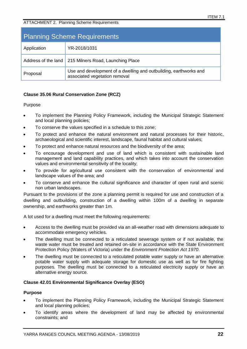
ATTACHMENT 2. Planning Scheme Requirements
YARRA RANGES COUNCIL MEETING AGENDA - 13/08/2019 22
Planning Scheme Requirements
Application YR-2018/1031
Address of the land 215 Milners Road, Launching Place
Proposal Use and development of a dwelling and outbuilding, earthworks and associated vegetation removal
Clause 35.06 Rural Conservation Zone (RCZ)
Purpose
To implement the Planning Policy Framework, including the Municipal Strategic Statement and local planning policies;
To conserve the values specified in a schedule to this zone;
To protect and enhance the natural environment and natural processes for their historic, archaeological and scientific interest, landscape, faunal habitat and cultural values;
To protect and enhance natural resources and the biodiversity of the area;
To encourage development and use of land which is consistent with sustainable land management and land capability practices, and which takes into account the conservation values and environmental sensitivity of the locality;
To provide for agricultural use consistent with the conservation of environmental and landscape values of the area; and
To conserve and enhance the cultural significance and character of open rural and scenic non urban landscapes.
Pursuant to the provisions of the zone a planning permit is required for use and construction of a
dwelling and outbuilding, construction of a dwelling within 100m of a dwelling in separate
ownership, and earthworks greater than 1m.
A lot used for a dwelling must meet the following requirements:
Access to the dwelling must be provided via an all-weather road with dimensions adequate to accommodate emergency vehicles.
The dwelling must be connected to a reticulated sewerage system or if not available, the waste water must be treated and retained on-site in accordance with the State Environment Protection Policy (Waters of Victoria) under the Environment Protection Act 1970.
The dwelling must be connected to a reticulated potable water supply or have an alternative potable water supply with adequate storage for domestic use as well as for fire fighting purposes. The dwelling must be connected to a reticulated electricity supply or have an alternative energy source.
Clause 42.01 Environmental Significance Overlay (ESO)
Purpose
To implement the Planning Policy Framework, including the Municipal Strategic Statement and local planning policies;
To identify areas where the development of land may be affected by environmental constraints; and
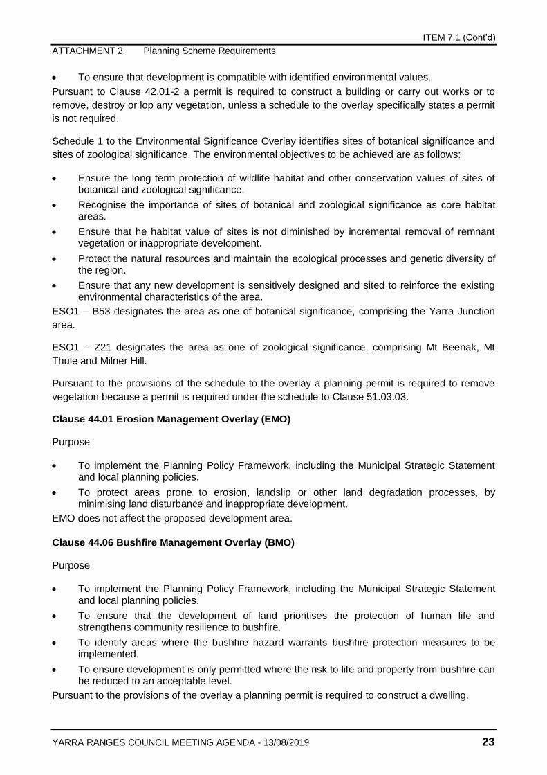
ITEM 7.1 (Cont’d)
ATTACHMENT 2. Planning Scheme Requirements
YARRA RANGES COUNCIL MEETING AGENDA - 13/08/2019 23
To ensure that development is compatible with identified environmental values.
Pursuant to Clause 42.01-2 a permit is required to construct a building or carry out works or to
remove, destroy or lop any vegetation, unless a schedule to the overlay specifically states a permit
is not required.
Schedule 1 to the Environmental Significance Overlay identifies sites of botanical significance and
sites of zoological significance. The environmental objectives to be achieved are as follows:
Ensure the long term protection of wildlife habitat and other conservation values of sites of botanical and zoological significance.
Recognise the importance of sites of botanical and zoological significance as core habitat areas.
Ensure that he habitat value of sites is not diminished by incremental removal of remnant vegetation or inappropriate development.
Protect the natural resources and maintain the ecological processes and genetic diversity of the region.
Ensure that any new development is sensitively designed and sited to reinforce the existing environmental characteristics of the area.
ESO1 – B53 designates the area as one of botanical significance, comprising the Yarra Junction
area.
ESO1 – Z21 designates the area as one of zoological significance, comprising Mt Beenak, Mt
Thule and Milner Hill.
Pursuant to the provisions of the schedule to the overlay a planning permit is required to remove
vegetation because a permit is required under the schedule to Clause 51.03.03.
Clause 44.01 Erosion Management Overlay (EMO)
Purpose
To implement the Planning Policy Framework, including the Municipal Strategic Statement and local planning policies.
To protect areas prone to erosion, landslip or other land degradation processes, by minimising land disturbance and inappropriate development.
EMO does not affect the proposed development area.
Clause 44.06 Bushfire Management Overlay (BMO)
Purpose
To implement the Planning Policy Framework, including the Municipal Strategic Statement and local planning policies.
To ensure that the development of land prioritises the protection of human life and strengthens community resilience to bushfire.
To identify areas where the bushfire hazard warrants bushfire protection measures to be implemented.
To ensure development is only permitted where the risk to life and property from bushfire can be reduced to an acceptable level.
Pursuant to the provisions of the overlay a planning permit is required to construct a dwelling.
ITEM 7.1 (Cont’d)
ATTACHMENT 2. Planning Scheme Requirements
YARRA RANGES COUNCIL MEETING AGENDA - 13/08/2019 24
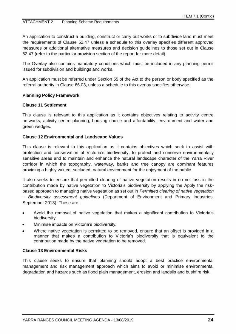
An application to construct a building, construct or carry out works or to subdivide land must meet
the requirements of Clause 52.47 unless a schedule to this overlay specifies different approved
measures or additional alternative measures and decision guidelines to those set out in Clause
52.47 (refer to the particular provision section of the report for more detail).
The Overlay also contains mandatory conditions which must be included in any planning permit
issued for subdivision and buildings and works.
An application must be referred under Section 55 of the Act to the person or body specified as the
referral authority in Clause 66.03, unless a schedule to this overlay specifies otherwise.
Planning Policy Framework
Clause 11 Settlement
This clause is relevant to this application as it contains objectives relating to activity centre
networks, activity centre planning, housing choice and affordability, environment and water and
green wedges.
Clause 12 Environmental and Landscape Values
This clause is relevant to this application as it contains objectives which seek to assist with
protection and conservation of Victoria’s biodiversity, to protect and conserve environmentally
sensitive areas and to maintain and enhance the natural landscape character of the Yarra River
corridor in which the topography, waterway, banks and tree canopy are dominant features
providing a highly valued, secluded, natural environment for the enjoyment of the public.
It also seeks to ensure that permitted clearing of native vegetation results in no net loss in the
contribution made by native vegetation to Victoria’s biodiversity by applying the Apply the risk-
based approach to managing native vegetation as set out in Permitted clearing of native vegetation
– Biodiversity assessment guidelines (Department of Environment and Primary Industries,
September 2013). These are:
Avoid the removal of native vegetation that makes a significant contribution to Victoria’s biodiversity.
Minimise impacts on Victoria’s biodiversity.
Where native vegetation is permitted to be removed, ensure that an offset is provided in a manner that makes a contribution to Victoria’s biodiversity that is equivalent to the contribution made by the native vegetation to be removed.
Clause 13 Environmental Risks
This clause seeks to ensure that planning should adopt a best practice environmental
management and risk management approach which aims to avoid or minimise environmental
degradation and hazards such as flood plain management, erosion and landslip and bushfire risk.
ITEM 7.1 (Cont’d)
ATTACHMENT 2. Planning Scheme Requirements
YARRA RANGES COUNCIL MEETING AGENDA - 13/08/2019 25
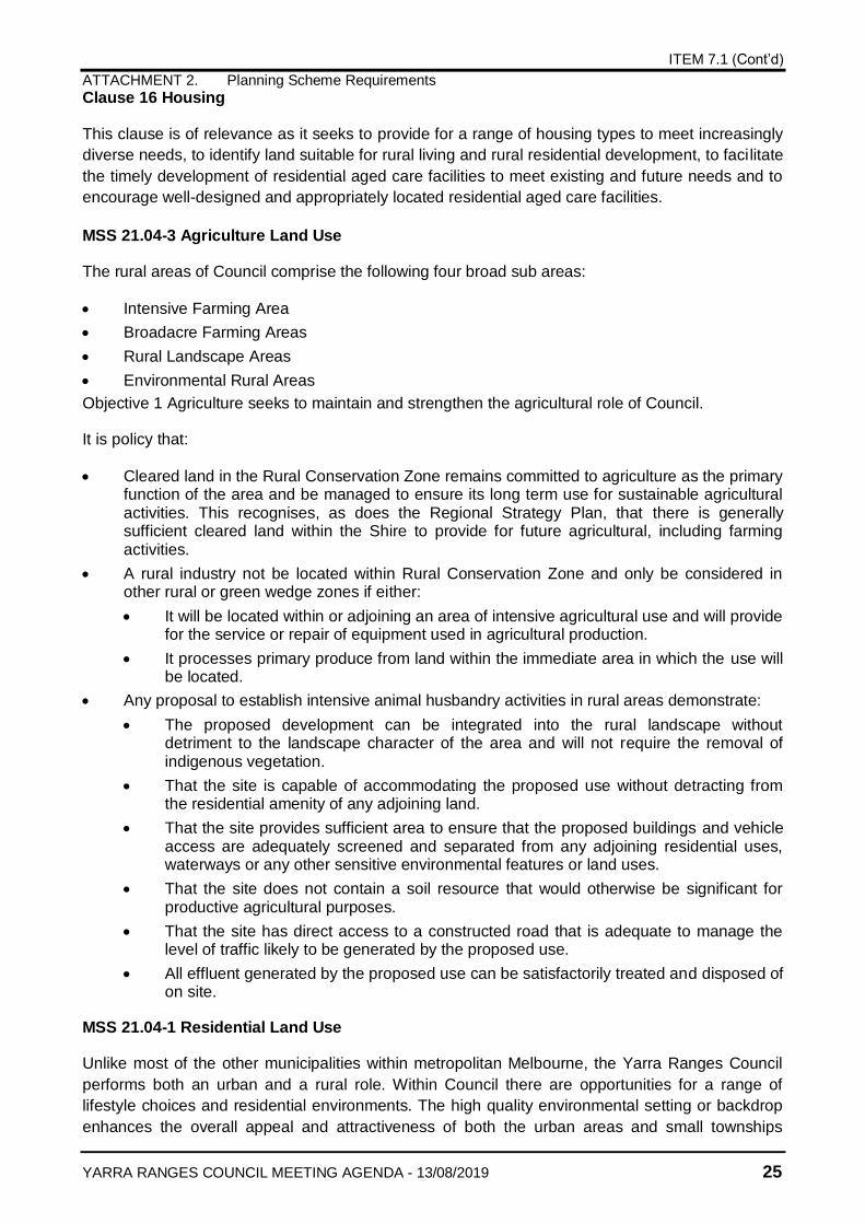
Clause 16 Housing
This clause is of relevance as it seeks to provide for a range of housing types to meet increasingly
diverse needs, to identify land suitable for rural living and rural residential development, to facilitate
the timely development of residential aged care facilities to meet existing and future needs and to
encourage well-designed and appropriately located residential aged care facilities.
MSS 21.04-3 Agriculture Land Use
The rural areas of Council comprise the following four broad sub areas:
Intensive Farming Area
Broadacre Farming Areas
Rural Landscape Areas
Environmental Rural Areas
Objective 1 Agriculture seeks to maintain and strengthen the agricultural role of Council.
It is policy that:
Cleared land in the Rural Conservation Zone remains committed to agriculture as the primary function of the area and be managed to ensure its long term use for sustainable agricultural activities. This recognises, as does the Regional Strategy Plan, that there is generally sufficient cleared land within the Shire to provide for future agricultural, including farming activities.
A rural industry not be located within Rural Conservation Zone and only be considered in other rural or green wedge zones if either:
It will be located within or adjoining an area of intensive agricultural use and will provide for the service or repair of equipment used in agricultural production.
It processes primary produce from land within the immediate area in which the use will be located.
Any proposal to establish intensive animal husbandry activities in rural areas demonstrate:
The proposed development can be integrated into the rural landscape without detriment to the landscape character of the area and will not require the removal of indigenous vegetation.
That the site is capable of accommodating the proposed use without detracting from the residential amenity of any adjoining land.
That the site provides sufficient area to ensure that the proposed buildings and vehicle access are adequately screened and separated from any adjoining residential uses, waterways or any other sensitive environmental features or land uses.
That the site does not contain a soil resource that would otherwise be significant for productive agricultural purposes.
That the site has direct access to a constructed road that is adequate to manage the level of traffic likely to be generated by the proposed use.
All effluent generated by the proposed use can be satisfactorily treated and disposed of on site.
MSS 21.04-1 Residential Land Use
Unlike most of the other municipalities within metropolitan Melbourne, the Yarra Ranges Council
performs both an urban and a rural role. Within Council there are opportunities for a range of
lifestyle choices and residential environments. The high quality environmental setting or backdrop
enhances the overall appeal and attractiveness of both the urban areas and small townships
ITEM 7.1 (Cont’d)
ATTACHMENT 2. Planning Scheme Requirements
YARRA RANGES COUNCIL MEETING AGENDA - 13/08/2019 26
scattered throughout the municipality. The character of individual areas is determined by the
combination of a number of key factors including lot size, road treatments, topography, and
vegetation cover.
Clause 21.04-1 provides direction and policy for Residential Land Use and includes objectives for
consolidation of housing, housing diversity, residential accommodation in commercial areas, and
green wedge residential.
Of relevance to this application is Objective 4 – Green Wedge Residential which seeks to provide
for residential use that reinforces the rural and landscape character of the rural areas and does not
lead to the loss of productive agricultural land. It is sought to do this through the following
strategies:
Encourage the location and siting of residential uses to respond to the characteristics of the site and the surrounding area.
Maintain the existing low density of residential development in the rural areas and protect the rural character and environmental and visual qualities of the surrounding area.
Encourage the location and siting of residential uses to avoid potential conflict with ongoing farming operations.
Protect and enhance environmental and landscape values, particularly those derived from remnant indigenous vegetation.
Support the continued use of the rural areas for farming and other agricultural pursuits that are compatible with the environmental features of the area.
Provide for dwellings which are required to manage the land for sustainable agricultural use in the Rural Conservation and Green Wedge Zones.
Provide for new residential accommodation in the Intensive Farming areas, only if it is directly associated with the operation and management of the land for agriculture.
When deciding on residential applications in rural areas consider as appropriate that:
In areas which are included in a Significant Landscape Overlay or Wildfire Management Overlay (in the Green Wedge and Rural Conservation Zones), building envelopes be sited to enable provision of utility services with minimal disturbance to established vegetation or other environmental features.
In the Rural Conservation and Green Wedge Zones, all buildings, including waste treatment and effluent disposal facilities associated with the dwelling, be located outside any land liable to flooding and be at least 30 metres from a watercourse and sited to avoid any detriment to the ecology of any stream or watercourse on or near the site.
The siting of a proposed dwelling allow for the maximum retention of vegetation, particularly remnant vegetation and other healthy trees above five metres in height.
In the Intensive Farming areas (GWZ1 and GWZ3) provide for new residential accommodation only if it is directly associated with the operation and management of the land for agricultural uses.
In the Rural Conservation Zone and Green Wedge Zones, any dwellings not associated with agricultural use, and other residential uses may be sensitive to disturbance from agricultural activities, not be located on sites where the residential use either:
Is likely to be adversely affected by ongoing agricultural operations.
Would limit the sustainable agricultural operations being carried out on the land.
ITEM 7.1 (Cont’d)
ATTACHMENT 2. Planning Scheme Requirements
YARRA RANGES COUNCIL MEETING AGENDA - 13/08/2019 27
MSS 21.06 Built Form
This clause recognises that Yarra Ranges includes areas of widely recognised natural beauty with
landscapes that offer some of the most attractive scenery in the State. Its towns, villages and rural
areas each have their own visual identity which is valued by residents and visitors. It is important
that new development respects and maintains these valued characteristics. Good design in the
built environment is not simply limited to aesthetically pleasing design. It encourages a sense of
local identity and seeks to improve people’s experience of a space or locality. It contributes to
creating places that people want to be in. The creation of a more sustainable urban form that
consolidates development in existing town centres has many environmental and social benefits. It
reduces car dependency, makes more efficient use of community infrastructure and adds life and
vitality to town centres.
Objective 6 – Buildings in Residential, Rural Living and Rural Areas seeks to ensure that any
development reflects the environmental and physical form of the surrounding neighbourhood.
It is policy when considering applications in the Rural Conservation and Green Wedge Zones:
The siting of a proposed dwelling allow for the maximum retention of vegetation particularly remnant vegetation and other healthy trees above 5 metres in height.
MSS 21.07 Landscape
This clause seeks to recognise that the rural areas of Council contain some of the most visually
attractive landscapes in Council comprising an intricate mix of open valleys, rolling foothills, steep
forested land and majestic mountain ranges.
The objectives of this clause are to retain and protect the scenic landscapes, rural and green wedge
character and special environmental features of Council.
It is policy that:
Any development proposal demonstrates that the proposed buildings and works will not compromise the landscape and environmental qualities of the surrounding area, or substantially change the natural land form.
All development be designed and sited to:
Have regard to the built form and to maintain design consistency with surrounding development and avoid detriment to the local environment.
Recognise the land capability of the site in terms of slope, land subsidence potential, viewlines, enhancement of landscape values, protection of water resources, retention of indigenous flora and fauna and associated wildlife habitats and other local amenity considerations, and so as to be unobtrusive in the surrounding landscape.
Avoid the removal of remnant vegetation, particularly healthy trees above five metres in height, and to minimise the disturbance to the root zone of such vegetation.
Avoid prominent ridgelines, hill tops and other visually exposed sites.
In the rural landscape areas, protect and enhance the environmental and landscape values particularly those derived from remnant indigenous vegetation.
The external surfaces, including roofs, of all buildings, except within Metropolitan Residential Areas as identified in plans showing Residential Areas, be treated with non-reflective materials and subdued colours to reduce the visual impact of the development on the surrounding area. This is particularly necessary where any development is proposed to be located on a visually prominent site.
On the completion of any development, the site be landscaped to protect and enhance the residential amenity, landscape character and any environmental features of the area.
ITEM 7.1 (Cont’d)
ATTACHMENT 2. Planning Scheme Requirements
YARRA RANGES COUNCIL MEETING AGENDA - 13/08/2019 28
The landscaping be planted within 12 months of the practical completion of the development or works and then be maintained to the satisfaction of the responsible authority.
In all areas outside the Urban Growth Boundary and in localities in residential zones which contain a tree canopy cover of mostly remnant vegetation, preference be given to landscaping using predominantly indigenous vegetation appropriate to the site, including upper, middle and lower storey plant species.
All roads, including internal access tracks, be located, designed and constructed in a manner compatible with surrounding landscape values and character and which minimises soil erosion.
LPPF 21.09-2 Environmental Hazards
This clause seeks to ensure that the use of land and development takes account of physical
development constraints such as flood, fire and landslip and to control development in these areas.
Strategies to achieve this include:
Encourage people to adopt principles and practices in the planning and development of
their land which minimise the risks from wildfires.
Limit development in areas prone to intense wildfire behaviour and provide township
protection features.
Maintain a safe and attractive living environment.
Promote safety of people and property.
Provide adequate design and services that allow rapid and effective response by
emergency services.
Ensure the community is aware of the risks of landslide, wildfire hazards, flooding (in
specific areas) and the need to limit, and even prevent, development where there are
problems or to apply special development criteria.
LPPF 22.05 Vegetation
The protection and enhancement of Council’s rich biodiversity is a prime objective of this planning
scheme. The retention and rehabilitation of remnant vegetation is fundamental to retaining the vast
range of wildlife habitats throughout Council. The environment strategies identified in Clause 21.07
of the Municipal Strategic Statement identify the need to protect significant vegetation through
appropriate controls and policies.
It is policy that:
Applications to remove mature trees or remnant vegetation demonstrate the need to remove such vegetation.
If it is proposed to remove vegetation to allow an approved use or development, and in order to conserve vegetation, consideration be given to whether there is any alternative location for the proposed buildings or works to avoid or minimise disturbance to the vegetation.
Preference be given to proposals which demonstrate that a net environmental gain will be achieved by allowing limited vegetation removal whilst providing for the long term protection and enhancement of other remnant vegetation on the site or within the immediate area.
ITEM 7.1 (Cont’d)
ATTACHMENT 2. Planning Scheme Requirements
YARRA RANGES COUNCIL MEETING AGENDA - 13/08/2019 29
LPPF 23 – Operation of the LPPF (Transitional)
Following amendment VC148, the PPF no longer references Clauses 21 and 22 of the Planning
Scheme. This provision has been introduced to ensure that the LPPF form part of the Planning
Policy Framework.
Particular Provisions
52.17 NATIVE VEGETATION
The purpose of this clause is to ensure permitted clearing of native vegetation results in no net loss
in the contribution made by native vegetation to Victoria’s biodiversity. This is achieved through
avoiding the removal of native vegetation that makes a significant contribution to Victoria’s
biodiversity, minimise impacts on Victoria’s biodiversity from the removal of native vegetation,
where native vegetation is permitted to be removed, ensure that an offset is provided in a manner
that makes a contribution to Victoria’s biodiversity that is equivalent to the contribution made by the
native vegetation to be removed; to manage native vegetation to minimise land and water
degradation; to manage native vegetation near buildings to reduce the threat to life and property
from bushfire.
A permit is required to remove, destroy or lop native vegetation, including dead native vegetation.
Provision: 53.02 Planning for Bushfire
This clause applies to an application under Clause 44.06 - Bushfire Management Overlay.
The purpose of this Clause is:
To implement the State Planning Policy Framework and the Local Planning Policy Framework, including the Municipal Strategic Statement and local planning policies.
To ensure that the development of land prioritises the protection of human life and strengthens community resilience to bushfire.
To ensure that the location, design and construction of development appropriately responds to the bushfire hazard.
To ensure development is only permitted where the risk to life, property and community infrastructure from bushfire can be reduced to an acceptable level.
To specify location, design and construction measures for a single dwelling that reduces the bushfire risk to life and property to an acceptable level.
Clause 53.02-1 applies to an application to construct a single dwelling or construct or carry out
works associated with a single dwelling where the following apply:
The land is zoned Neighbourhood Residential Zone, General Residential Zone, Residential Growth Zone, Urban Growth Zone, Low Density Residential Zone, Township Zone or Rural Living Zone.
There is only one dwelling on the lot.
An application under Clause 53.02-1 must meet all the approved measures.
Clause 53.02-2 applies to all other applications, including an application that does not meet all the
approved measures in Clause 53.02-1.
ITEM 7.1 (Cont’d)
ATTACHMENT 2. Planning Scheme Requirements
YARRA RANGES COUNCIL MEETING AGENDA - 13/08/2019 30
CLAUSE 51.03
The purpose of the clause is to facilitate consistency between the Yarra Ranges Planning Scheme
and the Upper Yarra Valley and Dandenong Ranges Regional Strategy Plan in accordance with
Section 46F of the Planning and Environment Act 1987. The use of land must meet the
requirements of the schedule to this clause.
Pursuant to the provisions of the schedule to Clause 51.03, a planning permit is required to remove
vegetation.
ITEM 7.1
ATTACHMENT 3. Advertising map
YARRA RANGES COUNCIL MEETING AGENDA - 13/08/2019 31
ITEM 7.1
ATTACHMENT 4. Aerial Photo
YARRA RANGES COUNCIL MEETING AGENDA - 13/08/2019 32
ITEM 7.1
ATTACHMENT 5. Plans
YARRA RANGES COUNCIL MEETING AGENDA - 13/08/2019 33
ITEM 7.1 (Cont’d)
ATTACHMENT 5. Plans
YARRA RANGES COUNCIL MEETING AGENDA - 13/08/2019 34
ITEM 7.1
ATTACHMENT 5. Plans
YARRA RANGES COUNCIL MEETING AGENDA - 13/08/2019 35
ITEM 7.1 (Cont’d)
ATTACHMENT 5. Plans
YARRA RANGES COUNCIL MEETING AGENDA - 13/08/2019 36
ITEM 7.1
ATTACHMENT 6. Land Management Plan
YARRA RANGES COUNCIL MEETING AGENDA - 13/08/2019 37
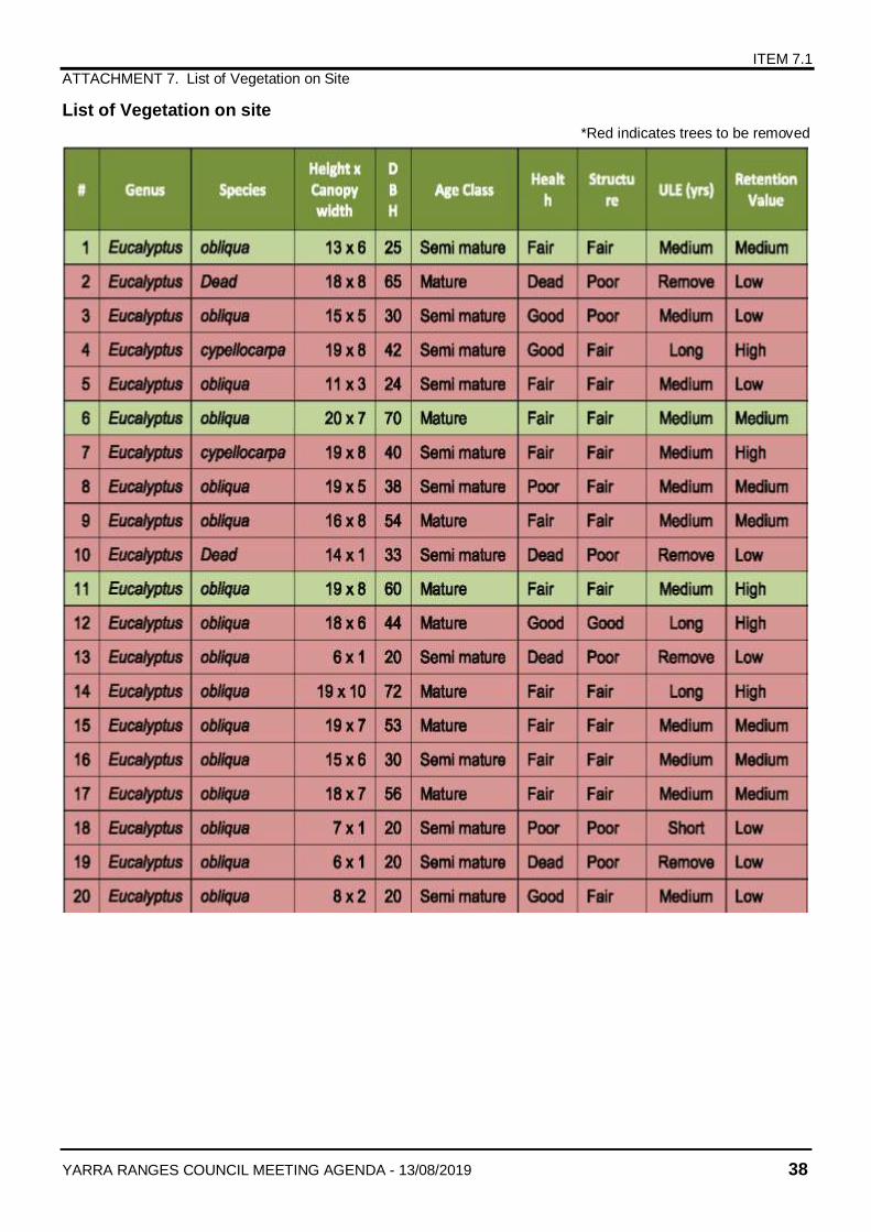
ITEM 7.1
ATTACHMENT 7. List of Vegetation on Site
YARRA RANGES COUNCIL MEETING AGENDA - 13/08/2019 38
List of Vegetation on site
*Red indicates trees to be removed
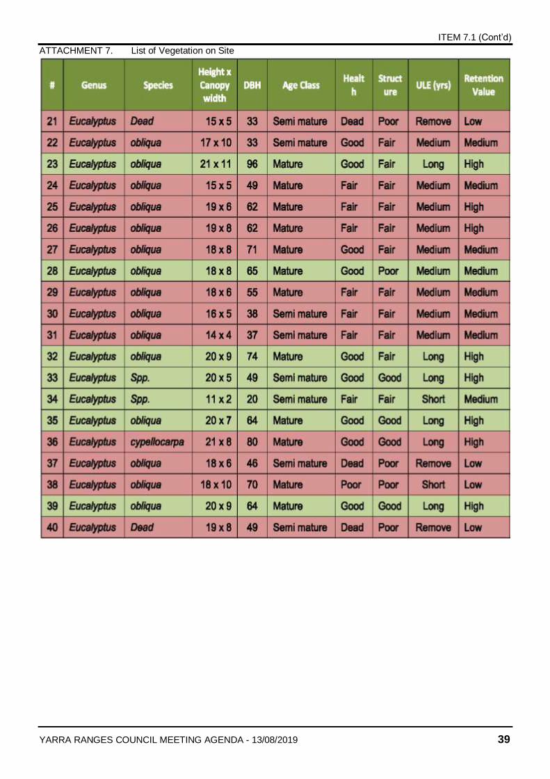
ITEM 7.1 (Cont’d)
ATTACHMENT 7. List of Vegetation on Site
YARRA RANGES COUNCIL MEETING AGENDA - 13/08/2019 39
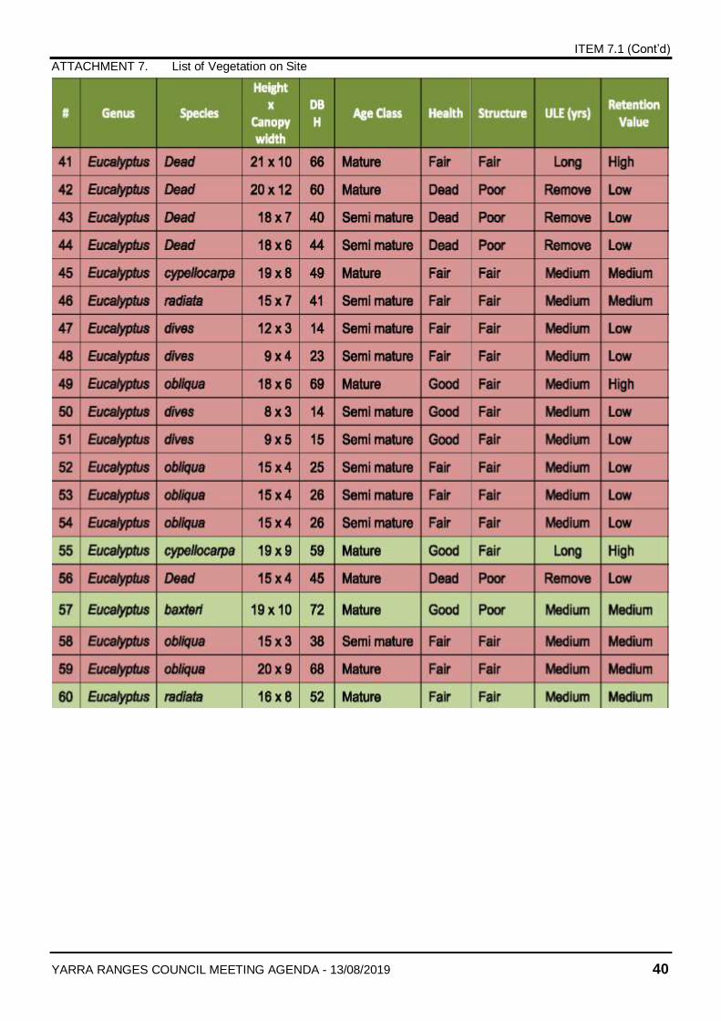
ITEM 7.1 (Cont’d)
ATTACHMENT 7. List of Vegetation on Site
YARRA RANGES COUNCIL MEETING AGENDA - 13/08/2019 40
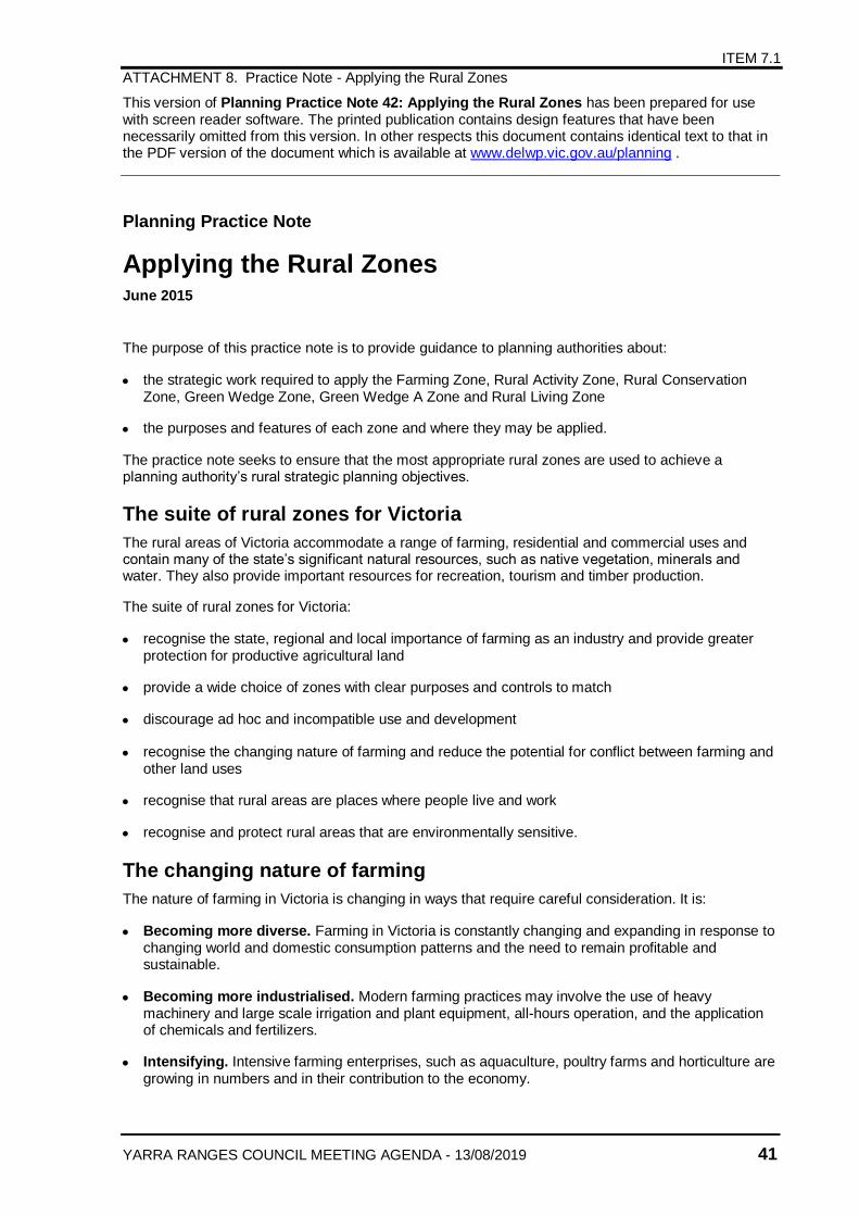
ITEM 7.1
ATTACHMENT 8. Practice Note - Applying the Rural Zones
YARRA RANGES COUNCIL MEETING AGENDA - 13/08/2019 41
This version of Planning Practice Note 42: Applying the Rural Zones has been prepared for use with screen reader software. The printed publication contains design features that have been necessarily omitted from this version. In other respects this document contains identical text to that in the PDF version of the document which is available at www.delwp.vic.gov.au/planning .
Planning Practice Note
Applying the Rural Zones June 2015
The purpose of this practice note is to provide guidance to planning authorities about:
the strategic work required to apply the Farming Zone, Rural Activity Zone, Rural Conservation Zone, Green Wedge Zone, Green Wedge A Zone and Rural Living Zone
the purposes and features of each zone and where they may be applied.
The practice note seeks to ensure that the most appropriate rural zones are used to achieve a planning authority’s rural strategic planning objectives.
The suite of rural zones for Victoria
The rural areas of Victoria accommodate a range of farming, residential and commercial uses and contain many of the state’s significant natural resources, such as native vegetation, minerals and water. They also provide important resources for recreation, tourism and timber production.
The suite of rural zones for Victoria:
recognise the state, regional and local importance of farming as an industry and provide greater protection for productive agricultural land
provide a wide choice of zones with clear purposes and controls to match
discourage ad hoc and incompatible use and development
recognise the changing nature of farming and reduce the potential for conflict between farming and other land uses
recognise that rural areas are places where people live and work
recognise and protect rural areas that are environmentally sensitive.
The changing nature of farming
The nature of farming in Victoria is changing in ways that require careful consideration. It is:
Becoming more diverse. Farming in Victoria is constantly changing and expanding in response to changing world and domestic consumption patterns and the need to remain profitable and sustainable.
Becoming more industrialised. Modern farming practices may involve the use of heavy machinery and large scale irrigation and plant equipment, all-hours operation, and the application of chemicals and fertilizers.
Intensifying. Intensive farming enterprises, such as aquaculture, poultry farms and horticulture are growing in numbers and in their contribution to the economy.
ITEM 7.1 (Cont’d)
ATTACHMENT 8. Practice Note - Applying the Rural Zones
YARRA RANGES COUNCIL MEETING AGENDA - 13/08/2019 42
Aggregating. In western Victoria particularly, farms are becoming bigger to achieve the economies of scale for farm investment and to maintain productivity.
Undergoing social change. More farmers are taking on off-farm work, the economic value of off-farm work is increasing, and there is a shift from full-time to part-time farming in some rural areas.
More changes in farming structures and practices are expected due to drier climatic conditions and growing community pressure for more efficient water use by all industries.
At the same time, more people are seeking to live in rural areas for a range of social, environmental and economic reasons. As a result, in some rural areas:
there is more competition for rural land, which is affecting rural land prices and the capacity of farmers to expand their businesses and maintain productivity
there is renewed interest in part-time small-scale farming
more people are living in rural areas for lifestyle reasons not related to farming increasing the potential for land use conflicts because people pursuing a rural lifestyle often have amenity expectations that conflict with modern farming practices
local rural economies are diversifying, as rural land is used for more diverse purposes (such as tourism or recreation).
Victoria’s changing rural landscape requires planning authorities to think strategically about their farming areas and rural settlement patterns, so that sustainable farming is promoted and potential conflicts between farming and other land uses are avoided.
Strategic planning for rural areas
Sound strategic planning for rural areas is essential to ensuring that land use and development achieves the planning authority’s vision, objectives and desired outcomes for an area. It can help ensure that:
use and development in rural areas fits into the overall strategic planning of the municipality
farmland and farming industries of state, regional or local significance are protected
housing development in rural areas is consistent with the housing needs and settlement strategy of an area
future use of existing natural resources, including productive agricultural land, water, and mineral and energy resources, is sustainable
scarce resources, such as water, are protected
social networks and infrastructure essential to rural communities are maintained
existing visual and environmental qualities of rural areas are protected
conflicts between farming and other land uses are avoided
the most appropriate planning scheme tools (for example, the right rural zone) are used to achieve strategic planning objectives.
Applying a new rural zone or making adjustments to a schedule to an existing rural zone should be underpinned by clearly expressed planning policies in the planning scheme. If a proposed change is at odds with the existing policy framework, either a different planning tool or approach should be used or the policy framework itself might need re-assessment.
ITEM 7.1 (Cont’d)
ATTACHMENT 8. Practice Note - Applying the Rural Zones
YARRA RANGES COUNCIL MEETING AGENDA - 13/08/2019 43
The existing State Planning Policy Framework (SPPF) and Local Planning Policy Framework (LPPF) in the planning scheme should be the starting point for deciding whether the council’s strategic objectives are still valid and sound, or whether new strategic work is required. Many councils have already undertaken strategic planning, policies and resource management studies for their rural areas and used this work to articulate rural strategic objectives in their Municipal Strategic Statements (MSS).
New strategic work may not be required if the existing MSS addresses the key rural land use issues and adequately reflects the planning outcomes that the council wants to achieve. The scheme may already contain a sufficient strategic basis for applying a different rural zone or making adjustments to an existing rural zone.
However, if the MSS objectives are no longer relevant, they do not provide clear guidance for decision-making, or there are strategic gaps, new strategic work for a part or parts of the municipality may be required.
Before commencing new strategic work, the council should review the policy components of its planning scheme, past and present council strategic work, relevant studies prepared by government departments and agencies, relevant recommendations of planning panels and past planning scheme review recommendations. This will help to establish whether new strategic work is required, the scope of the strategic work and the main issues to be focussed on.
There is no prescribed content or format for a rural strategy or study, however it should:
develop a vision, role and purpose for the rural area
identify the values and features within the rural area
identify the key opportunities and constraints
establish a strategic direction for land use and development within the rural area
articulate how the strategic vision for the rural area is to be implemented through the planning scheme.
The information used to develop the strategy should be tailored to suit the area. In general it should include an assessment of:
the state, regional and local strategic planning policies and objectives for the area, including relevant regional growth plans or strategies
the housing needs of the municipality and likely future trends which is particularly relevant if one of the aims of the strategy is to provide for rural living development
the physical attributes of the land and its capacity to support productive agricultural uses including soil type, climate, vegetation cover, access to water, slope and drainage
agricultural trends in the area, including agricultural productivity, changes in farming practices and processes, and farm investment patterns
the natural resources and environmental features in the area and their importance including flora and fauna, significant habitats, wetlands, scenic landscapes and sites of archaeological or cultural significance
environmental hazards that could affect how the land is used and developed, such as erosion, salinity, flooding and wildfire risk
the existing lot size and land use patterns
infrastructure available for agriculture and other relevant land uses
settlement patterns in the area.
ITEM 7.1 (Cont’d)
ATTACHMENT 8. Practice Note - Applying the Rural Zones
YARRA RANGES COUNCIL MEETING AGENDA - 13/08/2019 44
Implementing rural strategic objectives
A planning authority may need to use a number of VPP tools to successfully implement its rural strategic objectives. There are circumstances where a zone and one or more overlays may be needed to deliver the desired outcome. Councils should think laterally about the mix of policies and controls required to achieve their objectives and be prepared to consider using a range of tools to achieve the desired strategic outcomes.
In deciding which rural zone should apply, the following principles should be considered:
The zone should support and give effect to the SPPF.
The zone should broadly support all relevant policy areas in the MSS (for example, economic, housing, environment and infrastructure policy).
The rationale for applying the zone should be clearly discernible in the LPPF.
Implement the recommendations or actions of any relevant rural strategy or study.
The zone should be applied in a way that is consistent with its purpose.
The requirements of any applicable Minister’s Direction must be met.
The existing size or pattern of lots in an area should not be the sole basis for deciding to apply a particular zone. For example, it is not appropriate to decide that the Rural Living Zone should be applied to an area simply because it comprises small lots. Traditionally, farms have comprised multiple lots, sometimes contiguous, sometimes in different locations. The fact that an area may comprise many lots does not mean that it cannot be used productively or should not be included in a zone that supports and protects farming. Many factors will determine the suitability of an area for farming, rural living, rural industry, rural conservation or green wedge land.
Local planning policy
Wide discretion is available in the rural zones, particularly the Farming Zone, Rural Activity Zone and Rural Living Zone. To guide the exercise of this discretion and fully implement their strategic objectives, the planning authority should consider whether a Local Planning Policy (LPP) is necessary. An LPP can help to establish realistic expectations about how land in an area may be used and developed, and provide the responsible authority with a sound basis for making consistent, strategic decisions. Refer to Planning Practice Note 8: Writing a Local Planning Policy for more guidance on using local planning policies.
The zones in detail
The six zones are summarised as follows:
Farming Zone – a zone that is strongly focussed on protecting and promoting farming and agriculture
Rural Activity Zone – a mixed use rural zone that caters for farming and other compatible land uses
Rural Conservation Zone – a conservation zone that caters for rural areas with special environmental characteristics
Green Wedge Zone – a zone that provides for all agricultural uses and limits non-rural uses to those that either support agriculture or tourism, or that are essential for urban development but cannot locate in urban areas for amenity or other reasons
Green Wedge A Zone – a zone that provides for all agricultural uses and limits non-rural uses to
those that support agriculture, tourism, schools, major infrastructure and rural living
Rural Living Zone – a zone that caters for residential use in a rural setting.
ITEM 7.1 (Cont’d)
ATTACHMENT 8. Practice Note - Applying the Rural Zones
YARRA RANGES COUNCIL MEETING AGENDA - 13/08/2019 45
The zone purposes
All of the zones provide for the use of land for agriculture; however while it is implicit in the purpose of the Farming Zone, Rural Activity Zone, Green Wedge Zone and Green Wedge A Zone that farming will be a primary land use activity, in the Rural Conservation Zone and Rural Living Zone, farming is subordinate to other land uses or the environmental values of the land.
Farming Zone Purpose
To implement the SPPF and the LPPF, including the MSS and local planning policies.
To provide for the use of land for agriculture.
To encourage the retention of productive agricultural land.
To ensure that non-agricultural uses, including dwellings, do not adversely affect the use of land for agriculture.
To encourage the retention of employment and population to support rural communities.
To encourage use and development of land based on comprehensive and sustainable land management practices and infrastructure provision.
Rural Activity Zone Purpose
To implement the SPPF and the LPPF, including the MSS and local planning policies.
To provide for the use of land for agriculture.
To provide for other uses and development, in appropriate locations, which are compatible with agriculture and the environmental and landscape characteristics of the area.
To ensure that use and development does not adversely affect surrounding land uses.
To provide for the use and development of land for the specific purposes identified in a schedule to this zone.
To protect and enhance natural resources and the biodiversity of the area.
To encourage use and development of land based on comprehensive and sustainable land management practices and infrastructure provision.
Green Wedge Zone Purpose
To implement the SPPF and the LPPF, including the MSS and local planning policies.
To provide for the use of land for agriculture.
To recognise, protect and conserve green wedge land for its agricultural, environmental, historic, landscape, recreational and tourism opportunities, and mineral and stone resources.
To encourage use and development that is consistent with sustainable land management practices.
To encourage sustainable farming activities and provide opportunity for a variety of productive agricultural uses.
To protect, conserve and enhance the cultural heritage significance and the character of open rural and scenic non-urban landscapes.
To protect and enhance the biodiversity of the area.
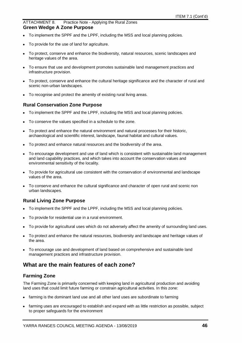
ITEM 7.1 (Cont’d)
ATTACHMENT 8. Practice Note - Applying the Rural Zones
YARRA RANGES COUNCIL MEETING AGENDA - 13/08/2019 46
Green Wedge A Zone Purpose
To implement the SPPF and the LPPF, including the MSS and local planning policies.
To provide for the use of land for agriculture.
To protect, conserve and enhance the biodiversity, natural resources, scenic landscapes and heritage values of the area.
To ensure that use and development promotes sustainable land management practices and infrastructure provision.
To protect, conserve and enhance the cultural heritage significance and the character of rural and scenic non-urban landscapes.
To recognise and protect the amenity of existing rural living areas.
Rural Conservation Zone Purpose
To implement the SPPF and the LPPF, including the MSS and local planning policies.
To conserve the values specified in a schedule to the zone.
To protect and enhance the natural environment and natural processes for their historic, archaeological and scientific interest, landscape, faunal habitat and cultural values.
To protect and enhance natural resources and the biodiversity of the area.
To encourage development and use of land which is consistent with sustainable land management and land capability practices, and which takes into account the conservation values and environmental sensitivity of the locality.
To provide for agricultural use consistent with the conservation of environmental and landscape values of the area.
To conserve and enhance the cultural significance and character of open rural and scenic non urban landscapes.
Rural Living Zone Purpose
To implement the SPPF and the LPPF, including the MSS and local planning policies.
To provide for residential use in a rural environment.
To provide for agricultural uses which do not adversely affect the amenity of surrounding land uses.
To protect and enhance the natural resources, biodiversity and landscape and heritage values of the area.
To encourage use and development of land based on comprehensive and sustainable land management practices and infrastructure provision.
What are the main features of each zone?
Farming Zone
The Farming Zone is primarily concerned with keeping land in agricultural production and avoiding land uses that could limit future farming or constrain agricultural activities. In this zone:
farming is the dominant land use and all other land uses are subordinate to farming
farming uses are encouraged to establish and expand with as little restriction as possible, subject to proper safeguards for the environment
ITEM 7.1 (Cont’d)
ATTACHMENT 8. Practice Note - Applying the Rural Zones
YARRA RANGES COUNCIL MEETING AGENDA - 13/08/2019 47
non-farm dwellings and land uses not related to farming may be considered but should not limit the operation and expansion of agricultural uses
farm-related tourism and retailing uses may be considered
uses that could lead to the loss or fragmentation of productive agricultural land, or which could be adversely affected by farming activities, are prohibited
land subdivision that could take farmland out of production or limit future farming productivity is discouraged
the minimum lot size for subdivision may be tailored to suit the farming practices and productivity of the land.
This zone provides a minimum lot size of 40 hectares unless an alternative is specified in a schedule to the zone. The creation of smaller lots is prohibited unless the subdivision is for an existing dwelling, is the re-subdivision of existing lots or the creation of a small lot for a utility installation.
Productive agricultural land
Productive agricultural land generally has one or more of the following characteristics:
suitable soil type
suitable climatic conditions
suitable agricultural infrastructure, in particular irrigation and drainage systems
a present pattern of subdivision favourable for sustainable agricultural production.
The basic physical characteristics of the land, such as soil type and climate, access to water, and infrastructure are critical to determining the agricultural use of land and whether agricultural productivity can be sustained in the future. However, productivity is also affected by many other factors, including market demand, access to suitable storage and transport facilities, access to efficient processing and value adding capability, availability of technology, the skills of the farmer, research and development, access to capital, marketing, effective industry support, availability of land for expansion and farm labour costs.
Productive agricultural land is a finite resource that makes a significant contribution to the economy of the state and individual municipalities. Its significance is recognised in the SPPF.
Productive agricultural land should be clearly identified and protected in the planning scheme. If the protection and retention of this land for agricultural production is of primary strategic importance, then it should be included in the Farming Zone.
The Farming Zone is designed to encourage diverse farming practices, some of which can have significant off-site impacts. For this reason, the level of amenity that can be expected in this zone will usually not be compatible with sensitive uses, particularly housing.
Decision guidelines
In reaching a decision on a proposal in this zone, the responsible authority must give significant weight to the farming productivity of the land and the relevance of the proposal to farming. There is an expectation that decisions will be made in favour of protecting and supporting farming. In relation to agricultural issues, the responsible authority must consider:
whether the use or development will support and enhance agricultural production
whether the use or development will permanently remove land from agricultural production
the potential for the use or development to limit the operation and expansion of adjoining and nearby agricultural uses
the capacity of the site to sustain the agricultural use
ITEM 7.1 (Cont’d)
ATTACHMENT 8. Practice Note - Applying the Rural Zones
YARRA RANGES COUNCIL MEETING AGENDA - 13/08/2019 48
the agricultural qualities of the land, such as soil quality, access to water and access to rural infrastructure
any integrated land management plan prepared for the site.
In relation to dwellings, the responsible authority must also consider:
whether the dwelling will result in the loss or fragmentation of productive agricultural land
whether the dwelling will be adversely affected by agricultural activities on adjacent and nearby land due to dust, noise, odour, use of chemicals and farm machinery, traffic and hours of operation
whether the dwelling will adversely affect the operation and expansion of adjoining and nearby agricultural uses
the potential for the proposal to lead to a concentration or proliferation of dwellings in the area and the impact of this on the use of the land for agriculture.
The zone’s focus on farming does not mean that there should be little or no consideration of the impact of farming on the environment. The zone encourages farming based on comprehensive and sustainable land management practices and a planning permit is required to establish or expand certain farming enterprises. However, in these cases, the focus of the responsible authority’s decision will usually be on whether off-site impacts that may result from the proposal are reasonable for a farming area.
Rural Activity Zone
The main feature of the Rural Activity Zone is the flexibility that it provides for farming and other land uses to co-exist. In this zone:
the purpose and provisions support the continuation and growth of farming but provide the opportunity for non-farming uses to be considered in appropriate locations
a wide range of tourism, commercial and retail uses are supported
farming uses are encouraged to establish and expand, subject to proper safeguards for the environment and amenity considerations
a planning permit is always required to use land for a dwelling.
Because the mix of uses that is supported in the Rural Activity Zone is wide-ranging, the planning scheme should be clear about:
what the planning authority wants to achieve in the area where the zone is to be applied
how discretion in the zone will be exercised.
This can be done by:
setting out clear objectives for the zone and explaining how discretion in the zone will be exercised in the LPPF, or
including a purpose statement in the schedule to the zone. If this option is chosen, the statement should be inserted above the table setting out minimum and maximum areas, it should not repeat or contradict the SPPF and LPPF, and it should be more specific than the zone purpose.
If the planning scheme is clear about what is to be achieved in the zone, this will enable the responsible authority to make decisions on a consistent, strategic basis and avoid land use conflicts in the future.
A purpose statement in the schedule to the zone may describe:
desired or preferred mix of land uses
ITEM 7.1 (Cont’d)
ATTACHMENT 8. Practice Note - Applying the Rural Zones
YARRA RANGES COUNCIL MEETING AGENDA - 13/08/2019 49
desired or preferred locations for particular land uses
preferred approaches for managing off-site land use impacts
a specific need that a proposal should meet.
A good purpose statement should reference local conditions, be grounded in reality, and help the responsible authority to make planning decisions, for example:
To achieve a mix of nature-based recreation facilities and tourist accommodation that complements the wilderness values of Gumnut National Park and is compatible with organic food production activities in the area.
The mix of uses that a planning authority may want to encourage in the zone could include:
farming, rural industry and associated agribusiness
farming and tourist facilities
intensive animal husbandry and associated rural processing industries
nature-based tourism and recreation facilities
agricultural and environmental education and research facilities.
The application of the Rural Activity Zone does not mean that protecting or maintaining farming activities will be of low importance. The zone caters for a wide range of farming activities, including intensive animal husbandry, rural processing industries and timber production, and a planning authority may want to apply the zone to encourage a particular mix of farming and non-farming activities. However, the needs of farmers will need to be balanced with the council’s other planning objectives for the area.
The mix of uses that is encouraged in the zone should complement the environmental and landscape values of the land, and support the council’s overall urban and rural settlement strategies. It would be inappropriate to apply the zone to encourage a rural mixed use area if the land is required for urban development in the future, or if the particular uses would be better located in an existing town, where there is access to a wider range of urban services and infrastructure.
The zone should not be mistaken for a quasi rural residential zone. Housing is only one of a number of uses that may be considered in the zone, and, in some circumstances, it may be incompatible with the particular mix of uses that the planning authority is seeking to achieve.
Tourism
Rural Victoria is home to many trails, transport routes and nature-based attractions that have strong tourist appeal and create demand for recreation and tourism facilities and services. Tourism can promote and facilitate economic activity that supports aspects of regional and rural life. For example, farm stays, cellar door sales and the sales of local produce support agriculture.
A range of farming-related tourism uses may be considered in the Farming Zone (such as farm stays, group accommodation, market, residential hotel, restaurants, and primary produce sales). However, if a planning authority is keen to facilitate the establishment of larger scale tourism uses or a more diverse mix of tourism and recreation uses, the Rural Activity Zone may be a more appropriate zone to apply as hotel and tavern are permit required uses.
In deciding to apply the Rural Activity Zone to facilitate tourism in an area, matters to be considered include:
the need to protect the agricultural, environmental and cultural values of the area
the scale and mix of tourism and recreation uses to be encouraged
whether there are opportunities to build alliances between tourism business operators, farmers, food and wine producers and trail network managers
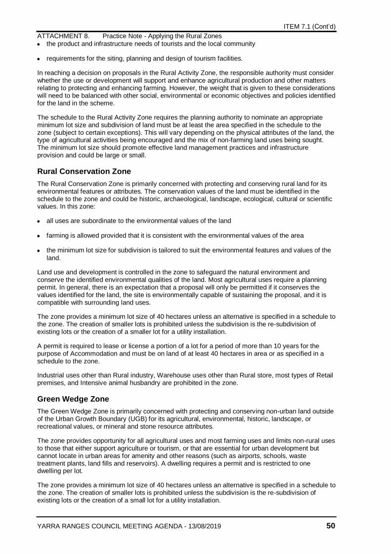
ITEM 7.1 (Cont’d)
ATTACHMENT 8. Practice Note - Applying the Rural Zones
YARRA RANGES COUNCIL MEETING AGENDA - 13/08/2019 50
the product and infrastructure needs of tourists and the local community
requirements for the siting, planning and design of tourism facilities.
In reaching a decision on proposals in the Rural Activity Zone, the responsible authority must consider whether the use or development will support and enhance agricultural production and other matters relating to protecting and enhancing farming. However, the weight that is given to these considerations will need to be balanced with other social, environmental or economic objectives and policies identified for the land in the scheme.
The schedule to the Rural Activity Zone requires the planning authority to nominate an appropriate minimum lot size and subdivision of land must be at least the area specified in the schedule to the zone (subject to certain exceptions). This will vary depending on the physical attributes of the land, the type of agricultural activities being encouraged and the mix of non-farming land uses being sought. The minimum lot size should promote effective land management practices and infrastructure provision and could be large or small.
Rural Conservation Zone
The Rural Conservation Zone is primarily concerned with protecting and conserving rural land for its environmental features or attributes. The conservation values of the land must be identified in the schedule to the zone and could be historic, archaeological, landscape, ecological, cultural or scientific values. In this zone:
all uses are subordinate to the environmental values of the land
farming is allowed provided that it is consistent with the environmental values of the area
the minimum lot size for subdivision is tailored to suit the environmental features and values of the land.
Land use and development is controlled in the zone to safeguard the natural environment and conserve the identified environmental qualities of the land. Most agricultural uses require a planning permit. In general, there is an expectation that a proposal will only be permitted if it conserves the values identified for the land, the site is environmentally capable of sustaining the proposal, and it is compatible with surrounding land uses.
The zone provides a minimum lot size of 40 hectares unless an alternative is specified in a schedule to the zone. The creation of smaller lots is prohibited unless the subdivision is the re-subdivision of existing lots or the creation of a smaller lot for a utility installation.
A permit is required to lease or license a portion of a lot for a period of more than 10 years for the purpose of Accommodation and must be on land of at least 40 hectares in area or as specified in a schedule to the zone.
Industrial uses other than Rural industry, Warehouse uses other than Rural store, most types of Retail premises, and Intensive animal husbandry are prohibited in the zone.
Green Wedge Zone
The Green Wedge Zone is primarily concerned with protecting and conserving non-urban land outside of the Urban Growth Boundary (UGB) for its agricultural, environmental, historic, landscape, or recreational values, or mineral and stone resource attributes.
The zone provides opportunity for all agricultural uses and most farming uses and limits non-rural uses to those that either support agriculture or tourism, or that are essential for urban development but cannot locate in urban areas for amenity and other reasons (such as airports, schools, waste treatment plants, land fills and reservoirs). A dwelling requires a permit and is restricted to one dwelling per lot.
The zone provides a minimum lot size of 40 hectares unless an alternative is specified in a schedule to the zone. The creation of smaller lots is prohibited unless the subdivision is the re-subdivision of existing lots or the creation of a small lot for a utility installation.

ITEM 7.1 (Cont’d)
ATTACHMENT 8. Practice Note - Applying the Rural Zones
YARRA RANGES COUNCIL MEETING AGENDA - 13/08/2019 51
A permit is required to lease or license a portion of land for a period of more than 10 years for the purpose of Accommodation and must be on land of at least 40 hectares in area or as apecified in a schedule to the zone.
Industrial uses other than Rural industry, Warehouse uses (except Rural store), and most types of Retail premises are prohibited in the zone.
Green Wedge A Zone
The Green Wedge A Zone is primarily concerned with protecting and conserving non-urban land outside of the Urban Growth Boundary (UGB) for its agricultural, environmental, historic, landscape, infrastructure, natural resource or rural living attributes.
The zone provides opportunity for all agricultural uses and limits non-rural uses to those that either support agriculture or tourism, schools, major infrastructure and rural living. A dwelling requires a permit and is restricted to one dwelling per lot.
The zone provides a minimum lot size of eight hectares unless an alternative is specified in a schedule to the zone. The creation of smaller lots is prohibited unless the subdivision is the re-subdivision of existing lots or the creation of a small lot for a utility installation.
A permit is required to lease or license a portion of a lot for a period of more than 10 years for the purpose of accommodation and must be on land of at least 8 hectares in area or as specified in a schedule to the zone.
Industrial uses other than Rural industry (except for Abattoir and Sawmill), Warehouse uses (except Rural store), most types of Retail premises, and Intensive animal husbandry are prohibited in the zone.
Rural Living Zone
This zone provides for residential use in a rural environment. It is designed to cater for lots in a rural setting that are large enough to accommodate a dwelling and a farming use. The farming use is likely to be carried on for reasons other than the need to provide a significant source of household income.
In this zone:
it is not essential that a dwelling be genuinely associated with a farming use of the land
some farming may take place on the land, however this will not always be the case
residents have a reasonable expectation that their amenity will be protected
a wider range of tourism, commercial and retail uses may be considered in the zone.
Although the Rural Living Zone is catering primarily for residential use, the allotment size and subdivision layout should provide the opportunity for farming activities to occur, without adversely affecting the natural environment or the amenity of surrounding land uses. This means that the minimum lot size could be quite large.
The zone provides a minimum lot size of 2 hectares unless an alternative is specified in a schedule to the zone. The creation of smaller lots is prohibited unless the subdivision is the re-subdivision of existing lots, creating lot sizes consistent with the schedule or the creation of a smaller lot for a utility installation.
If the planning authority’s objective is to encourage rural residential development at densities that are defacto large residential lots or which would preclude farming activities, then it should consider applying the Low Density Residential Zone.
Because of the zone’s primarily residential function, a planning authority must be able to show that using the Rural Living Zone is part of its strategy to provide appropriate housing diversity and choice to meet housing needs.
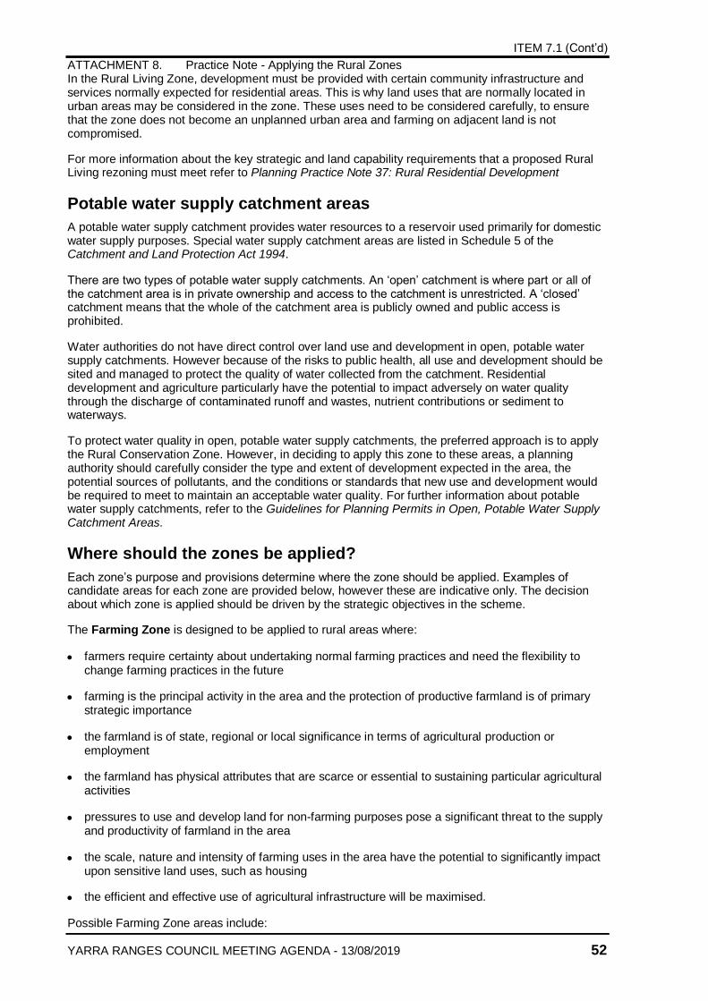
ITEM 7.1 (Cont’d)
ATTACHMENT 8. Practice Note - Applying the Rural Zones
YARRA RANGES COUNCIL MEETING AGENDA - 13/08/2019 52
In the Rural Living Zone, development must be provided with certain community infrastructure and services normally expected for residential areas. This is why land uses that are normally located in urban areas may be considered in the zone. These uses need to be considered carefully, to ensure that the zone does not become an unplanned urban area and farming on adjacent land is not compromised.
For more information about the key strategic and land capability requirements that a proposed Rural Living rezoning must meet refer to Planning Practice Note 37: Rural Residential Development
Potable water supply catchment areas
A potable water supply catchment provides water resources to a reservoir used primarily for domestic water supply purposes. Special water supply catchment areas are listed in Schedule 5 of the Catchment and Land Protection Act 1994.
There are two types of potable water supply catchments. An ‘open’ catchment is where part or all of the catchment area is in private ownership and access to the catchment is unrestricted. A ‘closed’ catchment means that the whole of the catchment area is publicly owned and public access is prohibited.
Water authorities do not have direct control over land use and development in open, potable water supply catchments. However because of the risks to public health, all use and development should be sited and managed to protect the quality of water collected from the catchment. Residential development and agriculture particularly have the potential to impact adversely on water quality through the discharge of contaminated runoff and wastes, nutrient contributions or sediment to waterways.
To protect water quality in open, potable water supply catchments, the preferred approach is to apply the Rural Conservation Zone. However, in deciding to apply this zone to these areas, a planning authority should carefully consider the type and extent of development expected in the area, the potential sources of pollutants, and the conditions or standards that new use and development would be required to meet to maintain an acceptable water quality. For further information about potable water supply catchments, refer to the Guidelines for Planning Permits in Open, Potable Water Supply Catchment Areas.
Where should the zones be applied?
Each zone’s purpose and provisions determine where the zone should be applied. Examples of candidate areas for each zone are provided below, however these are indicative only. The decision about which zone is applied should be driven by the strategic objectives in the scheme.
The Farming Zone is designed to be applied to rural areas where:
farmers require certainty about undertaking normal farming practices and need the flexibility to change farming practices in the future
farming is the principal activity in the area and the protection of productive farmland is of primary strategic importance
the farmland is of state, regional or local significance in terms of agricultural production or employment
the farmland has physical attributes that are scarce or essential to sustaining particular agricultural activities
pressures to use and develop land for non-farming purposes pose a significant threat to the supply and productivity of farmland in the area
the scale, nature and intensity of farming uses in the area have the potential to significantly impact upon sensitive land uses, such as housing
the efficient and effective use of agricultural infrastructure will be maximised.
Possible Farming Zone areas include:
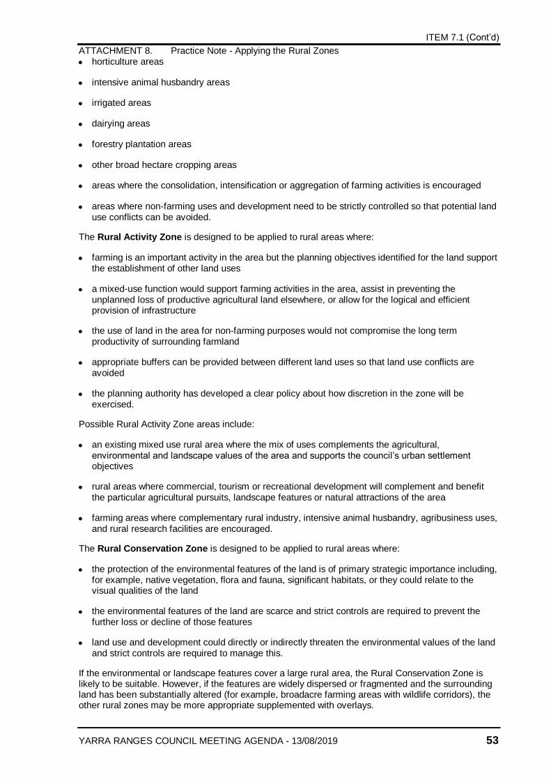
ITEM 7.1 (Cont’d)
ATTACHMENT 8. Practice Note - Applying the Rural Zones
YARRA RANGES COUNCIL MEETING AGENDA - 13/08/2019 53
horticulture areas
intensive animal husbandry areas
irrigated areas
dairying areas
forestry plantation areas
other broad hectare cropping areas
areas where the consolidation, intensification or aggregation of farming activities is encouraged
areas where non-farming uses and development need to be strictly controlled so that potential land use conflicts can be avoided.
The Rural Activity Zone is designed to be applied to rural areas where:
farming is an important activity in the area but the planning objectives identified for the land support the establishment of other land uses
a mixed-use function would support farming activities in the area, assist in preventing the unplanned loss of productive agricultural land elsewhere, or allow for the logical and efficient provision of infrastructure
the use of land in the area for non-farming purposes would not compromise the long term productivity of surrounding farmland
appropriate buffers can be provided between different land uses so that land use conflicts are avoided
the planning authority has developed a clear policy about how discretion in the zone will be exercised.
Possible Rural Activity Zone areas include:
an existing mixed use rural area where the mix of uses complements the agricultural, environmental and landscape values of the area and supports the council’s urban settlement objectives
rural areas where commercial, tourism or recreational development will complement and benefit the particular agricultural pursuits, landscape features or natural attractions of the area
farming areas where complementary rural industry, intensive animal husbandry, agribusiness uses, and rural research facilities are encouraged.
The Rural Conservation Zone is designed to be applied to rural areas where:
the protection of the environmental features of the land is of primary strategic importance including, for example, native vegetation, flora and fauna, significant habitats, or they could relate to the visual qualities of the land
the environmental features of the land are scarce and strict controls are required to prevent the further loss or decline of those features
land use and development could directly or indirectly threaten the environmental values of the land and strict controls are required to manage this.
If the environmental or landscape features cover a large rural area, the Rural Conservation Zone is likely to be suitable. However, if the features are widely dispersed or fragmented and the surrounding land has been substantially altered (for example, broadacre farming areas with wildlife corridors), the other rural zones may be more appropriate supplemented with overlays.
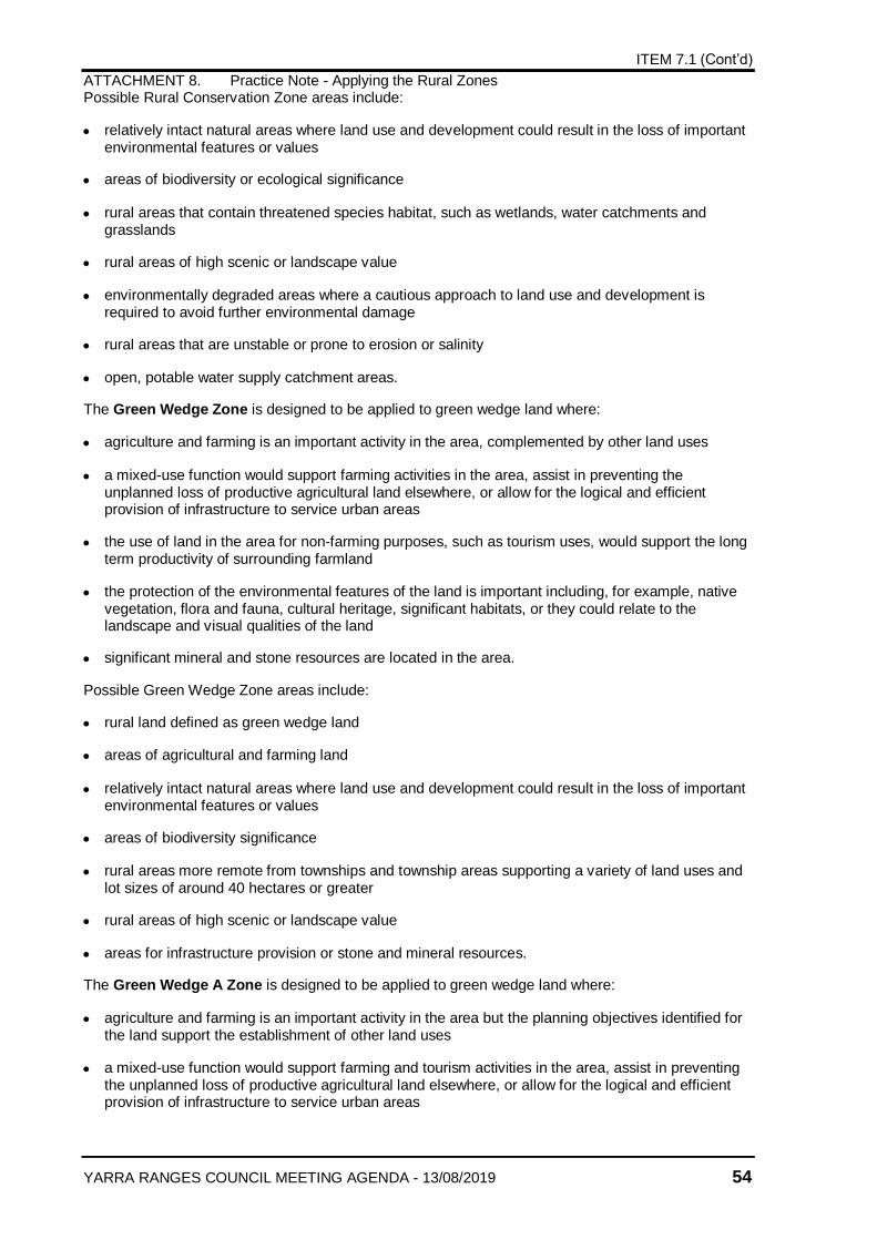
ITEM 7.1 (Cont’d)
ATTACHMENT 8. Practice Note - Applying the Rural Zones
YARRA RANGES COUNCIL MEETING AGENDA - 13/08/2019 54
Possible Rural Conservation Zone areas include:
relatively intact natural areas where land use and development could result in the loss of important environmental features or values
areas of biodiversity or ecological significance
rural areas that contain threatened species habitat, such as wetlands, water catchments and grasslands
rural areas of high scenic or landscape value
environmentally degraded areas where a cautious approach to land use and development is required to avoid further environmental damage
rural areas that are unstable or prone to erosion or salinity
open, potable water supply catchment areas.
The Green Wedge Zone is designed to be applied to green wedge land where:
agriculture and farming is an important activity in the area, complemented by other land uses
a mixed-use function would support farming activities in the area, assist in preventing the unplanned loss of productive agricultural land elsewhere, or allow for the logical and efficient provision of infrastructure to service urban areas
the use of land in the area for non-farming purposes, such as tourism uses, would support the long term productivity of surrounding farmland
the protection of the environmental features of the land is important including, for example, native vegetation, flora and fauna, cultural heritage, significant habitats, or they could relate to the landscape and visual qualities of the land
significant mineral and stone resources are located in the area.
Possible Green Wedge Zone areas include:
rural land defined as green wedge land
areas of agricultural and farming land
relatively intact natural areas where land use and development could result in the loss of important environmental features or values
areas of biodiversity significance
rural areas more remote from townships and township areas supporting a variety of land uses and lot sizes of around 40 hectares or greater
rural areas of high scenic or landscape value
areas for infrastructure provision or stone and mineral resources.
The Green Wedge A Zone is designed to be applied to green wedge land where:
agriculture and farming is an important activity in the area but the planning objectives identified for the land support the establishment of other land uses
a mixed-use function would support farming and tourism activities in the area, assist in preventing the unplanned loss of productive agricultural land elsewhere, or allow for the logical and efficient provision of infrastructure to service urban areas
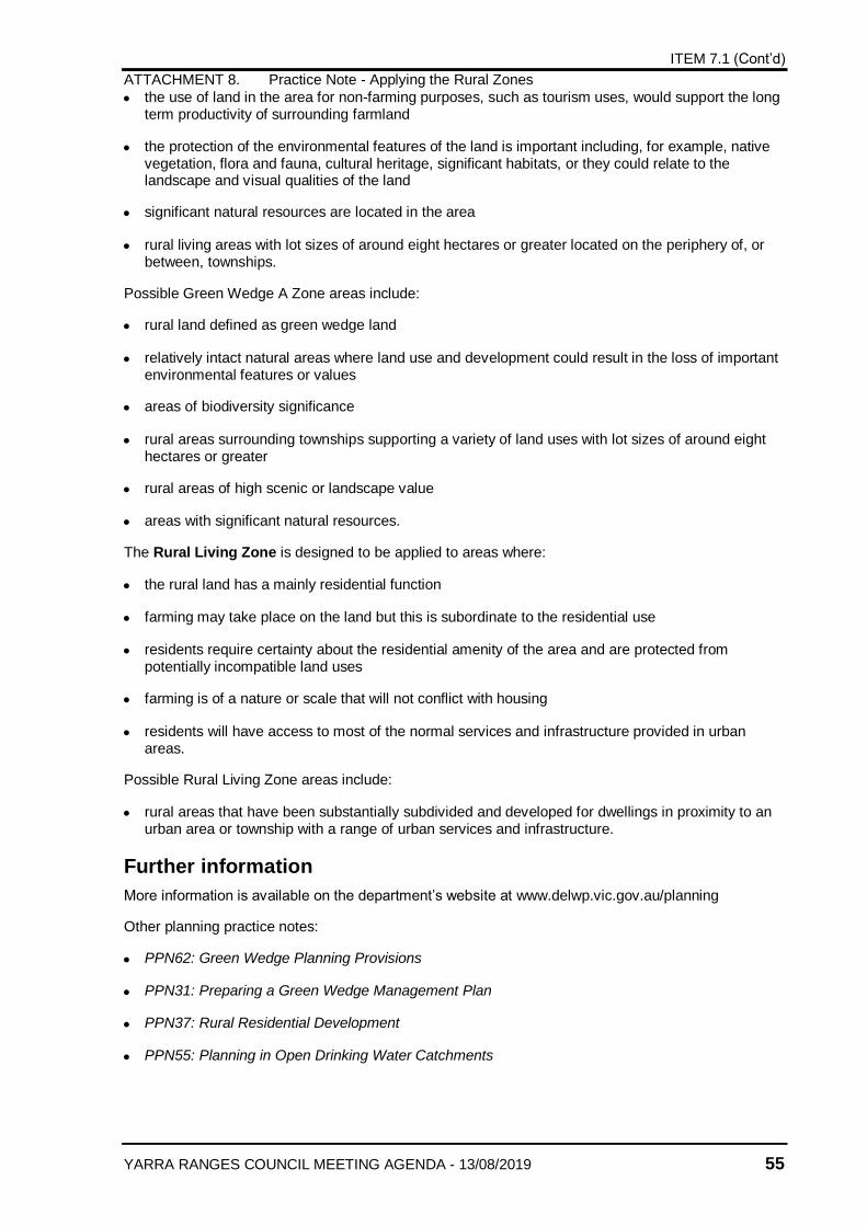
ITEM 7.1 (Cont’d)
ATTACHMENT 8. Practice Note - Applying the Rural Zones
YARRA RANGES COUNCIL MEETING AGENDA - 13/08/2019 55
the use of land in the area for non-farming purposes, such as tourism uses, would support the long term productivity of surrounding farmland
the protection of the environmental features of the land is important including, for example, native vegetation, flora and fauna, cultural heritage, significant habitats, or they could relate to the landscape and visual qualities of the land
significant natural resources are located in the area
rural living areas with lot sizes of around eight hectares or greater located on the periphery of, or between, townships.
Possible Green Wedge A Zone areas include:
rural land defined as green wedge land
relatively intact natural areas where land use and development could result in the loss of important environmental features or values
areas of biodiversity significance
rural areas surrounding townships supporting a variety of land uses with lot sizes of around eight hectares or greater
rural areas of high scenic or landscape value
areas with significant natural resources.
The Rural Living Zone is designed to be applied to areas where:
the rural land has a mainly residential function
farming may take place on the land but this is subordinate to the residential use
residents require certainty about the residential amenity of the area and are protected from potentially incompatible land uses
farming is of a nature or scale that will not conflict with housing
residents will have access to most of the normal services and infrastructure provided in urban areas.
Possible Rural Living Zone areas include:
rural areas that have been substantially subdivided and developed for dwellings in proximity to an urban area or township with a range of urban services and infrastructure.
Further information
More information is available on the department’s website at www.delwp.vic.gov.au/planning
Other planning practice notes:
PPN62: Green Wedge Planning Provisions
PPN31: Preparing a Green Wedge Management Plan
PPN37: Rural Residential Development
PPN55: Planning in Open Drinking Water Catchments
ITEM 7.1 (Cont’d)
ATTACHMENT 8. Practice Note - Applying the Rural Zones
YARRA RANGES COUNCIL MEETING AGENDA - 13/08/2019 56
© The State of Victoria Department of Environment, Land, Water and Planning 2015
This work is licensed under a Creative Commons Attribution 4.0 International licence. You are free to re-use the work under that licence, on the condition that you credit the State of Victoria as author. The licence does not apply to any images, photographs or branding, including the Victorian Coat of Arms, the Victorian Government logo and the Department of Environment, Land, Water and Planning (DELWP) logo. To view a copy of this licence, visit http://creativecommons.org/licenses/by/4.0/
Published November 2013, republished June 2015 ISBN 978-1-922250-13-1
Disclaimer
This publication may be of assistance to you but the State of Victoria and its employees do not guarantee that the publication is without flaw of any kind or is wholly appropriate for your particular purposes and therefore disclaims all liability for any error, loss or other consequence which may arise from you relying on any information in this publication.
Accessibility
If you would like to receive this publication in an alternative format, please telephone DELWP Customer Service Centre 136 186, email [email protected], via the National Relay Service on 133 677 www.relayservice.com.au . This document is also available in accessible Word format at www.delwp.vic.gov.au/planning
DOCUMENT ENDS
ITEM 7.1
ATTACHMENT 9. CFA Guideline for Assessing the BMO
YARRA RANGES COUNCIL MEETING AGENDA - 13/08/2019 57
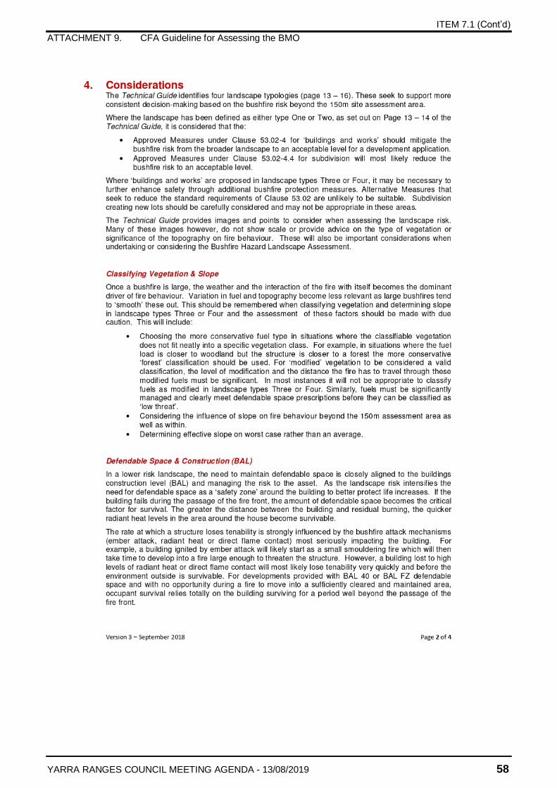
ITEM 7.1 (Cont’d)
ATTACHMENT 9. CFA Guideline for Assessing the BMO
YARRA RANGES COUNCIL MEETING AGENDA - 13/08/2019 58
ITEM 7.1 (Cont’d)
ATTACHMENT 9. CFA Guideline for Assessing the BMO
YARRA RANGES COUNCIL MEETING AGENDA - 13/08/2019 59
ITEM 7.1 (Cont’d)
ATTACHMENT 9. CFA Guideline for Assessing the BMO
YARRA RANGES COUNCIL MEETING AGENDA - 13/08/2019 60
ITEM 7.1
ATTACHMENT 10.O'Toole v Yarra Ranges SC 2018
YARRA RANGES COUNCIL MEETING AGENDA - 13/08/2019 61
ITEM 7.1 (Cont’d)
ATTACHMENT 10. O'Toole v Yarra Ranges SC 2018
YARRA RANGES COUNCIL MEETING AGENDA - 13/08/2019 62
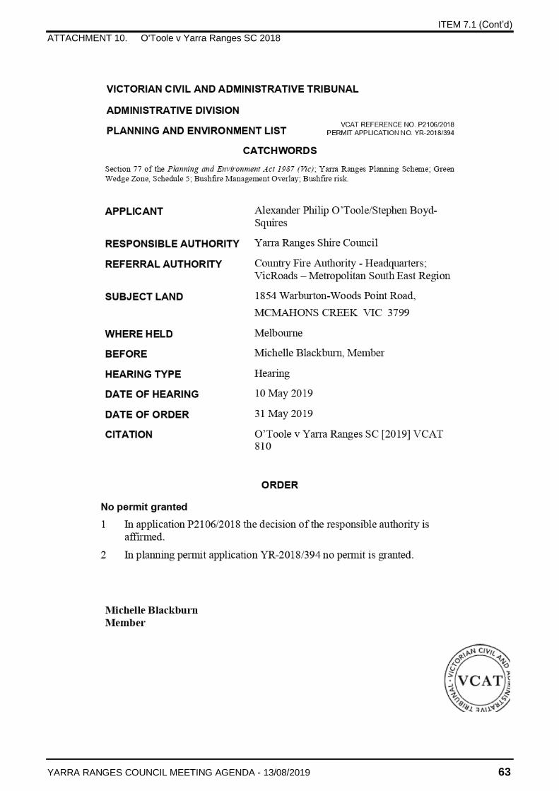
ITEM 7.1 (Cont’d)
ATTACHMENT 10. O'Toole v Yarra Ranges SC 2018
YARRA RANGES COUNCIL MEETING AGENDA - 13/08/2019 63
ITEM 7.1 (Cont’d)
ATTACHMENT 10. O'Toole v Yarra Ranges SC 2018
YARRA RANGES COUNCIL MEETING AGENDA - 13/08/2019 64
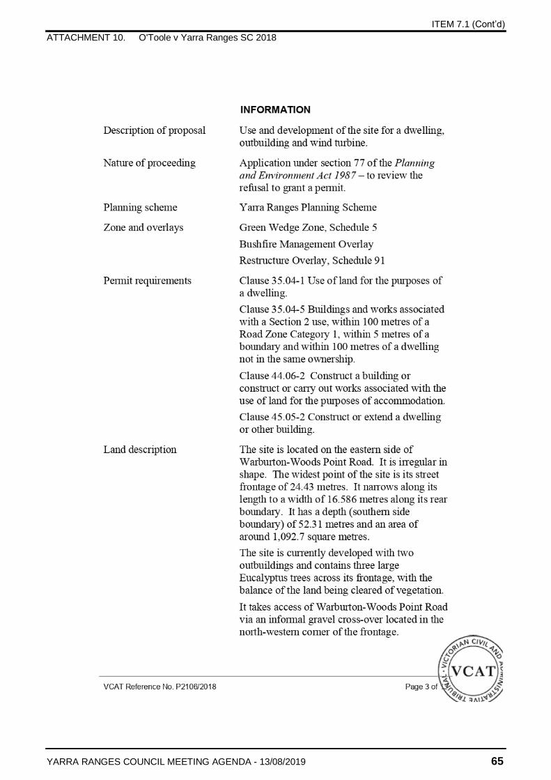
ITEM 7.1 (Cont’d)
ATTACHMENT 10. O'Toole v Yarra Ranges SC 2018
YARRA RANGES COUNCIL MEETING AGENDA - 13/08/2019 65
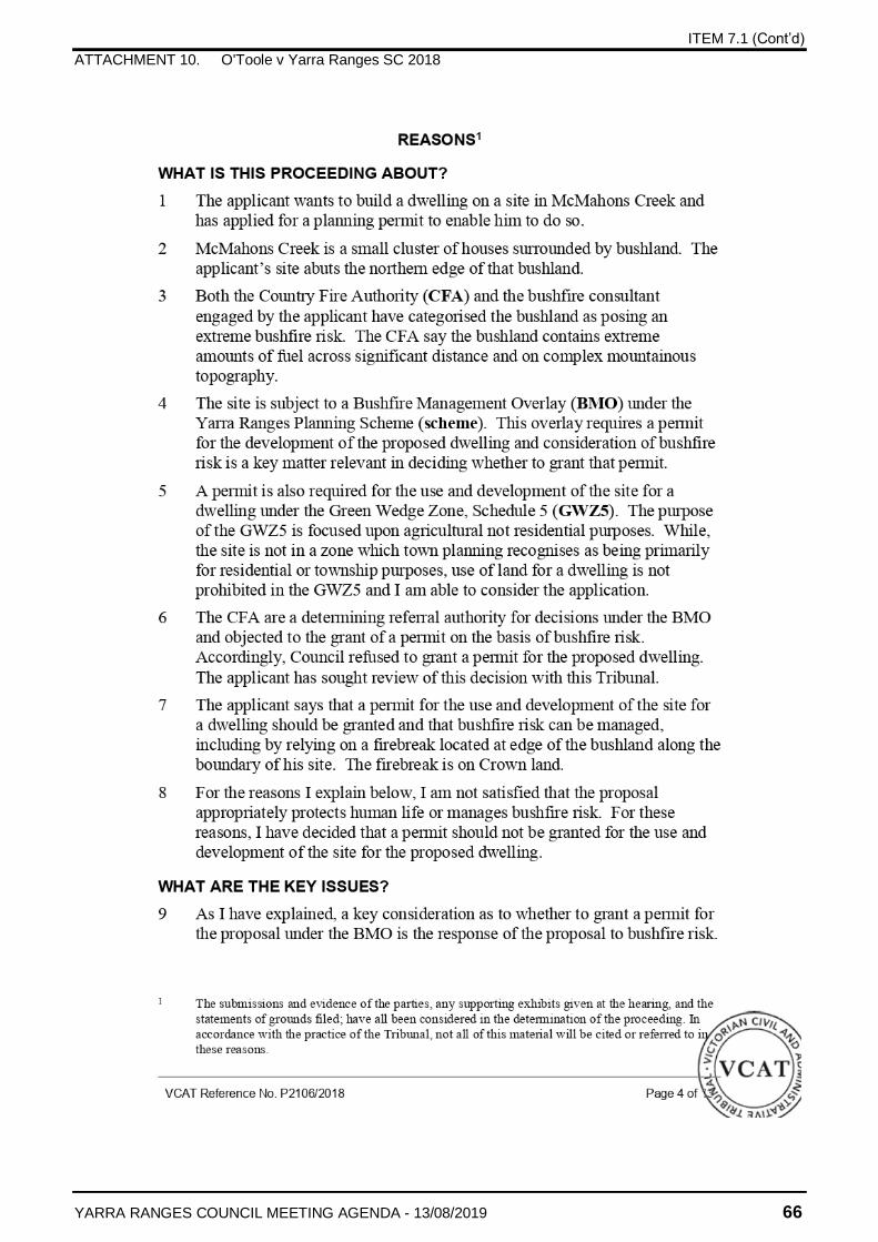
ITEM 7.1 (Cont’d)
ATTACHMENT 10. O'Toole v Yarra Ranges SC 2018
YARRA RANGES COUNCIL MEETING AGENDA - 13/08/2019 66
ITEM 7.1 (Cont’d)
ATTACHMENT 10. O'Toole v Yarra Ranges SC 2018
YARRA RANGES COUNCIL MEETING AGENDA - 13/08/2019 67
ITEM 7.1 (Cont’d)
ATTACHMENT 10. O'Toole v Yarra Ranges SC 2018
YARRA RANGES COUNCIL MEETING AGENDA - 13/08/2019 68
ITEM 7.1 (Cont’d)
ATTACHMENT 10. O'Toole v Yarra Ranges SC 2018
YARRA RANGES COUNCIL MEETING AGENDA - 13/08/2019 69
ITEM 7.1 (Cont’d)
ATTACHMENT 10. O'Toole v Yarra Ranges SC 2018
YARRA RANGES COUNCIL MEETING AGENDA - 13/08/2019 70
ITEM 7.1 (Cont’d)
ATTACHMENT 10. O'Toole v Yarra Ranges SC 2018
YARRA RANGES COUNCIL MEETING AGENDA - 13/08/2019 71
ITEM 7.1 (Cont’d)
ATTACHMENT 10. O'Toole v Yarra Ranges SC 2018
YARRA RANGES COUNCIL MEETING AGENDA - 13/08/2019 72
ITEM 7.1 (Cont’d)
ATTACHMENT 10. O'Toole v Yarra Ranges SC 2018
YARRA RANGES COUNCIL MEETING AGENDA - 13/08/2019 73
ITEM 7.1 (Cont’d)
ATTACHMENT 10. O'Toole v Yarra Ranges SC 2018
YARRA RANGES COUNCIL MEETING AGENDA - 13/08/2019 74
ITEM 7.1 (Cont’d)
ATTACHMENT 10. O'Toole v Yarra Ranges SC 2018
YARRA RANGES COUNCIL MEETING AGENDA - 13/08/2019 75
ITEM 7.2
YARRA RANGES COUNCIL MEETING AGENDA - 13/08/2019 76
CORPORATE SERVICES No. of Pages – 3
7.2 CT5869 Provision of IT Products and Services
RESPONSIBLE OFFICER Acting Director Corporate Services
SUMMARY
Yarra Ranges Council nominated Procurement Australia as its agent to facilitate a public tender for the provision of IT Products & Services as allowed under Part 5(b) of Section 186 of the Local Government Act 1989.
The proposed contract (2106/0712) commenced on 1 July 2019 until 30 June 2021 with an option to extend for a further twelve months. This contract replaces CT5164 (1806/0711) which expired on 30 June 2019.
This contract will be utilised on an as required basis for the procurement of IT products and services, including (but not limited to):
network consultancy services
software licencing
purchase of hardware (ie monitors, keyboards, telephone equipment etc)
server componentry (although this is likely to decrease as we move to a cloud-based environment).
It is also anticipated that this panel will be utilised for the acquisition of leased hardware assets during the device refresh later this year. The estimated cost for this is approximately $1,200,000 over three years.
To ensure best value outcomes from the Panel arrangement, Council will seek multiple quotations from the panel where appropriate
The Tender Evaluation Panel comprising the Manager, Information Services, Executive Officer, Information Services and Executive Officer, Strategic Procurement Services, recommend the acceptance of the Procurement Australia contract to appoint a panel of suppliers across ten relevant IT categories.
This item has been included in the public agenda to facilitate openness and transparency in Council’s decision making. A confidential attachment has been included with the report which contains commercially sensitive information that is not to be disclosed whilst the meeting is open to the public.
RECOMMENDATION
That:
1. Council accepts the Procurement Australia tender recommendation for IT Products & Services Panel (Contract No. 2106/0712), for a period of two years commencing 1 July 2019 with an option to extend.
ITEM 7.2 (Cont’d)
YARRA RANGES COUNCIL MEETING AGENDA - 13/08/2019 77
2. Any contract documents be signed.
3. This report and its attachments remain confidential under Section 89(2) of the Local Government Act 1989 as it contains information relating to: (d) contractual matter.
DISCLOSURE OF CONFLICTS OF INTEREST
All members of the Tender evaluation panel signed the conflict of interest declarations. None of the members declared any actual, perceived or potential conflict of interest.
PROPOSAL
To accept Procurement Australia’s recommendation to engage a panel of providers for the provision of IT Products & Services.
BACKGROUND
Procurement Australia placed an advertisement calling for tenders in the Sydney Morning Herald newspaper on Tuesday, 9 April 2019 and the Herald Sun on Wednesday, 10 April 2019 to form a Panel to deliver a range of IT Products & Services. The Panel includes ten categories, as follows.
Category 1: IT Hardware
Category 2: IT Software
Category 3: Mobile IT Devices
Category 4: Hosting/Cloud Services
Category 5: IT Infrastructure (including Networking and Storage)
Category 6: IT Services (including Leasing)
Category 7: Business Telephone Systems & Services
Category 8: IT Disposals
Category 9: Cyber Security Solutions and Services
Category 10: Member Specific Requirements.
This panel replaces Contract No. CT5164 PA (1806/0711) Provision of IT Products & Services which expired on 30 June 2019. Council spent $1,525,722 (including GST) throughout the three year term of this contract, across a number of suppliers.
Tenders closed at 3pm AEST on Wednesday, 8 May 2019, and a total of 43 submissions were received.
ITEM 7.2 (Cont’d)
YARRA RANGES COUNCIL MEETING AGENDA - 13/08/2019 78
Of the 43 submissions, 31 were deemed suitable to provide products and services under the Panel arrangement. For a detailed summary of the evaluation, please refer to Attachment 1 (Procurement Australia Evaluation Report).
STRATEGIC LINKS
This new panel contract will assist Council to continue to develop and progress its Information Technology (IT) plans linked to the Flexible Future Project and the future in an efficient and cost effective manner.
CONSULTATION
Council’s IT department has been involved in this process to ensure that it meets the Council’s needs.
FINANCIAL IMPLICATIONS
Future spends for this contract will be funded from within the agreed IT operational budget.
KEY ISSUES
Environmental Impacts
This has been considered as part of the evaluation process.
Social Impacts
Social Responsibility was considered as part of the evaluation process.
Economic Impacts
The IT department will consider the advantages of supporting panel suppliers that may be based locally and/or that support local economy when assessing quotations on an as required basis.
Risk Assessment
This has been considered as part of the evaluation process.
CONCLUSION
That Council adopts the recommendations within this report.
ATTACHMENTS
1 Procurement Australia Evaluation Report (Confidential)
ITEM 7.3
YARRA RANGES COUNCIL MEETING AGENDA - 13/08/2019 79
ENVIRONMENT AND ENGINEERING
No. of Pages – 4
7.3 CT5897 - Tree Pruning and Associated Services (Collaborative Project)
RESPONSIBLE OFFICER Director Environment and Engineering
SUMMARY
This project was identified as a collaborative procurement opportunity through the Eastern Region Procurement Network.
In 2019 eight (8) Councils engaged in a collaborative approach for the provision of Tree Pruning and Associated Services Council included; Manningham City Council, Banyule City Council, City of Greater Dandenong Council, Monash City Council, Moreland City Council, Nillumbik Shire Council, Whitehorse City Council, and Yarra Ranges Council.
In accordance with Part 5 of Section 186 of the Local Government Act, all the participating Councils appointed Manningham City Council as the Agent for this tender.
The collaborative tender was advertised in the Age newspaper on 3 April 2019 and closed on 8 May 2019.
A total of twenty eight (28) submissions were received from tenderers.
The Evaluation Panel representing Yarra Ranges Council recommends the tender from Active Tree Services Pty Ltd be accepted for a lump sum amount of $685,360.00 exclusive of GST ($753,896.00 inclusive of GST) for the first year of the contract with CPI adjustment for each subsequent year.
This item has been included in the public agenda to facilitate openness and transparency in Council’s decision making. A confidential attachment has been included with the report which contains commercially sensitive information that is not to be disclosed whilst the meeting is open to the public.
RECOMMENDATION
That
1. Council awards the tender from Active Tree Services Pty Ltd for CT5897 for provision of Block Street Tree Pruning Services with a total estimated six (6) year contract value of $4,214,964.00 excluding GST, ($4,636,460.40 inclusive GST).
2. The contract be for an initial term starting 14 August 2019 and ending 13 August 2020 having a first year total lump sum price of $685,360.00 exclusive of GST ($753,896.00 inclusive of GST) with future year prices subject to CPI indexation in accordance with the contract.
ITEM 7.3 (Cont’d)
YARRA RANGES COUNCIL MEETING AGENDA - 13/08/2019 80
3. The contract have the option for two (2) further extensions at Council’s discretion subject to satisfactory performance of:
(a) a two (2) year period, and then
(b) a further three (3) year period.
4. The Director of Environment & Engineering be delegated authority to sign the contract documents.
5. The Director Environment & Engineering be delegated authority to extend the contract by a two year period and then a further three year period on the terms set out in the original contract.
6. The confidential attachment to this report remain confidential indefinitely as it relates to matters specified under section 89(2)(d) of the Local Government Act 1989.
DISCLOSURE OF CONFLICTS OF INTEREST
All members of the Tender evaluation panel signed the conflict of interest declarations. None of the members declared any actual, perceived or potential conflict of interest.
PROPOSAL
To seek Council approval to award the contract as recommended.
BACKGROUND
The Eastern Region Procurement Network identified Tree Services has a large spend category and consolidated a collaborative tender process and in 2015 five (5) Councils issued a collaborative tender for Tree Pruning and other Associated Services. The contract was for three (3) years ending 30 June 2019.
In 2019 a new collaborative tender process was initiated and Manningham City Council was appointed by the other Councils to act as their agent (and on its own behalf) for the purposes of conducting this tender for the Services.
A services specification was developed jointly by representatives of the participating councils, with the assistance of a consulting arborist.
Block pruning services were to be priced on a Lump Sum basis, and non-programmed and reactive services on a schedule of rates basis.
The tender schedules included provision for tenderers to offer a lump sum discount if they were selected by two or more councils.
Each participating Council will enter into individual contracts for the provision of the Services on its own behalf.
ITEM 7.3 (Cont’d)
YARRA RANGES COUNCIL MEETING AGENDA - 13/08/2019 81
Due to the participating Councils having existing contracts with different expiry dates, each of the participating Councils will require the delivery of the Services to start at different specific dates. The successful tenderers will need to be prepared for service transition with each participating Council at the dates nominated in the Specification.
After a collaborative review of the tenderer submissions it was determined that only two (2) tenderers provided lump sum pricing for Block Tree Pruning Services relevant to Yarra Ranges Council.
STRATEGIC LINKS
By recommending suppliers that present a best value outcome, this report supports Council’s strategy for long term financial sustainability.
CONSULTATION
Council’s Tree Operations Supervisor and Tree Coordinator were involved in the formulation of the collaborative service specification and the resulting tender evaluation process.
FINANCIAL IMPLICATIONS
As part of the collaborative procurement tender, Active Tree Services Pty Ltd is offering services valued at $685,360.00 per annum excluding GST.
Assuming an annual 1.65% CPI (based on recent July 2018 to June 2019 data) across the life of the proposed contract, the estimated total value of this contract is $4,214,964.00 excluding GST (over 6 years).
KEY ISSUES
This tender process has been carried out in accordance with the requirements of Council's Procurement Policy.
Tenders were assessed for conformity with the tender documents and no tenders were eliminated from further evaluation as a result of major non-conformances.
Confidential information is contained in Attachment 1. This information relates to contractual matters and contains commercially sensitive information including, but not limited to, the name of tendering parties, the evaluation panel members, the tendered prices and the evaluation of the tenders received against the published evaluation criteria.
Any disclosure of the information included within the confidential attachment to this report could be prejudicial to the interests of the Council or other parties. If discussion of this information is required, the Council is recommended to resolve that the item be deferred to the confidential section of the agenda when the meeting is closed to members of the public in accordance with Section 89(2) of the Local Government Act 1989.
This report seeks Council approval to award a contract that complies with the Section 186 of the Local Government Act 1989.
ITEM 7.3 (Cont’d)
YARRA RANGES COUNCIL MEETING AGENDA - 13/08/2019 82
Environmental Impacts
There are no environmental impacts directly associated with this report.
Social Impacts
There are no social impacts directly associated with this report.
Economic Impacts
There are no economic impacts directly associated with this report.
Risk Assessment
This has been considered as part of the project design, contract terms and conditions and the evaluation process.
CONCLUSION
That Council adopts the recommendations within this report.
ATTACHMENTS
1 CT5897 Block Street Tree Pruning Evaluation Report (Confidential)
ITEM 7.4
YARRA RANGES COUNCIL MEETING AGENDA - 13/08/2019 83
No. of Pages – 6
7.4 Biodiversity Offsets Program (BOP): Price Amendments
RESPONSIBLE OFFICER Director Environment and Engineering
SUMMARY
The Yarra Ranges Biodiversity Offsets Program has been developed to provide strategic and proactive vegetation offsets that can be purchased by permit applicants to streamline the offsetting process and achieve quality ecological outcomes locally.
The Biodiversity Offsets Program operates within the state-wide offset market which experienced significant reforms in 2013 and then again in December 2017. In response to the reforms the Biodiversity Offsets Program costing model was significantly adjusted in June 2018 to enable the program to trade in the new offset units (general habitat units (GHU) and species habitat units (SHU)). While the model has changed significantly, it has been maintained as a cost recovery model only.
The Biodiversity Offsets Program is successfully trading in general habitat units (GHU). The current Biodiversity Offsets Program price for general offsets (GHU) is trending high in comparison to average state data. It is recommended that the price for these units is reduced by 4.6% to $135,000 per GHU to enable the Biodiversity Offsets Program to provide a more competitive and fair price to local residents and for Council’s own civil works.
A review of the Biodiversity Offsets Program threatened species offsets (SHU) has identified that the complex trading mechanism of these units was internally misinterpreted resulting in a price that was not reflective of the costing model set. It is recommended that the threatened species unit price is increased and corrected to $146,000 per SHU. No trades have occurred in these units to date at the incorrect price.
The current offset market is still immature and prices vary significantly. Streamlining the price approval process will enable the Biodiversity Offsets Program greater flexibility to respond to state market trends and improve the ability to achieve cost recovery within the final remaining 3 years of the program as originally planned. It is recommended that the CEO is given authority to approve future price changes for the Biodiversity Offsets Program.
RECOMMENDATION
That
1. The Biodiversity Offsets Program prices are amended to:
a) $135,000 per General Habitat Unit (GHU),
b) $146,000 per Species Habitat Unit (SHU).
2. The Chief Executive Officer is authorised to approve future price changes for the Biodiversity Offset Program.
ITEM 7.4 (Cont’d)
YARRA RANGES COUNCIL MEETING AGENDA - 13/08/2019 84
DISCLOSURE OF CONFLICTS OF INTEREST
The author of this report does not have a conflict of interest.
PROPOSAL
The Biodiversity Offsets Program is successfully trading in general habitat units (GHU). Compared to state market trends the Biodiversity Offsets Program price for general offsets (GHU) is at the more expensive end of the current market averages. It is recommended that the price is reduced by 4.6% to $135,000 per GHU to enable the Biodiversity Offsets Program to provide a more competitive price to local residents and for Council’s own civil works. A price reduction is likely to have a positive impact on the program’s cost recovery model by increasing the volume of offsets that are likely to be traded over the final remaining 3 years of the program.
A review of the Biodiversity Offsets Program threatened species offsets (SHU) has identified that the complex trading mechanism of these units was internally misinterpreted resulting in a price that was not reflective of the costing model set. Trading at the current set price of $71,000 per SHU would result in the program running at a financial loss, would significantly undermine market prices, and would fail to demonstrate competitive neutrality. No trades have occurred in the new threatened species units and any current enquiries have been frozen until the price has been corrected. It is recommended that threatened species unit price is corrected to $146,000 per SHU.
The current offset market is still immature and prices vary significantly. Current data for general offsets (GHU) indicate that the Biodiversity Offsets Program prices are high and there is insufficient market data for threatened species offsets (SHU). Streamlining the price approval process will enable the Biodiversity Offsets Program greater flexibility to respond to state market trends and improve the program’s ability to achieve cost recovery within the final remaining 3 years. It is recommended that the CEO is given authority to approve future price changes for the Biodiversity Offsets Program.
BACKGROUND
The Yarra Ranges Biodiversity Offsets Program has been developed to provide strategic and proactive vegetation offsets that can be purchased by permit applicants to streamline the offsetting process and achieve quality ecological outcomes.
The Biodiversity Offsets Program facilitates the local implementation of existing State policy and legislation including the Guidelines for the removal, destruction or lopping or native vegetation (DELWP, 2017). A key strategy identified by the State Planning Policy Framework (in particular Clause 12.01 Biodiversity) is to ensure that there is no net loss to biodiversity as a result of the removal, destruction or lopping of native vegetation through avoiding, minimising and offsetting impacts.
The Biodiversity Offsets Program provides an option to assist permit holders to meet their vegetation offset requirements. The four main goals of the Biodiversity Offsets Program are:
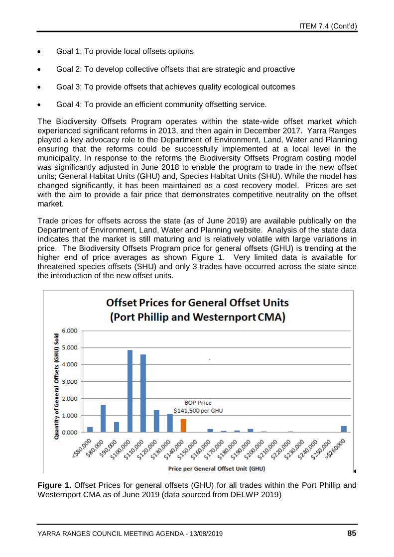
ITEM 7.4 (Cont’d)
YARRA RANGES COUNCIL MEETING AGENDA - 13/08/2019 85
Goal 1: To provide local offsets options
Goal 2: To develop collective offsets that are strategic and proactive
Goal 3: To provide offsets that achieves quality ecological outcomes
Goal 4: To provide an efficient community offsetting service.
The Biodiversity Offsets Program operates within the state-wide offset market which experienced significant reforms in 2013, and then again in December 2017. Yarra Ranges played a key advocacy role to the Department of Environment, Land, Water and Planning ensuring that the reforms could be successfully implemented at a local level in the municipality. In response to the reforms the Biodiversity Offsets Program costing model was significantly adjusted in June 2018 to enable the program to trade in the new offset units; General Habitat Units (GHU) and, Species Habitat Units (SHU). While the model has changed significantly, it has been maintained as a cost recovery model. Prices are set with the aim to provide a fair price that demonstrates competitive neutrality on the offset market.
Trade prices for offsets across the state (as of June 2019) are available publically on the Department of Environment, Land, Water and Planning website. Analysis of the state data indicates that the market is still maturing and is relatively volatile with large variations in price. The Biodiversity Offsets Program price for general offsets (GHU) is trending at the higher end of price averages as shown Figure 1. Very limited data is available for threatened species offsets (SHU) and only 3 trades have occurred across the state since the introduction of the new offset units.
Figure 1. Offset Prices for general offsets (GHU) for all trades within the Port Phillip and
Westernport CMA as of June 2019 (data sourced from DELWP 2019)

ITEM 7.4 (Cont’d)
YARRA RANGES COUNCIL MEETING AGENDA - 13/08/2019 86
STRATEGIC LINKS
The Biodiversity Offsets Program supports Council Plan objectives in protecting and enhancing the natural environment and managing our significant natural capital. Council’s active involvement and strong advocacy to the Native Vegetation Regulations review has further enhanced our credibility at DELWP, whilst strongly supporting the intent of Council’s Environment Strategy.
CONSULTATION
Following the gazetting of the regulations by DELWP (Department of Environment, Land, Water and Planning) in December 2017, the Biodiversity team have consulted with a number of clients, organisations and consultancies involved in the biodiversity assessment and offset space in order to develop a good understanding of the market. Trade prices across Victoria are available publically on the DELWP website and this data is being closely monitored to test how current Biodiversity Offsets Program prices compare on the market.
FINANCIAL IMPLICATIONS
The Biodiversity Offset Program prices were developed using a cost recovery model with the aim to participate fairly in the state-wide offset market and to demonstrate competitive neutrality. During the 2018-19 financial year the Biodiversity Offsets Program traded $98,044 worth of offsets which covered the operating costs for the year and has reduced the programs accumulated debt. The Biodiversity Offsets Program is well positioned to achieve overall cost recovery by 2022 as originally planned.
Compared to state market trends the Biodiversity Offsets Program price for general offsets (GHU) is at the more expensive end of current market averages. It is recommended that the price for general offsets is reduced by 4.6% to (from $141,500 to $135,000 per GHU) to enable the Biodiversity Offsets Program to provide a more competitive and fair market price to local residents and for Council’s own civil works. A price reduction is likely to have a positive impact on the program’s cost recovery model by increasing the volume of offsets traded over the final remaining 3 years.
The current price of $71,000 per SHU is under-priced and does not reflect the Biodiversity Offsets Program cost recovery model. Trading at the current set price of $71,000 per SHU would result in the Biodiversity Offsets Program running at a financial loss, would significantly undermine the state market prices, and would fail to demonstrate competitive neutrality. No trades have occurred in SHU and any current enquiries have been frozen until the price has been corrected. It is recommended that threatened species offset price is corrected to $146,000.
Note that the costing model for the Biodiversity Offsets Program includes CPI and the price set for offset units is not be subject to annual CPI increases.
ITEM 7.4 (Cont’d)
YARRA RANGES COUNCIL MEETING AGENDA - 13/08/2019 87
KEY ISSUES
The State Government amendments to Native Vegetation Regulations have provided the opportunity for Biodiversity Offsets Program to be a strong participant in providing offsets in the region. This has increased the ability for cost recovery of the program. The program continues to provide a service to the Yarra Ranges Community ensuring that local offsets are available and that offsets achieve quality ecological outcomes. All Council works requiring vegetation removal as part of a Planning Permit or under the Code of Environmental Practice can be met locally.
Environmental Impacts
The Biodiversity Program provides in perpetuity protection and resources a high quality of management for significant environmental assets within the municipality. The program provides the facility for offset requirements to be achieved within the municipality rather than elsewhere in the region. This supports the principles of Council’s Environment Strategy.
Social Impacts
The proposals in this report will enable the Biodiversity Offset Program to continue to provide timely, efficient and competitive service to assist planning applicants with their offset requirements. This services both residents of Yarra Ranges through provision of a service and retaining investment in biodiversity protection within the municipality.
During the 2018-2019 financial year the Biodiversity Offsets Program has successfully facilitated 14 offset trades and has generated 44 quotes to permit holders seeking offsets within the Yarra Ranges and surrounding municipalities.
Economic Impacts
The latest revised regulations have significantly improved the value of the Biodiversity Offsets Program assets, enabling more cost effective offsets in the municipality. Council’s own offset requirements can continue to be processed through Biodiversity Offsets Program, and therefore the majority of the funds will not leave the municipality.
It is important that the Biodiversity Offsets Program competes fairly on the offset market and demonstrates competitive neutrality. The Biodiversity Offsets Program prices for offsets are closely monitored by other offset providers and play an important role in setting and stabilising the state offset market.
The current Biodiversity Offsets Program price for general offsets (GHU) is trending high in comparison to average state data. A price reduction of 4.6% is likely to increase the programs ability to trade fairly and competitively while still achieving cost recovery.
It is important that the threatened species unit price is corrected to $146,000 per SHU. Trading under-priced at $71,000 per SHU would result in the program running at a financial loss, would significantly undermine the market prices, and would fail to demonstrate competitive neutrality.
ITEM 7.4 (Cont’d)
YARRA RANGES COUNCIL MEETING AGENDA - 13/08/2019 88
Risk Assessment
Following the re-election of the State Government in November 2018, it is considered highly unlikely that changes to the native vegetation regulations will occur over the remainder of the program lifespan.
It is important the Biodiversity Offsets Program remains responsive to state market trends to continue to provide a competitive and fair offset price to customers and to achieve cost recovery of the program.
CONCLUSION
The current Biodiversity Offsets Program price for general offsets (GHU) is trending high in comparison to average state data. It is recommended that the price for these units is reduced by 4.6% to $135,000 per GHU to enable the Biodiversity Offsets Program to provide a more competitive and fair price to local residents and for Yarra Ranges Council civil works. A price reduction is likely to have a positive impact on the programs cost recovery model by increasing the volume of offsets we are likely to trade over the final remaining 3 years.
The current price for threatened species offsets at $71,000 per SHU is under-priced and does not reflect the Biodiversity Offsets Program cost recovery model. Trading at $71,000 per SHU would result in the Biodiversity Offsets Program running at a financial loss, would significantly undermine the state market prices and would fail to demonstrate competitive neutrality. No trades have occurred in SHU and any current enquiries have been frozen until the price has been corrected. It is recommended that threatened species offset price is corrected to $146,000.
The current offset market is still immature and prices vary significantly. Streamlining the price approval process will enable the program greater flexibility to respond to state market trends and improve the programs ability to achieve cost recovery within the next 3 years. It is recommended that the CEO is given authority to approve future price changes for the Biodiversity Offsets Program.
ATTACHMENTS
There are no attachments to this report.
YARRA RANGES COUNCIL MEETING AGENDA - 13/08/2019 89
8. COUNCILLOR MOTIONS
In accordance with Clauses 71 & 72 of Meeting Procedures and Use of Common Seal Local Law 2015
There were no Councillor Motions received for this meeting.
9. ITEMS RAISED THROUGH THE CHAIR
In accordance with Clause 80 of Meeting Procedures and Use of Common Seal Local Law 2015
10. PETITIONS
In accordance with Clause 83 of Meeting Procedures and Use of Common Seal Local Law 2015
There were no Petitions received prior to the Agenda being printed.
DOCUMENTS FOR SIGNING AND SEALING
YARRA RANGES COUNCIL MEETING AGENDA - 13/08/2019 90
11. DOCUMENTS FOR SIGNING AND SEALING
In accordance with Clause 80 of Meeting Procedures and Use of Common Seal Local Law 2015
It is requested that the following documents be signed and sealed:
Creation of Easement -Yarra Ranges Shire Council and Geoffrey David Bartlett & Robyn Margaret Bartlett
Creation of Easement for drainage purposes in favour of Yarra Ranges Council and part of land contained in Certificate of Title Volume 11655 Folio 050 and known as 9 Summit Court, Mooroolbark. This is a requirement of YR 2013/260/B regarding Council outfall drainage.
Creation of Easement – Yarra Ranges Shire Council and Travwest Pty Ltd
Creation of Easement for drainage purposes in favour of Yarra Ranges Council and part of land contained in Certificate of Title Volume 11655 Folio 051 and known as 19 Central Avenue, Mooroolbark. This is a requirement of YR 2013/260/B regarding Council outfall drainage.
RECOMMENDATION
That the following listed documents be signed and sealed:
1. Creation of Easement -Yarra Ranges Shire Council and Geoffrey David Bartlett & Robyn Margaret Bartlett
2. Creation of Easement – Yarra Ranges Shire Council and Travwest Pty Ltd.
ASSEMBLIES OF COUNCILLORS
YARRA RANGES COUNCIL MEETING AGENDA - 13/08/2019 91
12. ASSEMBLIES OF COUNCILLORS
In accordance with Clause 80 of Meeting Procedures and Use of Common Seal Local Law 2015
The Local Government Act 1989 requires that records of Assemblies of Councillors must be kept which list the Councillors attending, the matter discussed, disclosures of conflict of interest and whether or not a Councillor left the meeting after making a disclosure.
An ‘Assembly of Councillors’ is defined under s3(1) of the Local Government Act 1989 as a meeting at which matters are considered that are intended or likely to be the subject of a Council Decision or the exercise of a delegated authority and which is either of the following
A meeting of an advisory committee where at least one Councillor is present.
A planned or scheduled meeting that includes at least half the Councillors and at least one Council Officer.
The Local Government Act 1989 also requires that the record of an assembly must be reported to the next practicable ordinary Council Meeting and recorded in the minutes of that meeting.
The records for Assemblies of Councillors are attached to the report.
RECOMMENDATION
That the following records of the Assemblies of Councillors, copies of which are attached to the report, be received and noted
1. Council Briefing - 16 July 2019⇩
2. Council Forum - 16 July 2019⇩
3. Disability Advisory Committee Meeting - 24 July 2019.⇩
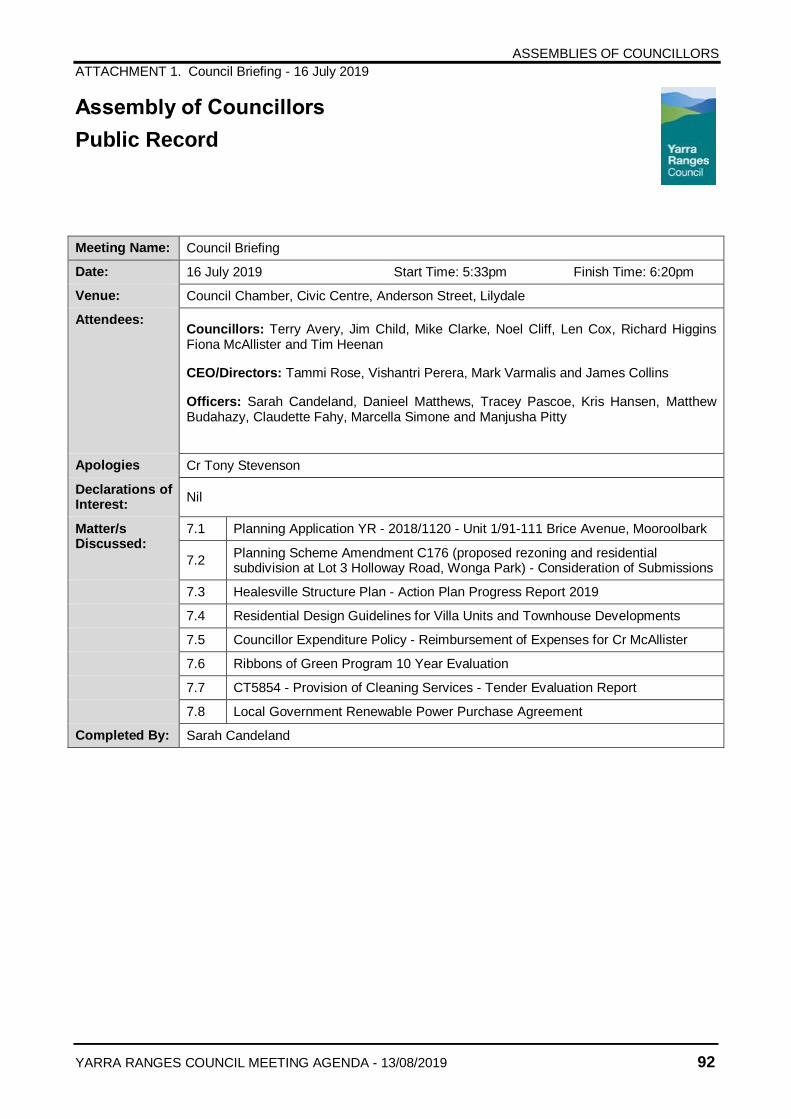
ASSEMBLIES OF COUNCILLORS
ATTACHMENT 1. Council Briefing - 16 July 2019
YARRA RANGES COUNCIL MEETING AGENDA - 13/08/2019 92
Assembly of Councillors
Public Record
Meeting Name: Council Briefing
Date: 16 July 2019 Start Time: 5:33pm Finish Time: 6:20pm
Venue: Council Chamber, Civic Centre, Anderson Street, Lilydale
Attendees: Councillors: Terry Avery, Jim Child, Mike Clarke, Noel Cliff, Len Cox, Richard Higgins Fiona McAllister and Tim Heenan
CEO/Directors: Tammi Rose, Vishantri Perera, Mark Varmalis and James Collins
Officers: Sarah Candeland, Danieel Matthews, Tracey Pascoe, Kris Hansen, Matthew Budahazy, Claudette Fahy, Marcella Simone and Manjusha Pitty
Apologies Cr Tony Stevenson
Declarations of Interest:
Nil
Matter/s Discussed:
7.1 Planning Application YR - 2018/1120 - Unit 1/91-111 Brice Avenue, Mooroolbark
7.2 Planning Scheme Amendment C176 (proposed rezoning and residential subdivision at Lot 3 Holloway Road, Wonga Park) - Consideration of Submissions
7.3 Healesville Structure Plan - Action Plan Progress Report 2019
7.4 Residential Design Guidelines for Villa Units and Townhouse Developments
7.5 Councillor Expenditure Policy - Reimbursement of Expenses for Cr McAllister
7.6 Ribbons of Green Program 10 Year Evaluation
7.7 CT5854 - Provision of Cleaning Services - Tender Evaluation Report
7.8 Local Government Renewable Power Purchase Agreement
Completed By: Sarah Candeland
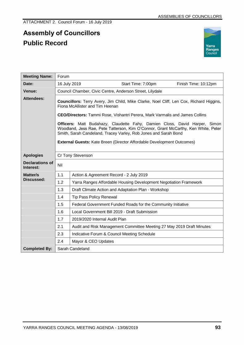
ASSEMBLIES OF COUNCILLORS
ATTACHMENT 2. Council Forum - 16 July 2019
YARRA RANGES COUNCIL MEETING AGENDA - 13/08/2019 93
Assembly of Councillors
Public Record
Meeting Name: Forum
Date: 16 July 2019 Start Time: 7:00pm Finish Time: 10:12pm
Venue: Council Chamber, Civic Centre, Anderson Street, Lilydale
Attendees: Councillors: Terry Avery, Jim Child, Mike Clarke, Noel Cliff, Len Cox, Richard Higgins, Fiona McAllister and Tim Heenan
CEO/Directors: Tammi Rose, Vishantri Perera, Mark Varmalis and James Collins
Officers: Matt Budahazy, Claudette Fahy, Damien Closs, David Harper, Simon Woodland, Jess Rae, Pete Tatterson, Kim O’Connor, Grant McCarthy, Ken White, Peter Smith, Sarah Candeland, Tracey Varley, Rob Jones and Sarah Bond
External Guests: Kate Breen (Director Affordable Development Outcomes)
Apologies Cr Tony Stevenson
Declarations of Interest:
Nil
Matter/s Discussed:
1.1 Action & Agreement Record - 2 July 2019
1.2 Yarra Ranges Affordable Housing Development Negotiation Framework
1.3 Draft Climate Action and Adaptation Plan - Workshop
1.4 Tip Pass Policy Renewal
1.5 Federal Government Funded Roads for the Community Initiative
1.6 Local Government Bill 2019 - Draft Submission
1.7 2019/2020 Internal Audit Plan
2.1 Audit and Risk Management Committee Meeting 27 May 2019 Draft Minutes
2.3 Indicative Forum & Council Meeting Schedule
2.4 Mayor & CEO Updates
Completed By: Sarah Candeland
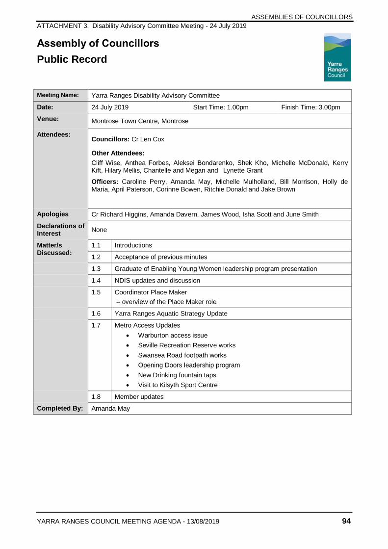
ASSEMBLIES OF COUNCILLORS
ATTACHMENT 3. Disability Advisory Committee Meeting - 24 July 2019
YARRA RANGES COUNCIL MEETING AGENDA - 13/08/2019 94
Assembly of Councillors
Public Record
Meeting Name: Yarra Ranges Disability Advisory Committee
Date: 24 July 2019 Start Time: 1.00pm Finish Time: 3.00pm
Venue: Montrose Town Centre, Montrose
Attendees: Councillors: Cr Len Cox
Other Attendees:
Cliff Wise, Anthea Forbes, Aleksei Bondarenko, Shek Kho, Michelle McDonald, Kerry Kift, Hilary Mellis, Chantelle and Megan and Lynette Grant
Officers: Caroline Perry, Amanda May, Michelle Mulholland, Bill Morrison, Holly de Maria, April Paterson, Corinne Bowen, Ritchie Donald and Jake Brown
Apologies Cr Richard Higgins, Amanda Davern, James Wood, Isha Scott and June Smith
Declarations of Interest
None
Matter/s Discussed:
1.1 Introductions
1.2 Acceptance of previous minutes
1.3 Graduate of Enabling Young Women leadership program presentation
1.4 NDIS updates and discussion
1.5 Coordinator Place Maker
– overview of the Place Maker role
1.6 Yarra Ranges Aquatic Strategy Update
1.7 Metro Access Updates
Warburton access issue
Seville Recreation Reserve works
Swansea Road footpath works
Opening Doors leadership program
New Drinking fountain taps
Visit to Kilsyth Sport Centre
1.8 Member updates
Completed By: Amanda May
YARRA RANGES COUNCIL MEETING AGENDA - 13/08/2019 95
13. REPORTS FROM DELEGATES
In accordance with Clause 30 of Meeting Procedures and Use of Common Seal Local Law 2015
14. CONFIDENTIAL ITEMS
In accordance with section 89(2) of the Local Government Act 1989
There were no Confidential Items for this meeting.
15. DATE OF NEXT MEETING
The next Ordinary meeting of Council is scheduled to be held on Tuesday 27 August 2019 commencing at 7.00pm, at Council Chamber, Civic Centre, Anderson Street, Lilydale.
In providing for the good governance of its community, Councillors are reminded of their obligation to abide by the provisions as set within the Local Government
Act 1989 and the Code of Conduct for Councillors.
When attending a Council Meeting, Councillors should adhere to the procedures set out in the Meeting Procedures and Use of Common Seal Local Law.
The following is a guide for all Councillors to ensure they act honestly, in good faith and in the best interests of Yarra Ranges as a whole.
1. Councillors will respect the personal views of other Councillors and the decisions of
Council. 2. Councillors may publicly express their own opinions on Council matters but not so as to
undermine the standing of Council in the community. 3. The Mayor is the official spokesperson for Council. 4. Councillors will incur expenditure in a responsible manner and in accordance with the
Councillor Expenditure and Policy. 5. Councillors will avoid conflicts of interest and will always openly disclose any direct and
indirect interests where they exist. 6. Councillors will act with integrity and respect when interacting with Council staff and
members of the public. 7. Councillors will demonstrate fairness in all dealings and conduct and be open with and
accountable to the community at all times. 8. Councillors will conduct themselves in a manner that does not cause detriment to
Council or the Yarra Ranges community.
This guidance forms part of the Code of Conduct for Councillors, adopted on 14 February 2017. The Code of Conduct is reviewed following each Council Election.