trimble gnss surveying systems - geometius · trimble gnss systems: solving your ... racing to...
TRANSCRIPT

trimble gnss surveying systems

TRIMBLE GNSS SYSTEMS: SOLVING YOUR CHALLENGES IN THE FIELD
INDUSTRY-LEADING GNSS SOLUTIONS DESIGNED WITH THE SURVEYOR IN MINDBacked by a legacy of GNSS technology and surveying expertise, Trimble provides surveyors with reliable GNSS survey solutions that meet their distinct requirements. For more than 30 years, Trimble has been setting the standard when it comes to positioning technology—and that tradition continues today and into the future.
POWERFUL TECHNOLOGY YOU CAN DEPEND ON…
…NO MATTER WHAT THE CHALLENGEWhether you are climbing over rough terrain to collect topographic data, racing to finish an as-built before nightfall, or staking out a road under the relentless summer sun, Trimble offers a complete portfolio of GNSS survey solutions to help you conquer your survey challenges.
Trimble offers survey professionals the GNSS options they require. Whether you need the cable-free convenience provided by Trimble integrated systems, the flexibility of Trimble modular systems, or the simplicity of handheld point measurement, Trimble has a solution for you.
Simply choose the system configuration and level of GNSS support that best fits your application and business needs.
ENABLING YOU TO BE THE BESTThrough every stage of your surveying project, a Trimble GNSS system ensures you’re working at optimal efficiency with the utmost confidence in your work:• Experience productivity that goes beyond having the best
GNSS technology on the market• Collect more data in less time via comprehensive GNSS
support and an abundance of powerful features, including Trimble HD-GNSS and Trimble® R-Track™ technologies
• Combine surveying technologies, including Trimble optical and GNSS solutions, to accomplish more in the field
• Reduce rework with quality control features, such as Trimble SurePoint™ technology
• Easy-to-use field solutions allow you to get the most out of your GNSS system
GNSS SYSTEMS FOR ALL YOUR APPLICATION NEEDSBuilt on a foundation of established and durable hardware, customizable software, and services, Trimble surveying systems are designed to support a range of surveying applications including:• Architecture• Cadastral & Boundary Surveying• Geodetic & Control Surveying• Land Seismic, Exploration, and Natural Resources• Land Surveying• Mining• Utilities & Transportation
By providing comprehensive GNSS signal support and more, Trimble enables you to decrease downtime in the field, improve job performance, and protect your investment in the future – no matter what the application.
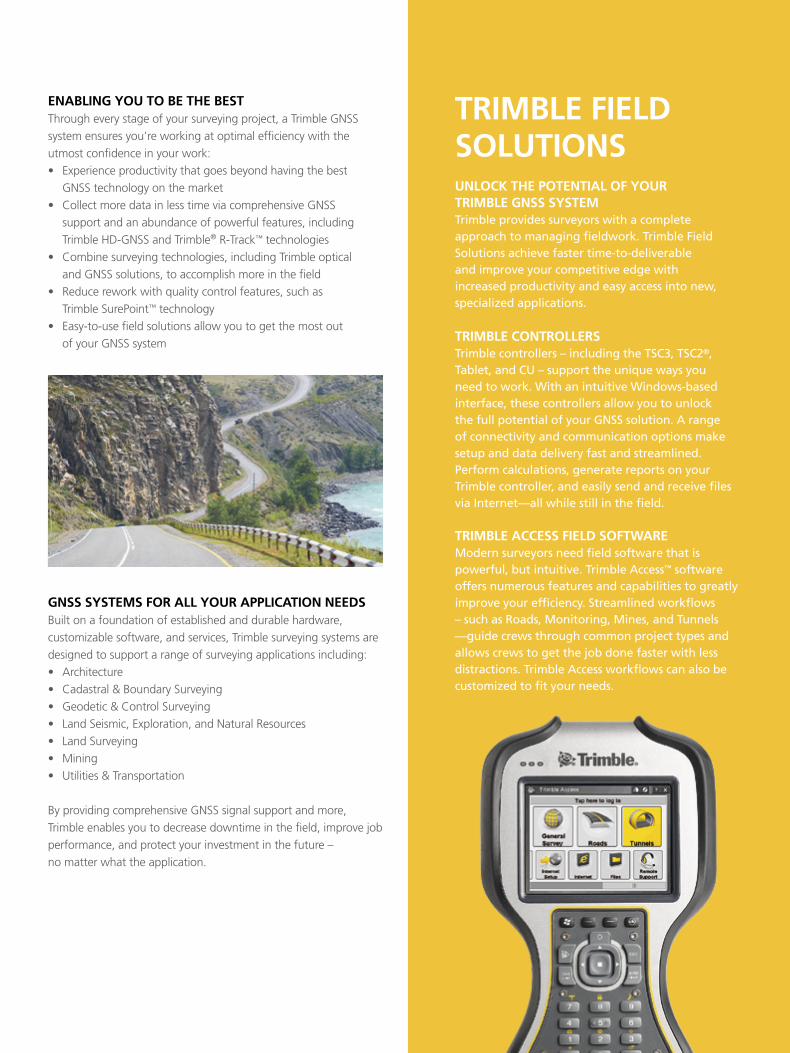
TRIMBLE FIELD SOLUTIONSUNLOCk THE POTENTIAL OF YOUR TRIMBLE GNSS SYSTEMTrimble provides surveyors with a complete approach to managing fieldwork. Trimble Field Solutions achieve faster time-to-deliverable and improve your competitive edge with increased productivity and easy access into new, specialized applications.
TRIMBLE CONTROLLERSTrimble controllers – including the TSC3, TSC2®, Tablet, and CU – support the unique ways you need to work. With an intuitive Windows-based interface, these controllers allow you to unlock the full potential of your GNSS solution. A range of connectivity and communication options make setup and data delivery fast and streamlined. Perform calculations, generate reports on your Trimble controller, and easily send and receive files via Internet—all while still in the field.
TRIMBLE ACCESS FIELD SOFTWAREModern surveyors need field software that is powerful, but intuitive. Trimble Access™ software offers numerous features and capabilities to greatly improve your efficiency. Streamlined workflows – such as Roads, Monitoring, Mines, and Tunnels —guide crews through common project types and allows crews to get the job done faster with less distractions. Trimble Access workflows can also be customized to fit your needs.

TRIMBLE HD-GNSS PROCESSING ENGINEA NEW GENERATION OF CORE POSITIONING TECHNOLOGY
Integrated into the Trimble R10, the Trimble HD-GNSS processing engine transcends traditional fixed/float techniques to provide a more accurate assessment of error estimates than traditional GNSS processing engines, especially in challenging environments. Markedly reduced convergence times as well as high position and precision reliability enable surveyors to collect measurements with confidence.
Whether you are working in real-time or in a post-processing application, Trimble HD-GNSS will let you work at optimal efficiency. For real-time applications, experience reduced GNSS survey startup times and improved reliability of reported RTK precisions. For post-processed applications, experience faster processing with a simplified workflow that typically does not require raw GNSS data filtering before processing.
INTEGRATED GNSS SYSTEMS: ALL THE CAPABILITY YOU REQUIRE IN ONE DEVICETRIMBLE INTEGRATED SySTEMS CoMBINE THE GNSS RECEIVER, ANTENNA, RADIo-MoDEM, AND BATTERy INTo A SINGLE INTEGRATED, CoMPACT UNIT. THIS PoPULAR CoNFIGURATIoN GIVES SURVEyoRS THE LATEST IN GNSS TECHNoLoGy IN A USER-FRIENDLy SySTEM THAT IS LIGHTWEIGHT, RUGGED, AND CABLE FREE.
TRIMBLE R10PRODUCTIVITY BEYOND GNSSDesigned to help surveying professionals work more effectively, the new Trimble R10 represents the next generation of GNSS Surveying. With powerful new technologies that go beyond comprehensive GNSS support, the premier Trimble R10 enables the surveyor to collect more reliable data – no matter what the job.• Cutting edge Trimble HD-GNSS processing engine enables
surveyors to measure points more quickly.• Record pole tilt information for all points collected using
Trimble SurePoint technology for enhanced quality assurance. • Trimble xFill™ technology provides RTK coverage during
connection outages for less downtime in the field.• Powerful 440 channel solution with Trimble 360 technology
delivers the most advanced satellite tracking. • Ergonomic design for easier and more comfortable handling • Pair with Trimble Access and the TSC3 controller or Trimble
Tablet for the most powerful solution on the market.
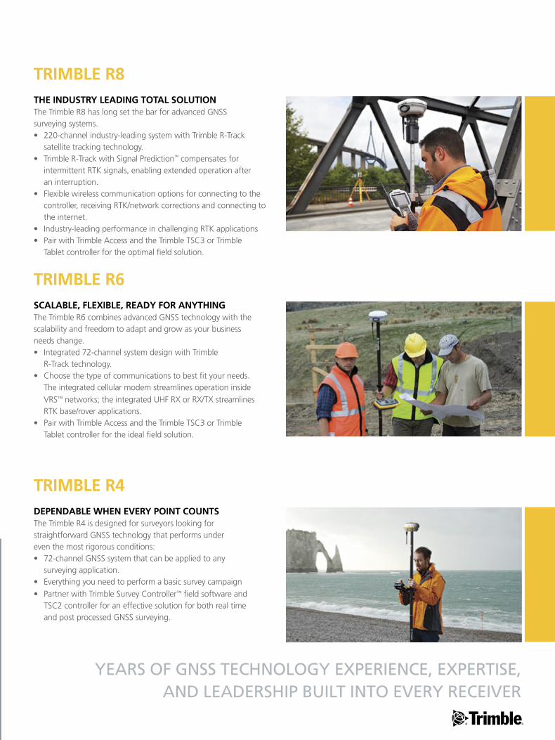
TRIMBLE R8THE INDUSTRY LEADING TOTAL SOLUTIONThe Trimble R8 has long set the bar for advanced GNSS surveying systems.• 220-channel industry-leading system with Trimble R-Track
satellite tracking technology.• Trimble R-Track with Signal Prediction™ compensates for
intermittent RTK signals, enabling extended operation after an interruption.
• Flexible wireless communication options for connecting to the controller, receiving RTK/network corrections and connecting to the internet.
• Industry-leading performance in challenging RTK applications • Pair with Trimble Access and the Trimble TSC3 or Trimble
Tablet controller for the optimal field solution.
YEARS OF GNSS TECHNOlOGY ExPERIENCE, ExPERTISE, AND lEADERSHIP BUIlT INTO EVERY RECEIVER
TRIMBLE R6SCALABLE, FLEXIBLE, READY FOR ANYTHINGThe Trimble R6 combines advanced GNSS technology with the scalability and freedom to adapt and grow as your business needs change.• Integrated 72-channel system design with Trimble
R-Track technology.• Choose the type of communications to best fit your needs.
The integrated cellular modem streamlines operation inside VRS™ networks; the integrated UHF RX or RX/TX streamlines RTK base/rover applications.
• Pair with Trimble Access and the Trimble TSC3 or Trimble Tablet controller for the ideal field solution.
TRIMBLE R4 DEPENDABLE WHEN EVERY POINT COUNTSThe Trimble R4 is designed for surveyors looking for straightforward GNSS technology that performs under even the most rigorous conditions:• 72-channel GNSS system that can be applied to any
surveying application.• Everything you need to perform a basic survey campaign • Partner with Trimble Survey Controller™ field software and
TSC2 controller for an effective solution for both real time and post processed GNSS surveying.
MODULAR GNSS SYSTEMS: SUPPORTING THE UNIQUE WAYS YOU WORkIN A MoDULAR TRIMBLE GNSS SySTEM, yoU CAN
CHooSE THE RADIo AND GNSS ANTENNA THAT MAKES
THE MoST SENSE FoR yoUR APPLICATIoN.
SYNERGY AT WORk: THE COMPLETE SOLUTION THE TRIMBLE SYSTEM OF HARDWARE AND SOFTWARE THAT’S kNOWN AND TRUSTED
TRIMBLE HAS DEVELoPED AN ENTIRE SySTEM CoMPoSED oF
THE MoST ADVANCED HARDWARE, SoFTWARE, AND SERVICES
AVAILABLE oN THE MARKET. WHETHER yoU ARE IN THE FIELD
oR BACK IN THE oFFICE, THE TRIMBLE SUITE oF SoLUTIoNS
– WHICH INCLUDES HANDHELD CoNTRoLLERS, oPTICAL
HARDWARE, GNSS HARDWARE, AND FIELD AND oFFICE
SoFTWARE—SIMPLIFIES THE SURVEy WoRKFLoW To HELP yoU
ACCoMPLISH yoUR oBjECTIVES qUICKLy AND EFFECTIVELy.
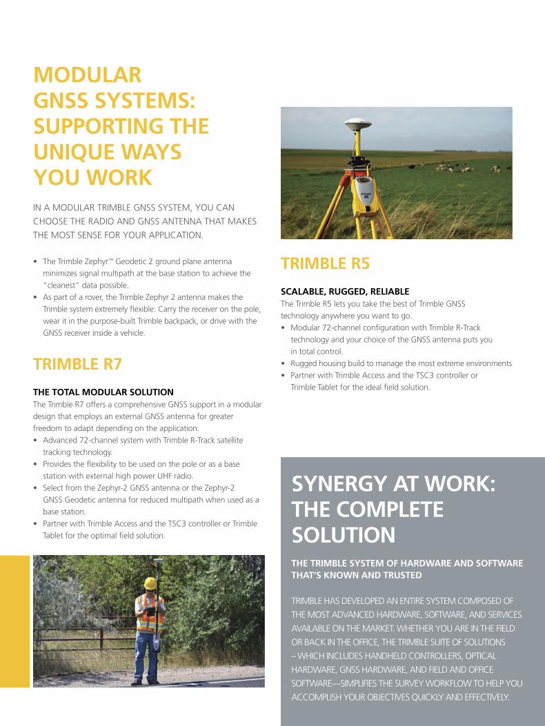
• The Trimble Zephyr™ Geodetic 2 ground plane antenna minimizes signal multipath at the base station to achieve the “cleanest” data possible.
• As part of a rover, the Trimble Zephyr 2 antenna makes the Trimble system extremely flexible: Carry the receiver on the pole, wear it in the purpose-built Trimble backpack, or drive with the GNSS receiver inside a vehicle.
TRIMBLE R7
THE TOTAL MODULAR SOLUTIONThe Trimble R7 offers a comprehensive GNSS support in a modular design that employs an external GNSS antenna for greater freedom to adapt depending on the application.• Advanced 72-channel system with Trimble R-Track satellite
tracking technology.• Provides the flexibility to be used on the pole or as a base
station with external high power UHF radio.• Select from the Zephyr-2 GNSS antenna or the Zephyr-2
GNSS Geodetic antenna for reduced multipath when used as a base station.
• Partner with Trimble Access and the TSC3 controller or Trimble Tablet for the optimal field solution.
TRIMBLE R5
SCALABLE, RUGGED, RELIABLEThe Trimble R5 lets you take the best of Trimble GNSS technology anywhere you want to go.• Modular 72-channel configuration with Trimble R-Track
technology and your choice of the GNSS antenna puts you in total control.
• Rugged housing build to manage the most extreme environments• Partner with Trimble Access and the TSC3 controller or
Trimble Tablet for the ideal field solution.
HANDHELD SYSTEMS: HIGH-ACCURACY SURVEY + HANDHELD POINT MEASUREMENTTRIMBLE GNSS HANDHELD SySTEMS oFFER HIGH-
ACCURACy RoVING oN THE PoLE PLUS THE CoNVENIENCE
oF HANDHELD DATA CoLLECTIoN WITH AN RTK PoSITIoN.
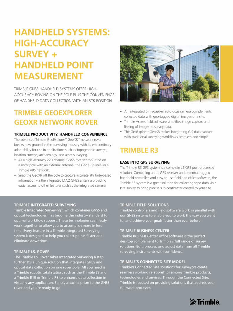
TRIMBLE GEOEXPLORER GEOXR NETWORk ROVER
TRIMBLE PRODUCTIVITY, HANDHELD CONVENIENCEThe advanced Trimble GeoExplorer® GeoXR™ network rover breaks new ground in the surveying industry with its extraordinary adaptability for use in applications such as topographic surveys, location surveys, archaeology, and asset surveying. • As a high-accuracy 220-channel GNSS receiver mounted on
a rover pole with an external antenna, the GeoXR is ideal in a Trimble VRS network.
• Snap the GeoXR off the pole to capture accurate attribute-based information via the integrated L1/L2 GNSS antenna providing easier access to other features such as the integrated camera.
• An integrated 5-megapixel autofocus camera complements collected data with geo-tagged digital images of a site.
• Trimble Access field software simplifies image capture and linking of images to survey data.
• The GeoExplorer GeoXR makes integrating GIS data capture with traditional surveying workflows seamless and simple.
TRIMBLE R3
EASE INTO GPS SURVEYINGThe Trimble R3 GPS system is a complete L1 GPS post-processed solution. Combining an L1 GPS receiver and antenna, rugged handheld controller, and easy-to-use field and office software, the Trimble R3 system is a great solution for collecting topo data via a PPK survey to bring precise sub-centimeter control to your site.
TRIMBLE INTEGRATED SURVEYINGTrimble Integrated Surveying™, which combines GNSS and optical technologies, has become the industry standard for optimal workflow support. These technologies seamlessly work together to allow you to accomplish more in less time. Every feature in a Trimble Integrated Surveying system is designed to help you collect points faster and eliminate downtime.
TRIMBLE I.S. ROVERThe Trimble I.S. Rover takes Integrated Surveying a step further. It’s a unique solution that integrates GNSS and optical data collection on one rover pole. All you need is a Trimble robotic total station, such as the Trimble S8 and a Trimble R10 or Trimble R8 to enhance data collection in virtually any application. Simply attach a prism to the GNSS rover and you’re ready to go.
TRIMBLE FIELD SOLUTIONSTrimble controllers and field software work in parallel with our GNSS systems to enable you to work the way you want to, and achieve your goals faster than ever before.
TRIMBLE BUSINESS CENTERTrimble Business Center office software is the perfect desktop complement to Trimble’s full range of survey solutions. Edit, process, and adjust data from all Trimble surveying instruments with confidence.
TRIMBLE’S CONNECTED SITE MODELTrimble’s Connected Site solutions for surveyors create seamless working relationships among Trimble products, technologies and services. Through the Connected Site, Trimble is focused on providing solutions that address your full work processes.
NORTH AMERICATrimble Navigation Limited10355 Westmoor DriveWesminster CO 80021USA
EUROPETrimble Germany GmbHAm Prime Parc 1165479 RaunheimGERMANY+49-6142-2100-0 Phone+49-6142-2100-550 Fax
ASIA-PACIFICTrimble Navigation Singapore Pty Limited80 Marine Parade Road#22-06, Parkway ParadeSingapore 449269 SINGAPORE+65-6348-2212 Phone+65-6348-2232 Fax
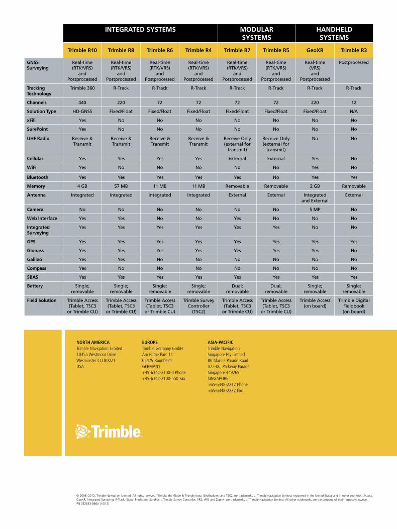
INTEGRATED SYSTEMS MODULAR SYSTEMS
HANDHELD SYSTEMS
Trimble R10 Trimble R8 Trimble R6 Trimble R4 Trimble R7 Trimble R5 GeoXR Trimble R3
GNSS Surveying
Real-time (RTK/VRS)
and Postprocessed
Real-time (RTK/VRS)
and Postprocessed
Real-time (RTK/VRS)
and Postprocessed
Real-time (RTK/VRS)
and Postprocessed
Real-time (RTK/VRS)
and Postprocessed
Real-time (RTK/VRS)
and Postprocessed
Real-time (VRS) and
Postprocessed
Postprocessed
Tracking Technology
Trimble 360 R-Track R-Track R-Track R-Track R-Track R-Track R-Track
Channels 440 220 72 72 72 72 220 12
Solution Type HD-GNSS Fixed/Float Fixed/Float Fixed/Float Fixed/Float Fixed/Float Fixed/Float N/A
xFill Yes No No No No No No No
SurePoint Yes No No No No No No No
UHF Radio Receive & Transmit
Receive & Transmit
Receive & Transmit
Receive & Transmit
Receive Only (external for
transmit)
Receive Only (external for
transmit)
No No
Cellular Yes Yes Yes Yes External External Yes No
WiFi Yes No No No No No Yes No
Bluetooth Yes Yes Yes Yes Yes No Yes Yes
Memory 4 GB 57 MB 11 MB 11 MB Removable Removable 2 GB Removable
Antenna Integrated Integrated Integrated Integrated External External Integrated and External
External
Camera No No No No No No 5 MP No
Web Interface Yes Yes No No Yes No No No
Integrated Surveying
Yes Yes Yes Yes Yes Yes No No
GPS Yes Yes Yes Yes Yes Yes Yes Yes
Glonass Yes Yes Yes Yes Yes Yes Yes No
Galileo Yes Yes No No No No No No
Compass Yes No No No No No No No
SBAS Yes Yes Yes Yes Yes Yes Yes Yes
Battery Single; removable
Single; removable
Single; removable
Single; removable
Dual; removable
Dual; removable
Single; removable
Single; removable
Field Solution Trimble Access (Tablet, TSC3
or Trimble CU)
Trimble Access (Tablet, TSC3
or Trimble CU)
Trimble Access (Tablet, TSC3
or Trimble CU)
Trimble Survey Controller
(TSC2)
Trimble Access (Tablet, TSC3
or Trimble CU)
Trimble Access (Tablet, TSC3
or Trimble CU)
Trimble Access (on board)
Trimble Digital Fieldbook (on board)
© 2008–2012, Trimble Navigation Limited. All rights reserved. Trimble, the Globe & Triangle logo, GeoExplorer, and TSC2 are trademarks of Trimble Navigation Limited, registered in the United States and in other countries. Access, GeoXR, Integrated Surveying, R-Track, Signal Prediction, SurePoint, Trimble Survey Controller, VRS, xFill, and Zephyr are trademarks of Trimble Navigation Limited. All other trademarks are the property of their respective owners. PN 022543-366A (10/12)