tree plantation strategy - world bank · pdf filetree plantation strategy ... indian states of...
TRANSCRIPT
E432Volurmie 17
Tree Plantation Strategy
Grand Trunk Road Improvement Project
National Highways Authority of IndiaI Eastern Avenue. Maharanibagh, Nev Delhi - 110 065
F ILE CO0,P Y
Pub
lic D
iscl
osur
e A
utho
rized
Pub
lic D
iscl
osur
e A
utho
rized
Pub
lic D
iscl
osur
e A
utho
rized
Pub
lic D
iscl
osur
e A
utho
rized
Pub
lic D
iscl
osur
e A
utho
rized
Pub
lic D
iscl
osur
e A
utho
rized
Pub
lic D
iscl
osur
e A
utho
rized
Pub
lic D
iscl
osur
e A
utho
rized
-ABLE OF CONTENTS
PLANTATION STRATEGY FOR GTRLIP .................................... . . ................................1
BACKGROUND .......... 1 .. .... . .. .. 1
IMPACT ON FLORA ............................................ ........................................................... 2
OBJECTIVES OF TREE PLANTATION STRATEGY ................................. ........... ... 3
SELECTION OF TREE SPECIES FOR LANDSCAPING .. 3
Screening ......... , .. . . 3
Aesthetics.
aShade . ... ..................................... ............ ............................................... ............ ...............................4
Fruit, Fodder and Fuel .... 4
Natural Reserves and asset .4
Other benefits ............................................... 4
PL.ANTATION PATTERN .... 4..................................................................................4
Shade Plants .................... 6 . .,,,,.,.......6
Ornamental and Other Species .7
CONCEPT OF PLANTATION FOR DIFFERENT AREAS .9
Rural areas ..................... 9.......................9
Urban Areas ... 9
EdgesAlong Clear Zone...... 9
Water LoggedAreas...... 9
Protected Forest / Reserved Foret .l Areas ..... 10
Ta] Trapezium Zone ..... 10
PROPOSED PLANTATION SCHEME ..... I I
PLANTATION SPECIFICATIONS .................................. ......................................................... 15
TREE PLANThjVG ALONG THE HIGH IA YS . .
Protectior Measures .............. , , 16
REQUIREMENT OF PLANTS ...................................... 17
PLANTING ON THE MEDIAN .. 17
PLANTING AM TERIAL: .. 19
Entire Transplant .............. . .. , . ...... , ...,,,,.,.,,,,.,,,..... 19
Polythene bag plants ,.., .. , 19
C u ttinng s ............................................................................................................................................ , ., ,, , , l9
LANDSCAPING AT SPECIFIC IDEJNTIFIED SITES . .21
Landscaping At Road Junctionilntersection And Traffic Islands .21
Landscaping at Sensitive noise receptors ................................... .,, , ,.,.,.,.24
INSTITUTIONAL MECHANISM AND MONITORING .. 25
PLANTATION STRATEGY FOR GTRIP
BACKGROUNDThe Grand Trunk Road between Wagha border (Amritsar) and Kolkata traverses across the six
Indian states of Punjab, Haryana, Dt-ni, Uttar Pradesh (UP), Bihar and West Bengal and it mainly
falls in the fertile Indo-Gangetic plains. This highway has been the conduit of development for the
past several centuries, and seven of the 28 metropolitan cities of the country are located along the
highway. It has over 10% of the urbanisation within 10km influence area on either side. As a result
of the intense developmental activities along the highway, this area (10km on either side) supports a
population of over 40 million. The highway between Agra and Dhanbad passes through two of the
most populous and the least developed states in India.
The Delhi to Agra section at the western end and Dhanbad to Calcutta section at the Eastern End of
the Corridor are either already 4-laned or are in the process of being 4-laned. The remaining about
1 000 km long corridor falling between Agra and Dhanbad is still two laned and is being considered of
four laning under the proposed Woiid Bank NH Project. The Grand Trunk Road Improvement
Project (GTRIP) aims at strengthening and four laning of 422.78 km of selected stretches between
Agra to Dhanbad as per details given under Table 1.
Table I GTRIP Contract Packages
PACKAGES CONTRACT PACKAGES FOR ICB LENGTH KMI [Agra - Bhognipur] I-A [Agra-Shikohabad] 50.84
[km 199.66-250.5]I-B [Shikohabad-Etawah Bypass (start)] 59.02
[km. 250.5-307.5]I-C [Etawah bypass(end)- Bhognipur 72.825
-m. 321.100 - 393.01II [Khaga - Varanasi] Il-B (Khaga-Kokhraj] 43.00
[km.1 15-158]IV [Varanasi-Aurangabad] IV-A[Mohania-Sasram Bypass] 78.00
[km 65-1101IV-C [Sone River -Aurangabad] 40.00
[km 140-180]V [Aurangabad-Dhanbad] V-B [Aurangabad-Barachetti] 60.00
[km 180-2401The stretch of NH-2, in GTRIP, (Packages- I-A, I-B, I-C, Il-B, IV-A, IV-C and V-B) is proposed to be
strengthened and reinforced using various techniques of soft landscapes, principally through
plantation of various types. A Road landscape Plan has been developed to enhance the visual
1
quality of the road. The landscape treatments are not only to mitigate the visual impacts of the
construction, but also to glorify the historic context of the road.
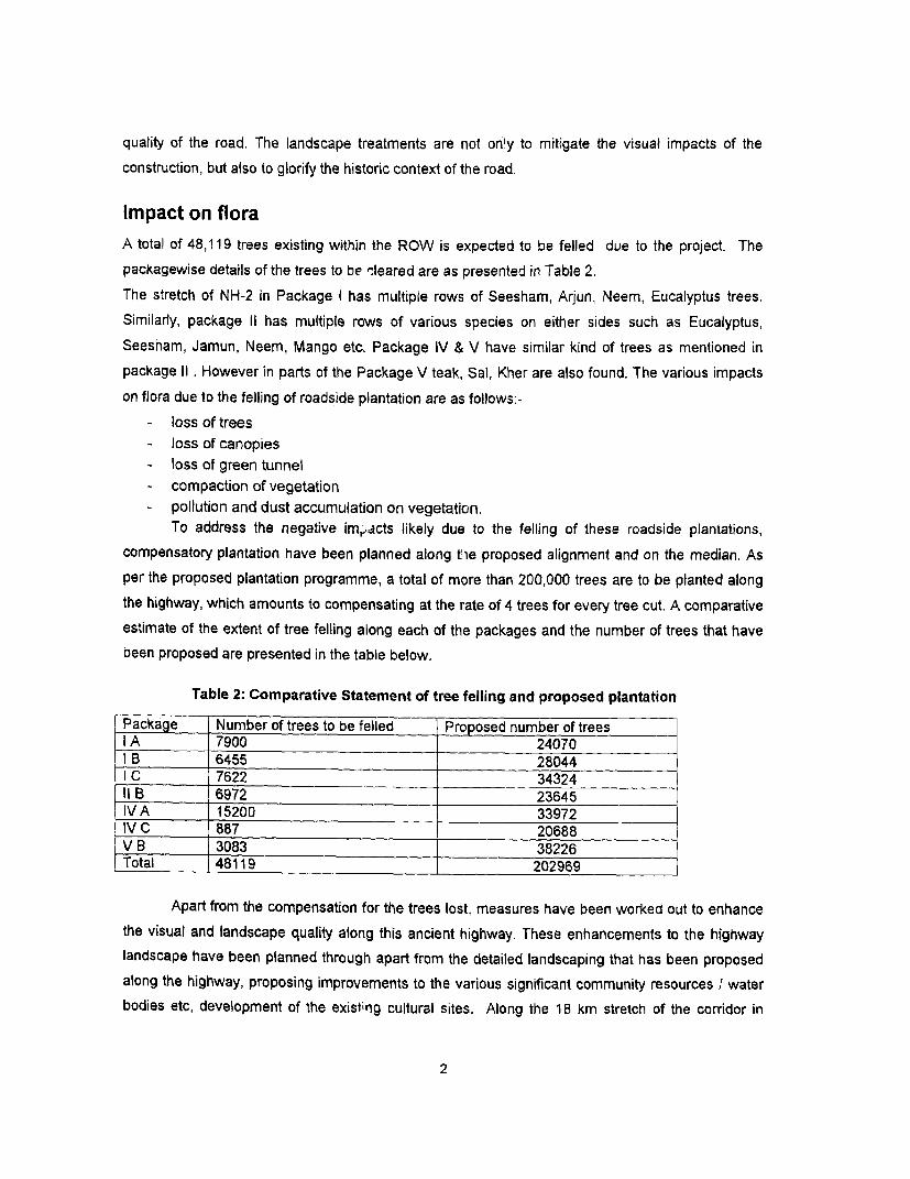
Impact on floraA total of 48,119 trees existing within the ROW is expected to be felled due to the project. The
packagewise details of the trees to be 'leared are as presented in Table 2.
The stretch of NH-2 in Package I has multiple rows of Seesham, Arjun, Neem, Eucalyptus trees.
Similarly, package 11 has multiple rows of various species on either sides such as Eucalyptus,
Seesham, Jamun, Neem, Mango etc. Package IV & V have similar kind of trees as mentioned in
package 11 . However in parts of the Package V teak, Sal, Kher are also found. The various impacts
on flora due to the felling of roadside plantation are as follows:-
- loss of trees- loss of canopies- loss of green tunnel- compaction of vegetation- pollution and dust accumulation on vegetation.
To address the negative imracts likely due to the felling of these roadside plantations,
compensatory plantation have been planned along tie proposed alignment and on the median. As
per the proposed plantation programme, a total of more than 200,000 trees are to be planted along
the highway, which amounts to compensating at the rate of 4 trees for every tree cut. A comparative
estimate of the extent of tree felling along each of the packages and the number of trees that have
been proposed are presented in the table below.
Table 2: Comparative Statement of tree felling and proposed plantation
Package Number of trees to be felled Proposed number of treesIA 7900 24070lB 6455 28044IC 7622 3432411 B 6972 23645IVA 15200 33972IV C 887 20688V B 3083 38226Total 48119 202969
Apart from the compensation for the trees lost, measures have been worked out to enhance
the visual and landscape quality along this ancient highway. These enhancements to the highway
landscape have been planned through apart from the detailed landscaping that has been proposed
along the highway, proposing improvements to the various significant community resources I water
bodies etc, development of the existing cultural sites. Along the 18 km stretch of the corridor in
2
Package V B that passes through the Gautama Buddha Wildlife Sanctuary, an additional 12,000
trees will be planted along the animal routes within the sanctuary area.
The tree plantation strategy along the GT road has been conceptualized keeping in mind a
set of objectives, including road safety, to improve the overall visual and environmental quality of the
project corridor.
Objectives of Tree Plantation StrategyThe broader objectives of tree plantation / landscaping are:
- Climatic amelioration,- Check in air & noise pollution,- Check in soil erosion and reduce water logging,- Moderating the effect of wind and incoming radiation, and- Aesthetics, shade and ornamentation.
In addition to the specific aim of tree plantation / landscaping along the GT Road is -
- To enhance the visual experience of traveling along the GT Road;- To define the RoW especially highlights sharp horizontal curves during night;- To screen unsightly view from the road as well as the roadside communities from air &
noise pollution;- To compensate for the trees proposed to be cut;- Selective plantation at bus stops/rest areas/truck lay byes etc, and- To enhance sites of natural and cultural importance.- To prevent the glare from the incoming vehicles
Selection of Tree Species for LandscapingPlantation is one of the most important constituents of soft landscaping. Trees, shrubs and climbers
have been used to enhance the soft natural ambience against harsh elements in most of the
enhancement schemes. The planting species are decided based on the physical growth
characteristics of trees, like form and shape, foliage pattern, growth rate, branching pattem, soil
characteristics and conditions of the strip like water logged areas etc. While selecting the species of
trees for landscaping a great care has been taken to choose from the already existing indigenous
species along the project corridor. The selection of plant types and planting arrangement has been
based on the following considerations:
Screening
Plantation of pollution hardy shrub dwarf species in the median to prevent glare from the vehicles
moving in opposite direction during night.
A mix of medium and large trees along roadside to screen the evening glare for the traffic moving
towards west-northwest.
3
Screen plantation as a visual barrier in schools, hospitals, residential colonies, etc.
Aesthetics
Provision of flowering trees in the urban sections and major crossings
Provision of flowering shrubs in the median
Softening of vertical surfaces of the retaining walls of grade separators and raised sections of the
carriageway by climbers.
Shade
Large and spreading shade trees, with thick foliage are proposed in the innermost edge. This is
meant for the slow moving traffic that shall ply along the paved shoulders of the proposed corridor.
Medium evergreen shade trees on footpaths in the urban sections have been provided. Evergreen
trees do not have substantial leaf fall, which avoids the nuisance of clogging of lined drains.
Fruit, Fodder and Fuel
Provision of trees that have economic importance where space is available between the shade trees
and the edge of the RoW for the local village people.
Natural Reserves and asset
The economic trees may be harvested on maturity and generate revenue for the body responsible
for tree plantation and maintenance. These stretches shall also house valuable soil micro flora and
micro fauna.
Other benefits
Trees along the highway and ground cover along the embankment slopes and near major water
bodies play a major role in the control of erosion. Similarly, plantation and green covering in the form
of turfing stabilizes steep slopes and high embankrnents. Along water logged areas, plantation of
tree species such as Eucalyptus shall aid in the maintenance of water balance.
Plantation PatternThe road landscape has been developed envisaging a holistic approach to the entire stretch. A
concept has been evolved so as to maintain visual characteristics and uniformity in terms of
landscape along the stretch. In the absence of uniform land availability for the plantations, different
schemes have been worked out in tune with the local variations in the design. To achieve this, the
entire stretch of the project corridor has been divided into homogenous landscape sections based on
similarity in terms of soil conditions, climate (temperature and rainfall) and topography. A study on
the local flora and vegetative cover native to these sections has been carried out as part of the field
surveys to enable a choice of the suitable species for that particular section.
In order to identify sections with similar natural factors the entire project corridor was divided into 13
homogeneous stretches with similar climatic (rainfall and temperature), soil and topographic
characteristics, as shown in the following table.
4
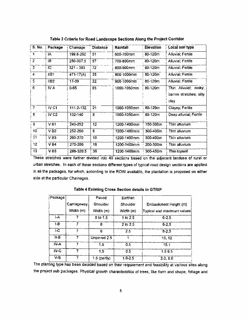
Table 3 Criteria for Road Landscape Sections Along the Project Corridor
S. No. Package Chainage Distance Rainfall Elevation Local soil type1 IA 199.6-250 51 600-700mm 80-120m Alluvial; Fertile2 IB 250-307.5 57 700-800mm 80-120m Alluvial; Fertile3 IC 321 - 393 72 800-9OOmm 80-120m Alluvial; Fertile4 IIB1 471-17(A) 35 900-1000mm 80-120m Alluvial; Fertile4 5 B112 17-39 22 900-1000mm 80-120m Alluvial; Fertile6 IVA 0-65 65 1000-1050mm 80-120m Thin Alluvial; rocky;
barren stretches; silty
clay7 IV CV 111.2-132 21 1000-1050mm 1 80-120m Clayey; Fertile8 IV C2 132-140 8 1000-1050mm 80-120m Deep alluvial; Fertile
9 V Bi 240-252 12 1200-1400mm 150-300m Thin alluvium10 V B2 252-260 8 1200-1400mm 300-400m Thin alluvium11 V 83 260-270 10 1200-1400mm 300-400m Thin alluvium12 V B4 270-286 16 1200-1400mm 200-300m Thin alluvium13 V B5 286-320.5 36 1200-1400mm 300-450m Thin topsoilThese stretches were further divided into 40 sections based on the adjacent landuse of rural orurban stretches. In each of these sections different types of typical road design sections are appliedin all the packages, for which, according to the ROW available, the plantation is proposed on eitherside at the particular Chainages.
Table 4 Existing Cross Section details in GTRIP
Package Paved EarthenCarriageway Shoulder Shoulder Embankment Height (m)Width (in) Width (m) Width (m) Typical and maximum values
I-A 7 Oto 1.5 1 to 2.5 6-2.5I-B 7 0 2 to 2.5 6-2.5I-C 7 0 2.5 6-2.5Il-B 7 Unpaved 2.5 1 10,12IV-A 7 1.5 0.5 15.1IV-C 7 1.5 0.5 1.5 9.5V-B 7 1.5 (partly) 1.0-2.5 2.0, 8.0
The planting type has been decided based on their requirement and feasibility at various sites alongthe project sub packages. Physical growth characteristics of trees, like form and shape, foliage and
5
rooting characteristics, growth rate, canopy type and branching pattern were the major criteria in the
selection of plantation type and density.
The space available in the RoW is one major guiding factor for different themes of landscaping
applied in the entire corridor. The analysis of RoW along GT Road reveals a highly varied picture.
Over 50% of the total length has an average RoW width of 40-45m (nearly 203km) followed by 22%
with 30-35m RoW. A substantial portion of the length, i.e., about 17.5% has a liberal RoW of about
60m or more. Accordingly, a plantation pattern has been worked out as follows:
The first row along the Highways will be of shade plants.
Subsequent rows depending on the availability of width will comprise of ornamental and otherspecies.
Planting of shrubs in the medianShade Plants
One of the main objectives of Roadside Avenue is to provide shade. The first row of trees
primarily consists of shade trees, at a spacing of 12rn C/C. These tree species are the locally
significant and are mostly evergreen in nature, which ensures no substantial leaf fall in winters
preventing the problem of blockage of roadside drains. Trees with the following characteristics
will be planted as shade trees:-
1. Trees with high crown forms secure better visibility and are therefore ideal.
2. Trees that retain their foliage longest are preferred to deciduous trees.
3. Trees with long gestation period and having rapid growth and a capacity to resist
fungal and insects attack form ideal avenues.
4. Long slender trees unable to support their own weight and trees with low crown
density decreasing visibility have been avoided.
5. Fruit trees are generally avoided with exception to Mango, Imli, Jamun as these form
excellent avenues.
6. Brittle trees, like Millingtonia hortensis are not recommended.
7. Those trees have been preferred which have thick shade and are also valuable from
economic point of view.
A major length of the GTRIP corridor falls within the Gangetic Plains with rich alluvial, loamy
soils, which can support the tree plantations. However, there are certain stretches where usar
(alkaline) lands exist, and some other stretches with sandy soils. These usar [alkalinel lands and
heavy clays do not support any significant vegetation beyond grass, or dhak, babul, none of
which afford satisfactory shade. The only species that can survive are Neem and Kanji, and
have been recommended. Similarly, along stretches with sandy soils, Shesham is the species
6
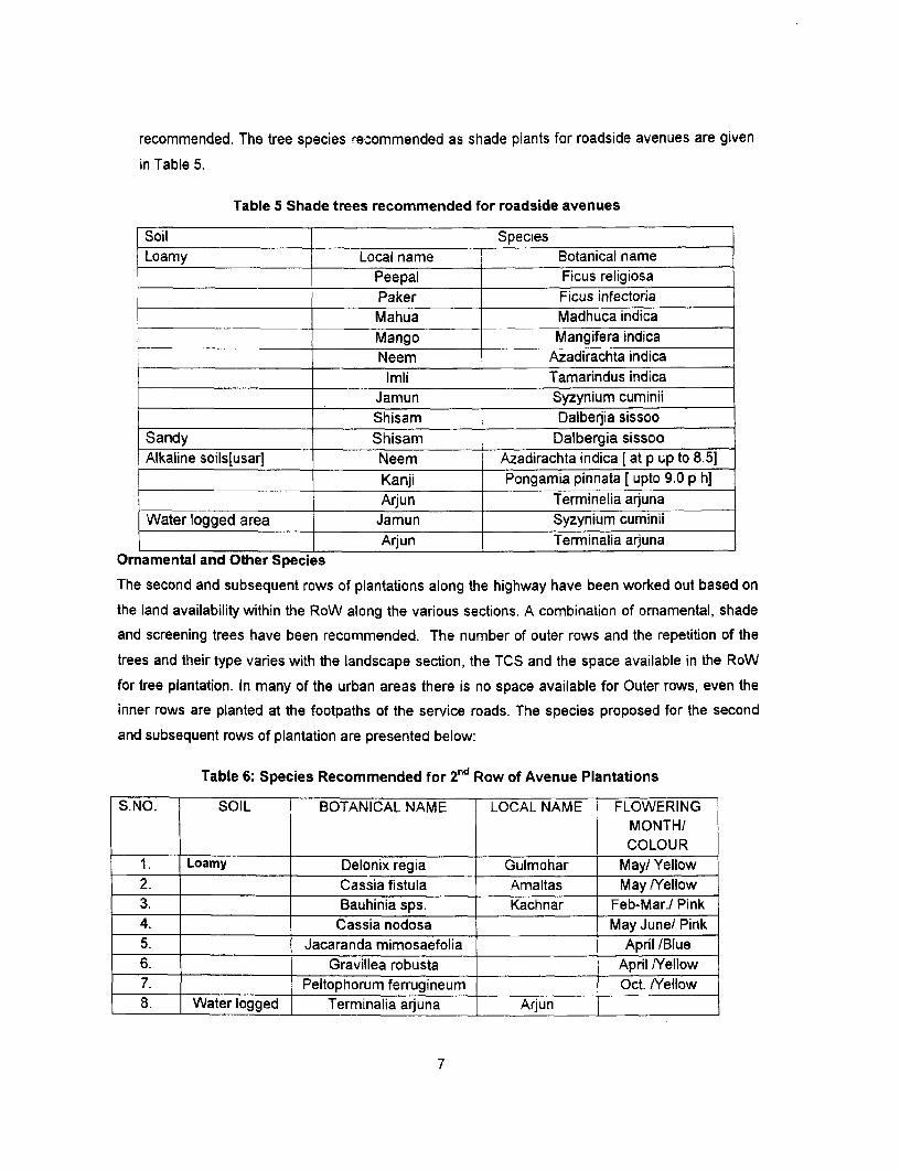
recommended. The tree species recommended as shade plants for roadside avenues are given
in Table 5.
Table 5 Shade trees recommended for roadside avenues
Soil SpeciesLoamy Local name Botanical name
Peepal Ficus religiosaPaker Ficus infectoriaMahua Madhuca indicaMango Mangifera indicaNeem Azadirachta indicaImli Tamarindus indica
Jamun Syzynium cuminiiShisam Dalberjia sissoo
Sandy Shisam Dalbergia sissooAlkaline soils[usarl Neem Azadirachta indica [at p up to 8.5]
Kanji Pongamia pinnata [ upto 9.0 p h]Arjun Terminelia arjuna
Water logged area Jamun Syzynium cuminiiArjun Terminalia arjuna
Ormamental and Other Species
The second and subsequent rows of plantations along the highway have been worked out based on
the land availability within the RoW along the various sections. A combination of ornamental, shade
and screening trees have been recommended. The number of outer rows and the repetition of the
trees and their type varies with the landscape section, the TCS and the space available in the RoW
for tree plantation. In many of the urban areas there is no space available for Outer rows, even the
inner rows are planted at the footpaths of the service roads. The species proposed for the second
and subsequent rows of plantation are presented below:
Table 6: Species Recommended for 2nd Row of Avenue Plantations
S.NO. SOIL BOTANICAL NAME LOCAL NAME FLOWERINGMONTH/COLOUR
1. Loamy Delonix regia Gulmohar May] Yellow2. Cassia fistula Amaltas May /Yellow3. Bauhinia sps. Kachnar Feb-Mar./ Pink4. Cassia nodosa May June/ Pink5. Jacaranda mimosaefolia April [Blue6. Gravillea robusta April NYellow7. Peltophorum ferrugineum Oct. /Yellow8. Water logged Terminalia arjuna Arjun
7
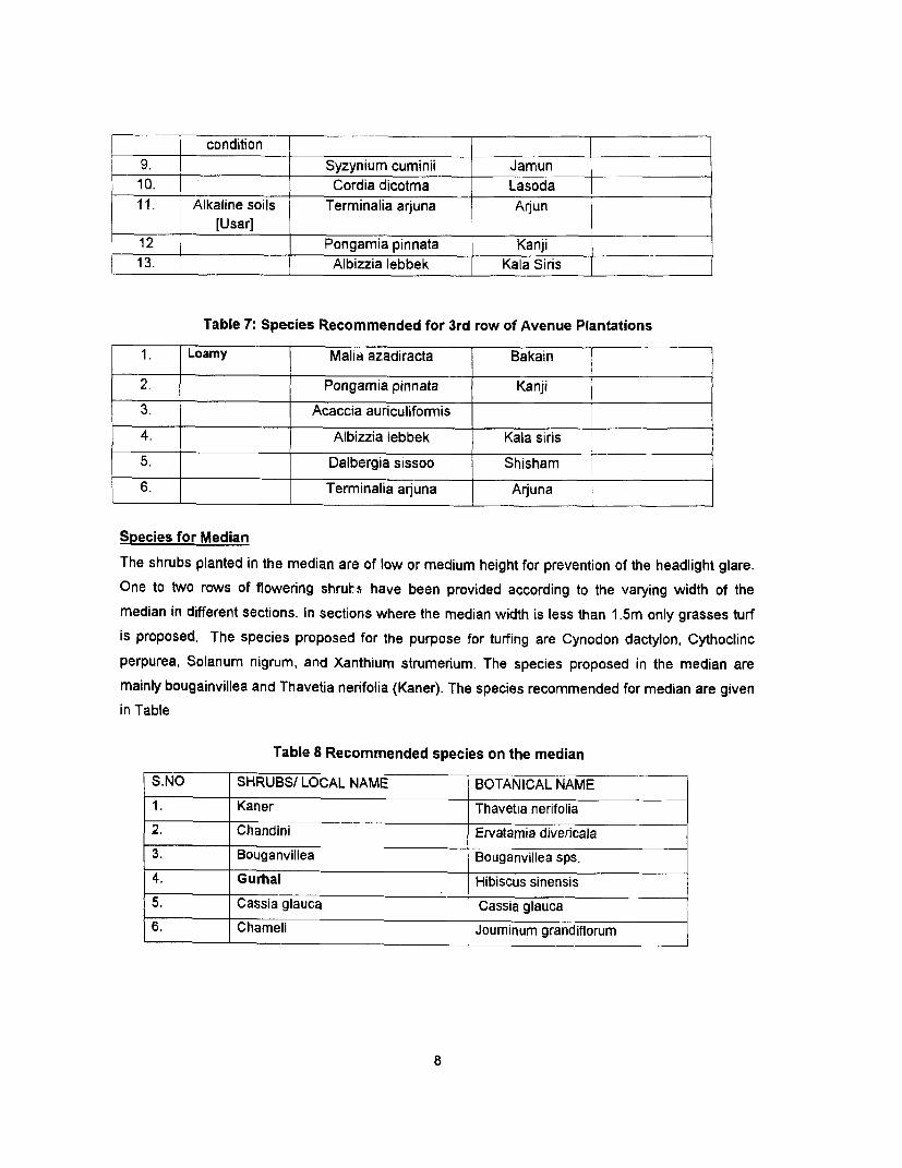
________ condition9. Syzynium cuminii Jamun10. Cordia dicotma Lasoda11. Alkaline soils Terminalia arjuna Arjun
[Usar]12 Pongamia pinnata Kanji13. Albizzia lebbek Kala Siris
Table 7: Species Recommended for 3rd row of Avenue Plantations
1. Loamy Malia azadiracta Bakain
2. Pongamia pinnata Kanji
3. Acaccia aurculiformis
4. Albizzia lebbek Kala siris
5. Dalbergia sissoo Shisham
6. Terminalia anjuna Arjuna
Species for Median
The shrubs planted in the median are of low or medium height for prevention of the headlight glare.
One to two rows of flowering shrutsi have been provided according to the varying width of the
median in different sections. In sections where the median width is less than 1.5m only grasses turf
is proposed. The species proposed for the purpose for turfing are Cynodon dactylon, Cythoclinc
perpurea, Solanum nigrum, and Xanthium strumerium. The species proposed in the median are
mainly bougainvillea and Thavetia nerifolia (Kaner). The species recommended for median are given
in Table
Table 8 Recommended species on the median
S.NO SHRUBS/ LOCAL NAME BOTANICAL NAME
1 . Kaner Thavetia nerifolia
2. Chandini Ervatamia divericala
3. Bouganvillea Bouganvillea sps.
4. Gurhal Hibiscus sinensis
5. Cassia glauca Cassia glauca
6. Chameli Jouminum grandiflorum
8
CONCEPT OF PLANTATION FOR DIFFERENT AREASRural areas
Common plants generally recommended for national and state highways passing through rural
areas, are Amaltas (Cassia fistula) alternating with shade trees like, Azadirachta indica, Tarmarindus
indica. Tall trees like Eucalyptus are not suitable as they interfere with electric and telephone lines
and moreover are safety hazards on the road. Medium trees like, Acacia auriculiformis, Gravillea
robusta, are ideal for screening. In a tropical country like India, where the temperature during
summer months may rise up to a maximum of 46°C or more, the 'shade' is of greatest value to the
travelers. Thomy trees like Acacia Arabica and Ber (Zizyphusjujuba) are avoided, as these create a
nuisance for the pneumatic tyre of motor vehicles.
Urban Areas
Near market places and congested areas, the trees known for behaving as 'pollution sink' are
proposed. Though, trees in general absorb the pollutants, filter the air from pollutants, and act as
noise barrier, but some trees like Neem (Azadirachta Indica), Mango (Mangifera Indica), Paker
(Ficus Infectoria), Shisham (Dalbergia Sisso), Imli (Tamarindus Indica) can do it in a better way.
Near sensitive areas like schools and hospitals, tall trees with thick canopies can create a wind
screen through which the air can be filtered and the noise levels be considerably reduced. Some
such trees are Acacia auriculiformis and Gravillea robusta. Tall shrubs like Casia biflora, hamelia
patens etc are provided at the sensitive noise receptors for maximum possible screening.
Edges Along Clear Zone
The clear zone along the Grand Trunk Road is of varied nature depending upon the different
embankment heights. Some areas have steep gradients that need intensive stone pitching
treatment. In order to increase the structural stability of this type of treatments, plant materials such
as shrubs and ground covers, can be introduced in the interstices. They can be used with emphasis
on their rooting characteristics, so that they help in binding the stone pitching treatments. In areas of
high water table or water logging, special emphasis has been given on the selection of plant
materials that can survive in moist ccnditions.
Water Logged Areas
Waterlogged areas along the road are generally a result of Inadequate drainage conditions, the road
acting as a bund and contributing to water logging, high water table of the region or the Low lying
nature of the terrain itself.
Water logged areas are generally associated with larger water bodies, serving as waterfowl habitat
and often, scenic spots with religious and recreational setting. One of the common situations met for
roadside plantation is the water logging since roadsides have been dug for excavating the earth for
9
putting on road edge. This type of situation is common throughout the plains in the country. Planting
of such sites after proper drainage is now a common practice. Eucalyptus sp, Terminalia arjuna,
Scyzinium cuminii are recommended species for waterlogged areas.
Protected Forest I Reserved Forest Areas
The design has been worked out to minimise the impacts on the forest stretches along the proposed
alignment. The acquisition of 0.5 ha of forest land in Package I A and 1.28 ha of forest land in
Package IV C has been unavoidable and the clearance of these forests are being taken up in
accordance to the Gol requirements.
For stretches of the corridor through the reserved / protected areas, the contractor shall ensure that
the construction activities shall be limited to the proposed RoW, so as to avoid any impacts on the
vegetation vithin the forest areas.
Along the sections passing through protected I reserved forests, dense plantation has been
proposed within the RoW. Apart from these, if the forest department wishes to establish a buffer',
NHAI as part of the project shall contribute a portion of the estimated budget for the establishing a
vegetative buffer between the forest and the highway. All species proposed in the reserved forest
areas shall be native of the forest area. In package V-B, where the corridor passes through the
Gautam Buddha Wildlife Sanctuary, Sal trees have been planted along the five flowing water
sources, for a distance of 100m on each side of the water channel on both sides of the NH.
Taj Trapezium Zone
Package I stretch of the of the project road traverses through the Taj Trapezium. To minimize any
likely impact due to air pollution on the Taj Mahal an additional belt of 1 Om widths has been acquired
on either sides of the project road to plant pollution resistant trees. The additional width shall
facilitate additional 2- 3 rows of pollution resistant trees, which shall form a green belt all along the
corridor. Starting from Agra in Package 1, species to be planted in the section of Taj Trapezium Zone
in Package I have been considered as per the recommendations of the two studies carried out in the
region. These recommendations have been adopted for all of Package I depending up on the
availability of space on the roadsides. The pollution resistant species included in the Landscape plan
' Along the Gautama Buddha WVildlife Sanctuary, a strip of 400m on either side of the highway has been
demarcated by the Bihar Sate Forest Department as a buffer zone. Such buffer zones can be
worked out at other forest locations along the corridor. This buffer shall effectively minimize any
wildlife vehicle conflicts.
10
are trees like Azadirachta indica, Tamarandas indica, Madhuca indica, Magnifera indica, etc which
are also locally significant species in this area.
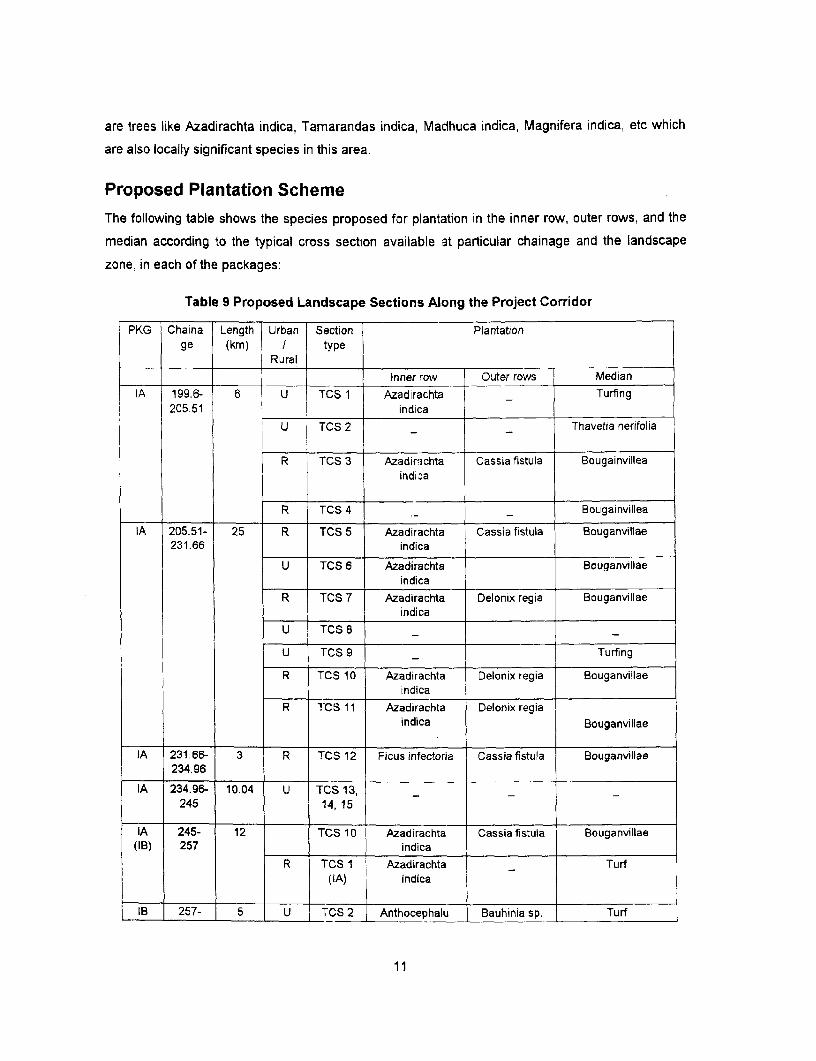
Proposed Plantation Scheme
The following table shows the species proposed for plantation in the inner row, outer rows, and the
median according to the typical cross section available at particular chainage and the landscape
zone, in each of the packages:
Table 9 Proposed Landscape Sections Along the Project Corridor
PKG Chaina Length Urban Section Plantationge (km) I type
Rural
Inner row Outer rows MedianIA 199.6- 6 U TCS 1 Azadirachta Turfing
205.51 indica
U TCS 2 Thavetia nerifolia
R TCS 3 Azadirichta Cassia fistula Bougainvilleaindi.-a
R TCS 4 . Bougainvillea
IA 205.51- 25 R TCS 5 Azadirachta Cassia fistula Bouganvillae231.66 indica
U TCS 6 Azadirachta Bouganvillaeindica
R TCS 7 Azadirachta Delonix regia Bouganvillaeindica
U TCS 8
U TCS 9 Turfing
R TCS 10 Azadirachta Delonix regia Bouganvillaeindica
R T'CS 11 Azadirachta Delonix regiaindica Bouganvillae
IA 231.66- 3 R TCS 12 Ficus infectoria Cassia fistula Bouganvillae234.96
IA 234.965- 10.04 U TCS 13,245 14,15
IA 245- 12 TCS 10 Azadirachta Cassiafistula Bouganvillae(IB) 257 indica
R TCS I Azadirachta Turf(IA) indica
IB 257- 5 U ITCS 2 Anthocephalu Bauhinia sp. Turf
11
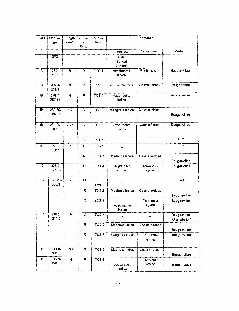
PKG Chaina Length Urban Section Plantationge (km) / type
Rural
Inner row Outer rows Median262 s sp.
(Bengalikadam)
IB 262- 8 R TCS I Azadirachta Bauhinia sp. Bouganvillae269.9 indica
IB 269.9- 9 R TCS 3 Fi cus infectoria Albizzia lebbek Bouganvillae278.7
IB 278.7- 4 R TCS 1 Azadirachta Bouganvillae282.75 indica
IB 282.75- 1.2 R TCS 3 Mangifera indica Albizzia lebbek284.05 Bouganvillae
IB 284.05- 23.5 R TCS 1 Azadirachta Cassia fistula Bouganvillae307.5 indica
U TCS 4 Turf
IC 321- 5 U TCS 1 Turf326.1
R TCS 2 Madhuca indica Cassia nodosa
I_______ BouganvillaeIC 326.1- 1 R TCS 3 Scyzhinium Terminalia Bouganvillae
327.25 cuminii arjuna
IC 327.25- 9 U Turf336.3 TCS 1
R TCS 2 Madhuca indica Cassia nodosa
BouganvillaeR TCS 3 Terminalia Bouganvillae
Azadirachta arjunaindica
IC 336.3- 5 U TCS 1 Bouganvillae341.6 Alternate turf
R TCS 2 Madhuca indica Cassia nodosa
_______ ~~~~~~~~~~~BouganviilaeR TCS 3 Mangifera indica Terminalia Bouganvillae
arjuna
IC 341.6- 0.7 R TCS 2 Madhuca indica Cassia nodosa342.5 Bouganvillae
IC 342.3- 8 R TCS 3 Terminalia350.75 Azadirachta arjuna Bouganvillae
________________________________ indica
12
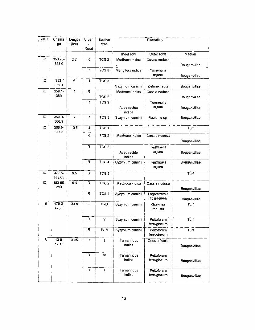
PKG Chaina Length Urban Section Plantationge (km) type
RuralInner row Outer rows Median
IC 350.75- 2.2 R TCS 2 Madhuca indica Cassia nodosa353.0 Bouganvillae
I R , CS 3 Mangifera indica TerminaliaJ ________ arjuna Bouganvillae
IC 353-' 6 U TCS 3359.1 Syzynium cuminii Delonix regia Bouganvillae
IC 359.1- 1 R Madhuca indica Cassia nodosa360 TCS 2 Bouganvillae
R TCS 3 Terminalia
Azadirachta arjuna Bouganvillaeindica
IC I 360.0- 7 R TCS 3 Syzynium cuminii Bauhinia sp. Bouganvillae366.9
IC 366.9- 10.5 U TCS Turf377.5
R TCS 2 Madhuca indica Cassia nodosaBouganvillae
R TCS 3 Terminalia
Azadirachta arjuna Bouganvillaeindica
R TCS 4 Syzynium cuminil Terminalia Bouganvillaearjuna
IC 377.5- 6.5 U TCS 1 Turf383.65
IC 383.65- 9.4 R TCS 2 Madhuca indica Cassia nodosa
393 BouganvillaeR TCS 4 Syzynium cuminii Lagerstromia
flosreginea Bouganvillae
IIB 470.0- 33.8 U '11-D Syzynium cuminii Gravillea Turf473.6 robusta
R V Syzynium cuminii Peltoforum Turfferrugineum
R V-A Syzynium cuminii Peltoforum Turfferrugineum
IIB 13.8- 3.35 R I Tamarindus Cassia fistula17.15 indica Bouganvillae
R VI Tamarindus Peltoforumindica ferrugineum Bouganvillae
R I Tamarindus Peltoforumindica ferrugineum Bouganvillae
13
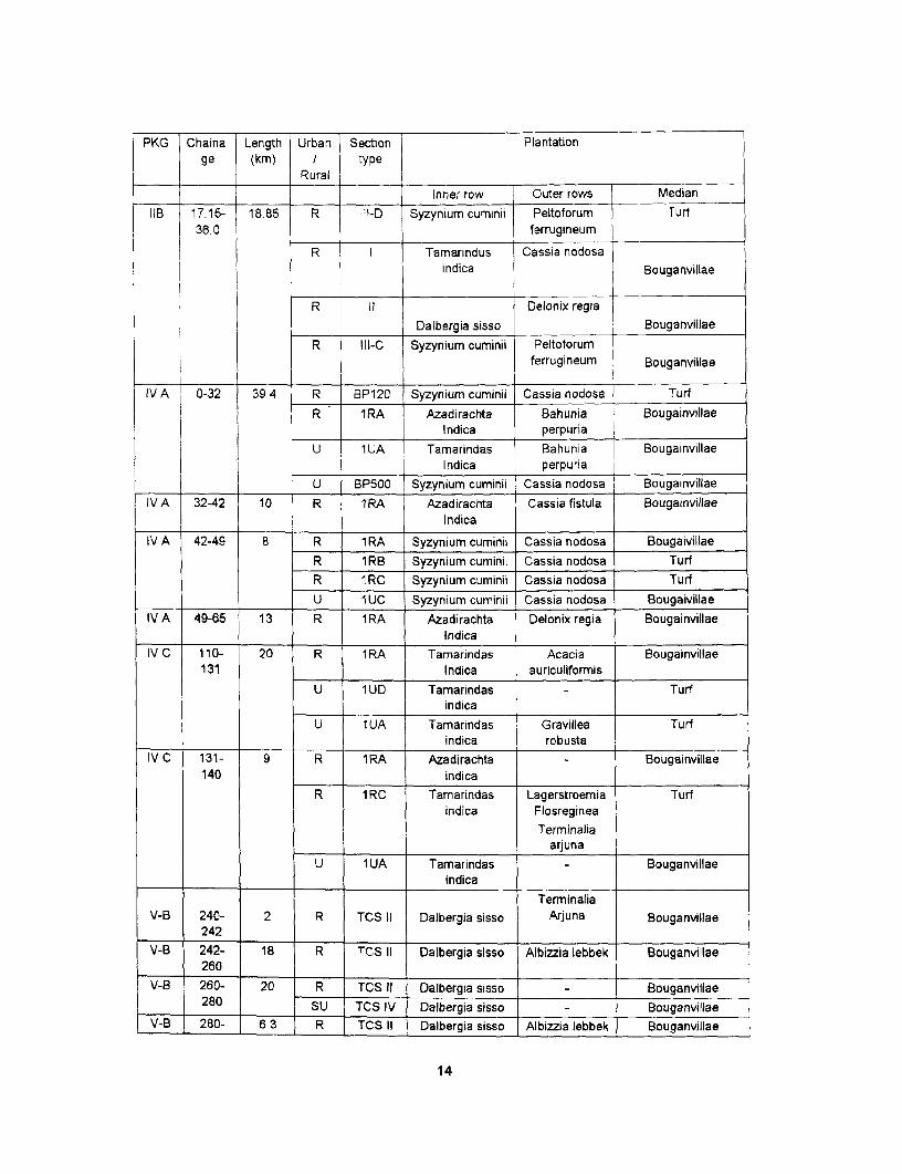
PKG Chaina Length Urban Section Plantationge (km) / type
Rural
Inner row Outer rows MedianIIB 17.15- 18.85 R : ' -D Syzynium cuminii Peltoforum Turf
36.0 ferrugineum
R I Tamarindus [ Cassia nodosaindica Bouganvillae
R 11 Delonix regiaDalbergia sisso Bouganvillae
R IlI-C Syzynium cuminii Peltoforumferrugineum Bouganvillae
IV A 0-32 39.4 R BP120 Syzynium cuminii Cassia nodosa TurfR 1RA Azadirachta Bahunia Bougainvillae
Indica perpuriaU 1UA Tamarindas Bahunia Bougainvillae
Indica perpuriaU BP500 | Syzynium cuminii Cassia nodosa Bougainvillae
IVA 32-42 10 iR 1RA Azadirachta Cassiafistula BougainvillaeIndica
IV A 42-49 8 R 1 RA Syzynium cuminii Cassia nodosa BougaivillaeR 1RB Syzynium cuminii Cassia nodosa TurfR IRC Syzynium cuminii Cassia nodosa TurfU I UC Syzynium cuminii Cassia nodosa Bougaivillae
IVA 49-65 13 R 1 RA Azadirachta Delonix regia BougainvillaeIndica
IV C 110- 20 R 1 RA Tamarindas Acacia Bougainvillae131 Indica auriculiformis
U 1UD Tamarindas Turfindica
U 1 UA Tamarindas Gravillea Turfindica robusta
IV C 131- 9 R 1RA Azadirachta Bougainvillae140 indica
R 1 RC Tamarindas Lagerstroemia Turfindica Flosreginea
Terminaliaarjuna
U 1UA Tamarindas Bouganvillae______ _______ ~~~~ ~~~indica
TerminaliaV-B 240- 2 R TCS II Dalbergia sisso Arjuna Bouganvillae
242V-B 242- 18 R TCS II Dalbergia sisso Albizzia lebbek Bouganvillae
260t V-B 260- 20 R TCS II Dalbergia sisso Bouganvillae
280 SU TCS IV Dalbergia sisso . Bouganvillae| V-B 280- 6.3 R TCS II Dalbergia sisso Albizia lebbek Bouganvillae
14
PKG Chaina Length Urban Soction Plantationge (km) / ype
Rural
Inner row Outer rows Median286.3 l
V-B 286.3- 31.7 R TCS-II Dalbergia sisso - Bouganvillae310 SU TCS-IV Dalbergia sisso Bouganvillae
V-B 318- 2.5 R TCS-II Dalbergia sisso Terminalia Bouganvillae320.5 j arjuna
PLANTATION SPECIFICATIONSThe specifications for carrying out the proposed plantation scheme has been presented for the
following 3 categories :-
(i) Tree planting along the Highway
(ii) Turfing with grasses and shrub planting on median
(iii) Plantation on cultural and historical sites which are of community interest.
TREE PLANTING ALONG THE HIGHWAYS
The execution of the plantation activities will be entrusted to the State Forest Department of Uttar
Pradesh for Packages I-A, I-B, I-C, Il-B and part of IV-.A. For the remaining stretches of the Package
IV-A(Bihar portion), IV-C and V-B the responsibilities of executing the proposed plantation activities
proposed will be with the State Forest Departments of Bihar and Jharkhand. The technical
specification for planting along the Highways are as follows:-
Shade plant [first row)
Distance from edge of shoulder - 6 mts. or 1 mt. away from toe or
embankment whichever is higher
spacing between plant to plant - 12 mts.
Size of the pits
Normal site - 60 x 60 x 60 cms.
For Alkaline soil [Usar] - Pit digging by Augar
Water logged areas - mounds with height varying
depending on the water level.
Species recommended - as per above table for shade plant
No. of plants per km - 84
Height of the plant - Not less than 2 mts
15
2nd and subsequent rows
Distance from edge of shoulder of 2nd row- 9 mts
Subsequent rows from 2 row - at a distance of 3 mts.
Spacing between plant to plant - 3 mts.
Size of the pits:
Normal site - 45 x 45 x 45 cms
Alkaline soil - Pit digging by augar
Water logged areas - mounds with heights varying according to the
water level
Species recommended - As per table 6 and table 7
No. of plants per km - 333 [ for each row]
Height of the plants - more than 1 m
In localities where a really bad patch of usar occurs, there is a need to dug deep pits by
auger [mechanical device] to break the kankar pan down below and replacing the soil by good
quality soil. The soil amender Gypsum 1 to3 kg. depending on the pH along with 2 kg. composite
and sand are filled in the pits. The treatment helps in lowering down the pH and thus enabling better
survival of plants.
z Haphazard mixture of various species just because they happen to be available complicates
subsequent management. Owing to variation both in the rate and form of
> growth of trees mixed, the avenues present a patchy appearance. It is therefore best and most
convenient to use the same species on either side of a road for at least 5 km or so and secure
regularly grown avenues of the same form and type. Such avenues will mature at about the
same time and can be replaced with minimum sacrifice.
> An average spacing of 12 mts. requiring 84 plants per km. and will provide ample growing
space for most species. Too many trees apart from involving higher planting costs, very often
unnecessarily reduce visibility for fast traffic. Excessive dense avenues serve no useful purpose
and apart from affecting the tree growth adversely. It also reduces visibility and proves to be
dangerous to fast moving traffic. Close spacing on curves and crossing can be dangerous so
best plan is to miss a tree or two at such locations.
Protection Measures
Where the availability of the width is only sufficient for single row plantation, the protection will bedone by tree guards of iron/ pre-cast concrete/brick.
For multiple row plantations, protection will be done by barbed wire fencing. Angle iron will be fixedat a spacing of 5 mts. and 3 strand barbed wire will be stretched.
16
Requirement of PlantsThe total stretch under GTRIP is around 422.78 kms. and considering 10% area under urban
limits and 20% areas where width is sufficient only for single row plantation then following is the
requirement of the plants for entire GTRIP:-
Table 10: Plant Requirements for Roadside Plantations - GTRIP8 Packag | length Stretches Urban Other areas Stretches No. of No. of No. ofe No. [km.] not areas where only 1 sufficient fori shade other Total
sufficient sufficient row is possible multiple rows plants plants plantsfor for single [20%] in Km (app.50%) in (on both (on bothplantation row 110%] Km sides) sides)(app.20%) in Kmin Km
IA 50.84 10 5 10 25.84 6861 17209 24070IB 59.02 12 6 12 30.00 8064 19980 28044IC 72.825 14.5 7 14.5 36.825 9799 24525 34324
51.33 10 5 10 25.33 6775 16870 23645IVA 76.10 15 8 15 36.10 9929 24043 33972IVC 31.10 2.5 1 2.5 24.10 4637 - 16051 20688VB 81.57 16 8 16 41.00 10920 27306 38226
TOTAL 422.78 80.002 40.1 81.2 219.2 56985 145984 202969
PLANTING ON THE MEDIAN
The Civil Contractors of the various project packages will carry out the turfing by grasses and
planting on the median.
The surface on the median is to be prepared adequately for shrubs planting or grass sowing. The
grasses and shrubs planting is done to provide a strong surface cover but needs a well-prepared
surface. All masses of loose debris on the median will be removed. Any convexities will be removed
and similarly any concavities are to be filled by good soil. The surface will have sufficient layer of
good quality soil ( upto 45 cms) so as to have better growth and survival of grasses and shrubs.
Grass lines will be used to provide a strong surface cover and will be planted over a well-prepared
surface. Slope treatments using grasses will be allowed to establish properly such that the slopes
PLANTING OF GRASSES
are not subject to undue stress from erosion and mass movement in its initial stages. The sowing of
grasses will create a strengthened surface that will reduce the vulnerability to erosion. Median with a
width of I mts. will have only grasses to strengthen the surface. The contractor will
Ensure that the condition of the site is good enough for the successful establishment of grasses.
supervise all field operations like preparation of surface, sowing of grasses and quality of grassesseeds used.
17
Carry out grassing such that a cover of 25 grams of grass seed per square mt. of surface isachieved.
Carry out seed sowing before the onset of monsoon [May & June] so as to achieve the desiredresults. The watering of the surface will be by tankers till the onset of the monsoon.
Ensure that a mulch of prepared and dried out herbs is laid over the whole seeded area after
sowing, in a thin layer, so that the grass is not affected by direct sunlight and transpiration loss.The grasses recommended for median are Cynodon dactylon, Cythoclinc purpurea, Solanum
nigrum, Xanthium strumerium etc.
PLANTING OF MEDIAN SHRUBS
The plantation on the median will be the responsibility of the contractor. The plants will be procured
from the private nurseries. As the plantation activity will commence in July, 2003 so the contractor
can tie up with the private nurseries for obtaining the necessary plants.
The contractor will plant shrubs [low height plants] as specified in Table 8 at a spacing of 3m cdc.
Only two rows of shrubs will be planted on median of width of 5 m. The plants will be at a spacing of1.5 m from the inner edge of the median.
The contractor will be responsible for the quality of shrubs planted and survival of the plants.
The contractor will ensure the regular watering of the plants as per the activity schedule given inTable 1.4
The height of the plants will not be less than 1 ft. and need to be in polythene bags until the planting.
All plants supplied must be planted within three days of removal from the nursery.
The contractor will be required to water the area in case of insufficient rains after planting.
Size of the pits for planting shrubs: - 45 x 45 x 45 cm.No. of plants per km - 666
Use of compost and manure - 2 kg. per pit.
REQUIREMENTS OF MEDIAN PLANTS
Considering around 20% of the median having a width of 1 m (along the urban sections), median
plantations have been proposed along the remaining sections of the corridor. Accordingly, the
number of plants required will be as follows:-
Table 11: Plants required in the median - GTRIP
Package No. Package length 20% urban + others Balance stretch No. of plants
[having width of required
1.2/1.5mts.]
18
IA 50.84 10 40.84 27200
IB 59.02 12 47.02 62630
IC 72.825 15 57.825 77022
IIB 51.33 10 41.33 55052
IVA 76.10 15 61.10 81386
IVC 31.10 6 25.1 33434
VB 81.57 16 65.57 87340
TOTAL 422.78 84 338.785 424064
PLANTING MATERIAL:
Roadside avenues can be planted up by following:-
(a) Entire transplant
(b) Seedlings in polybags
(c) Cuttings
Entire Transplant
* The plants are retained in the seed beds.
* At the time of planting, plants are carefully jug out with a ball of earth.
* As far as possible, injury to the root system is avoided
* The ball of eastern around each plant can be kept in place by a piece of gunning bag or
straw tied round by a piece of string. The transplants are to be kept moist during transit.
* To avoid transpiration loss, except for the leaves on leading short all other leaves may be
snipped off with a sharp pair of scissors.
The advantage of transplantation is that very tall sized plants [ upto 3 mts] can be directly
planted on the roads and within a short period [ 2 - 3 years] a good avenue can be developed.
Species recommended are Azadirachta indica, Syzynium cuminii, Mangifera indica, Ficus religiosa,
Ficus glomerata, shisam, kanji etc.
Polythene bag plants
Plants are grown in polythene bags in nurseries and are transplanted to the site.
Polythene sheet is removed before planting the saplings.
Cuttings
Cuttings made from aerial roots and branches of species of ficus like Gular, Pakad and
Bargad generally strike roots and rapidly establish themselves.
19
Table 12 Activities Schedule For Plantation along the Highway I Median
Executing Agency (roadside plantations): State Forest Departments, Govt of U.P., Bihar andJharkhand
Executing Agency (median): Civil Contractors of the respective packages
Month Activities to be done
Ist Year 2002-2003 Jan-March 1 Surveying & cleaning of the area
2 Digging of Pits
3 Procurement of Angles Iron and barbed wire2nd Year 2003-2004 April-June 1 Purchase of Farm yard manure
2 Brick guard for 1st row
3 Filling up of Pits with Farm Yard manure and Soil
July-August 1 Transportation of Plants
2 Planting of Saplings
3 Watering
4 Weeding and hoeing
Sep-Nov 1 Weeding and hoeing
2 Watering 4 times a month
Dec-Feb 1 Weeding and hoeing
2 maintenance
March 1 Watenng 4 times a month
3rd Year 2004-2005 April-June 1 Watering 6 times a month
July-August 1 Casualty Replacement ( 20% of the total plants)
2 Weeding
3 maintenance by Mali
Sep-Nov 1 Watering 2 times a month
2 maintenance by Mali
Dec-Feb 1 maintenance by Mali
March 1 Watering 4 times a month
2 maintenance by Mali4th Year 2005-2006 April-March 1 Watering
2 Casualty Replacement ( 10% of the total plants)
3 maintenance by Mali
20
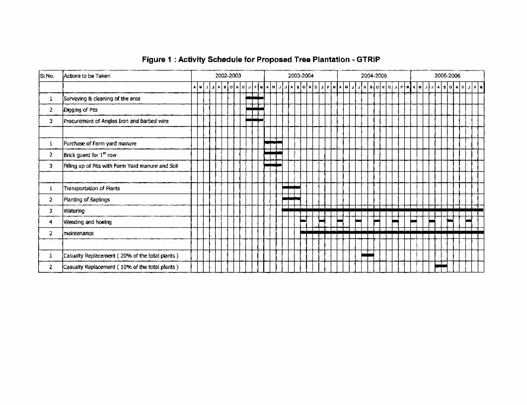
Figure 1: Activity Schedule for Proposed Tree Plantation - GTRIP
SI.No. Actions to be Taken 2002-2003 2003-2004 2004-2005 2005-2006
A M J J A S O N IFIM A M J JJA S ON D JF M A M J J A S|O|N| OJ|F|M A|M|J|J|A|S|ON|D J| FIM
I Surveying & cleaning of the area
2 Digging of Pits
3 Procurement of Angles Iron and barbed wire
1 Purchase of Farm yard manure
2 Brick guard for lSt row
3 Filling up of Pits with Farm Yard manur and Soil
1 Transportation of Plants
2 Planting of Saplings
3 Watering
4 Weeding and hoeing
2 maintenance
1 Casualty Replacement ( 20% of the total plants ) _ _
2 Casualty Replacement ( 10% of the total plants )

LANDSCAPING AT SPECIFIC IDENTIFIED SITESLandscaping At Road Junction/lntersection And Traffic Islands
Road intersections are main nodal spaces and are of vital importance in terms of road aesthetics.
Proper landscaping of the traffic islands and the surrounding areas shall integrate these features
with the surrounding landscape. The lay out of traffic intersections shall be fixed by the traffic needs
of the junction. The landscape design has considered the basic standards of height limitations,
approprate sight lines and other geometric design elements that are applicable to each type of traffic
intersection.
Considering the high intensity of traffic volume in such areas, the proposed treatment has been
designed in such a way that minimum attention is needed in the maintenance of the landscape
features. Stability of the landscape items also forms a part of the design proposal.
The major road junctions identified for enhancement along the Grand Trunk road are as per
following table:
Table 1 3Major Road Junctions identified for enhancement
Pack Locatio Type of Junction Remarksage n1A 200.75 Cross Junction Rambagh Crossing, Flyover proposedIA 231.210 Y Junction, Major junction Landscaping required1A 232.10 Y junction, start of Raja Ka Tal Bypass Landscaping required1A 235.4 Y junction, end of Raja Ka Tal Bypass Landscaping required
1B 270.277 Y Junction Bypass Cross road, major junction.5
1 B 282.400 Y junction Bypass Ukrend meets here, major junction.IB 283.700 Cross road Intersection of a major junction.IC 326.125 Y Junction Start of Ekdil BypassIC 327.0 Y Junction End of Ekdil BypassiC 336.0 Y Junction Start of Bakewar Bypass1C 339.3 Y Junction End of Bakewar BypassIC 342.5 Y Junction Start of Ujhayani BypassIC 350.5 Y Junction End of Ujhayani Bypass1C 347.6 Y Junction End of AnatRam BypassiC 353.05 Y Junction Start of Ajitmal BypassIC 358.7 Y Junction End of Ajitmal BypassiC 360.4 Y Junction Start of Bhikepur Bypass1 C 363.45 Y Junction End of Bhikepur Bypass1 C 366.45 Y Junction End of Muradganj Bypass1 C 371.500 Cross roads, Major junctionIC 378.300 Cross roads, Major junctionIl-B 484.100 Cross roads Major junction near Police Station +
21
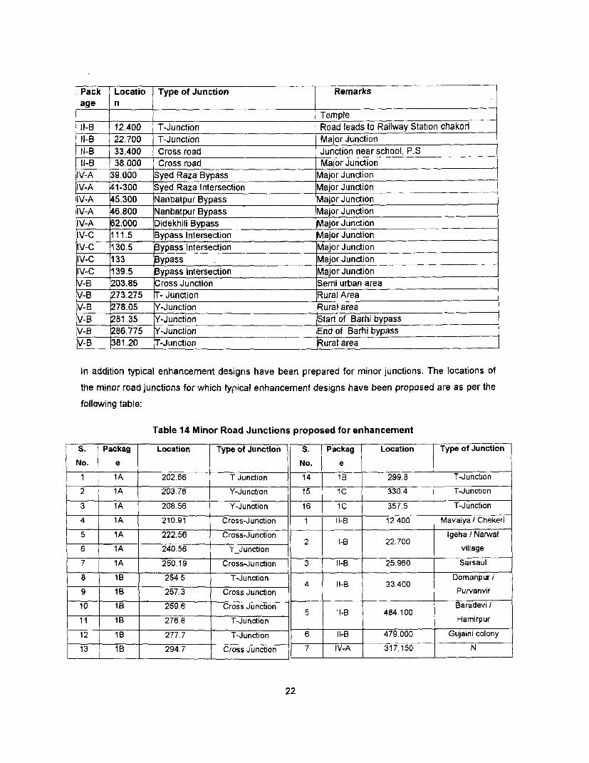
Pack Locatio Type of Junction Rage n
TempleIl-B 12.400 T-Junction Road leads to Railway Station chakornIl-B 22.700 T-Junction Major JunctionIl-B 33.400 Cross road Junction near school, P.SIl-B 38.000 Cross road Major Junction
IV-A 39.000 Syed Raza Bypass Major JunctionIV-A 41-300 Syed Raza Intersection Major JunctionIV-A 45.300 Nanbatpur Bypass Major JunctionIV-A 46.800 Nanbatpur Bypass Major JunctionIV-A 62.000 Didekhili Bypass Major JunctionIV-C 111.5 Bypass Intersection Major JunctionIV-C 130.5 Bypass Intersection Major Junction
IV-C 133 Bypass Major JunctionIV-C 139.5 Bypass Intersection Major JunctionV-B 203.85 Cross Junction Semi urban areaV-B 273.275 T- Junction Rural Area
-B 278.05 Y-Junction _Rural areaV-B 281.35 Y-Junction Start of Barhi bypassV-B 86.775 -Junction End of Barhi bypass\-B 381.20 T-Junction Rural area
In addition typical enhancement designs have been prepared for minor junctions. The locations of
the minor road junctions for which typical enhancement designs have been proposed are as per thefollowing table:
Table 14 Minor Road Junctions proposed for enhancement
S.. Packag Location Type of Junction S. Packag Location Type of JunctionNo. e No. e1 I1A 202.66 T Junction 14 1B 299.8 T-Junction2 1A 203.76 Y-Junction 15 1C 330.4 T-Junction3 1A 208.56 Y-Junction 16 1 C 357.5 T-Junction4 1A 210.91 Cross-Junction 1 Il-B 12.400 Mavaiya I Chekeri5 1A 222.56 Cross-Junction 2 I-B 22,700 Igeha / Narwal6 1A 240.56 Y_Junction village7 1A 250.19 Cross-Junction 3 I-B 25.960 Sarsaul8 1 8 254.5 T-Junction Domanpur I9 IlB 257.3 Cross Junction Purvanvir10 1B 259.6 Cross Junction 5 I-B 484.100 Baradevi I1 1 B 276.8 T-Junction Hamirpur12 1B 277.7 T-Junction 6 Il-B 479.000 Gujaini colony13 1B 294.7 Cross Junction 7 IV-A 317.150 N
22
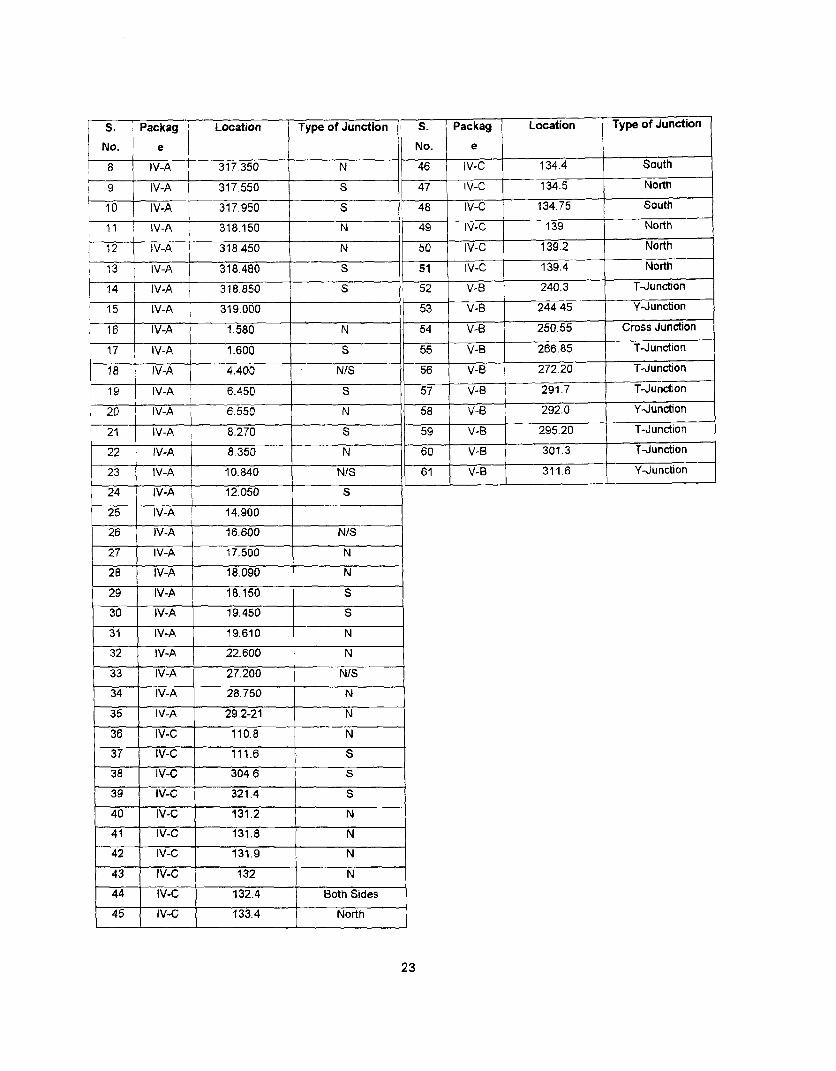
|S. | Packag Location Type of Junction S. Packag Location Type of JunctionNo. e No. e8 1 V-A 317.350 N 46 IV-C 134.4 South9 IV-A 317.550 S 47 IV-C 134.5 North10 IV-A 317.950 S 48 IV-C 134.75 South11 IV-A 318.150 N 49 IV-C 139 North12 IV-A 318.450 N 50 IV-C 139.2 North13 V-A 318.480 S 51 V-C 139.4 North14 IV-A 318.850 S 52 V-B 240.3 T-Junction15 IV-A 319.000 53 V-B 244.45 Y-Junction16 IV-A 1.580 N 54 V-B 250.55 Cross Junction17 IV-A 1.600 S 55 V-B 266.85 T-Junction1 8 IV-A 4.400 N/S 56 V-B 272.20 T-Junction19 IV-A 6.450 S 57 V-B 291.7 T-Junction20 IV-A 6.550 N 58 V-B 292.0 Y-Junction21 IV-A 1 8.270 S 59 V-B 295.20 T-Junction22 IV-A 8.350 N 60 V-B 301.3 T-Junction23 IV-A 10.840 N/S 61 V-B 311.6 Y-JuncRion24 IV-A 12.050 S
25 IV-A 14.900
26 IV-A 16.600 N/S
27 IV-A 17.500 N
28 IV-A 18.090 N
29 IV-A 18.150 S
30 IV-A 19.450 5
31 IV-A 19.610 N32 IV-A 22.600 N
33 IV-A 27.200 N/S34 IV-A 28.750 N
35 IV-A 29.2-21 N
36 tIV-C 110.8 N37 IV-C 111.6 S38 IV-C 304.6 S
39 IV-C 321.4 S
40 IV-C 131.2 N41 lV-C 131.8 N42 IV-C 131.9 N
43 IV-C 132 N
44 IV-C 132.4 Both Sides45 IV-C 133.4 North
23
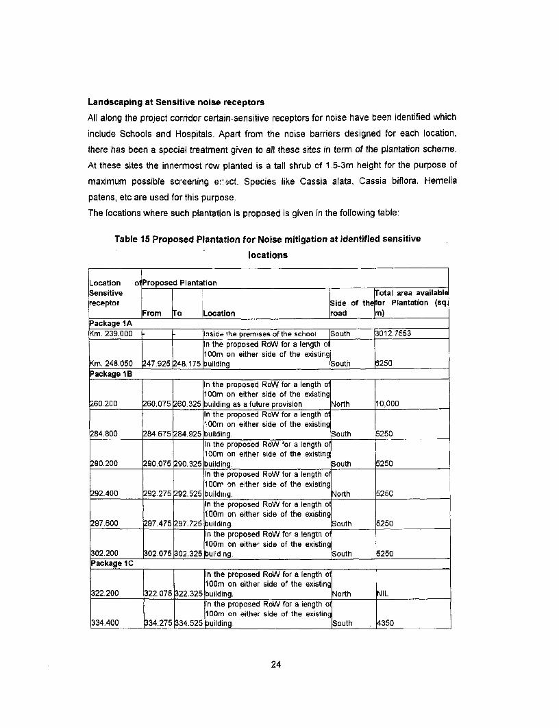
Landscaping at Sensitive noise receptors
All along the project corridor certain.sensitive receptors for noise have been identified which
include Schools and Hospitals. Apart from the noise barriers designed for each location,
there has been a special treatment given to all these sites in term of the plantation scheme.
At these sites the innermost row planted is a tall shrub of 1.5-3m height for the purpose of
maximum possible screening e-.ct. Species like Cassia alata, Cassia biflora, Hemelia
patens, etc are used for this purpose.
The locations where such plantation is proposed is given in the following table:
Table 15 Proposed Plantation for Noise mitigation at identified sensitive
locations
Location olProposed PlantationSensitive Total area availablereceptor Side of the for Plantation (sq
From To Location road m)Package 1AKm. 239.000 -l Insid& ihe premises of the school South 3012.7553
In the proposed RoW for a length o100m on either side of the existing
Km. 248.050 247.925 248.175 building South 6250Package 1B
In the proposed RoW for a length o100m on either side of the existing
260.200 260.075 260.325 building as a future provision North 10,000In the proposed RoW for a length oa100m on either side of the existing
284.800 284.675 284.925 building. South 5250In the proposed RoW for a length o100m on either side of the existing
290.200 290.075 90.325 building. South 5250In the proposed RoW for a length olOOrr on either side of the existing
292.400 292.275 92.525 buildin g. North 5250In the proposed RoW for a length o100m on either side of the existing
297.600 297.475 297.725 building. South 5250In the proposed RoW for a length ol100m on either side of the existing
302.200 302.075 302.325 building. South 5250Package IC
In the proposed RoW for a length ol100m on either side of the existing
322.200 322.075 22.325 building. North NILIn the proposed RoW for a length of100m on either side of the existing
334.400 334.275 334.525 building. South 4350
24
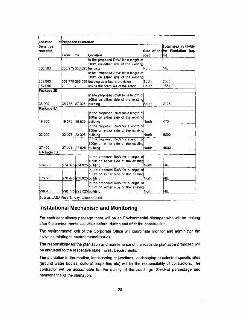
Location o Proposed PlantationSensitive Total area availablereceptor Side of the for Plantation (sq
From To Location road m)In the proposed RoW for a length of100m on either side of the existing
336.100 335.975 336.225 building. North NILIn th' 1roposed RoW for a length o100m on either side of the existing
368.900 368.775 369.025 building as a future provision South 2500384.000 Inside the premises of the school SouthPackage 2B
1 f In the proposed RoW for a length ofl 100m on either side of the existing
36.900 j36.775 37.025 building South 2125Package 4A
In the proposed RoW for a length o100m on either side of the existing
19.700 19.575 19.825 building North 475In the proposed RoW for a length o1 00m on either side of the existing
23.200 23.075 23.325 building North 5000In the 'roposed RoW for a length o100m on either side of the existing
27.400 27.275 27.525 building North 5000Package 5B
In the proposed RoW for a length of100m on either side of the existing
274.800 274.675 274.925 building North NILIn the proposed RoW for a length ol100m on either side of the existing
276500 276.475 276.625 building North NILIn the proposed RoW for a length ol100m on either side of the existing
290.900 290.775 291.025 building North NIL
Source: LASA Field Survey, October 2000.
Institutional Mechanism and Monitoring
For each consultancy package there will be an Environmental Manager who will be lookingafter the environmental activities before, during and after the construction.
The environmental cell of the Corporate Office will coordinate monitor and administer theactivities relating to environmental issues.
The responsibility for the plantation and maintenance of the roadside plantation proposed willbe entrusted to the respective state Forest Departments.
The plantation in the median, landscaping at junctions, landscaping at selected specific sites(around water bodies, cultural properties etc) will be the responsibility of contractors. Thecontractor will be accountable for the quality of the seedlings, Survival percentage andmaintenance of the plantation.
25
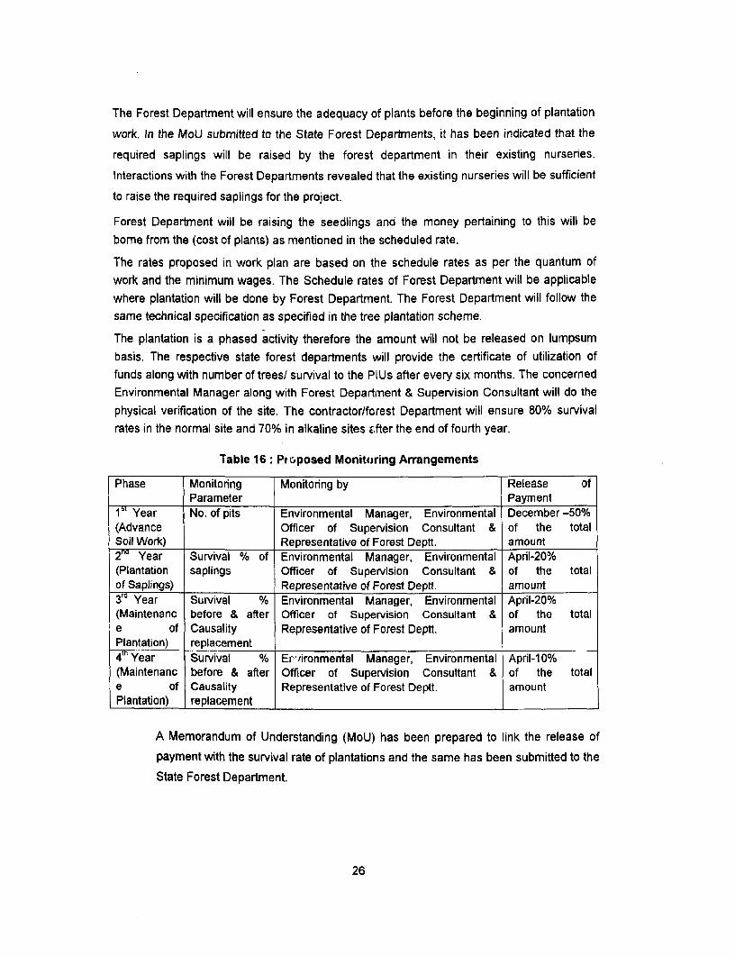
The Forest Department will ensure the adequacy of plants before the beginning of plantation
work. In the MoU submitted to the State Forest Departments, it has been indicated that the
required saplings will be raised by the forest department in their existing nurseries.
Interactions with the Forest Departments revealed that the existing nurseries will be sufficient
to raise the required saplings for the project.
Forest Department will be raising the seedlings and the money pertaining to this will bebome from the (cost of plants) as mentioned in the scheduled rate.
The rates proposed in work plan are based on the schedule rates as per the quantum ofwork and the minimum wages. The Schedule rates of Forest Department will be applicablewhere plantation will be done by Forest Department. The Forest Department will follow thesame technical specification as specified in the tree plantation scheme.
The plantation is a phased activity therefore the amount will not be released on lumpsumbasis. The respective state forest departments will provide the certificate of utilization offunds along with number of trees/ survival to the PlUs after every six months. The concernedEnvironmental Manager along with Forest Department & Supervision Consultant will do thephysical verification of the site. The contractor/forest Department will ensure 80% survivalrates in the normal site and 70% in alkaline sites after the end of fourth year.
Table 16: Pi vposed Monitoring Arrangements
Phase Monitoring Monitoring by Release ofParameter Payment
1 Year No. of pits Environmental Manager, Environmental December -50%(Advance Officer of Supervision Consultant & of the totalSoil Work) Representative of Forest Deptt. amount2 Year Survival % of Environmental Manager, Environmental April-20%(Plantation saplings Officer of Supervision Consultant & of the totalof Saplings) Representative of Forest Deptt. amount3`Year Survival % Environmental Manager, Environmental April-20%(Maintenanc before & after Officer of Supervision Consultant & of the totale of Causality Representative of Forest Deptt. amountPlantation) replacement .4 Year Survival % Er'ironmental Manager, Environmental April-1 0%(Maintenanc before & after Officer of Supervision Consultant & of the totale of Causality Representative of Forest Deptt. amountPlantation) replacement
A Memorandum of Understanding (MoU) has been prepared to link the release of
payment with the survival rate of plantations and the same has been submitted to the
State Forest Department.
26
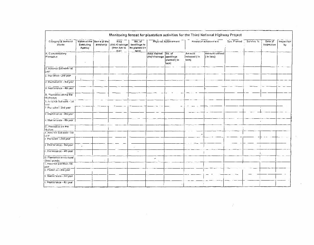
Monitoring format for plantation activities for the Third National Highway Project
Catogory & items of Nameofthe Name of the Area No. of Physlcal Achlevement Financial achievement Sp5. Planted Survival % Date of nspection
Works Executing area/strip (Ha)-tChalnage seedlings to Inspection by
Agency (from km to be planted iln
__ _ KmL__ a~~~cs __. ___ |___
A. Compensatory Area planted No. of Amount Amount utillsed
Plantation (Ha)lchalnage seedlings released (In (In las)
planted (In lacs)
lacs)
1. Advance Soil work-tstyear
. Piantation - 2nd year
3. Maintenance - 3rd year
4 Ivia ntenarce - 4th year
B. Plantation- along the
Highways.i h.ay ___ __I ____ ____ ._______ _______ ____
1. Advance Soil work - 1styac r _._ _.
2. Pnieta!ion - 2nd year
3 Maintenance - 3rd year
Maintenance - 4th year
C. Plantation orn the'Aadlan
1. Advance Soil work - 1 st
2. Plantation - 2nid year
3. Maintenance - 3rd year
4. Maintenance - 41n year
0. Plantatlon on cultural
Sitosl ponds __ ._ _ .
1. Advance Soil Work 1styear _.___2. Plantation - 2nd year
3. Mailenance - 3rd year
4 Maintenance - 4th yeaL
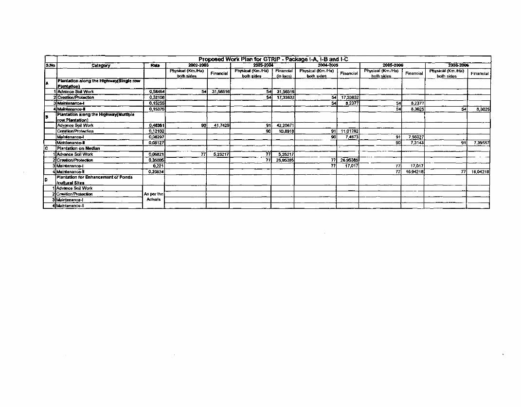
_ ____________________ Pro osed Work Plan for GTRIP - Packa Ie l-A, I-B and I-CSNo Categoy Rate 2002-2003 20032004 2004-2006 2005-2006 2005-2006
Physical (Km JHa) FncilPhysical (Km./Hla) Financial Physical (K<m ./Ha) FiacalPhysical (Km./Ha) FncilPhysical (Km./Ha) iaca
_ _________________________=___________ both sides both sides in lacsi both sides _ _ both sides both sides
A Plantation along the Htghway(Slngle row_ pl antatni __
1 Advance Soil Work 0,58454 54 31.56516 54 31,56516
2 Creation/Protection 0,32108 54 17,33832 54 17,33832
3 Maintenance-I 0.15255 54 8,2377 54 8,2377
4 abintenance-lI 0,15375 _ 54 8,3025 54 8,3025
Plantation along the Hlghway(Mufflplerow Plantatlonl
I
_ Advance Soil Work 0.46381 90 41,7429 91 42,20671
Creation/Protection 0,12102 . 90 10.8918 91 11,01282
_ Mainlenance-I 0,08297 90 7,4673 91 7.55027 _
Waintenance-t1 0,08127 0_ ___ 9 7,3143 91 7,39557
C Plantation on Median1 Advance Soil Work 0,06821 77 5.25217 77 5,25217
2 Creation/Protection 0.35005 _ 7 26,95385 77 26,95385 ____
3 Maintenance-I 0.221 77 17,017 77 17,017 1
4 Maintenance-ll 0,20834 __ _ 77 16,04218 77 16,04218
D Plantation for Enhancement of PondsIkultural Sites
1 Advance Soil Work2 Creation/Protection As per the
3 Maintenance-I Actuals
4 Maintenance-It

-____ Prosed Work Plan for GTRIP - Package 11BS.No Category Rate 2002-2003 2003-2004 2004-2005 2005-2006 2005-2006
Physical (Kmr.Ha) Financial Physical (Km./Ha) Financial Physical (Km./Ha) Financial Physical (Km./Ha) Financial Physical (Km./Ha) Financial
Plantation along the Highway(Single
A row Plantation) .
I Advance Soil Work 058454 18 10,52172 18 10,52172
2 Creation/Protection 0,32108 18 5,77944 18 5,77944 _
3 Maintenance-I 0,15255 1 18 2,7459 18 2,7459
4 Maintenance-lI 0,153751 18 2,7675 1 8 2,7675
Plantation along the Highway(Multiple
B row Plantation) Advance Soil Work 0,46381 26 12,05906 25 11,59525
Creation/Protection 0,12102 26 3,14652 25 3,0255
Maintenance-I 0,08297 26 2,15722 25 2,07425
Maintenance-lI 0,08127 26 2,11302 25 2,03175
C Plantation on Median1 Advance Soil Work 0,06821 _ 21 1,43241 20 1,3642
2 Cr tetion/Protection 0,35005 21 _ 5105 20 7,001 _
3 Maintenance-I 0,221 21 4,641 20 4,42
4 Maintenance-lI 0,20834 ._ 21 4,37514 20 4,1668
Plantation for Enhancement of Ponds
D /cultural Sites1 Advance Soil Work2 Creation/Protection As per
3 Maintenance-I the
4 Maintenance-l1 Actuals
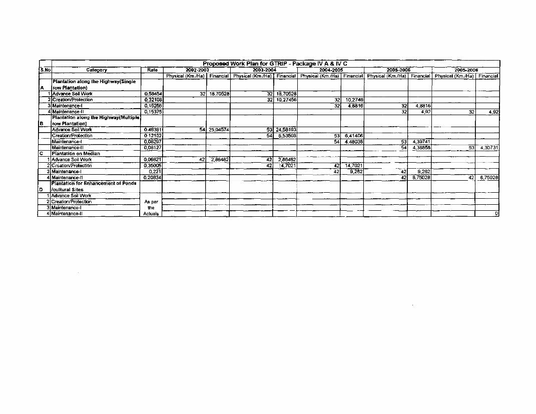
Proposed Work Plan for GTRIP - Package IV A & IV C
S.No Category Rate 2002-2003 2003.2004 2004-2005 2005-2006 2005-2006
.________________________ . _ _ Physical (Krn./Ha) Financial Physical (Kmr/Ha) Financial Physical (Km/.Ha) Financial Physical (Km./Ha) Financial Physical (Km./Ha) Financial
Plantation along the Highway(Single
A row Plantation)1 Advance Soil Work 0,58454 32 18,70528 32 18,70528
2 Creation/Protection 0,32108 . 32 10,27456 32 10,2746
3 Maintenance-I 0,15255 1 32 4,8816 32 4,8816
4 Maintenance-ll 0,15375 32 4,92 32 4,92
Plantation along the Highway(Multiple
B row Plantation)Advance Soil Work 0,46381 54 25,04574 53 24,58193 _ _
Creation/Protection 0,12102 _ _ 54 6,53508 53 6,41406,
M Maintenance-I 0,08297 . 54 4,48038 53 4,39741
Maintenance-lI 0,08127 _ _ 54 4,38858 53 4,30731
C Plantation on Median _ ______=_____ ______
1 Advance Soil Work 0,06821 42 2,86482 42 2,86482
2 Crsation/Protection 0,35005 42 4,7021 42 14,7021
3 Maintenance-I 0,221 _ 42 9,282 42 9,282
4 Maintenance-tl 0,20834 _ 42 8,75028 42 8,75028
Plantation for Enhancement of Ponds
D /cultural Sites _
1 Advance Soil Work2 Creation/Protection As per _
3 Maintenance-I the _
4 Maintenance-lI Actuals _ C
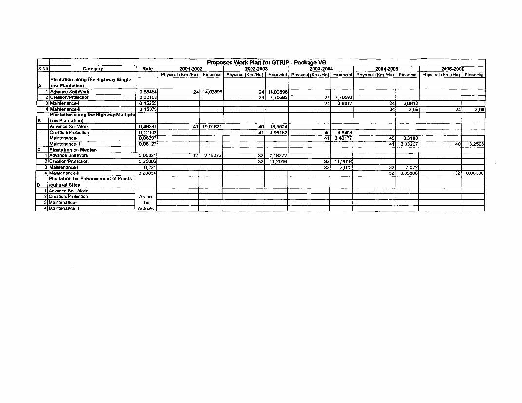
= _____________________ _____ Propc sed Work Plan for GTRIP - Package VBS.No Category Rate 2001-2002 2002-2003 2003-2004 2004-2005 2005-2006
= ________________________________ Physical (Krn./Ha) Financial Physical (K./Ha) Financial Physical (Km./Ha) Financial Physical (Km./Ha) Financial Physical (Km./Ha) Financial
Plantation along the Highway(SingleA row Plantation) _
1 Advance Soil Work 0.58454 24 14,02896 24 14,02896
2 Creation/Protection 0,32108o 24 7,70592 24 7,70592
3 Maintenance-I 0,15255 24 3,6612 24 3,6612
4 Maintenance-lI 0,15375 . 24 3,69 24 3,69
Plantation along the Highway(MultipleB row Plantation)
_ Advance Soil Work 0,46381 41 19,01621 40 18,5524
Creation/Protection 0,12102 41 4,96182 40 4,8408
Maintenance-I 0,08297 41 3,40177 40 3,3188
Maintenance-lI 0,08127 _ 41 3,33207 40 3,2508
C Plantation on Median1 Advance Soil Work 0,06821 32 2,18272 32 2,18272
2 Creation/Protection 0,35005 32 _11,2016 32 11,2016
3 Maintenance-I 0,221 32 7,072 32 7,072
4 Maintenance-ll 0,20834 _ 32 6,66688 32 6,66688
Plantation for Enhancement of Ponds
D /cultural Sites .
1 Advance Soil Work2 Creation/Protection As per3 Maintenance-I the
4 Maintenance-lI Actuals
_ _ _ ________ Single row Plantation Activity Year wise starting from Jan 2001 along the Highway for all the Packa g _e_s
Year Activity No Description of Work for Single row Plantation Unit Rate(Rs) Quantity(per Km.) Total Amount(in Rs.)1 Survey and alignment 500.002 Cleanina of Area 1000.0C
i3 Dgging of Pits forIst__Year____---- (a) Shade Plants (60cmX6OcmX6Ocm) 8.00 84 672OCi
4 Purchase of tree Guard 500.00 84 42000.00_Total __ __ 44172.00
____________ j Conticency (5%'o) __ 2208.60___________________ ~Grand Total 46380.60
1 Porclhase of Farm Yard manure/chemicals 2 00 84 168.002 Filling up Pits 1 00 84 8400_3Fixing up tree guard 40.00 84 3360 004 Cost of Plants(including 10% more due to mortality on transit and 15 00 94 1410.005 Transportation of Planits 3 00 94 282.00
2nd Year 6 e Plantation 1.50 84 - _ 126.007 Weeding 1.00 252 252 008 Irrigation between Sep-March( 16 times) 1.00 1344 1344 0091Watch &Ward for nine Months 500.00 12 6000 00
iote al 13026.00Contig6n0yE_(5'%) - - 1357730
l____ Grand Total 13677.30
1 Casualty Repalacement(20% of the total)- _. (a) Cost of the Plant 15.00 17 255.00
.___________ (b Toransportation of Plants 3.00 17 51.002 Weeding-& hoeing 1.00 252 252 00
3rd Year 3 Irrig_ation( 6times) 1.00 1344 1344.004 Watch &Ward(for 12months) 500.00 12 6000.00
Total . 7902.00_ _.__._ Conti qcncy 5/ _ __ _ .- _ _ _ 395.10
__._____ Grand Total ______--_--___-_-_8297.10
_. 1 _ 4-- _ i Casuality Repalacernent(10% of theoft1500tota)________________ (a) Cost of the Plant X_15 00 _ ________ 120 00
Ith Year (b) Transportation of Plants 3.00 8 24OC2IWeedr & hoeing 1 0O 252 5 _-_ 252_00
___ 3Irrigation(36times) 1.00 1344 134400l____ __________ 4 Watch &Ward(for 12months) 500.00 12 6000 00
.. __ I _____________ Total _ __ __ I_ 7740 00-______ _ ____I ________ Contigency (5%) 38700
_____ 1r______________ Grand Total I_ 8127.00
I____ ___________ Multiple row Plantation Activity Year wise starting from Jan 2001 along e Highway for all the Packages
Year Activity No Description of Work for Mutiple row Plantation Unit Rate(Rs) Quantity( per Km.) Total Amount( in Rs.)1 nurviy and 2aignmenV 500.00
----C-an ngea _ 200"01 _ 200;0003 DiUing of Pits for
_ (§Shade Plants (60cmX60cmX60cm) 8,00 84 672.00lstYear (b) Other Plants (45cmX45cmX45cm) 6 00 333 1993.00
1st -Anl Iron sacing of 4 metr 150.00 250 37500.005 Barbed Wire 2600000 0.5 13000.00
Total 53170.00Contigency (5%) 2658.50Grand Total -__ 55828.50
1 _ Purchase of Farm Yard manurelchemicals ____ __ _ 2.00 417 834 002 Filling up Pits * 41 417_00_
.3 Fixing up angle iron 20 00 250 5300_O4 Stretching of barbed wire 3000 005 Cost of Plants(including 10.i/ more due to mortality on transit and 15.00 460 6900 006 Transportation of Plants _ 3.00 460 1380.00
2nd Year __ 7 Plantation _ _ 1.50 417 625.508 Weeding(3times) 1.00 1251 125100
.____ . _ Irrigation between Sep-March(16 times) - 1.00 6672 6672.0010 Watch &W\ard for nine Months 500 009 4500.00
______ Total 30579.50_ Contigency (5°/)_ 1528.98Grand Total _3_2___ ____ _ .
1 . __ _ _Casualty Repalacement(20% of the total) _
___________1TaT-VjCsti ofthe Pi_t_ 15.W 80 1200_CiO_-2 b) Transportation of Plants 3.00 80 240.00
2 _ _ Weeding & hoeing 1.00 1251 1251 003rd Year _ _ rrigabon(1Gtimes_ 1.00 6672 6672000
4 Watch &Ward(for 12months) 500.00 12 6000.00____ Total ____________________ _____________________ 15363.00
_______ _ Co_igency;5 ) _ . 768 15=_ 1 _ _ _ __ CGrand Toal _ 16131.15 _-
I ___1______asualtyRepa ement( 10% of the otal} _ _ | __ _(a) Cost of the Plant 15.00 40 60C.00
i_ __ _1__ 5<(b) Transpcrtation of Plants 3.00 _ 40 _ _ 120002 Weeding & hoeing _-___ 1.00 1251 _ 1251 00
4th Yrcar | IrriLat 1.00 6672 6672 00I 1 _ 4 Watch &Ward for 12months) 500.00 12 6000.00
_ .al ______________________________________________ .___otat___ 14643.00-_______Contigency (5%__) 732.15
.,__ t d_._ i _____Gra__dI__t 15375.15_ _ _ _____ _ _ _ _ _ _ _ _ _ _ _ _ _ _ _ _ _ _ _ _ _ _ _ _ _
__ _ _____ ________ Piantation Activity in the Median Year wise starting from Jan 2001 along the Highwa I for all the Packages __ _
___Year A__ctivity i No _ HDescription of Work for in the Median Plantation Unit Rate(Rs) Qt_antity( per Kim) Total Amount( in Rs.)|1 ._ _ 1 SLurvey and alignment -_ 50000
-- ___________ 2 Cleaning of Area _ 000.0031 Digg _ of _s fore
Ist Year (b Other Plants (45cmX45cmX45cm) 600 666 399600| ______________ 0Total _ 6496.00
_Contigency (5%) _ 324.80Grand Total 6820.80
_________ 1 Purchase of Farm Yard manure/chemicals 2.00 666 1332.002 Fillin up Pits 1.00 666 666.0051_Cost of Plants(incluc g 10% more due to mortality on transit and 15.00 733 1989 .006 Transportation of Plants 3.00 733 2199.007_ Plantation 1,50 666 _ 999.00
2nd Year 8 Weeding (3times) 1.00 '1998 1998.009 Irrigation between Sep-March(16 times) 1.00 10656 10656.00
10 Watch &Ward for nine Months 500.00 9 4500.00_____________ Total 33339.00
Contigency (5%) 1666.95Grand Total _ 35005.95
I Casualty Repalacement(20% of the total)(a) Cost of the Plant 15.00 133 1998.00(b) Transportation of Plants 3.00 133 399.00
_________ 2 Weeding & hoeing 1.00 1998 _ _ 1999.003rd Year _ _Hioi __6_nmes)o. 1-.0 10656 _ - 066 6 00
____________ 4!.atch &Ward(for 12months) 500.00 12 6000 00K-Total __ _ _ _ _ _ _ _ _21051.00
_____________j Contigency (5%) _ _ 052.55Grand Total 22103.55
1 Casualty Repalacement(10% of the total)_______ -( (a) Cost of the Plant 15.00 _66 990 .O
_ (b) Transportation of Plants 3.00 66 198.0021Weeding & hoeing 1.00 1998 1998.00
4th Year r _ _ 3 Irrigation(16times) 1.00 10656 10656.00K _ 4WVatch &Ward(for 12months) 500.00 12 6000.00
f_____ - ' I |Total l _- _ 19842.00- -__.___ Contigency L5%/o __ __ __ -_ 992.10
IGrand T-otal __ 20834.10
3