toms southampton cruise port guide: england · toms southampton cruise port guide: england 1) maps...
TRANSCRIPT
Toms Southampton Cruise Port Guide: England1) Maps of cruise terminals, ferry boat docks, port gates, 2) Travel options between the port and London, 3) Southampton walking tour maps for the port area.
Southampton is 80 miles southwest of London and 65 milesfrom Heathrow Airport. It's ~ an 80-minute ride to LondonHeathrow airport. However, there may be delays due to trafficand airport security. Check with your ship re the schedule fortransfers. The Ruby Princess airport transfer required aminimum of 5 hours from the time the ship docks to your flightdeparture time. Southampton has a rich history. Some of England’s best-preserved medieval Town Walls are next to the cruise terminals.Explore the old town, walk the medieval walls. The SeaCityMuseum Titanic exhibit is a must visit. This port guide includes port maps and details on the location ofcruise terminals and berths in the Southampton Port. Optionsfor travel between cruise ships and London Heathrow airport aredescribed via cab, bus, train, etc. This guide lists GPS coordinates for the cruise terminals andpoints of interest to help you determine travel route, time, anddistance to any destination.I've included information on rental car agencies near the port. For those who have time to explore Southampton, I haveincluded information on the Old Town Historic Area walkingtour, the Titanic Memorial Walk, shopping areas, museums, andother points of interest. Subject PagesAerial view of the port and the “official” port map showing cruise ship terminals, berths, & dock gates 2-3Port Authority website, ship schedule, port “new brochure”, description of cruise terminal locations 4GPS coordinates for the port 5Travel options between Southampton Cruise Terminals and London Heathrow Airport 5-7Southampton International Airport (SOU), Southampton Central Train Station (SOU) 7Car rental in Southampton 8-9Estimating taxi fares in Southampton 9-10Things to see and do in Southampton – shopping, museums, art, monuments 10-11Map of Southampton & photos 12-13Walking Tour of Old Town 14-15Titanic memorial walk 15-17Public bus service 17User Feedback, Copyright Notice, Terms and Conditions for use of Toms Port Guides 18
CAVEAT
Information contained herein is believed to be accurate. PLEASE verify the information you use for your travelplans. Opinions expressed are my own. This port guide is protected by copyright law - see the last page of thisguide for legal notices.Tom Sheridan
NOTE: I would like to thank Mick Berry and John Winter for their help on this port guide.
Southampton-07-15-2014 Page 1 of 18 For more guides, see www.TomsPortGuides.com
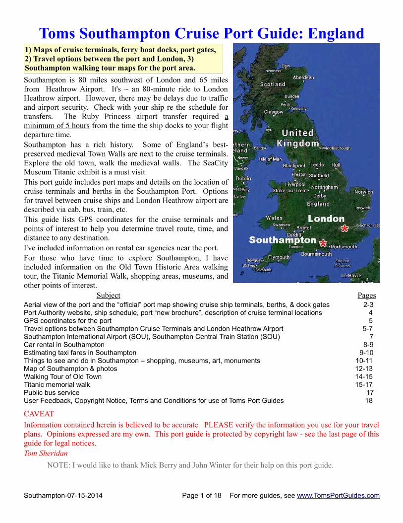
Aerial View of Port from the Southampton Port “New Brochure”
Download the “New Brochure” at h ttp://www.southamptonvts.co.uk/Live_Information/Shipping_Movements_and_Cruise_Ship_Schedule/Cruise_Ship_Schedule/
Southampton-07-15-2014 Page 2 of 18 For more guides, see www.TomsPortGuides.com
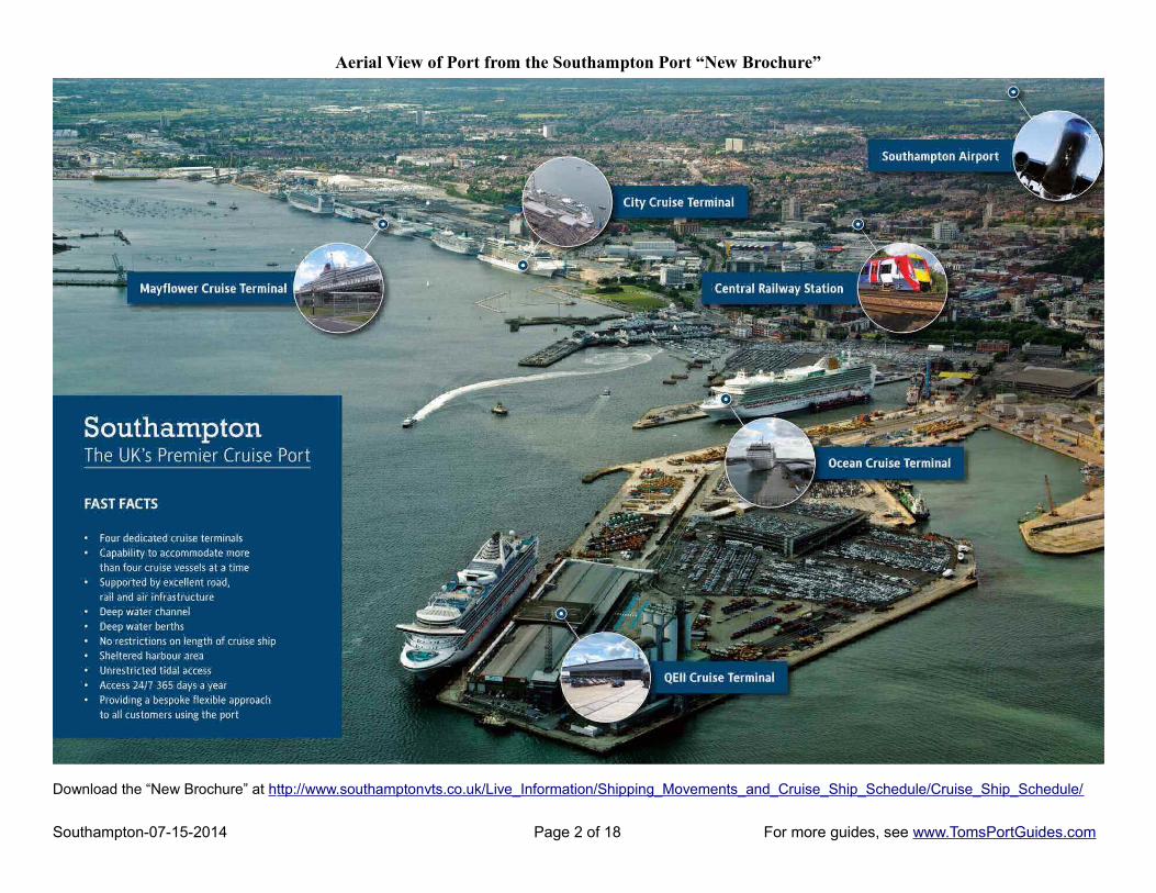
Southampton Cruise Ship Terminals, Berths, and Dock Gate Locations
Download the “official” port maps from http://www.southamptonvts.co.uk/Port_Maps/
I have marked up the port map to highlight the four cruise ship terminals; namely, QEII, Ocean, City, and Mayflower. I have also highlighted dock gate entrances. Dock gate 20 is not shown on this cropped map; it's west of the Mayflower Terminal. Ferry boats have two terminals to load/unload ferries for vehicles and ferries for passengers. The ferry company website is redfunnel.co.uk
Southampton-07-15-2014 Page 3 of 18 For more guides, see www.TomsPortGuides.com
Southampton Port Authority WebsiteI highly recommend visiting the port authority website. You can download the “official” port map plus other excellent information. Download Cruise Ship Schedules and the “New Brochure” from this link http://www.southamptonvts.co.uk/Live_Information/Shipping_Movements_and_Cruise_Ship_Schedule/Cruise_Ship_Schedule/
Cruise Ship Schedule
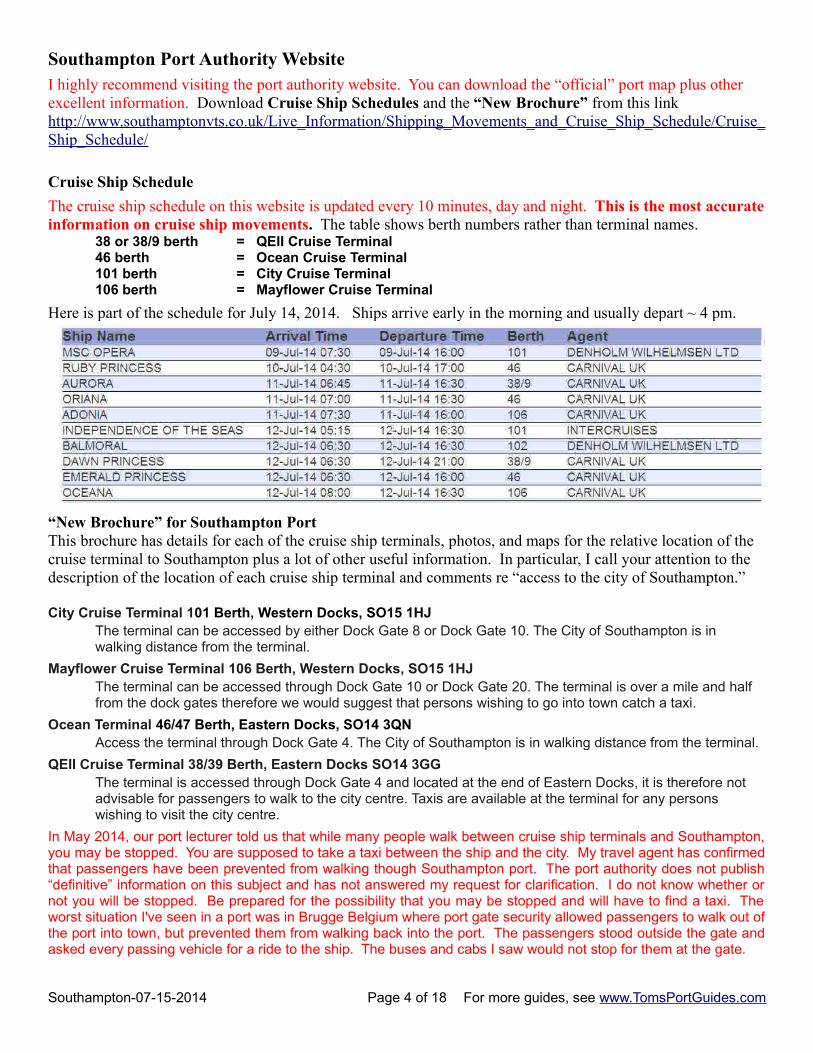
The cruise ship schedule on this website is updated every 10 minutes, day and night. This is the most accurateinformation on cruise ship movements. The table shows berth numbers rather than terminal names.
38 or 38/9 berth = QEII Cruise Terminal46 berth = Ocean Cruise Terminal101 berth = City Cruise Terminal106 berth = Mayflower Cruise Terminal
Here is part of the schedule for July 14, 2014. Ships arrive early in the morning and usually depart ~ 4 pm.
“New Brochure” for Southampton PortThis brochure has details for each of the cruise ship terminals, photos, and maps for the relative location of the cruise terminal to Southampton plus a lot of other useful information. In particular, I call your attention to the description of the location of each cruise ship terminal and comments re “access to the city of Southampton.”
City Cruise Terminal 101 Berth, Western Docks, SO15 1HJ The terminal can be accessed by either Dock Gate 8 or Dock Gate 10. The City of Southampton is in walking distance from the terminal.
Mayflower Cruise Terminal 106 Berth, Western Docks, SO15 1HJ The terminal can be accessed through Dock Gate 10 or Dock Gate 20. The terminal is over a mile and half from the dock gates therefore we would suggest that persons wishing to go into town catch a taxi.
Ocean Terminal 46/47 Berth, Eastern Docks, SO14 3QN Access the terminal through Dock Gate 4. The City of Southampton is in walking distance from the terminal.
QEII Cruise Terminal 38/39 Berth, Eastern Docks SO14 3GG The terminal is accessed through Dock Gate 4 and located at the end of Eastern Docks, it is therefore not advisable for passengers to walk to the city centre. Taxis are available at the terminal for any persons wishing to visit the city centre.
In May 2014, our port lecturer told us that while many people walk between cruise ship terminals and Southampton,you may be stopped. You are supposed to take a taxi between the ship and the city. My travel agent has confirmedthat passengers have been prevented from walking though Southampton port. The port authority does not publish“definitive” information on this subject and has not answered my request for clarification. I do not know whether ornot you will be stopped. Be prepared for the possibility that you may be stopped and will have to find a taxi. Theworst situation I've seen in a port was in Brugge Belgium where port gate security allowed passengers to walk out ofthe port into town, but prevented them from walking back into the port. The passengers stood outside the gate andasked every passing vehicle for a ride to the ship. The buses and cabs I saw would not stop for them at the gate.
Southampton-07-15-2014 Page 4 of 18 For more guides, see www.TomsPortGuides.com
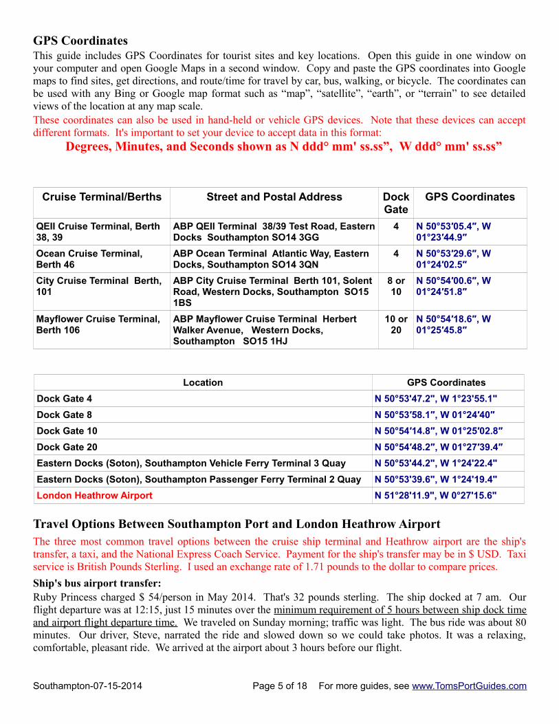
GPS CoordinatesThis guide includes GPS Coordinates for tourist sites and key locations. Open this guide in one window onyour computer and open Google Maps in a second window. Copy and paste the GPS coordinates into Googlemaps to find sites, get directions, and route/time for travel by car, bus, walking, or bicycle. The coordinates canbe used with any Bing or Google map format such as “map”, “satellite”, “earth”, or “terrain” to see detailedviews of the location at any map scale.These coordinates can also be used in hand-held or vehicle GPS devices. Note that these devices can acceptdifferent formats. It's important to set your device to accept data in this format:
Degrees, Minutes, and Seconds shown as N ddd° mm' ss.ss”, W ddd° mm' ss.ss”
Cruise Terminal/Berths Street and Postal Address DockGate
GPS Coordinates
QEII Cruise Terminal, Berth 38, 39
ABP QEII Terminal 38/39 Test Road, EasternDocks Southampton SO14 3GG
4 N 50°53′05.4″, W 01°23′44.9″
Ocean Cruise Terminal, Berth 46
ABP Ocean Terminal Atlantic Way, Eastern Docks, Southampton SO14 3QN
4 N 50°53′29.6″, W 01°24′02.5″
City Cruise Terminal Berth, 101
ABP City Cruise Terminal Berth 101, Solent Road, Western Docks, Southampton SO15 1BS
8 or10
N 50°54′00.6″, W 01°24′51.8″
Mayflower Cruise Terminal, Berth 106
ABP Mayflower Cruise Terminal Herbert Walker Avenue, Western Docks, Southampton SO15 1HJ
10 or20
N 50°54′18.6″, W 01°25′45.8″
Location GPS Coordinates
Dock Gate 4 N 50°53'47.2", W 1°23'55.1"
Dock Gate 8 N 50°53′58.1″, W 01°24′40″
Dock Gate 10 N 50°54′14.8″, W 01°25′02.8″
Dock Gate 20 N 50°54′48.2″, W 01°27′39.4″
Eastern Docks (Soton), Southampton Vehicle Ferry Terminal 3 Quay N 50°53'44.2", W 1°24'22.4"
Eastern Docks (Soton), Southampton Passenger Ferry Terminal 2 Quay N 50°53'39.6", W 1°24'19.4"
London Heathrow Airport N 51°28'11.9", W 0°27'15.6"
Travel Options Between Southampton Port and London Heathrow AirportThe three most common travel options between the cruise ship terminal and Heathrow airport are the ship'stransfer, a taxi, and the National Express Coach Service. Payment for the ship's transfer may be in $ USD. Taxiservice is British Pounds Sterling. I used an exchange rate of 1.71 pounds to the dollar to compare prices.
Ship's bus airport transfer:Ruby Princess charged $ 54/person in May 2014. That's 32 pounds sterling. The ship docked at 7 am. Ourflight departure was at 12:15, just 15 minutes over the minimum requirement of 5 hours between ship dock timeand airport flight departure time. We traveled on Sunday morning; traffic was light. The bus ride was about 80minutes. Our driver, Steve, narrated the ride and slowed down so we could take photos. It was a relaxing,comfortable, pleasant ride. We arrived at the airport about 3 hours before our flight.
Southampton-07-15-2014 Page 5 of 18 For more guides, see www.TomsPortGuides.com
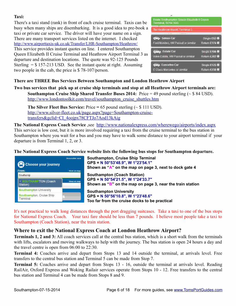
Taxi:There's a taxi stand (rank) in front of each cruise terminal. Taxis can bebusy when many ships are disembarking. It is a good idea to pre-book ataxi or private car service. The driver will have your name on a sign. There are many transport services listed on the internet. I checkedhttp://www.airporttaxis-uk.co.uk/Transfer/LHR-Southampton/Heathrow/This service provides instant quotes on line. I entered SouthamptonQueen Elizabeth II Cruise Terminal and Heathrow Airport Terminal 3 asdeparture and destination locations. The quote was 92-125 PoundsSterling = $ 157-213 USD. See the instant quote at right. Assumingtwo people in the cab, the price is $ 78-107/person.
There are THREE Bus Services Between Southampton and London Heathrow Airport
Two bus services that pick up at cruise ship terminals and stop at all Heathrow Airport terminals are:Southampton Cruise Ship Shared Transfer Buses 2014: Price = 49 pound sterling (~ $ 84 USD). http://www.londontoolkit.com/travel/southampton_cruise_shuttles.htm
The Silver Fleet Bus Service: Price = 65 pound sterling (~ $ 111 USD).http://www.silver-fleet.co.uk/page.aspx?page=Southampton-cruise-transfers&gclid=CI_4oojpx78CFTJo7Aod13kAig
The National Express Coach Service ,see http://www.nationalexpress.com/wherewego/airports/index.aspxThis service is low cost, but it is more involved requiring a taxi from the cruise terminal to the bus station in Southampton where you wait for a bus and you may have to walk some distance to your airport terminal if yourdeparture is from Terminal 1, 2, or 3.
The National Express Coach Service website lists the following bus stops for Southampton departure.
Southampton, Cruise Ship TerminalGPS = N 50°53'48.9", W 1°23'54.1" Shown as “A” on the map on page 3, next to dock gate 4
Southampton (Coach Station) GPS = N 50°54'21.5", W 1°24'33.7" Shown as “B” on the map on page 3, near the train station
Southampton University GPS = N 50°56'10.8", W 1°23'48.6" Too far from the cruise docks to be practical
It's not practical to walk long distances through the port dragging suitcases. Take a taxi to one of the bus stopsfor National Express Coach. Your taxi fare should be less than 7 pounds. I believe most people take a taxi toSouthampton (Coach Station), near the train station.
Where to exit the National Express Coach at London Heathrow Airport? Terminals 1, 2 and 3: All coach services call at the central bus station, which is a short walk from the terminalswith lifts, escalators and moving walkways to help with the journey. The bus station is open 24 hours a day andthe travel centre is open from 06:00 to 22:30.Terminal 4: Coaches arrive and depart from Stops 13 and 14 outside the terminal, at arrivals level. Freetransfers to the central bus station and Terminal 5 can be made from Stop 7.Terminal 5: Coaches arrive and depart from Stops 13 - 16, outside the terminal at arrivals level. ReadingRailAir, Oxford Express and Woking Railair services operate from Stops 10 - 12. Free transfers to the centralbus station and Terminal 4 can be made from Stops 8 and 9.
Southampton-07-15-2014 Page 6 of 18 For more guides, see www.TomsPortGuides.com
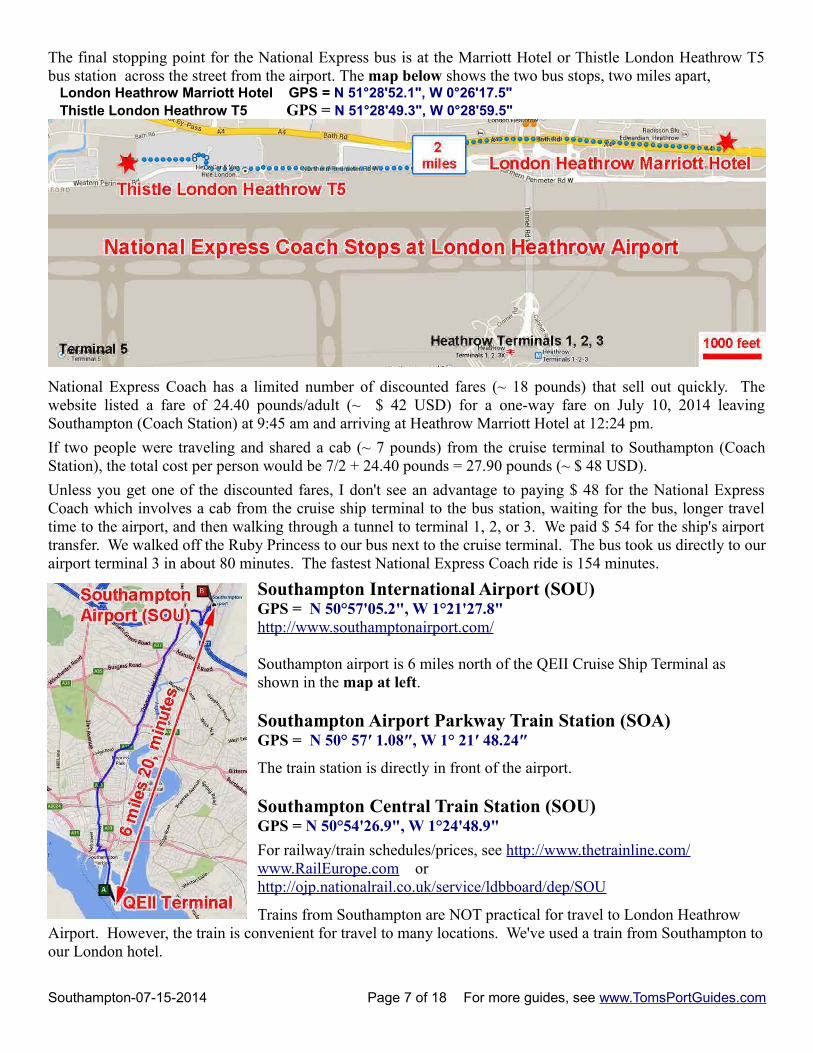
The final stopping point for the National Express bus is at the Marriott Hotel or Thistle London Heathrow T5bus station across the street from the airport. The map below shows the two bus stops, two miles apart, London Heathrow Marriott Hotel GPS = N 51°28'52.1", W 0°26'17.5" Thistle London Heathrow T5 GPS = N 51°28'49.3", W 0°28'59.5"
National Express Coach has a limited number of discounted fares (~ 18 pounds) that sell out quickly. Thewebsite listed a fare of 24.40 pounds/adult (~ $ 42 USD) for a one-way fare on July 10, 2014 leavingSouthampton (Coach Station) at 9:45 am and arriving at Heathrow Marriott Hotel at 12:24 pm.
If two people were traveling and shared a cab (~ 7 pounds) from the cruise terminal to Southampton (CoachStation), the total cost per person would be 7/2 + 24.40 pounds = 27.90 pounds (~ $ 48 USD).
Unless you get one of the discounted fares, I don't see an advantage to paying $ 48 for the National ExpressCoach which involves a cab from the cruise ship terminal to the bus station, waiting for the bus, longer traveltime to the airport, and then walking through a tunnel to terminal 1, 2, or 3. We paid $ 54 for the ship's airporttransfer. We walked off the Ruby Princess to our bus next to the cruise terminal. The bus took us directly to ourairport terminal 3 in about 80 minutes. The fastest National Express Coach ride is 154 minutes.
Southampton International Airport (SOU) GPS = N 50°57'05.2", W 1°21'27.8"http://www.southamptonairport.com/
Southampton airport is 6 miles north of the QEII Cruise Ship Terminal as shown in the map at left.
Southampton Airport Parkway Train Station (SOA) GPS = N 50° 57′ 1.08″, W 1° 21′ 48.24″
The train station is directly in front of the airport.
Southampton Central Train Station (SOU) GPS = N 50°54'26.9", W 1°24'48.9"
For railway/train schedules/prices, see http://www.thetrainline.com/ www.RailEurope.com or http://ojp.nationalrail.co.uk/service/ldbboard/dep/SOU
Trains from Southampton are NOT practical for travel to London Heathrow Airport. However, the train is convenient for travel to many locations. We've used a train from Southampton toour London hotel.
Southampton-07-15-2014 Page 7 of 18 For more guides, see www.TomsPortGuides.com
Car Rental in Southampton Area
We rented a car in Southampton when we disembarked the Emerald Princess to vacation in England for three days. We returned the car to Southampton to board the Queen Mary II for New York. We used taxis between the cruise ship terminal and the car rental agency. I always book my car rental before my cruise.
Use Google to find car rentals using 1) a map search or, 2) a text search of the Internet.
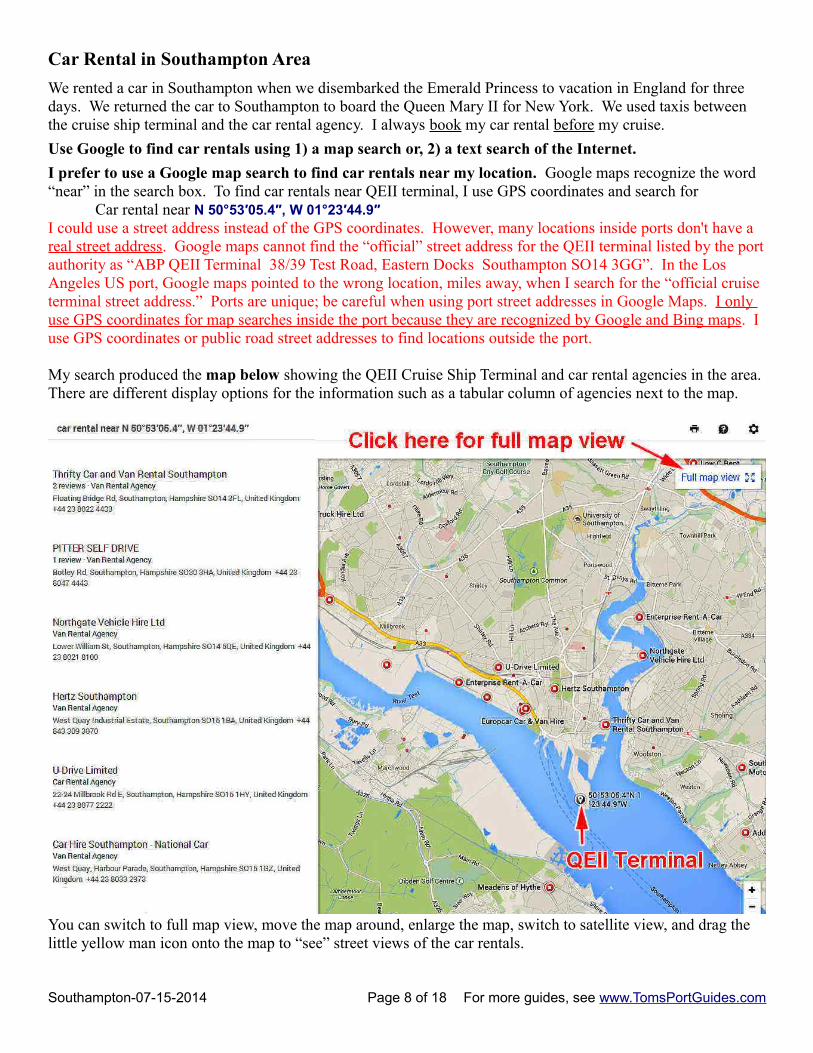
I prefer to use a Google map search to find car rentals near my location. Google maps recognize the word “near” in the search box. To find car rentals near QEII terminal, I use GPS coordinates and search for
Car rental near N 50°53′05.4″, W 01°23′44.9″ I could use a street address instead of the GPS coordinates. However, many locations inside ports don't have a real street address. Google maps cannot find the “official” street address for the QEII terminal listed by the portauthority as “ABP QEII Terminal 38/39 Test Road, Eastern Docks Southampton SO14 3GG”. In the Los Angeles US port, Google maps pointed to the wrong location, miles away, when I search for the “official cruise terminal street address.” Ports are unique; be careful when using port street addresses in Google Maps. I only use GPS coordinates for map searches inside the port because they are recognized by Google and Bing maps. I use GPS coordinates or public road street addresses to find locations outside the port.
My search produced the map below showing the QEII Cruise Ship Terminal and car rental agencies in the area. There are different display options for the information such as a tabular column of agencies next to the map.
You can switch to full map view, move the map around, enlarge the map, switch to satellite view, and drag the little yellow man icon onto the map to “see” street views of the car rentals.
Southampton-07-15-2014 Page 8 of 18 For more guides, see www.TomsPortGuides.com
You can search the web by entering “Southampton England car rental” in the Google search boxGoogle displayed this list:
Thrifty Car and Van Rental Southampton www.thrifty.co.uk Floating Bridge Rd Southampton, United KingdomAvis Car Hire Southampton International Airport www.avis.co.uk Spitfire Loop Southampton, United KingdomEnterprise Rent-A-Car www.enterprise.co.uk 108 Bitterne Rd West Bitterne Manor, Southampton, UKEnterprise Rent-A-Car www.enterprise.co.uk Southampton Airport Southampton, United KingdomNational Car Rental www.nationalcar.com Unit J West Quay Rd, Southampton, United KingdomPitter Self Drive www.pitterselfdrive.co.uk Botley Rd Southampton, United KingdomHertz Rent-A-Car www.hertz.co.uk W Quay Rd City Centre, Southampton, United Kingdom
Below this list, Google displays a link stating “Map results for Southampton England car rental” Click on the link to see the map of the area showing the car rentals. Note this map does NOT show your starting location at the QEII terminal. That's why I prefer the Map search as described on the previous page.
CAUTION: Much of the information on the web is out of date and incorrect
The internet facilitates initial publication of data, but data is rarely updated when changes occur. Car rentalagencies listed by Google may have changed name or moved to a different location. Google, and many of thetravel websites, do not show current, updated, accurate listings. The best, and perhaps only, accurate listing forcar rental locations is the parent company website for that car rental agency. Be sure to verify the actuallocation before you book a car rental.
Rent a car with GPS in England
England is a beautiful country and an excellent place to vacation. However, roads can be confusing, especiallywhen driving through small villages and remote areas. When you pick up the car, press the “where am I button”on the GPS and save that location so you can always find your way back to the rental agency. Program yourdestination with street address or GPS coordinates to easily find you way in spite of detours, roundabouts, andsmall, poorly marked roads in villages and rural area.
Estimating taxi fares in Southampton
You'll need a taxi to the car rental and to many locations around the port. This website is handy. Enter yourdeparture and destination locations and the website calculates travel distance, route, time, and cost.http://www.taxiautofare.com/uk/269/Southampton-Taxi-fare-calculator/loid
NOTE: Street/postal addresses within a port are problematic. Map programs have difficulty finding the cruiseship terminals. In addition, the taxi fare estimator website does not accept GPS coordinates for data input.
I tested the taxi fare website:• It finds and accurately maps fares to/from Mayflower cruise terminal. • The fare and route it shows from City terminal is actually from Mayflower terminal. • The fare/route it shows for Ocean terminal is actually from the bus stop next to Dock Gate 4. That bus
stop is called “Southampton Cruise Ship Terminal”. It's the bus stop used by National Coach Express. Add 0.6 mile to the taxi website travel distance if your ship is at Ocean Cruise Terminal.
• Neither the taxi fare estimating website nor Google maps have any idea where the prestigious QEII Cruise Ship Terminal is located. Use “Ocean Terminal” on the taxi fare website and add 0.9 miles to the travel distance if your ship is at QEII terminal.
Southampton-07-15-2014 Page 9 of 18 For more guides, see www.TomsPortGuides.com
Here's a table showing typical Southampton area taxi fares by travel distance. You can use the GPS informationI provide in this port guide to estimate travel distance from your cruise terminal and approximate the cost for a taxi to your destination using this table based on the distance traveled. Most of the travel distances are short such as the Central Train Station which is less than 2 miles from the cruise terminals.
Approximate Southampton Area Taxi Fares from the Cruise Ship Terminals
Distance (miles) Time (minutes) Cost (Pounds Sterling) Cost converted to $ USD
1 5 5 to 6 9 to 10
2 7 6 to 7 10 to 12
4 13 9 to 11 15 to 19
Things to See and Do in Southampton The Southampton Tourism Website is excellent, see http://www.discoversouthampton.co.uk/
ShoppingWest Quay Shopping Centre GPS = N 50°54′13.5″, W 01°24′23″
List of shops http://www.west-quay.co.uk/shops#Billed as the premier shopping centre on the south coast, West Quay is a 3-level complex with 100 storesoffering top brands, fashion, housewares, and more. Stores include John Lewis, Marks & Spencer and leadingfashion retailers such as French Connection, Coast, Karen Millen, Zara, and River Island.
The Marlands Shopping Centre GPS = N 50°54′21.9″, W 01°24′21.1″List of shops http://www.west-quay.co.uk/shops#
The centre has over 40 high street stores, cafes, specialist boutiques, and the Disney Store.
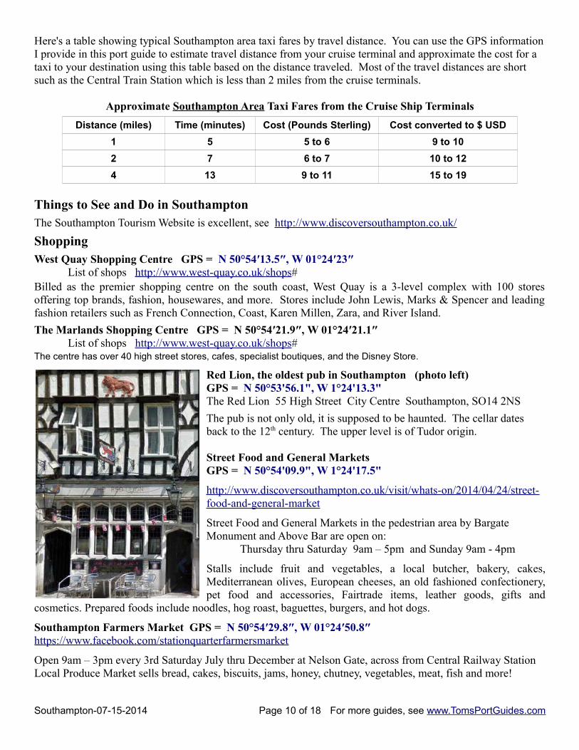
Red Lion, the oldest pub in Southampton (photo left)GPS = N 50°53'56.1", W 1°24'13.3" The Red Lion 55 High Street City Centre Southampton, SO14 2NS
The pub is not only old, it is supposed to be haunted. The cellar dates back to the 12th century. The upper level is of Tudor origin.
Street Food and General Markets GPS = N 50°54'09.9", W 1°24'17.5"
http://www.discoversouthampton.co.uk/visit/whats-on/2014/04/24/street-food-and-general-market
Street Food and General Markets in the pedestrian area by Bargate Monument and Above Bar are open on:
Thursday thru Saturday 9am – 5pm and Sunday 9am - 4pm
Stalls include fruit and vegetables, a local butcher, bakery, cakes,Mediterranean olives, European cheeses, an old fashioned confectionery,pet food and accessories, Fairtrade items, leather goods, gifts and
cosmetics. Prepared foods include noodles, hog roast, baguettes, burgers, and hot dogs.
Southampton Farmers Market GPS = N 50°54′29.8″, W 01°24′50.8″https://www.facebook.com/stationquarterfarmersmarket
Open 9am – 3pm every 3rd Saturday July thru December at Nelson Gate, across from Central Railway StationLocal Produce Market sells bread, cakes, biscuits, jams, honey, chutney, vegetables, meat, fish and more!
Southampton-07-15-2014 Page 10 of 18 For more guides, see www.TomsPortGuides.com
Tudor House and Garden GPS = N 50°53'58.5", W 1°24'21.7"www.tudorhouseandgarden.com/ Southampton’s most important historic building, Tudor House reveals over 800 years of history in one fascinating location at the heart of the Old Town. The timber-framed building facing St Michael’s Square was built in the late 15th Century, with King John’s Palace, an adjacent Norman house accessible from Tudor House Garden, dating back a further 300 years.
Open every day except 24th December – 1st January Tuesday to Friday 10am-3pm, Saturday to Sunday
10am-5pm, Closed Mondays (except Bank Holidays 10am-5pm) Adult admission 4.75 pounds sterling
Museums, Art, & MonumentsSouthampton City Art Gallery GPS = N 50°54'30.4", W 1°24'22.8"http://www.southampton.gov.uk/s-leisure/artsheritage/sotonartgallery/
The gallery is internationally renowned for its permanent collection, spanning eight centuries, which tell the story of western art from the Renaissance to the present day. The core of the collection is twentieth century and contemporary British art. . Also, the gallery offers high quality exhibitions ranging from painting, sculpture and drawing, to photography and film, as well as displays that change regularly to ensure new experiences with eachvisit.
Open: Monday - Friday 10am - 3pm and Saturday 10am - 5pm Closed: Sundays Admission: Free
Maritime Museum The Maritime Museum is closed. Artifacts have been moved to Sea City Museum.
SeaCity Museum GPS = N 50°54'29.1", W 1°24'26.5"SeaCity Museum, Havelock Road, Southampton, Hampshire, SO14 7FY http://www.seacitymuseum.co.uk/
The museum tells the story of the people of the city, their fascinating lives and historic connections with Titanicand the sea. Allow two to three hours to explore the museum.
Open 7 days a week 10am – 5pm Last admission 4pm Adult admission = 8.50 pounds sterling
Mayflower Theatre GPS = N 50°54'31.9", W 1°24'36.9"https://www.mayflower.org.uk/For maps and directions, see https://www.mayflower.org.uk/map.asp
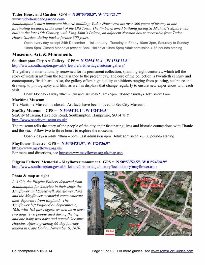
Pilgrim Fathers' Memorial - Mayflower monument GPS = N 50°53′52.5″, W 01°24′24.9″http://www.southampton.gov.uk/s-leisure/artsheritage/history/localhistory/mayflower.aspx
Photo & map at right
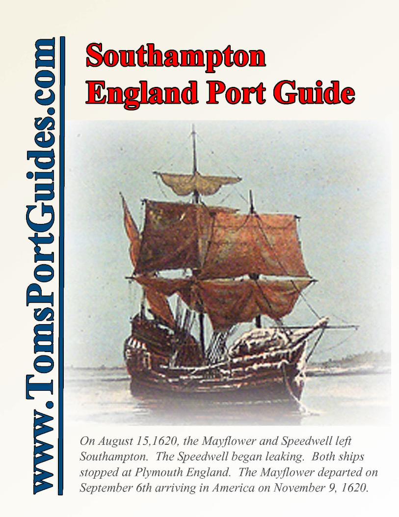
In 1620, the Pilgrim Fathers departed fromSouthampton for America in their ships theMayflower and Speedwell. Mayflower Parkand the Mayflower memorial commemoratetheir departure from England. TheMayflower left England on September 6,1620 with 102 passengers, as well as at leasttwo dogs. Two people died during the tripand one baby was born and named OceanusHopkins. After a grueling 66-day journeylanded in Cape Cod on November 9, 1620.
Southampton-07-15-2014 Page 11 of 18 For more guides, see www.TomsPortGuides.com
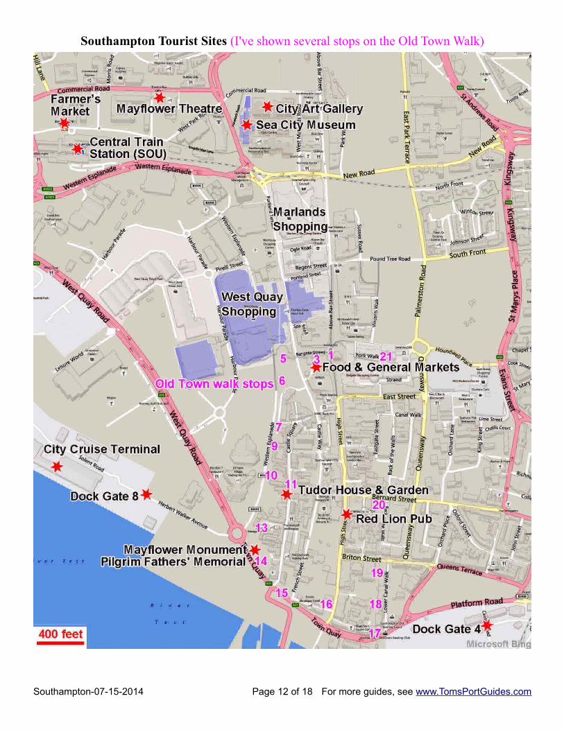
Southampton Tourist Sites (I've shown several stops on the Old Town Walk)
Southampton-07-15-2014 Page 12 of 18 For more guides, see www.TomsPortGuides.com
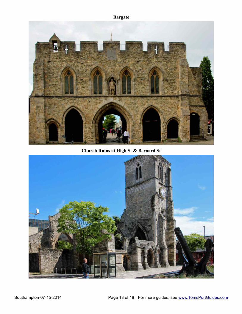
Bargate
Church Ruins at High St & Bernard St
Southampton-07-15-2014 Page 13 of 18 For more guides, see www.TomsPortGuides.com
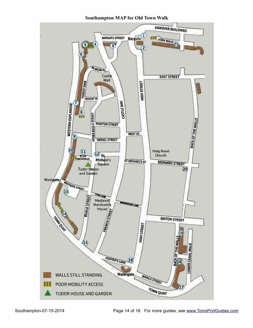
Southampton MAP for Old Town Walk
Southampton-07-15-2014 Page 14 of 18 For more guides, see www.TomsPortGuides.com
Southampton Old Town WalkSouthampton has some of England’s best-preserved medieval Town Walls. The walk is 1.25 miles. Note thatsome sections of the wall have poor mobility access.
Download the map and brochure for the Old Town Walk from http://www.discoversouthampton.co.uk/uploads/media_items/old-town-walk-map.original.pdf
A series of panels guides you around the encircling walls to reveal the events and people who have shaped our city, from the medieval merchant John Wytegod to WFG Spranger, the nineteenth century saviour of Tudor House. We recommend you start the Walk at the Bargate, the historic entrance to the medieval town, but you can begin at any point.
I have shown some of the stops on the Old Town Walk on the Microsoft Bing map on page 12
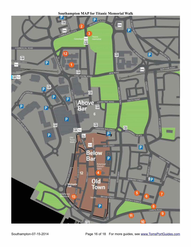
Southampton Titanic Memorial WalkDownload the map at http://www.seacitymuseum.co.uk/wp-content/uploads/Titanic-Trail-MAY.pdf
Loss of the Titanic had a profound effect on Southampton touching the lives of residents. In memory of those lost at sea, the residents built many memorials and placed them throughout the city. The memorial walk map points out locations of these memorials and the story behind each memorial.
1. Titanic Postal Workers ’ MemorialThis commemorates two British Sea Post officers and three American colleagues. The plaque is made from a spare propeller. It's on the first floor of the Civic Centre, to the right of the Council Chamber doors. The Titanic Book of Remembrance of victims of the Titanic, can also be seen at this location, displayed on a marble plinth.
2. Titanic Musicians’ MemorialThis is a replica of the original memorial. It depicts a grieving woman and Titanic sinking, with a musical inscription of the first few bars of ‘Nearer, my God to thee’. The memorial is in Cumberland Place, near London Road.
3. Engineer Officers’ MemorialConstructed of Aberdeen granite and surmounted by a seven foot high angel, the memorial commemorates the engineer officers on the Titanic all of whom died. Located in East Park, Southampton, fronting the main road.
4 Titanic Crew MemorialThis memorial was made from Portland Stone by local stonemasons Garret & Haysom. It's at Holy Rood Church.
5. Former Sailors’ HomeThis building was a sailors’ home in 1909 to provide temporary accommodation for seamen whilst they were in port. Several of the Titanic crew stayed here prior to sailing. Located in Oxford Street, now a Salvation Army centre.
6. The Grapes Public HouseThis pub, which dates back to the 1850s, was a favorite for seafarers, and some members of Titanic’s crew (including the three Slade brothers) famously stayed here too long on the morning of departure. They arrived at the dockside just as the ship was about to depart and were refused entry to the Titanic. The pub is on Oxford Street.
7. Terminus Rail way Station In 1912, this was the railway station nearest to the docks.The main station building built 1839/40, is now a casino. At the back of the building is a covered area, where the platforms of the station used to be. Located in Terminus Terrace, opposite the entrance to Oxford Street.
8. South Western HouseIn 1912 this building was the first class hotel where some of Titanic’s wealthier passengers spent their last night before the voyage. These included Thomas Andrews and J Bruce Ismay (President of the White Star Line).Now converted into flats, the building can be seen on the corner of Canute Road and Terminus Terrace.
Southampton-07-15-2014 Page 15 of 18 For more guides, see www.TomsPortGuides.com
1 Bargate3 Town Walls5 Arundel Tower6 Forty Steps7 Castle Vault 9 Simnel St
10 The Arcades 11 Blue Anchor Lane 13 Westgare 14 Cuckoo Lane 15 Town Quay 16 Watergate
17 God's House Tower 18 Friary Gate 19 Town Ditch 20 Back of the Walls 21 York Gate
Southampton MAP for Titanic Memorial Walk
Southampton-07-15-2014 Page 16 of 18 For more guides, see www.TomsPortGuides.com
9. Canute ChambersIn 1912 this building was the Southampton headquarters of the White Star Line. A memorial plaque marks the spot where anxious relatives came to await news of their loved-ones after Titanic was lost. When the names of survivors were telegraphed to the offices, they were posted up on boards fixed to the railings.Located on the south side of Canute Road. There is no public access to the inside of Canute Chambers
10. Ocean Dock and Dock Gate 4 memorial Titanic departed from Ocean Dock (then called White Star Dock) on 10th April 1912. A small plaque, located just inside the security gate for Dock Gate 4, commemorates those who died in the disaster
11. Former Dock’s Branch Post OfficeBuilt at the turn of the 20th century, this building (now converted into flats) housed the Docks’ Post Office and Telegraph Office. It was here that Titanic’s mail was sorted before being loaded on to the ship.Located on the south side of Platform Road. There is no access to the building
12. SEACITY MUSEUMSeaCity Museum tells the story of the people of Southampton, their fascinating lives and the city’s historic connection with the sea. Visit us to discover how we bring maritime history to life through an interactive experience designed for all ages.
13. Gatti MemorialAn oak table, which has a plaque in memory of the restaurant workers who lost their lives (including ‘Luigi’ Gatti, who was responsible for the restaurants on board the ship). The memorial can be found inside St Joseph’s Church, Bugle Street. Please note that the church may not be open at all times
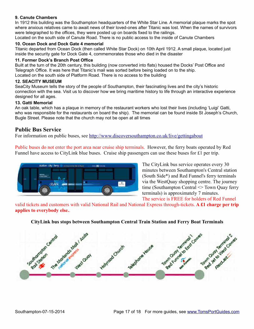
Public Bus ServiceFor information on public buses, see http://www.discoversouthampton.co.uk/live/gettingabout
Public buses do not enter the port area near cruise ship terminals. However, the ferry boats operated by Red Funnel have access to CityLink blue buses. Cruise ship passengers can use these buses for £1 per trip.
The CityLink bus service operates every 30 minutes between Southampton's Central station (South Side*) and Red Funnel's ferry terminals via the WestQuay shopping centre. The journey time (Southampton Central <> Town Quay ferryterminals) is approximately 7 minutes. The service is FREE for holders of Red Funnel
valid tickets and customers with valid National Rail and National Express through-tickets. A £1 charge per tripapplies to everybody else..
CityLink bus stops between Southampton Central Train Station and Ferry Boat Terminals
Southampton-07-15-2014 Page 17 of 18 For more guides, see www.TomsPortGuides.com
User Feedback Is Welcome GoalMy guides are designed to help you plan a great cruise vacation by providing information such as where the ship docks, location of tourist sites, public transit, walking tour maps, things to see and do, travel issues unique to the port, etc. Knowledge of ports is important when planning shore excursions because you have to make many decisions and commitments long before your ship docks. I believe the information in this guide is accurate, however you are responsible to verify accuracy of the information that you use to plan your vacation.
Information on cruise ports frequently changes such as bus routes, admission fees to sites, rental car locations, etc. Cruise Critic is the best source for up-to-date, detailed information on travel details for shore excursions, reviews of cruise ships, etc. There are many knowledgeable people on Cruise Critic who are willing to share their expertise and travel experience. I highly recommend www.CruiseCritic.com; it's free to join.
Why feedback is importantUser feedback helps me make corrections and improve the format and content in my quest to produce the“ultimate” port guides. I welcome offers to collaborate with me or provide materials for use in my guides.
PLEASE Help “spread the word” about my websiteThe only negative feedback I get is, “I wish I knew about your port guides before my vacation”. Please tellyour friends and post a reference to my guides and website on the blogs. To receive email notification whennew guides are available, send your email address to me at [email protected]
Copyright Notice & Terms and Conditions for Use of My Guides
My port guides and everything on my website www.TomsPortGuides.com is copyrighted by Thomas Sheridanwith all rights reserved, and protected by international copyright laws.
PERMITTED USE: Personal, non-commercial use of my port guides and/or material from my website.
I allow individuals to take my guides apart for personal, non-commercial use. Many cruisers carry a map or afew pages from my guide on a shore excursion. That's OK. I also allow people to post my guides on websitesthey set up for fellow travelers to share information on shore excursions such as the websites set up by CruiseCritic members for the Roll Calls. That's OK. My guides are for use and enjoyment of individual travelers.
PROHIBITED USE of my port guides and/or material from my website.NO person, company, organization, website, etc. is permitted to use material from my website for a commercialpurpose, to sell, require a membership to download my port guides, or use my copyrighted material for acommercial purpose.
NO person, company, organization, website, etc. is permitted to distribute excerpts from my guides or materialfrom my website as electronic, digital, or paper copies. My Port Guides must be kept intact, as downloadedfrom my website, with this copyright notice.
NO Cruise Ship employee, representative, contractor, port lecturer, etc. is permitted to distribute excerpts frommy guides or material from my website as electronic, digital or paper copies. My Port Guides must be keptintact, as downloaded from my website, with this copyright notice. A blatant example of violation of mycopyright was a cruise ship docked in Copenhagen where the shore excursion desk personnel removed mapsfrom my guide, removed my name as the copyright owner, and copied/distributed my maps.
Fortunately, a friend of mine on that ship complained to the purser and the ship stopped violating my copyright.
If there is any question about use of my guides, contact me at [email protected]
Tom Sheridan
Southampton-07-15-2014 Page 18 of 18 For more guides, see www.TomsPortGuides.com