title | nature of report port macquarie- hastings council · port macquarie hastings council’s...
TRANSCRIPT
Title | Nature of Report
Setting New Standards
DRAFT REPORT Date month year
MacroPlan Australia
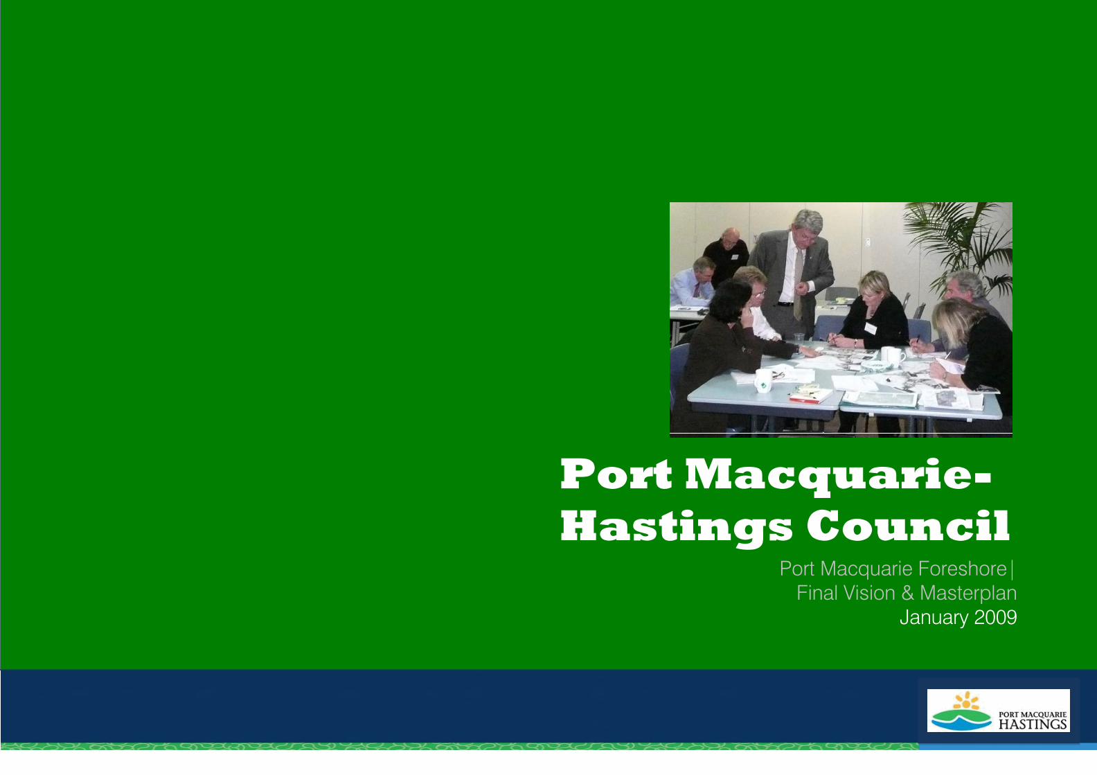
Port Macquarie-Hastings Council
Port Macquarie Foreshore|Final Vision & Masterplan
January 2009
Disclaimer
PROJECT DIRECTOR Steve Finlay (Port Macquarie Hastings Council)
Contact Information
MACROPLAN SYDNEY Suite 1002, Level 10 45 Clarence Street t. 02 9299 8988 f. 02 9241 6002 e. [email protected] w. www.macroplan.com.au GMU Suite 1/5 Wongala Crescent Beecroft NSW 2119 t. 02 9980 2700 f. 9980 2744 e. [email protected]
+ This document has been reviewed by the Director NSW, MacroPlan Australia. This document is for discussion purposes only unless signed and dated by the person(s) identified.
Signed+
…………………………………….……. Dated
+
REPORT CONTACT MacroPlan: Jenny Rudolph [National Planning Manager] GMU: Gabrielle Morrish (Director GMU) Ben Nacard [Senior Urban Designer]
Disclaimer
© MacroPlan Australia Pty Ltd All Rights Reserved. No part of this document may be reproduced, transmitted, stored in a retrieval system, or translated into any language in any form by any means without the written permission of MacroPlan Australia Pty Ltd. Intellectual Property Rights All Rights Reserved. All methods, processes, commercial proposals and other contents described in this document are the confidential intellectual property of MacroPlan Australia Pty Ltd and may not be used or disclosed to any party without the written permission of MacroPlan Australia Pty Ltd.
MacroPlan Australia and GMU would like to thank the Administrator, Steve Finlay, Gai Lazarides, Matt Rogers, Liam Bully, Peter Cameron and all other council staff for their assistance and input in the project.
Prepared for Port Macquarie Hastings Council – January 2009 Page 1 of 49
Contents
1 Introduction ------------------------------------------------------------------------------------------------2
2 Study Area -------------------------------------------------------------------------------------------------3
3 Objective of the Project----------------------------------------------------------------------------------4
4 Consultation Process ------------------------------------------------------------------------------------5
5 Analysis-----------------------------------------------------------------------------------------------------6
6 Summary of Key Issues ------------------------------------------------------------------------------- 30
7 Vision------------------------------------------------------------------------------------------------------ 31
8 Proposed Masterplan Concepts--------------------------------------------------------------------- 34
9 Conclusion ----------------------------------------------------------------------------------------------- 45
+
Prepared for Port Macquarie Hastings Council – January 2009 Page 2 of 49
1 Introduction
MacroPlan Australia, in association with GM Urban Design and Architecture (GMU) have been commissioned by Port Macquarie Hastings Council to undertake extensive consultation with the community to obtain their input into the development of a vision which will assist in the development of a Masterplan for the foreshore of Port Macquarie.
Port Macquarie Hastings Council’s objective of this project is that the vision and Masterplan for the Port Macquarie Foreshore will facilitate increased tourism visitations, community enjoyment, and active use of the area, while simultaneously obtaining good environmental and water quality outcomes. In order to achieve this, two workshops and a Summit was held in order to understand the key issues, opportunities and future vision of the Port Macquarie Foreshore.
Port Macquarie Hastings Council, as well as the project team, acknowledges that a significant amount of work and studies relating to the Port Macquarie Foreshore, and adjacent lands, has been undertaken. The Port Macquarie Foreshore project therefore incorporated the good work and positive elements undertaken in these projects. However, over and above these previous studies, MacroPlan and GMU incorporate the input and comments received during the consultation process for this project to develop a vision, and design options. The draft Port Macquarie Foreshore Plan was exhibited for six weeks and following assessment of the comments received the Foreshore Masterplan was amended. This report outlines the final draft Port Macquarie Foreshore Plan 2008.
MacroPlan and GMU realise, that the vision and objectives for the Port Macquarie Foreshore will only be implemented if the proposed Foreshore Masterplan is practical, sustainable, realistic and feasible, and is held with high pride for the town of Port Macquarie.
This report outlines the proposed vision, character statements, and the Final Port Macquarie Foreshore Plan. The Final Foreshore Masterplan is as a result of the two workshops held on 13th June 2008, the Port Macquarie Foreshore Summit held on 19 June 2008, a further focus group workshop on 31 July 2008, a community open day held on 27th September and the public exhibition period from 27th September to 7th November 2008, and a further exhibition period for two weeks form 28th November 2008. The Final Port Macquarie Foreshore Masterplan is outlined in this report, and has made the necessary amendments as resolved by Council on 17th December 2008. The Masterplan will then be used as a framework for any discussions with the Department of Lands and their plan of management process.
Prepared for Port Macquarie Hastings Council – January 2009 Page 3 of 49
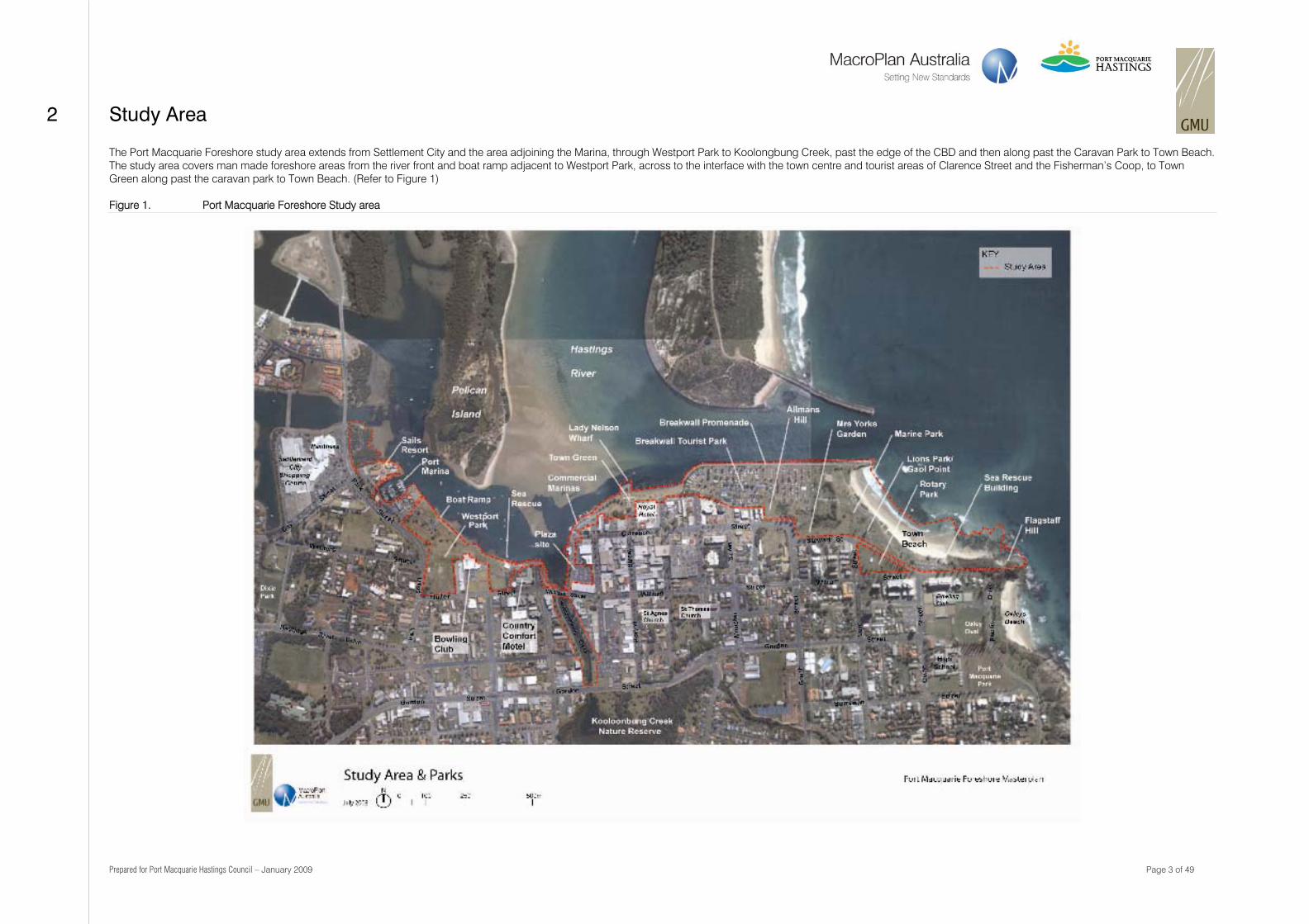
2 Study Area
The Port Macquarie Foreshore study area extends from Settlement City and the area adjoining the Marina, through Westport Park to Koolongbung Creek, past the edge of the CBD and then along past the Caravan Park to Town Beach. The study area covers man made foreshore areas from the river front and boat ramp adjacent to Westport Park, across to the interface with the town centre and tourist areas of Clarence Street and the Fisherman’s Coop, to Town Green along past the caravan park to Town Beach. (Refer to Figure 1)
Figure 1. Port Macquarie Foreshore Study area
Prepared for Port Macquarie Hastings Council – January 2009 Page 4 of 49
3 Objective of the Project
The objectives of the Port Macquarie Foreshore project are to:-
“Create a shared vision for the foreshore development
To develop a Masterplan that makes the foreshore an attractive place that will increase frequency of tourist visitations and enjoyment by the community
Ensure that the outcome for the foreshore has taken into account the community views and input, and thereby providing community support for council to implement the vision
Develop a Masterplan for the foreshore that addresses the need to retain and use public open spaces, critical pedestrian and cycle links, access to the foreshore by the public, but at the same time balance the land use integration and the key visual corridors.
To understand the impact of climate change aspects on the Masterplan and adaptation options”.
Prepared for Port Macquarie Hastings Council – January 2009 Page 5 of 49
4 Consultation Process
The Port Macquarie Foreshore is a significant asset for the regional centre. Council recognised that the future planning of the foreshore should involve the significant land owner (Department of Lands), Council, and community and business groups in Port Macquarie. A key component in compiling the vision and the Masterplan for Port Macquarie foreshore was to involve and consult with the community and business groups. The consultation process was undertaken by involving community, recreational, landowners and business groups in workshops, which culminated in a Summit so to be able to coordinate all inputs/comments.
Port Macquarie Hastings Council organised two workshops, both which were held on 13 June 2008. The objective of the workshops was:-
To identify the key issues, opportunities and constraints;
Identify key priorities; and
An opportunity for the stakeholders to provide principles towards developing a vision for the foreshore.
The first workshop on 13th June was attended by 29 representatives from the business and landowner community, and the second workshop was attended by 34 representatives from the recreational and community groups. Representatives were chosen from each of the working groups at the said two workshops to present their groups outcomes at the Summit held on 19th June 2008.
Port Macquarie Hastings Council organised a Summit that was held on 19th June 2008. The Summit was attended by 83 representatives from the community, recreational groups, business groups, residents, schools, local and state government, including the state member of parliament. The objective of the Summit was to:-
To identify and confirm opportunities and issues along the foreshore study area as initiated at workshops;
Identify and agree on common and important opportunities and issues relating to the Foreshore;
To develop a shared vision for the study area as a whole, and vision for the precincts within the overall area, and
To work together cooperatively to achieve a high quality outcome for the Port Macquarie Foreshore.
The agenda for the Summit included:-
Confirming the project study area;
Presentation by representatives of the workshop groups of the key issues, opportunities and vision ideas;
Presentation/overview of various studies and work undertaken over the foreshore area in the last two to three years;
Agreement of the common issues and opportunities;
Further discussion by the Summit groups on the issues that had not achieved consensus at the workshops, and
Discussion of three potential visions for the Foreshore, to determine which one is more suitable for the future
As a result of all the community input and comments, MacroPlan and GMU assessed each of the inputs and developed a revised vision/s as well as potential design options. Council organised a smaller focus group workshop on 31 July 2008, with attendance by 30 representatives of key groups, to provide comment and input on the revised vision idea, and potential design options for the Foreshore.
The objective of workshop held on 31 July 2008 was to:-
Confirm the Issues and analysis as a result of all the input and comments at the Summit;
Confirm the revised vision and Precinct visions;
Obtain comments/input into the three design concepts for the three precincts of the foreshore; and
Discuss and test the three concepts designs and provide feedback/input.
Comment and discussions at the third focus group workshop resulted in Council, the participants, and the project consulting team realising that producing three design options for the three precincts will be complex to comprehend. The participants at the workshop indicated that it would be more user friendly to have one design concept with potential alternatives at certain locations based on input at the Summit. The one concept design would be based on input provided by the participants at the workshop, and alternative options/designs at certain nodal areas.
The concept plan and options were publically exhibited from 27th September to 7th November 2008 in order to obtain comments and feedback from Port Macquarie residents and businesses. Over 1 500 letters and comments were received by Port Macquarie Hastings Council and have all been read and assessed. The Council made amendments to the Plan at its meeting on 26th November 2008, and re-exhibited the plan for a further two weeks. Fifty two (52) submissions were received during the exhibition period, and after assessment of the comments, the Council on 17 December 2008 made final changes to the Port Macquarie Foreshore Masterplan.
Prepared for Port Macquarie Hastings Council – January 2009 Page 6 of 49
5 Analysis
An analysis of the Foreshore study area was undertaken in order to inform the community consultation process, but also to assist in developing a vision and design concepts for the Foreshore.
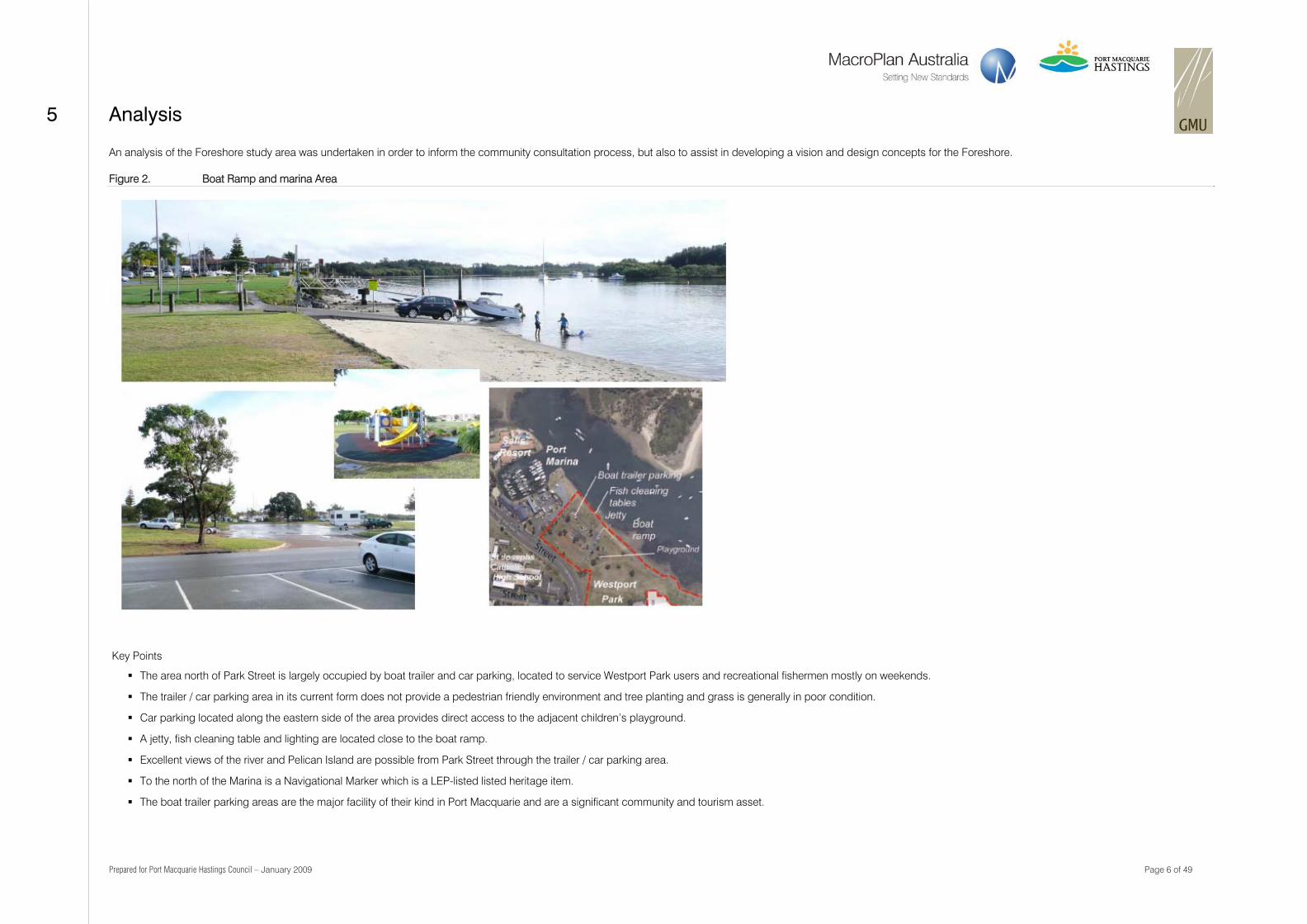
Figure 2. Boat Ramp and marina Area
Key Points
The area north of Park Street is largely occupied by boat trailer and car parking, located to service Westport Park users and recreational fishermen mostly on weekends.
The trailer / car parking area in its current form does not provide a pedestrian friendly environment and tree planting and grass is generally in poor condition.
Car parking located along the eastern side of the area provides direct access to the adjacent children’s playground.
A jetty, fish cleaning table and lighting are located close to the boat ramp.
Excellent views of the river and Pelican Island are possible from Park Street through the trailer / car parking area.
To the north of the Marina is a Navigational Marker which is a LEP-listed listed heritage item.
The boat trailer parking areas are the major facility of their kind in Port Macquarie and are a significant community and tourism asset.
Prepared for Port Macquarie Hastings Council – January 2009 Page 7 of 49
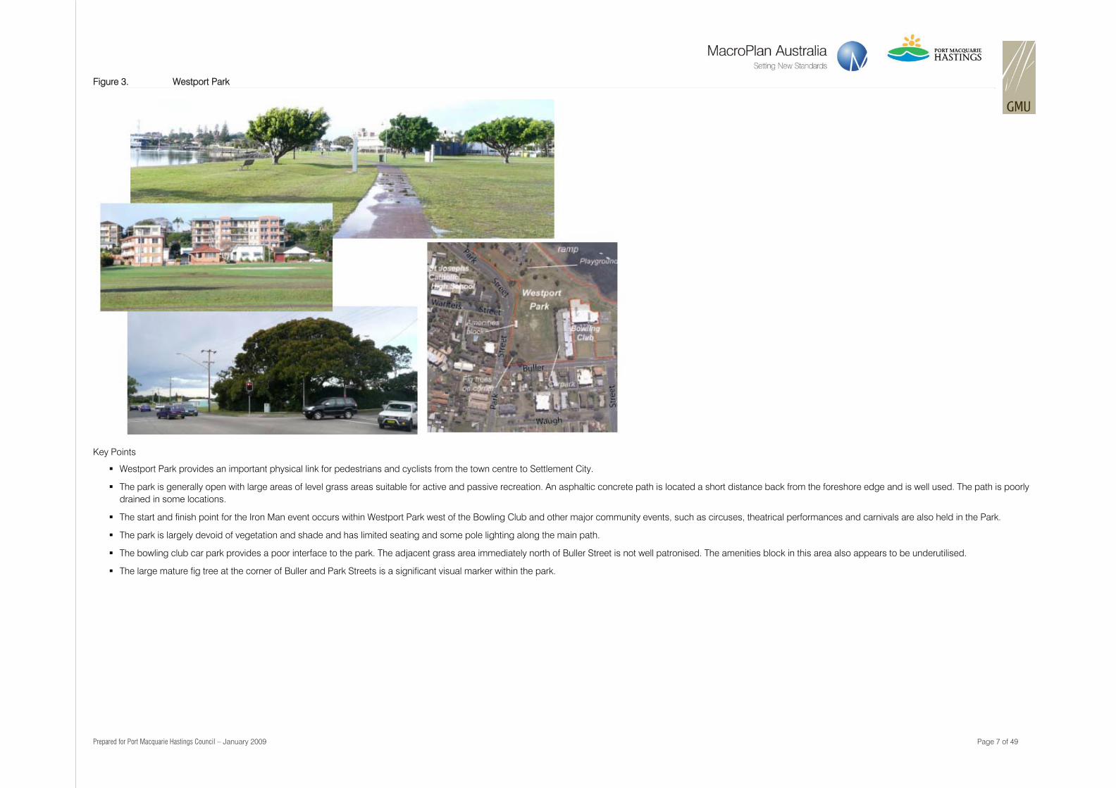
Figure 3. Westport Park
Key Points
Westport Park provides an important physical link for pedestrians and cyclists from the town centre to Settlement City.
The park is generally open with large areas of level grass areas suitable for active and passive recreation. An asphaltic concrete path is located a short distance back from the foreshore edge and is well used. The path is poorly drained in some locations.
The start and finish point for the Iron Man event occurs within Westport Park west of the Bowling Club and other major community events, such as circuses, theatrical performances and carnivals are also held in the Park.
The park is largely devoid of vegetation and shade and has limited seating and some pole lighting along the main path.
The bowling club car park provides a poor interface to the park. The adjacent grass area immediately north of Buller Street is not well patronised. The amenities block in this area also appears to be underutilised.
The large mature fig tree at the corner of Buller and Park Streets is a significant visual marker within the park.
Prepared for Port Macquarie Hastings Council – January 2009 Page 8 of 49
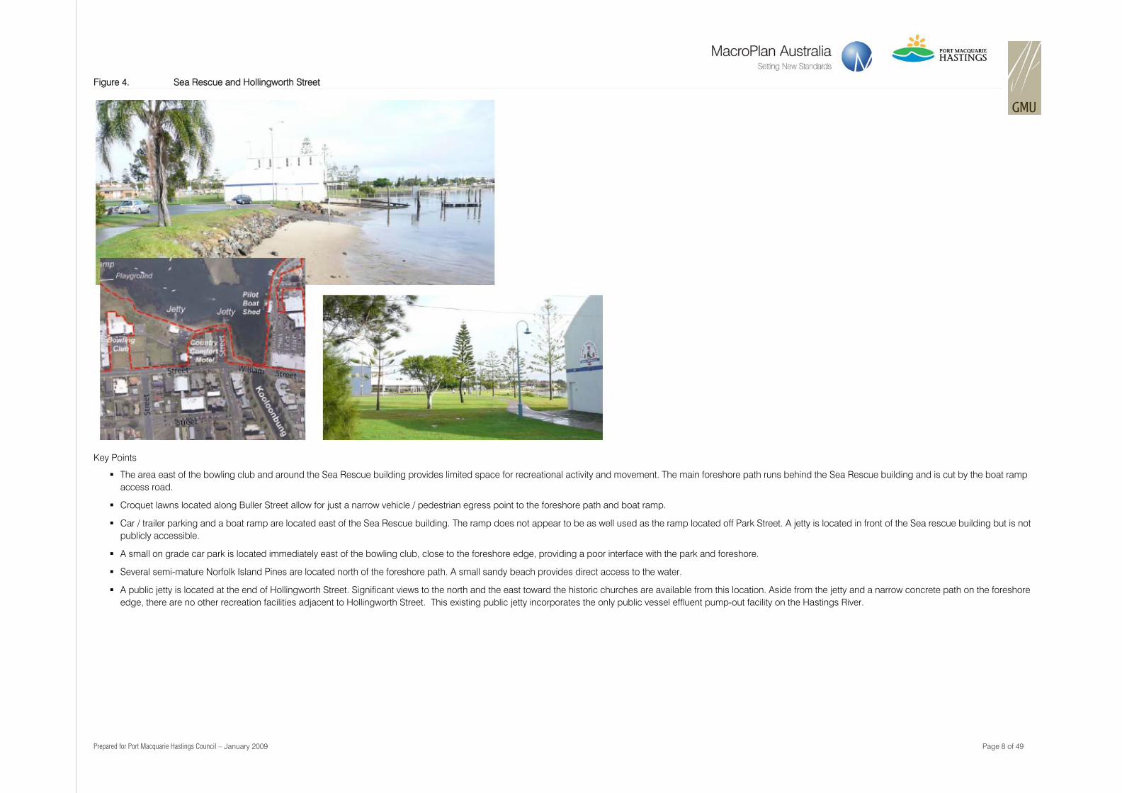
Figure 4. Sea Rescue and Hollingworth Street
Key Points
The area east of the bowling club and around the Sea Rescue building provides limited space for recreational activity and movement. The main foreshore path runs behind the Sea Rescue building and is cut by the boat ramp access road.
Croquet lawns located along Buller Street allow for just a narrow vehicle / pedestrian egress point to the foreshore path and boat ramp.
Car / trailer parking and a boat ramp are located east of the Sea Rescue building. The ramp does not appear to be as well used as the ramp located off Park Street. A jetty is located in front of the Sea rescue building but is not publicly accessible.
A small on grade car park is located immediately east of the bowling club, close to the foreshore edge, providing a poor interface with the park and foreshore.
Several semi-mature Norfolk Island Pines are located north of the foreshore path. A small sandy beach provides direct access to the water.
A public jetty is located at the end of Hollingworth Street. Significant views to the north and the east toward the historic churches are available from this location. Aside from the jetty and a narrow concrete path on the foreshore edge, there are no other recreation facilities adjacent to Hollingworth Street. This existing public jetty incorporates the only public vessel effluent pump-out facility on the Hastings River.
Prepared for Port Macquarie Hastings Council – January 2009 Page 9 of 49
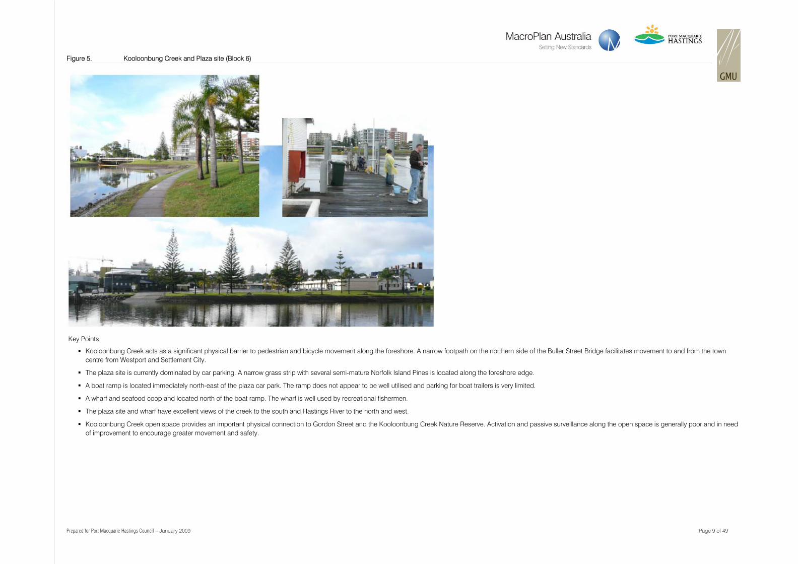
Figure 5. Kooloonbung Creek and Plaza site (Block 6)
Key Points
Kooloonbung Creek acts as a significant physical barrier to pedestrian and bicycle movement along the foreshore. A narrow footpath on the northern side of the Buller Street Bridge facilitates movement to and from the town centre from Westport and Settlement City.
The plaza site is currently dominated by car parking. A narrow grass strip with several semi-mature Norfolk Island Pines is located along the foreshore edge.
A boat ramp is located immediately north-east of the plaza car park. The ramp does not appear to be well utilised and parking for boat trailers is very limited.
A wharf and seafood coop and located north of the boat ramp. The wharf is well used by recreational fishermen.
The plaza site and wharf have excellent views of the creek to the south and Hastings River to the north and west.
Kooloonbung Creek open space provides an important physical connection to Gordon Street and the Kooloonbung Creek Nature Reserve. Activation and passive surveillance along the open space is generally poor and in need of improvement to encourage greater movement and safety.
Prepared for Port Macquarie Hastings Council – January 2009 Page 10 of 49
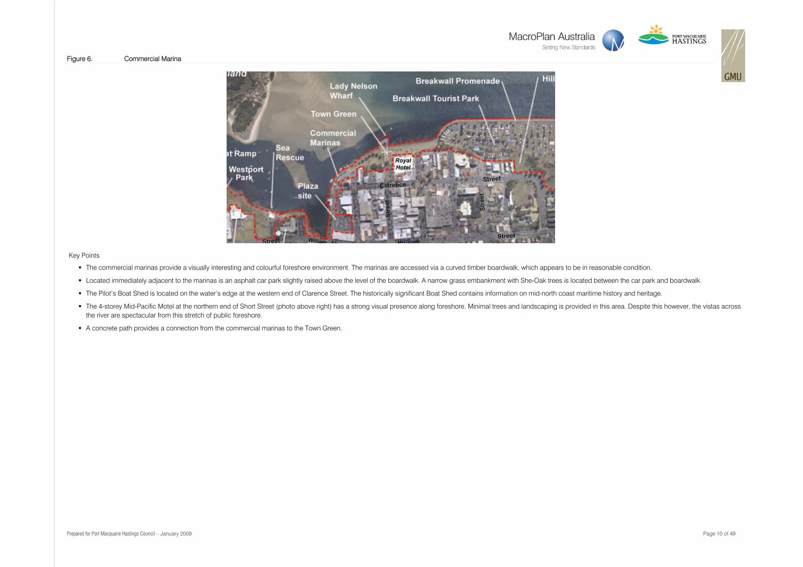
Figure 6. Commercial Marina
Key Points
The commercial marinas provide a visually interesting and colourful foreshore environment. The marinas are accessed via a curved timber boardwalk, which appears to be in reasonable condition.
Located immediately adjacent to the marinas is an asphalt car park slightly raised above the level of the boardwalk. A narrow grass embankment with She-Oak trees is located between the car park and boardwalk.
The Pilot’s Boat Shed is located on the water’s edge at the western end of Clarence Street. The historically significant Boat Shed contains information on mid-north coast maritime history and heritage.
The 4-storey Mid-Pacific Motel at the northern end of Short Street (photo above right) has a strong visual presence along foreshore. Minimal trees and landscaping is provided in this area. Despite this however, the vistas across the river are spectacular from this stretch of public foreshore.
A concrete path provides a connection from the commercial marinas to the Town Green.
Prepared for Port Macquarie Hastings Council – January 2009 Page 11 of 49
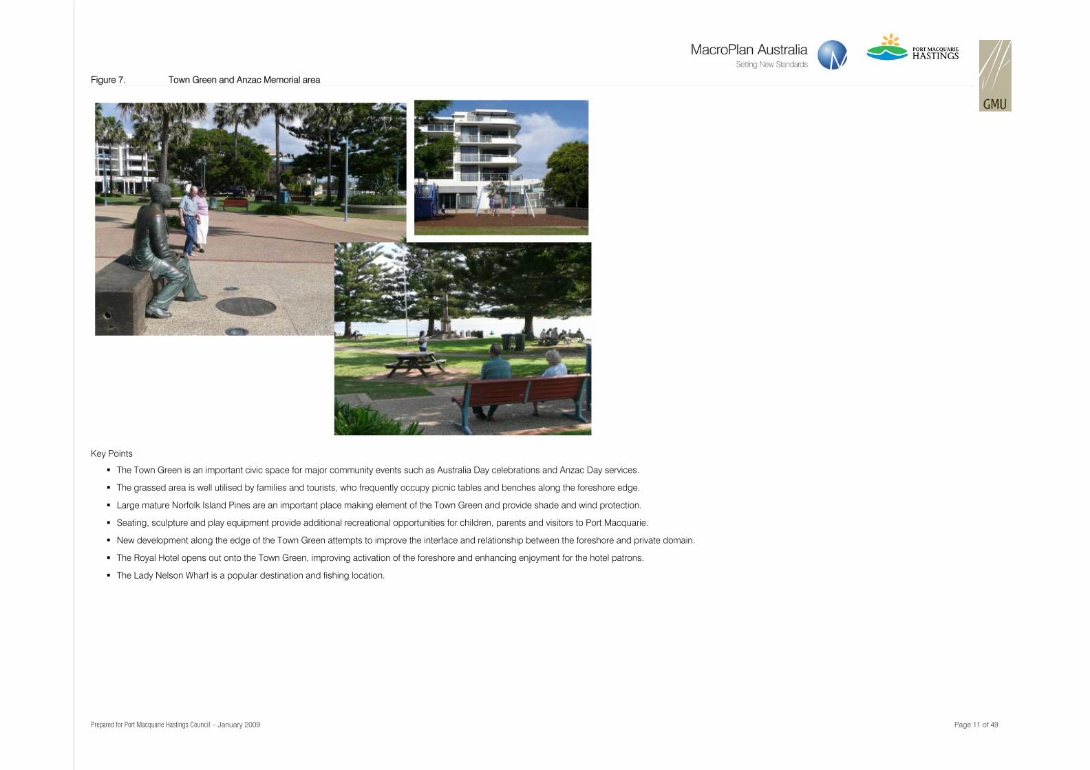
Figure 7. Town Green and Anzac Memorial area
Key Points
The Town Green is an important civic space for major community events such as Australia Day celebrations and Anzac Day services.
The grassed area is well utilised by families and tourists, who frequently occupy picnic tables and benches along the foreshore edge.
Large mature Norfolk Island Pines are an important place making element of the Town Green and provide shade and wind protection.
Seating, sculpture and play equipment provide additional recreational opportunities for children, parents and visitors to Port Macquarie.
New development along the edge of the Town Green attempts to improve the interface and relationship between the foreshore and private domain.
The Royal Hotel opens out onto the Town Green, improving activation of the foreshore and enhancing enjoyment for the hotel patrons.
The Lady Nelson Wharf is a popular destination and fishing location.
Prepared for Port Macquarie Hastings Council – January 2009 Page 12 of 49
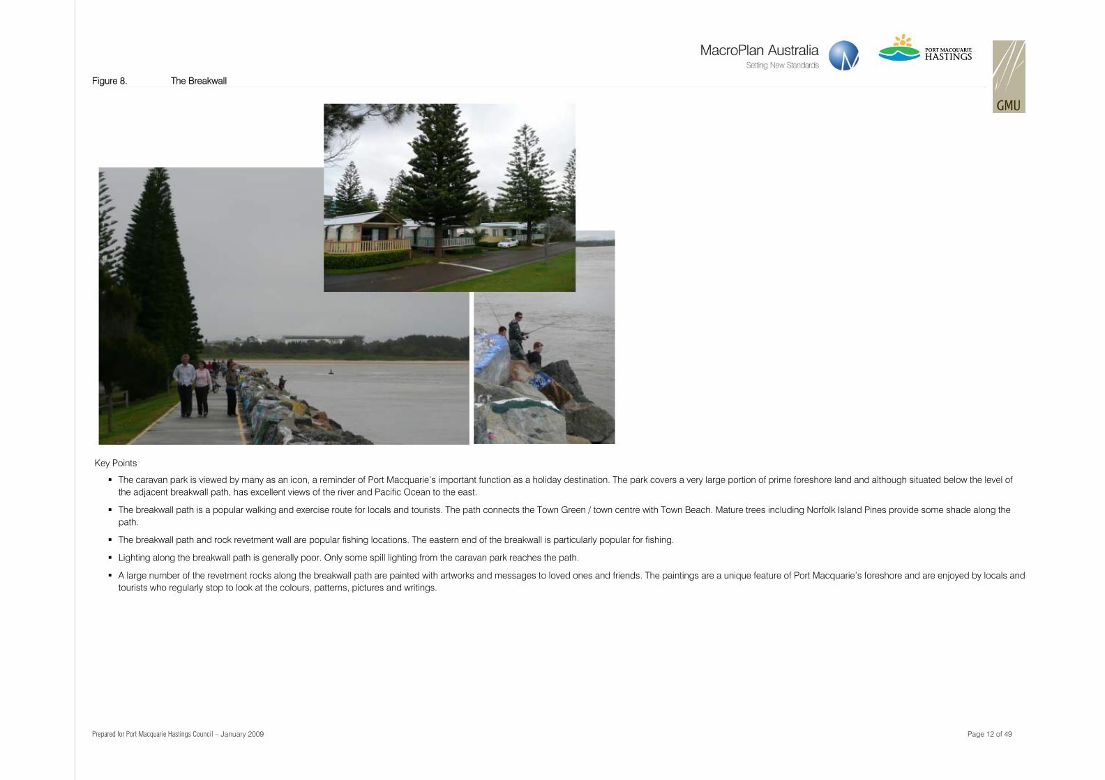
Figure 8. The Breakwall
Key Points
The caravan park is viewed by many as an icon, a reminder of Port Macquarie’s important function as a holiday destination. The park covers a very large portion of prime foreshore land and although situated below the level of the adjacent breakwall path, has excellent views of the river and Pacific Ocean to the east.
The breakwall path is a popular walking and exercise route for locals and tourists. The path connects the Town Green / town centre with Town Beach. Mature trees including Norfolk Island Pines provide some shade along the path.
The breakwall path and rock revetment wall are popular fishing locations. The eastern end of the breakwall is particularly popular for fishing.
Lighting along the breakwall path is generally poor. Only some spill lighting from the caravan park reaches the path.
A large number of the revetment rocks along the breakwall path are painted with artworks and messages to loved ones and friends. The paintings are a unique feature of Port Macquarie’s foreshore and are enjoyed by locals and tourists who regularly stop to look at the colours, patterns, pictures and writings.
Prepared for Port Macquarie Hastings Council – January 2009 Page 13 of 49
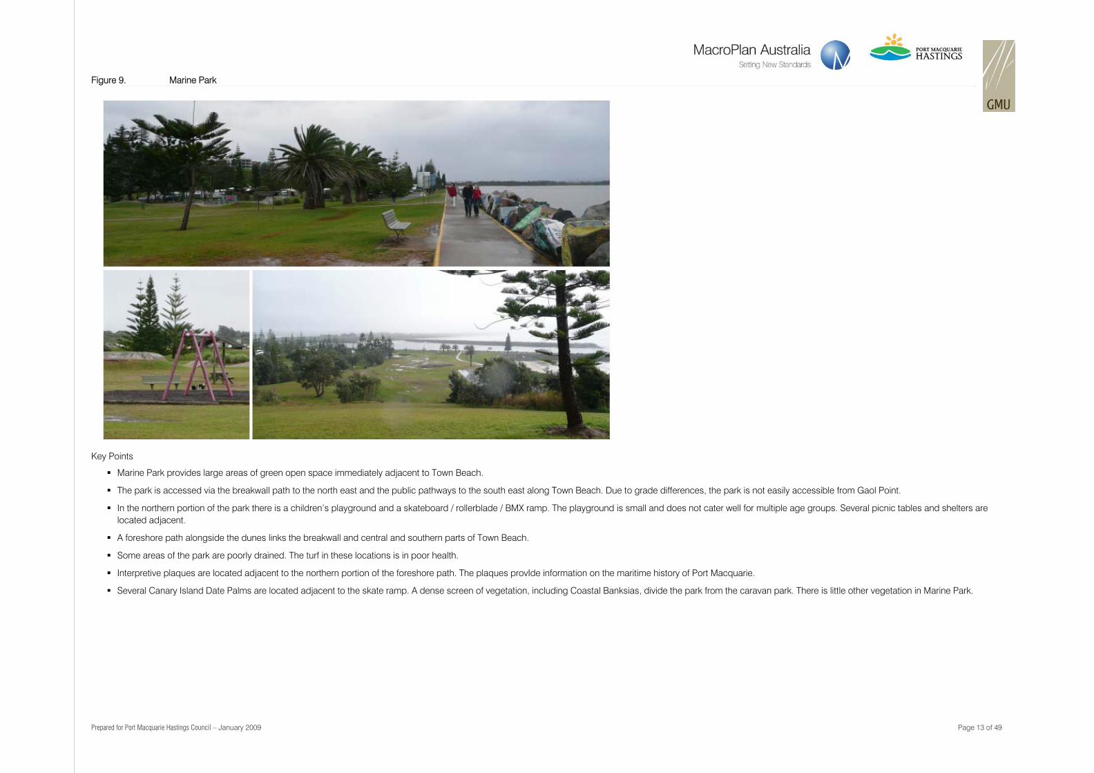
Figure 9. Marine Park
Key Points
Marine Park provides large areas of green open space immediately adjacent to Town Beach.
The park is accessed via the breakwall path to the north east and the public pathways to the south east along Town Beach. Due to grade differences, the park is not easily accessible from Gaol Point.
In the northern portion of the park there is a children’s playground and a skateboard / rollerblade / BMX ramp. The playground is small and does not cater well for multiple age groups. Several picnic tables and shelters are located adjacent.
A foreshore path alongside the dunes links the breakwall and central and southern parts of Town Beach.
Some areas of the park are poorly drained. The turf in these locations is in poor health.
Interpretive plaques are located adjacent to the northern portion of the foreshore path. The plaques provIde information on the maritime history of Port Macquarie.
Several Canary Island Date Palms are located adjacent to the skate ramp. A dense screen of vegetation, including Coastal Banksias, divide the park from the caravan park. There is little other vegetation in Marine Park.
Prepared for Port Macquarie Hastings Council – January 2009 Page 14 of 49
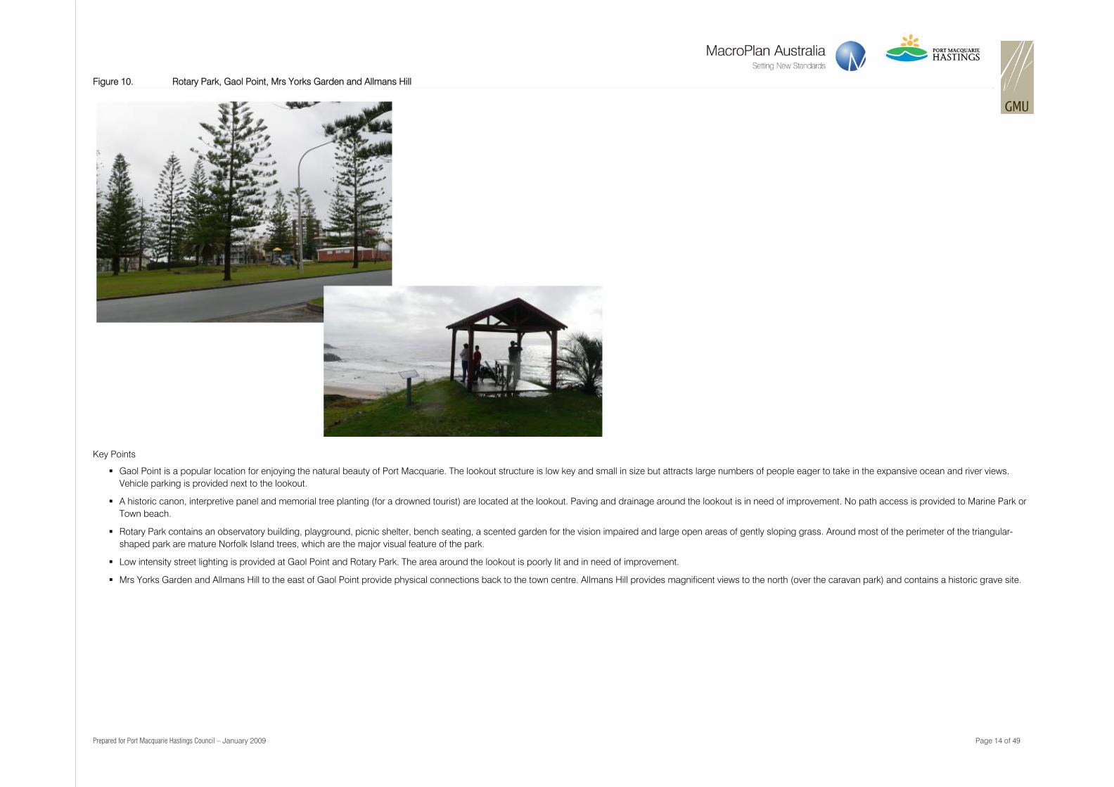
Figure 10. Rotary Park, Gaol Point, Mrs Yorks Garden and Allmans Hill
Key Points
Gaol Point is a popular location for enjoying the natural beauty of Port Macquarie. The lookout structure is low key and small in size but attracts large numbers of people eager to take in the expansive ocean and river views. Vehicle parking is provided next to the lookout.
A historic canon, interpretive panel and memorial tree planting (for a drowned tourist) are located at the lookout. Paving and drainage around the lookout is in need of improvement. No path access is provided to Marine Park or Town beach.
Rotary Park contains an observatory building, playground, picnic shelter, bench seating, a scented garden for the vision impaired and large open areas of gently sloping grass. Around most of the perimeter of the triangular-shaped park are mature Norfolk Island trees, which are the major visual feature of the park.
Low intensity street lighting is provided at Gaol Point and Rotary Park. The area around the lookout is poorly lit and in need of improvement.
Mrs Yorks Garden and Allmans Hill to the east of Gaol Point provide physical connections back to the town centre. Allmans Hill provides magnificent views to the north (over the caravan park) and contains a historic grave site.
Prepared for Port Macquarie Hastings Council – January 2009 Page 15 of 49
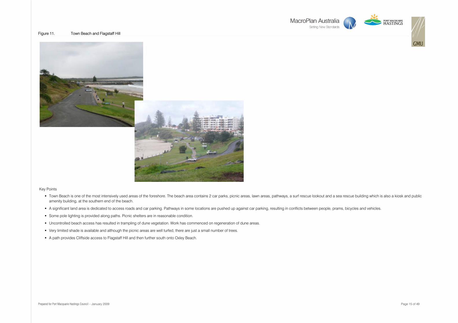
Figure 11. Town Beach and Flagstaff Hill
Key Points
Town Beach is one of the most intensively used areas of the foreshore. The beach area contains 2 car parks, picnic areas, lawn areas, pathways, a surf rescue lookout and a sea rescue building which is also a kiosk and public amenity building, at the southern end of the beach.
A significant land area is dedicated to access roads and car parking. Pathways in some locations are pushed up against car parking, resulting in conflicts between people, prams, bicycles and vehicles.
Some pole lighting is provided along paths. Picnic shelters are in reasonable condition.
Uncontrolled beach access has resulted in trampling of dune vegetation. Work has commenced on regeneration of dune areas.
Very limited shade is available and although the picnic areas are well turfed, there are just a small number of trees.
A path provides Cliffside access to Flagstaff Hill and then further south onto Oxley Beach.
Prepared for Port Macquarie Hastings Council – January 2009 Page 16 of 49
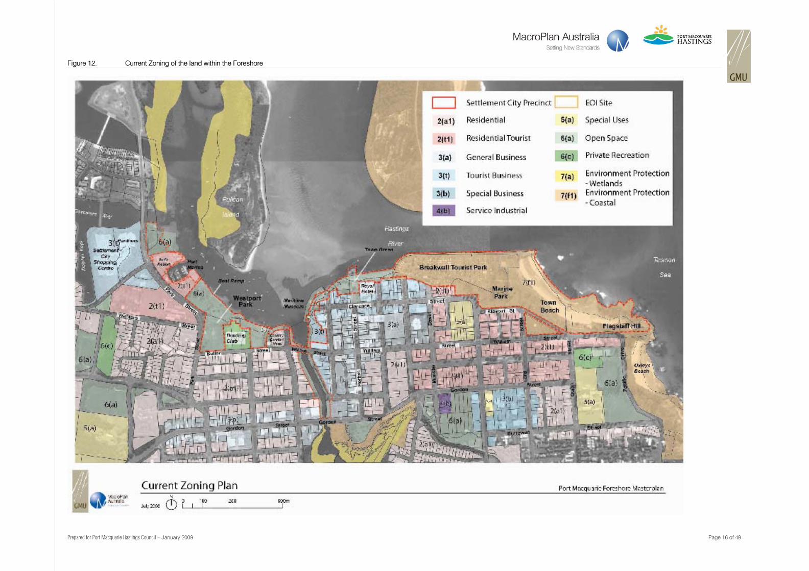
Figure 12. Current Zoning of the land within the Foreshore
Prepared for Port Macquarie Hastings Council – January 2009 Page 17 of 49
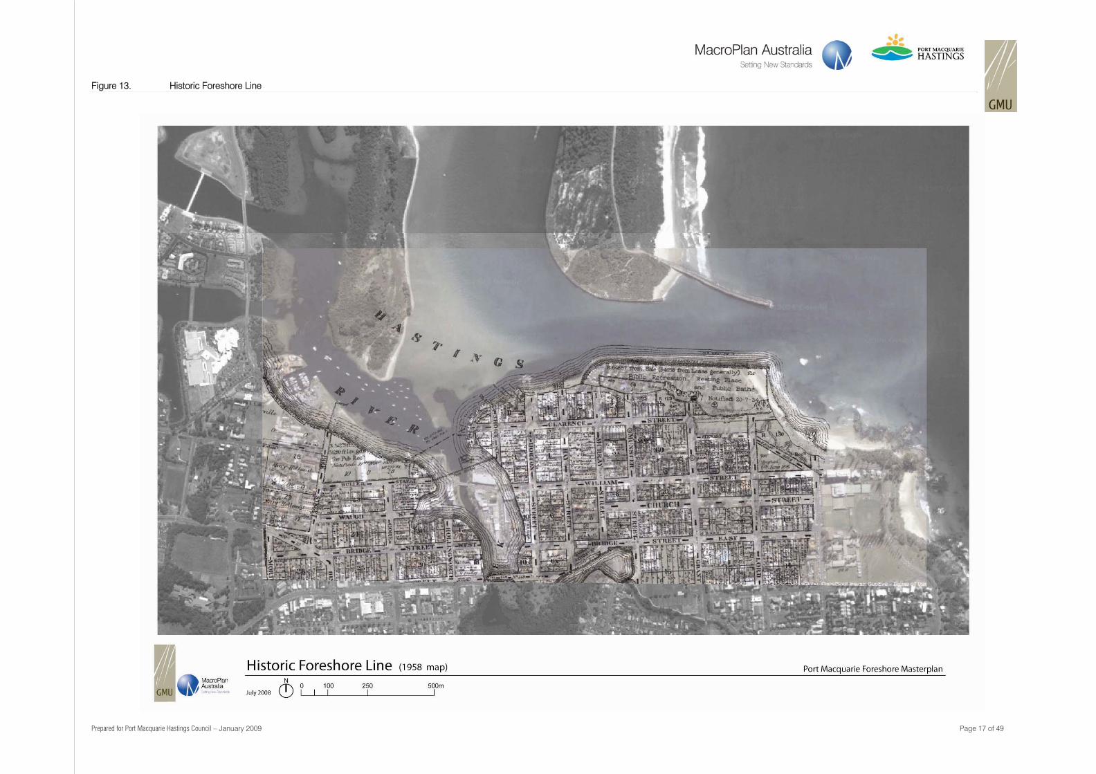
Figure 13. Historic Foreshore Line
Prepared for Port Macquarie Hastings Council – January 2009 Page 18 of 49
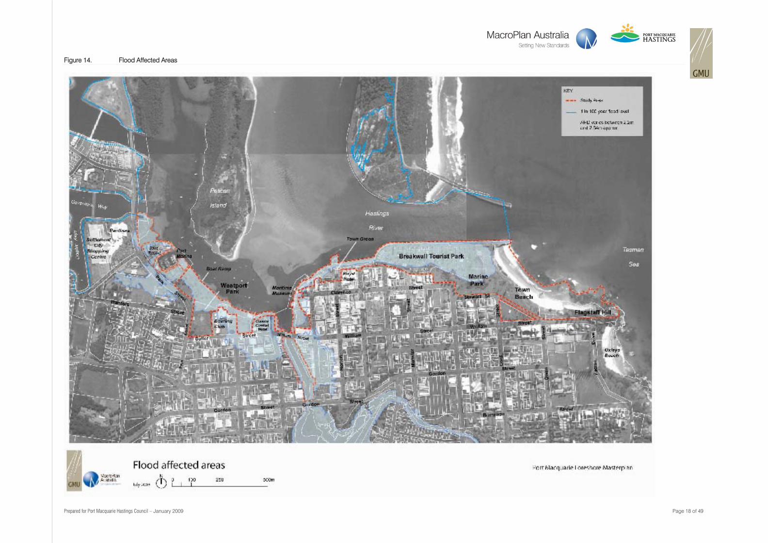
Figure 14. Flood Affected Areas
Prepared for Port Macquarie Hastings Council – January 2009 Page 19 of 49
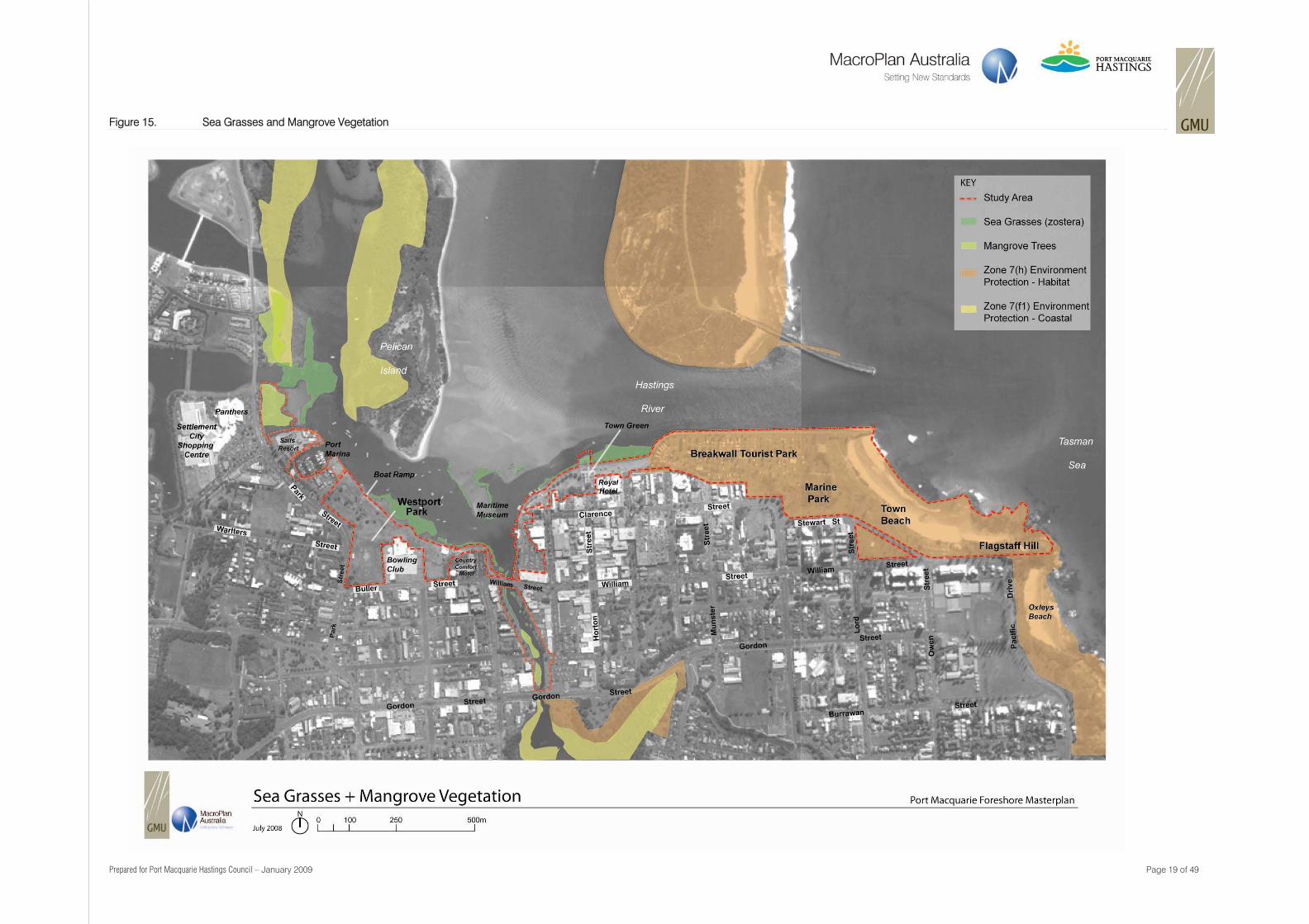
Figure 15. Sea Grasses and Mangrove Vegetation
Prepared for Port Macquarie Hastings Council – January 2009 Page 20 of 49
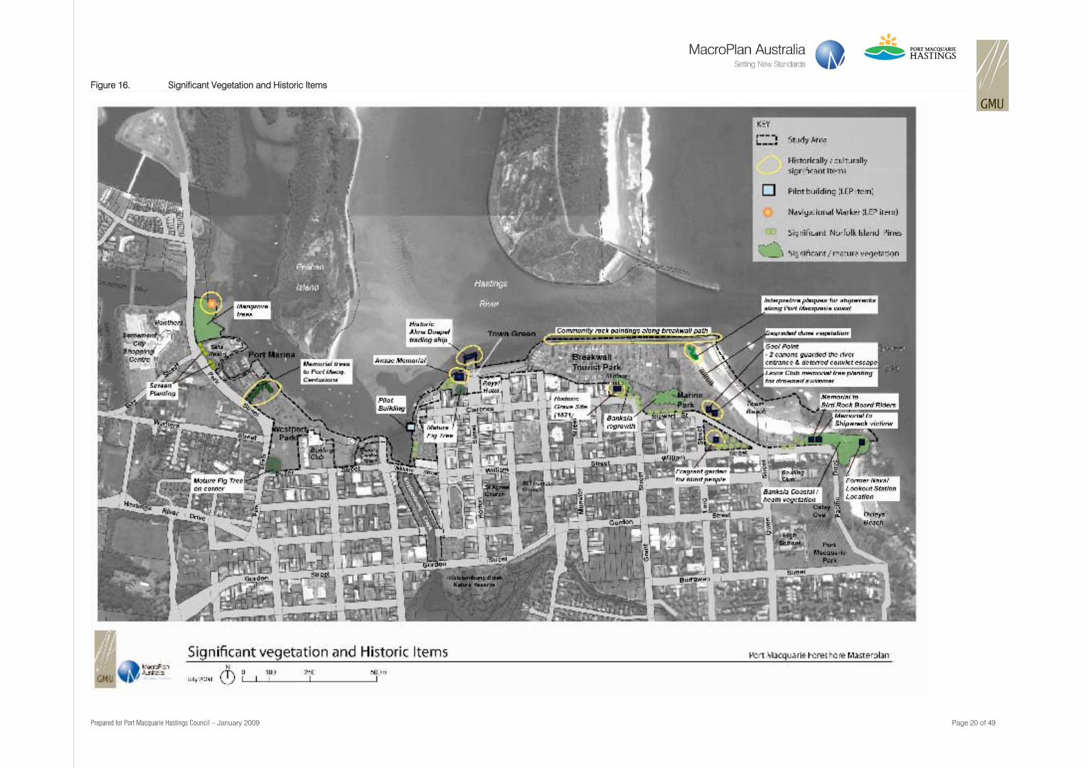
Figure 16. Significant Vegetation and Historic Items
Prepared for Port Macquarie Hastings Council – January 2009 Page 21 of 49
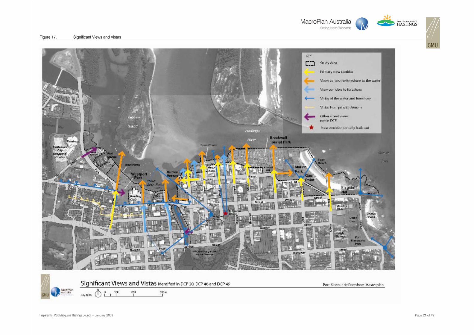
Figure 17. Significant Views and Vistas
Prepared for Port Macquarie Hastings Council – January 2009 Page 22 of 49
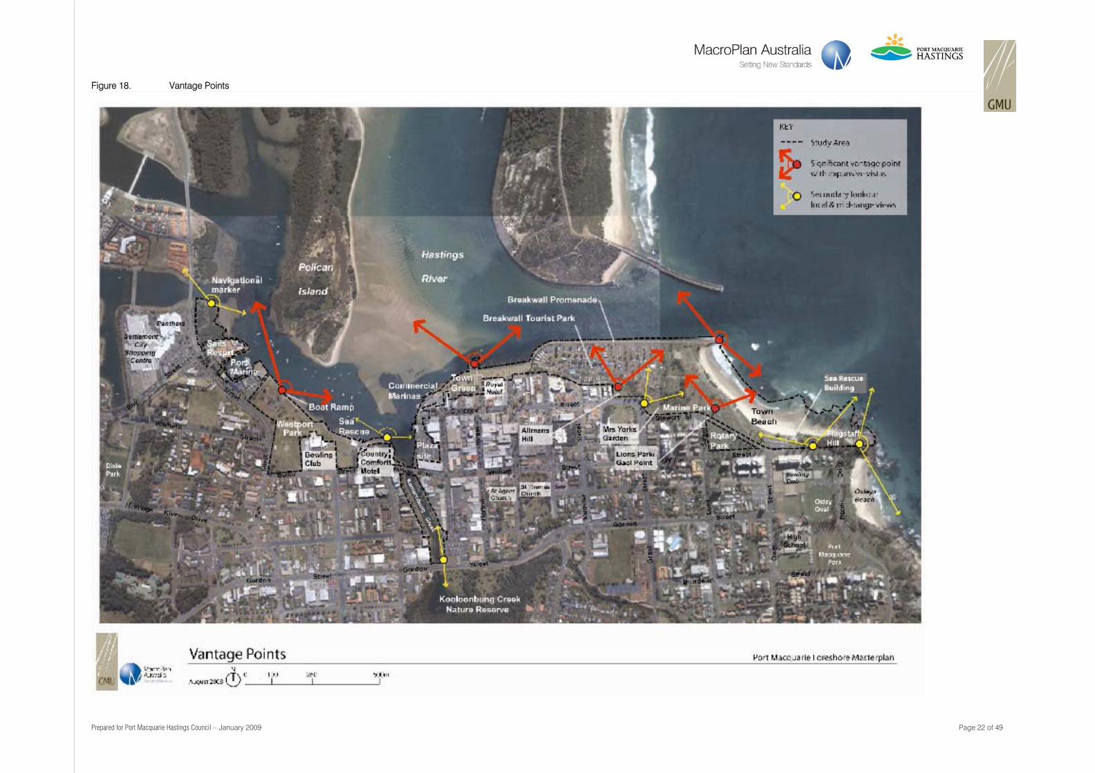
Figure 18. Vantage Points
Prepared for Port Macquarie Hastings Council – January 2009 Page 23 of 49
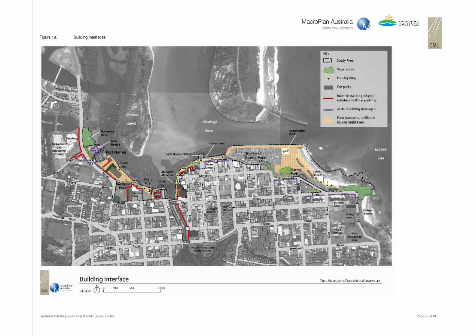
Figure 19. Building Interfaces