tillamook pud wetland delineation report tillamook ...300-foot study corridor proposed substation...
TRANSCRIPT

1S10
3000
0050
1
1S10
3000
0050
0
1S10
0000
0220
0
050
100
150
200
Feet
LEGE
ND 300-f
oot S
tudy C
orrido
rPr
opos
ed S
ubsta
tion L
ocati
onTa
x Lot1
Tax L
ot Int
ersec
ting C
orrido
r
Site L
ocati
on
\\ROSA\PROJ\TILLAMOOKPUD\412210\GIS\MAPFILES\DRAFT\WETLANDDELINEATIONREPORT\TAXLOT_MAPBOOK_1TO2400.MXD TWONG2 9/13/2012 1:56:23 PM
FIGUR
E 2u
Tax L
ot Ma
psWe
tland
Deli
neati
on R
eport
Tillam
ook-O
cean
side
Trans
miss
ion Li
neTil
lamoo
k PUD
1in =
200 f
t
Sourc
es:
1) Til
lamoo
k Cou
nty2)
Back
groun
d: Bin
g Map
s

PEMA
PEMA
PUBF
x
PFOA
050
100
150
200
Feet
LEGE
ND Loca
l Wetl
and I
nven
tory1
Natio
nal W
etlan
d Inv
entor
y1
Water
cours
e2
Poten
tial W
ater
Photo
Point
Test
Pit30
0-foo
t Stud
y Corr
idor
Prop
osed
Subs
tation
Loca
tion
Site L
ocati
on
\\ROSA\PROJ\TILLAMOOKPUD\412210\GIS\MAPFILES\DRAFT\WETLANDDELINEATIONREPORT\LWI_NWI_MAPBOOK_1TO2400.MXD TWONG2 9/13/2012 1:50:25 PM
FIGUR
E 3a
LWI a
nd N
WI W
etlan
ds M
aps
Wetla
nd D
eline
ation
Rep
ortTil
lamoo
k-Oce
ansid
eTra
nsmi
ssion
Line
Tillam
ook P
UD1in
= 20
0 ft
Sourc
es:
1) Th
e Wetl
ands
Con
serva
ncy,
2009
2) Pa
cific
North
west
Hydro
graph
y Fram
ework
, 200
53)
Back
groun
d: Bin
g Map
s

PEMC
f
PFOA
PSSC
050
100
150
200
Feet
LEGE
ND Loca
l Wetl
and I
nven
tory1
Natio
nal W
etlan
d Inv
entor
y1
Water
cours
e2
Poten
tial W
ater
Photo
Point
Test
Pit30
0-foo
t Stud
y Corr
idor
Prop
osed
Subs
tation
Loca
tion
Site L
ocati
on
\\ROSA\PROJ\TILLAMOOKPUD\412210\GIS\MAPFILES\DRAFT\WETLANDDELINEATIONREPORT\LWI_NWI_MAPBOOK_1TO2400.MXD TWONG2 9/13/2012 1:50:25 PM
FIGUR
E 3b
LWI a
nd N
WI W
etlan
ds M
aps
Wetla
nd D
eline
ation
Rep
ortTil
lamoo
k-Oce
ansid
eTra
nsmi
ssion
Line
Tillam
ook P
UD1in
= 20
0 ft
Sourc
es:
1) Th
e Wetl
ands
Con
serva
ncy,
2009
2) Pa
cific
North
west
Hydro
graph
y Fram
ework
, 200
53)
Back
groun
d: Bin
g Map
s

PFOA
PFOC
PFOC
PFOA R2
UBH
PEMC
f
PSSC
050
100
150
200
Feet
LEGE
ND Loca
l Wetl
and I
nven
tory1
Natio
nal W
etlan
d Inv
entor
y1
Water
cours
e2
Poten
tial W
ater
Photo
Point
Test
Pit30
0-foo
t Stud
y Corr
idor
Prop
osed
Subs
tation
Loca
tion
Site L
ocati
on
\\ROSA\PROJ\TILLAMOOKPUD\412210\GIS\MAPFILES\DRAFT\WETLANDDELINEATIONREPORT\LWI_NWI_MAPBOOK_1TO2400.MXD TWONG2 9/13/2012 1:50:25 PM
FIGUR
E 3c
LWI a
nd N
WI W
etlan
ds M
aps
Wetla
nd D
eline
ation
Rep
ortTil
lamoo
k-Oce
ansid
eTra
nsmi
ssion
Line
Tillam
ook P
UD1in
= 20
0 ft
Sourc
es:
1) Th
e Wetl
ands
Con
serva
ncy,
2009
2) Pa
cific
North
west
Hydro
graph
y Fram
ework
, 200
53)
Back
groun
d: Bin
g Map
s

PFOC
PFOC
PFOC
PFOC
PFOC
PFOC
PEMC
PEMC
PFOC
PSSC
PEMC
PEMC
PFOA
PFOA
PEMA
d
R2UB
H
050
100
150
200
Feet
LEGE
ND Loca
l Wetl
and I
nven
tory1
Natio
nal W
etlan
d Inv
entor
y1
Water
cours
e2
Poten
tial W
ater
Photo
Point
Test
Pit30
0-foo
t Stud
y Corr
idor
Prop
osed
Subs
tation
Loca
tion
Site L
ocati
on
\\ROSA\PROJ\TILLAMOOKPUD\412210\GIS\MAPFILES\DRAFT\WETLANDDELINEATIONREPORT\LWI_NWI_MAPBOOK_1TO2400.MXD TWONG2 9/13/2012 1:50:25 PM
FIGUR
E 3d
LWI a
nd N
WI W
etlan
ds M
aps
Wetla
nd D
eline
ation
Rep
ortTil
lamoo
k-Oce
ansid
eTra
nsmi
ssion
Line
Tillam
ook P
UD1in
= 20
0 ft
Sourc
es:
1) Th
e Wetl
ands
Con
serva
ncy,
2009
2) Pa
cific
North
west
Hydro
graph
y Fram
ework
, 200
53)
Back
groun
d: Bin
g Map
s

PEMA
d
PEMA
dh
R1UB
VPE
MCPFOC
PFOA
PEMA
d
050
100
150
200
Feet
LEGE
ND Loca
l Wetl
and I
nven
tory1
Natio
nal W
etlan
d Inv
entor
y1
Water
cours
e2
Poten
tial W
ater
Photo
Point
Test
Pit30
0-foo
t Stud
y Corr
idor
Prop
osed
Subs
tation
Loca
tion
Site L
ocati
on
\\ROSA\PROJ\TILLAMOOKPUD\412210\GIS\MAPFILES\DRAFT\WETLANDDELINEATIONREPORT\LWI_NWI_MAPBOOK_1TO2400.MXD TWONG2 9/13/2012 1:50:25 PM
FIGUR
E 3e
LWI a
nd N
WI W
etlan
ds M
aps
Wetla
nd D
eline
ation
Rep
ortTil
lamoo
k-Oce
ansid
eTra
nsmi
ssion
Line
Tillam
ook P
UD1in
= 20
0 ft
Sourc
es:
1) Th
e Wetl
ands
Con
serva
ncy,
2009
2) Pa
cific
North
west
Hydro
graph
y Fram
ework
, 200
53)
Back
groun
d: Bin
g Map
s

PABV
PEMA
d
PEMA
d
PEMA
d
PEMA
d
PEMA
dh
PEMA
dhPE
MC
PEMC
PEMC
x
050
100
150
200
Feet
LEGE
ND Loca
l Wetl
and I
nven
tory1
Natio
nal W
etlan
d Inv
entor
y1
Water
cours
e2
Poten
tial W
ater
Photo
Point
Test
Pit30
0-foo
t Stud
y Corr
idor
Prop
osed
Subs
tation
Loca
tion
Site L
ocati
on
\\ROSA\PROJ\TILLAMOOKPUD\412210\GIS\MAPFILES\DRAFT\WETLANDDELINEATIONREPORT\LWI_NWI_MAPBOOK_1TO2400.MXD TWONG2 9/13/2012 1:50:25 PM
FIGUR
E 3f
LWI a
nd N
WI W
etlan
ds M
aps
Wetla
nd D
eline
ation
Rep
ortTil
lamoo
k-Oce
ansid
eTra
nsmi
ssion
Line
Tillam
ook P
UD1in
= 20
0 ft
Sourc
es:
1) Th
e Wetl
ands
Con
serva
ncy,
2009
2) Pa
cific
North
west
Hydro
graph
y Fram
ework
, 200
53)
Back
groun
d: Bin
g Map
s
E1UB
L
E2EM
P
E2EM
P
PABV
PEMA
d
PEMA
dh
PEMA
dh
PEMA
dh
PEMA
dh
PEMC
x
PFOA
PSSC
PSSC
PSSC
PSSR R1
UBV
050
100
150
200
Feet
LEGE
ND Loca
l Wetl
and I
nven
tory1
Natio
nal W
etlan
d Inv
entor
y1
Water
cours
e2
Poten
tial W
ater
Photo
Point
Test
Pit30
0-foo
t Stud
y Corr
idor
Prop
osed
Subs
tation
Loca
tion
Site L
ocati
on
\\ROSA\PROJ\TILLAMOOKPUD\412210\GIS\MAPFILES\DRAFT\WETLANDDELINEATIONREPORT\LWI_NWI_MAPBOOK_1TO2400.MXD TWONG2 9/13/2012 1:50:25 PM
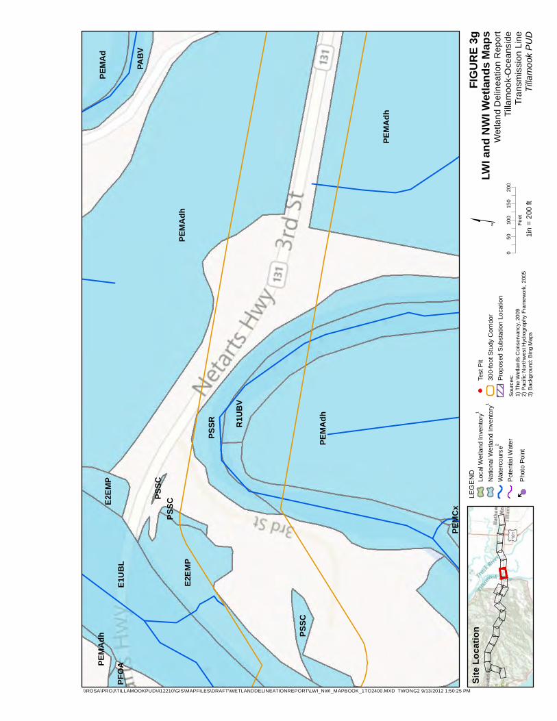
FIGUR
E 3g
LWI a
nd N
WI W
etlan
ds M
aps
Wetla
nd D
eline
ation
Rep
ortTil
lamoo
k-Oce
ansid
eTra
nsmi
ssion
Line
Tillam
ook P
UD1in
= 20
0 ft
Sourc
es:
1) Th
e Wetl
ands
Con
serva
ncy,
2009
2) Pa
cific
North
west
Hydro
graph
y Fram
ework
, 200
53)
Back
groun
d: Bin
g Map
s

E1UB
L
E2EM
N
E2EM
P
PEMA
d
PEMA
dh
PEMA
dhPE
MAdh
PEMA
dh
PEMC
PEMC
PEMC
d
PEMF
xPF
OA
PFOA
PFOA
PFOA
PSSC
PSSC
PUBH
x
PUBH
x
PUBH
xPU
BHx
R3UB
H
050
100
150
200
Feet
LEGE
ND Loca
l Wetl
and I
nven
tory1
Natio
nal W
etlan
d Inv
entor
y1
Water
cours
e2
Poten
tial W
ater
Photo
Point
Test
Pit30
0-foo
t Stud
y Corr
idor
Prop
osed
Subs
tation
Loca
tion
Site L
ocati
on
\\ROSA\PROJ\TILLAMOOKPUD\412210\GIS\MAPFILES\DRAFT\WETLANDDELINEATIONREPORT\LWI_NWI_MAPBOOK_1TO2400.MXD TWONG2 9/13/2012 1:50:25 PM
FIGUR
E 3h
LWI a
nd N
WI W
etlan
ds M
aps
Wetla
nd D
eline
ation
Rep
ortTil
lamoo
k-Oce
ansid
eTra
nsmi
ssion
Line
Tillam
ook P
UD1in
= 20
0 ft
Sourc
es:
1) Th
e Wetl
ands
Con
serva
ncy,
2009
2) Pa
cific
North
west
Hydro
graph
y Fram
ework
, 200
53)
Back
groun
d: Bin
g Map
s

PEMC
d
PFOA
PUBH
x
050
100
150
200
Feet
LEGE
ND Loca
l Wetl
and I
nven
tory1
Natio
nal W
etlan
d Inv
entor
y1
Water
cours
e2
Poten
tial W
ater
Photo
Point
Test
Pit30
0-foo
t Stud
y Corr
idor
Prop
osed
Subs
tation
Loca
tion
Site L
ocati
on
\\ROSA\PROJ\TILLAMOOKPUD\412210\GIS\MAPFILES\DRAFT\WETLANDDELINEATIONREPORT\LWI_NWI_MAPBOOK_1TO2400.MXD TWONG2 9/13/2012 1:50:25 PM
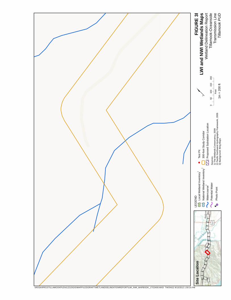
FIGUR
E 3i
LWI a
nd N
WI W
etlan
ds M
aps
Wetla
nd D
eline
ation
Rep
ortTil
lamoo
k-Oce
ansid
eTra
nsmi
ssion
Line
Tillam
ook P
UD1in
= 20
0 ft
Sourc
es:
1) Th
e Wetl
ands
Con
serva
ncy,
2009
2) Pa
cific
North
west
Hydro
graph
y Fram
ework
, 200
53)
Back
groun
d: Bin
g Map
s

PEMA
d
PEMA
dh
PFOA
PUBH
x
PUBH
x
R3UB
H
R4SB
C
050
100
150
200
Feet
LEGE
ND Loca
l Wetl
and I
nven
tory1
Natio
nal W
etlan
d Inv
entor
y1
Water
cours
e2
Poten
tial W
ater
Photo
Point
Test
Pit30
0-foo
t Stud
y Corr
idor
Prop
osed
Subs
tation
Loca
tion
Site L
ocati
on
\\ROSA\PROJ\TILLAMOOKPUD\412210\GIS\MAPFILES\DRAFT\WETLANDDELINEATIONREPORT\LWI_NWI_MAPBOOK_1TO2400.MXD TWONG2 9/13/2012 1:50:25 PM
FIGUR
E 3j
LWI a
nd N
WI W
etlan
ds M
aps
Wetla
nd D
eline
ation
Rep
ortTil
lamoo
k-Oce
ansid
eTra
nsmi
ssion
Line
Tillam
ook P
UD1in
= 20
0 ft
Sourc
es:
1) Th
e Wetl
ands
Con
serva
ncy,
2009
2) Pa
cific
North
west
Hydro
graph
y Fram
ework
, 200
53)
Back
groun
d: Bin
g Map
s

R3UB
HR4
SBC
050
100
150
200
Feet
LEGE
ND Loca
l Wetl
and I
nven
tory1
Natio
nal W
etlan
d Inv
entor
y1
Water
cours
e2
Poten
tial W
ater
Photo
Point
Test
Pit30
0-foo
t Stud
y Corr
idor
Prop
osed
Subs
tation
Loca
tion
Site L
ocati
on
\\ROSA\PROJ\TILLAMOOKPUD\412210\GIS\MAPFILES\DRAFT\WETLANDDELINEATIONREPORT\LWI_NWI_MAPBOOK_1TO2400.MXD TWONG2 9/13/2012 1:50:25 PM
FIGUR
E 3k
LWI a
nd N
WI W
etlan
ds M
aps
Wetla
nd D
eline
ation
Rep
ortTil
lamoo
k-Oce
ansid
eTra
nsmi
ssion
Line
Tillam
ook P
UD1in
= 20
0 ft
Sourc
es:
1) Th
e Wetl
ands
Con
serva
ncy,
2009
2) Pa
cific
North
west
Hydro
graph
y Fram
ework
, 200
53)
Back
groun
d: Bin
g Map
s
050
100
150
200
Feet
LEGE
ND Loca
l Wetl
and I
nven
tory1
Natio
nal W
etlan
d Inv
entor
y1
Water
cours
e2
Poten
tial W
ater
Photo
Point
Test
Pit30
0-foo
t Stud
y Corr
idor
Prop
osed
Subs
tation
Loca
tion
Site L
ocati
on
\\ROSA\PROJ\TILLAMOOKPUD\412210\GIS\MAPFILES\DRAFT\WETLANDDELINEATIONREPORT\LWI_NWI_MAPBOOK_1TO2400.MXD TWONG2 9/13/2012 1:50:25 PM
FIGUR
E 3l
LWI a
nd N
WI W
etlan
ds M
aps
Wetla
nd D
eline
ation
Rep
ortTil
lamoo
k-Oce
ansid
eTra
nsmi
ssion
Line
Tillam
ook P
UD1in
= 20
0 ft
Sourc
es:
1) Th
e Wetl
ands
Con
serva
ncy,
2009
2) Pa
cific
North
west
Hydro
graph
y Fram
ework
, 200
53)
Back
groun
d: Bin
g Map
s
050
100
150
200
Feet
LEGE
ND Loca
l Wetl
and I
nven
tory1
Natio
nal W
etlan
d Inv
entor
y1
Water
cours
e2
Poten
tial W
ater
Photo
Point
Test
Pit30
0-foo
t Stud
y Corr
idor
Prop
osed
Subs
tation
Loca
tion
Site L
ocati
on
\\ROSA\PROJ\TILLAMOOKPUD\412210\GIS\MAPFILES\DRAFT\WETLANDDELINEATIONREPORT\LWI_NWI_MAPBOOK_1TO2400.MXD TWONG2 9/13/2012 1:50:25 PM
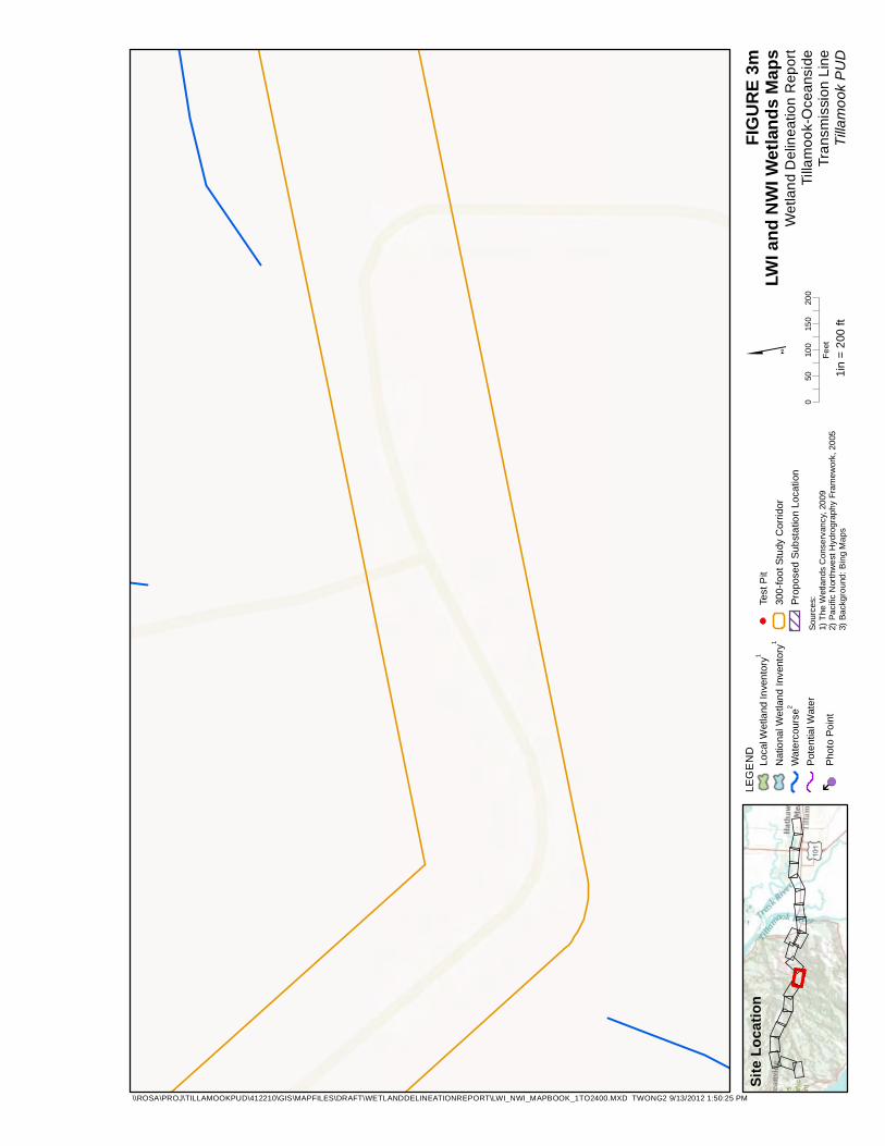
FIGUR
E 3m
LWI a
nd N
WI W
etlan
ds M
aps
Wetla
nd D
eline
ation
Rep
ortTil
lamoo
k-Oce
ansid
eTra
nsmi
ssion
Line
Tillam
ook P
UD1in
= 20
0 ft
Sourc
es:
1) Th
e Wetl
ands
Con
serva
ncy,
2009
2) Pa
cific
North
west
Hydro
graph
y Fram
ework
, 200
53)
Back
groun
d: Bin
g Map
s

PW13
68 69
050
100
150
200
Feet
LEGE
ND Loca
l Wetl
and I
nven
tory1
Natio
nal W
etlan
d Inv
entor
y1
Water
cours
e2
Poten
tial W
ater
Photo
Point
Test
Pit30
0-foo
t Stud
y Corr
idor
Prop
osed
Subs
tation
Loca
tion
Site L
ocati
on
\\ROSA\PROJ\TILLAMOOKPUD\412210\GIS\MAPFILES\DRAFT\WETLANDDELINEATIONREPORT\LWI_NWI_MAPBOOK_1TO2400.MXD TWONG2 9/13/2012 1:50:25 PM
FIGUR
E 3n
LWI a
nd N
WI W
etlan
ds M
aps
Wetla
nd D
eline
ation
Rep
ortTil
lamoo
k-Oce
ansid
eTra
nsmi
ssion
Line
Tillam
ook P
UD1in
= 20
0 ft
Sourc
es:
1) Th
e Wetl
ands
Con
serva
ncy,
2009
2) Pa
cific
North
west
Hydro
graph
y Fram
ework
, 200
53)
Back
groun
d: Bin
g Map
s

PW13
PW14
PW14
68
71
69
R3UB
H
050
100
150
200
Feet
LEGE
ND Loca
l Wetl
and I
nven
tory1
Natio
nal W
etlan
d Inv
entor
y1
Water
cours
e2
Poten
tial W
ater
Photo
Point
Test
Pit30
0-foo
t Stud
y Corr
idor
Prop
osed
Subs
tation
Loca
tion
Site L
ocati
on
\\ROSA\PROJ\TILLAMOOKPUD\412210\GIS\MAPFILES\DRAFT\WETLANDDELINEATIONREPORT\LWI_NWI_MAPBOOK_1TO2400.MXD TWONG2 9/13/2012 1:50:25 PM
FIGUR
E 3o
LWI a
nd N
WI W
etlan
ds M
aps
Wetla
nd D
eline
ation
Rep
ortTil
lamoo
k-Oce
ansid
eTra
nsmi
ssion
Line
Tillam
ook P
UD1in
= 20
0 ft
Sourc
es:
1) Th
e Wetl
ands
Con
serva
ncy,
2009
2) Pa
cific
North
west
Hydro
graph
y Fram
ework
, 200
53)
Back
groun
d: Bin
g Map
s
PW14
PW14
71
72 73
PSSC
R3UB
H
050
100
150
200
Feet
LEGE
ND Loca
l Wetl
and I
nven
tory1
Natio
nal W
etlan
d Inv
entor
y1
Water
cours
e2
Poten
tial W
ater
Photo
Point
Test
Pit30
0-foo
t Stud
y Corr
idor
Prop
osed
Subs
tation
Loca
tion
Site L
ocati
on
\\ROSA\PROJ\TILLAMOOKPUD\412210\GIS\MAPFILES\DRAFT\WETLANDDELINEATIONREPORT\LWI_NWI_MAPBOOK_1TO2400.MXD TWONG2 9/13/2012 1:50:25 PM
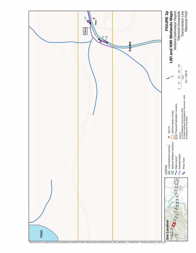
FIGUR
E 3p
LWI a
nd N
WI W
etlan
ds M
aps
Wetla
nd D
eline
ation
Rep
ortTil
lamoo
k-Oce
ansid
eTra
nsmi
ssion
Line
Tillam
ook P
UD1in
= 20
0 ft
Sourc
es:
1) Th
e Wetl
ands
Con
serva
ncy,
2009
2) Pa
cific
North
west
Hydro
graph
y Fram
ework
, 200
53)
Back
groun
d: Bin
g Map
s

PW15
74
PSSC
050
100
150
200
Feet
LEGE
ND Loca
l Wetl
and I
nven
tory1
Natio
nal W
etlan
d Inv
entor
y1
Water
cours
e2
Poten
tial W
ater
Photo
Point
Test
Pit30
0-foo
t Stud
y Corr
idor
Prop
osed
Subs
tation
Loca
tion
Site L
ocati
on
\\ROSA\PROJ\TILLAMOOKPUD\412210\GIS\MAPFILES\DRAFT\WETLANDDELINEATIONREPORT\LWI_NWI_MAPBOOK_1TO2400.MXD TWONG2 9/13/2012 1:50:25 PM
FIGUR
E 3q
LWI a
nd N
WI W
etlan
ds M
aps
Wetla
nd D
eline
ation
Rep
ortTil
lamoo
k-Oce
ansid
eTra
nsmi
ssion
Line
Tillam
ook P
UD1in
= 20
0 ft
Sourc
es:
1) Th
e Wetl
ands
Con
serva
ncy,
2009
2) Pa
cific
North
west
Hydro
graph
y Fram
ework
, 200
53)
Back
groun
d: Bin
g Map
s

050
100
150
200
Feet
LEGE
ND Loca
l Wetl
and I
nven
tory1
Natio
nal W
etlan
d Inv
entor
y1
Water
cours
e2
Poten
tial W
ater
Photo
Point
Test
Pit30
0-foo
t Stud
y Corr
idor
Prop
osed
Subs
tation
Loca
tion
Site L
ocati
on
\\ROSA\PROJ\TILLAMOOKPUD\412210\GIS\MAPFILES\DRAFT\WETLANDDELINEATIONREPORT\LWI_NWI_MAPBOOK_1TO2400.MXD TWONG2 9/13/2012 1:50:25 PM
FIGUR
E 3r
LWI a
nd N
WI W
etlan
ds M
aps
Wetla
nd D
eline
ation
Rep
ortTil
lamoo
k-Oce
ansid
eTra
nsmi
ssion
Line
Tillam
ook P
UD1in
= 20
0 ft
Sourc
es:
1) Th
e Wetl
ands
Con
serva
ncy,
2009
2) Pa
cific
North
west
Hydro
graph
y Fram
ework
, 200
53)
Back
groun
d: Bin
g Map
s

050
100
150
200
Feet
LEGE
ND Loca
l Wetl
and I
nven
tory1
Natio
nal W
etlan
d Inv
entor
y1
Water
cours
e2
Poten
tial W
ater
Photo
Point
Test
Pit30
0-foo
t Stud
y Corr
idor
Prop
osed
Subs
tation
Loca
tion
Site L
ocati
on
\\ROSA\PROJ\TILLAMOOKPUD\412210\GIS\MAPFILES\DRAFT\WETLANDDELINEATIONREPORT\LWI_NWI_MAPBOOK_1TO2400.MXD TWONG2 9/13/2012 1:50:25 PM
FIGUR
E 3s
LWI a
nd N
WI W
etlan
ds M
aps
Wetla
nd D
eline
ation
Rep
ortTil
lamoo
k-Oce
ansid
eTra
nsmi
ssion
Line
Tillam
ook P
UD1in
= 20
0 ft
Sourc
es:
1) Th
e Wetl
ands
Con
serva
ncy,
2009
2) Pa
cific
North
west
Hydro
graph
y Fram
ework
, 200
53)
Back
groun
d: Bin
g Map
s

PW17
70
82
R4SB
C
050
100
150
200
Feet
LEGE
ND Loca
l Wetl
and I
nven
tory1
Natio
nal W
etlan
d Inv
entor
y1
Water
cours
e2
Poten
tial W
ater
Photo
Point
Test
Pit30
0-foo
t Stud
y Corr
idor
Prop
osed
Subs
tation
Loca
tion
Site L
ocati
on
\\ROSA\PROJ\TILLAMOOKPUD\412210\GIS\MAPFILES\DRAFT\WETLANDDELINEATIONREPORT\LWI_NWI_MAPBOOK_1TO2400.MXD TWONG2 9/13/2012 1:50:25 PM
FIGUR
E 3t
LWI a
nd N
WI W
etlan
ds M
aps
Wetla
nd D
eline
ation
Rep
ortTil
lamoo
k-Oce
ansid
eTra
nsmi
ssion
Line
Tillam
ook P
UD1in
= 20
0 ft
Sourc
es:
1) Th
e Wetl
ands
Con
serva
ncy,
2009
2) Pa
cific
North
west
Hydro
graph
y Fram
ework
, 200
53)
Back
groun
d: Bin
g Map
s

PW18
70
R4SB
C
050
100
150
200
Feet
LEGE
ND Loca
l Wetl
and I
nven
tory1
Natio
nal W
etlan
d Inv
entor
y1
Water
cours
e2
Poten
tial W
ater
Photo
Point
Test
Pit30
0-foo
t Stud
y Corr
idor
Prop
osed
Subs
tation
Loca
tion
Site L
ocati
on
\\ROSA\PROJ\TILLAMOOKPUD\412210\GIS\MAPFILES\DRAFT\WETLANDDELINEATIONREPORT\LWI_NWI_MAPBOOK_1TO2400.MXD TWONG2 9/13/2012 1:50:25 PM
FIGUR
E 3u
LWI a
nd N
WI W
etlan
ds M
aps
Wetla
nd D
eline
ation
Rep
ortTil
lamoo
k-Oce
ansid
eTra
nsmi
ssion
Line
Tillam
ook P
UD1in
= 20
0 ft
Sourc
es:
1) Th
e Wetl
ands
Con
serva
ncy,
2009
2) Pa
cific
North
west
Hydro
graph
y Fram
ework
, 200
53)
Back
groun
d: Bin
g Map
s