the south china sea || tectonics and deposits of the cenozoic era in the south china sea
TRANSCRIPT
Energy Vol. 6, No. 11, pp. 1093-1098, 1981 Printed in Great Britain.
0360-5442/81/111093-06$02.00/0 Pergamon Press Ltd.
TECTONICS AND DEPOSITS OF THE CENOZOIC ERA IN THE SOUTH CHINA SEA
Luo ZHETAN, ZHANG RUIXIANG, and H E LIANSHENG
Department of Petroleum Geology, Changdu, China
Abstract—The marginal sea along the western fringe of the Pacific Ocean is one of the most magnificant regions of global tectonics. In the plate tectonics pattern, a marginal sea is located in the tension-rifted region of the continental plate adjacent to the plate convergence boundary. Among such marginal seas, the South China Sea is probably the most complex, and one of the most important oil-and-gas provinces in Southeast Asia. This paper, based on results from geophysical surveys and drilling activities as well as other available data, is intended to describe briefly the tectonics and deposits of the Cenozoic Era in the South China Sea.
1. THE TECTONIC SCHEME PRIORTO THE CENOZOIC IN THE SOUTH CHINA SEA AND ADJACENT REGIONS
The South China Sea, at the southeastern end of the Eurasian plate, is a junction region for the Eurasian, Pacific and Indo-Australian plates. The motion and interaction of the three plates directly controlled the genesis and development of tectonism in the South China Sea and adjacent regions.
In the late Mesozoic, the paired metamorphic belts, High Pressure (HP), Low Tem-perature (LT) glaucophane-schist on the east and Low Pressure (LP), High Temperature (HT) andalusite-sillimanite gneiss on the west, were formed with a complex sequence of Late Paleozoic and Mesozoic ophiolite suites and flysch. The Pliocine-Pleistocene melance, i.e., the Lichi Formation and the Kending Formation, occurs extensively along the coastal mountain range of Taiwan. The volcanic rocks occur as belts on the island arc. All of this geological evidence implies that the Taiwan-Philippine arc has undergone a long, complex subduction process since the late Paleozoic.
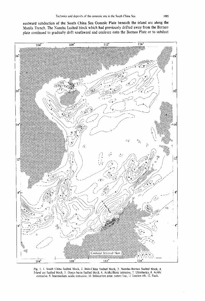
The calc-alkaline volcanic series of Late Jurassic age, including such rock types as andesite, dacite, rhyolite and ignimbrite, the andalusite-sillimanite schists in the metamorphic rocks associated with the migmatite of Mesozoic age onshore along the northern fringe of the South China Sea, and the sillimanite metamorphic grannulite of Paleozoic age along the border of Guangdong and Guangxi, are all distributed in a northeast to southeast direction. This evidence indicates the existence of a magmatic island arc, and, more likely, the relics of collision and consumption between microplates, i.e., faulted blocks, within the Eurasian plate. It was the process of collision and consumption that welded the Guangdong and Guangxi faulted blocks with different geological evolutionary histories into one huge entity, the South China faulted block. Marine geophysical investigations have revealed that the tectonic units of the South China faulted block extend southward, and constitute the basement of the Zisha and Zonsha Islands.
Along the western fringe of the South China Sea, the Indo-China faulted block (shield) which had been separated from the South China fault block, collided with the South China fault block along the Ailau mountain suture-line to the northwest. The Ailau mountain suture-line, which was a complex subduction zone, extends northward to Yunnan and Qinghai Provinces, and southward across the Beibu Gulf, reaching the southern edge of the Xisha Islands. Crushed ophiolite suites, well-developed spilitic keratophyre series, and metamorphic, and acidic and alkaline intrusive bodies are common along the suture line. The pronounced change in the characteristics of geophysical field and the marked difference in crustal thickness from one side of the suture line to the other are further evidence of the structural discontinuity. Additionally, the sedimentary lithofacies and paleontological facies are entirely different on either side of the suture line.
Tectonic activity was extremely complex and covered a long period of time—approximately commencing in Hercynian, and ending in early Himalayan. The Northern Mekong River suture
1093
1094 Luo ZHETAN et al.
line, which represents the zone of collision between the Indo-China faulted block and the Western Thailand Precambrian faulted block, underwent alterations of complex processes, such as sea-floor spreading, subduction, and consumption from Paleozoic onwards, finally culminat-ing in convergence and collision during Jurassic-Palaeogene time.
It appears that the Indo-China faulted block did not coalesce with the Eurasian plate until early Himalayan time. A series of parallel crushed zones resulted from the collision of the faulted blocks. The Triassic melange belts in Northern Vietnam and Napo-Longshou, and in Guangxi Province represent the crushed zone situated parallel to the northeastern boundary of the faulted block. The so-called western South China Sea megafault along the eastern flank of the Indo-China faulted block is not supported by the magnetic anomalies which indicate the eastward prolongation of the faulted block as the basement of the western South China Sea extending to the south of the Nansha Islands.
The suture line around the Borneo faulted block is represented by the ophiolite suite of Cretaceous-Early Tertiary age distributed on Natuna and Meratus Islands and along the Lupar River. To the northwest, the Borneo faulted block was joined with the Indo-China faulted block along the fault belt trending east northeast from Anambas to Natuna Islands. Along the suture line, Mesozoic magmatism was frequent, and basalts are widespread. Distinct geophysical differences from one side of the fault belt to the other indicate further that the Anambas-Natuna fault belt is probably a suture line.
Based on the features of the magnetic basement and the characteristics of the sedimentary lithofacies, the Nansha faulted block was originally a component of Borneo, and through a complex process of divergence and convergence, assumed its present day configuration.
On the southeastern side of the South China Sea, Mindoro Island and Palawan Island to where the continental shelf is terminated by the Ulugan fault, are continental fragments composed of a Paleozoic metamorphic complex.1 The Early Tertiary melange and ophiolite suites, outcropping in southern Palawan, however, may be correlated with those observed in the Zambales Ranges of the Philippines in northeast Borneo. The Ulugan fault then, which itself has been displaced by a series of slip faults, is a suture line of late Cretaceous-Early Tertiary ages.
In summary, all these faulted blocks extend seaward and constitute the basement of the South China Sea. The South China Sea basement is thus a foundered continental crust craton comprised of four units, i.e., the South China faulted block on the north, the Indo-China faulted block on the west, the Nansha-Borneo faulted blocks on the south, and island arc fragments on the east. Those four units formed the southeastern fringe of the Eurasian plate in Mesozoic time.
2. THE EVOLUTION OF THE SOUTH CHINA SEA PLATE AND THE DEPOSITS OF THE CENOZOIC
At the end of the Mesozoic a clockwise rotation of the Eurasia plate took place. As a result the southward displacement of the eastern front of the Durasian plate led to the segmenting of the South China Sea Craton which was formed at the end of the Mesozoic. Ben-Avraham and Uyeda 2 discovered an east northeast magnetic lineation in the central basin of the South China Sea and Taylor et al} confirmed that the spreading ridge in the South China Sea was located at approximately 15° latitude and the spreading occurred from Oligocene to Miocene time (17-32 m.y.B.P.). Drifting in the northern and northwestern sides of the South China Sea gave rise to the east northeast-rifted Xisha Trough, situated parallel to the spreading ridge.
The previous tectonic pattern of the basin was wholly modified by Mesozoic ocean floor spreading and widespread rifting. The oceanic crust within the basin became evident in the central South China Sea and the divergent continental margin appeared along both the southern and northern fringes of the basin. The new faulted blocks, Nansha, Zhongsha and Xisha, successively came into existence. Vertical motion along the east northeast fault and the previous northeast, east northeast, northwest and northsouth faults caused by regional tension, appeared in the form of grabens especially in the hinge belts between the faulted blocks.
Accompanying the west northwest drifting of the Pacific Plate and northward drifting of the Indo-Australian Plate during early Pleiocene-Pleistocene time was the obduction of the Taiwan-Philippine island arc over the South China Sea Basin and the commencement of
Tectonics and deposits of the cenozoic era in the South China Sea 1095
eastward subduction of the South China Sea Oceanic Plate beneath the island arc along the
Manila Trench. The Nansha faulted block which had previously drifted away from the Borneo
plate continued to gradually drift southward and coalesce onto the Borneo Plate or to subduct
Fig. 1.1. South China faulted block, 2. Indo-China faulted block, 3. Nansha-Borneo faulted block, 4. Island arc faulted block, 5. Ocean basin faulted block, 6. Acidic/Basic intrusive, 7. Ultrabasics, 8. Acidic
extrusive, 9. Intermediate acidic extrusive, 10. Subduction zone, suture line, 11 Tension rift, 12. Fault.
1096 Luo ZHETAN et al.
beneath the Palawan Trough (Figure 1). The following must be emphatically pointed out: (1) the direction of spreading on the South China Sea is perpendicular to that of the island arc; (2) the margins of the spreading ridge are diverging to the north and south; (3) no subduction is now discernible along the northern flank, and high heat flow is evident along the continental margin; and (4) a rifted valley parallels the spreading ridge along the Xisha Trough. All of these geological conditions cannot be interpreted by hypotheses of marginal sea genesis, such as the consumption of sea ridges, ocean basin remnants, back-arc spreading of the slip from a transform fault. It seems that all these geological events were related to the suggested tectonic mechanism described in the previous section.
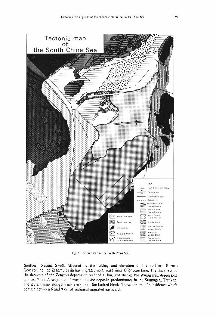
The genesis and development of the Cenozoic sedimentary basins were directly controlled by the evolution of the South China Sea Plate (Figure 2). Although Cenozoic sediments are widespread in the South China Sea, they predominate on the margins of all the faulted blocks and along the faults in the faulted blocks, where regional horizontal tension led to the formation of grabens and horsts. On the southern fringe of the southern China faulted block in the northern part of the South China Sea, a giant sedimentary belt developed trending northeast-east northeast with isolated settling centers in the Beibu Gulf southeast of Hainan, the Pearl River estuary, and the Taiwan shoal.
The terrestrial and transitional facies deposits of Eocene and/or Oligocene age overlie various types of basement. Large-scale transgression reached the northern part of the South China Sea at the end of the Oligocene and led to littoral and neritic deposits with a thickness of 4-6 km and a maximum thickness of 8 km or more. The belt was divided into a western and eastern portion by a central rift which was the southward prolongation of the Haiphong rift onshore. Its western portion includes the southeastern part of Hainan and Depression No. 3 of the Pearl River Estuary Basin, and is characterized by the northeast structural trends caused by basement tectonism. The eastern portion includes Depressions No. 1 and No. 2 of the Pearl River Estuary Basin and Taiwan Shoal and is characterized by east northeast trends parallel to the direction of the spreading ridge or magnetic lineation.
On the northern continental rise of the Central Basin, a wedge-like sedimentary basin (southern Dongsha sedimentary basin) developed. This basin is deep to the south and shallow to the north and has a sediment thickness of 1-2.5 km dominated by turbidities as indicated by the velocity pattern. The parallel trend of the eastern Dongsha sedimentary basin with the southern sedimentary belt on the southern faulted block suggests a close relationship between tension faults, depression faults, and deposition.
The characteristics of the Yinggehai sedimentary basin on the northeastern flank of the Indo-China faulted block are different from those of the South China faulted block. The basin developed on the Ailau palaeosuture, in a northwestward trending graben belt known as the Hong River—Yinggehai fault. This symmetrical semi-graben-shaped basin contains more than 10 km of predominantly Cenozoic Marine clastic1 which increase in thickness to the south. The basin is asymmetrical and of semi-graben shape. In post-Miocene time the Yinggden basin and the southeastern part of the Hainan basin were gradually joined.
Cenozoic sedimentary basins, such as the faulted, subsided basins in the eastern South China Sea, between Natuna and the Mekong River along the southeastern flank of the Indo-China faulted block was complicated by later rifting in the western South China Sea. The thickness of Cenozoic sediments in the basin is between 3 and 6 km.
Along the western fringe of the Indo-China faulted block lies the well-known Gulf of Thailand Basin, covering an area of about 2,420,000 km 2. The main trend of this basin is northwest, parallel to the western boundary of the faulted block. The basin is composed of three depressions: the Chumphon Basin, the Malay Basin, and the Pattano Trough. The basin extends southward and becomes two small depressions that trend east northeast parallel to the Anambas-Natuna fault. The relatively rapid subsidence of the basin led to a 6 km thick section of Oligocene sediments.
A series of sedimentary basins developed around the Nansha-Borneo faulted block to the south of the South China Sea. To the north lies the Zengmu Basin, and to the east the Stantagan, the Tarakan and the Kutai Basins. The Zengmu Basin is composed of two large depressions—the Wuanantan depression and the Zengmu depression. The former trends northwest and the latter northeast. Between the two depressions lie the Beikon Shoal and the
Tectonics and deposits of the cenozoic era in the South China Sea 1097
Fig. 2. Tectonic map of the South China Sea.
Southern Natuna Swell. Affected by the folding and elevation of the northern Borneo Geosyncline, the Zengmu basin has migrated northward since Oligocene time. The thickness of the deposits of the Zengmu depression reached 10 km, and that of the Wuanantan depression approx. 7 km. A sequence of marine elastic deposits predominates in the Stantagan, Tarakan, and Kutai basins along the eastern side of the faulted block. These centers of subsidence which contain between 6 and 9 km of sediment migrated eastward.
1098 Luo ZHETAN et al.
Along the margin of Palawan Island lie two parallel, northeast-trending depressions with Neogene sediments up to 5 km in thickness. The northeast trending faults in the Nansha and Xisha faulted blocks produced elongated, small, faulted depressions. The northwestern Luzon Trough seems to be a front-arc basin resulting from eastward subduction of the South China Sea Oceanic Plate during Cenozoic time. A 2 km thick sequence of Pleistocene-Quaternary clastic sediments was deposited there. In the central basin oceanic plate, exclusive of the basin on the southern Dongsha continental rise, only very thin pelagic sediments occur, with a thickness of less than 1 km.
In summarizing the characteristics of the distribution of Cenozoic sediments, there are three conclusions as follows:
(1) The South China Sea is a marginal sea basin of Cenozoic age. Although sediments of Cenozoic age are widespread over the whole sea floor, they only predominate in the areas peripheral to the faulted-blocks, mainly at the peripheries of the South China faulted block and the Indo-China faulted block; these areas constitute the three main regions of subsidence.
Every sedimentary basin is characterized by deep subsidence, thick sedimentation, and rich hydrocarbon potential. Although there are extreme complexities in the inner structure of the sedimentary basins resulting from basement tectonics, the structure is generally parallel to the boundaries of the faulted blocks. The genesis and development of the sedimentary basins and of the sedimentation are closely related to the tension drifting and divergence of the plates (or faulted blocks). Regional slip-off during the Cenozoic age was the fundamental source of the widespread deposition especially along the borders of the faulted blocks.
(2) The formation of the Cenozoic sedimentary basins in the South China Sea occurred in various time periods. The lithofacies of the basins differ, and the peculiarities of development of the basins are dissimilar. The basins on the South China faulted block developed in two stages—first, tensile rifting of the basement, and then regional subsidence. During basement rifting, terrestrial or transitional sediments filled the grabens. During regional subsidence, neritic and littoral sediments developed due to the large-scale transgression.
However, the history and stages of the development of the basin of the Nansha-Borneo faulted block are not obvious. The graben-filling stage was well developed, whereas the two stages of marine depositional history are basically two parts of a transgression-regression cycle. Transgression was initiated from the east or southeast, and proceeded northwestward. There-fore, the marine deposits of the island arc and of east Borneo are Eocene, whereas those of the northwestern parts of the South China Sea are late Oligocene. This progressive transgression is probably related to the development of Eurasia during the Cenozoic.
(3) The centers of subsidence of the basins peripheral to the South China and Nansha-Borneo faulted blocks migrated progressively towards the central basin. The Kutai Basin to the east of Borneo migrated eastward towards the Makassar Sea. These migrations indicate the controlling effects of the evolution of the faulted blocks on the development of sedimentation.
REFERENCES 1. B. Taylor and D. E. Hayes, The tectonic evolution of the South China Basin. Workshop on the Geology and
Hydrocarbon Potential of the South China Sea and Possibilities of Joint Research and Development, East-West Center, Honolulu (1980) .
2. Z . Ben-Avraham and S. Uyeda, The evolution of the China basin and the Mesozoic paleogeography of Borneo. Earth Planet Sci. Lett. 18, 365 (1975) .