the remote sensing data and spatial intelligence for china and global studies
DESCRIPTION
The Remote Sensing Data and Spatial Intelligence for China and Global Studies. Shuming Bao China Data Center University of Michigan Guoqing Li Centre for Earth Observation and Digital Earth Chinese Academy of Sciences Chaoyang Fang The Key Lab of Poyang Wetland and Watersheds - PowerPoint PPT PresentationTRANSCRIPT

The Remote Sensing Data and Spatial The Remote Sensing Data and Spatial Intelligence for China and Global StudiesIntelligence for China and Global Studies
Shuming BaoChina Data Center
University of Michigan
Guoqing LiCentre for Earth Observation and Digital Earth
Chinese Academy of Sciences
Chaoyang FangThe Key Lab of Poyang Wetland and Watersheds
Jiangxi Normal University

Challenges for Data SharingChallenges for Data Sharing
Integration of data from different sources and
formats
Integration of data and methodology for data
analysis
Integration of data, methodology and
knowledge for decision support

Data Sources Data Sources
Census (population, economy,…)
Government Statistics
Enterprises database
Remote Sensing Data
Market Database
Information infrastructure
for China Studies
Custom Database
Financial Database
Geography
Environment
Household Surveys

Global Grid NetworkGlobal Grid NetworkTo integrate capabilities of space agencies to share computational and
informational resources
UA Space Grid (Ukraine)
Academician Grid (Ukraine)
ESA Grid on Demand (EU)
CEODE Grid(China)
InterGrid


WorkflowWorkflow
7
Search and
select data
Portal
SAR archive (ESA)
MODIS archive(CHN)
Applicationserver Automatic
workflow generation
SAR (UA)
MODIS (CHN)
Workflow execution
SAR: UAresources
MODIS: CHNresources
Visualization ofderived products
KML
(NASU,Andrii, 2009)

Flood Detection Based on MODISFlood Detection Based on MODIS MODIS HDF( L1
B )
( HDF-EOS )
Geolocation
Flood detection( NDVI )
Vectorization KML Format
Other MODIS( HDF-EOS )

ASARASAR
From NASU

Karajan WorkflowKarajan Workflow
Commodity Grid( CoG) kitsKarajan
(from karajjan technique report)

Portal for Flood DetectionPortal for Flood Detection
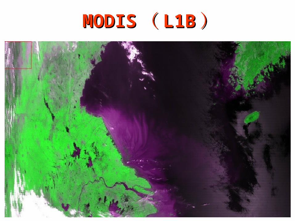
MODISMODIS(( L1BL1B ))
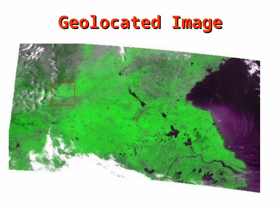
Geolocated ImageGeolocated Image

Results in Google EarthResults in Google Earth

Spatial IntelligenceSpatial Intelligence An Integration of Information, Methodology and Knowledge
supported by Spatial Technology
)(
))((
)(2
n
i
n
j
ij
n
i
n
j
jiij
wS
xxxxw
dI
Information
+ Methodology
+ knowledge
Technology

China Geo-ExplorerChina Geo-ExplorerSpatial Intelligence for Space-Time Data Integration and AnalysisSpatial Intelligence for Space-Time Data Integration and Analysis
Statistics Charts
GIS
Census
Maps
Tables
Reports

Flex W
ebG
IS
Mashup Integration
Geo
Glo
be
Go
og
le Map
WM
S S
erver
WF
S S
erver
Ob
servation
s
Raster Data Time-Series DataVector Data
Statistical D
ataServer
UserO
ther D
ata ….
Data SelectionData Selection ReportsReports MapsMaps ChartsCharts
System ArchitectureSystem Architecture

Primary FunctionsPrimary Functions Data Selection 数据选择 (政府统计、人口普查、经济普查、工业普查、单位普查)
By administrative units (province, city, county, township) By groups By location (X&Y) and spatial range (km or miles) By time-series statistics (province, city and county) By establishments (province, city, county and ZIP)
Reporting 报告 Summary report 汇总报告 Comparison report 比较报告 Original data report 原始数据报表
Spatial Analysis 空间分析 Graphic analysis 图形分析 (直方图, 散点图,多变量图) ESDA spatial statistics 探索性空间统计分析 Spatial Models 空间模型 Gravity Models 重力模型
Export 输出 Data tables (Excel) 数据表格 Reports (Excel, Word, PDF) 分析报告 GIS maps (Shape) 数字地图 Maps (PDF) 打印地图

Selection by Administrative Units Selection by Administrative Units 行政区选择行政区选择
Select by administrative units
Select by map
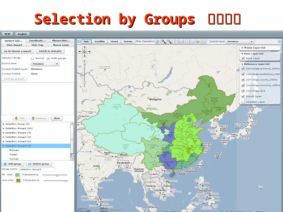
Selection by Groups Selection by Groups 分组选择分组选择

Selection by Locations Selection by Locations 按空间位置选择按空间位置选择
Select by X & Y coordinates
Select by locations on map

Selection by Establishments 单位选择

Province and City Statistics Province and City Statistics 政府统政府统计计

Data SelectionData Selection

Interactive InterfaceInteractive Interface
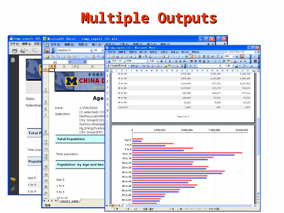
Multiple OutputsMultiple Outputs

Customize ReportsCustomize Reports

Exploratory Spatial Data AnalysisExploratory Spatial Data Analysis

Poyang Lake Monitoring and Decision Support SystemPoyang Lake Monitoring and Decision Support System鄱阳湖水生态监测和决策支持系统鄱阳湖水生态监测和决策支持系统
1999.12
1989.7~4,000km2
~1,000km2

Environmental Challenges with Environmental Challenges with Regional DevelopmentRegional Development

System DesignSystem Design C# + ENVI/IDL + JavaScript

System DemoSystem Demo
登陆界面
系统主界面2011.7.4 水体提取结果2011.7.4 水质综合污染指数2011.7.4 水体透明度2011.7.4 悬浮泥沙浓度

Spatial AssessmentSpatial Assessment• Overlap of water areas with demographic and business data
• Estimates of population and economic units within buffers
2 2 3 4 7
39
96
0
20
40
60
80
100
120
个
股份有限公司
其他有限责任公司
私营独资企业
私营合伙企业
集体企业
其他内资企业
国有企业
直接影响的经济实体数
1 1 1 4 6 10 13 14 26 28 63 122 133 148298
416
759
1170
1594
4722
0
500
1000
1500
2000
2500
3000
3500
4000
4500
5000
( 10km )间接影响的经济实体数 距水边界 以内个
30
52
70
南矶乡
国营江西省恒湖综合垦殖场虚拟乡
莲湖乡
直接影响经济实体的区域分布情况

Future WorkFuture Work
Integration of more data sources Cross-validation and calibration Improvement of detection algorithmsFull Integration with spatial intelligence for
impact assessmentOperational portal for international flood
monitoring

Discussions and SuggestionsDiscussions and Suggestions
Challenges for spatial data sharing Joint initiatives under CODATA