the official ohio lands book
TRANSCRIPT

THE OFFICIALOHIO LANDS BOOK
Written byDr. George W. Knepper

i
Written byDr. George W. Knepper
Cover art by Annette Salrin
THE OFFICIAL
OHIO LANDS BOOK
This book is a publication ofThe Auditor of State
Jim Petro88 East Broad Street
Columbus, Ohio 43216-1140
www.auditor.state.oh.use-mail: [email protected]
First paperback edition 2002
Printed in the United States of America
Ohio Lands 5-30-02.qxd 6/19/2002 4:21 PM Page i

iii
Table of Contents
Auditor’s Message . . . . . . . . . . . . . . . . . . . . . . . . . . . . . . . . . . . . .v
The First Arrivals on Ohio Land
Prehistoric Indians . . . . . . . . . . . . . . . . . . . . . . . . . . . . . . . . .1
Historic Indians of Ohio . . . . . . . . . . . . . . . . . . . . . . . . . . . .2
Congress Creates the Public Domain . . . . . . . . . . . . . . . . . . . . . . .7
Land Ordinance of 1785 . . . . . . . . . . . . . . . . . . . . . . . . . . . . . . . .9
Seven Ranges . . . . . . . . . . . . . . . . . . . . . . . . . . . . . . . . . . . . . . . .10
Northwest Ordinance . . . . . . . . . . . . . . . . . . . . . . . . . . . . . . . . . .13
Statehood for Ohio . . . . . . . . . . . . . . . . . . . . . . . . . . . . . . . . . . . .14
Getting Started as a State
Boundaries of the New State . . . . . . . . . . . . . . . . . . . . . . . .18
Privately Conducted Original Surveys
Virginia Military District . . . . . . . . . . . . . . . . . . . . . . . . . . .19
Connecticut Western Reserve . . . . . . . . . . . . . . . . . . . . . . . .23
Firelands (Sufferers’ Land) . . . . . . . . . . . . . . . . . . . . . . . . .25
Land Sales to Private Groups
Ohio Company of Associates . . . . . . . . . . . . . . . . . . . . . . . .26
Donation Tract . . . . . . . . . . . . . . . . . . . . . . . . . . . . . . . . . . .29
Symmes Purchase (Miami Purchase) . . . . . . . . . . . . . . . . .30
Federal Land Offices and Sales in Ohio
Harrison Land Act, May 10, 1800 . . . . . . . . . . . . . . . . . . . .35
United States Military District (USMD) . . . . . . . . . . . . . . . . . . . .39
Congress Lands
Lands East of the Scioto River . . . . . . . . . . . . . . . . . . . . . . .43
Lands West of the Miami River . . . . . . . . . . . . . . . . . . . . . .43
North of the Seven Ranges . . . . . . . . . . . . . . . . . . . . . . . . .44
Congress Lands in Northwest Ohio
South and East of the First Principal Meridian
and Base Line . . . . . . . . . . . . . . . . . . . . . . . . . . . . . . . . . .45
North and East of the First Principal Meridian
and Base Line . . . . . . . . . . . . . . . . . . . . . . . . . . . . . . . . . .45
Ohio Lands 5-30-02.qxd 6/19/2002 4:21 PM Page iii

iv
Table of Contents
Michigan Survey . . . . . . . . . . . . . . . . . . . . . . . . . . . . . . . . . . . . .46
Federal Land Grants for Specific Purposes.
Moravian Indian Grants . . . . . . . . . . . . . . . . . . . . . . . . . . . .48
French Grants . . . . . . . . . . . . . . . . . . . . . . . . . . . . . . . . . . .49
Refugee Tract . . . . . . . . . . . . . . . . . . . . . . . . . . . . . . . . . . .50
Zane’s Tract . . . . . . . . . . . . . . . . . . . . . . . . . . . . . . . . . . . . .52
Dohrman Grant . . . . . . . . . . . . . . . . . . . . . . . . . . . . . . . . . .53
Other Grants to Individuals . . . . . . . . . . . . . . . . . . . . . . . . .53
Federal Military Reservations
Fort Washington . . . . . . . . . . . . . . . . . . . . . . . . . . . . . . . . .54
Twelve Mile Square Reservation . . . . . . . . . . . . . . . . . . . . .54
Two Mile Square Reservation . . . . . . . . . . . . . . . . . . . . . . .55
Federal Land Grants to the State of Ohio
School Lands . . . . . . . . . . . . . . . . . . . . . . . . . . . . . . . . . . . .56
Ministerial Lands . . . . . . . . . . . . . . . . . . . . . . . . . . . . . . . . .59
Canal Lands . . . . . . . . . . . . . . . . . . . . . . . . . . . . . . . . . . . .61
Wagon Road or Turnpike Lands . . . . . . . . . . . . . . . . . . . . . .63
Salt Reservations . . . . . . . . . . . . . . . . . . . . . . . . . . . . . . . . .65
Swamp Lands . . . . . . . . . . . . . . . . . . . . . . . . . . . . . . . . . . .65
Federal Lands for Higher Education
Ohio University . . . . . . . . . . . . . . . . . . . . . . . . . . . . . . . . . .66
Miami University . . . . . . . . . . . . . . . . . . . . . . . . . . . . . . . .68
Ohio State University . . . . . . . . . . . . . . . . . . . . . . . . . . . . .69
Original Surveys Influence Ohio’s Development . . . . . . . . . . . . .71
Appendix
The Origin of Ohio’s County Names . . . . . . . . . . . . . . . . . .75
Additional Reading . . . . . . . . . . . . . . . . . . . . . . . . . . . . . .79
Ohio Lands 5-30-02.qxd 6/19/2002 4:21 PM Page iv

v
Dear Readers:
As Auditor of State of Ohio, and custodian of state-owned landrecords, I am proud to introduce the newly designed Ohio Lands book.
The book is a short history of original land treaties, grants, surveysand subdivisions used by teachers, historians, genealogists and others.
As part of my official duties, I am responsible for maintaining theinventory and deed records of state-owned real estate.
The office has held this responsibility since 1877, when all of thefederal land surveys, field notes, and tract and entry books concerningOhio were placed in the Auditor’s care. All the instruments which showany right, title or interest in state-owned land, except highways, wererequired to be filed with the Auditor.
All of these records are available either at the Auditor of State’sLand Office or at the State Archives.
The Ohio Lands book is also available in a colorful juvenileversion entitled Along the Ohio Trail. Copies can be obtained by [email protected] or calling 800-282-0370.
This book provides a fascinating glimpse into the development ofOhio. As we prepare to celebrate its bicentennial in 2003, I invite readersto delve into the heritage of this great state I am proud to call home.
Best Regards,
Jim Petro
Auditor of State
Ohio Lands 5-30-02.qxd 6/19/2002 4:21 PM Page v

OHIO LANDSOhio occupies a unique place in the development of the public lands of the
United States. No other state experienced so many different systems of original landsurvey. As the first state formed out of the public domain, Ohio was the social labo-ratory in which Congress worked out not only the basic Federal Rectangular SurveySystem, but also first applied the basic elements for moving a portion of the publicdomain from wilderness to statehood. Central to the statehood-making process wasthe rational system of land division worked out in Ohio, and it is the story of thatdevelopment that we turn to in these pages. In any story about the land, it isimportant to know the people who inhabited it, and so we turn first to Ohio’s earliestinhabitants.
THE FIRST ARRIVALS ON OHIO LAND
Prehistoric IndiansOhio’s first known inhabitants—Paleo-Indian and Archaic People—arrived
more than 12,000 years ago as the great Wisconsinan ice sheet was retreatingnorthward. The Archaic People lived in rock shelters, although recent findings suggestthey may have erected primitive structures. They were nomadic hunter-gatherers. Theyand their successors, for thousands of years, left few cultural remnants beyond stone“points.” The arrival of the Adena people, about 1,000 B.C., marked a higher level ofcultural sophistication. The Adena had a modestly diverse agriculture, built substantialdwellings, traded widely, and made decorative and ceremonial objects. They erectedthousands of small burial mounds and numerous effigy mounds across much of Ohio.
The Hopewell People lived primarily in the southern part of Ohio startingabout 100 B.C. and continuing through several centuries. Their presence over-lapped—to some extent—that of the Adena. The Hopewell had more sophisticatedagriculture, trade, and artisanship than the Adena. They built impressive, geometri-cally shaped mounds, some apparently aligned to heavenly phenomena. About 300A.D., the Hopewell disappeared: no one knows why. They were succeeded by otherprehistoric Indians. The last of the prehistoric groups—the Fort Ancients in thesouth, and the Whittlesey Focus people in the north—fade from view about the endof the seventeenth century.
page 1
Ohio Lands 5-30-02.qxd 6/19/2002 4:21 PM Page 1

Historic Indians of OhioThe historic Indians of Ohio—those we know about from written records—
moved into Ohio in the early and mid-eighteenth century. This is in contrast withneighboring states where historic tribes were established earlier. The late arrival inOhio lands is usually attributed to the fierce Iroquois, who swept westward fromtheir New York villages to devastate lands from Ohio westward. The Iroquoisclaimed sovereignty over the conquered lands and other tribes were not strongenough to challenge them. Therefore, for nearly three-quarters of a century, the Ohiolands were largely uninhabited, creating a social vacuum that ultimately would befilled after 1730 by tribes seeking new hunting grounds. Of the many historic Indiantribes that had some presence in Ohio, only six—Miami, Wyandot, Mingo,Delaware, Shawnee, and Ottawa—maintained more or less permanent villages.From their post in Detroit, French traders and soldiers claimed hegemony over thesetribes during their earliest years in Ohio.
The Miami, whose home villages centered around modern Ft. Wayne,Indiana, established Pickawillany on the headwaters of the Great Miami toencourage British traders. This challenge to French hegemony resulted in the Frenchdestroying Pickawillany in 1752, but the Miami remained important in Ohio Indianaffairs for another half century. The Wyandots, a branch of the Huron people,moved first into Ohio in 1739 and, after many wanderings, settled primarily in theSandusky River Valley and in central Ohio. Ottawas migrated from the overpopu-lated Detroit region to settle along the fringes of northwestern Ohio’s Great BlackSwamp.
The Mingo (a name applied to Iroquois, mainly Senecas, who had driftedwestward from their home fires in New York), built villages in eastern and centralOhio. Delaware (Lenni Lenape), driven from Pennsylvania by both white andIndian pressure, located on or near the Tuscarawas-Muskingum waterway. A specialgroup of Delaware—Christian converts of Moravian missionaries—had short-livedvillages at Schoenbrunn, Gnadenhutten, Salem, Goshen, and Lichtenau in theTuscarawas-Muskingum valley. Shawnees also left Pennsylvania in the mid-eigh-teenth century, and reinforced by fellow tribesmen from other regions, built villagesin the Scioto Valley and later in the upper reaches of the Great Miami.
page 2
Ohio Lands 5-30-02.qxd 6/19/2002 4:21 PM Page 2

Before arriving in Ohio, each tribe had been acculturated in some degreethrough contacts with the French, British, or colonial Americans. Though Francehad long claimed the Ohio country, they erected no posts in what is now the state ofOhio. Ohio lacks the French element in its early history that is common to states toits north and west. Great Britain defeated France in the French and Indian War(1754-63 in North America), took over some French posts in the interior, built someof its own, and dominated the Ohio country until the close of the American
page 3
Moravian missionariesfounded Schoenbrunn(“beautiful spring”) in
1772 as a mission to theDelaware Indians. The
settlement grew toinclude sixty dwellings
and more than 300inhabitants who drew up
Ohio’s first civil codeand built its first
Christian church andschoolhouse.
“The Power of the Gospel” by Christian Schuessle depicts DavidZeisberger, Moravian missionary preaching to the Delaware Indians.
Ohio Lands 5-30-02.qxd 6/19/2002 4:21 PM Page 3

Revolution, largely by supplying the Ohio Indians who were a vital link in thelucrative fur trade.
After assuming control over trans-Appalachian lands, Great Britain tried tomaintain an Indian reserve, especially in the region north and west of the OhioRiver. Back country settlers from Pennsylvania to the Carolinas could not berestrained, however. Led by venturesome men like Daniel Boone, they invaded theKentucky hunting grounds of the Shawnee, while other colonials occupied homesites near the Ohio River in western Virginia. Inevitably aggressive frontiersmentrespassed on Ohio lands, and eastern land companies sent scouts into Indian landsseeking favorable locations in which to plant commercial ventures. In 1774, theShawnee and their Indian allies, led by the Shawnee chief Cornstalk (Holokeska),fought an American colonial army to a draw in the Battle of Point Pleasant, wherethe Kanawha joins the Ohio in modern West Virginia. This was the only majorengagement of Dunmore’s War, a western prelude to the forthcoming AmericanRevolution.
From 1777 to 1782, while colonials battled in the east and south for theirindependence from Britain, a bitter struggle was waged in Ohio between westernsettlers and British-led Ohio Indians supplied from Detroit. This vicious contest isbut poorly known, yet the conflict helped persuade Britain to cede the trans-Appalachian west to the new United States of America in the Peace of Paris (1783).Now Ohio Indians would have to deal with aggressive American settlers and adven-turers unrestrained by British governmental policies. The British lost the war, butthey had not lost their desire to retain the profitable fur trade. To that end, theymaintained their post at Detroit (illegally since it was in U.S. territory) from whichthey supplied Ohio Indians and encouraged them to resist American penetration intotheir hunting grounds.
Administering its new western lands was a priority of the American gov-ernment. First, Indian claims to that land had to be cleared, so U.S. commissionersmet representatives of several Indian tribes at Ft. McIntosh in 1784-85 and con-cluded a treaty that called for restricting most Ohio Indians in a reserve between theCuyahoga and Maumee rivers. Most Ohio lands would now be open for settlement.The United States considered this a valid treaty and proceeded on that assumption.
page 4
Ohio Lands 5-30-02.qxd 6/19/2002 4:21 PM Page 4

The Ohio Indians, especially the Shawnee, refused to abide by a treaty negotiatedunder duress by minor tribal chiefs who lacked authority to speak for their peopleand for other tribes. The Shawnee were even coerced into yet another irregulartreaty at Ft. Finney (1786). Further U.S. efforts did nothing to alleviate the Indians’sense of betrayal, nor their determination to resist with force any attempt by settlersto penetrate their Ohio lands.
While unsettled conditions prevailed, settlers began moving into Ohiolands. These folk, and others exposed along the frontier, were harassed by Indianraiding parties. When it appeared the Ohio Indians and their allies were comingtogether in a loose confederation to oppose settlement, the federal governmentreacted. In 1790, Maj. Gen. Josiah Harmar was sent to punish the Indian confed-eracy. His ill-trained army suffered humiliating defeats by Indian warriors, led bythe Miami war chief Little Turtle (Meshekinoquah) in the vicinity of modern Ft.Wayne, Indiana. The next year, the governor of theNorthwest Territory, Maj. Gen. Arthur St. Clair, trying tosucceed where Harmar had failed, led his army into theworst defeat ever inflicted upon the U.S. Army by Indianwarriors, at a place later called Ft. Recovery. Then, in
Wayne’s men at Fallen Timbers - The original painting, “Charge of the Dragoons at Fallen Timbers?”
by R.F. Zogbaum, ca. 1895. It is part of the Ohio Historical Society’s art collection.
Monument commemoratingthe Battle of Fallen Timbersin 1794. The monument is
located southwest of Maumee, Lucas County, Ohio.
The photograph was taken ca. 1940-1949.
Josiah Harmar(1753-1813)
page 5
Ohio Lands 5-30-02.qxd 6/19/2002 4:21 PM Page 5

1794, Maj. Gen. “Mad” Anthony Wayne led well-trained troops to a convincingvictory at Fallen Timbers. The Ohio Indians, recognizing their inability to stopWayne, met with him to sign the Treaty of Greenville (1795), a treaty theyhonored. It called for a line to separate Indian country from lands now open to set-
tlement. The Greenville Treaty Line confined the Indians to Ohio’snorthwest quadrant and beyond to the north and west. TheLine was laid on the ground by surveyors in 1797, and itbecame a determining feature in the survey and description ofOhio lands.
page 6
Fort Recovery, built in 1792, on the site of Major General Arthur St. Clair’s defeatby an Indian confederacy. Fort Recovery is in Mercer County, Ohio. The
photograph of the reconstructed fort was taken ca. 1940-1949.
Photographic reproduction of a drawing of Fort Greenville, which wasthe headquarters of General Anthony Wayne in his 1793-1796 campaign
against the Confederated Indian Tribes
General “Mad” Anthony Wayne
Ohio Lands 5-30-02.qxd 6/19/2002 4:22 PM Page 6

CONGRESS CREATES THE PUBLIC DOMAINThe War for Independence was still in progress on October 10, 1780,
when the Continental Congress resolved that western lands it might acquire bytreaty with Great Britain or by cession from the states “shall be disposed of forthe common benefit of the United States.” Republican states were to be formedin the ceded land, and they would enjoy “the same rights of sovereignty,freedom, and independence, as the other states.” Great Britain surrendered herclaim to western lands in the Peace of Paris (1783), but several states had claimsbased on their colonial charters. Both Virginia and Connecticut had western landclaims that would affect the future state of Ohio. In 1781, Virginia offered herwestern lands to Congress, which accepted the offer three years later.Connecticut’s cession was accepted in 1786. These state land cessions, plusthose of Massachusetts, paved the way for Congress to establish, in the regionnorth and west of the Ohio River, the first public domain.
The legal matters of ownership having been settled, Congress was stillfaced with the reality of Indian occupancy. The Treaty of Ft. McIntosh (1785)was the first of many treaties between the United States and various Ohio Indiantribes, each treaty releasing additional Indian land to the control of the newnation. Even as Congress sought access to Indian-occupied land, American set-tlers were crossing the Ohio, encroaching on Indian land, carving out smallclearings in the wilderness, providing liquor to Indian peoples, and oftencheating them in trade. These squatters had no legal right to the land theyoccupied, but most were tough, independent, self-righteous, and resistedauthority, so it proved impossible to remove them. Easterners sometimesreferred to them as “banditti,” a favorite put-down of the time.
In 1783, Congress ordered Josiah Harmar, commander of the tinyUnited States army stationed at Pittsburgh, to roust these people from their newhomes and send them back across the Ohio. The army had little success, eventhough resorting to the burning of cabins and fields. Once the army had left andthe ashes cooled, these determined folk rebuilt on Ohio soil. Ft. Harmar, erectedin 1785 at the confluence of the Muskingum and the Ohio, was designed to stemthe flow of squatters, but it, too, proved ineffective.
page 7
Ohio Lands 5-30-02.qxd 6/19/2002 4:22 PM Page 7

Main Treaties Ceding Indian Lands in Ohio
No. Concluded Place oof TTreaty Acres CCeded Tribes CConcerned1 Aug. 3, 1795 Greenville, Ohio 16,930,417 Eleven northwestern
tribes.
2 July 4, 1805 Fort Industry, Ohio 2,726,812 Ottawas, Wyandots,Chippewas,Pottawatamies,Shawnees,Delawares.
3 Nov. 17, 1807 Detroit, Michigan 345,600 Chippewas, Ottawas,Wyandots,Pottawatamies.
4 Nov. 25, 1808 Brownstown, Michigan Two Roads Same tribes as atDetroit,
5 Sept. 29, 1817 Fort Meigs, Ohio 4,554,459 Same as at Fort(Maumee Rapids) Industry, and
Senecas in addition.
6 Sept. 17, 1818 St. Marys, Ohio Ottawas, Shawnees,Wyandots, andSenecas.
7 Oct. 2, 1818 St. Marys, Ohio Weas.
8 Oct. 6, 1818 St. Marys, Ohio 297,600 Miamis.
It was with a sense of urgency, therefore, that Congress considered howbest to develop western lands. It was imperative that the West be governable,preferably by responsible people amenable to legal norms. Congress’ firstattempt was to enact the Ordinance of 1784. Thomas Jefferson was the movingspirit behind this plan to create ten new states north of the Ohio. He proposed thestates be laid out in rectangular form with no consideration of natural boundaries.Before the ordinance was implemented, however, Congress came forward with asuperior plan which initiated many features of a federal land policy.
page 8
Ohio Lands 5-30-02.qxd 6/19/2002 4:22 PM Page 8

THE LAND ORDINANCE OF 1785On May 20, 1785, Congress enacted a land ordinance which became one of
the most significant pieces of legislation ever passed by the federal legislature. TheLand Ordinance of 1785 created rules for the orderly survey, sale, and settlement of thepublic domain, with settlement to occur only on surveyed land. Land ceded by thestates and purchased from the Indians was to be divided into six mile square townshipscreated by lines running north and south intersecting at right angles with east-west lines.Townships were to be arranged in north-south rows called ranges. Most townships wereto be subdivided into 36 one mile square sections. Each range, township, and sectionwas to be numbered in a regular, consistent sequence.
The first north-south line was to be the western boundary of Pennsylvania, andthe first east-west line (called the Geographer’s Line or Base Line) was to begin wherethe Pennsylvania boundary touched the north bank of the Ohio River. TheGeographer’s Line was to extend westward through “the whole territory” which at thattime was meant to include lands lying between the Ohio River and Lake Erie. The firstactual survey extended 42 miles westward, but it did not proceed north of theGeographer’s Line.
The Geographer of the United States was to make a return of the survey aftereach seven ranges had been completed, at which time the Secretary of War was tochoose by lot one seventh of the land to compensate veterans of the Continental army.The rest of the lots were to be sold at auction in New York, then the nation’s capital. Asection (one square mile or 640 acres) was the smallest unit for sale, and some town-ships were to be sold in their entirety. The minimum price was one dollar per acre to bepaid in cash or in land warrants of equivalent value. No land would be sold on credit.
The Ordinance’s other provisions had long term consequences. In eachtownship, section number 16 was to be reserved for the support of public schools. (Thiswas the first federal aid to education, predating the Constitution itself.) Sections number8, 11, 26, and 29 in every township were reserved for future sale by the federal gov-ernment when, it was hoped, they would bring higher prices because of developed landaround them. Congress also reserved one third part of all gold, silver, lead, and coppermines to its own use, a bit of wishful thinking as regards Ohio lands.
page 9
Ohio Lands 5-30-02.qxd 6/19/2002 4:22 PM Page 9

page 10
THE SEVEN RANGESOn the last day of September, 1785, Thomas Hutchins, Geographer of
the United States, and his crew began the first survey of federal land–the SevenRanges in eastern Ohio. As directed in the Ordinance, they pushed theGeographer’s Line 42 miles westward from Pennsylvania. Every six miles theyran lines south to the Ohio River, and within these ranges ran township lines.Using the 1785 numbering system, ranges were numbered westward from thePennsylvania border, townships were numbered south to north within eachrange, and sections were numbered in sequence starting with section 1 locatedin the township’s southeast corner, then running south to north in each tier untilsection 36 was reached in the northwest corner. As directed in the Ordinance,section 16 was reserved for the support of public schools, and sections 8, 11, 26,and 29 set aside for future sale.
In the Land Act of 1796, Congress changed the section numberingsystem. Sections were now to be numbered so that section 1 was located in thetownship’s northeast corner. Numbers would then progress west and east alter-nately through the township “with progressive numbers” until number 36 wasreached in the township’s southeast corner. This system of section numbering
Sections numbered Sections numberedAfter Law of 1796 Before Law of 1796
Ohio Lands 5-30-02.qxd 6/19/2002 4:22 PM Page 10

page 11
The problem of keeping townships six miles square when the earth is
curved was solved in 1804 by Jared Mansfield, Surveyor General of the
Northwest Territory. Mansfield established an arbitrary meridian and
an intersecting east-west base line to survey the 2nd Principal
Meridian in southern Indiana. Ranges of townships were progressively
numbered eastward and westward from the meridian, while townships
within each range were numbered northward and southward from the
base line. This use of the principal meridian and base line can be
found in Northwest Ohio where the Ohio-Indiana line constitutes the
first Principal Meridian and the 41st degree of latitude is the base line.
There are 34 meridians in the United States–some designated by
number, but most by names.
The Seven Ranges
OHIO
Ohio Lands 5-30-02.qxd 6/19/2002 4:22 PM Page 11

page 12
became standard thereafter in all original federal surveys.1 Range, Township,Section, Part of Section, and the original land survey name have become thebasic legal property description for most of the land originally surveyed by theUnited States government in the 29 public land states. The original field notesand plats of the United States government land surveys in Ohio have beendeposited by the Auditor of State into the State of Ohio Archives at the OhioHistorical Center in Columbus.
The Ordinance of July 13, 1787 provided “...there shall be formed in said territory, not less than three nor more than five states...”
The original boundaries were defined as: Eastern State (numbers 1,2,3,4); Middle State (numbers 5,6,7,8,9) and
Western State (numbers 10,11,12,13,14,15). These divisions are marked by broken lines on the map.
Congress later decided to divide the Northwest Territory into the states of: Ohio (1803), Indiana (1816), Illinois (1818), Michigan (1837), Wisconsin (1848), and
Minnesota (1858). These states are shown by the heavy solid lines on the map.
Map Source: Biographical Directory - General Assembly of Ohio 1929-1930: Columbus, 1931.
1) Numbering townships from the Ohio River, and sections according to the 1796standard, was used in these surveys: East of the Scioto River and West of theOhio Company Purchase; North of the Seven Ranges between the United StatesMilitary District and Connecticut Western Reserve; East of the 1stMeridian–West of the Great Miami River and East of the 1st Principal Meridian.
Ohio Lands 5-30-02.qxd 6/19/2002 4:22 PM Page 12

THE NORTHWEST ORDINANCEAs land sales progressed in the Seven Ranges, and as Congress permitted
Virginia and Connecticut to develop their reserves in Ohio, Congress realized it wastime to establish an orderly system of government north and west of the Ohio Riverin what was now designated the Northwest Territory.2 To this end, Congress enactedthe Northwest Ordinance, a remarkable document outlining how a wilderness areawould progress through a three-step process to ultimate statehood. Both northern andsouthern influences were present in the document. Some of Thomas Jefferson’s ideasfrom the Ordinance of 1784 were melded with sections composed in large part byNathan Dane of Massachusetts.
In the first stage of development, the Northwest Territory was to be gov-erned by a governor, a secretary and three judges, each appointed by Congress. Thegovernor and any two of the judges, acting together, could select laws from the codesof the original states. The second stage began when 5,000 free adult males resided inthe Territory. Then eligible voters would elect a legislature, but the governor retainedan absolute veto over its acts. The third stage began when 60,000 inhabitants wereresident in any of the three proposed divisions of the Territory—the eastern, central,or western “states.” At that point the territorial legislature could petition Congress forstatehood. At least three states, but no more than five, were to be erected in theTerritory. Each new state was to be equal to the existing states “in all respects what-soever.” A “bill of rights” guaranteed that basic civil rights would be protected. Trialby jury was guaranteed, as was freedom of religion. Public schooling was to beencouraged. Involuntary servitude—slavery—was prohibited except in punishmentfor crimes for which a person had been duly convicted.
The Northwest Ordinance contained practical steps for achieving statehood,assuring that there would be no second-class states created in the Territory. It enu-merated civil rights essential to a free people. There had never been anything like it inthe history of the world. It is little wonder that scholars rank the Northwest Ordinancewith the Declaration of Independence and the Constitution as a document funda-mental to the emergence of the American republic.
page 13
2) The Northwest Territory ultimately embraced Ohio, Indiana, Illinois,Michigan, Wisconsin and the northeast corner of Minnesota.
Ohio Lands 5-30-02.qxd 6/19/2002 4:22 PM Page 13

STATEHOOD FOR OHIOOhio comprised most of the eastern division, or “state,” in the
Northwest Territory, and was the first part of the public domain to emerge intostatehood. In October, 1787, the Confederation Congress selected its own pres-ident, Arthur St. Clair, to be governor of the Northwest Territory. WinthropSargent was appointed secretary, and three judges were appointed. In thesummer of 1788, Governor St. Clair arrived at Marietta, the first authorized set-tlement in the Northwest Territory, but he soon moved on westward toLosantiville, a struggling settlement that St. Clair renamed Cincinnati. Here he
was more centrallylocated to administer hissprawling charge. Fromthe beginning, St. Clairfaced opposition fromindividualistic settlerswho chafed underappointed rule, and whoset out to expedite thestate-making process.They rushed the countthat found the 5,000free adult males nec-essary to elect a legis-lature. The newlyelected legislaturechafed under the gov-ernor’s veto power, andagain hastened the countto establish the 60,000inhabitants requiredbefore the territorial leg-islature could petition
Photographic reproduction of an engraving of the Chillicothe Courthouse, 1801. The engraving
was published in a periodical, "AmericanPioneer," volume 1, number 6 in June 1842.
View of Front Street in Marietta, Ohio.Shows Thomas Wells and Co. and the
News Depot, ca. 1850-1859.
page 14
Ohio Lands 5-30-02.qxd 6/19/2002 4:22 PM Page 14

Congress for statehood. In their effort to hasten the state-making process, theseleaders in the Northwest Territory found allies in President Thomas Jeffersonand the U.S. Congress.
On April 30, 1802, Congress enacted the Enabling Act whose preambleread, “That the inhabitants of the eastern division of the territory northwest ofthe river Ohio, be, and they are hereby, authorized to form for themselves a con-stitution and State government, and to assume such name as they shall deemproper, and the said State, when formed, shall be admitted into the Union uponthe same footing with the original States in all respects whatsoever.”
Delegates chosen in the eastern division met in a constitutional con-vention in November, 1802 held in Chillicothe, where they drafted a consti-tution for the State of Ohio. Both houses of Congress quickly accepted this con-stitution and forwarded their approval to President Jefferson, who signed the billcreating Ohio on February 19, 1803. The language of the bill seems plainenough; Ohio was a State as of that date. But a host of legalisms muddied thewater to the extent thatOhio’s official birth datewas ultimately set by theOhio General Assembly asMarch 1, 1803, the day thenew legislature met for thefirst time.
The settlement at “the point,” Marietta, ca. 1790
Territorial government is inaugurated, 1788.
Arthur St. ClairGovernor of the
Northwest Territory.
page 15
Ohio Lands 5-30-02.qxd 6/19/2002 4:23 PM Page 15

Critics charge that Ohio was not properly admitted to the Union becauseCongress passed no final joint resolution specifically admitting Ohio. However,both houses of Congress did promptly seat Ohio’s two senators and lone repre-sentative without any caveat about their legality. One hundred and fifty yearslater, during celebration of the State’s sesquicentennial, Congress passed such aresolution (one would hope tongue in cheek) and submitted it to PresidentDwight D. Eisenhower who signed it, thus making Ohio legitimate, retroactiveto 1803.
Ohio was the first state carved out of the public domain, and thereforethe first to be fashioned by Congress. As we shall see, it was in Ohio that
Congress workedout its ultimatesystem of survey—the FederalRectangular SurveySystem. Federal aidto public schoolingwas pioneered inOhio, and slaverywas banned in Ohioas it had been in theNorthwest Territory.Certainly no otherstate has so good aclaim as Ohio to bethe model forwestern devel-opment. It is aproud heritage.
Above: An artist’s drawing of the Capitol Building in Chillicothe when it was Ohio’s first capital city 1803-1810.
Reproduction of a photograph depicting thebuilding that served as Ohio’s capitol building
in Zanesville. Zanesville was the second capital of Ohio from 1810-1812.
page 16
Ohio Lands 5-30-02.qxd 6/19/2002 4:23 PM Page 16

page 17
GETTING STARTED AS A STATEIn 1803, the new State of Ohio was largely a wilderness, and some areas
would remain so until after the Civil War. Only Cincinnati and a half dozensmall communities had much of a presence among its 60,000 plus residents. OnJanuary 11, 1803, Edward Tiffin of Chillicothe was elected governor, but didnot assume office until March. Tiffin had been a leading proponent of statehoodas had many of his influential townsmen, so it was reasonable that Chillicothebecame Ohio’s first capital city. It retained that honor until 1810 whenZanesville wooed away state government by offering a splendid new buildingfor its use. Two years later, Chillicothe provided improved facilities and stategovernment moved back to that town. It was clear, however, that a more centrallocation would better serve a growing state. In 1816, therefore, the legislaturemoved the seat of government to the raw new town of Columbus, where it hassince remained.3
3) The State of Ohio Archives at the Ohio Historical Center has the originaldeed to the ten acre State House grounds.
Photographic reproduction of an engraving of the first state buildingsin Columbus, Ohio, including the United States Courthouse, Public
Offices and the Old State House, ca. 1814 - 1816.
Ohio Lands 5-30-02.qxd 6/19/2002 4:23 PM Page 17

Boundaries of the New StateThe Constitution of 1802 defined Ohio’s boundaries, each portion of which wouldbe challenged by a neighboring state throughout the nineteenth, and well into thetwentieth century. The boundary with Pennsylvania, originally completed in 1785-86 by Thomas Hutchins, was twice resurveyed in the nineteenth century before bothOhio and Pennsylvania were satisfied. All the water of the Ohio River along Ohio’sborder belonged to the earlier established states of Virginia (after 1863, WestVirginia) and Kentucky. Ohio sought to have the state line run through the middle ofthe Ohio River, but it lost every legal effort to secure half of that stream.Meanwhile, damming of the river changed its configuration in the twentieth century,and ultimately federal courts ruled that waters lying beyond the original rivershoreline on the Ohio side belonged to Ohio. Ohio’s border with Indiana was sur-veyed erratically and proved to be inaccurate. Though some corrections were madein the line, both states agreed to leave the boundary essentially as it was. Ohio’snorthern border with Michigan has a dramatic history outlined on page 46. Once theline was finally agreed upon and marked on the land, there remained controversyover the question of why Ohio’s boundary, from its eastern land terminus, should gooff northeasterly to the Canadian border instead of proceeding as a simple extensionof the line marked out on land. Late in the twentieth century, federal courts agreedthat Ohio should retain the disputed portion of Lake Erie.
In the Enabling Act of 1802, federal lands lyingwithin the boundaries of the new state would remainunder federal control. When such land was sold,three-fifths of the money received by the federal gov-ernment was to go to Ohio to be used in constructingroads within the state. The other two fifths was to beused by the federal government to build roads to theOhio boundary. In return, Ohio pledged not to tax federallands within the state for a five year period. Oncefederal land was purchased, of course, the newowner had to pay state taxes on his land.
page 18
Edward Tiffin was chosenspeaker of the territorial house ofrepresentatives. He would go on
to become a Democratic-Republican governor of Ohio
from 1803 until 1807.
Ohio Lands 5-30-02.qxd 6/19/2002 4:23 PM Page 18

PRIVATELY CONDUCTED ORIGINAL SURVEYSTwo major sections of Ohio—the Virginia Military District and the
Connecticut Western Reserve—were surveyed privately, the Virginia MilitaryDistrict under Virginia custom (i.e., indiscriminate claim and metes and boundssurvey), and the Western Reserve in a rectangular pattern chosen by theConnecticut Land Company. These private surveys were underway whileCongress was experimenting with the federal survey system, seeking to create auniform system for the public domain. We will first examine the two privateoriginal surveys, and then follow the evolution of the federal original surveysystem.
Virginia Military DistrictVirginia ceded most of her western lands to Congress in 1781, and
Congress accepted her offer in 1784, including the reserving of approximately4,204,800 acres between the Scioto River to the east and the Little Miami Riverto the west. On the map the area appears as a misshapen triangle with its baseon the Ohio River from which it extends northward some 141 miles. Virginiaintended to use this land to satisfy state military bounty warrants issued as com-pensation to her veterans of the American Revolution.
Virginia Military District, comprisingall or part of 23 counties, is the only Ohioland not originally surveyed on the rectan-gular pattern. Virginia custom was used.Indiscriminate claims were defined by metesand bounds surveys. More than 16,125 suchsurveys were made in the District. The result
was a patchwork ofland holdings thatrelied upon naturalmarkers—trees, pilesof rocks, etc.—forcorner monuments.
page 19
Ohio Lands 5-30-02.qxd 6/19/2002 4:23 PM Page 19

page 20
As markers changed, disappeared, or were disputed, endless confusion resulted,and the Virginia Military District is said to have experienced more litigationover land claims than all the rest of Ohio put together.
Virginia military bounties varied in size from the 100 acres due to aprivate, to the 15,000 acres that could be claimed by a Major General. Theamount increased if the veteran had served more than six years. The heirs of aman killed in service were eligible for his bounty. All told, about 6,146,950acres in Ohio and Kentucky4 were issued under Virginia land warrants to vet-erans and their heirs. There was a brisk trade in land warrants since veterans ortheir heirs could sell them, usually to speculators at a substantially discounted
Virginia compensated its veterans of both the
French and Indian War (1754-63) and the War for
Independence (1775-1783) with western land grants.
Virginia’s most famous veteran, George Washington,
served in both wars and was entitled to 23,333 acres. He
never claimed them: instead, he purchased two warrants,
totaling 3,100 acres, all but 49 of which were within
surveys run in 1787 in Clermont County (two surveys) and
Hamilton County (one survey). An act of Congress (July 17,
1788) nullified these surveys, and Washington never filed
for a U.S. patent under the congressional acts of 1790 and
1794. He mistakenly believed he owned the surveyed land.
These lands were allegedly resurveyed in 1806 and
properly certified to the U.S. Secretary of War. Claim
jumpers occupied the land and secured U.S. patents to it,
thus depriving Washington’s estate of valuable resources.
His heirs were never compensated.
4) Kentucky was part of Virginia until attaining statehood in 1792.
Ohio Lands 5-30-02.qxd 6/19/2002 4:23 PM Page 20

page 21
price. Ultimately some 25 individuals controlled about 1,035,408 acres withinthe Virginia Military District.
From its earliest days, land speculation has been big business inAmerica. Huge estates could also be acquired by surveyors, who took a healthyshare of the land they had laid out as compensation. This form of compensationwas especially common in the Virginia Military District. Among the most suc-cessful at this practice were Nathaniel Massie, who surveyed many of the ear-liest land claims in the region and accumulated some 70,000 acres in theprocess, and Duncan McArthur, later a governor of Ohio, whose holdings
Claiming land by a Virginia Military Warrant involved sending
the warrant to the principal surveyor of the Virginia Military District
in Ohio. He then gave the warrant to a deputy surveyor, who would
make a general description of the claim (entry) and then run a
survey. Virginia permitted a 5% error factor for these surveys, but
this was often exceeded. Following acceptance of the survey, the
warrant was sent to the federal government and a U.S. Patent issued.
For their services, the deputy surveyors often received 20% to 50%
of the acres called for in the warrant, or they could be paid in cash,
which was scarce on the Ohio frontier. In Ohio, the entry number and
survey number are the same.
The first Virginia Military District survey was run by John
O’Bannon, November 13, 1787, in what is now Clermont County. The
first U.S. Patent for District land was issued on February 20, 1796.
The State of Ohio Archives has original Virginia Military District
Entry and Survey records, a card index of entrymen, W.P.A. plats of
16 of the 23 counties involved, and a list of the entries which were
withdrawn. Inquiries can be researched by surname, warrant number,
or survey number. Additional district records can be found at the
University of Illinois Library at Urbana, IL, and the Western Reserve
Historical Society, Cleveland. Soldier’s applications are filed at the
Virginia State Library, Richmond.
Ohio Lands 5-30-02.qxd 6/19/2002 4:23 PM Page 21

exceeded 90,000 acres. Early surveyors often became developers, laying outcommunities and encouraging settlers by offering free lots to first comers. Inthis fashion, Massie developed Manchester (1792), the District’s first real town,and Chillicothe (1796), which soon became the Northwest Territory’s politicalcenter.
By 1830, most of the Virginia Military District’s best land had beenclaimed, but there were still veterans’ warrants in private hands. On May 30,1830, and again on August 31, 1852, Congress passed laws permitting VirginiaMilitary Warrants to be exchanged for land scrip. Land scrip operated as a formof currency and could be used to acquire any U.S. public lands open for entry atprivate sale. The federal government ultimately issued land scrip for 1,041,976acres in exchange for Virginia Military Warrants. On December 9, 1852 Virginiarelinquished, and ceded to the federal government its claim to any unlocatedland in the Military District, and in 1871 Congress ceded this land to the Stateof Ohio. In 1872, Ohio set aside this land as an endowment for the Ohio
page 22
Buckeye Station, second oldest building in Ohio, built by GeneralNathaniel Massie in 1797. It is in Manchester, Adams County, Ohio.
This photograph was taken ca. 1940-1949.NathanielMassie
Ohio Lands 5-30-02.qxd 6/19/2002 4:24 PM Page 22

page 23
Agricultural and Mechanical College (founded 1870). Ohio had previouslyreceived 630,000 acres from Congress to be used for an A&M college under theterms of the Morrill Land Grant College Act of 1862. With this support thecollege grew, and in 1878 was renamed Ohio State University.
Connecticut Western ReserveThe Connecticut Western Reserve includes all or parts of 14 counties in
northeastern Ohio. The Reserve extends 120 miles westward from the Ohio-Pennsylvania line, and is bordered on the south by the 41st parallel of latitudeand on the north by Lake Erie. All of Erie and Huron counties are in theReserve as is the easternmost extension of Ottawa County and the Erie Islands.
Connecticut’s western land claims were based on several royal charters,the most determining of which was the royal charter of 1662 issued by KingCharles II of England. On surrendering its western land claims to the UnitedStates on September 13, 1786, Connecticut retained this reserve, which the stateanticipated would be a New Connecticut in size and influence. It was not to be,however. The Western Reserve contains approximately 3,366,921 acres, or justover 5,260 square miles, including the Firelands, a portion of the Reserve thatwas treated differently from the rest. Connecticut retained jurisdictional controlof the Reserve until surrendering it to the United States by Deed of Cession,May 30, 1800.
Prior to this cession, the State of Connecticut had sold all of the Reserve,except the Firelands, to the Connecticut Land Company by a quitclaim deed to 35investors (many more investors later joined in the enterprise). This sale was com-pleted on September 2, 1795. The Connecticut Land Company paid $1,200,000 tothe State of Connecticut which invested the money in a fund to benefit publicschools in that state. The company investors, whether individuals or groups,pledged money to acquire land from the state. Each individual or group was thegrantee (buyer) of as many 1,200 thousandths, in common and undivided, of thatpart of the Western Reserve as each had subscribed dollars to the purchase price.5
5) The quit claim deed to Moses Cleaveland, who led the first party to surveyand settle in the Reserve, was for 32,600 twelve hundred thousandths.
Ohio Lands 5-30-02.qxd 6/19/2002 4:24 PM Page 23

page 24
In 1796, the Connecticut Land Company, anxious to start land sales,outfitted a survey party, led by General Moses Cleaveland, to run the originalsurvey lines and scout out the region’s resources. The region east of theCuyahoga River was clear of Indian claim as per the Treaty of Ft. McIntosh(1785) as confirmed by the Treaty of Greenville (1795), but to insure that localIndians would pose no problems, Cleaveland met Seneca subchiefs near Buffaloand placated them with trade goods before continuing with his party to themouth of the Cuyahoga. The surveyors could operate only east of the Cuyahoga(which was part of the Greenville Treaty Line) since Indian claims to lands westof the river were still valid, and would remain so, until vacated by the Treaty ofFt. Industry (1805).
The Connecticut Land Company determined upon a rectangular survey.Townships were five miles square except, of course, for partial townships bor-dering Lake Erie. Many townships were subdivided into four lots of 4,000 acreseach. In most cases, however, purchasers subdivided the surveying townshipsinto lots of various sizes and patterns. Ranges were numbered westward fromthe Pennsylvania line, and townships were numbered south to north from the41st parallel.
Much of the Reserve contained poorly drained or inferior soils, so“equalizing” townships were set aside to compensate share owners unluckyenough to draw shares for inferior land. This practice, as well as the method ofdrawing lots, meant that a single purchaser could end up with widely dispersedproperties.
Lots sold slowly in the Reserve. In its early days it was isolated fromaccess to markets. The opening of New York’s Erie Canal in 1825, followed bycompletion of the Ohio and Erie Canal (1825-32) and the Penn-Ohio Canal(1840), greatly relieved that isolation, but in the meantime, sales moved slowlyand eastern land owners were stuck with extensive, unsaleable holdings. Indeed,there was more absentee land ownership in the Reserve than elsewhere in Ohioduring the first quarter of the nineteenth century.
Ohio Lands 5-30-02.qxd 6/19/2002 4:24 PM Page 24

page 25
Ohio Lands 5-30-02.qxd 6/19/2002 4:24 PM Page 25

Firelands (Sufferers’ Lands)On May 10, 1792, the Connecticut state legislature set aside the western-
most 500,000 acres of the Western Reserve to compensate, in proportion to theirloss, the 1,866 Connecticut residents whose property had been damaged by Britishcoastal raiders during the American Revolution. Much property was destroyed byfire (hence the term Firelands), especially in New London where the turncoat,Benedict Arnold, led a devastating raid against his home region.
The Sufferers, their heirs or legal representatives, formed an Ohio corpo-ration on April 15, 1803 to manage their Ohio lands. With Indian claims havingbeen reduced in 1805, the corporation’s Board of Directors authorized a survey. All500,000 acres were surveyed into five mile square townships which were furthersubdivided into four quarter townships each containing 4,000 acres. The sufferers’proprietary rights were divided into 120 classes, each of which represented 120th ofthe total property loss. Then, by a complicated process, lots were drawn assigningthe 120 classes to surveyed property. Sufferers with claims in more than one of the120 classes found their lands dispersed and difficult to manage. By the time detailsof this complex plan were worked out, many original sufferers had died, or were tooold to take up lands in Ohio.
The Firelands are located in Erie andHuron counties, whose western boundarieshave a westering of 4' 40" from the truemeridian so that a constant 120 mile distancewest of the Pennsylvania line could be main-tained. RugglesTownship inAshland County,and DanburyTownship inOttawa County arealso within theFirelands.
page 26
FireLands
Ohio Lands 5-30-02.qxd 6/19/2002 4:24 PM Page 26

LAND SALES TO PRIVATE GROUPSEven as the Confederation Congress was negotiating with Virginia and
Connecticut as to their reserved lands in Ohio, it was involved with speculativeventures led by men from Massachusetts and New Jersey. In two instances,Congress sold Ohio land to private groups, whose settlements were to addanother distinct element to the complex pattern of original surveys.
Ohio Company of Associates In 1783, General Rufus Putnam led fellow officers, veterans of the
American Revolution, in petitioning Congress to pay for their services to thenation with western land grants. When Congress failed to act, Putnam andfellow Massachusetts officers met at Boston’s Bunch of Grapes tavern on March1, 1786, and formed the Ohio Company of Associates to pursue this program.The company was capitalized at $1,000,000 in Continental Certificates, themoney to be raised by selling 1,000 shares at $1,000 per share. Congress wasthen approached for a western land grant, but it showed little interest. Skillfullobbying led by Manasseh Cutler helped congressmen to see the advantages ofhaving a corps of solid citizens setting up communities in the westernwilderness. The military experience of the associates would help to keep theIndians in check, and to protect the new settlements. Congress, therefore, agreedto sell 1,500,000 acres of Ohio lands lying west of the Seven Ranges, north ofthe Ohio River, east of the 16th range (not yet surveyed), and extending as farnorth as required to secure that acreage.
This land was to be privately surveyed on the pattern established by theLand Ordinance of 1785. In each six mile square township, section 16 was to bereserved for support of public schools, section 29 to support religion, sections,8, 11, and 26 for later disposition by Congress, and two entiresurveying townships (72 square miles) in perpetuity forsupport of a university.
Since the land was paid for inseverely depreciated Continental securities,its price was actually about twelve and a halfcents per acre. In allowing payment in depreciated secu-
page 27
Ohio Lands 5-30-02.qxd 6/19/2002 4:24 PM Page 27

page 28
Dividing Ohio Company land into shares was extremely
complex as indicated in this chart. The allotment deeds show seven
separate tracts, grouped in six divisions, were conveyed for each
share as follows:
DDiivviissiioonn TTrraacctt AAccrreess
First One eight acre lot 8.00
Second One three acre lot 3.00
Third One house lot of (about) .37
Fourth One one hundred and sixty acre lot 160.00
Fifth One one hundred acre lot 100.00One six hundred and forty acre lot or section 640.00
Sixth One two hundred and sixty two acre lot or fraction 262.00
TToottaall 11,,117733..3377
rities, Congress undercut its own recent rule, embraced in the Land Ordinance of1785, that land must be paid for in cash or its equivalent. When the Ohio Companycould not meet its second payment, it settled for the 750,000 acres it had paid for.
This is called the Ohio Company First Purchase, and a U.S. Patentfor this land was issued May 10, 1792 by President George
Exterior view of the Rufus Putnam Residence inMarietta, Ohio, ca. 1895. It was one of the dwellingsin Campus Martius, the fortification erected by the
Ohio Company, ca. 1790-1799.
Reproduction of aportrait of General
Rufus Putnam (profile),ca. 1780-1789. He wasa Revolutionary War
veteran and member ofthe Ohio Company who
helped to foundMarietta, Ohio andopen the Northwest
Territory for settlement.
Ohio Lands 5-30-02.qxd 6/19/2002 4:24 PM Page 28

page 29
Washington.6 The First Purchase ultimately contained 913,883 acres includingthe reserved sections and townships.
A congressional resolution of July 23, 1787, permitted military bountywarrants to be used in acquiring Ohio Company land. Such warrants, totaling142,900 acres, were used in acquiring the Ohio Company Second Purchase
totaling 214,285 acres. The U.S.Patent for the second purchasewas also issued on May 10,1792.
The Ohio Company divided964,285 acres it had acquiredinto 822 shares of 1,173.37acres each. On February 1,1796, a deed of partition orallotment was made to 817shareholders. The remainderwas held in trust for thecompany. All lands not previ-ously conveyed or disposed ofwere sold in 1849.
The initial survey of OhioCompany lands began with theadvance party of settlers, whoarrived at Marietta in April,1788. On the east bank of theMuskingum across from Ft.Harmar, a town featuring in-lotsand out-lots was laid out. RufusPutnam directed the initial
6) Under the new Constitution, which took effect in 1789, the nation’s adminis-trative business, formerly conducted by congressional boards, was conductedby the executive branch through various agencies, boards, and offices.
Photograph of the Marietta LandOffice building.
Exterior view of the Ohio Company Land Officein Marietta, Ohio, ca. 1895. It was built after theOhio Company landed at Marietta in 1788. This
photograph depicts the building in its secondlocation. In 1791 the Land Office was moved450 feet east of its original location so that it
could be protected by the guns at CampusMartius from attacks by Native Americanshostile to Anglo-American settlement of the
Ohio Valley. It is the oldest building in Ohio and presently part of the
Campus Martius State Memorial.
Ohio Lands 5-30-02.qxd 6/19/2002 4:24 PM Page 29

page 30
survey under terms of the Land Ordinance of 1785, using its range, township,and section numbering system. Some sections were divided differently toaccommodate the allotment plan.
Ohio Company records are in the Marietta College Library, Marietta,Ohio. Copies of plats showing the allotments and original proprietors are in theState of Ohio Archives in the Ohio Historical Center.
Donation TractThe Donation Tract of 100,000 acres, located along the northern
border of the Ohio Company lands, wasauthorized by Congress on April 21, 1792, tocreate a buffer zone sheltering Ohio Companylands from Indian incursions. To this end, a100-acre lot would be given to any male,eighteen or older, who would actually settleon the land at the time the deed was con-veyed. The 100,000 acres, located in presentAdams, Fearing, Salem, Muskingum, Palmer,Waterford, and Watertown townships inWashington County, and in WindsorTownship, Morgan County, were originallysurveyed into 100-acre lots allotted by agentsof the Ohio Company. On May 10, 1792 theU.S. Patent for the land was issued to theOhio Company which then issued deeds to theactual settlers. In 1818, lands not conveyed reverted to the federal governmentand were sold at the Marietta Land Office.
This marked the first time that federal land was given without charge tospecified settlers, predating the more famous Homestead Act of 1862 by seventyyears. Whether or not the tract actually served as a buffer can not be deter-mined, but it is true that the Ohio Company lands never experienced anotherIndian raid to compare with the Big Bottom Massacre of 1791.
Memorial to the Big BottomMassacre, the January 2, 1791battle between Ohio Company
settlers and the WyandotIndians. The memorial is
located in Morgan County,Ohio. The photograph was
taken ca. 1940-1949.
Ohio Lands 5-30-02.qxd 6/19/2002 4:24 PM Page 30

Symmes Purchase (Miami Purchase) The Ohio Company of Associates was not the only group petitioning the
Confederation Congress for western lands. New Jersey interests, led by Judge JohnCleves Symmes, a member of Congress, persuaded that body in 1787 to sell1,000,000 acres lying north of the Ohio River between the two Miami rivers.Symmes had been attracted to this land by the recommendation of Benjamin Stites,a soldier and trader to whom Symmes granted land near the Little Miami. Stitesand company erected some huts and called their settlement Columbia. It laterbecame an eastern extension of Cincinnati.
Symmes never paid for nor developed the full 1,000,000 acres he sought.He mishandled survey and sales to such an extent that Congress restricted his pur-chase to 311,682 acres, including lands reserved for special purposes. On occasion,Symmes had sold land lying outside the bounds of his purchase. Sometimes hisassociates back in New Jersey sold lots, inadvertently, that Symmes had alreadysold to others, and the reverse was true as well. Symmes ignored repeated federalrequests to set aside the full surveying township he was obligated to supply forsupport of an academy. This confusion was amplified by Indian wars thatdeveloped as the U.S. Army attempted to quell threatsfrom an Indian confederacy through a series of cam-paigns against the tribes in the early 1790s.
On September 30, 1794, President GeorgeWashington signed the U.S. Patent deeding toSymmes 248,250 acres, plus a surveyingtownship to be held in trust for an academy. Aswith the Ohio Company purchase, section 16 ineach township was reserved for the support of
page 31
Ohio Lands 5-30-02.qxd 6/19/2002 4:24 PM Page 31

public schools, section 29 for ministerial lands in support of churches, and sec-tions 8, 11, and 26 for the future use of the federal government. In addition, thepatent reserved 15 acres for Ft. Washington, erected in 1789 and used thereafteras a staging post for the U.S. Army in its attacks against the Ohio Indian con-federacy (1790-94). One square mile near the mouth of the Great Miami wasalso reserved for military purposes.
Symmes paid $70,455 in public securities to acquire 105,683 acres, andused military land warrants totaling 92,250 acres for an additional 142,857acres. Depreciation of securities, plus a federal allowance of one-third dollar offfor bad land and incidental charges, meant that Symmes actually paid abouttwo-thirds of a dollar per acre. As with the Ohio Company, private purchasersbenefited from a better price than Congress offered through regular sales atfederal land offices.
Symmes conveyed the entire third range in trust to his close associate,Jonathan Dayton of New Jersey, because Dayton had purchased military bountywarrants from veterans who neededcash to buy land located outside theSymmes Purchase. This third range isoften called the Military Range in therecords of Warren and Butler counties.
The Symmes Purchase was pri-vately surveyed. It is the only originalland survey in the United States thathas ranges running south to north, andfractional townships running west toeast. Sections are numbered accordingto the Land Ordinance of 1785. Northof the Symmes Purchase, the federal“Between the Miamis Survey” con-tinued the unorthodox numberingsystem in order to maintain consistencywith the Symmes numbering.
Captain John Cleves Symmes Memorial,Hamilton, Butler County, Ohio. Symmes,
son of the original proprietor, was acaptain in the War of 1812, an educator,surveyor, and a philosopher responsible
for the Theory of Concentric Spheres and Polar Voids. This monument was erected in the 1840s and the
photograph was taken ca. 1940-1949.
page 32
Ohio Lands 5-30-02.qxd 6/19/2002 4:24 PM Page 32

Cabin raisings were often community efforts.Ohio Historical Society
Surveyor Christopher Gist is depicted in oneof the 18 original art renderings by Annette
Salrin for the official Ohio Bicentennial of theAmerican Revolution celebration calendar.
Ohio Historical Society
page 33
Persons who unwittingly purchased land which Symmes sold beyond thelimits of his patent, and who settled on that land, were technically squatters onfederal land. Congress corrected this problem through relief acts, passed March 2,1799 and March 3, 1801, giving these settlers pre-emption rights, the first right tobuy their land from the federal government, in most cases at a favorable rate.
Pre-emption rights were of exceptional interest to western settlers. Thesecongressional acts set a precedent that was extended in future land legislation, pre-dating by four decades the Pre-emption Act of 1841 which was more general in
character.Unfortunately,pre-emption,like home-steading, wassubject to fraudand to illegalsettlement onpublic landsnot yet sur-veyed. A view designed to give easterners a look at a
“western clearing” from Ladies Repository, vol. XV (1855); Ohio Historical Society
Ohio Lands 5-30-02.qxd 6/19/2002 4:25 PM Page 33

page 34
FEDERAL LAND OFFICES AND SALES IN OHIO
Determining the price of federal land and the conditions under which itcould be sold was a feature of the land ordinances of 1785 and 1796. In eachcase, the minimum amount one could purchase directly from the federal gov-ernment was set at one full section (640 acres), and the minimum price (landswere sold at auction) was set at one dollar per acre in 1785, and two dollars peracre in 1796. Payment was to be in cash or in debt certificates the equivalent ofcash. In 1785, there was no credit provision: in 1796, one half the purchaseprice was due at the time of sale, and the other half within a year.7
Obviously Congress expected initial purchasers to be from the moniedclass, for $640 plus fees, in cash, was well beyond what the typical settler couldpay. The sale of large amounts of land, with payment in cash, promised to bringmoney into the federal treasury more expeditiously than the sale of many smallamounts to a large number of individual purchasers. Although these lawsfavored speculators, once the speculator possessed land, he normally expectedto sell it to settlers in smaller, affordable parcels. If he could not, he faced a losson his investment. Purchasers at federal land offices sometimes banded together,spreading their resources beyond the purchase of a single section, and sharingresponsibility for potential losses.
The history of federal land policy is replete with efforts to balance theinterests of the federal government with the interests of land-seeking settlers onthe one hand and speculators on the other. The federal government wanted tomaximize income from sales, the settler wanted cheap land under favorableterms. To this end, settlers pressured their congressmen to keep federal land
7) The Confederation Congress (1781-89) and Congress under the new consti-tution (1789-) relied on income from land sales for a substantial part of therevenue needed to operate the government and maintain the military. Thenew nation had but recently fought against what its people consideredexcessive and unfair taxation: it was prudent for legislators to seek non-taxsources of revenue, hence their eagerness to optimize income from the sale ofpublic lands.
Ohio Lands 5-30-02.qxd 6/19/2002 4:25 PM Page 34

page 35
prices low and terms of payment easy. Speculators, having purchased land theyexpected to resell, lobbied to keep prices high enough that they could sell underthe federal price and still turn a profit. The sale terms that evolved under thesecountervailing forces represented compromise. Each party hoped to find newterms of sale that redounded to its benefit. An example of this can be found inthe Land Act passed by Congress in 1800, and known as the Harrison Land Actfor its sponsor.
The State of Ohio Archives has a card index of about
175,000 cards, some of them duplicates, arranged by surname,
and then the given name of the purchaser (entryman) who
acquired federal public lands in Ohio. It also has the Federal
Tract and Entry books which are arranged by surveying
range, township, section, and part of section. These give the
name of the purchaser (entryman), quantity of acres entered,
and date of entry. Sometimes additional information is given,
such as the purchase price, state or country of residence at
the time of entry, the final certificate number, and the federal
land office where the land was sold. The current county and
civil township are not given in the tract and entry books, but
can be determined by using the range, township, section, part
of section, and original survey name, with a map showing
Ohio’s original land subdivisions.
In the year 2000, original land deed records were
electronically imaged and are available in the State Auditor's
Office Legal Division. The State Auditor's Office has more
than 300 cubic feet of original land records in the State of
Ohio Archives. Inquiries should be sent to either the State of
Ohio Archives: Ohio Historical Center, 1982 Velma Avenue,
Columbus, OH 43211 or State Auditor's Office, Legal Division,
88 East Broad Street - 5th floor, Columbus, OH 43215.
Ohio Lands 5-30-02.qxd 6/19/2002 4:25 PM Page 35

Harrison Land Act, May 10, 1800 William Henry Harrison was the sole representative to Congress from
the Northwest Territory. He was associated politically with the group pressingfor early statehood for Ohio. He was born into privilege, but as a frontier res-ident, he was familiar with the liberal land policies desired by actual settlers onwestern lands. The land act that he sponsored represented a compromise ofsorts. It liberalized sale terms while retaining a substantial price per acre.
The Land Act of 1800 established federal land offices in Steubenville,Marietta, Chillicothe, and Cincinnati. Land office business was now morereadily accessible to potential purchasers. The new law provided for sale atauction, and the minimum price was set at two dollars per acre. Private entrywas permitted if the auctioned land did not sell. The minimum amount to besold was cut in half, to 320 acres (half section). For the first time, the lawextended credit to purchasers. The entryman (purchaser) had to deposit 5% ofthe purchase price, including surveying fees, on the day of sale. Another 20%was due within 40 days. Additional payments of 25% of the purchase price were
page 36
Bird's eye view of Steubenville, Jefferson County, Ohio, ca. 1940-1949.
Ohio Lands 5-30-02.qxd 6/19/2002 4:25 PM Page 36

page 37
to be made within two, three, and four years after date of sale. The last threepayments carried an interest charge of 6%. Any tract not completely paid forwithin one year after the date of the last payment would be advertised for saleby the registrar of the land office, who would then sell it at public sale for noless than the whole arrears due. If the land was not sold, or the arrears paid, itwould then revert to the United States. A discount of 8% per year was allowedfor prepayment of any of the last three payments. A purchaser who paid in fullfor his tract on the day of sale could thus buy $2 an acre land for $1.64 an acre.
The act also created two positions—Receiver of Public Monies, andRegistrar of Public Lands. These officials in each land office could permit theSurveyor General of the United States to lease the reserved sections of town-ships for up to seven years on condition that the lessee make improvements. Theact provided pre-emption rights for anyone erecting a grist mill.
The first federal land office opened in Steubenville in July, 1800. Thisoffice and its sister offices in Ohio enjoyed brisk sales that disposed of 398,647acres at a price of $834,888 in the 1800-01 season alone. By June 30, 1820, thefour Ohio land offices had sold 8,848,152 acres (13,825 square miles) for$17,226,186 at an average price per acre of $1.95.
These figures appear to show that federal land was moving at a healthypace, but there were problems. More than 29% of those acres were resold due todefault on payment. The first large scale default was related to the Panic of1819, which was caused in large part by over-extension of credit in public landsales. Land purchasers were often wildly optimistic about their ability to meetpayments. Too many actual settlers, who should have used their funds toimprove land they already owned, took a flyer and purchased additional landbeyond their ability to pay.
Ohio was still a wilderness in 1820. Only a few towns of respectablesize, nearly all of them along rivers in the state’s southern reaches, challengedthe great forests and soggy plains. Even the most favorably located farmersrisked a year’s work as they sent their goods by flatboat down the Ohio-Mississippi riverway to market at New Orleans. Those living in Ohio’s interiorhad scarcely any way to market their crops and livestock. Cash money (specie)
Ohio Lands 5-30-02.qxd 6/19/2002 4:25 PM Page 37

was extremely scarce: much business was carried on by barter. But one couldnot barter with the federal land office. It is little wonder there were frequentdefaults on land payments.
Every interest suffered during the Panic of 1819, not just farmers. Landspeculators, banks and other lenders, and business interests generally, even thosein the eastern states, felt its effects. So there was support for the new Land Act,passed by Congress April 24, 1820, that abolished the credit system. To offsetthis loss of maneuvering room, the price of public land was reduced to $1.25per acre and the minimum purchase reduced to 80 acres. Sales continued, as theeconomy recovered, and the Chillicothe land office alone, from 1820 until itsclosing in 1876, managed 94,182 entries.
The purchase of federal land was a bureaucratic process in the earlynineteenth century. Once a purchaser (entryman) paid for his land, the registrarof the land office issued a final certificate (or certificate of location if land scripwas used in the purchase). The final certificate was then sent to federal author-
ities in Washington D.C. and a U.S. Patent wasissued. Accounts and records had to be verified,
thus extending the process. Until March 1833,each U.S. Patent was signed by thePresident of the United States. The patentwas then returned to the originating land
office to be delivered to the owner (pat-entee). Some patentees failed to record their
U.S. Patents, and others never even pickedthem up from the land office. At the time ofits closure in 1876, the Chillicothe landoffice held thousands of unclaimed patents.These were returned to the General LandOffice in Washington D.C.
page 38
In 1800, William Henry Harrison, served as secretary to
the Northwest Territory. He would go on to become the 9th President
of the United States (March 4, 1841 to April 4, 1841).
Ohio Lands 5-30-02.qxd 6/19/2002 4:25 PM Page 38

page 39
AN ORIGINAL FEDERAL SURVEY ON THE FIVE MILE SQUARE PATTERN
From the story of original surveys in Ohio to this point, it is evident thatCongress was willing to allow a variety of practices. Congress was not beyondexperimenting with their own six mile square township pattern, and in 1796 theydid so. Only the Connecticut Western Reserve, privately surveyed, used the fivemile square, and that survey was going on even as Congress established its ownfive mile square survey to accommodate soldiers’ bounty land warrants.
United States Military District (USMD)As early as 1776, and again in 1780, the Continental Congress had
resolved to grant bounty lands to officers and men of the Continental Line. Eachstate was responsible for seeing to the needs of soldiers in its own regiments.The new Congress under the Articles of Confederation (1781-89) had initiallyprovided bounty lands for Continental soldiers in the Seven Ranges, but thisprovision did not succeed in meeting the need.
On June 1, 1796, Congress addressed the issue again, passing legis-lation that created the United States Military District, sometimes referred to asthe USMD Lands or the USMD Survey.
Survey of the USMD began in March1797 according to the provisions of the act ofJune 1, 1796. The land was to be divided intosurveying townships five miles square(16,000 acres) with the township then dividedinto quarter townships of 4,000 acres each.Ranges were numbered east to west, startingat the line of range seven in the SevenRanges. Townships were numberednorthward from the base line, which is thesouth line of the USMD tract. Quarter town-ships were numbered in a counterclockwisedirection starting with the number one in the
Bounty Land Warrantsfor Veterans of the
American RevolutionAcreage by Rank*
Major General . . .1100 acresBrigadier . . . . . . . .850 acresColonel . . . . . . . . .500 acresLieutenant Colonel .450 acresMajor . . . . . . . . . . .400 acresCaptain . . . . . . . . .300 acresLieutenant . . . . . . .200 acresEnsign . . . . . . . . . .150 acresNon-Commissioned 100 acresSoldier . . . . . . . . . .100 acresSurgeon . . . . . . . .400 acresSurgeon’s Mate . . .300 acres
*Source: William Donohue Ellis, TheOrdinance of 1787: The Nation Begins,Dayton, Ohio: Landfall Press, 1987, p. 28
Ohio Lands 5-30-02.qxd 6/19/2002 4:25 PM Page 39

page 40
Refugee Tract
township’s northeast corner. The quarter townships were subdivided by theiroriginal proprietors in whatever manner they wanted.
One wonders why the original survey conformed so poorly to the actualsize of veterans’ warrants. One explanation, it would seem, must center aroundCongress’ desire for speed in reconciling the veteran pay issue, and the practicalproblems of subdividing the land on a finer grid. Veterans had to pool their war-
Ohio Lands 5-30-02.qxd 6/19/2002 4:25 PM Page 40

page 41
rants if they were to buy from the government. Apparently Congress recognizedthe awkwardness of these conditions and, in 1800, allowed 50 quarter townshipsand fractional quarter townships, not already taken, to be divided into 100 acrelots. Two years later, Congress permitted some fractional townships to bedivided into 50 acre lots. On March 3, 1803, all remaining land not covered bywarrants, or previously subdivided, were to be surveyed into one mile squaresections and sold on the same terms as other public lands.
In the USMD, as elsewhere in the surveyed lands, many veterans soldtheir warrants to speculators or jobbers at a fraction of their true value. Of the1,043,460 acres claimed by land warrant, 569,542 acres were patented to just 22persons. The actual location of the 262 quarter townships claimed by militarywarrants was determined by a drawing. Few absentee owners ever visited theirland, and fewer still spent any time on it. They sold it, sight unseen, as a specu-lative venture, often paying no regard to any attachment of sale made by Ohioofficials for delinquent taxes.
By 1823, the United States government had issued 10,958 war-
rants for service in the Revolutionary War totaling 1,549,350 acres,
and more were issued under various laws thereafter. These warrants
could only be used in the USMD except for those used in the Ohio
Company lands or in the Symmes Purchase. Veterans who held on to
their warrants finally received relief by the act of May 30, 1830, which
allowed them to exchange their warrants for land scrip issued in 80
acre amounts, good for $1.25 an acre on land anywhere in the public
domain available for private entry. This act, plus seven other warrant
exchange acts, caused more than 12,138,840 acres of land scrip to be
issued. Researchers will find that land scrip could be bought cheaply,
depending on market conditions. Its use in land transactions does not
infer the holder was entitled to it by military service. Veterans often
sold their land scrip to land jobbers, thus producing a dead-end situ-
ation for family researchers.
Ohio Lands 5-30-02.qxd 6/19/2002 4:25 PM Page 41

page 42
TERMS OF SALE UNDER VARIOUS U.S. LAND ACTS 1785-1862*
MMiinniimmuummYear Minimum PPrice Terms Purchase
1785 $1.00 per acre Specie, loan-office or debt certificates. 640 Acres
1796 $2.00 per acre One-half down, one half due in one year 640 Acres
1800 $2.00 per acre One-quarter cash, remainder to be paid in 320 Acresthree annual installments.
1804 $2.00 per acre One-quarter cash, remainder to be paid in 160 Acresthree annual installments.
1820 1.25 per acre Cash. 80 Acres
1830 Land Scrip acceptable in lieu of cash
1832 $1.25 per acre Cash, Land Scrip. 40 Acres
1841 $1.25 per acre Squatters who built homes and improved 160 Acresland could purchase one-quarter section before it was offered for public sale.
1855 $1.00 per acre Land not sold for 10 years to be offered at 40-320 Acres$1.00 per acre; if not sold for 30 years, landcould be disposed of at 121/2¢ per Acre.
1862 $10 (filing fee) Title could be obtained after 5 years 160 Acresresidence under Homestead Act.
*1800-1862 Initial Sale by Public Auction
The USMD is bounded on the north by the Greenville Treaty Line, on theeast by the Seven Ranges, on the south by the Refugee Tract andCongress Lands, and on the west by the Scioto River. Its 2,560,000 acres(4,000 square miles) are located in Franklin, Delaware, Knox, Licking,Morrow, Noble, Marion, Holmes, Coshocton, Muskingum, Tuscarawas, andGuernsey counties.
Ohio Lands 5-30-02.qxd 6/19/2002 4:25 PM Page 42

page 43
CONGRESS LANDSInitially all of the public domain could be described as Congress Lands,
but that name was replaced in those regions developed in special surveys suchas the Seven Ranges or the United States Military District. What remained inthe public domain outside these particular regions was still referred to asCongress Lands, and they were surveyed under the federal rectangular system,with six mile square townships, and with the numbering system of 1796.
Lands East of the Scioto RiverThis tract contains more than 3,500,000 acres lying east of the Scioto
River, south of the Refugee Tract and the United States Military District, westof the Seven Ranges, the Donation Tract and the Ohio Company Purchase, andnorth of the Ohio River.
The major portion of this tract was coveted by the Scioto Company, aspeculative venture led by the influential William Duer, which attempted to ridethe coat tails of the Ohio Company to success. The Ohio company did succeed,of course, but mismanagement and fraud doomed the Scioto Company. It wasunable to pay Congress for its purchase and the land remained in the control ofthe federal government.
This survey was integrated into the Ohio Company and Seven Rangessurveys with the six mile square townships numbered south to north and rangesnumbered east to west. A different survey was used in a 25,200 acre tract thatCongress reserved for the French Grants (see page 50). Many irregularities inapplying the national system occur in the East of Scioto Tract due to surveyingerrors, multiple surveys, and erratic numbering.
Lands West of Miami RiverThis tract lies west of the Great Miami River, east of the Ohio-Indiana
state line, and south of the Greenville Treaty Line. The original survey in 1798contained a triangular shaped slice of land, now located in Indiana, thatextended to the Greenville line as it ran from Fort Recovery to opposite themouth of the Kentucky River. The Ohio Enabling Act of 1802 establishedOhio’s western boundary as a surveyor’s meridian, north from the mouth of the
Ohio Lands 5-30-02.qxd 6/19/2002 4:25 PM Page 43

page 44
Great Miami. Ranges are numbered east and west of that meridian, those inOhio being “East of the First Meridian.” Townships are numbered south to northwith irregularities caused in part by the surveyors basing the numbering on theGreat Miami.
North of the Seven Ranges Congress originally expected to include in the original survey of 1785
lands between the Ohio River and Lake Erie. Connecticut’s reservation,accepted by Congress in 1786, preempted lands north of the 41st parallel.Between that parallel and the Base Line of the Seven Ranges Survey, extendingwestward from the Pennsylvania line to the Tuscarawas River, lands were sur-veyed circa 1801 under the law of 1796. The ranges and townships followedthose of the original Seven Ranges, but the sections were numbered accordingto the 1796 pattern.
Land west of the Cuyahoga-Tuscarawas line and north of the U.S. mil-itary District remained Indian territory until that land was ceded in the Treaty ofFt. Industry (1805). The ceded lands lying within the Western Reserve were sur-veyed as an extension of the original Western Reserve survey of 1796-97.Congress Lands south of the Reserve were surveyed in 1806-07. This surveyhad six mile square townships and continued the range, township, and sectionnumbering system of the Ohio River Survey, section numbering being based onthe 1796 land act.
The Signing ofthe Treaty ofGreeneville,
1795, asdepicted by
HowardChandler
Christy (paintedin 1945).
Anthony Waynedictates terms tothe Indians. This
painting iscurrently
hanging in therotunda of the
Ohio Statehouse.
Ohio Lands 5-30-02.qxd 6/19/2002 4:26 PM Page 44

CONGRESS LANDS IN NORTHWEST OHIOLands west of the Ft. Industry line and north of the Greenville line constitute
northwest Ohio, the last major region of the state to be developed. Here lands “guar-anteed” to Indian tribes by the Treaty of Greenville (1795) were relinquished by thetribes in one treaty after another. By 1818, most of northwest Ohio was in possessionof the United States although many small reservations remained until they, too, wereabandoned through forced agreements. After the Wyandots of Upper Sandusky wereforced out in 1842-43, no organized Indian tribe remained in Ohio, and, to this day, itis one of a small handful of states containing no Indian reservation.
South & East of the First Principal Meridian and Base Line In 1817 the Ohio-Indiana border was surveyed and became known as the
First Principal Meridian for all land surveyed in the rest of the United States. The41st parallel of north latitude became the base line. Congress Lands lying east of themeridian and south of the base line were first surveyed in 1819 under the directionof Edward Tiffin, Surveyor General of the United States. The tract included Indianreservations surveyed after the tribes left. This survey used the standard six milesquare township, but townships were numbered north to south. Ranges were num-bered west to east.
North & East of the First Principal Meridian and Base LineThis tract extended eastward from the First Principal Meridian to the
western boundary of the Western Reserve, and northward from the Base Line (41stparallel) to the line then separating Ohio from Michigan Territory. The survey in1820-21 created six mile square townships, numbered south to north, and rangesnumbered west to east. ATwelve Mile Reserve and aTwo Mile Reserve, legacies ofthe Treaty of Greenville, pluscertain lands still held byIndian tribes,were surveyedsome years later.
page 45
Ohio Lands 5-30-02.qxd 6/19/2002 4:26 PM Page 45

The Michigan Survey This original land survey is located in Williams, Fulton, and Lucas
counties. It is a continuation of the federal rectangular surveys starting from theMichigan Meridian, located west of Detroit, and the Base Line located northwestof Detroit. Due to misconceptions about the geography of the region at the timeOhio was going through the state making process, controversy erupted overproper location of the border between Ohio and Michigan Territory.
The controversy traces to the assumption that an east-west line drawnthrough the southern extremity of Lake Michigan, as provided in the NorthwestOrdinance of 1787, would give the “eastern division” (i.e. Ohio) the mouth of theMaumee River, clearly the most desirable feature of the region. This line was con-firmed in the Ohio enabling act of 1802, but shortly thereafter it was discoveredthat Lake Michigan extended further to the south than had been assumed, and aneast-west line from its southern extremity would intersect Lake Erie south of themouth of the Maumee. Armed with this information, delegates to Ohio’s constitu-tional convention wrote into the new state constitution that, with the approval ofCongress, Ohio’s northern border would be a line drawn directly from LakeMichigan’s southern extremity to the “most northerly cape of the Miami(Maumee) Bay.” Congress approved the constitution without either confirming orrejecting Ohio’s self-negotiated line.
In 1817, the Surveyor General of Ohio oversaw a survey by WilliamHarris, who ran a boundary line according to the language of the OhioConstitution. Michigan objected and ordered its own survey, known as the FultonLine, according to boundary descriptions in the Northwest Ordinance and theOhio enabling act of 1802. Land between the Harris Line and the Fulton Line,sometimes called the “Toledo Strip,” was hotly contested. Both Ohio andMichigan Territory threatened to occupy this land with militia, and each madeother gestures by which they hoped to demonstrate control. The issue came to ahead in the mid-1830s as Michigan was preparing for statehood. Both Congressand Andrew Jackson’s presidential administration became involved in the dispute.Ultimately Ohio’s superior political clout prevailed, and on June 15, 1836,Jackson signed a congressional act awarding the disputed region to Ohio.
page 46
Ohio Lands 5-30-02.qxd 6/19/2002 4:26 PM Page 46

page 47
Michigan achieved its main goal, statehood, in 1837 and, as consolation for lossof the “Toledo strip,” was awarded 9,000 square miles which became its UpperPeninsula.
In 1915, Ohio and Michigan joined in a resurvey of the Harris Line that“satisfied” both states. However, where the Harris Line touched Lake Erie’s shore,it was extended northeasterly to the Canadian boundary in Lake Erie, giving Ohiomany square miles of Lake Erie coveted by Michigan, which claimed the HarrisLine should have been extended in a straight line to the boundary. This conflictwas resolved in 1973 when federal courts ruled that the disputed area in Lake Eriebelonged to Ohio.
The Michigan Survey is based on the Michigan Meridian and Base Line.Ranges are numbered from the Meridian in both an east and a west direction.Township numbering is uniquely irregular, but it is based on the line of the 41stparallel.
The survey of Northwest Ohio used the Ohio-Indiana state line as a “First PrincipalMeridian.” The 41st parallel of north latitude
became an intersecting, east-west base line used in surveying.
Ohio Lands 5-30-02.qxd 6/19/2002 4:26 PM Page 47

FEDERAL LAND GRANTS FOR SPECIFIC PURPOSESCongress made federal land grants to groups or individuals for specific
reasons: some in sympathy for a mistreated group, some for services renderedthe United States, and at least one—Zane’s Tract—in fulfillment of a businessarrangement.
Moravian Indian Grants Moravian missionaries came to America in the seventeenth and eigh-
teenth centuries, in part to introduce Christianity to the Indians. In 1772 andshortly thereafter, they brought their Delaware and Mohican converts to theTuscarawas Valley. There they established several villages, but the location wasunfortunate. The villages were situated between hostile, British-supported tribesto their west, and aggressive American frontier fighters to their east during aperiod of bloody struggle in the Ohio country. On March 8, 1782, a band ofabout 100 Pennsylvania militiamen who had suffered atrocities from hostile
page 48
Aerial view of the Moravian Village, Schoenbrunn, in New Philadelphia,Tuscarawas County, Ohio, 1930-1939.
Ohio Lands 5-30-02.qxd 6/19/2002 4:26 PM Page 48

Indians descended upon Gnadenhutten, rounded up the Christian Indians nearby,and systematically murdered 96 men, women, and children.
The slaying of these innocents horrified many easterners, safelyremoved from the crude realities of the frontier. Congress thus made recom-pense in the Land Ordinance of 1785 by granting to the Moravian Indian sur-vivors three tracts of 4,000 acres each, located near Schoenbrunn,Gnadenhutten, and Salem—Moravian towns situated in the Tuscarawas Valley.In an ordinance of September 3, 1788, these tracts were donated in trust to the“Society of the United Brethren (Moravian) for propagating the Gospel amongthe Heathen.” This act was intended to help Moravian missionaries in the taskof “civilizing” the tribes, and was to encourage scattered remnants of theChristian Indian peoples to return to their former homes along the Tuscarawas.
On February 24, 1798, a U.S. Patent was issued to the United Brethrenas trustees for the Indians, but few of the now scattered Christian Indiansreturned to their shadowed valley. Thus, by agreements signed by a U.S.Commissioner, the United Brethren and the Christian Indians, the trust wasrevoked in 1823 and the three tracts transferred to the federal government. TheUnited BrethrenDeed ofRetrocession wasexecuted April 24,1824, and acceptedby Congress May26, 1824.
In 1825,the three tractswere divided intofarm lots and latersold by governmentagents at the court-house in NewPhiladelphia. Lots
page 49
Interior of reconstructed schoolhouse in theMoravian village, Schoenbrunn, in New
Philadelphia, Tuscarawas County, Ohio, 1939.
Ohio Lands 5-30-02.qxd 6/19/2002 4:26 PM Page 49

remaining unsold were later sold at the Zanesville Land Office. The ChristianIndians received a $400 annuity from the sale proceeds, and the United BrethrenSociety received enough money to pay the debt remaining from improvements ithad made to the tracts.
French Grants The French Grants, located along the Ohio River in Scioto County, were
awarded to 101 Frenchmen who had been swindled by the Scioto Company (seepage 43). Unscrupulous agents sold lands the company did not own to credulousFrench emigrés. In the process, they grossly misrepresented what lay in store for
the emigratingFrenchmen. Thelands to which theFrench heldworthless titles wereactually locatedwithin the OhioCompany purchase.The Ohio Companyprovided them initialshelter and then sold
lots to them for $1.25 an acre. Many of the French decided to try their luck else-where, but those who remained founded Gallipolis (city of the Gauls).
Congress was prevailed upon to aid these unfortunates who had paidtwice for land. It passed a bill on May 31, 1795 giving 24,000 acres to “theFrench inhabitants of Gallipolis.” John Gervais received 4,000 of these acres forservices in obtaining the grant. The remainder was surveyed into 92 lots of217.4 acres each. This is commonly called the First Grant. Eight inhabitants ofGallipolis did not receive a portion of the First Grant, so Congress granted anadditional 1,200 acres on June 25, 1798. This land was surveyed into 150-acrelots and is known as the Second Grant.
page 50
Arrival of the French settlers at Gallipolis.
Ohio Lands 5-30-02.qxd 6/19/2002 4:26 PM Page 50

page 51
Refugee Tract The Refugee Tract of 103,527 acres is located in parts of Franklin,
Fairfield, Licking and Perry counties. It extends eastward from the Scioto Riverfor 42 miles along the south line of the United States Military District. In thefirst 30 miles, the Refugee Tract is four and one half miles wide, but it narrowsto three miles wide in its easternmost twelve miles.
The refugees were persons from British Canada who had fled south toaid the colonial cause during the War for Independence. Terms of the grant wererestrictive. On April 7, 1798, Congress granted land to refugees who had fledsouth before July 4, 1776, continued to aid the United States, and who did notreturn to reside in territory ruled by the British monarch prior to November 25,1783. In other words, the refugee had to have been away from home, aiding therevolutionary cause during the entire revolutionary struggle. Not many couldqualify, even though Congress provided that bounty land could be claimed bywidows and heirs of such persons if they died within the United States or incolonial service during the Revolutionary War.
An act of February 18, 1801 established the boundaries of the RefugeeTract and named the claimants and the amount of land to which each wasentitled. Other claimants were named in an act of April 23, 1812. In all, 67claimants received 58,080 acres, most of it in 320, 640, 960, 1280, and 2,240acre amounts.
The Refugee Lands were not set aside until after the regular federalsurveys had progressed to the United States Military District, so range,township, section lines and numbers were already established. Townships werefractional (partial) and were subdivided into 320-acre lots by halving each fullsection with a north-south line. The claimant’s grant was located by drawinglots. An act of April 29, 1816 authorized the Chillicothe Land Office to sell45,447 unclaimed acres.
In Columbus, the Refugee Grant lies approximately between FifthAvenue on the north and Refugee Road on the south. The Ohio Statehouse andmost downtown office buildings are located within the tract.
Ohio Lands 5-30-02.qxd 6/19/2002 4:26 PM Page 51

page 52
Zane’s Tract Ebenezer Zane, an early settler of Wheeling in Western Virginia, con-
tracted with the federal government to build a road through the southern Ohiowilderness. Zane’s Trace, as the road was called, was hacked out of the denseforest in 1796-97. It was little more than an improved bridle path connectingWheeling with Limestone (Maysville), Kentucky, a principal stopover for downriver travelers.
As payment for his work, Congress authorized Zane to locate threetracts of 640 acres each solong as he paid for thesurveys and did not interferewith existing governmentsurveys. Zane located histracts where his trace crossedthe Muskingum, Hocking,and Scioto rivers. He receivedthe right to operate ferries atthese strategic sites. Thewisdom of his choicesbecame apparent as theMuskingum crossing grewinto Zanesville (named forEbenezer), the Hockingcrossing became Lancaster,and Chillicothe developedacross the Scioto from hisother grant.
By an act of April 3,1802, Ebenezer’s brother,Isaac Zane, was granted threesections of 640 acres each, forservices to the federal gov-
Memorial to Isaac Zane & Simon Kenton, Zanesfield,Logan County, Ohio. The memorial was unveiled
September 8, 1914. The photograph is ca. 1940-1949.
Reconstruction of the home of Ebenezer Zane, Jr. inLogan County, Ohio. The home was built in 1805and used as an army headquarters in the War of1812. The photograph was taken ca. 1940-1949.
Ohio Lands 5-30-02.qxd 6/19/2002 4:26 PM Page 52

page 53
ernment as intermediary with the Ohio Indians. Two of the sections were reservedfor the use and benefit of Isaac’s children, living at the time of his death, or theirheirs. Zane was issued a U.S. Patent for these tracts on August 28, 1806. They arelocated in the civil townships of Salem and Concord in Champaign County.
Dohrman Grant Arnold Henry Dohrman—agent for the United States to the Portuguese
crown during the Revolutionary War—fed, clothed, and nursed American sailorscaptured by British cruisers and then released into Dohrman’s hands. His requestfor reimbursement for the funds he personally subscribed in this work were in largepart disallowed by the Treasury for lack of proper documentation. Congress sym-pathized with his plight, however, and on October 1, 1787, granted him an entiretownship (23,040 acres) as compensation for his expenses and in recognition of hishumanitarian efforts.
By an act of February 27, 1801, President John Adams issued a U.S.Patent to Dohrman for Township 13, Range 7 in the Seven Ranges Survey. Today,half of that land lies in Harrison, and half in Tuscarawas counties. On March 3,1817, Congress granted his widow, Rachel, a lifetime annuity of $300, and to eachof Dohrman’s minor children, $100 annually until they reached age 21.
Other Grants to Individuals The Dohrman grant was unusually generous, overshadowing in scope
grants made to many others in Ohio. The United States made small grants to someIndian leaders as part of treaty negotiations, to white men freed from Indian cap-tivity, and to early settlers who traded with the Indians on behalf of the UnitedStates. The lands granted were located in northwestern Ohio, some of them alongthe St. Mary’s River.
Other individuals were rewarded with the grant of pre-emption rights,which was the right to have first opportunity at purchasing federal land withouthaving to bid on it. This advantage was eagerly sought by settlers, and their lob-bying with congress finally paid off in the Land Act of 1841, granting pre-emptionto people settled on federal land that they did not own.
Ohio Lands 5-30-02.qxd 6/19/2002 4:26 PM Page 53

page 54
FEDERAL MILITARY RESERVATIONS (FORTS)Pioneer Ohio had two kinds of fortifications: those that were locally
created, like Marietta’s Campus Martius, and those that were federally man-dated. Federal fort locations (the structure plus surrounding land), often pre-ceded original surveys, and their lands were integrated into the original surveysat a later time. A few federal forts, however, were original surveys.
Fort Washington Fort Washington was built in Cincinnati in 1789 to protect settlers. It
became the staging post for U.S. Army campaigns against the Indian confed-eracy in the 1790s. The military reservation covered 15 acres, and was set asidefor use by the federal government in John Cleves Symmes’ U.S. Patent. Its mil-itary value much diminished, Congress ordered the property subdivided in 1806into town lots and streets which were to conform to the original town plat ofCincinnati. The survey, certified July 8, 1807, shows the fort’s boundaries to beFourth Street to the north, Ludlow Street to the east, the Ohio River to thesouth, and Broadway to the west. Modern Cincinnati’s waterfront attractions arebuilt partly on the old Fort Washington grounds.
Twelve Mile Square Reservation The Treaty of Greenville (1795) reserved to the United States a twelve mile
square military reservation located at the rapids of the Maumee. This strategiclocation had been recognized by the British, who erected Ft. Miami on the north bankin 1794 to assist Ohio Indians to stop further encroachments upon their lands. As acondition of Jay’s Treaty (1794), the British abandoned the fort in the summer of1796. During the War of 1812, General William Henry Harrison’s army erected Ft.Meigs on the south side of the Maumee just below the rapids, but long before that,surveys had been made within the Twelve Mile Square.
By an act of Congress March 3, 1805, the Reserve was surveyed into four,six mile square townships, numbered clockwise with number one located in thesouthwest corner. Each township was partially subdivided into sections althoughmany sections impinged upon private land claims. In 1816, sections fronting the riverwere subdivided into long lots of about 160 acres apiece. They are numbered 1 to 93
Ohio Lands 5-30-02.qxd 6/19/2002 4:26 PM Page 54

page 55
and called “River Tracts” in the State Auditor’s records. Also in 1816, town lots andout lots were to be laid out in a quantity not to exceed two entire sections. Includedwas the town of Perrysburg.
Two Mile Square Reservation The Two Mile Square, now embraced within the city limits of Fremont, was
another strategic location reserved to the United States in the Treaty of Greenville(1795). It was located on both sides of the Sandusky River at the rapids. During theWar of 1812, Americans built Ft.Stephenson on an acre of land onthe river’s west side. In 1813, youngMajor George Croghan and hisbadly outnumbered troops success-fully defended the fort against aBritish and Indian force of about1,300 men.
In 1807, the Two MileSquare was surveyed into four 640-acre sections. By an act of April 26,1816, section one, east of the river,was divided into 310 in-lots and 63out-lots to create the town ofCroghanville, named to honor thedefender of Ft. Stephenson. In 1829,the town, now on both sides of theriver, was incorporated as LowerSandusky. In 1848, however, itsname was changed to Fremont tohonor Maj. Gen. John C. Fremont,the “Pathfinder of the West.” Thefederal land office in Woosterhandled early land sales.
Fort Washington, erected 1789-90 in Cincinnati.
Marker commemorating FortWashington, built in 1789 and 1790 onthe Ohio River, opposite the mouth of
the Licking River. It was demolished in1808. The marker is located in
Cincinnati, Hamilton County, Ohio. Thephotograph was taken ca. 1940-1949.
Ohio Lands 5-30-02.qxd 6/19/2002 4:26 PM Page 55

page 56
FEDERAL LAND GRANTS TO THE STATE OF OHIOIn addition to its grants to groups and individuals, the federal gov-
ernment made substantial land grants to the State of Ohio in support of specificpurposes. These grants involve many interests. The principal ones are describedbriefly herein.
School Lands Among the Founding Fathers’ generation were leaders who believed an
educated public was necessary to sustain a self-governing republic. Even beforeadoption of the Constitution of 1787, the Confederation Congress had providedreal support for public schooling by providing, in the Land Act of 1785, thatsection 16 (one square mile) in every survey township, be set aside for the“maintenance of public schools within said township.”8
The ordinance regards the township as a surveying unit, a six milesquare containing 36 one mile square sections numbered in a prescribedsequence. Section 16 is located close to the center of the township. Civil town-ships, on the other hand, are political units of local government within counties.In states surveyed under the federal rectangular system, survey townships andcivil townships usually have the same boundaries, but there are many excep-tions.
The Northwest Ordinance of 1787 identified characteristics to be foundin a well-ordered, democratic society, but it made no provision, beyond encour-agement, for support of public schooling. In the enabling act of 1802, however,Congress offered three positions which, if accepted by delegates to the 1802constitutional convention, “shall be obligatory upon the United States.” The firstproposition was that section 16 in every township, “and where such section hasbeen sold, granted, or disposed of,” equivalent land closest to section 16, “shallbe granted to the inhabitant of such township for the use of schools.”
Convention delegates responded with a counterproposal. The UnitedStates should donate one thirty-sixth (2.77%) of the land area of Ohio for the
8) By 1920, 73,155,075 acres of public land had been given by the federalgovernment to the public land states in support of public schooling.
Ohio Lands 5-30-02.qxd 6/19/2002 4:26 PM Page 56

page 57
The United States government ulti-
mately granted 704,204 acres to Ohio for
the support of public schooling. Each
township received section 116 whenever pos-
sible, or another section in lieu of it. Early
land grants sometimes interfered with the
availability of section 16, so it was not
uncommon for a substitute section to be
assigned. Downtown Columbus, for
example, is situated in Range 22, Township
5, Section 16 (according to Matthew’s
Survey) which should have been reserved
for support of public schools. However, the Refugee Grant overlapped this
section 16, and it was therefore unavailable for schools, but was available to
claimants of the Refugee Grant. Thus township 5’s schools were assigned
Section 15 in Township 11, Range 21 (Matthew’s Survey), which is located next
to Township 11’s school section, now located in Madison Township, Franklin
County, near Groveport.
The Virginia Military District, the Connecticut Western Reserve, and
the United States Military District all received school lands, but these lands
were not located within either the Virginia Military District or in the Western
Reserve because neither tract was developed under federal jurisdiction.
Virginia Military District school lands (105,600 acres) are located in
Morrow, Wayne, Holmes, Ashland, Richland and Crawford counties.
Western Reserve lands are located in Holmes and Tuscarawas counties
(56,000 acres) and in Williams, Defiance, Paulding, Putnam, Henry, and Van
Wert counties (37,724.16 acres). In all, the Connecticut Western Reserve was
granted 93,724.16 acres.
United States Military District school lands totaled 72,000 acres and
are located in Guernsey, Coshocton, Muskingum, Licking, Morrow, and
Delaware counties. The Donation Tract, the Two Mile Square reserve, the
Moravian Tracts, and the French Grants were granted school lands either
within the tracts, or adjoining them.
Congress reserved section 16 nearthe middle of each township for
the use of public schools.
Ohio Lands 5-30-02.qxd 6/19/2002 4:26 PM Page 57

page 58
9) Miami University became the beneficiary of the grant of a township to supporthigher learning.
support of public schools. Also, the United States should give the state not lessthan three percent of the net proceeds derived from public land sales in Ohio forconstructing roads within the state, and should donate one survey township(23,040 acres) for an institution of higher learning. Finally, the Ohio legislatureshould be given control of the donated lands, in trust, for the purposes Congressintended when making the Grant.9 Congress accepted these bold counterpro-posals on March 3, 1803, thereby appropriating public land to honor its com-mitment to Ohio.
On April 15, 1803, Ohio’s first state legislature provided for leasing andadministering school lands. Initially lands were to be leased for seven to fifteenyears. The lessee was obligated to clear and fence the property, plant 100 appletrees, and perform other duties. In 1817, in what proved to be an unfortunatemove, the legislature allowed school lands to be leased for 99 years, renewableforever. Some legislators wanted to sell school lands, and on February 1, 1826,Congress permitted sales with the provision that the township’s inhabitants mustvote their consent. The legislature complied with this mandate and, on January20, 1827, enacted the voting, appraisal, and conveyance procedures to be fol-lowed. Proceeds from the sale of school lands were to be deposited in theCommon School Fund, and interest on the principal paid to the schools withinthe original surveyed townships.
The Ohio Constitution of 1851 (still the basic law of Ohio, althoughmuch amended) provided in Article VI, Section I for protection of the principalof all funds received from the sale or other disposition of the lands granted orentrusted to the state for educational or religious purposes. This article wasamended in 1968, and the trust monies were then dispersed for educational pur-poses.
Until 1914, school lands were administered by trustees of the originalsurveyed townships. Often their stewardship was sloppy, a problem that wentback to the earliest days of statehood. In 1838, for example, Samuel Lewis, thestate’s first Superintendent of Common Schools, issued the “First Annual Report
Ohio Lands 5-30-02.qxd 6/19/2002 4:26 PM Page 58

page 59
from this department for the State of Ohio.” Lewis rode on horseback overmuch of the state gathering information. His report chronicled abuses bytownship trustees including misdirecting tax monies ostensibly collected forschool purposes, and leasing school lands to favorites under excessively gen-erous terms. Later generations would call the latter abuses “sweetheart deals.”
In 1914, the Auditor of State became responsible for leasing mineralrights on school lands, and in addition to his other duties, the Garver Act of1917 made him Supervisor of School and Ministerial Lands. The Auditorretained supervisory control until August 1, 1985, when the legislature trans-ferred most of these duties to the Director of Administrative Services.10
On June 29, 1988, legislation went into effect that transferred thegeneral charge, supervision, management, and all remaining monies of schoollands from the Director of Administrative Services to the Board of Education ineach school district that had been allotted these lands. Title to them is now heldin trust by the State of Ohio, through the General Assembly, as per a March 3,1803 Act of Congress.
The Auditor of State maintains the record copy of School andMinisterial Land deeds issued by the State of Ohio. Final certificates for suchlands, as well as lease records, are located in the State of Ohio Archives, OhioHistorical Center.
Ministerial Lands In the early years of the American Union, some states still taxed their
citizens for the benefit of religion. This was a holdover from English and otherEuropean traditions where one denomination constituted a state church andreceived its support and other perquisites from the state. In America, however,religious diversity undercut that practice as it became apparent that there wouldbe no agreement on whose religious practices would prevail, let alone earn
10) At the time of transfer, four school land farms totaling 1,232 acres wereunder two year leases, while several small lots in Columbiana County wereunder lease for 99 years, renewable forever. The four school land farms werelocated in Hardin County, Marion Township (R9E, T4S, S16-640 acres);Ross County, Green Townships (R21, T9, S15-312 acres); Marion County,Big Island Township (R14E, T5S, S15-160 acres); and Franklin County,Madison Township (R21, T11, S16-120 acres).
Ohio Lands 5-30-02.qxd 6/19/2002 4:26 PM Page 59

public tax support. Congress’ grant of ministerial lands in Ohio (such grantslimited to the Ohio Company Purchase and the Symmes Purchase) wastherefore somewhat of an anomaly.
Both the Ohio Company’s First Purchase and the Symmes Purchaseprovided that section 29 of each township be set aside for the support ofreligion. Monies realized from the leasing or sale of section 29 were to be dis-tributed to the township’s churches on a pro rata basis according to each denom-ination’s membership. As with school lands, township trustees were in charge ofadministering these lands. After Ohio emerged as a state, the Ohio GeneralAssembly became the trustee of ministerial lands. The legislature enacted lawspermitting 99-year leases, renewable forever. Income from ministerial lands,therefore, was severely limited.
Ohio’s ministerial lands totaled 43,525 acres. In the Ohio CompanyFirst Purchase, ministerial lands were located in Washington, Meigs, Gallia,Lawrence, and Athens counties. When the original survey was made, it was dis-
page 60
Some 99-year leases renewable forever are still in effect in
Marietta and in Hamilton County’s Delhi and Green townships.
Persons occupying these lands do not own them, which presents a
title problem. To clear this problem, persons pay the back rent and
receive a deed from the State of Ohio. The back rent on some parcels
has been as low as five cents a year because the original 1805 rent
formula is still in effect.
In 1833, Congress authorized Ohio to sell ministerial lands.
Money from the sale was invested, and churches within the original
surveying township received the interest and rent money until 1968,
when the constitutionality of such church-state relationships was
challenged. Congress then authorized the remaining ministerial funds
to be dispersed for schools. In May, 1968, Ohio voters approved a
constitutional amendment that directed any future ministerial income
be used solely for educational purposes.
Ohio Lands 5-30-02.qxd 6/19/2002 4:26 PM Page 60

page 61
covered that Marietta was within a ministerial section, and the federal gov-ernment would not permit the sale of section 29 in Marietta. Congress did notset aside section 29 in the Ohio Company’s Second Purchase (parts of Vinton,Morgan, Hocking, and Athens counties), but on January 7, 1796, the OhioCompany set aside section 29 in each of the ten surveying townships located inthis tract. Congress treated section 29 lands in the Symmes Purchase as it didthose in the Ohio Company lands through a contract with the Board of Treasury.Ministerial lands in the Symmes Purchase are located in parts of Hamilton,Butler, and Warren counties.
Ministerial lands are yet another evidence that Ohio’s experience withfederal lands is unique.Congress made no other pro-vision for the support ofreligion elsewhere in the publicdomain. Some small, specificmission grants were made in afew western states based on thehistoric presence there of con-tinuous religious activity.
Canal Lands Canals opened the
interior of Ohio to national andworld markets. In 1825 thestate commenced constructionon the Ohio and Erie Canaland the Miami Canal, laterextended into the Miami andErie Canal. It was an enormousundertaking for a relatively poor state to handle. Ohio followed the lead of NewYork State, which had just completed its Erie Canal, and sold state-backedbonds in eastern money markets to finance construction of these two through
The old Miami and Erie Canal, built between1825-1845, St. Marys, Auglaize County,
Ohio, ca. 1940-1949.
Ohio Lands 5-30-02.qxd 6/19/2002 4:27 PM Page 61

page 62
routes connecting Lake Erie with the Ohio River. Several short feeder lines werealso constructed.
In Ohio’s settled areas, land for canal right-of-way was secured througheminent domain. In some cases, land owners donated right-of-way to the stateknowing that a canal would enhance the value of their remaining holdings. Thenorthward extension of the Miami and Erie, however, ran largely through unsoldfederal lands. In 1828, Congress granted Ohio 500,000 acres in the state’s north-western region to help finance the northward extension of the Miami Canal.This was the first of several grants that ultimately totaled 1,100,361 acres. Ohiorealized $2,257,487 from the sale of these lands.11
Ohio’s canal era was rather brief. Construction started July 4, 1825. ByJuly 4, 1827, the first usable section of the Ohio and Erie (36 miles from Akronto Cleveland) was in operation. Ultimately the Ohio Canal System includedmore than 795 miles of through canals and feeders, five reservoirs comprising
11) Ohio’s major canals and their length were: Ohio and Erie, 308 miles; Miamiand Erie, 248 miles; Wabash and Erie, 18 miles in Ohio (most of it was inIndiana); Hocking, 56 miles; Walhonding, 25 miles; Sandy and Beaver, 6miles (the state was only responsible for a small part of this canal);Muskingum improvement, 91 miles; and eight feeders, 42 miles.
Ohio Lands 5-30-02.qxd 6/19/2002 4:27 PM Page 62

32,903 acres, 29 stream dams, 294 lift locks, and 44 aqueducts. These cost thestate $15,967,652. The cost of operating and maintaining the system, up toNovember 15, 1901 was $12,464,130. Gross receipts for that period were$17,556,722.
The mature canal system had scarcely begun to function when, in the1850s, large scale railroad development undercut the canals’ importance. Byencouraging railroad development, the state actually contributed to the demiseof its considerable canal investment. In the Civil War era, the state surrenderedcontrol of the system to private interests that took what profit they could andallowed the system to deteriorate. Late in the nineteenth century, the statereclaimed control, but found itself stuck with unprofitable, deteriorating prop-erties. Neither Ohio’s governors nor other influential people could persuade thelegislature to invest in a major overhaul. In 1913, a great flood washed out ordestroyed nearly all the still viable sections.
Much canal right-of-way was converted to other uses. Railroad trackswere laid on some, roads and trunk sewer lines preempted other sections, andprivate citizens whose land abutted canal lands often treated canal property astheir own. The state recovered some of its canal lands, but much remainedoutside its grasp. Today, canal towpath and reservoirs are prized for their recre-ational value.
Wagon Road or Turnpike Lands As provided in the congressional enabling act of June 30, 1802, Ohio
received three percent of the net proceeds from federal land sales in the state tobe used exclusively for building roads within the state. (Another two percent offederal sales was marked for construction of roads leading to Ohio’s bound-aries.) The state used this seed money effectively to help construct its earliestroads. By June 30, 1880, Ohio had received $596,634 from this source.
As it had with canals, Congress recognized the importance of roads bygranting federal land to the state to help in the construction of two importantroads. On February 23, 1823, Ohio was granted 60,000 acres along the 46-mileroute of the Maumee Road. Income from these lands made it possible for Ohio
page 63
Ohio Lands 5-30-02.qxd 6/19/2002 4:27 PM Page 63

page 64
to construct a road running from Perrysburg on the Maumee to the westernboundary of the Western Reserve (at modern Bellevue). The help was essentialbecause much of the roadway ran through the Black Swamp’s supersaturatedterrain which made road building an expensive proposition. In 1827, the statereceived an additional 31,596 acre congressional grant, this one in support ofthe Columbus and Sandusky Turnpike.
Federal land grants to Ohio for canals and roads came at a time in thenation’s history when there was much disagreement about what role the federalgovernment should play, if any, in financing internal improvements. Manyargued that financing roads and canals should be borne entirely by the states inwhich the improvements rested: they were the beneficiaries, not taxpayersacross the nation at large. Others countered by claiming that roads and canals,wherever located, were, or soon would become, part of a national transportationsystem that would expedite the mails, allow quick movement of troops and sup-plies to threatened areas, and generally help bind the nation together. Even
eastern business officialsand consumers wouldbenefit from havinggoods flow freely withinwestern states andacross state boundaries.Ohio was fortunate. Itreceived its federal landgrants for roads andcanals before resistanceto federal funding ofinternal improvementstightened during theadministrations of Andrew Jackson(1829-37).
Rutted road with Zanesville, MuskingumCounty, Ohio in the distance,
ca. 1886-1888. This photograph is part ofa collection compiled by Henry Howewhile researching the 1889 edition of
“Historical Collections of Ohio.”
Ohio Lands 5-30-02.qxd 6/19/2002 4:27 PM Page 64

Salt Reservations Salt was a precious and scarce commodity on the frontier. It was valued
for seasoning, but it was also essential for the preservation of certain foods,mainly pork. Many a frontier family or military garrison subsisted on little morethan salt pork during winter months. Indians had “boiled salt” at Ohio’s saltsprings. The springs were located in surveyors’ notes, and they brought primeprices on the market.
Congress recognized thespecial value of salt springs. In theLand Act of 1796, it reserved saltsprings on federal land from sale. InOhio, these reservations were foundin present day Jackson County(23,040 acres or one township),Delaware County (4,000 acres), andMuskingum County (1,280 acres).The Scioto springs were Ohio’slargest and most valuable. A thrivingsettlement grew up around them,causing the state legislature to createa new county of Jackson with thecounty seat located at the salt works.In 1816, Congress authorized thesale of 640 acres of this reservation and the proceeds of $7,196 were used toconstruct county buildings. In 1824, Congress authorized Ohio to sell all of itsremaining salt lands and use the proceeds for “literary purposes.”
Swamp Lands On September 28, 1850, by act of Congress, Ohio received 25,640 acres
of land mostly in the undrained Black Swamp of Northwestern Ohio. The landwas considered worthless at the time, but draining it in later years producedprime farmland.
page 65
Scioto Salt SpringsPhoto courtesy of:
Ohio Department of Natural Resources
Ohio Lands 5-30-02.qxd 6/19/2002 4:27 PM Page 65

page 66
FEDERAL LANDS DONATED BY CONGRESS FOR UNIVERSITIES
Ohio University In the First Ohio Company Purchase, two surveying townships were
reserved by Congress perpetually “for the purposes of a university.” These landscomprising 46,080 acres are located in the civil townships of Athens and Alexanderin Athens County. The recipient of this land grant was Ohio University, chartered bythe state on February 18, 1804. The next year the state legislature permitted theUniversity Trustees to lease these lands to settlers for 99 years, renewable forever.The leases fixed an annual rent of six percent of the appraised value of the lands.This decision was short-sighted. The trustees were interested in immediate income,and doubtless, had only a limited number of options for obtaining it in what was stilluntamed wilderness.
Photographic reproduction of a drawing by Henry Howe depicting Ohio Universityat Athens, Ohio in 1846. Ohio University, founded in 1804, was the first institution
of higher education established in the old northwest. This photographicreproduction of Howe's drawing dates ca. 1970-1979.
Ohio Lands 5-30-02.qxd 6/19/2002 4:27 PM Page 66
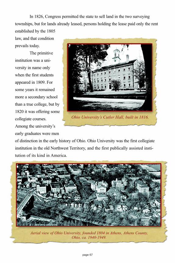
page 67
In 1826, Congress permitted the state to sell land in the two surveyingtownships, but for lands already leased, persons holding the lease paid only the rentestablished by the 1805law, and that conditionprevails today.
The primitiveinstitution was a uni-versity in name onlywhen the first studentsappeared in 1809. Forsome years it remainedmore a secondary schoolthan a true college, but by1820 it was offering somecollegiate courses.Among the university’searly graduates were menof distinction in the early history of Ohio. Ohio University was the first collegiateinstitution in the old Northwest Territory, and the first publically assisted insti-tution of its kind in America.
Aerial view of Ohio University, founded 1804 in Athens, Athens County,Ohio, ca. 1940-1949.
Ohio University’s Cutler Hall, built in 1816.
Ohio Lands 5-30-02.qxd 6/19/2002 4:27 PM Page 67

page 68
Miami University John Cleves Symmes, as we have noted, was involved in several diffi-
culties while trying to develop the land he and his associates had purchasedbetween the Miami rivers. Among them was his failure to honor the sale pro-vision requiring him to set-aside a full surveying township in support of highereducation. Congress expected Symmes either to give the federal governmentland in that amount from his grant or to pay $15,360, plus interest from the dateof his 1794 patent. Although Symmes had conflicts with Congress, he still hadpolitical clout, having been chosen by Congress as one of the three judges forthe Northwest Territory.
Congress declared in September, 1803 that 23,321 acres (36.4 squaremiles) located in the Congress Lands west of the Great Miami were to be setaside for “an academy, other public schools and seminaries of learning.” The setaside land is located in modern Butler County. It benefited Miami University,chartered in 1809 by the state legislature in a town the legislature namedOxford. Secondary level classes began in 1818, collegiate courses followed in1824, and the first collegiate class graduated in 1826. Unfortunately, as in otherinstances involving the leasing of public lands for school purposes, Miamirealized little income, for the land was leased for 99 years, renewable forever, atwhat is today a negligible rate.
The earliest known photo of the Miami campus, ca. 1858. The large buildingwas known as either “The Main Building” or simply “Old Main.” The two smaller buildings were the North and South Dormitories.
Photo courtesy of the Miami University Archives.
Ohio Lands 5-30-02.qxd 6/19/2002 4:27 PM Page 68

page 69
The Ohio State University While the Civil War was raging, Congress passed the Morrill Act of
1862. It offered land grants to any state or territory that would establish acollege focused on agriculture and the mechanic arts. The Morrill Act thusbecame the basis for the nation’s impressive “land grant” universities, most ofwhich are A&M (Agricultural and Mechanical) universities.
On February 9, 1864, the Ohio legislature accepted this act’s terms andreceived 30,000 acres of public land for each federal senator and representative.Since Ohio had two senators and 19 representatives, the state was entitled to630,000 acres. Federal lands were no longer available in Ohio, however, so thestate accepted land scrip in its place. Land scrip, issued by the federal gov-ernment, could be used to acquire land anywhere in the public domain open forprivate entry. Instead of buying land, Ohio sold its land scrip for $342,450.80,about 54 cents per acre. This became the university’s initial stake. The OhioAgricultural and Mechanical College was chartered in 1870, opened its doors tostudents in 1873, and graduated its first class in 1878. In addition to the MorrillGrant, the state legislature assigned the school at least 76,735 acres of unlocated
Ohio State University’s University Hall, 1874 in Columbus, Ohio, Photo courtesy of: The Ohio State University.
Ohio Lands 5-30-02.qxd 6/19/2002 4:27 PM Page 69

page 70
lands remaining in the Virginia Military District. These lands were sold or quitclaimed to individuals until the 1940s.
Though initially designed to be an A&M college, the school’s trusteessoon decided its curriculum should reach beyond agriculture and the mechanicalarts, and, consistent with this belief, they renamed the school Ohio StateUniversity. To emphasize its place in the state system, the name later becameThe Ohio State University.
Original Surveys Influence Ohio’s Development The original surveys of federal lands in Ohio often defined regions set
aside for the benefit of specific groups. Survey lines defining congressional landgrants became, in effect, boundaries setting off one cultural group from another.Ohio, therefore, was a mosaic of diverse peoples from its beginning. Thesegroups of dissimilar background, with different economic, political, and socialtraditions, were present in large enough numbers, and they maintained theirregional hold long enough to leave enduring marks upon Ohio. To this day, adiscerning viewer can find cultural traces that the state’s earliest settlers left intheir various regions.
Ohio State University’s First Graduating Class 1878 in Columbus, Ohio, Photo courtesy of: The Ohio State University.
Ohio Lands 5-30-02.qxd 6/19/2002 4:27 PM Page 70

New Englanders established the state’s first authorized, enduring set-tlement at Marietta in April, 1788, in lands purchased by the Ohio Company ofAssociates. Shortly thereafter, a larger group of New Englanders moved into theConnecticut Western Reserve, a region Connecticut had sold to private landdevelopers. These two centers of New England influence supported northernvalues - federalism, internal improvements, business enterprise, banks, andpublic schools supported by tax money.
In south central Ohio, western Virginians and Kentuckians dominatedthe Virginia Military District, infusing the region with the values of the UplandSouth–localism and states’ rights, decentralization, livestock raising as an agri-cultural specialty, schooling to be paid for by those attending, and a more laid-back lifestyle than was found among New Englanders.
The Seven Ranges was not designed to favor a particular cultural group,but its proximity to the Ohio River attracted frontier Pennsylvanians, westernVirginians and others who simply moved across the river to their new homes.They were a somewhat diverse group, but the strong Scots-Irish presence amongthem was noted for its independence, antipathy toward Indians, and love ofpolitical and religious disputation.
John Cleves Symmes and associates sold much of the Miami Purchaseto fellow New Jerseyites and other Middle States people, some of whom cameto settle between the Miamis and some who sold their holdings to others. TheMiami Purchase was culturally mixed from the start because of its easy accessto Kentuckians seeking more secure land titles, and because it bordered theOhio River, the main avenue to the West for migrants. Cincinnati, the region’sfocus, quickly became Ohio’s largest and most cosmopolitan city, attracting adiversity of people including Ohio’s largest concentration of free blacks andunknown numbers of fugitive slaves.
Other cultural groups in early Ohio included Pennsylvania Germans.Although Congress bestowed no land grant upon them, they tended initially tocluster within the Congress Lands of the Ohio River Survey located immedi-ately south of the Western Reserve. They brought their language, agriculturalpractices, and various Protestant religious preferences to this region. Congress
page 71
Ohio Lands 5-30-02.qxd 6/19/2002 4:27 PM Page 71

designed the French Grants and the Moravian Grants to benefit people with dis-tinctive social and cultural outlooks, but their numbers were too small for themto have statewide impact.
A salad bowl of peoples, each distinct but living close by people dif-ferent from themselves, organized the State of Ohio. No one group was dom-inant enough to impose its will upon the others, although it might assume for atime the leadership role in a particular political, economic, or social cause. Earlypolitical leadership, for example, fell to Democratic Republicans from theregions largely inhabited by persons of southern origin. They substantially out-numbered Federalist New Englanders. On the other hand, decades later NewEngland influence tended to define Ohio’s move toward tax-supported schools,internal improvements, and support for the great antebellum social reformmovements, especially anti-slavery.
Migration into the state from other parts of the Union was accompaniedby a strong flow of immigrants directly from Europe. They came principallyfrom Great Britain, Ireland, and the various German states. The British (English,Scots, Welsh) settled widely across the state, having nothing to do with surveyboundaries. Nor did the Irish confine themselves to a particular region. In time,Irish immigrants tended to cluster in villages and cities.
The German immigrants were also located in many parts of the state,but those who were primarily farmers tended to cluster in new lands recentlyopened. About 1830, Germans by the thousands started moving into northcentral, west central, and northwestern Ohio, and this movement lasted fordecades. It was common for Germans to come to Cincinnati, where brokersassisted them in acquiring government land or land sold by speculators. Most ofthis land was located in those surveys located south and east, and north and eastof the Principal Meridian and Base Line. It was originally surveyed between1819 and 1821. Some later located in the Michigan Survey.
This immigration was large enough and enduring enough to give aflavor to these large regions of Ohio. There were cultural splits among theGermans, most notably between Roman Catholic and Protestant believers,leading to the establishment of villages which were exclusively one or the other.
page 72
Ohio Lands 5-30-02.qxd 6/19/2002 4:27 PM Page 72

In large part, however, values were shared–respect for the German language(despite various dialects), architecture, agricultural practices, food specialties, asense of neatness and concern for property, and an enduring social and politicalconservatism. As Germans and others moved into northwestern Ohio, they wereaided by the Miami and Erie Canal and by the Maumee Road connecting theMaumee River with the Western Reserve. Both were built with funds derivedfrom the sale of federal land granted to Ohio for these purposes.
Ohio’s growth and development proceeded at an impressive pace, sothat by 1840 it had become the nation’s third most populous state, a distinctionit would hold until 1890. In the process, the original survey lines were often lostto the public eye. In a few cases, such as the 41st parallel of latitude definingthe Western Reserve’s southern boundary, a portion of a survey line serves aspart of the boundary of a county, but most counties were erected independent ofsurvey lines. Many contain lands from more than one original survey. FranklinCounty, for instance, has some townships laid out on the six mile square grid ofthe East of Scioto Survey, some on the five mile square grid of the United StatesMilitary District, some subject to the special considerations of the RefugeeGrant, and some formed in the helter skelter of the Virginia Military District.
A special case is the Greenville Treaty Line. Between the TuscarawasRiver and the Ohio-Indiana border, it cuts west by southwest through a numberof counties, dividing one original survey pattern from another. It is interestingthat an agreement, forged in 1795 with Indian peoples, continues to impact uponcontemporary Ohioans.
Ohio may no longer be a salad bowl of diverse people. Groups have losttheir distinctiveness through mobility, intermarriage, new immigration, and thecultural blending wrought by a media-invoked cultural salad dressing pouredover us all.
The most meaningful original survey lines that endure today are thosemarking state boundaries. They do not set us apart. They embrace us all.
page 73
Ohio Lands 5-30-02.qxd 6/19/2002 4:27 PM Page 73

page 75
Appendix
The Origin of Ohio’sCounty Names
(Date in parentheses is year county was established, it may differ from year it was actually organized.)Adams (1797), named for our second president, John Adams, during whose administration the county
was organized.Allen (1820), probably named for either Ethan Allen, a hero of the Revolutionary War or John L.
Allen, a hero of the War of 1812. Both men were colonels.Ashland (1846), named after “Ashland,” home of the Whig candidate for President, Henry Clay,
outside Lexington, Kentucky.Ashtabula (1808), named after the Ashtabula River which meant “Fish River” in the local Indian
dialect.Athens (1805), the county is named after Athens, Greece.Auglaize (1848), named for the Auglaize River. “Auglaize” is a Shawnee Indian word meaning
“fallen timbers.”Belmont (1801), comes from the French words “belle monte,” meaning “beautiful mountain,”
describing the hills of the county.Brown (1818), named for Gen. Jacob Brown, a hero of the War of 1812. Georgetown, the county
seat, was the boyhood home of Ulysses Simpson Grant, Civil War General and 18th President ofthe United States.
Butler (1803), named for Major General Richard Butler, killed during the disastrous defeat of GeneralArthur St. Clair by the Indians on Nov. 4, 1791.
Carroll (1833), took the name Carroll from Charles Carroll of Carrollton, Maryland, the last survivingsigner of the Declaration of Independence, who died in Baltimore on November 14, 1832, at theage of 96.
Champaign (1805), is French and means “a plain,” descriptive of the level land in the area.Clark (1818), named for Brigadier General George Rogers Clark who defeated the Shawnee Indians
in a battle near Springfield, on August 8, 1780.Clermont (1800), comes from the French word meaning “clear mountain.”Clinton (1810), named in honor of George Clinton, who was vice-president of the United States when
the county was formed.Columbiana (1803), derived from Christopher Columbus and Anna.Coshocton (1810), is an anglicized version of the Indian village “Goschachgunk” or “Goschaching”
meaning “Black Bear Town” or “where there is a river crossing.”Crawford (1820), named in honor of Col. William Crawford who was burned at the stake in 1782 by
Indians.Cuyahoga (1808), named for the Cuyahoga River. Cuyahoga is an Indian word meaning “crooked,”
or “winding stream.”Darke (1809), named for Gen. William Darke, Revolutionary War hero.Defiance (1845), named for Fort Defiance built in 1794 by General Anthony Wayne.
Ohio Lands 5-30-02.qxd 6/19/2002 4:27 PM Page 75

page 76
Delaware (1808), named for the Delaware Indians who came from the Delaware River area nearPhiladelphia.
Erie (1838), named for the Erie Indian tribe. In their Indian dialect the word “erie” meant “cat” or“wildcat.”
Fairfield (1800), Arthur St. Clair, Governor of the Northwest Territory, named this county for thebeauty of its “fair fields.”
Fayette (1810), named for Marie Joseph Paul Yves Roch Gilbert du Motier, the Marquis de Lafayette.He served as an American Major General in the Revolutionary War and was named an honoraryU.S. citizen in 1803.
Franklin (1803), named for Benjamin Franklin, printer and diplomat.Fulton (1850), named for Robert Fulton, inventor of the steamboat.Gallia (1803), is derived from Gaul, the ancient name of France.Geauga (1806), the name Geauga or Sheauga was one given by the Indians to the Grand River which
flows through the county. It means “raccoon.”Greene (1803), named for Gen. Nathaniel Greene, Revolutionary War hero.Guernsey (1810), due to the fact that many of the original settlers came from the Isle of Guernsey in
the English Channel.Hamilton (1790), named for Alexander Hamilton, the first Secretary of the Treasury, 1789-1795.Hancock (1820), named for John Hancock, President of the Continental Congress (1775-1777) and
first signer of the Declaration of Independence.Hardin (1820), named for Colonel John Hardin who was executed by the Indians while on a peace
mission in 1792.Harrison (1813), named for General William Henry Harrison, a hero of the War of 1812. First U.S.
President to have lived in Ohio.Henry (1820), named for Patrick Henry, Governor of Virginia 1776-1779 and 1784-1786; a cele-
brated orator of the Revolutionary War period.Highland (1805), describes the county’s terrain.Hocking (1818), derived its name from the Indian word “Hoch-Hoch-ing” which meant “a bottle.”
The Hocking River flows though this county which was once claimed by the Wyandot Indians.Holmes (1824), named for Major Andrew H. Holmes, who was killed during Major George
Croghan’s unsuccessful attack on Fort Mackinac (Michigan) on August 4, 1814.Huron (1809), the name Huron was given by the French to the Wyandot Indian tribe who lived in this
area.Jackson (1816), named for Major General Andrew Jackson, who defeated the British at the Battle of
New Orleans, January 8, 1815.Jefferson (1797), named for Thomas Jefferson, statesman and Vice President of the United States,
March 4, 1797 to March 3, 1801, and the 3rd President of the U.S. (1801-09).Knox (1808), named for General Henry Knox, the first U.S. Secretary of War.Lake (1840), named because it borders on Lake Erie; Ohio’s smallest county in land area.Lawrence (1815), named for Captain James Lawrence, commander of the U.S. Frigate Chesapeake
during the War of 1812.Licking (1808), derived its name from the principal stream flowing through the county. Pioneers
called it the “Licking River”, but it was called “Pataskala” by the Indians. The river received itsname from salt licks in the area.
Logan (1818), named for Gen. Benjamin Logan, who destroyed the Shawnee Indians Mac-o-cheeVillages in the area in 1786.
Lorain (1822), named after the Province of Lorraine, France.
Ohio Lands 5-30-02.qxd 6/19/2002 4:27 PM Page 76

page 77
Lucas (1835), named for Robert Lucas, Ohio Governor 1832-1836, who personally commanded Ohiotroops in the 1835 boundary dispute with Michigan. First territorial Governor of Iowa 1838-1841.
Madison (1810), named for James Madison, U.S. President from March 4, 1809 to March 3, 1817.Mahoning (1846), derives its name from the Mahoning River. Mahoning is from the Indian word
“Mahoni,” meaning a “lick” or “Mahonink,” meaning “at the lick.”Marion (1820), named in honor of Gen. Francis Marion of South Carolina, the “Swamp Fox” of
Revolutionary War fame.Medina (1812), named for Medina in Arabia, the town to which Mohammed fled from Mecca.Meigs (1819), named for Return Jonathan Meigs, Jr., Ohio Governor 1810-1814 and Postmaster
General 1814-1823 who lived in Marietta.Mercer (1820), named in honor of Gen. Hugh Mercer, who was killed at the Battle of Princeton, New
Jersey, on January 3, 1777.Miami (1807), named for the Miami Indians who claimed Western Ohio and whose principal village,
Pickawillany, was located near Piqua.Monroe (1813), named for James Monroe, U.S. Secretary of State, 1811-1817, and later the fifth
President of the United States, 1817-1825.Montgomery (1803), named for General Richard Montgomery who lost his life in
the assault on Quebec during the Revolutionary War.Morgan (1817), named in honor of Gen. Daniel Morgan, who won a brilliant victory against the
British at Cowpens, South Carolina, January 17, 1781.Morrow (1848), named for Jeremiah Morrow, Congressman 1803-1813; 1840-1843, U.S. Senator
1813-1819, and Ohio Governor 1822-1826.Muskingum (1804), is an old Delaware Indian word meaning “a town by the river.”Noble (1851), named out of respect for James Noble, a pioneer settler who first bought land in the
county in 1814.Ottawa (1840), named for the Ottawa Indian tribe. The name in their language meant “trader.”Paulding (1820), named for John Paulding, one of three soldiers who captured Major John Andre,
British spy in the Revolutionary War.Perry (1818), named in honor of Commodore Oliver Hazard Perry, who defeated the British in the
naval Battle of Lake Erie, September 13, 1813.Pickaway (1810), named from a misspelling of the tribe of Indians, known as Piqua, a branch of the
Shawnee Tribe.Pike (1815), bears the name of Brig. Gen. Zebulon Montgomery Pike, who discovered Pike’s Peak in
Colorado in 1806.Portage (1808), name comes from the old Indian portage path, eight miles in length, between the
Cuyahoga and Tuscarawas rivers.Preble (1808), named for Capt. Edward Preble, naval commander in the Revolutionary War and the
War with Tripoli.Putnam (1820), named for Israel Putnam, Revolutionary War Major General, who gained fame at the
Battle of Breed’s Hill, often misnamed the Battle of Bunker Hill, on June 17, 1775.Richland (1808), named for the richness of its soil.Ross (1798), named by Territorial Governor Arthur St. Clair for his friend, James Ross of
Pennsylvania, U.S. Senator 1794-1803.Sandusky (1820), is a derivative of an Indian word meaning “cold water.” In Wyandot and Huron
languages it is “Sa-un-dos-tee” meaning “water within water pools.”Scioto (1803), takes its name from the Scioto River which flows through the county. Scioto comes
from a Indian word “Scionto,” meaning “deer.”
Ohio Lands 5-30-02.qxd 6/19/2002 4:27 PM Page 77

page 78
Seneca (1820), named for the Seneca Indians, who had a 40,000 acre reservation north of Tiffin from1817-1831.
Shelby (1819), named for Isaac Shelby, Revolutionary War hero and first Governor of Kentucky.Counties in nine states are named for him.
Stark (1808), named for Gen. John Stark of Revolutionary War fame.Summit (1840), derived its name for having the highest land on the line of the Ohio and Erie Canal,
known as “Portage Summit.”Trumbull (1800), in the Connecticut Western Reserve, was named for Jonathan Trumbull, Jr.,
Governor of Connecticut 1797-1809.Tuscarawas (1808), named for the Tuscarawas River, an Indian term perhaps meaning “open mouth”.Union (1820), named because it was formed from parts of Delaware, Franklin, Madison, and Logan
counties.Van Wert (1820), named for Isaac Van Wert, one of the three captors of British spy, Major John
Andre. Actual spelling of Van Wert’s name was “Van Wart.” The spelling was changed due to anillegible entry in Congressional records.
Vinton (1850), named for Samuel Finley Vinton, an Ohio Statesman and U.S. Congressman, knownas the “Father of the Department of Interior.”
Warren (1803), named for Gen. Joseph Warren, who was killed at the Battle of Breed’s (Bunker) Hill,on June 17, 1775.
Washington (1788), Ohio’s first county and named in honor of George Washington, who was pres-ident of the Constitutional Convention at the time the county was formed.
Wayne (1808), named for Major General Anthony Wayne, Revolutionary War hero, later General-in-Chief of the U.S. Army 1791-1796. Defeated the Indians at the “Battle of Fallen Timbers,” August20, 1794.
Williams (1820), honors David Williams, one of three captors of Major John Andre on September 23,1780.
Wood (1820), named after Major Eleazer D. Wood, U.S. Army-Engineers, who built Fort Meigs in1813 while serving on the staff of General William Henry Harrison.
Wyandot (1845), named for the Wyandot Indians, the last Indian tribe in Ohio to cede their reserva-tions March 17, 1842. They moved to lands west of the Mississippi River in July, 1843.
Ohio Lands 5-30-02.qxd 6/19/2002 4:27 PM Page 78

Additional ReadingBrumbaugh, Gaius, Marcus. “Revolutionary War Records, Volume 1, Virginia.”
Washington D.C., Gaius Marcus Brumbaugh, 1936.
Bell, Carol Willsey. “Ohio-Lands: Steubenville Land Office 1800-1820.” Youngstown:Carol Willsey Bell, 1985.
Bell, Carol Willsey. “Ohio-Guide to Genealogical Sources.” Baltimore: GenealogicalPublishing Co., In. 1988.
Berry, Ellen T. and David A. “Early Ohio Settlers - Purchasers of Land in SoutheasternOhio, 1800-1840.” (Marietta Land Office), Baltimore, genealogical Publishing Co.,1984.
Berry, Ellen T. and David A. “Early Ohio Settlers - Purchasers of Land in East and EastCentral Ohio, 1800-1840.” Baltimore: Genealogical Publishing Co., 1984.
Carstensen, Vernon, ed. “The Public Lands: Studies in the History of the PublicDomain.” Madison, 1963.
Clark, Marie Taylor. “Ohio Lands: Chillicothe Land Office, 1800-1829.” Chillicothe:Marie Taylor Clark, 1984.
Clark, Marie Taylor. “Ohio Lands: South of the Indian Boundary Line.” Chillicothe:Marie Taylor Clark, 1984.
Downes, Randolph C. “Evolution of Ohio County Boundaries.” Ohio Archaeologicaland Historical Publications No. XXXVI, Columbus: OA&H Society, 1927,Reprinted 1970.
Dyer, Albion Morris. “First Ownership of Ohio Lands.” Baltimore GenealogicalPublishing Co., Inc., 1911. Reprinted 1982.
Gates, Paul W. “History of Public Land Law Development.” Washington D.C. PublicLand Law Review Commission, 1968.
Hatcher, Harlan. “The Western Reserve: The story of New Connecticut in Ohio.” Kent:The Kent State University Press, 1991. Reprinted.
Hulbert, Archer B., ed. “Ohio in the Time of the Confederation.” 2 Vols. Marietta:Marietta College, 1917.
Hulbert, Archer B. “The Records of the Original Proceedings of the Ohio Company.” 2Vols. Marietta: Marietta College, 1917.
Peters, William E. “Ohio Lands and Their History.” 3rd Ed., Athens: W.E. Peters, 1930.Reprinted.
page 79
Ohio Lands 5-30-02.qxd 6/19/2002 4:27 PM Page 79

Riegel, Mayburt Stephenson. “Early Ohioans’ Residences from the Land GrantRecords.” Mansfield: Ohio Genealogical Society, 1976.
Rohrbough, Malcom J. “The Land Office Business.” New York: Oxford UniversityPress, 1968.
Treat, Payson, J. “The National Land System 1785-1820.” New York, 1910.
Sherman, Christopher E. “Original Land Subdivisions.” Volume III, Final Report - OhioTopographic Survey. Columbus: Ohio Department of Natural Resources, 1925.Reprinted 1982. Wall Map separate.
Smith, Clifford Neal. “Federal Land Series, Volumes 1-4.” Chicago: American LibraryAssociation, 1972-1982.
Smith, Alma Aicholtz. “The Virginia Military Surveys of Clermont and HamiltonCounties, Ohio 1787-1849.” Cincinnati: Alma Aicholtz Smith, 1985.
White, C. Albert. “A History of the Rectangular Survey System.” Washington D.C.:Government Printing Office, 1982.
page 80
Ohio Lands 5-30-02.qxd 6/19/2002 4:27 PM Page 80

page 81
We gratefully acknowledge the following people and organizations for providing The Official Ohio Lands Book with images and information:
Dr. George W. Knepper, Distinguished Professor of History, Emeritus, The University of Akron
Annette Salrin for providing the painting used for the cover.
The Ohio Historical Society for use of most of the images in this book thatwere provided by the Archives/Library Division.
The Ohio State University, for permission to print the 1st Graduating Class and the University Hall, ca. 1874 photographs.
Miami University, for permission to print the earliest known photo of the Miami campus, ca. 1858.
The Ohio Department of Natural Resources for permission and the use of illustrations from C.E. Sherman’s Original Land Subdivisions, and
also for permission to print the Scioto Salt Springs photograph.
The Ohio Lands book has been published by the Auditor of State’s office for more than a decade. This current version is based on the efforts
of multiple employees in this current and prior administration.
To everyone who has provided advice and suggestions for this publication, sincere thanks and grateful appreciation for all your help.
Ohio Lands 5-30-02.qxd 6/19/2002 4:27 PM Page 81

THE OFFICIALOHIO LANDS BOOK
Written byDr. George W. Knepper