the most popular is under the dome of the rock. second under the dome of the spirits just north of...
TRANSCRIPT
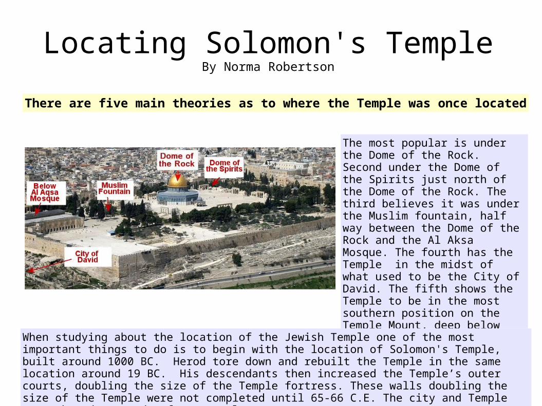
The most popular is under the Dome of the Rock. Second under the Dome of the Spirits just north of the Dome of the Rock. The third believes it was under the Muslim fountain, half way between the Dome of the Rock and the Al Aksa Mosque. The fourth has the Temple in the midst of what used to be the City of David. The fifth shows the Temple to be in the most southern position on the Temple Mount, deep below and to the west of the Al Aqsa Mosque, which I will be discussing.
When studying about the location of the Jewish Temple one of the most important things to do is to begin with the location of Solomon's Temple, built around 1000 BC. Herod tore down and rebuilt the Temple in the same location around 19 BC. His descendants then increased the Temple’s outer courts, doubling the size of the Temple fortress. These walls doubling the size of the Temple were not completed until 65-66 C.E. The city and Temple were then destroyed a few years later.
Locating Solomon's TempleBy Norma Robertson
There are five main theories as to where the Temple was once located

Josephus, a Jewish historian who lived during the time of the destruction of the Temple, is a good source concerning the Temple. He wrote that Herod's Temple complex was a furlong in length and width. A furlong by a furlong is approximately 600 x 600 fee600 x 600 feet.
The Temple house, Priest's court, and Women's court were rebuilt by Herod the Great pre-first century. Later, as Herod's decedents continued his work by extended the outer courts during the first century, then parts of Solomon's old walls were most likely removed. Notice the Wailing Wall is located on the upper left side of this diagram on the first century wall.
Solomon's Temple area ( in green)and the Herodian extended courts (in blue).
This is a diagram for the Southern location
This doubled the size of Solomon's Temple complex. Herod felt that the east gate was too beautiful to tear down, so refused to change it. They merely extended Solomon’s east wall to the north and to the south.

This survey map of the southwest section of the Temple Mount reveals an elaborate underground water system for this southern location.
The aqueduct entered the mount through Wilson's Arch. It didn't go up hill from there towards the Dome of the Rock, which would have been the case if the Temple had been located there, but instead the channel was laid towards the south, down hill from where it entered the Mount. Further indicating that the Temple was located at the south end of the mount.
It appears that the Muslims closed off the water channels leading to the south when they built their fountain. The aqueduct was built by Solomon bringing water to the Temple from the Etam Spring (Ain Atan) near Solomon’s pools. The Dome of the Rock is 20 feet
higher than the aqueduct.

The Talmud (Yoma' 3 fol 41) says that a conduit (aqueduct) ran from Atan (Etam) to the Temple. This tells us the Temple court was cleansed with water being brought to the Temple from the Spring of Etam near Bethlehem. It flowed to the Temple by use of an aqueduct. The water for cleaning the court did not come out of the Gihon Spring.
During the second temple period a new way of filling the Laver was devised. The laver was submerged into a specially-made pool under the court. The laver was then hoisted up by the first priest in the morning.
When laying the Temple diagram over the water channel map the large pool for filling the laver was right next to the Temple!
Another branch of this water system ended under the Temple court near the tables. The water channel could be opened to flood the court to cleanse it of the blood. There was a drain next to the altar where the water and blood would have drained into a blood channel leading to the Kidron Valley
The water system also has a branch going to where the Chamber of the Hearth would have been located in this theory. The Chamber of the Hearth had a Mikveh below it for the High Priest.

Recently photographs by Robert Hamilton, director of the British Mandate Antiquities Authority, who explored under the mosque after it was damaged by an earthquake in 1927, were released. One photo shows a Jewish mikveh under the Al Aqsa Mosque. This could possibly be the Mikveh that would have been located under the Chamber of the Hearth.
On the left, in red, is the Al Aqsa Mosque with the temple overlay to show the position of the Temple.
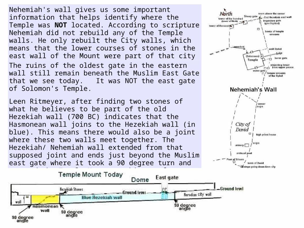
Nehemiah's wall gives us some important information that helps identify where the Temple was NOT located. According to scripture Nehemiah did not rebuild any of the Temple walls. He only rebuilt the City walls, which means that the lower courses of stones in the east wall of the Mount were part of that city wall that Nehemiah rebuilt.
The ruins of the oldest gate in the eastern wall still remain beneath the Muslim East Gate that we see today. It was NOT the east gate of Solomon's Temple.
Leen Ritmeyer, after finding two stones of what he believes to be part of the old Hezekiah wall (700 BC) indicates that the Hasmonean wall joins to the Hezekiah wall (in blue). This means there would also be a joint where these two walls meet together. The Hezekiah/ Nehemiah wall extended from that supposed joint and ends just beyond the Muslim east gate where it took a 90 degree turn and crossed the Temple Mount reaching as far as the edge of the Tyropeon Valley.
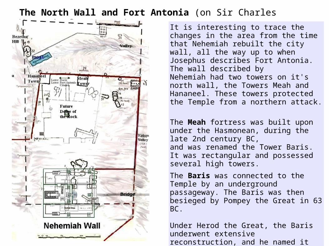
The North Wall and Fort Antonia (on Sir Charles Warren’s Survey map)
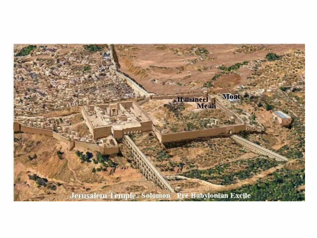
It is interesting to trace the changes in the area from the time that Nehemiah rebuilt the city wall, all the way up to when Josephus describes Fort Antonia. The wall described by Nehemiah had two towers on it's north wall, the Towers Meah and Hananeel. These towers protected the Temple from a northern attack.
The Meah fortress was built upon under the Hasmonean, during the late 2nd century BC, and was renamed the Tower Baris. It was rectangular and possessed several high towers.
The Baris was connected to the Temple by an underground passageway. The Baris was then besieged by Pompey the Great in 63 BC.
Under Herod the Great, the Baris underwent extensive reconstruction, and he named it Fort Antonia in honor of Mark Anthony.Fort Antonia, just as the Baris and the Meah before it, was located on the old north wall that Nehemiah rebuilt. It overlooked a moat on its north side.

The Moat
According to Josephus this moat separated Fort Antonia from the hill to its north.
This topographical map shows there was a natural land bridge between Fort Antonia and the lower hill to its north, called Bezetha. The moat was 200 feet long, and to the east of it was a ravine called the old Kidron Valley. The moat was cut for the purpose of separating the two hills, and making it impossible for catapults to be set up near the north wall of the Fortress, for lack of flat land. However attacking armies would just fill in the moat with debris and create a flat surface and break down the north wall taking the fortress. From there they could take the Temple.
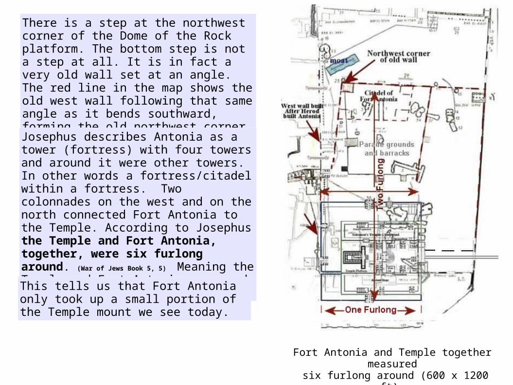
There is a step at the northwest corner of the Dome of the Rock platform. The bottom step is not a step at all. It is in fact a very old wall set at an angle. The red line in the map shows the old west wall following that same angle as it bends southward, forming the old northwest corner of Fort Antonia.
Josephus describes Antonia as a tower (fortress) with four towers and around it were other towers. In other words a fortress/citadel within a fortress. Two colonnades on the west and on the north connected Fort Antonia to the Temple. According to Josephus the Temple and Fort Antonia, together, were six furlong around. (War of Jews
Book 5, 5) Meaning the Temple and Fort Antonia were each 600 x 600 feet.
Fort Antonia and Temple together measured six furlong around (600 x 1200 ft).
This tells us that Fort Antonia only took up a small portion of the Temple mount we see today.

City walls during the first century
The city walls during the time of Nehemiah (yellow).Herod rebuilt this wall and also built a wall around the north quarter of the city (in green).A third city wall included the city of Bezetha (purple). This third wall connected to the old Hezekiah city wall on the east. There wasn't a wall between Bezetha hill and the moat.
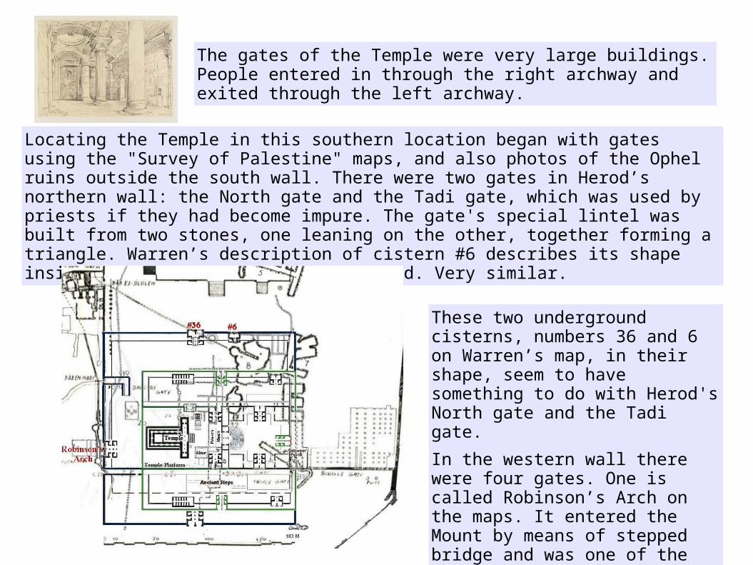
The gates of the Temple were very large buildings. People entered in through the right archway and exited through the left archway.
Locating the Temple in this southern location began with gates using the "Survey of Palestine" maps, and also photos of the Ophel ruins outside the south wall. There were two gates in Herod’s northern wall: the North gate and the Tadi gate, which was used by priests if they had become impure. The gate's special lintel was built from two stones, one leaning on the other, together forming a triangle. Warren’s description of cistern #6 describes its shape inside like a hollow truncated pyramid. Very similar.
These two underground cisterns, numbers 36 and 6 on Warren’s map, in their shape, seem to have something to do with Herod's North gate and the Tadi gate.
In the western wall there were four gates. One is called Robinson’s Arch on the maps. It entered the Mount by means of stepped bridge and was one of the temple gates described by Josephus.
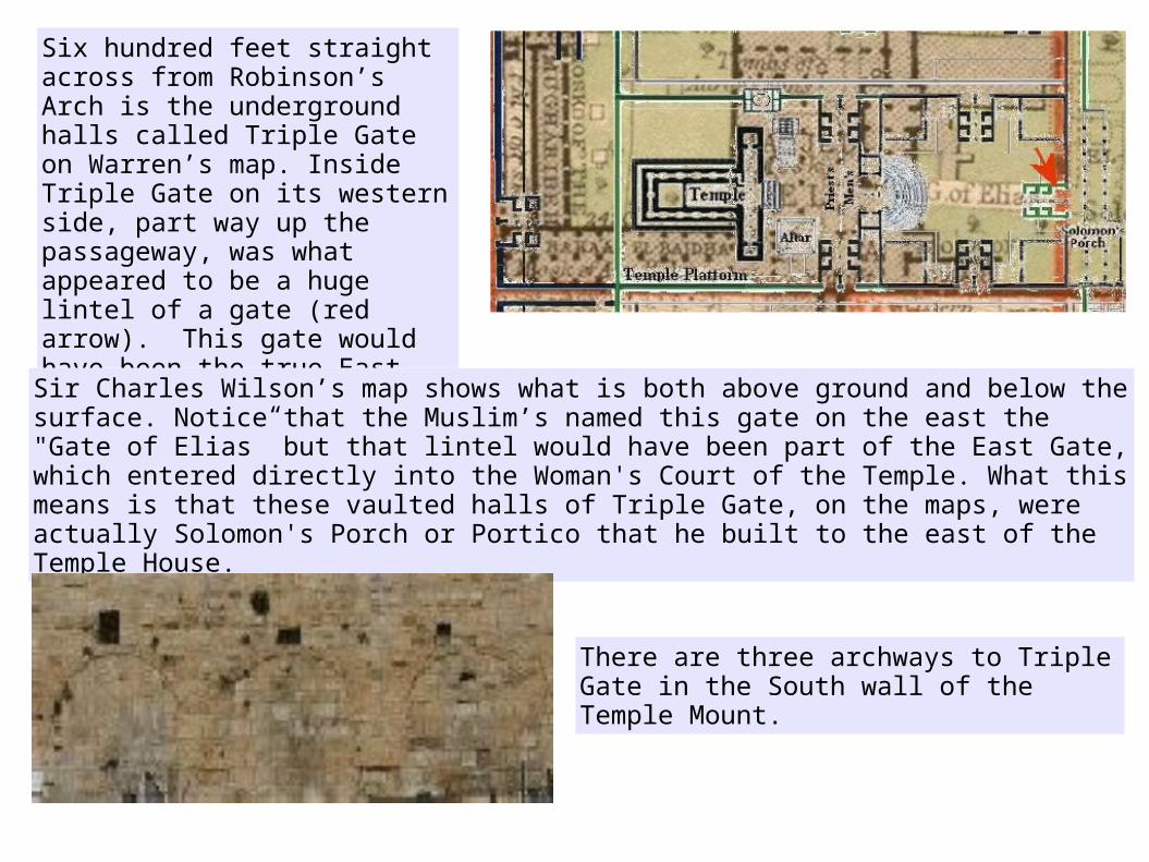
Six hundred feet straight across from Robinson’s Arch is the underground halls called Triple Gate on Warren’s map. Inside Triple Gate on its western side, part way up the passageway, was what appeared to be a huge lintel of a gate (red arrow). This gate would have been the true East Gate to the Temple.
Sir Charles Wilson’s map shows what is both above ground and below the surface. Notice that the Muslim’s named this gate on the east the "Gate of Elias” but that lintel would have been part of the East Gate, which entered directly into the Woman's Court of the Temple. What this means is that these vaulted halls of Triple Gate, on the maps, were actually Solomon's Porch or Portico that he built to the east of the Temple House.
There are three archways to Triple Gate in the South wall of the Temple Mount.

When Benjamin Mazar, in 1967, excavated the Ophel mound outside the South wall, ruins of steps were found leading down from the two arches on the right only. There were no steps to the arch on the left. In the southern theory the arch on the left was inside the east wall and the other two were outside the wall.
This would make the inside hall on the left (west) Solomon’s Stoa, which lined the eastern wall inside the Temple complex. The other two, on the right (east), entered an arched entryway, a porch, so to speak, to the east gate. The Kings entrance, because Solomon had built his palace just south of this on the Ophel Mound and he entered through the East Gate into the temple complex.
When entering the two arches on theright the East Gate would have been on the western wall of the portico and entered directly into the Women's Court.
At the time this picture was taken these halls were full of tons and tons of dirt and debris, leaving only the tops of the arches exposed. These halls do not lead up to the Mount surface, and never did.

To think that Solomon’s Porch might still exist to this day, buried beneath the surface of the Temple Mount, is amazing to say the least.
“Attached to the original temple of Solomon was the porch of judgment where king Solomon had constructed a large hall 50 cubits long and 30 cubits wide. The "porch" or "portico" was located on the east side of the outer court of the New Testament Temple of Herod.”
The lower section of the Triple Gate halls on Warren's map, is a three-aisled portico, and is approximately 50 x 30 Hebrew cubits and the woman's court was the outer court of the Temple. So this fits the description rather well.
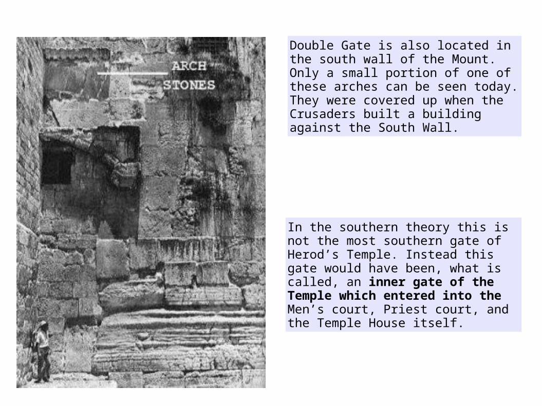
Double Gate is also located in the south wall of the Mount. Only a small portion of one of these arches can be seen today. They were covered up when the Crusaders built a building against the South Wall.
In the southern theory this is not the most southern gate of Herod’s Temple. Instead this gate would have been, what is called, an inner gate of the Temple which entered into the Men’s court, Priest court, and the Temple House itself.
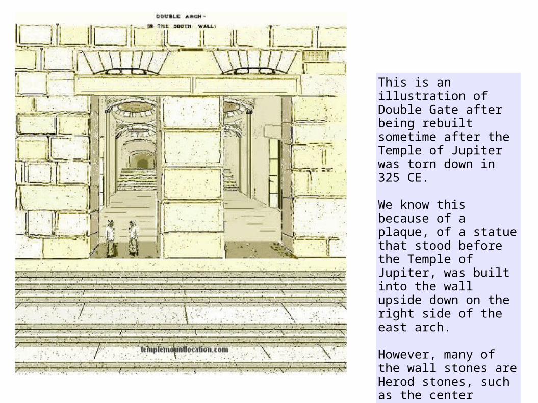
This is an illustration of Double Gate after being rebuilt sometime after the Temple of Jupiter was torn down in 325 CE.
We know this because of a plaque, of a statue that stood before the Temple of Jupiter, was built into the wall upside down on the right side of the east arch.
However, many of the wall stones are Herod stones, such as the center divider between the two gates and the lower courses of the wall itself.
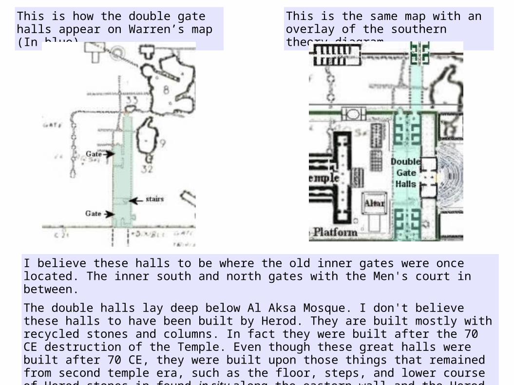
This is how the double gate halls appear on Warren’s map (In blue)
I believe these halls to be where the old inner gates were once located. The inner south and north gates with the Men's court in between.
The double halls lay deep below Al Aksa Mosque. I don't believe these halls to have been built by Herod. They are built mostly with recycled stones and columns. In fact they were built after the 70 CE destruction of the Temple. Even though these great halls were built after 70 CE, they were built upon those things that remained from second temple era, such as the floor, steps, and lower course of Herod stones in found in situ along the eastern wall and the Herod stones of the double arches in the south wall, which are also in situ.
This is the same map with an overlay of the southern theory diagram
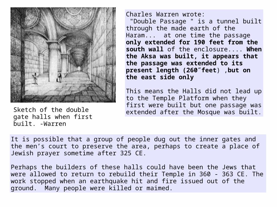
It is possible that a group of people dug out the inner gates and the men’s court to preserve the area, perhaps to create a place of Jewish prayer sometime after 325 CE.
Perhaps the builders of these halls could have been the Jews that were allowed to return to rebuild their Temple in 360 - 363 CE. The work stopped when an earthquake hit and fire issued out of the ground. Many people were killed or maimed.
Charles Warren wrote: "Double Passage " is a tunnel built through the made earth of the Haram... at one time the passage only extended for 190 feet from the south wall of the enclosure.... When the Aksa was built, it appears that the passage was extended to its present length (260 feet) ,but on the east side only”
This means the Halls did not lead up to the Temple Platform when they first were built but one passage was extended after the Mosque was built.
Sketch of the double gate halls when first built. -Warren
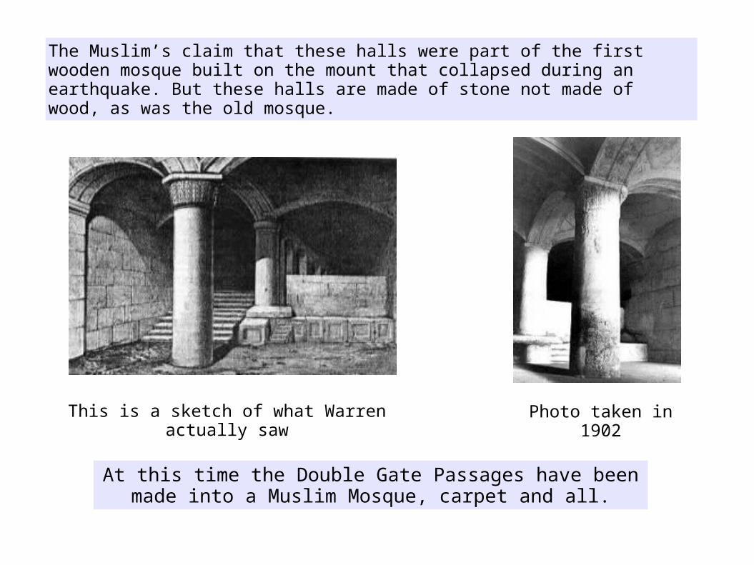
The Muslim’s claim that these halls were part of the first wooden mosque built on the mount that collapsed during an earthquake. But these halls are made of stone not made of wood, as was the old mosque.
This is a sketch of what Warren actually saw Photo taken in 1902
At this time the Double Gate Passages have been made into a Muslim Mosque, carpet and all.

The mishna. Para 3.3 tells us that "The Temple Mount and the Temple Courts had a hollow space beneath them in case there was a grave in the depths".
“From the inner court the Priests entered the hollow by lifting a marble slab. In the North (inner) gate near the threshold there was a black slate slab that was also an entrance to these hollows”.
So not only do we find that there is a Jewish Mikveh below the Al Aqsa Mosque but also the required hollows that would have been cut into the rock below the Temple courts!
This is a photo by Robert Hamilton taken in 1927 of a rock cut passageway that is entered into by stairs leading down from the Double gate Hallways.

Trying to visualize the mount without this corner in the time of Herod is difficult, but that may have been the case. The upper portion of the wall, all the way around the mount, was built by the Muslims after 638 CE. Below that, is a portion that was constructed by the Romans and Bezintines.
Moving on to the southeast corner and East wall of the Temple Mount
The Hasmonean wall ending at this vertical line in the east wall tells us that their wall took a 90 degree turn westward at this point in the original wall.
In the lowest portion of the wall on the eastern side, there is a straight joint in the wall where the Hasmonean wall, second century BC, meets up with what is believed to be an Herodian wall built in the first century CE.

The question is, did Herod’s descendants build the wall from the Hasmonean wall all the way round to Triple Gate on the south wall, or was it built at a later time?
Within the Southeast corner is a series of terraced vaults.
The vaults are mistakenly called “Solomon's Stables” dubbed so by the Crusaders who used the upper vaults to stable their horses. Today that upper vault has been made into a subterranean Muslim Mosque.

Herod stones are unique in that they have a margin chiseled around its edge. In a Herod/Herodian built wall we would see stones that have matching equal margins, which the southeast corner does not have. In November 1868, Captain Charles Warren of the British Royal Engineers dug a vertical shaft around 90 feet down to the bedrock at the SE Angle of the Temple Mount Platform.
In the PALESTINE EXPLORATION FUND-1870. They believed them to be based on Phoenician letters.
As you can see this wall is made up of mismatched recycled Herod/Herodian stones taken from somewhere else and used to build this wall. Some of the stones even have mason marks on them. The masons marked the stones at the quarry so that the builders could place them properly to create the specified building, much like a prefab house today.
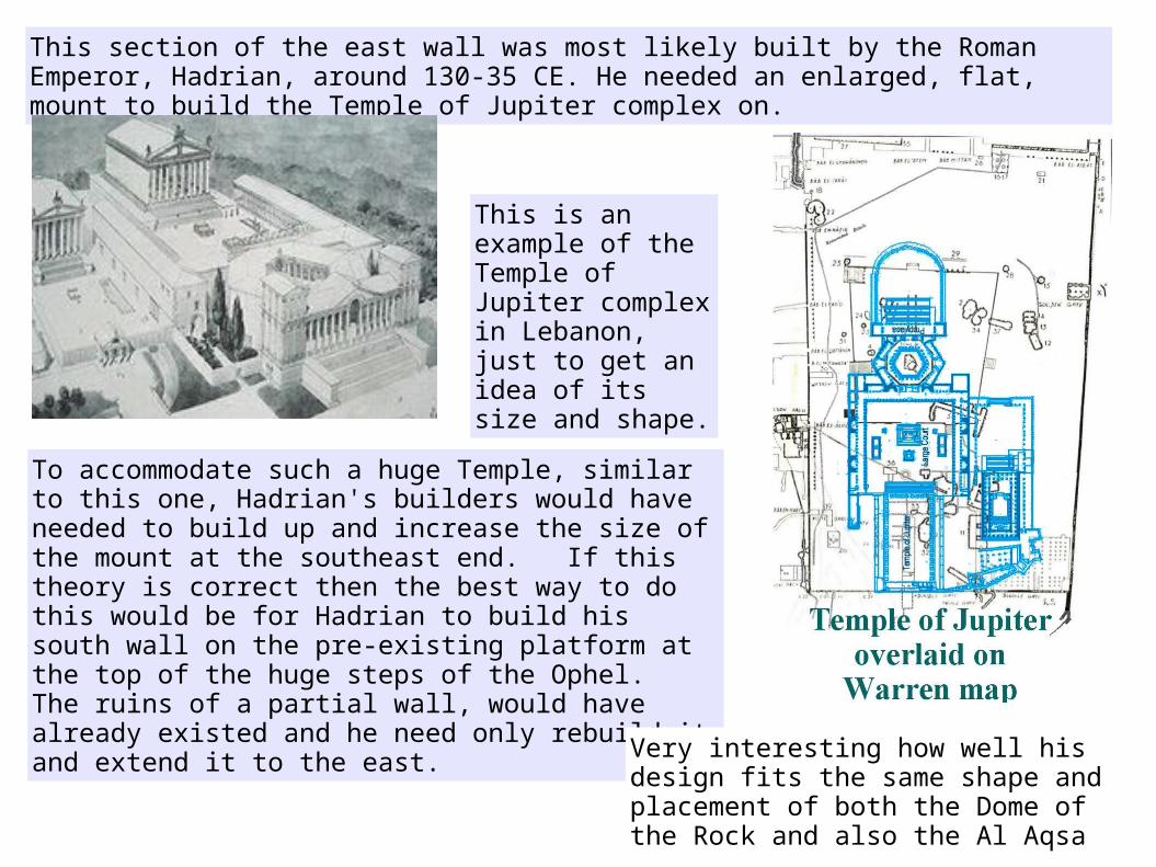
This section of the east wall was most likely built by the Roman Emperor, Hadrian, around 130-35 CE. He needed an enlarged, flat, mount to build the Temple of Jupiter complex on.
To accommodate such a huge Temple, similar to this one, Hadrian's builders would have needed to build up and increase the size of the mount at the southeast end. If this theory is correct then the best way to do this would be for Hadrian to build his south wall on the pre-existing platform at the top of the huge steps of the Ophel. The ruins of a partial wall, would have already existed and he need only rebuild it and extend it to the east.
This is an example of the Temple of Jupiter complex in Lebanon, just to get an idea of its size and shape.
Very interesting how well his design fits the same shape and placement of both the Dome of the Rock and also the Al Aqsa
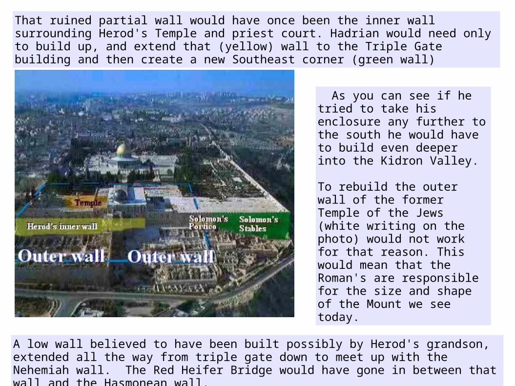
That ruined partial wall would have once been the inner wall surrounding Herod's Temple and priest court. Hadrian would need only to build up, and extend that (yellow) wall to the Triple Gate building and then create a new Southeast corner (green wall)
As you can see if he tried to take his enclosure any further to the south he would have to build even deeper into the Kidron Valley.
To rebuild the outer wall of the former Temple of the Jews (white writing on the photo) would not work for that reason. This would mean that the Roman's are responsible for the size and shape of the Mount we see today.
A low wall believed to have been built possibly by Herod's grandson, extended all the way from triple gate down to meet up with the Nehemiah wall. The Red Heifer Bridge would have gone in between that wall and the Hasmonean wall.

To build up the southeast corner to accommodate the Temple of Jupiter complex would require tearing down the bridge from the straight joint upward to the Portico of Solomon and then building the terraced vaults. It would require building a gate into this wall, which could then be reconnected with the bridge outside of the wall. The walled up arched openings can still be seen in the wall today near the straight joint.
This section of the east wall was not built by Herodian builders.
And of course the southeast corner of Solomon's stable didn't exist when Nehemiah was rebuilding the city wall. At that time one would have been able to see the east wall of triple gate (Solomon's Porch) perched on the very edge of the steep hill.
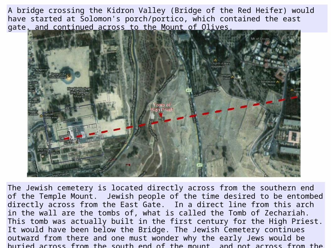
A bridge crossing the Kidron Valley (Bridge of the Red Heifer) would have started at Solomon's porch/portico, which contained the east gate, and continued across to the Mount of Olives.
The Jewish cemetery is located directly across from the southern end of the Temple Mount. Jewish people of the time desired to be entombed directly across from the East Gate. In a direct line from this arch in the wall are the tombs of, what is called the Tomb of Zechariah. This tomb was actually built in the first century for the High Priest. It would have been below the Bridge. The Jewish Cemetery continues outward from there and one must wonder why the early Jews would be buried across from the south end of the mount, and not across from the supposed Golden Gate in the east wall of today, or across from the Dome of the Rock itself.

This is a digital illustration of what Herod’s Temple Mount might have looked like in 70 CE.
The southern court of the Temple compound extended beyond the South wall onto the Ophel.
Of course the Temple house along with all the new buildings of Herod’s Temple were completely destroyed (not one stone upon another) in 70 CE, long before the ground level of the Temple Mount was raised to its new level.
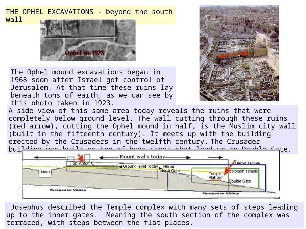
THE OPHEL EXCAVATIONS - beyond the south wall
The Ophel mound excavations began in 1968 soon after Israel got control of Jerusalem. At that time these ruins lay beneath tons of earth, as we can see by this photo taken in 1923.
A side view of this same area today reveals the ruins that were completely below ground level. The wall cutting through these ruins (red arrow), cutting the Ophel mound in half, is the Muslim city wall (built in the fifteenth century). It meets up with the building erected by the Crusaders in the twelfth century. The Crusader building was built on top of huge steps that lead up to Double Gate.
Josephus described the Temple complex with many sets of steps leading up to the inner gates. Meaning the south section of the complex was terraced, with steps between the flat places.
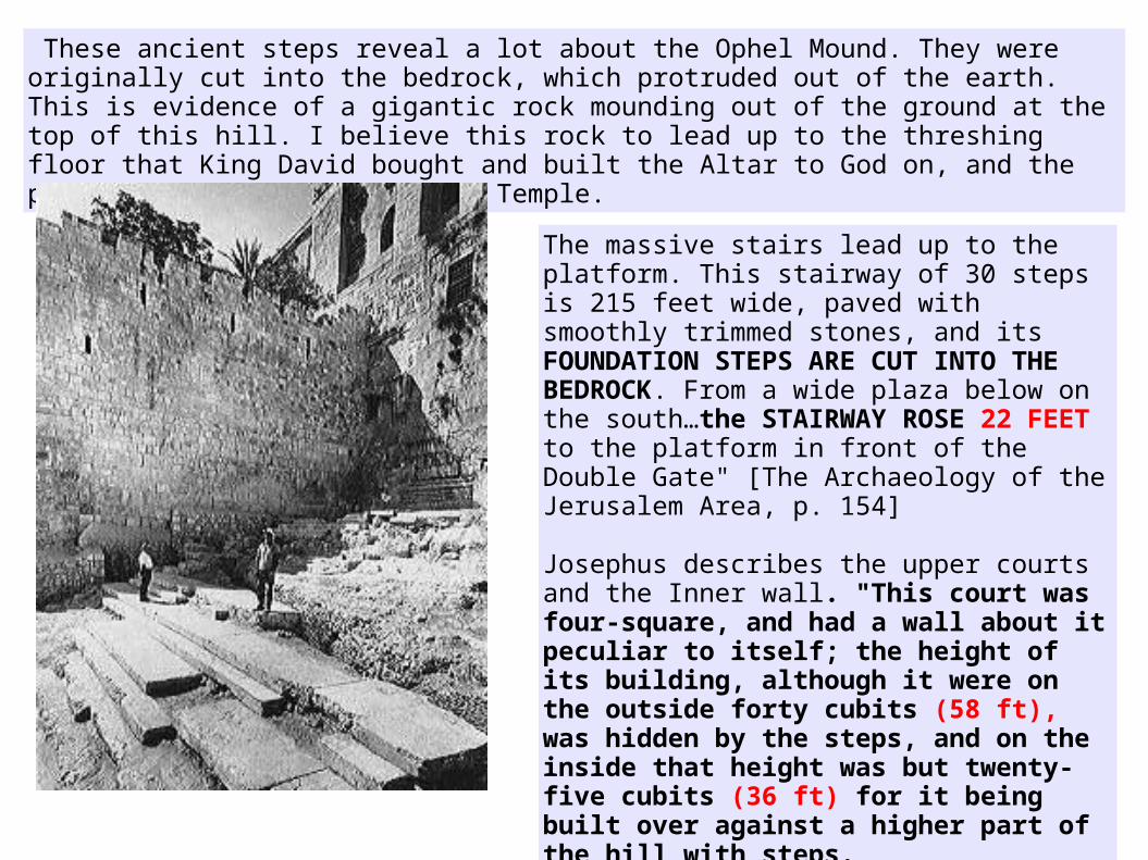
These ancient steps reveal a lot about the Ophel Mound. They were originally cut into the bedrock, which protruded out of the earth. This is evidence of a gigantic rock mounding out of the ground at the top of this hill. I believe this rock to lead up to the threshing floor that King David bought and built the Altar to God on, and the place where Solomon built the Temple.
The massive stairs lead up to the platform. This stairway of 30 steps is 215 feet wide, paved with smoothly trimmed stones, and its FOUNDATION STEPS ARE CUT INTO THE BEDROCK. From a wide plaza below on the south…the STAIRWAY ROSE 22 FEET to the platform in front of the Double Gate" [The Archaeology of the Jerusalem Area, p. 154]
Josephus describes the upper courts and the Inner wall. "This court was four-square, and had a wall about it peculiar to itself; the height of its building, although it were on the outside forty cubits (58 ft), was hidden by the steps, and on the inside that height was but twenty-five cubits (36 ft) for it being built over against a higher part of the hill with steps. (War of the Jews - BOOK 5, CH. 5)
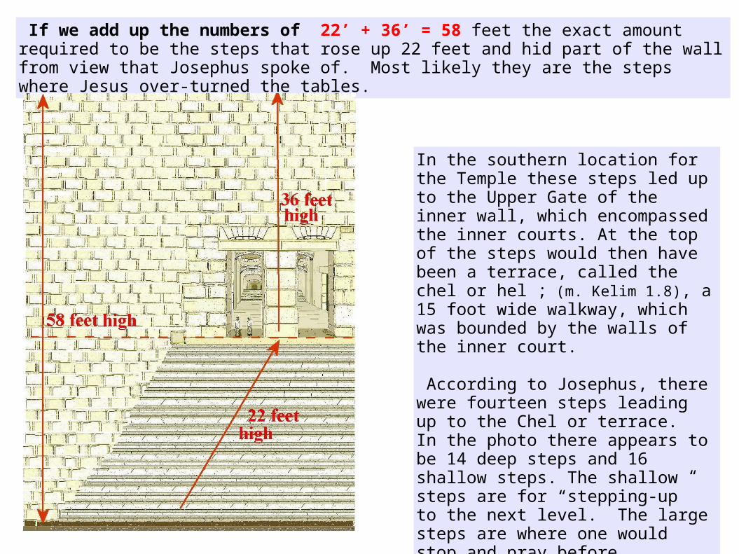
If we add up the numbers of 22’ + 36’ = 58 feet the exact amount required to be the steps that rose up 22 feet and hid part of the wall from view that Josephus spoke of. Most likely they are the steps where Jesus over-turned the tables.
In the southern location for the Temple these steps led up to the Upper Gate of the inner wall, which encompassed the inner courts. At the top of the steps would then have been a terrace, called the chel or hel ; (m. Kelim 1.8), a 15 foot wide walkway, which was bounded by the walls of the inner court.
According to Josephus, there were fourteen steps leading up to the Chel or terrace. In the photo there appears to be 14 deep steps and 16 shallow steps. The shallow steps are for “stepping-up” to the next level. The large steps are where one would stop and pray before ascending to the next step, the same as it was for the steps in the women’s court that led up to the eastern inner gate.
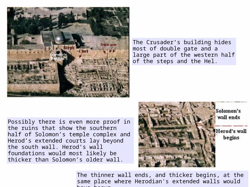
The Crusader’s building hides most of double gate and a large part of the western half of the steps and the Hel.
Possibly there is even more proof in the ruins that show the southern half of Solomon’s temple complex and Herod’s extended courts lay beyond the south wall. Herod’s wall foundations would most likely be thicker than Solomon’s older wall.
The thinner wall ends, and thicker begins, at the same place where Herodian's extended walls would have begun.
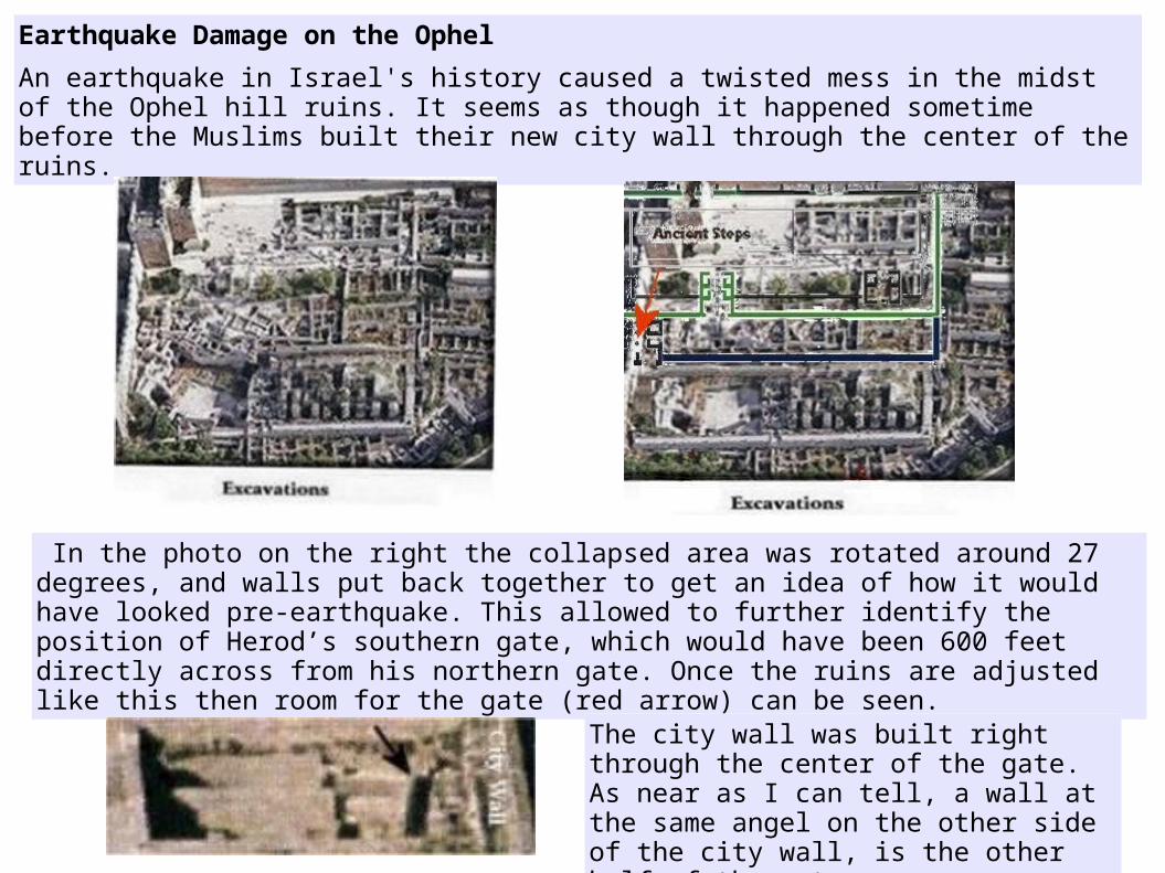
Earthquake Damage on the Ophel
An earthquake in Israel's history caused a twisted mess in the midst of the Ophel hill ruins. It seems as though it happened sometime before the Muslims built their new city wall through the center of the ruins.
In the photo on the right the collapsed area was rotated around 27 degrees, and walls put back together to get an idea of how it would have looked pre-earthquake. This allowed to further identify the position of Herod’s southern gate, which would have been 600 feet directly across from his northern gate. Once the ruins are adjusted like this then room for the gate (red arrow) can be seen.
The city wall was built right through the center of the gate. As near as I can tell, a wall at the same angel on the other side of the city wall, is the other half of the gate.
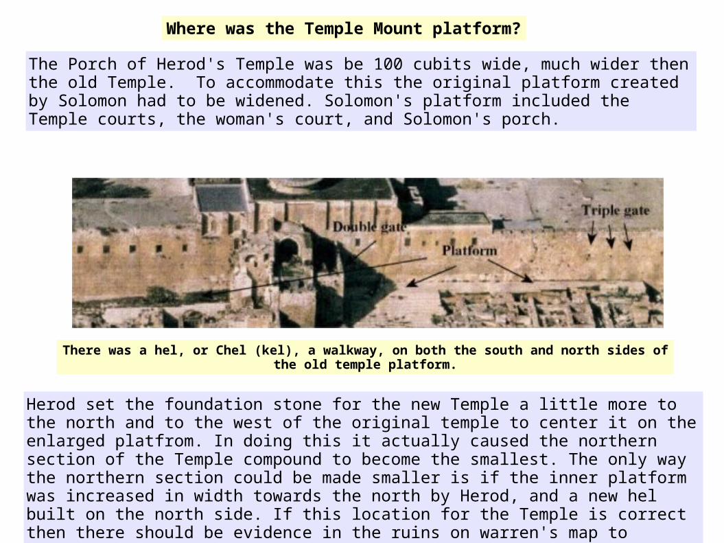
The Porch of Herod's Temple was be 100 cubits wide, much wider then the old Temple. To accommodate this the original platform created by Solomon had to be widened. Solomon's platform included the Temple courts, the woman's court, and Solomon's porch.
Where was the Temple Mount platform?
There was a hel, or Chel (kel), a walkway, on both the south and north sides of the old temple platform.
Herod set the foundation stone for the new Temple a little more to the north and to the west of the original temple to center it on the enlarged platfrom. In doing this it actually caused the northern section of the Temple compound to become the smallest. The only way the northern section could be made smaller is if the inner platform was increased in width towards the north by Herod, and a new hel built on the north side. If this location for the Temple is correct then there should be evidence in the ruins on warren's map to confirm it.

Warren shows the northeast corner of the Triple gate halls, which would have been the Northeast corner of the old platform. I marked out the size of Solomon's platform in red dashed lines. In this map we can see that Solomon's inner gates, and the north and south hels were within the perimeters of the old platform.
However Herod's gates were larger and goes beyond the platform. Notice that the western hall ends with what looks like a nipple. It is actually where an arch of a gate would have been and was partially dug into creating a nook. Amazingly the nook fit perfectly into the opening in Herod's northern inner gate.

Two red lines show how much the platform was increased to the North, including a new hel on the north of it . About 20 cubits at a regular Hebrew cubit. This decreases the northern section of the compound making it the smallest of the outer courts.
The Mishna says the southern section of the Temple compound had the most "open space", then the women's court, followed by the northern section, which had the least amount of open space.

Remember that Herod the Great built the Temple and upper courts and gates, but the walls of his extended compound were added after his death and were not totally complete until 66 CE. This would mean that the old walls of Solomon's temple remained standing, for the protection of the new temple. So when it is said that, the northern section was decreased in size by Herod, they were speaking about the compound within Solomon's old walls, not Herod's extended compound.
Can this also be shown through the ruins? Perhaps it can. Notice the eastern passage of double halls, the one that extends further north, ends as if going through a gate opening and then circles out like digging into the ruins of a room.
So what was the room they dug into? It would have been the ruins of Solomon's old north gate. This means the old north and south gates were rebuilt and incorporated into Herod’s design.
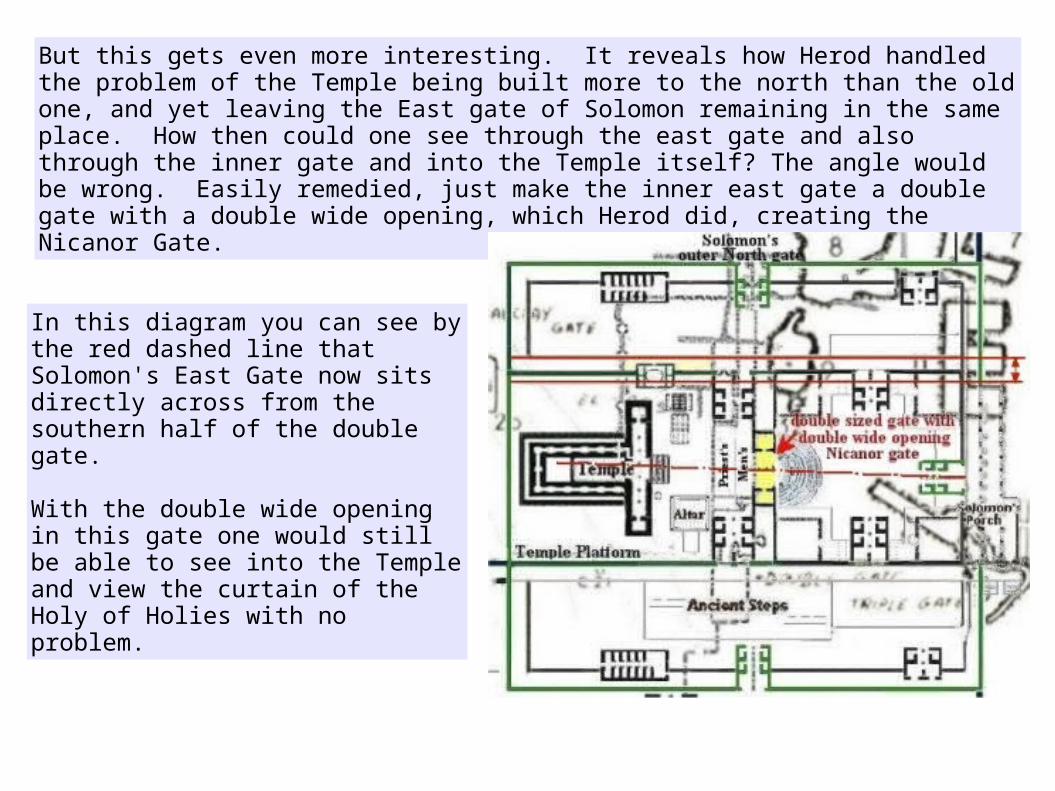
But this gets even more interesting. It reveals how Herod handled the problem of the Temple being built more to the north than the old one, and yet leaving the East gate of Solomon remaining in the same place. How then could one see through the east gate and also through the inner gate and into the Temple itself? The angle would be wrong. Easily remedied, just make the inner east gate a double gate with a double wide opening, which Herod did, creating the Nicanor Gate.
In this diagram you can see by the red dashed line that Solomon's East Gate now sits directly across from the southern half of the double gate.
With the double wide opening in this gate one would still be able to see into the Temple and view the curtain of the Holy of Holies with no problem.
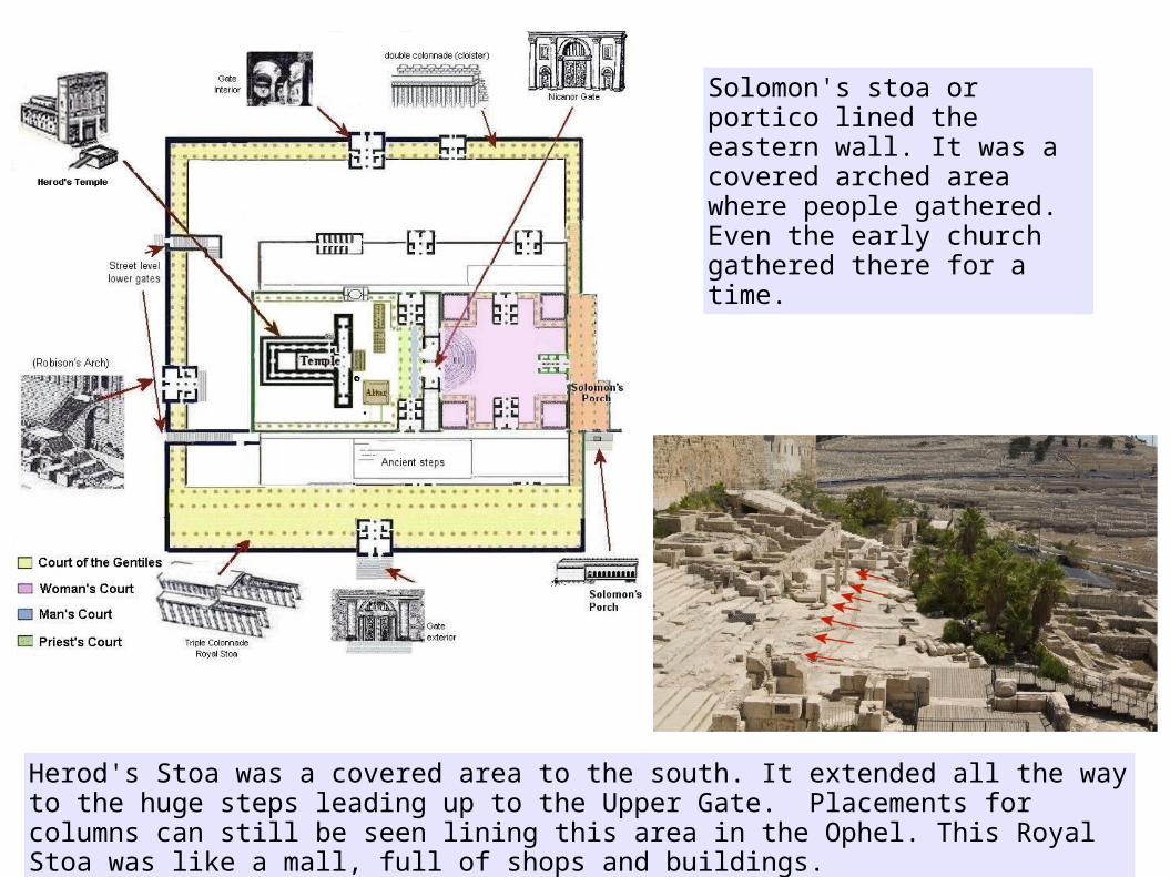
Herod's Stoa was a covered area to the south. It extended all the way to the huge steps leading up to the Upper Gate. Placements for columns can still be seen lining this area in the Ophel. This Royal Stoa was like a mall, full of shops and buildings.
Solomon's stoa or portico lined the eastern wall. It was a covered arched area where people gathered. Even the early church gathered there for a time.
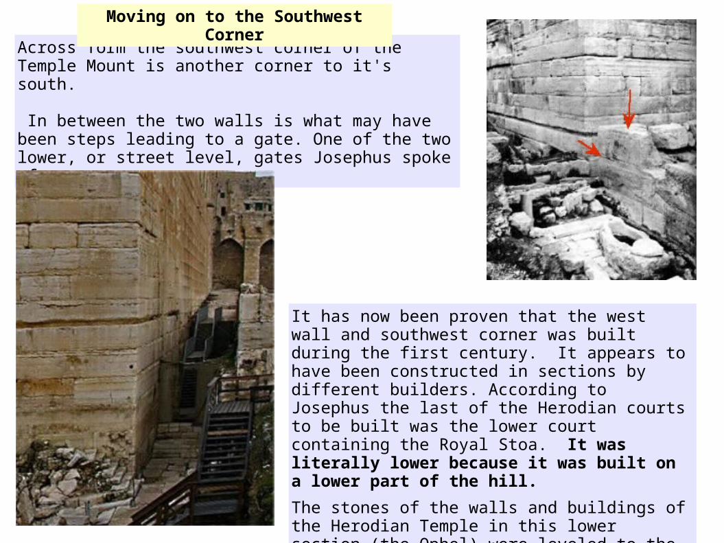
Across form the southwest corner of the Temple Mount is another corner to it's south.
In between the two walls is what may have been steps leading to a gate. One of the two lower, or street level, gates Josephus spoke of.
It has now been proven that the west wall and southwest corner was built during the first century. It appears to have been constructed in sections by different builders. According to Josephus the last of the Herodian courts to be built was the lower court containing the Royal Stoa. It was literally lower because it was built on a lower part of the hill.
The stones of the walls and buildings of the Herodian Temple in this lower section (the Ophel) were leveled to the ground and the materials re-used, but there is still a trace of this work among the ruins.
Moving on to the Southwest Corner

South of this second wall is the western half of the Ophel mound. Excavations revealed important data on the history of early Islamic Jerusalem. Four edifices, about 90 x 90 meters each, were unearthed and dated to the Umayyad period (7th-8th centuries CE).
This stopped the western half of the Ophel, in some of the areas, from being excavated down to the level of that on the eastern side.
This is how the western half today.
This whole area is now called the Ophel Archaeological Garden.
I hope you enjoyed this study on the Location of Solomon's Temple. God bless