the inventory of the historic city of sanaa a tool for urban conservation
TRANSCRIPT


The inventory of the historic city of Sana'aA tool for urban conservation
This publication was made possible with the support of theUNESCO/Italian Funds-in-Trust
Text and overall supervision: Daniele Pini
Design: Luca Lanzoni
Images: © UNESCODaniele Pini, Luca Lanzoni, Saveria Teston
Coordination: Franca MiglioliArab States Unit
UNESCO - World Heritage Centre
© UNESCO 2008
Printing: UNESCO Press, 2008
CLT-2008/WS/9
Content
Introduction
The Conservation of the Old City and the historic settlementsof Sana'a: a planning perspective
An overview of the past and recent conservation actionsNew threats from diffused and uncontrolled transformations
The lack of an appropriate planning and legal framework
The planning frameworkThe legislative frameworkThe "violations"
The need for a "Conservation and Rehabilitation Plan"
The "inventories"
The inventory of the Old City
The field surveyThe criteria of evaluationThe survey "handbook"
The inventoried buildings and open spaces (map page 59)
Building typologies in residential quarters (map page 60)
Suqs and commercial structures (map page 61)
Building height (map page 62)
Architectural layers and façade layout (map page 63)
Buildings architectural quality (map page 64)
Building ownership (map page 65)
State of occupancy (map page 66)
Use of street-level spaces in residential districts (map page 67)
The system of commercial activities (map page 68)
Cohabitation (map page 69)
Recent transformations (map page 70)
Repair of the Buildings (map page 71)
Repair of Open spaces (map page 72)
7
9
1315
21
212325
27
31
37
384245
5252525353545454555555565758

The extension of the Inventory to the historic suburbs of Bir AlAzab and Rawdah
The definition of the Protection PerimetersThe identification of the Survey zones for the InventoryThe field surveyThe criteria of evaluation
Bir Al Azab, Al Qaa - The inventoried buildings and open spacesBir Al Azab, Al Qaa - Typology of buildingsBir Al Azab, Al Qaa - OwnershipBir Al Azab, Al Qaa - Occupancy of buildingsBir Al Azab, Al Qaa - Functions of buildingsBir Al Azab, Al Qaa - CohabitationBir Al Azab, Al Qaa - State of repair
Rawdah - The Inventoried elementsRawdah - Typology of buildingsRawdah - Heritage interestRawdah - OwnershipRawdah - Occupancy of buildingsRawdah - Functions of buildingsRawdah - CohabitationRawdah - State of repair
Toward the Conservation and Rehabilitation Plan for the GreaterSana'a Historic Centre Conservation Plan
Guidelines from the InventoriesAn agenda for the preparation of the Plan
Bibliography
73
74778081
83848586878889
9091929394959697
99
101105
107
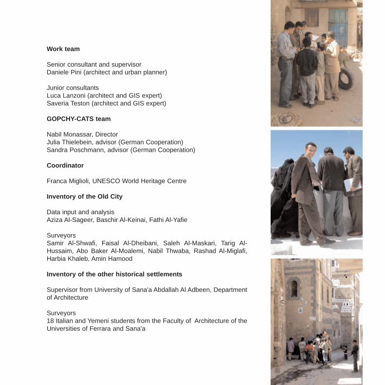
Work team
Senior consultant and supervisorDaniele Pini (architect and urban planner)
Junior consultantsLuca Lanzoni (architect and GIS expert)Saveria Teston (architect and GIS expert)
GOPCHY-CATS team
Nabil Monassar, DirectorJulia Thielebein, advisor (German Cooperation)Sandra Poschmann, advisor (German Cooperation)
Coordinator
Franca Miglioli, UNESCO World Heritage Centre
Inventory of the Old City
Data input and analysis Aziza Al-Sageer, Baschir Al-Keinai, Fathi Al-Yafie
Surveyors Samir Al-Shwafi, Faisal Al-Dheibani, Saleh Al-Maskari, Tarig Al-Hussaim, Abo Baker Al-Moalemi, Nabil Thwaba, Rashad Al-Miglafi,Harbia Khaleb, Amin Hamood
Inventory of the other historical settlements
Supervisor from University of Sana'a Abdallah Al Adbeen, Departmentof Architecture
Surveyors18 Italian and Yemeni students from the Faculty of Architecture of theUniversities of Ferrara and Sana'a
7
Introduction
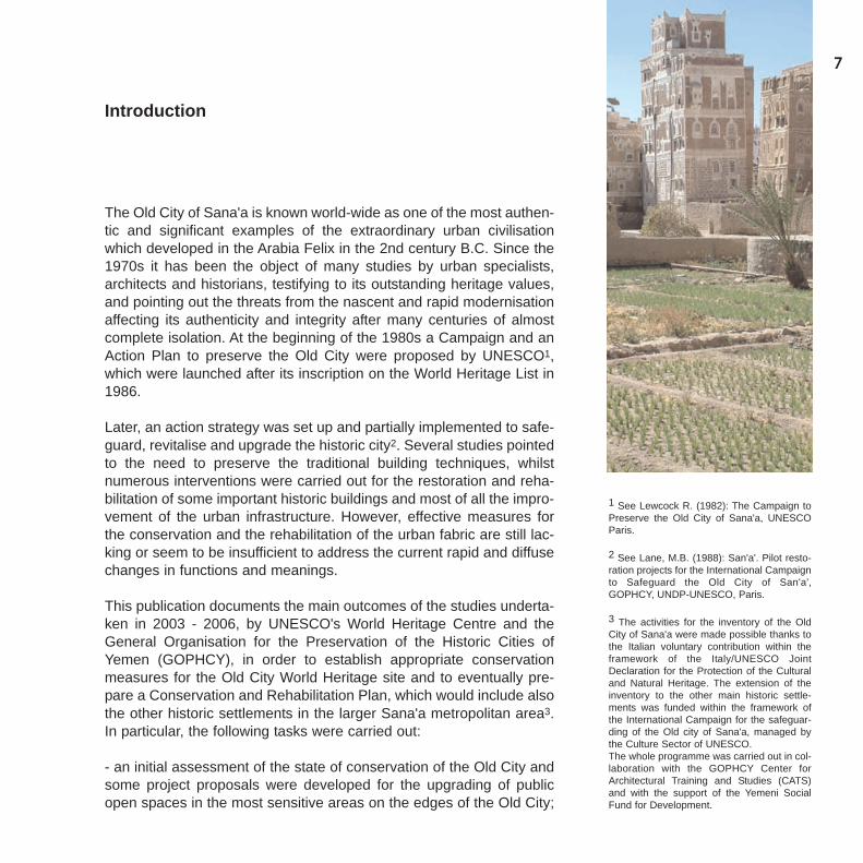
The Old City of Sana'a is known world-wide as one of the most authen-tic and significant examples of the extraordinary urban civilisationwhich developed in the Arabia Felix in the 2nd century B.C. Since the1970s it has been the object of many studies by urban specialists,architects and historians, testifying to its outstanding heritage values,and pointing out the threats from the nascent and rapid modernisationaffecting its authenticity and integrity after many centuries of almostcomplete isolation. At the beginning of the 1980s a Campaign and anAction Plan to preserve the Old City were proposed by UNESCO1,which were launched after its inscription on the World Heritage List in1986.
Later, an action strategy was set up and partially implemented to safe-guard, revitalise and upgrade the historic city2. Several studies pointedto the need to preserve the traditional building techniques, whilstnumerous interventions were carried out for the restoration and reha-bilitation of some important historic buildings and most of all the impro-vement of the urban infrastructure. However, effective measures forthe conservation and the rehabilitation of the urban fabric are still lac-king or seem to be insufficient to address the current rapid and diffusechanges in functions and meanings.
This publication documents the main outcomes of the studies underta-ken in 2003 - 2006, by UNESCO's World Heritage Centre and theGeneral Organisation for the Preservation of the Historic Cities ofYemen (GOPHCY), in order to establish appropriate conservationmeasures for the Old City World Heritage site and to eventually pre-pare a Conservation and Rehabilitation Plan, which would include alsothe other historic settlements in the larger Sana'a metropolitan area3.In particular, the following tasks were carried out:
- an initial assessment of the state of conservation of the Old City andsome project proposals were developed for the upgrading of publicopen spaces in the most sensitive areas on the edges of the Old City;
1 See Lewcock R. (1982): The Campaign toPreserve the Old City of Sana'a, UNESCOParis.
2 See Lane, M.B. (1988): San'a'. Pilot resto-ration projects for the International Campaignto Safeguard the Old City of San'a',GOPHCY, UNDP-UNESCO, Paris.
3 The activities for the inventory of the OldCity of Sana'a were made possible thanks tothe Italian voluntary contribution within theframework of the Italy/UNESCO JointDeclaration for the Protection of the Culturaland Natural Heritage. The extension of theinventory to the other main historic settle-ments was funded within the framework ofthe International Campaign for the safeguar-ding of the Old city of Sana'a, managed bythe Culture Sector of UNESCO.The whole programme was carried out in col-laboration with the GOPHCY Center forArchitectural Training and Studies (CATS)and with the support of the Yemeni SocialFund for Development.
- the preparation and the implementation of a detailed and exhaustiveinventory of the buildings and open spaces in the Old City of Sana'a,intended to establish protection measures, which was later extendedto the other main historic settlements of Bir-al- Azab and Rawdah;
- the proposal of a "Work Plan" for the establishment of a ConservationPlan for the historic settlements of the capital city.
Throughout the process, the concern for conservation has progressi-vely extended from the protection of the most significant monumentsand architectural features to the preservation and rehabilitation of theurban pattern, and from only the World Heritage site of Sana'a AlQadima to the historic settlements pattern in the wider metropolitanarea.
8
9
The conservation of the Old City and the historicsettlements of Sana'a: a planning perspective
New challenges for the conservation of the Old City
At the time of inscription on the World Heritage List in the 1980s, theOld City was declining and its heritage values were seriously threate-ned by the pressures of modernisation and rapid urbanisation. Now,increased attention must be paid by the institutions for its conservation,new issues have to be addressed, due to the dramatic changes occur-ring in the larger urban area. To this purpose, it is worth mentioningthat:
- the historic city is no longer a "city in itself" (an outstanding urbanfabric enclosed within its walls) but only a small though fundamentalentity within Greater Sana'a, which now probably represents less than1/30 - 1/40 of the overall urban population4. The Old City is subjectedto fast and considerable social changes - departure of the higher inco-me population, rural migration and increase of poverty - with wide-spread consequences on the housing stock tenure and the real estatemarket, which may imply a change of uses of both the built structuresand the open spaces (like the "bustans"). Hence, for instance, thetransformation of the historic "tower houses" into "apartment blocks" orthe development of new commercial activities, the decay of traditionalhandicraft techniques and the abandonment of historic structures likethe "samsarat"5. These social and economic changes are so relevantas to become key issues to be addressed by any conservation andrehabilitation policy;
- together with its "twin city" of Bir Al Azab, also known as the "Turkishquarter", the Old City represents the central core, both in geographicaland functional terms, of a fast growing metropolitan area. The sort of"Central Business District" that was developed in the sixties and theseventies in between and along the edges of the two cities, mainly inBir Al Azab, still provides the hinges where the main directions of urbangrowth coalesce and come in contact with the historic urban fabric. Butwhilst most government and administrative functions of the Capital are
4 The process was described by H.Eckert(1992): "The Chief Urban Functions of OldSana'a in the City of Sana'a Today": in theearly '90's the population of the Old City wasestimated at about 50.000 inhabitants,against 1 million in the Greater Sana'a area.According to other sources (see CulturalHeritage (Protection) Project, February 1999cited) the Old city population in 1999 wasabout 60000, whilst anecdotic informationfrom H. Eckert report the population ofSana'a to reach today 2,2 - 2,5 millions ofinhabitants.
5 As for the physical transformations relatedto these processes, see the doctoral thesis ofJ.P.Feiner (1997): "La vieille ville de Sana'a:analyse morphologique comme fondementde la sauvegarde patrimoniale", which offersa very rich base of information on the herita-ge conservation issues of the Old City, builton field surveys and observations.

accommodated in Bir Al Azab, the Old City's functional role seems tobe more strongly linked to the higher concentration of traditional retailand handicraft activities that mainly serve the increasing low-incomepopulation of the larger urban area rather than to the presence ofsocial facilities and cultural and religious institutions. A growing pres-sure in terms of activities and accessibility is being exerted on the "twincities", which is leading to an increasing divide of functions and activi-ties;
- on the other hand, the Old City is part of a larger historic urban andregional system, which has now been absorbed into the Sana'a metro-politan area, and not only includes Bir Al Azab but also other settle-ments such as Rawdah, with its remarkable pattern of residence buil-dings and gardens, linked to the Old City by the wadi valley landsca-pes, which used to be the week-end and summer resorts for Sana'a'srich families until 1965/19706, and other mountain villages like WadiDhar, with one of the most remarkable Royal Palaces in Yemen7,Hadda, Bayt Zapatan, Sana' and Bayt Boss. Together with the Old City,these historic settlements reflect different layers and aspects of thesame architectural and urban culture as Sana'a, and have beenseriously affected, though in different ways, by the ongoing process ofmodernisation and urbanisation.
10
6 In Rawdha many fine examples of Yemenitraditional architecture can be found thatcould be considered unique in manyrespects. Rawdha architecture is indeed amix of the traditional urban and countrysideSana'ani architecture, with gardens andorchards surrounding each palace or house.While in Sana'a the old city texture mainlyconsists of small and big palaces and housetowers, in Rawdha the palaces or towerhouses become a sort of country villa or man-sion, keeping the same architectural designsand profiles. The architecture of Rawdha is atribute to the zabur technique, mainly usedfor the ground and the first floor, while theremaining floors are built in baked bricks, butthe use of zabur for the entire building up to 3or 4 floors is also frequently found.
7 Wadi Dhar, site of the most famous Imampalace, the "Rock Palace", and one of themost beautiful green areas around the city, isconsidered a very important heritage site.Like in Rawdha, beautiful palaces or country-side villas are scattered along the wadi toge-ther with several old market places and smallvillages. Al Gheria is the biggest and mostimportant site along the wadi, with a rich heri-tage comprising an Imam palace and severalancient buildings. Here the architecture dif-fers from that of Rawdha or Sana'a but at thesame time keeping a strong relation.
Fig. 1 - The "twin cities" of Sana'a: the OldCity (right), still partially enclosed within theancient walls (thick blue line), and Bir Al Azab(left) whose fabric merges with the recenturbanisation on both sides of the ancientwalls, now demolished (red line).The newpattern of thoroughfares (yellow line) dividesthe two fabrics along the strip of the new"central business district" (violet), and sur-rounds the "twin cities", coalescing on theancient main roads (light blue lines) and hea-ding to the historic souk area (violet).

11
A comparison between the map of Rathjens and Wissmann of 1929and the most recent aerial photographs and maps of the mid 90smakes an initial appraisal of the degree of preservation and/or trans-formations of the historic urban patterns of the Old City and Bir Al Azabpossible.
As for the Old City, the partial demolition of the city walls can be noted,together with the appearance of new residential and commercial deve-lopments within and outside the former line of the walls. These mergewith the Bir Al Azab redevelopment to the west, where most of the poli-tical, administrative, and modern economic activities are located, andwith the new commercial and residential developments spreading inthe outskirts to the north and the south. If most of the ancient urbanpattern is still preserved in its integrity, the built fabric has nonethelessbeen affected by many scattered individual interventions - such as newconstructions in the bustans and gardens, and other kinds of wide-spread alterations that will be examined later.
In Bir Al Azab, transformations have been more radical, and have ledto the complete demolition of the city gates and walls, whose formerline is no longer visible, and to the overall densification of the remai-ning historic fabric, which was characterised by rich houses surroun-
Fig. 2 - Urban pattern transformations withinthe city walls of the Old City since 1930s.
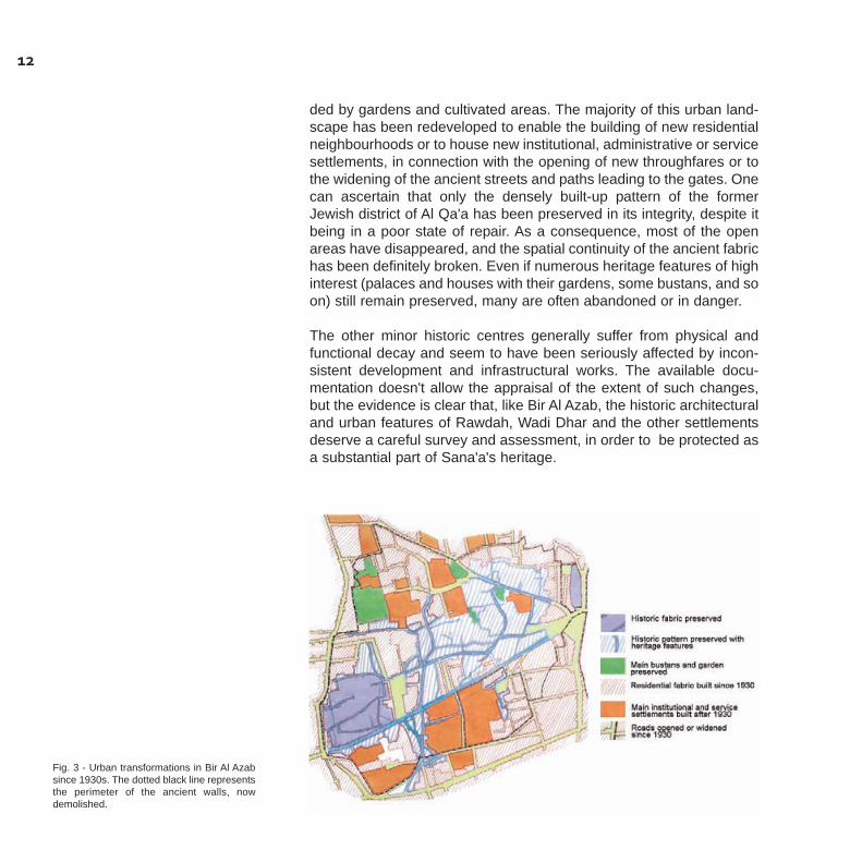
ded by gardens and cultivated areas. The majority of this urban land-scape has been redeveloped to enable the building of new residentialneighbourhoods or to house new institutional, administrative or servicesettlements, in connection with the opening of new throughfares or tothe widening of the ancient streets and paths leading to the gates. Onecan ascertain that only the densely built-up pattern of the formerJewish district of Al Qa'a has been preserved in its integrity, despite itbeing in a poor state of repair. As a consequence, most of the openareas have disappeared, and the spatial continuity of the ancient fabrichas been definitely broken. Even if numerous heritage features of highinterest (palaces and houses with their gardens, some bustans, and soon) still remain preserved, many are often abandoned or in danger.
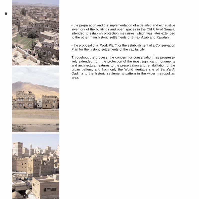
The other minor historic centres generally suffer from physical andfunctional decay and seem to have been seriously affected by incon-sistent development and infrastructural works. The available docu-mentation doesn't allow the appraisal of the extent of such changes,but the evidence is clear that, like Bir Al Azab, the historic architecturaland urban features of Rawdah, Wadi Dhar and the other settlementsdeserve a careful survey and assessment, in order to be protected asa substantial part of Sana'a's heritage.
12
Fig. 3 - Urban transformations in Bir Al Azabsince 1930s. The dotted black line representsthe perimeter of the ancient walls, nowdemolished.
13
An overview of the past and recent conservation actions
An initial assessment of the state of conservation of the World Heritageproperty - the Old City of Sana'a - highlights the new challenges for theconservation of this outstanding cultural heritage site within the broa-der context of the larger metropolitan area8.
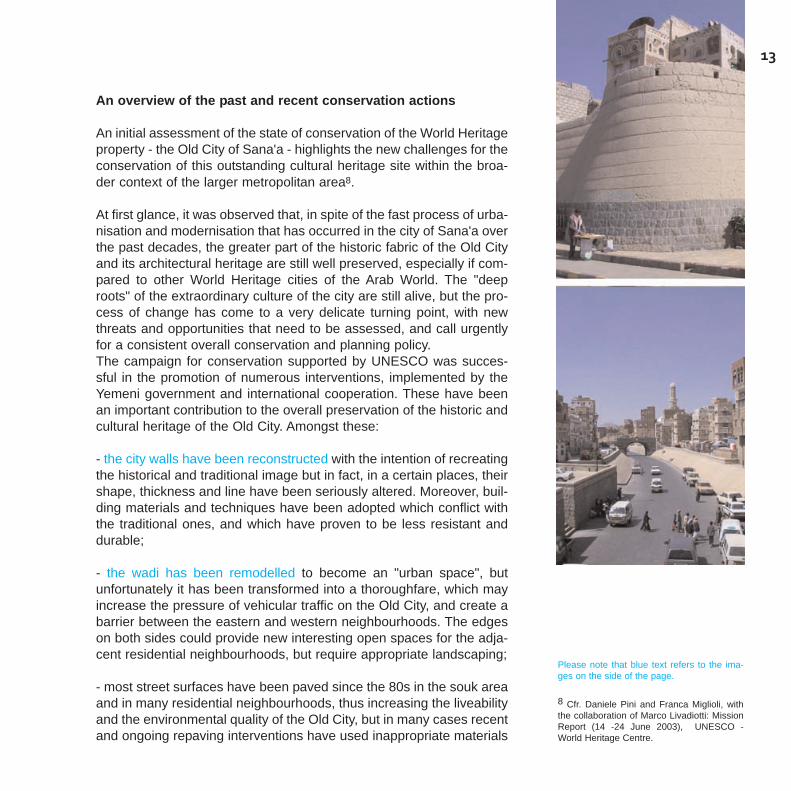
At first glance, it was observed that, in spite of the fast process of urba-nisation and modernisation that has occurred in the city of Sana'a overthe past decades, the greater part of the historic fabric of the Old Cityand its architectural heritage are still well preserved, especially if com-pared to other World Heritage cities of the Arab World. The "deeproots" of the extraordinary culture of the city are still alive, but the pro-cess of change has come to a very delicate turning point, with newthreats and opportunities that need to be assessed, and call urgentlyfor a consistent overall conservation and planning policy.The campaign for conservation supported by UNESCO was succes-sful in the promotion of numerous interventions, implemented by theYemeni government and international cooperation. These have beenan important contribution to the overall preservation of the historic andcultural heritage of the Old City. Amongst these:
- the city walls have been reconstructed with the intention of recreatingthe historical and traditional image but in fact, in a certain places, theirshape, thickness and line have been seriously altered. Moreover, buil-ding materials and techniques have been adopted which conflict withthe traditional ones, and which have proven to be less resistant anddurable;
- the wadi has been remodelled to become an "urban space", butunfortunately it has been transformed into a thoroughfare, which mayincrease the pressure of vehicular traffic on the Old City, and create abarrier between the eastern and western neighbourhoods. The edgeson both sides could provide new interesting open spaces for the adja-cent residential neighbourhoods, but require appropriate landscaping;
- most street surfaces have been paved since the 80s in the souk areaand in many residential neighbourhoods, thus increasing the liveabilityand the environmental quality of the Old City, but in many cases recentand ongoing repaving interventions have used inappropriate materials
Please note that blue text refers to the ima-ges on the side of the page.
8 Cfr. Daniele Pini and Franca Miglioli, withthe collaboration of Marco Livadiotti: MissionReport (14 -24 June 2003), UNESCO -World Heritage Centre.
and building techniques, and are not coordinated with infrastructureimprovement interventions;
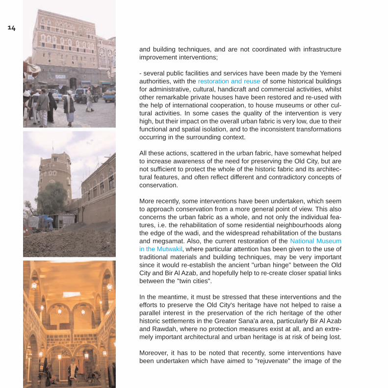
- several public facilities and services have been made by the Yemeniauthorities, with the restoration and reuse of some historical buildingsfor administrative, cultural, handicraft and commercial activities, whilstother remarkable private houses have been restored and re-used withthe help of international cooperation, to house museums or other cul-tural activities. In some cases the quality of the intervention is veryhigh, but their impact on the overall urban fabric is very low, due to theirfunctional and spatial isolation, and to the inconsistent transformationsoccurring in the surrounding context.
All these actions, scattered in the urban fabric, have somewhat helpedto increase awareness of the need for preserving the Old City, but arenot sufficient to protect the whole of the historic fabric and its architec-tural features, and often reflect different and contradictory concepts ofconservation.
More recently, some interventions have been undertaken, which seemto approach conservation from a more general point of view. This alsoconcerns the urban fabric as a whole, and not only the individual fea-tures, i.e. the rehabilitation of some residential neighbourhoods alongthe edge of the wadi, and the widespread rehabilitation of the bustansand megsamat. Also, the current restoration of the National Museumin the Mutwakil, where particular attention has been given to the use oftraditional materials and building techniques, may be very importantsince it would re-establish the ancient "urban hinge" between the OldCity and Bir Al Azab, and hopefully help to re-create closer spatial linksbetween the "twin cities".
In the meantime, it must be stressed that these interventions and theefforts to preserve the Old City's heritage have not helped to raise aparallel interest in the preservation of the rich heritage of the otherhistoric settlements in the Greater Sana'a area, particularly Bir Al Azaband Rawdah, where no protection measures exist at all, and an extre-mely important architectural and urban heritage is at risk of being lost.
Moreover, it has to be noted that recently, some interventions havebeen undertaken which have aimed to "rejuvenate" the image of the
14
15
Old City but which strongly contradict any acceptable concept of con-servation. These are:
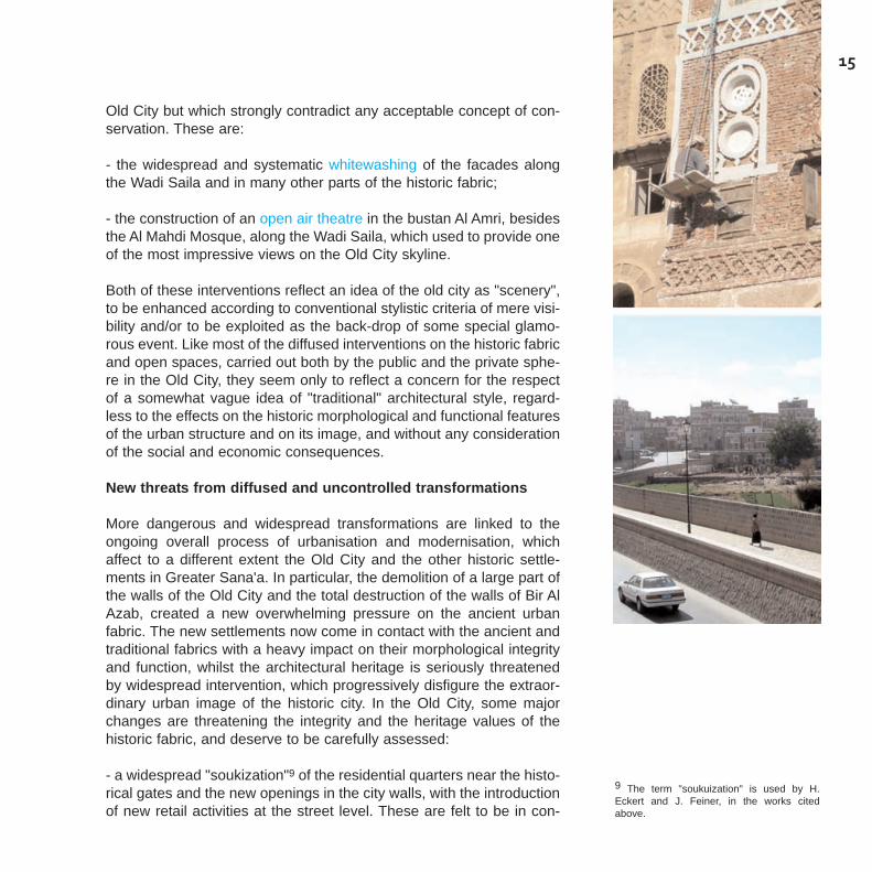
- the widespread and systematic whitewashing of the facades alongthe Wadi Saila and in many other parts of the historic fabric;
- the construction of an open air theatre in the bustan Al Amri, besidesthe Al Mahdi Mosque, along the Wadi Saila, which used to provide oneof the most impressive views on the Old City skyline.
Both of these interventions reflect an idea of the old city as "scenery",to be enhanced according to conventional stylistic criteria of mere visi-bility and/or to be exploited as the back-drop of some special glamo-rous event. Like most of the diffused interventions on the historic fabricand open spaces, carried out both by the public and the private sphe-re in the Old City, they seem only to reflect a concern for the respectof a somewhat vague idea of "traditional" architectural style, regard-less to the effects on the historic morphological and functional featuresof the urban structure and on its image, and without any considerationof the social and economic consequences.
New threats from diffused and uncontrolled transformations
More dangerous and widespread transformations are linked to theongoing overall process of urbanisation and modernisation, whichaffect to a different extent the Old City and the other historic settle-ments in Greater Sana'a. In particular, the demolition of a large part ofthe walls of the Old City and the total destruction of the walls of Bir AlAzab, created a new overwhelming pressure on the ancient urbanfabric. The new settlements now come in contact with the ancient andtraditional fabrics with a heavy impact on their morphological integrityand function, whilst the architectural heritage is seriously threatenedby widespread intervention, which progressively disfigure the extraor-dinary urban image of the historic city. In the Old City, some majorchanges are threatening the integrity and the heritage values of thehistoric fabric, and deserve to be carefully assessed:
- a widespread "soukization"9 of the residential quarters near the histo-rical gates and the new openings in the city walls, with the introductionof new retail activities at the street level. These are felt to be in con-
9 The term "soukuization" is used by H.Eckert and J. Feiner, in the works citedabove.

trast with the traditional sense of habitation of the Sana'ni residents.This induces a dangerous physical and functional decay in the resi-dential neighbourhoods, which is also related to the migration of highlevel income households outside of the Old City and to the rental of thepremises to many different lower income newcomers and households;
- important transformations occur in the central souk area, with wide-spread vertical additions to the existing buildings, inappropriate shel-ters and street furniture, as well as the decay of some relevant tradi-tional typologies, i.e.; most of the samsarat (caravanserai) have beenabandoned or converted to storage or retail uses; fountains and wells,which were a substantial part of the urban water supply system, havebeen abandoned or demolished;
- on the other hand, the residential fabric is being subjected to scatte-red but widespread transformations aiming at improving living stan-dards, and/or bound to the pressure of an increasing housing demand.These result in the following; new vertical (often 2 and more floors) andsometimes horizontal additions to the existing buildings; the demolitionand reconstruction of existing buildings; the construction of new buil-dings that reduce the extent of open spaces and damage the bustansand gardens which represent an integral part of the historic fabric (seephoto below);
- these changes are compounded by the spread of a kind of "neo-tra-ditional" architectural style, with the use of the "mafraj" type of ope-nings on all floors, the exaggerated use of decoration, and otheralmost caricature-like details;
- the occupation of green areas and gardens for the building not onlyof private houses but also of public facilities (like schools) which resultin an improper densification of the historic fabric, and are often totallyinconsistent with the architectural features and the spatial or functionalstructure of the Old City. This is particularly the case with the ongoingrealisation by a private developer of a wide market area with shelteredstalls in the Bustan Ingad, near the Bustan Al-Sultan area, which isgoing to compromise one of the potentially most valuable landscapefeatures along the Wadi Sailah , where one finds the most beautifulskylines of the Old City;
16
17
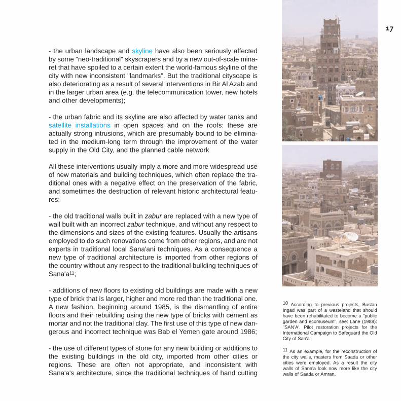
- the urban landscape and skyline have also been seriously affectedby some "neo-traditional" skyscrapers and by a new out-of-scale mina-ret that have spoiled to a certain extent the world-famous skyline of thecity with new inconsistent "landmarks". But the traditional cityscape isalso deteriorating as a result of several interventions in Bir Al Azab andin the larger urban area (e.g. the telecommunication tower, new hotelsand other developments);
- the urban fabric and its skyline are also affected by water tanks andsatellite installations in open spaces and on the roofs: these areactually strong intrusions, which are presumably bound to be elimina-ted in the medium-long term through the improvement of the watersupply in the Old City, and the planned cable network
All these interventions usually imply a more and more widespread useof new materials and building techniques, which often replace the tra-ditional ones with a negative effect on the preservation of the fabric,and sometimes the destruction of relevant historic architectural featu-res:
- the old traditional walls built in zabur are replaced with a new type ofwall built with an incorrect zabur technique, and without any respect tothe dimensions and sizes of the existing features. Usually the artisansemployed to do such renovations come from other regions, and are notexperts in traditional local Sana'ani techniques. As a consequence anew type of traditional architecture is imported from other regions ofthe country without any respect to the traditional building techniques ofSana'a11;
- additions of new floors to existing old buildings are made with a newtype of brick that is larger, higher and more red than the traditional one.A new fashion, beginning around 1985, is the dismantling of entirefloors and their rebuilding using the new type of bricks with cement asmortar and not the traditional clay. The first use of this type of new dan-gerous and incorrect technique was Bab el Yemen gate around 1986;
- the use of different types of stone for any new building or additions tothe existing buildings in the old city, imported from other cities orregions. These are often not appropriate, and inconsistent withSana'a's architecture, since the traditional techniques of hand cutting
10 According to previous projects, BustanIngad was part of a wasteland that shouldhave been rehabilitated to become a "publicgarden and ecomuseum", see: Lane (1988):"SAN'A'. Pilot restoration projects for theInternational Campaign to Safeguard the OldCity of San'a".
11 As an example, for the reconstruction ofthe city walls, masters from Saada or othercities were employed. As a result the citywalls of Sana'a look now more like the citywalls of Saada or Amran.

and finishing are not respected. Moreover the widespread use ofmachine cutting creates a strong contrast with the historic heritage fea-tures;
- the opening of new commercial activities or the modernisation of thetraditional ones which usually implies the replacement of most of thetraditional wooden doors with steel doors;
- the total destruction of all traditional zabur fencing walls surroundingthe gardens and yards or along the alleys of the old city, which werean important element of the traditional urban texture, to be replaced bystone fencing. This started mainly with the renovation campaign for thegardens of Old Sana'a around 4 years ago;
Beside the Old City, due to lack of any kind of protection, Bir Al Azabis becoming a congested "modern" district, with a more and more ordi-nary urban image, in spite of its important central functions and facili-ties. In particular, the integrity and continuity of historic urban patternand fabric has been inquestionably affected, by the following transfor-mations:
- the city walls and gates have been completely demolished and theancient urban fabric now melds with the modern urbanisation withoutany break or spatial separation;
- the historic fabric is being deeply and widely transformed not only byan overall densification of the urban pattern, but also by several scat-tered redevelopment projects or re-use interventions of old houses andgardens;
- most of the bustans and other green areas are disappearing not onlyas a result of recent residential developments, but also due to the con-struction of many institutional buildings, public facilities, tourist andcommercial developments, with no respect for the historic pattern.
Due to the present zoning regulations and/or to the lack of any meas-ure of protection, several commercial and residential buildings havebeen built that create a strong contrast with the remaining historicfabric, in their height and typological characteristics, despite theirattempts to imitate the so-called "traditional style" of the Sana'ani
18

19
architecture. Moreover, the same diffused interventions as in the OldCity can be found, that disfigure the remaining heritage urban fabricand buildings:
- the residential fabric is particularly affected by an uncontrolled pro-cess of "modernisation", which implies demolitions and reconstruc-tions, vertical and/or horizontal additions, and all kinds of transforma-tions of the existing structures;
- almost all the green spaces and gardens have been occupied notonly by private houses but also by hotels and, above all, administrati-ve buildings (like Ministries and Embassies). These are often totallyinconsistent with the architectural features and the spatial or functionalstructure of historic Bir al-Azab, and result in an intense densificationof the urban fabric;
- as in Old Sana'a, the use of different types of stone for any new buil-ding, urban feature or additions to the existing buildings in Bir al-Azab,imported from other cities or regions and often inconsistent withSana'ani architecture.
- the urban landscape and skyline have also been seriously affectedby some modern skyscrapers and towers;
- public and private open spaces have been abandoned and few ofthem are still cultivated. This means that the elements necessary forirrigation (Bir and Marnah) are also disused;
- a lot of traditional zabur fencing walls surrounding gardens andbustans, which were an important element of the traditional urbanfabric, have been destroyed or replaced using inconsistent materials.
As for Rawdah, if the ancient settlement pattern is still largely intact,the integrity of the urban fabric is threatened by fast-growing moderndevelopments. Moreover, many scattered redevelopment interventionsare disfiguring the ancient fabric with the demolition of important heri-tage features, whilst many historic buildings and gardens are abando-ned or in bad repair:
- almost the whole traditional souk area has been deskapeel, losing its
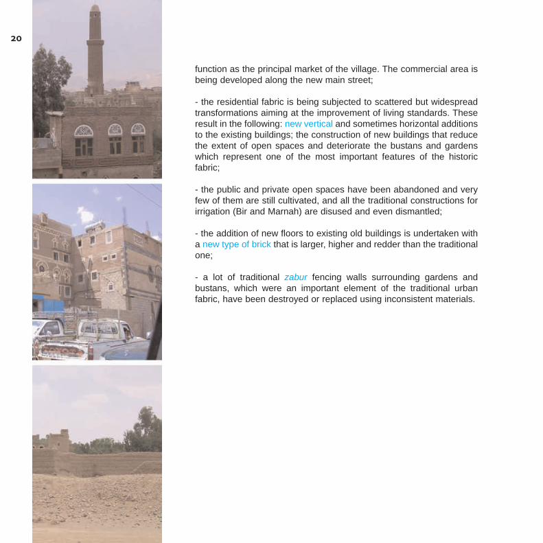
function as the principal market of the village. The commercial area isbeing developed along the new main street;
- the residential fabric is being subjected to scattered but widespreadtransformations aiming at the improvement of living standards. Theseresult in the following: new vertical and sometimes horizontal additionsto the existing buildings; the construction of new buildings that reducethe extent of open spaces and deteriorate the bustans and gardenswhich represent one of the most important features of the historicfabric;
- the public and private open spaces have been abandoned and veryfew of them are still cultivated, and all the traditional constructions forirrigation (Bir and Marnah) are disused and even dismantled;
- the addition of new floors to existing old buildings is undertaken witha new type of brick that is larger, higher and redder than the traditionalone;
- a lot of traditional zabur fencing walls surrounding gardens andbustans, which were an important element of the traditional urbanfabric, have been destroyed or replaced using inconsistent materials.
20
21
The lack of an appropriate planningand legal framework
One of the main obstacles to the conservation of the Old City and itshistoric suburbs was the absence of an appropriate planning and legalframework, which seriously hampered and made almost ineffective theaction of the concerned institutions, particularly the GeneralOrganisation for the Preservation of the Historic Cities of Yemen(GOPHCY).
The planning framework
A Master Plan was prepared in the late 70s, based on projectionsincreasing the population from 160.000 inhabitants in 1977 to 985.000for the year 2000 and the density from 55 persons/hectare to 96. Ifthese projections were largely underestimated, the Master Plan hasnonetheless provided the general layout of eventual urban growth. Themain emphasis has been put on the construction of a new larger roadnetwork that was intended to form the backbone of the future expan-sions and/or of the redevelopment of the existing urban areas. Themain orientation of city growth was to the North and to the South, dueto the topographic constraints existing to the East and the West. Thiskept the whole of the historic "twin cities" of old Sana'a Al Qadima andBir al Azab as the fundamental hinge of the rapidly growing urbanstructure, whilst Rawdah was to be merged in the new urbanisationdeveloping to the north towards the airport and beyond. Among "deve-lopment sectors" which were identified "to distribute future develop-ment of the city", the following concerned the historic city and itsvarious parts:
- the "medina", encompassing the "Old Town" and the "Souk" where,according to the land use information available in 1977, the developedland represented 57% of the area. The existing population of 73.000inhabitants was to increase up to 137.000 in the year 2000 through"infill" developments which were expected to cover the remainingundeveloped land;
- the Abdul Moghni sector, east of the "medina", encompassing therecently developed "central business district" along Nasser street andAli Abdul Moghni street, and the historic fabric of Bir Al Azab, where thedeveloped land represented 48% of the area. The planned develop-ment would have covered 93% of the area by the year 2000, allowingfor a population increase from 46.500 inhabitants to 179.200;
- Rawdah, a sector substantially undeveloped in 1977 (only 9% of thearea was developed) which included the "residential neighbourhoods"of the historic centre (considered as "particularly notable as they con-tain outstanding examples of Yemeni architecture"). Development herewas planned to cover 76% of the area, with the population increasingfrom 8.900 inhabitants to 165.800.
In this framework, some "program objectives" were proposed regar-ding the historic fabrics, namely:
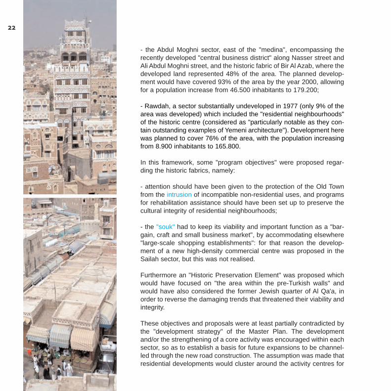
- attention should have been given to the protection of the Old Townfrom the intrusion of incompatible non-residential uses, and programsfor rehabilitation assistance should have been set up to preserve thecultural integrity of residential neighbourhoods;
- the "souk" had to keep its viability and important function as a "bar-gain, craft and small business market", by accommodating elsewhere"large-scale shopping establishments": for that reason the develop-ment of a new high-density commercial centre was proposed in theSailah sector, but this was not realised.
Furthermore an "Historic Preservation Element" was proposed whichwould have focused on "the area within the pre-Turkish walls" andwould have also considered the former Jewish quarter of Al Qa'a, inorder to reverse the damaging trends that threatened their viability andintegrity.
These objectives and proposals were at least partially contradicted bythe "development strategy" of the Master Plan. The developmentand/or the strengthening of a core activity was encouraged within eachsector, so as to establish a basis for future expansions to be channel-led through the new road construction. The assumption was made thatresidential developments would cluster around the activity centres for
22
accessibility to employment and shopping facilities, whilst the "high-intensity cores" would continue to expand, so that the general urbandevelopment would have occurred on the fringes of the concentratedareas. As a result:
- new residential areas were developed in the open areas within thecity walls of both the Old City and Bir Al Azab. Fortunately, the deve-lopments within the Old City walls have had a lesser effect than hadbeen expected and most of the bustans and megsamat have been pre-served;
- a new road network has been created through the widening of exist-ing streets and the construction of new ones in the historic fabrics,especially in Bir Al Azab, to facilitate traffic and car access within resi-dential neighbourhoods;
- the commercial and business activities have been reinforced on theedges of the Old City, especially in connection with the main entrancesof Bab Shu'ub, and Bab el Yemen, along Ali Abdul Moghni street, allover the ancient fabric of Bir Al Azab and its outskirts, and to a lesserextent in Rawdah.
The legislative framework
These developments occurred without any specific conservationmeasure for the historic fabric of the suburbs, whilst the Old City peri-meter was submitted to legal protection by decree no. 17/1994 con-cerning the "General Provisions for Violations", and a decree issued bythe Prime Minister, no. 204/2001 regarding "Regulations forConstructions and Violations in the Historical Cities".
Though without the power of a law, the Decree 204/2001 provides forlegislative tools aimed at the "preservation and protection of historicalcities, landmarks and sites" as well as "buildings and their historicaland cultural style", preventing "assaults and works of destruction anddemolition and construction works that use non-traditional materialsnot allowed by the General Organisation for the Preservation of theHistorical Cities". It defines very strict conditions for any type of con-struction and gives the GOPHCY a crucial role in the control of buildingactivity. Moreover a list of conditions and controls is provided, which
23

have to be ensured in order to legitimate building renovation and dem-olition works. These include:
- the use of "traditional building materials" and the conformity to the"general pattern of the historical cities": if these conditions are not ful-filled, works must be stopped;
- the preservation of existing open spaces between buildings, as wellas of the "green" and cultivated areas, "which form an important con-stituent of the historical cities";
- the conservation of the existing functions of "historical buildings andlandmarks", and the prevention of any uses "that may be hazardous tothese structures or make them lose their original style or properties".The "distinctive features and the peculiar activities of the traditionalmarkets should be preserved", and the "opening of new commercialoutlets in the residential areas …, which are set up by the GOPCHY,should be stopped";
- the suspension of any new and additional work that changes thehistorical elements and the architectural style of historical buildings.
The Decree also provides a detailed list of prohibited activities, whichinclude amongst others:
- additional or annexed constructions to an existing building, including"vertical and horizontal expansions … if such works will alter the archi-tectural style of a historical city";
- any kind of intervention that may imply the direct or indirect "demoli-tion, expunction, deformation, alteration or damage to the historicalcities and sights", including "engravings and decorations that are foundon the buildings";
- the construction of new buildings attached to historical buildings, ele-ments or landmarks, as well as in the religious areas, in public areas,in "white" open and cultivated areas: the uprooting of trees and the useof the areas for disposing of waste or garbage is also prohibited;
- the creation of new commercial outlets in the residential areas and
24
"the alteration of the function of a building or any part thereof" withoutwritten approval of the GOPHCY;
- the use of building materials which do not conform to traditionalapproaches such as "reinforced concrete, iron doors in lieu of woodendoors or use of aluminium windows in lieu of wooden windows, etc.",as well as "scraping red bricks or covering thereof with defacing mate-rials such as paints, etc.".
The "violations"
A survey was carried out by GOPHCY during the period July 2002 -February 2003 to identify the "violations" committed according to theabove decree, with a team formed by technicians of different involvedparties (such as Public Works, Local Councils and Awaqf) speciallyappointed under the direction of GOPHCY. The following types of vio-lations were identified:
- the use of different building materials and techniques not conformingto the traditional and historical architecture;- the construction of new buildings on open and public spaces;- the opening of new commercial outlets;- additions (mainly vertical) to existing buildings.
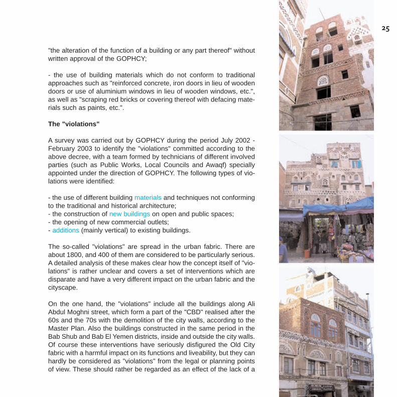
The so-called "violations" are spread in the urban fabric. There areabout 1800, and 400 of them are considered to be particularly serious.A detailed analysis of these makes clear how the concept itself of "vio-lations" is rather unclear and covers a set of interventions which aredisparate and have a very different impact on the urban fabric and thecityscape.
On the one hand, the "violations" include all the buildings along AliAbdul Moghni street, which form a part of the "CBD" realised after the60s and the 70s with the demolition of the city walls, according to theMaster Plan. Also the buildings constructed in the same period in theBab Shub and Bab El Yemen districts, inside and outside the city walls.Of course these interventions have seriously disfigured the Old Cityfabric with a harmful impact on its functions and liveability, but they canhardly be considered as "violations" from the legal or planning pointsof view. These should rather be regarded as an effect of the lack of a
25
"buffer" zone, and a major planning issue to be addressed in a futureconservation and rehabilitation policy.On the other hand, no clear distinction is made between the new con-structions and the reconstruction of pre-existing buildings: the "viola-tions" are recorded only with reference to the use of wrong materialsapparently without any concern for the scale of the interventions or thefunctions of the building.
Nonetheless, the survey and registration of the "violations" is an impor-tant step towards an increased awareness of the Old City protectionissues, and could represent an important contribution to a more consi-stent conservation and rehabilitation policy.
26
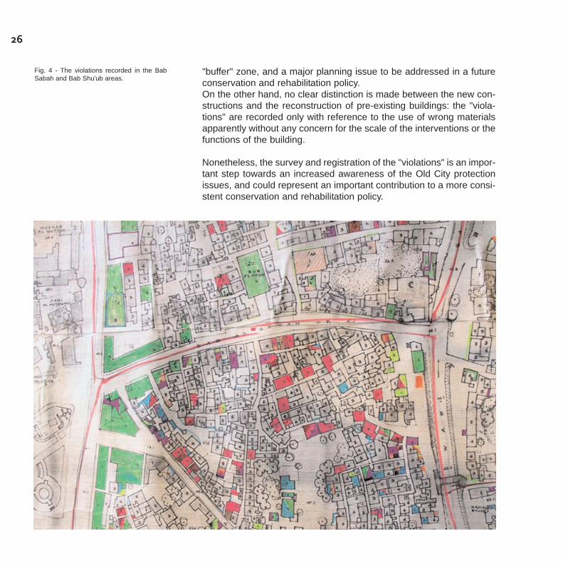
Fig. 4 - The violations recorded in the BabSabah and Bab Shu'ub areas.

As a conclusion of this overview, it is evident that a conservation policycan not be based only on "projects" carried out by public authorities orby international cooperation, though ambitious and widespread withinthe urban fabric. The restoration of specifically important monumentsor architectural complexes, or the improvement of the urban infra-structure may become effective for the conservation of the historicfabric and its heritage values only if a more general regulatory andplanning framework is established and enforced to control the processof modernisation. This process is changing the role and the meaningof the Old City and its suburbs in the context of intense urbanisation.
A new planning approach addressing these issues should consider thehistoric heritage of the different urban fabrics not as a "constraint" tomodernisation but as a "resource" for a more sustainable urban deve-lopment - an asset to be preserved not only to keep alive the "deeproots" of the city's cultural identity, but also to promote activities whichcan improve the economic and social condition of its inhabitants.
A "Conservation and Rehabilitation Plan" has to be established, basedon a broader concept of "heritage", which includes not only the"monuments" and the "remarkable buildings", but also their context,with the "minor" and "vernacular" architectural expressions, the articu-lation of the urban spaces, landscape features, according to the mostadvanced international "state of art" in planning. Obviously, this herita-ge can only be preserved if life is able to remain a part of it, and if thefunctions and meanings which are favoured are compatible with itscharacteristics, through the "adaptive" reuse of its various features.
Conservation has therefore to be associated with "rehabilitation", andthe Plan has to provide tools for protecting the heritage features fromfurther deterioration, while favouring at the same time all the possiblecompatible interventions in the Old City (and in the other historic sett-lements), which can improve the living conditions of the population andbring new activities and uses. To this purpose, it is essential to create
27
The need for a "Conservation and Rehabilitation Plan"
the conditions for making conservation planning effective. On onehand, it is necessary to improve and develop a cultural, legislative andinstitutional framework, which suffers from:
- the lack of awareness, and the presence of different and contrastingconcepts on conservation amongst authorities and public opinion;- the lack of legal tools for an overall heritage classification and pro-tection;- the overlapping of powers and responsibilities, and the lack of insti-tutional capacities and technical skills.
On the other hand, it is necessary to set up an "incremental" planningprocess, to be implemented gradually through a well-coordinatedsequence of regulatory measures, strategic projects and studies onthe most relevant issues that may affect the preservation of the OldCity, and also of the other historic centres in the Greater Sana'a metro-politan area. It would be harmful indeed to preserve only a part of the"deep roots" and to let the rest be destroyed or indefinitely disfigured.The lack of awareness and vision relating to the protection of Sana'niheritage is probably the most important issue to be addressed in orderto set-up a consistent and successful conservation and rehabilitationpolicy. Moreover the concept that heritage is merely a matter of "anti-quities" or individual monuments and outstanding sites to be preservedfor their "aesthetic" characteristics, regardless of their broader culturalmeaning and socio-economic context is widespread. Therefore herita-ge protection is sometimes considered to be a "subjective" require-ment of "cultural" circles, which has to withdraw in front of the "objec-tive" needs of the "modernisation" and technical development. Thereseems to be little concern about heritage, and the role that its conser-vation and rehabilitation can play in ensuring a more sustainable urbandevelopment. Moreover, evidence on the ground and meetings held atGOPHCY and the other administrations also makes it clear that diffe-rent and sometimes contrasting approaches and visions exist, whenheritage conservation becomes a priority: no shared concepts andclear definitions exist of what should be considered as the "traditional"architectural style, or "traditional" buildings materials and techniques.
It is therefore essential to establish a clear definition of some conceptsand terms, in order to formulate general criteria and rules for interven-tion in the protected areas, in order to avoid a merely "aesthetic" con-
28
servation policy, and hence eliminate arbitrary interpretations, whichmay affect the decision-making process.
From this point of view, it is urgent to remove all the ambiguities of thedecree 204/2001 on "Violations" that refers to the perimeter of the OldCity, and which should therefore be extended to the other historic sett-lements in the metropolitan area of Sana'a. While it is important to notethat a "violation" exists only when an intervention occurs which con-flicts with the existing approved plans and regulations, concepts whichunderlie these terms should be defined. For example: the use of "tra-ditional building material"; conformity of works to the "general patternof the historical cities"; prevention of any uses "that may be hazardousto these structures or make them lose their original style or properties";"distinctive features" and "peculiar activities of the traditional markets"to be preserved, etc. In order to undertake a consistent conservationand rehabilitation policy a set of "actions" was proposed by the UNE-SCO World Heritage Centre, to be carried out in different phases,which can be summarised as follows:
Start-up phase
- complete and clarify the legal framework with the approval of theDraft Law for the Protection of Historic Cities and Draft Building Law,and the amendments to the decree relating to "violations";- undertake the creation of an appropriate institutional set-up to dealwith the preparation and the follow-up of the different regulatory andplanning actions, with the strengthening and the full empowerment ofGOPCHY;
Phase 1
- the realisation of a detailed inventory of built structures and open spa-ces in the Old City, using GIS techniques, to serve as an informationbaseline for the preparation of appropriate regulation to control thebuilding activities and for the establishment of a Conservation andRehabilitation Plan;- the establishment of temporary regulatory measures for the protec-tion of the historical architectural and urban features of the, on thebasis of the existing legislation on the "violations", including the identi-fication of "conservation areas", "buffer zones" and "no-build zones";
29
- the identification and the establishment of a protection perimeter forthe other historical settlements and areas to be preserved withinGreater Sana'a, to be declared as "historical cities" subject to the exist-ing legislation on "violations" and to an appropriate revision of theMaster Plan.
Phase 2
- the carrying out of the inventory of built structures and open spacesin the other historic settlements identified in the Greater Sana'a area,with the same techniques and methods used for the Old City (GIStechniques), in view of the establishment of specific protection meas-ures to be included in the Conservation and Rehabilitation Plan forSana'a;- the establishment and the gradual implementation of urban regene-ration, rehabilitation and conservation priority projects concerningsome crucial "sensitive areas", which have been already identified orcould be identified in the process.
Phase 3
- the preparation and establishment of a Conservation andRehabilitation Plan for the Old City, Bir Al Azab, Rawdah and the otherhistoric settlements of the Greater Sana'a area, to be integrated in thenew Master Plan as a tool for the preservation of the historical herita-ge within the framework of an overall urban development. TheConservation and Rehabilitation Plan should be based, on one hand,on the "inventories" carried out in the previous phases, and, on theother hand, on a series of studies intended to offer an accuratedescription of the current situation and an outline of the future trendsand issues to be addressed.
This programme of action should aim not only to prepare a plan, butmainly to start a sustainable and long-term planning process, in orderto ensure the continuous management of the outstanding Sana'a heri-tage asset, to be carried out by the Yemeni authorities, in close coope-ration with UNESCO.
30

31
The "inventories"
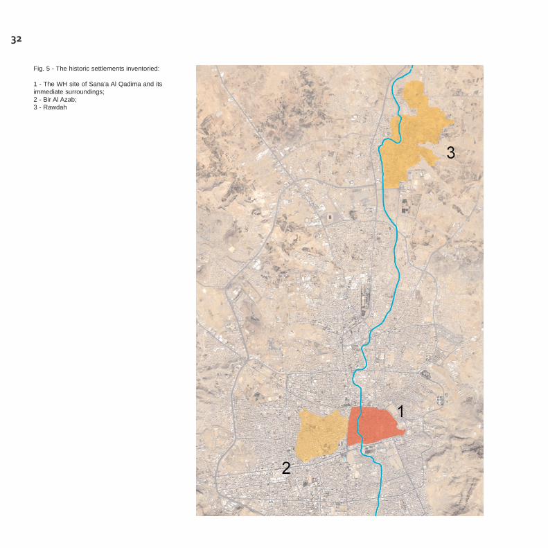
Together with the creation of an appropriate institutional set-up, theimplementation of an inventory of all the built structures and open spa-ces has been considered as the first, necessary step of a consistentconservation and rehabilitation policy to be enforced in the "protectionareas". In the framework of the technical assistance provided by UNE-SCO to the GOPHCY, the "inventories" were carried out for the OldCity of Sana'a12, inscribed in the World Heritage list since 1986, andthe two most important historical suburbs of Bir Al Azab and Rawdah13,whose protection was decided by the Yemeni Government by decreein September 2005.
In the framework of the procedures proposed for the establishment ofthe Conservation and Rehabilitation Plan, the implementation of theinventories is strictly related to the establishment of a non-arbitraryregulation, ensuring an effective control of the building activities for thesafeguard of the Old City and the historic suburbs, even before thefinal approval of the Plan. For this reason the inventories have beenextended to cover the historic and traditional fabric that were alreadyincluded in the protection area of Old Sana'a, and that were to be inclu-ded in the protection areas of Bir Al Azab and Rawdah.
The main goal of the inventories, at this stage, is to provide theGOPHCY and the other concerned administrations with a tool to con-trol and monitor building activities, as well as the overall physical andfunctional transformations which may affect the urban fabric of thehistoric city. The inventories are therefore intended to provide updatedand comprehensive information, which would help establish thedegrees of protection and to define the possible required interventions,thus giving the officials and the professionals of both the public and theprivate sectors a clear and solid base to plan and design the work tobe undertaken. It is believed that this will result not only in increasedcapacity for the protection of the architectural and urban heritage, butalso in a broader awareness of the values to be preserved and enhan-ced.
12 The inventory of the Old City of Sana'awas carried out in 2004-2006 by theGOPHCY under the guidance and supervi-sion of a team appointed by the UNESCO -World Heritage Centre, with funds from theItalian Cooperation and the Social Fund forDevelopment of the Yemeni Republic.
13 The Inventory of the buildings and openspaces in the historic centres of Bir Al Azaband Rawdah was conducted in 2005 as anextension of the Inventory undertaken for theOld City of Sana'a. A specific project wasprepared by UNESCO - CLT/CH, in collabo-ration with the Facoltà di Architettura of theUniversity of Ferrara and the Department ofArchitecture of the University of Sana'a.
32
Fig. 5 - The historic settlements inventoried:
1 - The WH site of Sana'a Al Qadima and itsimmediate surroundings;2 - Bir Al Azab;3 - Rawdah
33
The inventories are also to provide, in the longer term, the informationbase which is necessary to undertake the establishment of the propo-sed Conservation and Rehabilitation Plan, concerning the typology,the architectural and spatial values, as well as the physical and func-tional consistency of the urban and architectural heritage to be preser-ved within the different protection areas.
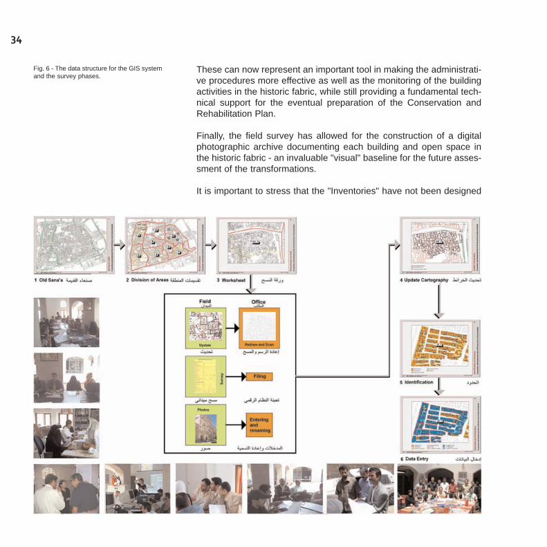
The information has been collected through direct observation andmapping by means of survey sheets14 specific to the different types ofheritage features, and organised into a database to be continuouslyupdated during the management and planning process. Thus theinventories have been designed so as to construct a GIS that could beused by the GOPHCY, and possibly by any other concerned admini-stration, to carry out the procedures for delivering the building permitsor the monitoring of the building activity, and would support in the futu-re the preparation and the evaluation of more complex and articulatedconservation policies.
It must be noted that the implementation of the inventories throughcomprehensive field surveys has allowed for the achievement of otherimportant objectives.
First and foremost, the working process - from the preparation of thefield survey to the data entry - has provided a unique opportunity todevelop a long-term program of "training on the job" of Yemeni stu-dents of Architecture and young architects, who were employed by theGOPHCY as surveyors and later on as technicians with growingresponsibilities. These included the ability to recognise and evaluateheritage components and values, and the use of electronic tools formapping and organising information.
In this framework, the construction of the GIS has required the prepa-ration of a detailed and reliable digitised base map of the Old City andthe two suburbs of Bir Al Azab and Rawdah, through the updating andthe correction of the available maps, dating from the 1980's and largelyunreliable to a great extent. Moreover, the information collectedthrough the filed survey allowed the construction of a data base con-cerning all the buildings and open spaces of the Old City and the heri-tage buildings in the two suburbs.
14 Due to the limited available resources,and consequently the very strict envisagedtime framework, only the features that mightbe observed from outside (streets, open spa-ces, roofs) have been surveyed. However thedefinite identification of each building, con-struction and open space would allow for afurther integration of the collected data withother type of information, i.e. concerning theinterior characteristics of the buildings, thehouseholds, and so on.
These can now represent an important tool in making the administrati-ve procedures more effective as well as the monitoring of the buildingactivities in the historic fabric, while still providing a fundamental tech-nical support for the eventual preparation of the Conservation andRehabilitation Plan.
Finally, the field survey has allowed for the construction of a digitalphotographic archive documenting each building and open space inthe historic fabric - an invaluable "visual" baseline for the future asses-sment of the transformations.
It is important to stress that the "Inventories" have not been designed
34
Fig. 6 - The data structure for the GIS systemand the survey phases.
35
to provide documentation of the extent, the characteristics and thepresent state of the heritage components and values in the historicurban fabric. If this was the main goal, other more general issues havebeen taken into account that may be relevant for the establishment ofa Conservation and Rehabilitation Plan, in particular the spatial distri-bution of uses and functions, the housing tenure and the registered"violations" of decree 204/2001 protecting the Old City.
The awareness that the data collected will need not only to be upda-ted, but also integrated and complemented with other data in the pro-cess has led to the necessity for an "open" information structure, to beimplemented in the subsequent phases. Therefore, the inventorieshave been conceived as a system to be eventually fed with the outco-mes of other further surveys and research to be carried out as neces-sary components of a long term and lasting policy to be developed bythe GOPHCY and the other institutions concerned
Intended to facilitate the enforcement of a Building Regulation andeventually the establishment of a Conservation and RehabilitationPlan, the inventories have not been designed as a tool to document indetail the monuments and sites to be listed for their outstanding heri-tage values, or to collect and make available relevant information anddocuments - such as historic documents and others - to be used for thedesign of conservation interventions.
These could be inserted eventually in the database, when the resour-ces would be available to carry out more in-depth and specific surveysand research, or when required by the study of specific conservationworks.
At the same time, inventories are intended to document the extent andthe wealth of urban and architectural heritage not only of the Old City- this is supposedly largely known - but also of the historic suburbs.Hopefully, they will be exploited to increase awareness among autho-rities, technical bodies and the general public about the need to deve-lop and implement a consistent and widespread conservation strategy.
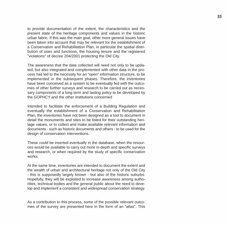
As a contribution to this process, some of the possible relevant outco-mes of the survey are presented here in the form of an "atlas". This
shows the possible use of the inventories as a tool to increase the kno-wledge and understanding of the historic fabric, while still focusing onsome of the issues to be addressed in the next phases.
36
Fig. 7 - The survey areas in the Old City ofSana'a.

The Inventory of the Old City covers the protected perimeter as defi-ned by the decree no. 17/1994 and by the decree issued by the PrimeMinister (no. 204/2001), where there is an urgent need to establish adetailed and effective Building Regulation, fixing clear rules for buildingactivities which may affect the heritage values of the historic fabric andits different components. The survey area of the inventory thus inclu-des:
- the urban fabric encompassed within the ancient City walls, whichcorresponds to the World Heritage site. As mentioned above, thisincludes several developments between the 1930s and the 1990s,which respect to a certain extent the traditional patterns and construc-tion methods;
- the new fabric of the development or renewal interventions thatoccurred since the 1970s, surrounding and sometimes replacing thesame city walls along Ali Abdul Moghni Street to the west, Az-Zubayriand As-Salam street to the south, Al Laqiya street to the east, and BabAch-Sha'ub street to the north. Here the building typologies and theconstruction methods mostly correspond to "modern" patterns even ifthey attempt to imitate the traditional architectural styles.
This perimeter was covered by the survey carried out by GOPHCY inJuly 2002 - February 2003 in order to identify the "violations". It shouldbe noted that the two fabrics often merge, particularly along Ali AbdulMoghni Street to the west and near the gates. Therefore a clear dis-tinction between the preserved historic fabric and the "neo-traditional"is impossible. As a result, the inventory was carried out using the samecriteria for both.
The information sought for the establishment of the inventory reflectsstrong concern for the identification of the distinctive elements, whichdetermine the heritage values of the historic and traditional architectu-re and urban fabric of the Old City and need to be preserved in their
37
The Inventory of the Old City

authenticity and integrity. To this end, reference has been made to theseveral important studies available on the traditional Sana'ni houseand architectural know-how15.
The field survey
The inventory has been implemented through an extensive field sur-vey, by mean of a visual analysis carried out from the street and somehigh observation points (i.e. the roofs of the highest buildings in theblocks), normally without entering the buildings or interviewing the resi-dents. It consisted of two main types of data:
- the record of the relevant physical and functional features;- the evaluation of the state of conservation, the architectural qualityand other relevant aspects, which imply a judgement based on pre-established criteria.
The survey sheets to collect the required information have been struc-tured to enable the direct entry of the data into the GIS system. Thisincludes codified fields which refer to:
- the buildings and related open spaces in the residential quarters;- the buildings and the related open spaces in the souk area;- the bustans, megshamat and other relevant open spaces.
Besides the necessary data for the identification of the building or openspace, the survey sheets were structured in the following sections,each one documenting a set of characteristics and issues highlightedby the available studies, and to be addressed by the BuildingRegulation and the Conservation and Rehabilitation Plan.
As for the buildings in the residential quarter, the data collected refer-red to each single building unit, even in the case of larger houses orresidential clusters, which may be formed by several interconnectedconstructions:
- general information on the building: ownership, number of residentfamilies;- typological and architectural characteristics: number of floors, size,type of roof and presence of contemporary installations and/or traditio-
38
nal structures, types of transformations (including additions) made inthe last 15 years and materials used;- state of occupancy and uses: functional typology, functions at theground and upper floors, presence of dangerous or harmful activities;- evaluation of the physical state of conservation, the architectural qua-lity and the required interventions;- presence and types of "violations" according to the decree 204/2001and the survey, 2002.
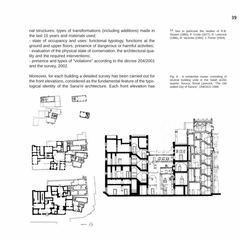
Moreover, for each building a detailed survey has been carried out forthe front elevations, considered as the fundamental feature of the typo-logical identity of the Sana'ni architecture. Each front elevation has
39
15 See in particular the studies of R.B.Serjant (1980), P. Costa (1977), R. Lewcock(1986), R. Varanda (1994), J. Feiner (2004).
Fig. 8 - A residential cluster consisting ofseveral building units in the Salah al-Dinquarter. Source, Ronal Lewcock, "The Oldwalled City of Sana'a", UNESCO 1986.

been identified with reference to its surrounding context and its diffe-rent components have been recorded according to the following struc-ture:
- composition layout: presence of different architectural layers andperiods of construction;- ground floor: type of structure, type of entrances and other openingsand related materials;- upper storeys: type of structure, type of openings and related mate-rials, presence of added components and decorative elements;- presence of "violations".
Finally, the open spaces and non built-up areas related to each buil-ding have been identified and recorded in order to provide the follo-wing information:
- typology, uses and existing structures;- entrances and fences, including materials;- general conditions.
Similarly, the survey sheet for the bustans, mekshamat and other rele-vant open spaces includes the following information:
- ownership, typology and use of the space: in particular, this is intend-ed to identify the type of space (bustan, mekshamat and others), aswell as the type of use and prevailing vegetation;- fencing and hard landscaping: information on the fencing walls, pathsand paved areas when existing, including materials, recent transfor-mations and specific interventions required;- irrigation: information on the type of water supply and irrigationsystem;- evaluation of the overall state of conservation, the architectural qua-lity and the required interventions.
As for the buildings in the souk area, the same structure was used, butreference has been made to different architectural and functional ele-ments. Moreover, due to the specific one-storey typology of the Souks,no detailed investigation was needed on front elevations, and no openspaces have to be recorded.
40
41
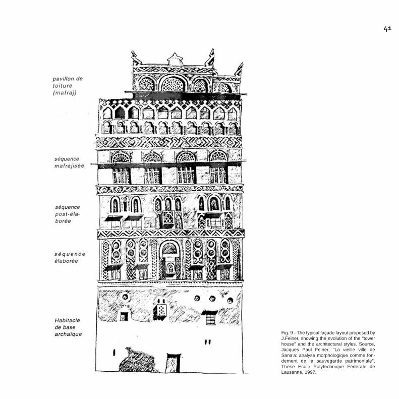
Fig. 9 - The typical façade layout proposed byJ.Feiner, showing the evolution of the "towerhouse" and the architectural styles. Source,Jacques Paul Feiner, "La vieille ville deSana'a: analyse morphologique comme fon-dement de la sauvegarde patrimoniale",Thèse Ecole Polytechnique Fédérale deLausanne, 1997.
The criteria of evaluation
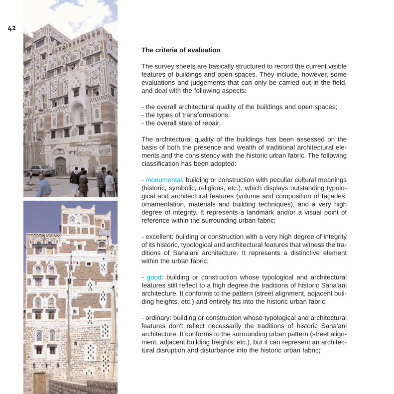
The survey sheets are basically structured to record the current visiblefeatures of buildings and open spaces. They include, however, someevaluations and judgements that can only be carried out in the field,and deal with the following aspects:
- the overall architectural quality of the buildings and open spaces;- the types of transformations;- the overall state of repair.
The architectural quality of the buildings has been assessed on thebasis of both the presence and wealth of traditional architectural ele-ments and the consistency with the historic urban fabric. The followingclassification has been adopted:
- monumental: building or construction with peculiar cultural meanings(historic, symbolic, religious, etc.), which displays outstanding typolo-gical and architectural features (volume and composition of façades,ornamentation, materials and building techniques), and a very highdegree of integrity. It represents a landmark and/or a visual point ofreference within the surrounding urban fabric;
- excellent: building or construction with a very high degree of integrityof its historic, typological and architectural features that witness the tra-ditions of Sana'ani architecture. It represents a distinctive elementwithin the urban fabric;
- good: building or construction whose typological and architecturalfeatures still reflect to a high degree the traditions of historic Sana'aniarchitecture. It conforms to the pattern (street alignment, adjacent buil-ding heights, etc.) and entirely fits into the historic urban fabric;
- ordinary: building or construction whose typological and architecturalfeatures don't reflect necessarily the traditions of historic Sana'aniarchitecture. It conforms to the surrounding urban pattern (street align-ment, adjacent building heights, etc.), but it can represent an architec-tural disruption and disturbance into the historic urban fabric;
42

- inconsistent: building or construction whose typological and architec-tural features contrast with the traditions of historic Sana'ani architec-ture. It doesn't conform to the surrounding urban pattern (street align-ment, adjacent building heights, etc.), and/or represents a rupture with,and a heavy visual intrusion into the historic urban fabric.
43
As for the recent transformations made to the buildings and open spa-ces, reference has been made to the date (1989) of the most accura-te map of the city available when the survey was carried out, in orderto detect the new buildings, the demolitions and other changes whichhad taken place in relation to the fabric. Based on specific training onthe job, the presence of recent additions, installations and other typesof construction has been recorded and a general evaluation of thetypes of interventions has been given according to the following cate-gories:
- restoration: when the typological and architectural features of thewhole building, or at least an important part of it, were totally preser-ved and restored to a previous historic condition;
- rehabilitation: when the building has been made available to previousor new uses, consistent with its historic, typological and architecturalcharacteristics, adapting the structures to new functional needs (inte-rior distribution, equipment, etc.), without changes to volume, height,articulation of spaces, façade composition and ornamentation layout;
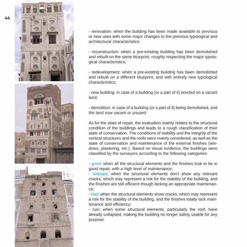
- renovation: when the building has been made available to previousor new uses with some major changes to the previous typological andarchitectural characteristics;
- reconstruction: when a pre-existing building has been demolishedand rebuilt on the same blueprint, roughly respecting the major typolo-gical characteristics;
- redevelopment: when a pre-existing building has been demolishedand rebuilt on a different blueprint, and with entirely new typologicalcharacteristics;
- new building: in case of a building (or a part of it) erected on a vacantland;
- demolition: in case of a building (or a part of it) being demolished, andthe land now vacant or unused.
As for the state of repair, the evaluation mainly relates to the structuralcondition of the buildings and leads to a rough classification of theirstate of conservation. The conditions of stability and the integrity of thevertical structures and the roofs were mainly considered, as well as thestate of conservation and maintenance of the external finishes (win-dows, plastering, etc.). Based on visual evidence, the buildings wereclassified by the surveyors according to the following categories:
- good: when all the structural elements and the finishes look to be ingood repair, with a high level of maintenance;- ordinary: when the structural elements don't show any relevantcracks, which may represent a risk for the stability of the building, andthe finishes are still efficient though lacking an appropriate maintenan-ce;- bad: when the structural elements show cracks, which may representa risk for the stability of the building, and the finishes totally lack main-tenance and efficiency;- ruin: when some structural elements, particularly the roof, havealready collapsed, making the building no longer safety usable for anypurpose.
44

The survey "handbook"
The surveyors and all the work team at GOPHCY needed a commonoutlook and shared criteria in the recognition and assessment of theheritage features as an essential condition in performing the inventorycorrectly, and also to increase cultural awareness and technical skillsthrough a dedicated training program. This was initially developedthrough seminars and lectures on the different issues concerning thesurvey implementation, the use of the geographic databases and themanagement of informatics tools. It was later performed in all the sub-sequent phases of the field survey, data entry and GIS constructionand exploitation.
In this framework, a "handbook" has been formulated by the expertsfor the surveyors, in order to provide the operational guidelines to per-form the different phases of the survey and GIS construction, i.e. theupdating of the existing cartography, the identification of the "objects"to be surveyed (buildings, elevations, open spaces, etc.), collecting therequired information, the photographic survey, the data entry.
In particular, the "handbook" was intended to be a tool to be used on-site by the surveyors to recognise and assess all the features andarchitectural elements found in the buildings and open spaces to beinventoried - be they "traditional" or "contemporary", with heritagevalues or inconsistent. It provides a sort of basic architectural "voca-bulary", based on the studies cited above, and reinforced by the com-mon know-how of the professional and experts at GOPHCY, the uni-versity and other national and international institutions, which are ormay be concerned with heritage conservation and planning in theCapital city.
Some examples of the "vocabulary", which refer to different "fields" ofthe survey sheet for the buildings and the front elevations, are pre-sented in the following pages.
It is hoped that this "handbook" would be integrated and completed tobecome a tool not only to increase heritage understanding amongststudents and professionals, but also to raise awareness among thewider public.
45

46
Building - Front elevation
General composition
Identify the composition rules which thefront elevation consists of. This frontelevation consists of 1 architecturallayout.
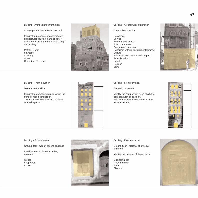
Building - Architectural information
Main function of upper storeys
ResidenceServiceCultureAdministrationHealthReligionStoreNeiborough's shopTown commerce
Building - Front elevation
Ground floor - Principal and secondaryentrance
Point out if the entrance of the buildingfaces directly the street.
From the courtyardFrom the street
Building - Front elevation
Ground floor - Principal and secondaryentrance
Point out if the entrance of the buildingfaces the courtyard.
From the courtyardFrom the street
Building - Architectural information
Vertical addition
Identify the presence of vertical addic-tions; specify the date of their construc-tion and the number of floors that havebeen added; point out if the addictionsare consistent with the original buil-dings.
Date:Number of floors:Consistent: Yes - No
Building - Architectural information
Traditional structures on the roof
Identify the presence of traditionalarchitectural structures consistent withthe building.
Mafraj - DiwanStaircaseChimney
47
Building - Architectural information
Ground floor function
ResidenceServiceNeiborough's shopeTown commerceDangerous commerceHandicraft without environmental impactCultureHandicraft with enviromental impactAdministrationHealthReligionStore
Building - Front elevation
General composition
Identify the composition rules which thefront elevation consists of.This front elevation consists of 2 archi-tectural layouts.
Building - Front elevation
General composition
Identify the composition rules which thefront elevation consists of.This front elevation consists of 3 archi-tectural layouts.
Building - Front elevation
Ground floor - Material of principalentrance
Identify the material of the entrance.
Original timberModern timberMetalPlywood
Building - Front elevation
Ground floor - Use of second entrance
Identify the use of the secondaryentrance.
ClosedShop doorIn use
Building - Architectural information
Contemporary structures on the roof
Identify the presence of contemporaryarchitectural structures and specify ifthey are consistent or not with the origi-nal building.
Mafraj - DiwanStaircaseChimneyOtherConsistent: Yes - No

48
Building - Front elevation
Ground floor - Material of ground floor'sstructure
Identify the building material of thebasic structureof the ground floor.
Wajh: external stone facingsHabash: black lava stoneWaqis: hewn stoneZabur: sun dried coarse clay'Ajur: baked bricks
Building - Front elevation
Ground floor - Material of ground floorstructure
Wajh: external stone facings
Building - Front elevation
Ground floor - Material of ground floorstructure
Habash: black lava stone
Building - Front elevation
Ground floor - Material of ground floorstructure
Zabur: sun dried coarse clay
Building - Front elevation
Ground floor - Material of contemporarywindows frame
Metal - AluminiumTimberMix
Building - Front elevation
Ground floor - Material of contemporaryshop door
Metal - AluminiumTimberMix
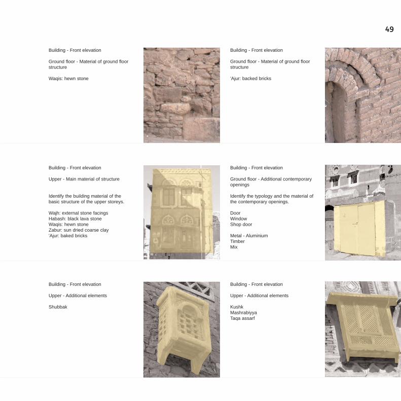
49
Building - Front elevation
Ground floor - Material of ground floorstructure
Waqis: hewn stone
Building - Front elevation
Ground floor - Material of ground floorstructure
'Ajur: backed bricks
Building - Front elevation
Upper - Main material of structure
Identify the building material of thebasic structure of the upper storeys.
Wajh: external stone facingsHabash: black lava stoneWaqis: hewn stoneZabur: sun dried coarse clay'Ajur: baked bricks
Building - Front elevation
Ground floor - Additional contemporaryopenings
Identify the typology and the material ofthe contemporary openings.
DoorWindowShop door
Metal - AluminiumTimberMix
Building - Front elevation
Upper - Additional elements
KushkMashrabiyyaTaqa assarf
Building - Front elevation
Upper - Additional elements
Shubbak
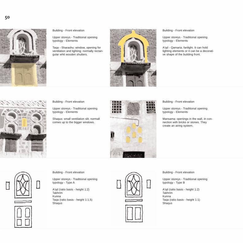
50
Building - Front elevation
Upper storeys - Traditional openingtypology - Elements
A'qd - Qamaria: fanlight. It can holdlighting elements or it can be a decorati-ve shape of the building front.
Building - Front elevation
Upper storeys - Traditional openingtypology - Elements
Taqa - Sharashu: window, opening forventilation and lighting; normally rectan-gular whit wooden shutters.
Building - Front elevation
Upper storeys - Traditional openingtypology - Elements
Shaqus: small ventilation slit; normallcomes up to the bigger windows.
Building - Front elevation
Upper storeys - Traditional openingtypology - Elements
Mansama: openings in the wall, in con-nection with bricks or stones. Theycreate an airing system.
Building - Front elevation
Upper storeys - Traditional openingtypology - Type A
A'qd (ratio basis - height 1:2)TakhrimKunnaTaqa (ratio basis - height 1:1,5)Shaqus
Building - Front elevation
Upper storeys - Traditional openingtypology - Type B
A'qd (ratio basis - height 1:2)TakhrimKunnaTaqa (ratio basis - height 1:1)Shaqus
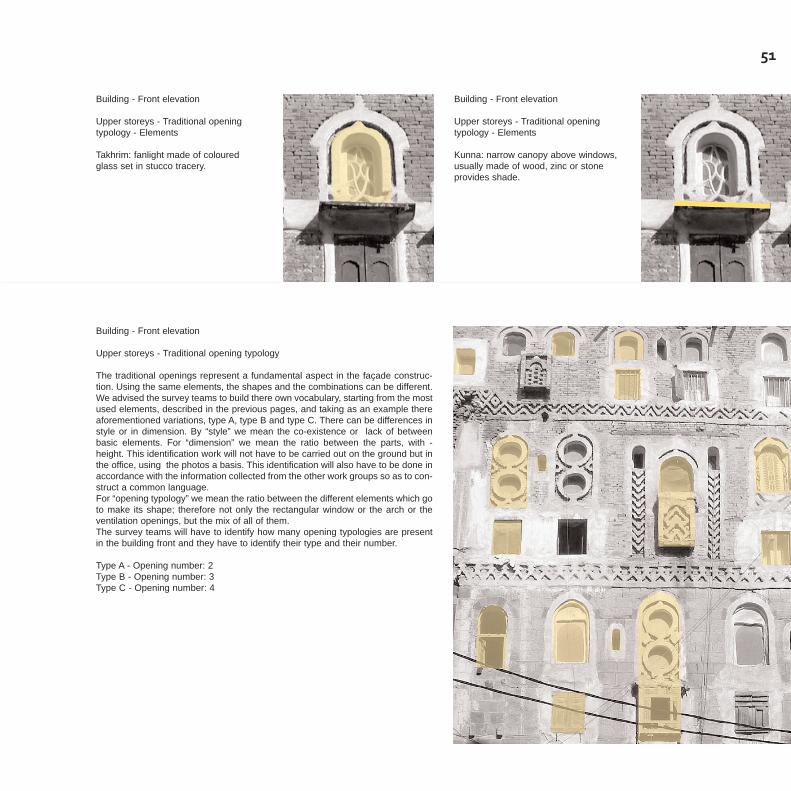
51
Building - Front elevation
Upper storeys - Traditional openingtypology - Elements
Takhrim: fanlight made of colouredglass set in stucco tracery.
Building - Front elevation
Upper storeys - Traditional openingtypology - Elements
Kunna: narrow canopy above windows,usually made of wood, zinc or stoneprovides shade.
Building - Front elevation
Upper storeys - Traditional opening typology
The traditional openings represent a fundamental aspect in the façade construc-tion. Using the same elements, the shapes and the combinations can be different.We advised the survey teams to build there own vocabulary, starting from the mostused elements, described in the previous pages, and taking as an example thereaforementioned variations, type A, type B and type C. There can be differences instyle or in dimension. By “style” we mean the co-existence or lack of betweenbasic elements. For “dimension” we mean the ratio between the parts, with -height. This identification work will not have to be carried out on the ground but inthe office, using the photos a basis. This identification will also have to be done inaccordance with the information collected from the other work groups so as to con-struct a common language.For “opening typology” we mean the ratio between the different elements which goto make its shape; therefore not only the rectangular window or the arch or theventilation openings, but the mix of all of them.The survey teams will have to identify how many opening typologies are presentin the building front and they have to identify their type and their number.
Type A - Opening number: 2Type B - Opening number: 3Type C - Opening number: 4
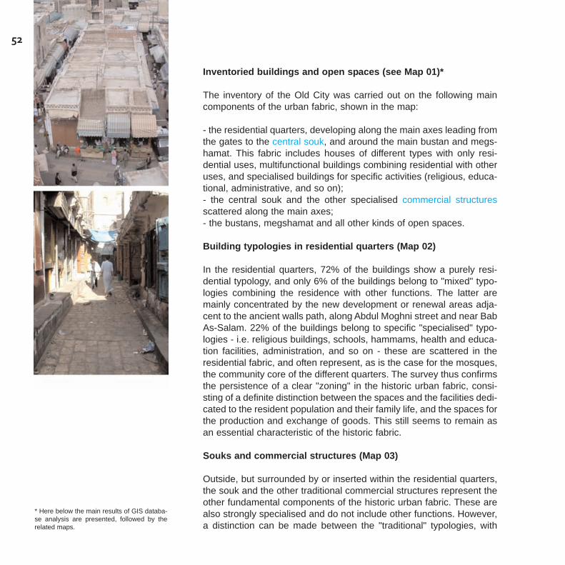
52
Inventoried buildings and open spaces (see Map 01)*
The inventory of the Old City was carried out on the following maincomponents of the urban fabric, shown in the map:
- the residential quarters, developing along the main axes leading fromthe gates to the central souk, and around the main bustan and megs-hamat. This fabric includes houses of different types with only resi-dential uses, multifunctional buildings combining residential with otheruses, and specialised buildings for specific activities (religious, educa-tional, administrative, and so on);- the central souk and the other specialised commercial structuresscattered along the main axes;- the bustans, megshamat and all other kinds of open spaces.
Building typologies in residential quarters (Map 02)
In the residential quarters, 72% of the buildings show a purely resi-dential typology, and only 6% of the buildings belong to "mixed" typo-logies combining the residence with other functions. The latter aremainly concentrated by the new development or renewal areas adja-cent to the ancient walls path, along Abdul Moghni street and near BabAs-Salam. 22% of the buildings belong to specific "specialised" typo-logies - i.e. religious buildings, schools, hammams, health and educa-tion facilities, administration, and so on - these are scattered in theresidential fabric, and often represent, as is the case for the mosques,the community core of the different quarters. The survey thus confirmsthe persistence of a clear "zoning" in the historic urban fabric, consi-sting of a definite distinction between the spaces and the facilities dedi-cated to the resident population and their family life, and the spaces forthe production and exchange of goods. This still seems to remain asan essential characteristic of the historic fabric.
Souks and commercial structures (Map 03)
Outside, but surrounded by or inserted within the residential quarters,the souk and the other traditional commercial structures represent theother fundamental components of the historic urban fabric. These arealso strongly specialised and do not include other functions. However,a distinction can be made between the "traditional" typologies, with
* Here below the main results of GIS databa-se analysis are presented, followed by therelated maps.
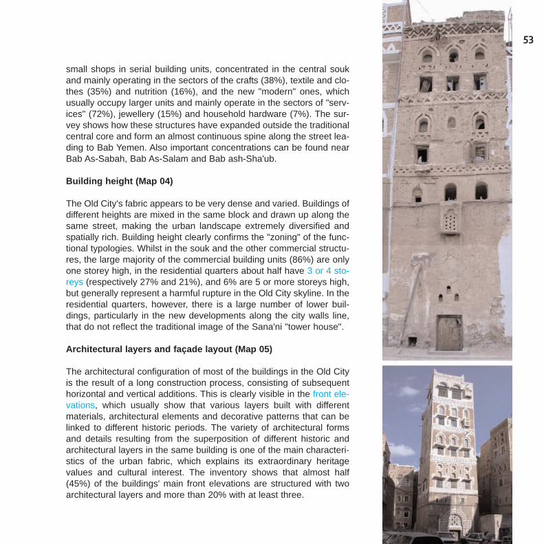
53
small shops in serial building units, concentrated in the central soukand mainly operating in the sectors of the crafts (38%), textile and clo-thes (35%) and nutrition (16%), and the new "modern" ones, whichusually occupy larger units and mainly operate in the sectors of "serv-ices" (72%), jewellery (15%) and household hardware (7%). The sur-vey shows how these structures have expanded outside the traditionalcentral core and form an almost continuous spine along the street lea-ding to Bab Yemen. Also important concentrations can be found nearBab As-Sabah, Bab As-Salam and Bab ash-Sha'ub.
Building height (Map 04)
The Old City's fabric appears to be very dense and varied. Buildings ofdifferent heights are mixed in the same block and drawn up along thesame street, making the urban landscape extremely diversified andspatially rich. Building height clearly confirms the "zoning" of the func-tional typologies. Whilst in the souk and the other commercial structu-res, the large majority of the commercial building units (86%) are onlyone storey high, in the residential quarters about half have 3 or 4 sto-reys (respectively 27% and 21%), and 6% are 5 or more storeys high,but generally represent a harmful rupture in the Old City skyline. In theresidential quarters, however, there is a large number of lower buil-dings, particularly in the new developments along the city walls line,that do not reflect the traditional image of the Sana'ni "tower house".
Architectural layers and façade layout (Map 05)
The architectural configuration of most of the buildings in the Old Cityis the result of a long construction process, consisting of subsequenthorizontal and vertical additions. This is clearly visible in the front ele-vations, which usually show that various layers built with differentmaterials, architectural elements and decorative patterns that can belinked to different historic periods. The variety of architectural formsand details resulting from the superposition of different historic andarchitectural layers in the same building is one of the main characteri-stics of the urban fabric, which explains its extraordinary heritagevalues and cultural interest. The inventory shows that almost half(45%) of the buildings' main front elevations are structured with twoarchitectural layers and more than 20% with at least three.
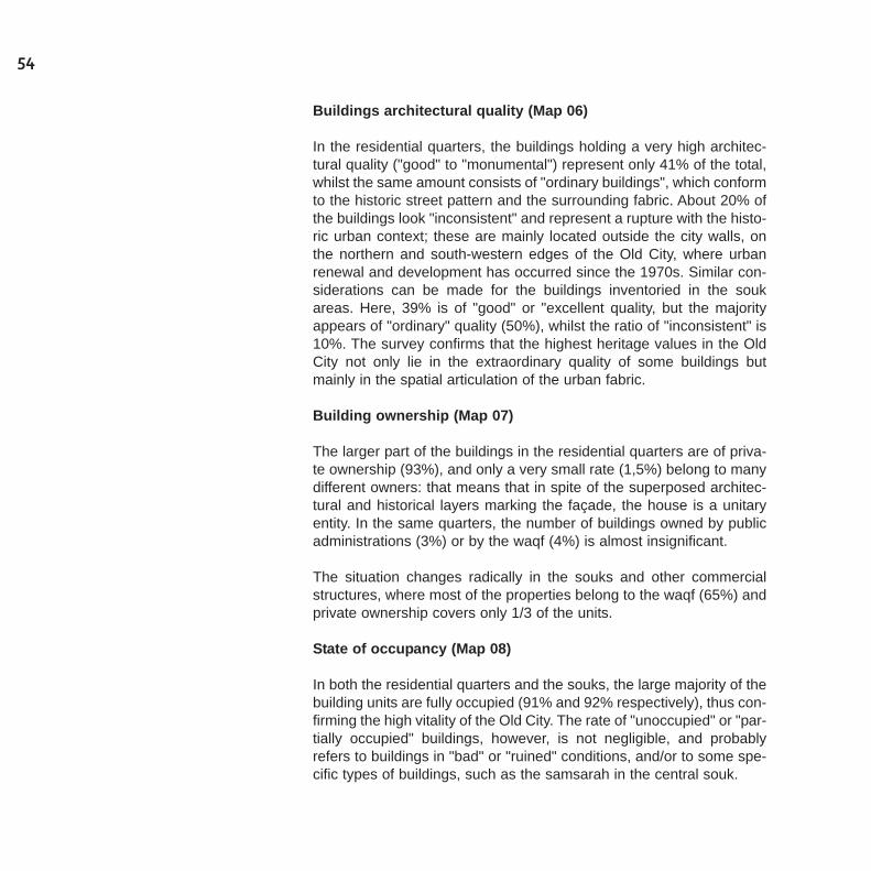
54
Buildings architectural quality (Map 06)
In the residential quarters, the buildings holding a very high architec-tural quality ("good" to "monumental") represent only 41% of the total,whilst the same amount consists of "ordinary buildings", which conformto the historic street pattern and the surrounding fabric. About 20% ofthe buildings look "inconsistent" and represent a rupture with the histo-ric urban context; these are mainly located outside the city walls, onthe northern and south-western edges of the Old City, where urbanrenewal and development has occurred since the 1970s. Similar con-siderations can be made for the buildings inventoried in the soukareas. Here, 39% is of "good" or "excellent quality, but the majorityappears of "ordinary" quality (50%), whilst the ratio of "inconsistent" is10%. The survey confirms that the highest heritage values in the OldCity not only lie in the extraordinary quality of some buildings butmainly in the spatial articulation of the urban fabric.
Building ownership (Map 07)
The larger part of the buildings in the residential quarters are of priva-te ownership (93%), and only a very small rate (1,5%) belong to manydifferent owners: that means that in spite of the superposed architec-tural and historical layers marking the façade, the house is a unitaryentity. In the same quarters, the number of buildings owned by publicadministrations (3%) or by the waqf (4%) is almost insignificant.
The situation changes radically in the souks and other commercialstructures, where most of the properties belong to the waqf (65%) andprivate ownership covers only 1/3 of the units.
State of occupancy (Map 08)
In both the residential quarters and the souks, the large majority of thebuilding units are fully occupied (91% and 92% respectively), thus con-firming the high vitality of the Old City. The rate of "unoccupied" or "par-tially occupied" buildings, however, is not negligible, and probablyrefers to buildings in "bad" or "ruined" conditions, and/or to some spe-cific types of buildings, such as the samsarah in the central souk.
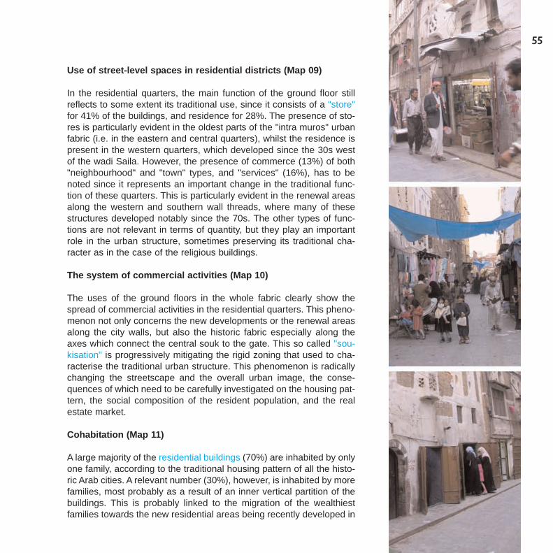
55
Use of street-level spaces in residential districts (Map 09)
In the residential quarters, the main function of the ground floor stillreflects to some extent its traditional use, since it consists of a "store"for 41% of the buildings, and residence for 28%. The presence of sto-res is particularly evident in the oldest parts of the "intra muros" urbanfabric (i.e. in the eastern and central quarters), whilst the residence ispresent in the western quarters, which developed since the 30s westof the wadi Saila. However, the presence of commerce (13%) of both"neighbourhood" and "town" types, and "services" (16%), has to benoted since it represents an important change in the traditional func-tion of these quarters. This is particularly evident in the renewal areasalong the western and southern wall threads, where many of thesestructures developed notably since the 70s. The other types of func-tions are not relevant in terms of quantity, but they play an importantrole in the urban structure, sometimes preserving its traditional cha-racter as in the case of the religious buildings.
The system of commercial activities (Map 10)
The uses of the ground floors in the whole fabric clearly show thespread of commercial activities in the residential quarters. This pheno-menon not only concerns the new developments or the renewal areasalong the city walls, but also the historic fabric especially along theaxes which connect the central souk to the gate. This so called "sou-kisation" is progressively mitigating the rigid zoning that used to cha-racterise the traditional urban structure. This phenomenon is radicallychanging the streetscape and the overall urban image, the conse-quences of which need to be carefully investigated on the housing pat-tern, the social composition of the resident population, and the realestate market.
Cohabitation (Map 11)
A large majority of the residential buildings (70%) are inhabited by onlyone family, according to the traditional housing pattern of all the histo-ric Arab cities. A relevant number (30%), however, is inhabited by morefamilies, most probably as a result of an inner vertical partition of thebuildings. This is probably linked to the migration of the wealthiestfamilies towards the new residential areas being recently developed in
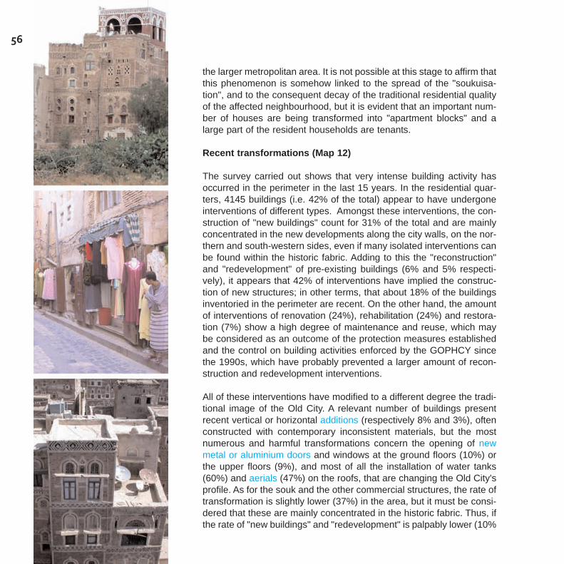
56
the larger metropolitan area. It is not possible at this stage to affirm thatthis phenomenon is somehow linked to the spread of the "soukuisa-tion", and to the consequent decay of the traditional residential qualityof the affected neighbourhood, but it is evident that an important num-ber of houses are being transformed into "apartment blocks" and alarge part of the resident households are tenants.
Recent transformations (Map 12)
The survey carried out shows that very intense building activity hasoccurred in the perimeter in the last 15 years. In the residential quar-ters, 4145 buildings (i.e. 42% of the total) appear to have undergoneinterventions of different types. Amongst these interventions, the con-struction of "new buildings" count for 31% of the total and are mainlyconcentrated in the new developments along the city walls, on the nor-thern and south-western sides, even if many isolated interventions canbe found within the historic fabric. Adding to this the "reconstruction"and "redevelopment" of pre-existing buildings (6% and 5% respecti-vely), it appears that 42% of interventions have implied the construc-tion of new structures; in other terms, that about 18% of the buildingsinventoried in the perimeter are recent. On the other hand, the amountof interventions of renovation (24%), rehabilitation (24%) and restora-tion (7%) show a high degree of maintenance and reuse, which maybe considered as an outcome of the protection measures establishedand the control on building activities enforced by the GOPHCY sincethe 1990s, which have probably prevented a larger amount of recon-struction and redevelopment interventions.
All of these interventions have modified to a different degree the tradi-tional image of the Old City. A relevant number of buildings presentrecent vertical or horizontal additions (respectively 8% and 3%), oftenconstructed with contemporary inconsistent materials, but the mostnumerous and harmful transformations concern the opening of newmetal or aluminium doors and windows at the ground floors (10%) orthe upper floors (9%), and most of all the installation of water tanks(60%) and aerials (47%) on the roofs, that are changing the Old City'sprofile. As for the souk and the other commercial structures, the rate oftransformation is slightly lower (37%) in the area, but it must be consi-dered that these are mainly concentrated in the historic fabric. Thus, ifthe rate of "new buildings" and "redevelopment" is palpably lower (10%
57
and 6% respectively), large and sometimes intrusive recent interven-tions can be found especially in the surroundings of the central souk,whilst the large majority of the interventions consist in "renovation"(56%), rehabilitation (20%) and restoration (7%).
If many of these interventions reflect the need to adapt the traditionalbuildings to the needs of modern life, and are unavoidable to a largeextent, the risk must be stressed of a serious loss of the heritagevalues in the historic fabric, since the architectural criteria, the buildingtechniques and the materials used are often in contrast with the tradi-tional know-how and architectural characters. However, these trans-formations are also to be considered as a sign of the attractivenessand vitality of the Old City, and of the capacity of its urban pattern toaccommodate new uses and functions.
Repair of the Buildings (Map 13)
The state of conservation has been evaluated on the basis of the"general conditions" of the buildings as they appear from the front ele-vations on the street and the open spaces, taking into considerationthe type and the stability of the structure, the presence and the consi-stency of the traditional architectural and decorative elements, the kindof materials. Also the presence of elements, which may disfigure thetraditional shape and the heritage values of the buildings have beenconsidered, such as additions and new openings with inconsistentmaterials.
Thus the classification combines different types of data, in order todefine the degree of integrity and the heritage interest of the building.It clearly reflects the intense building activity and the high degree oftransformation which has occurred in recent years. In the residentialquarters, almost half of the buildings appear to be in "good" condition(49%), and 34% "ordinary", due to insufficient maintenance or inconsi-stent renovation and reconstruction. It has to be noted, however, that17 % are in "bad" or "ruined" condition and require urgent interven-tions. As for the souk and commercial structures, most of them (57%)show "ordinary" conditions, mainly due to the presence of inconsistentmaterials and openings, whilst 30% can be considered in "good con-dition". Also the rate of "bad" and "ruined" (13%), though lower than inthe residential quarters, is far from being negligible. This data, if com-
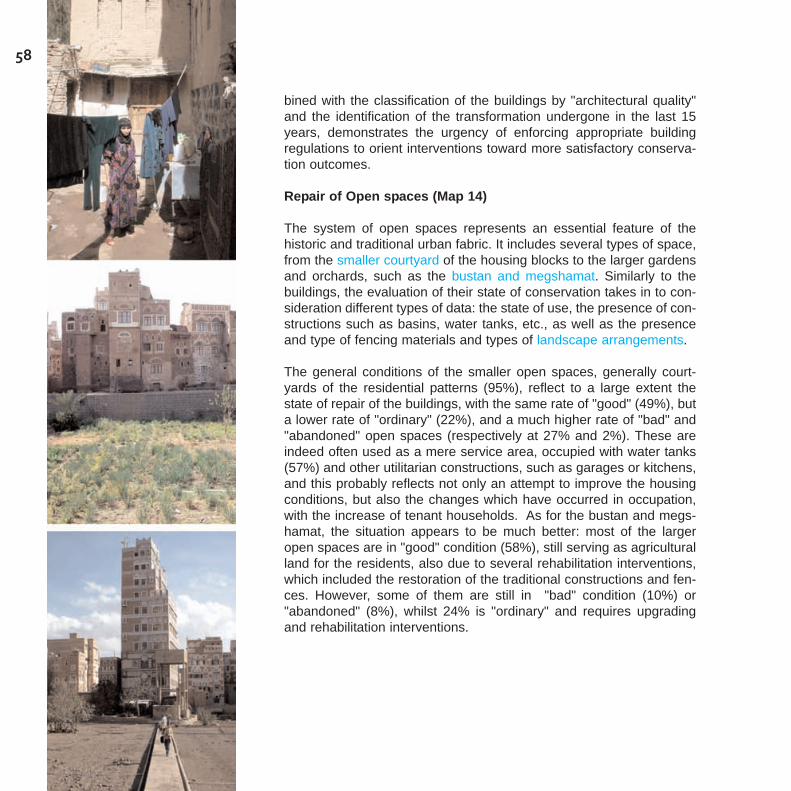
58
bined with the classification of the buildings by "architectural quality"and the identification of the transformation undergone in the last 15years, demonstrates the urgency of enforcing appropriate buildingregulations to orient interventions toward more satisfactory conserva-tion outcomes.
Repair of Open spaces (Map 14)
The system of open spaces represents an essential feature of thehistoric and traditional urban fabric. It includes several types of space,from the smaller courtyard of the housing blocks to the larger gardensand orchards, such as the bustan and megshamat. Similarly to thebuildings, the evaluation of their state of conservation takes in to con-sideration different types of data: the state of use, the presence of con-structions such as basins, water tanks, etc., as well as the presenceand type of fencing materials and types of landscape arrangements.
The general conditions of the smaller open spaces, generally court-yards of the residential patterns (95%), reflect to a large extent thestate of repair of the buildings, with the same rate of "good" (49%), buta lower rate of "ordinary" (22%), and a much higher rate of "bad" and"abandoned" open spaces (respectively at 27% and 2%). These areindeed often used as a mere service area, occupied with water tanks(57%) and other utilitarian constructions, such as garages or kitchens,and this probably reflects not only an attempt to improve the housingconditions, but also the changes which have occurred in occupation,with the increase of tenant households. As for the bustan and megs-hamat, the situation appears to be much better: most of the largeropen spaces are in "good" condition (58%), still serving as agriculturalland for the residents, also due to several rehabilitation interventions,which included the restoration of the traditional constructions and fen-ces. However, some of them are still in "bad" condition (10%) or"abandoned" (8%), whilst 24% is "ordinary" and requires upgradingand rehabilitation interventions.

59
Map 01 - The inventoriedbuildings and open spaces
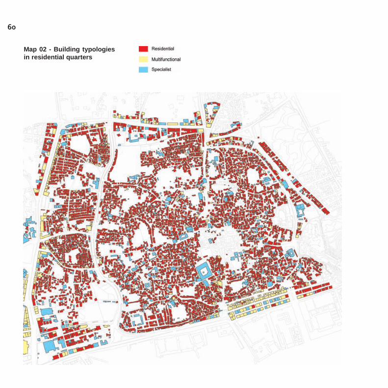
60
Map 02 - Building typologiesin residential quarters

61
Map 03 - Suqs and commer-cial structures
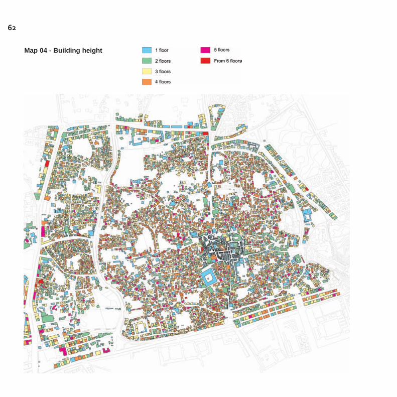
62
Map 04 - Building height
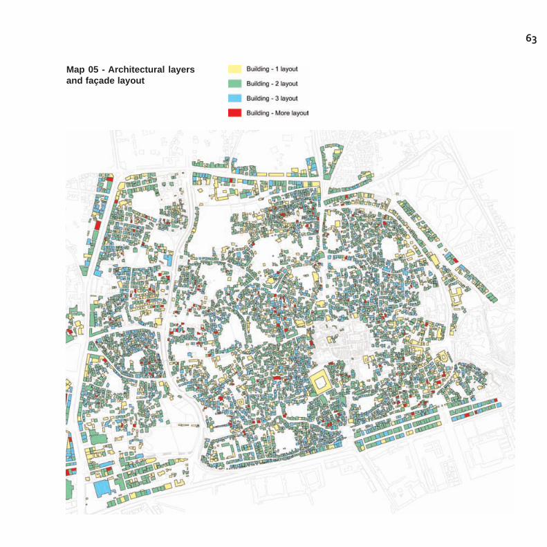
63
Map 05 - Architectural layersand façade layout

64
Map 06 - Buildings architec-tural quality
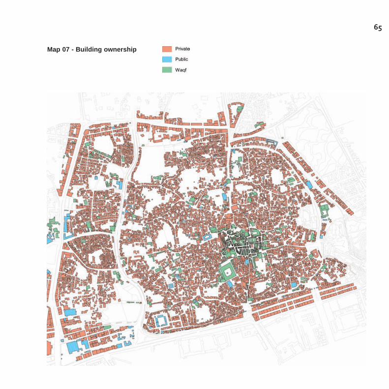
65
Map 07 - Building ownership
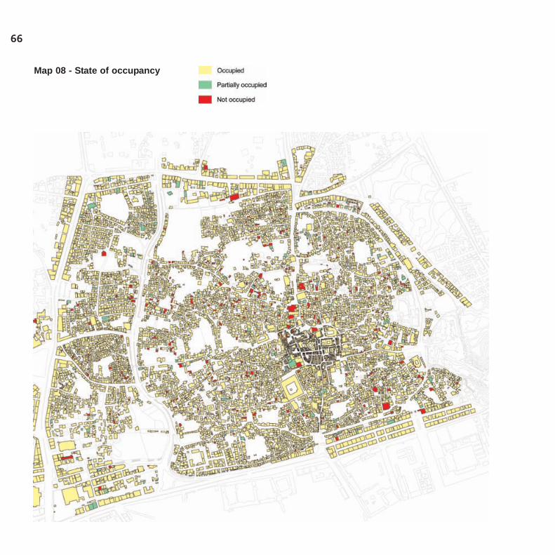
66
Map 08 - State of occupancy
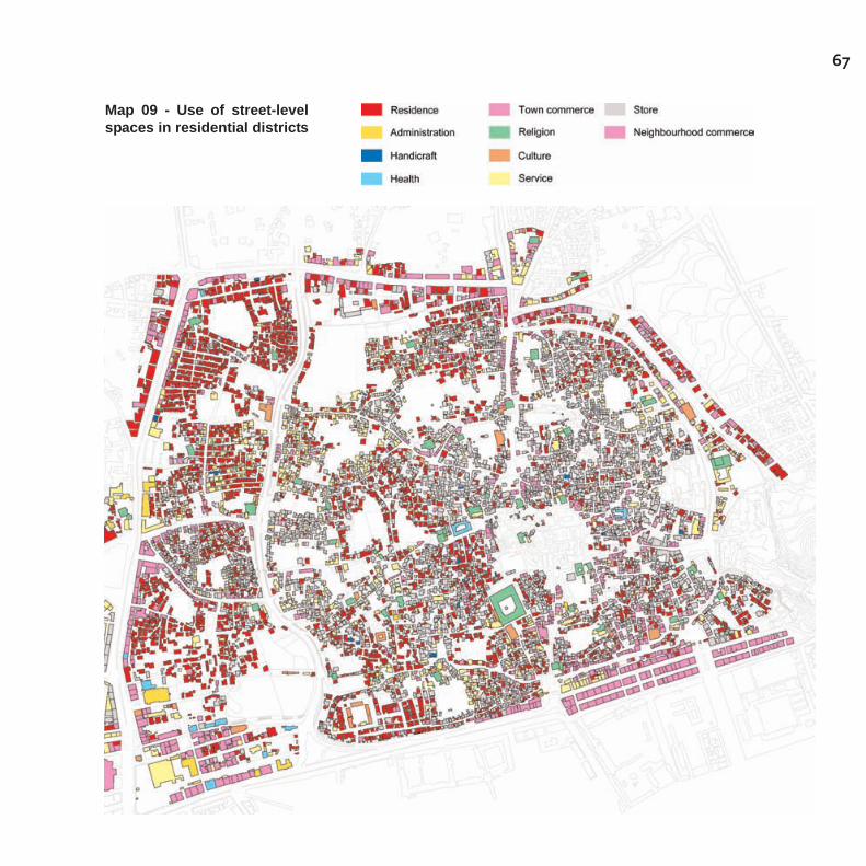
67
Map 09 - Use of street-levelspaces in residential districts

68
Map 10 - The system of com-mercial activities
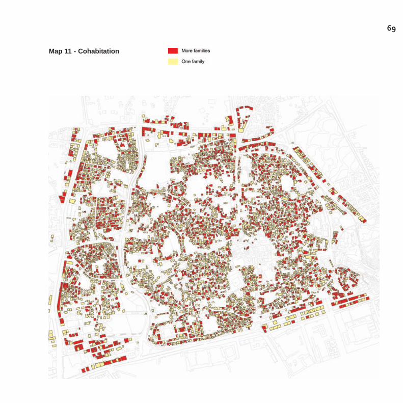
69
Map 11 - Cohabitation
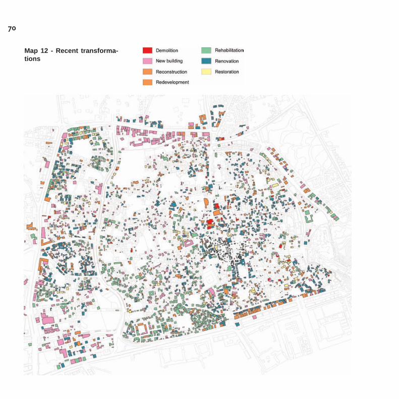
70
Map 12 - Recent transforma-tions

71
Map 13 - Repair of theBuildings
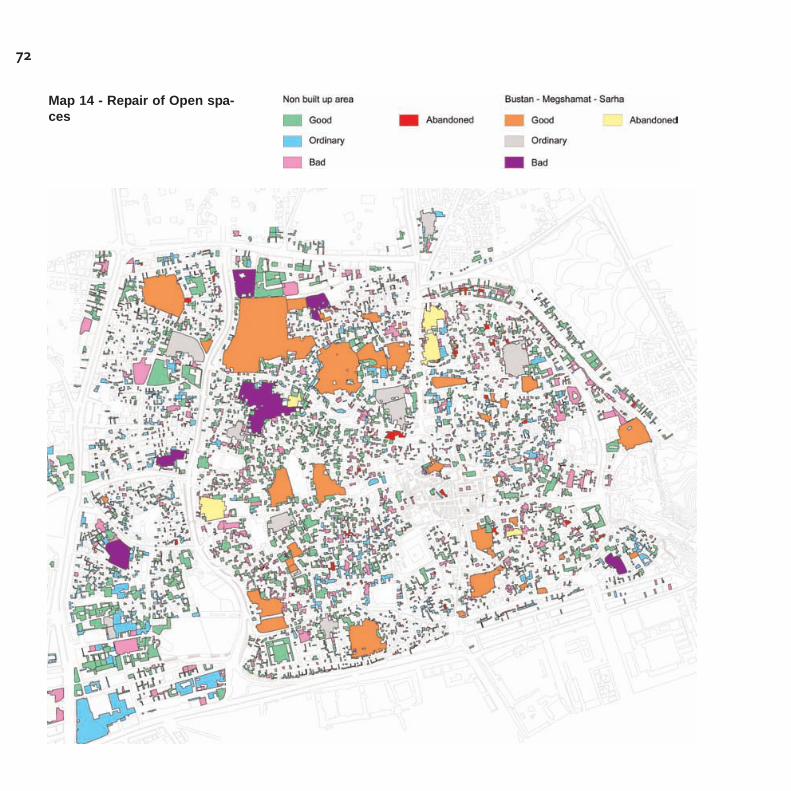
72
Map 14 - Repair of Open spa-ces
73
As for the suburbs of Bir Al Azab and Rawdah, the inventory was deve-loped as an extension of the one already undertaken for the Old Cityof Sana'a, after the decision of the Yemeni Government to issue adecree for the protection of Bir el Azab, El Gabel village, Hadda villa-ge, Sana village, Rawdah, Attan village and Beit Bows village as heri-tage of national interest16. The limited resources available led to theclassification of the two main historic suburbs of Bir Al Azab andRawdah as priority areas as they are seriously threatened by majortransformations. In this framework, and due to the total lack of infor-mation and documentation on these historic centres, the implementa-tion of the Inventory extension was preceded by the definition of theprotection perimeters to be established according to the recent govern-mental decision, which would add to the existing protection perimeterof the World heritage site of Old Sana'a. Moreover, preliminary surveyswere carried out in order to identify the architectural and urban herita-ge features to be preserved according to the different degree of cultu-ral values and integrity, based on the same criteria used in the inven-tory for Old Sana'a.
The inventory for the two suburbs has been carried out with the mainobjective of integrating the GIS information data base undertaken forOld Sana'a, in order to provide information on a larger part of the heri-tage asset in the rest of the Capital city. The information data base,though entirely compatible with the one of Old Sana'a, is less rich indetails, since it is not intended to represent a tool for an immediatecontrol of the building activity, and therefore doesn't include the identi-fication of all the architectural elements of the heritage buildings oropen spaces. It is mainly intended to create a basic information sup-port for further studies and investigations, to be undertaken as otherresources are made available. Furthermore, it offers an opportunity toincrease the knowledge and the awareness of the importance of sucha neglected heritage among administrative officials and technicians, aswell as in public opinion.
The extension of the Inventory to the historic suburbsof Bir Al Azab and Rawdah
16 The decree was finally issued inSeptember 2005, when the Inventory surveywas still ongoing.
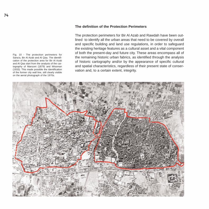
The definition of the Protection Perimeters
The protection perimeters for Bir Al Azab and Rawdah have been out-lined to identify all the urban areas that need to be covered by overalland specific building and land use regulations, in order to safeguardthe existing heritage features as a cultural asset and a vital componentof both the present-day and future city. These areas encompass all ofthe remaining historic urban fabrics, as identified through the analysisof historic cartography and/or by the appearance of specific culturaland spatial characteristics, regardless of their present state of conser-vation and, to a certain extent, integrity.
74
Fig. 10 - The protection perimeters forSana'a, Bir Al Azab and Al Qaa. The identifi-cation of the protection area for Bir Al Azaband Al Qaa start from the analysis of the car-tography of Manzoni (1879) and Wissman(1933). This made possible the identificationof the former city wall line, still clearly visibleon the aerial photograph of the 1970s.
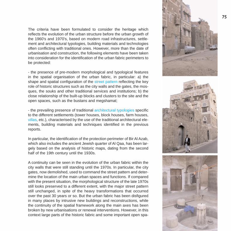
75
The criteria have been formulated to consider the heritage whichreflects the evolution of the urban structure before the urban growth ofthe 1960's and 1970's, based on modern road infrastructures, settle-ment and architectural typologies, building materials and technologiesoften conflicting with traditional ones. However, more than the date ofurbanisation and construction, the following elements have been takeninto consideration for the identification of the urban fabric perimeters tobe protected:
- the presence of pre-modern morphological and typological featuresin the spatial organisation of the urban fabric, in particular: a) theshape and spatial configuration of the street pattern reflecting the keyrole of historic structures such as the city walls and the gates, the mos-ques, the souks and other traditional services and institutions; b) theclose relationship of the built-up blocks and clusters to the site and theopen spaces, such as the bustans and megshamat;
- the prevailing presence of traditional architectural typologies specificto the different settlements (tower houses, block houses, farm houses,villas, etc.), characterised by the use of the traditional architectural ele-ments, building materials and techniques identified in the previousreports.
In particular, the identification of the protection perimeter of Bir Al Azab,which also includes the ancient Jewish quarter of Al Qaa, has been lar-gely based on the analysis of historic maps, dating from the secondhalf of the 19th century until the 1930s.
A continuity can be seen in the evolution of the urban fabric within thecity walls that were still standing until the 1970s. In particular, the citygates, now demolished, used to command the street pattern and deter-mine the location of the main urban spaces and functions. If comparedwith the present situation, the morphological structure of the late 1970sstill looks preserved to a different extent, with the major street patternstill unchanged, in spite of the heavy transformations that occurredover the past 30 years or so. But the urban fabric has been disfiguredin many places by intrusive new buildings and reconstructions, whilethe continuity of the spatial framework along the main axes has beenbroken by new urbanisations or renewal interventions. However, in thiscontext large parts of the historic fabric and some important open spa-
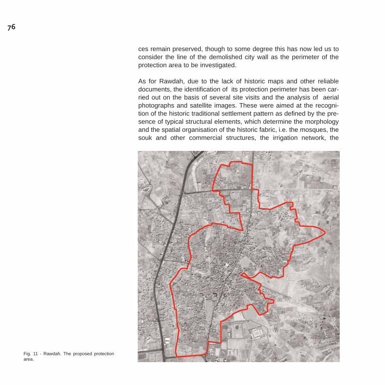
ces remain preserved, though to some degree this has now led us toconsider the line of the demolished city wall as the perimeter of theprotection area to be investigated.
As for Rawdah, due to the lack of historic maps and other reliabledocuments, the identification of its protection perimeter has been car-ried out on the basis of several site visits and the analysis of aerialphotographs and satellite images. These were aimed at the recogni-tion of the historic traditional settlement pattern as defined by the pre-sence of typical structural elements, which determine the morphologyand the spatial organisation of the historic fabric, i.e. the mosques, thesouk and other commercial structures, the irrigation network, the
76
Fig. 11 - Rawdah. The proposed protectionarea.

77
bustan and mekshamat. Also considered were the spatial articulationof the residential clusters, their relationship to the site, and the mainenvironmental features, like the wadi.
Therefore, a large protection perimeter was proposed which includesthe denser urban fabric along the main axis of the ancient souks, par-tially redeveloped in the last decades to form a new thoroughfare, anda series of traditional residential clusters surrounded by gardens andagricultural lands closely connected by a continuous and consistentstreet network.
In both cases, the protection areas are far from being homogeneous.They comprise settlements of high historic interest and cultural values,whose fabric deserves to be preserved and rehabilitated, as well asother surrounding or interstitial areas with no specific interest andvalues that may even be considered as intrusions and disruptions. Onthe other hand, due to the recent and ongoing processes of urbanisa-tion, the historic fabric often merges with new urban patterns, makingthe usual concept of a "buffer zone" difficult to apply.The protection perimeters are therefore larger than the remaininghistoric settlements of heritage interest, and respond to the fundamen-tal goal of defining the areas where an overall conservation and reha-bilitation policy is needed, not only to preserve the current heritage fea-tures, but also to prevent other building or infrastructure interventions,which may definitely affect their role and meaning in the urban context,and ultimately reduce their importance as a resource for sustainablesocio economic development.These perimeters would thus represent the necessary planning con-text to undertake a conservation policy, which has to be eventually arti-culated zone by zone with specific building and land use regulations,according to the different degree of heritage interest and cultural valueof the urban fabric.
The identification of the survey zones for the inventory
Due to the impacts of the modernisation and urbanisation process, theareas within these protection perimeters show different degrees ofintegrity and authenticity. Hence, for the sake of the inventory, the fol-lowing types of situations have been recognized, on the basis of sitevisits and analysis:
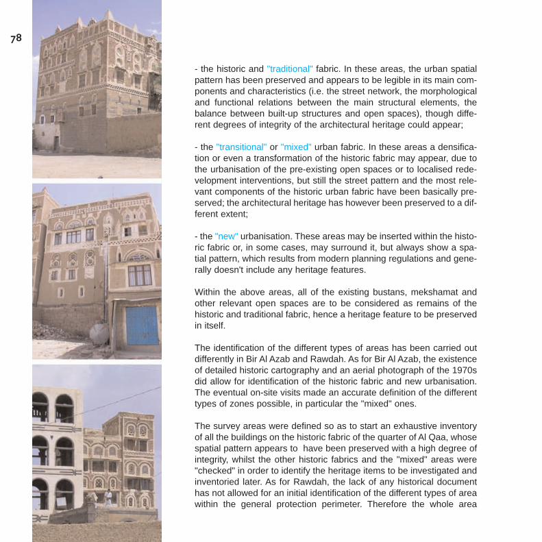
- the historic and "traditional" fabric. In these areas, the urban spatialpattern has been preserved and appears to be legible in its main com-ponents and characteristics (i.e. the street network, the morphologicaland functional relations between the main structural elements, thebalance between built-up structures and open spaces), though diffe-rent degrees of integrity of the architectural heritage could appear;
- the "transitional" or "mixed" urban fabric. In these areas a densifica-tion or even a transformation of the historic fabric may appear, due tothe urbanisation of the pre-existing open spaces or to localised rede-velopment interventions, but still the street pattern and the most rele-vant components of the historic urban fabric have been basically pre-served; the architectural heritage has however been preserved to a dif-ferent extent;
- the "new" urbanisation. These areas may be inserted within the histo-ric fabric or, in some cases, may surround it, but always show a spa-tial pattern, which results from modern planning regulations and gene-rally doesn't include any heritage features.
Within the above areas, all of the existing bustans, mekshamat andother relevant open spaces are to be considered as remains of thehistoric and traditional fabric, hence a heritage feature to be preservedin itself.
The identification of the different types of areas has been carried outdifferently in Bir Al Azab and Rawdah. As for Bir Al Azab, the existenceof detailed historic cartography and an aerial photograph of the 1970sdid allow for identification of the historic fabric and new urbanisation.The eventual on-site visits made an accurate definition of the differenttypes of zones possible, in particular the "mixed" ones.
The survey areas were defined so as to start an exhaustive inventoryof all the buildings on the historic fabric of the quarter of Al Qaa, whosespatial pattern appears to have been preserved with a high degree ofintegrity, whilst the other historic fabrics and the "mixed" areas were"checked" in order to identify the heritage items to be investigated andinventoried later. As for Rawdah, the lack of any historical documenthas not allowed for an initial identification of the different types of areawithin the general protection perimeter. Therefore the whole area
78
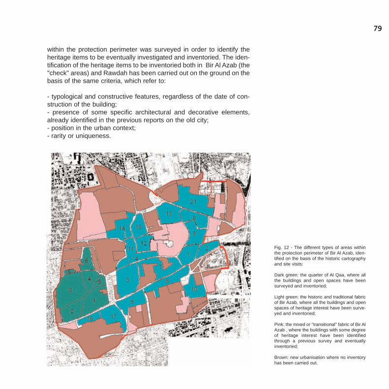
79
within the protection perimeter was surveyed in order to identify theheritage items to be eventually investigated and inventoried. The iden-tification of the heritage items to be inventoried both in Bir Al Azab (the"check" areas) and Rawdah has been carried out on the ground on thebasis of the same criteria, which refer to:
- typological and constructive features, regardless of the date of con-struction of the building;- presence of some specific architectural and decorative elements,already identified in the previous reports on the old city;- position in the urban context;- rarity or uniqueness.
Fig. 12 - The different types of areas withinthe protection perimeter of Bir Al Azab, iden-tified on the basis of the historic cartographyand site visits:
Dark green: the quarter of Al Qaa, where allthe buildings and open spaces have beensurveyed and inventoried;
Light green: the historic and traditional fabricof Bir Azab, where all the buildings and openspaces of heritage interest have been surve-yed and inventoried;
Pink: the mixed or "transitional" fabric of Bir AlAzab , where the buildings with some degreeof heritage interest have been identifiedthrough a previous survey and eventuallyinventoried;
Brown: new urbanisation where no inventoryhas been carried out.
The field survey
The Inventory of Bir Al Azab and Rawdah was performed through anextensive field survey covering the proposed protection perimeters.With only the exception of the Al Qaa district in Bir Al Azab, where allthe buildings were taken in to consideration, the survey has been car-ried out in three phases17:
- the first was dedicated to the identification of the heritage items,which were recorded on a table and on the available base map. As aresult, each item was given an ID number and the base map wasappropriately updated manually. At the same time, an initial evaluationof the level of interest was made on the basis of some pre-establishedcriteria18;- the second was dedicated to the drawing up of the survey sheet foreach item, which was completed with an exhaustive photographiccampaign;- the third consisted of office work dedicated to the review of the sur-vey sheets, preparation of the updated digitised map, downloading andclassification of the photographs and data entry from the revisedsheets, in order to create the inventory data base.
Similarly, the survey sheet for the bustans, mekshamat and other rele-vant open spaces includes the following information:
- identification of the open space, as above;- property, typology and use of the space, as above. In particular, thisis intended to identify the type of space (Bustan, Mekshamat andothers), as well as the type of use and prevailing vegetation;- fencing: this section includes information on the fencing walls, whenexisting: materials and specific interventions required;- Irrigation: this section includes information on the type of watersupply and irrigation system;- state of conservation and level of heritage interest. This section requi-res an overall evaluation of the general condition of the open spaceand of its cultural interest.In both cases, an additional section is dedicated to the tentative defi-nition of the required types of interventions, to be eventually verified forthe sake of the building regulations to be integrated in the conserva-tion and rehabilitation plan.
80
17 The field survey for Bir Al Azab andRawdah was undertaken by UNESCO - CLTand GOPHCY with the help of a group of 18Italian and Yemeni students, assisted andcoordinated by the international team ofexperts, Prof. Daniele Pini and architectsLuca Lanzoni and Saveria Teston of theFacoltà di Architettura of Ferrara, and theProf. Abdallah Al Adbeen of the Departmentof Architecture of the University of Sana'a.The survey was then finalised and theInventory implemented by the Yemeni stu-dents under the guidance of Saveria Testonand the team of GOPHCY. For the technicalprocedures of the preparation and organisa-tion of the survey and the implementation ofthe Inventory, see: Saveria Teston, MissionReport, UNESCO - Division of CulturalHeritage, July / September 2005.
18 As for the initial identification of the heri-tage items in Bir Al Azab and Rawdah, it mustbe stressed however that the general criteriahave been adopted to include in the surveyall the items which could show the least ele-ment of interest.
81
The criteria of evaluation
As in the case of Old Sana'a, these two survey sheets have beenadapted to the different characteristics of Bir Al Azab and Rawdah, andare basically structured to be filled in by the simple identification andassessment of the actual features of buildings and open spaces.However they include an evaluation exercise19 dealing with the follo-wing aspects:
- the conditions and the state of repair;- the level of heritage interest.
The criteria below have been proposed and tested through numerouson-site visits with all the experts and the student surveyors, for both thebuildings and the open spaces. Whilst the criteria used to classify the"conditions and the state of conservation" are the same as adopted forthe Old City, the evaluation of the "level of heritage interest" proceedsfrom different considerations. It reflects and synthesises a judgementon the architectural and heritage values that in the Old City was analy-tically based on the record of all the composition, constructive anddecorative elements, according to the "vocabulary" provided by the"handbook". Since the same method could not be applied, due to thelimited resources and time framework, a general evaluation has beengiven considering the following aspects:
- the authenticity and integrity of the typological and architectural fea-tures, as well as the quality and the wealth of the spatial, structural andformal composition, the construction details and finishes, the decora-tion, etc.;
- the position and the uniqueness of the building in relationto its urbancontext;
- the historic values and all the other elements (including symbolic andrepresentative meanings), which may lead to the identification of thebuilding as a heritage item.
On these bases, the buildings were classified by the surveyors accor-ding to the following categories, regardless of the typology and use:
19 These evaluations were carried out on siteby each team of surveyors and the assistingexpert, and later verified in the office, with thehelp of the photographs, and comparing themost controversial cases with the otherteams and experts.

- high: when a building of high architectural quality, with a high level ofintegrity, stands out in the urban context and/or represents a distin-guished example of a specific typology;
- medium: when a building of relevant architectural quality, whosestructure has been affected by recent transformations, still fits in theurban context as a historic or traditional feature;
- low: when a building of poor architectural quality still presents somehistoric or traditional features and dose not represent an intrusion intothe urban context.
For all the other matters, the same methods and criteria have beenused that were already established in the Old City inventory.
82
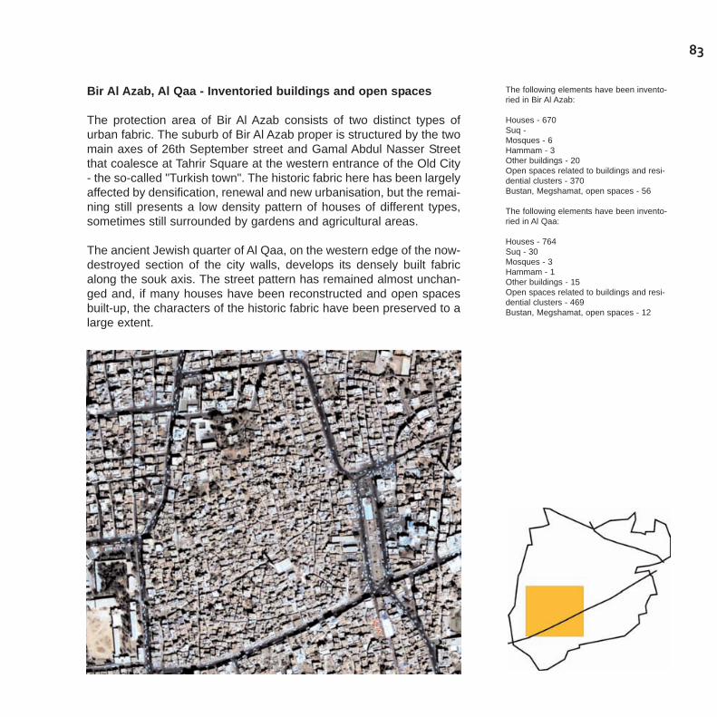
83
Bir Al Azab, Al Qaa - Inventoried buildings and open spaces
The protection area of Bir Al Azab consists of two distinct types ofurban fabric. The suburb of Bir Al Azab proper is structured by the twomain axes of 26th September street and Gamal Abdul Nasser Streetthat coalesce at Tahrir Square at the western entrance of the Old City- the so-called "Turkish town". The historic fabric here has been largelyaffected by densification, renewal and new urbanisation, but the remai-ning still presents a low density pattern of houses of different types,sometimes still surrounded by gardens and agricultural areas.
The ancient Jewish quarter of Al Qaa, on the western edge of the now-destroyed section of the city walls, develops its densely built fabricalong the souk axis. The street pattern has remained almost unchan-ged and, if many houses have been reconstructed and open spacesbuilt-up, the characters of the historic fabric have been preserved to alarge extent.
The following elements have been invento-ried in Bir Al Azab:
Houses - 670Suq - Mosques - 6Hammam - 3Other buildings - 20Open spaces related to buildings and resi-dential clusters - 370Bustan, Megshamat, open spaces - 56
The following elements have been invento-ried in Al Qaa:
Houses - 764Suq - 30Mosques - 3Hammam - 1Other buildings - 15Open spaces related to buildings and resi-dential clusters - 469Bustan, Megshamat, open spaces - 12
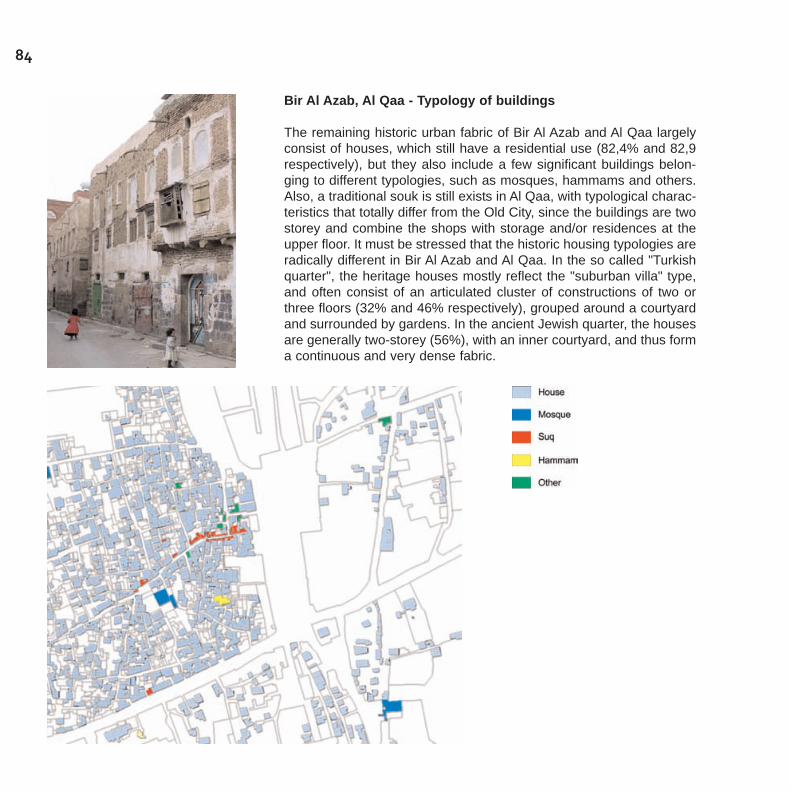
84
Bir Al Azab, Al Qaa - Typology of buildings
The remaining historic urban fabric of Bir Al Azab and Al Qaa largelyconsist of houses, which still have a residential use (82,4% and 82,9respectively), but they also include a few significant buildings belon-ging to different typologies, such as mosques, hammams and others.Also, a traditional souk is still exists in Al Qaa, with typological charac-teristics that totally differ from the Old City, since the buildings are twostorey and combine the shops with storage and/or residences at theupper floor. It must be stressed that the historic housing typologies areradically different in Bir Al Azab and Al Qaa. In the so called "Turkishquarter", the heritage houses mostly reflect the "suburban villa" type,and often consist of an articulated cluster of constructions of two orthree floors (32% and 46% respectively), grouped around a courtyardand surrounded by gardens. In the ancient Jewish quarter, the housesare generally two-storey (56%), with an inner courtyard, and thus forma continuous and very dense fabric.

85
Bir Al Azab, Al Qaa - Ownership
The large majority of the buildings are of private ownership (99% in AlQaa and 97% in Bir Al Azab), but the presence of some large and envi-ronmentally relevant open spaces belonging to public or waqf institu-tions has to be noted, since they represent a very important culturaland spatial asset.
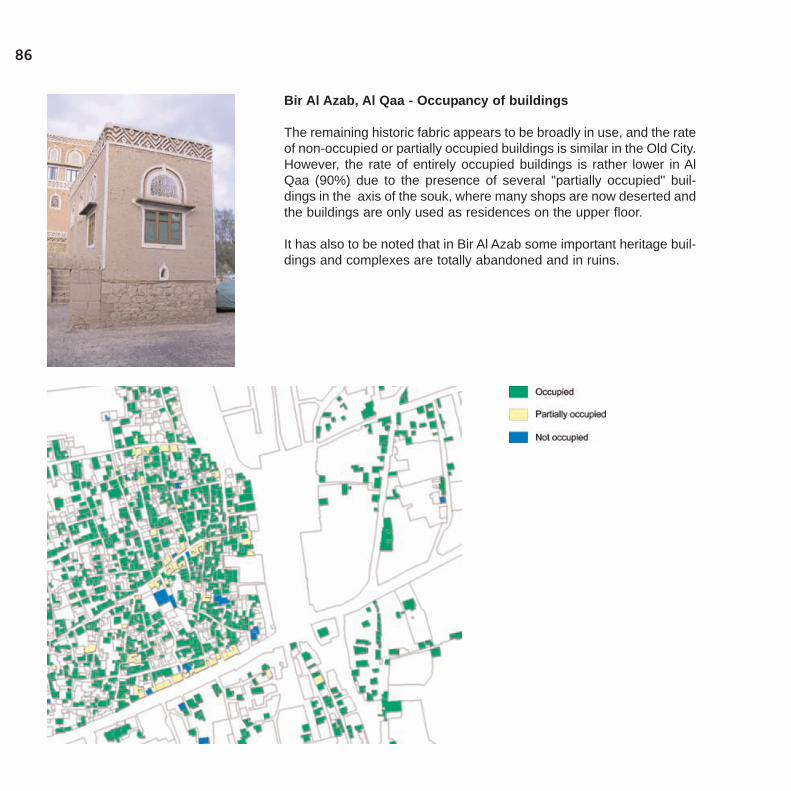
86
Bir Al Azab, Al Qaa - Occupancy of buildings
The remaining historic fabric appears to be broadly in use, and the rateof non-occupied or partially occupied buildings is similar in the Old City.However, the rate of entirely occupied buildings is rather lower in AlQaa (90%) due to the presence of several "partially occupied" buil-dings in the axis of the souk, where many shops are now deserted andthe buildings are only used as residences on the upper floor.
It has also to be noted that in Bir Al Azab some important heritage buil-dings and complexes are totally abandoned and in ruins.

87
Bir Al Azab, Al Qaa - Functions of buildings
Building use reflects the different functional structure of Bir Al Azab andthe old Jewish Quarter of Al Qaa. If the ratio of residential and mixeduses is about the same (82% and 13% respectively), the merely com-mercial buildings clearly define the central souk axis in Al Qaa, whilstthe many public and private services punctuate the urban fabric in BirAl Azab, particularly in the surroundings of Tahrir square.
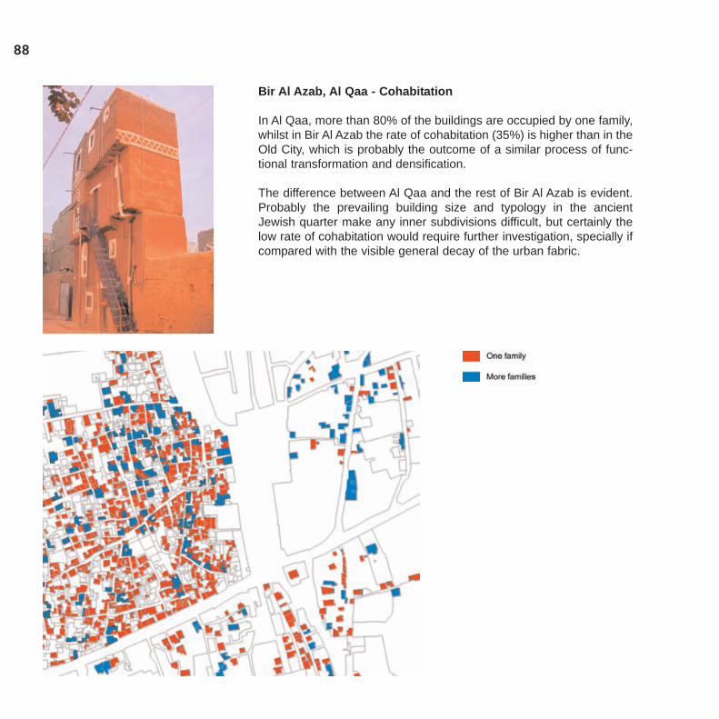
88
Bir Al Azab, Al Qaa - Cohabitation
In Al Qaa, more than 80% of the buildings are occupied by one family,whilst in Bir Al Azab the rate of cohabitation (35%) is higher than in theOld City, which is probably the outcome of a similar process of func-tional transformation and densification.
The difference between Al Qaa and the rest of Bir Al Azab is evident.Probably the prevailing building size and typology in the ancientJewish quarter make any inner subdivisions difficult, but certainly thelow rate of cohabitation would require further investigation, specially ifcompared with the visible general decay of the urban fabric.
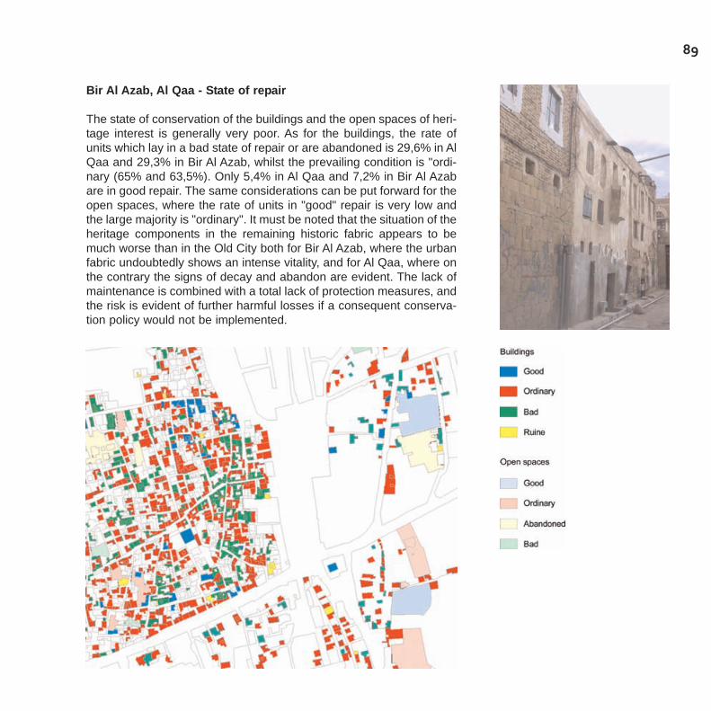
89
Bir Al Azab, Al Qaa - State of repair
The state of conservation of the buildings and the open spaces of heri-tage interest is generally very poor. As for the buildings, the rate ofunits which lay in a bad state of repair or are abandoned is 29,6% in AlQaa and 29,3% in Bir Al Azab, whilst the prevailing condition is "ordi-nary (65% and 63,5%). Only 5,4% in Al Qaa and 7,2% in Bir Al Azabare in good repair. The same considerations can be put forward for theopen spaces, where the rate of units in "good" repair is very low andthe large majority is "ordinary". It must be noted that the situation of theheritage components in the remaining historic fabric appears to bemuch worse than in the Old City both for Bir Al Azab, where the urbanfabric undoubtedly shows an intense vitality, and for Al Qaa, where onthe contrary the signs of decay and abandon are evident. The lack ofmaintenance is combined with a total lack of protection measures, andthe risk is evident of further harmful losses if a consequent conserva-tion policy would not be implemented.
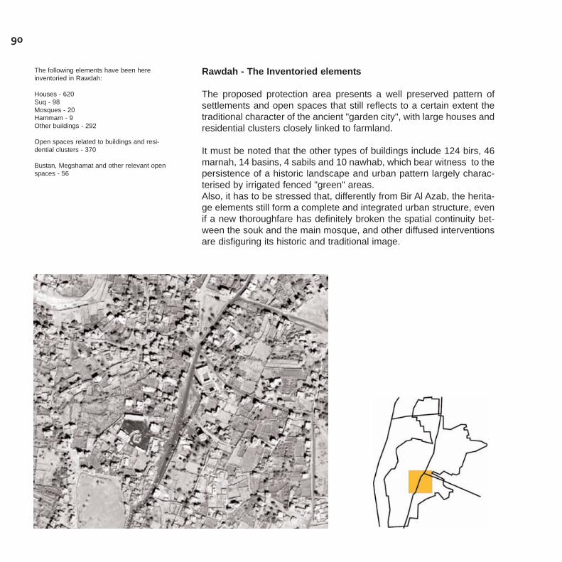
90
Rawdah - The Inventoried elements
The proposed protection area presents a well preserved pattern ofsettlements and open spaces that still reflects to a certain extent thetraditional character of the ancient "garden city", with large houses andresidential clusters closely linked to farmland.
It must be noted that the other types of buildings include 124 birs, 46marnah, 14 basins, 4 sabils and 10 nawhab, which bear witness to thepersistence of a historic landscape and urban pattern largely charac-terised by irrigated fenced "green" areas.Also, it has to be stressed that, differently from Bir Al Azab, the herita-ge elements still form a complete and integrated urban structure, evenif a new thoroughfare has definitely broken the spatial continuity bet-ween the souk and the main mosque, and other diffused interventionsare disfiguring its historic and traditional image.
The following elements have been hereinventoried in Rawdah:
Houses - 620Suq - 98Mosques - 20Hammam - 9Other buildings - 292
Open spaces related to buildings and resi-dential clusters - 370
Bustan, Megshamat and other relevant openspaces - 56

91
Rawdah - Typology of buildings
The historic urban fabric of Rawdah mostly consist of houses of diffe-rent types (60%), which still have a prevailing residential use, but dif-ferently from Bir Al Azab also include a large number of other types ofconstructions (28%), which are related to the irrigation and the main-tenance of the agricultural land and the gardens, such as bir, marnah,nawbah and so on.
Also, a traditional souk is still there, though in a very bad state of repair,whose units represent 9% of the heritage buildings and have typologi-cal characteristics similar to the Old City.It has to be noted that many of the existing religious, administrativeand commercial activities are still accommodated in buildings whichhave at least some heritage interest.
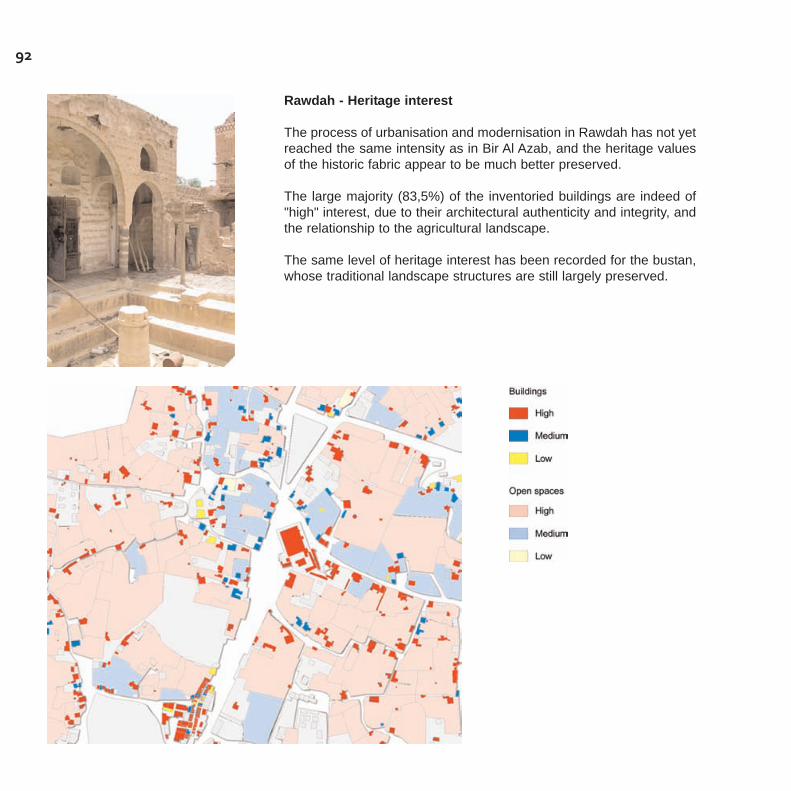
92
Rawdah - Heritage interest
The process of urbanisation and modernisation in Rawdah has not yetreached the same intensity as in Bir Al Azab, and the heritage valuesof the historic fabric appear to be much better preserved.
The large majority (83,5%) of the inventoried buildings are indeed of"high" interest, due to their architectural authenticity and integrity, andthe relationship to the agricultural landscape.
The same level of heritage interest has been recorded for the bustan,whose traditional landscape structures are still largely preserved.
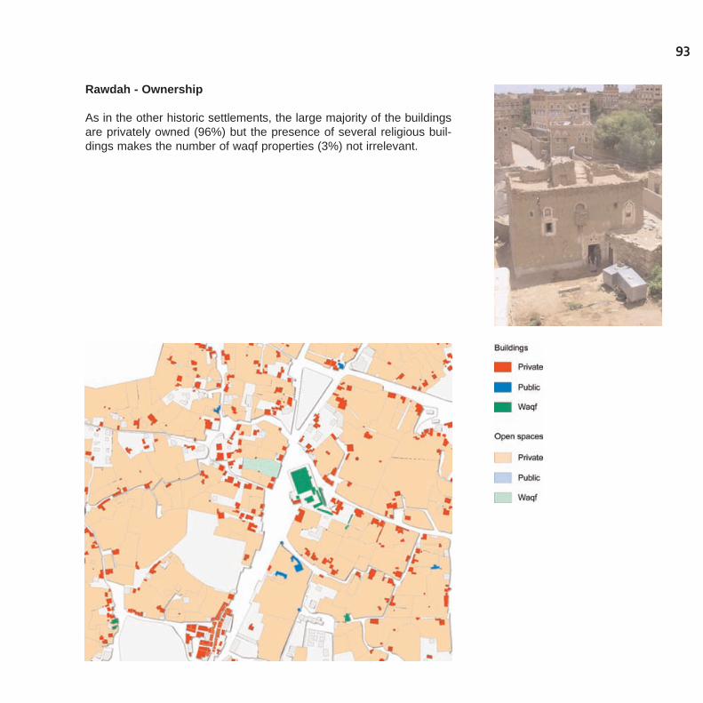
93
Rawdah - Ownership
As in the other historic settlements, the large majority of the buildingsare privately owned (96%) but the presence of several religious buil-dings makes the number of waqf properties (3%) not irrelevant.
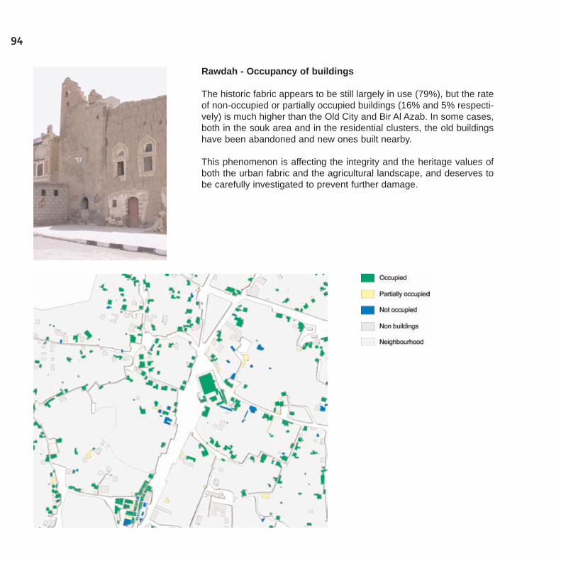
94
Rawdah - Occupancy of buildings
The historic fabric appears to be still largely in use (79%), but the rateof non-occupied or partially occupied buildings (16% and 5% respecti-vely) is much higher than the Old City and Bir Al Azab. In some cases,both in the souk area and in the residential clusters, the old buildingshave been abandoned and new ones built nearby.
This phenomenon is affecting the integrity and the heritage values ofboth the urban fabric and the agricultural landscape, and deserves tobe carefully investigated to prevent further damage.
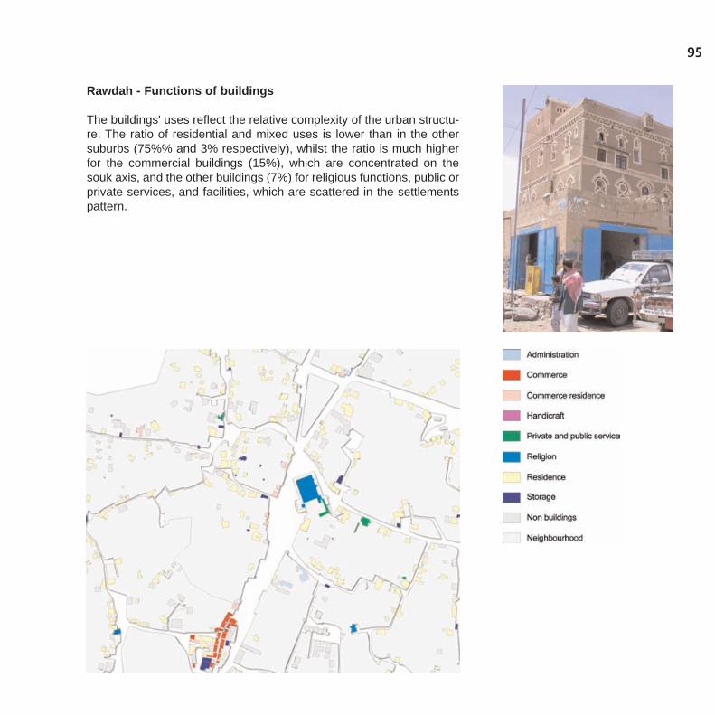
95
Rawdah - Functions of buildings
The buildings' uses reflect the relative complexity of the urban structu-re. The ratio of residential and mixed uses is lower than in the othersuburbs (75%% and 3% respectively), whilst the ratio is much higherfor the commercial buildings (15%), which are concentrated on thesouk axis, and the other buildings (7%) for religious functions, public orprivate services, and facilities, which are scattered in the settlementspattern.
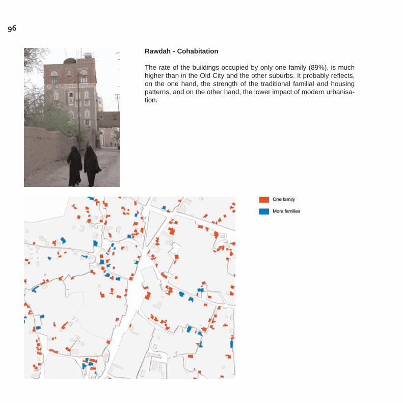
96
Rawdah - Cohabitation
The rate of the buildings occupied by only one family (89%), is muchhigher than in the Old City and the other suburbs. It probably reflects,on the one hand, the strength of the traditional familial and housingpatterns, and on the other hand, the lower impact of modern urbanisa-tion.
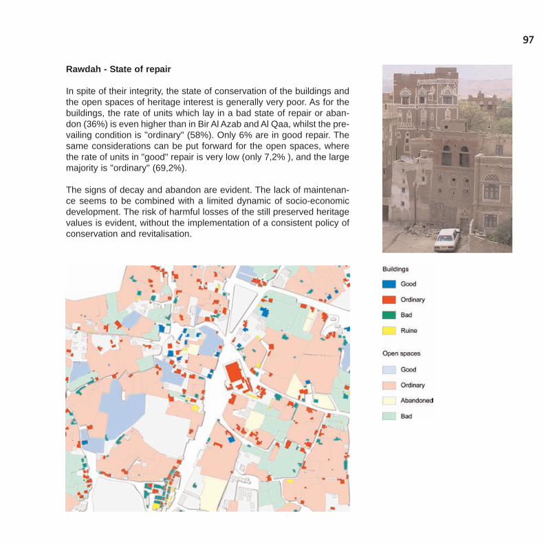
97
Rawdah - State of repair
In spite of their integrity, the state of conservation of the buildings andthe open spaces of heritage interest is generally very poor. As for thebuildings, the rate of units which lay in a bad state of repair or aban-don (36%) is even higher than in Bir Al Azab and Al Qaa, whilst the pre-vailing condition is "ordinary" (58%). Only 6% are in good repair. Thesame considerations can be put forward for the open spaces, wherethe rate of units in "good" repair is very low (only 7,2% ), and the largemajority is "ordinary" (69,2%).
The signs of decay and abandon are evident. The lack of maintenan-ce seems to be combined with a limited dynamic of socio-economicdevelopment. The risk of harmful losses of the still preserved heritagevalues is evident, without the implementation of a consistent policy ofconservation and revitalisation.
99
Toward the Conservation and Rehabilitation Plan forthe Greater Sana'a Historic Centres Conservation Plan
The decision to extend the implementation of protection measures toother historic settlements in the area of the Capital - besides the OldCity - has opened a new planning perspective. While it implies thatconservation becomes an issue for the larger urban area of Sana'a, italso calls for the definition of a strategic vision and appropriate plan-ning tools which include architectural heritage and the historic urbanfabric as a potential asset, not as a constraint, for sustainable deve-lopment. This requires the definition of a long-term and consistent con-servation strategy, which would consist of a well established regulatoryframework, and of a well-defined set of priority actions, in order toaddress the new challenges and issues which are imposed by theongoing processes of change.
On one hand, the Plan should be based on a broader concept of "heri-tage", which includes not only "monuments" and "remarkable buil-dings", but also their context, the "minor" and "vernacular" architectu-ral expressions, the articulation of the urban spaces and the landsca-pe features, according to the most advanced international "state of theart" practises in conservation. Obviously, this heritage can only be pre-served if life is kept in it, and functions and meanings are favoured,which are compatible with its characteristics, through the "adaptive"reuse of its different features. "Conservation" has therefore to beassociated with "rehabilitation" and the Plan also has to provide toolsfor protecting the heritage features from further deterioration, whilefavouring at the same time all the possible compatible interventions inthe Old City and in the other historic settlements, which can improvethe living conditions of the population and bring new activities anduses.
On the other hand, the Plan has to be closely linked, or integrated, intothe more general urban planning process, as a tool, which ensures thepreservation of the historical heritage within the framework of the futu-re urban development. Therefore, if it has to be based on the "inven-tories", which provide a clear identification of the heritage to be pre-
served, other studies and investigations are needed, which are intend-ed to offer an accurate description of the current situation and an out-line of the future trends and issues to be addressed, with regard to themorphological and functional structure of the different settlements, thesocio-economic condition, the "formal" (institutional) and "informal"structures that govern local traditional culture and activities, the hou-sing and real estate market, the environmental situation, the infra-structure network the municipal services, and so on.
On this basis, the Conservation and Rehabilitation Plan should definea strategy to give each historic centre an active role in the larger urbanarea, promoting their identity as a component of wider Sana'ni urbancivilisation. For this reason, the Plan should cover with the same levelof detail:
- the Old City - the World Heritage Site to be protected according to theinternational convention;- the historic fabrics identified and inventoried in the other centres - i.e.Bir el Azab and Rawdah, and eventually El Gabel village, Hadda villa-ge, Sana village, Attan village and Beit Bows village - to be protectedas an extension of the Old City.
From the technical point of view, the plan should include an appro-priate conservation and land-use zoning, with related building andplanning measures for each centre, in order to provide:
- the identification and classification of the zones to be submitted to thedifferent degrees and types of protection;- the identification and classification of the different types of buildingsand open spaces to be submitted to the different degrees and types ofprotection;- the establishment of a definite set of prescriptions and indications,including a land-use and building code to issue building permits andmonitor building activity, concerning: (a) all the existing building and/orarchitectural features and open spaces, for the Old City; (b) all the heri-tage buildings and open spaces to be identified for the other historiccentres;- the identification of the "sensitive areas" to be submitted to specialprojects of urban regeneration and rehabilitation.
100

101
Guidelines from the Inventories
Some guidelines for the preparation of the Plan can be drawn from theimplemented inventories. As for the identification of zones to be sub-mitted to different degrees of protection, it may be assumed that:
- the historic and "traditional" fabric should be considered as "conser-vation areas", to be preserved as a whole. Specific planning measuresshould be adopted in order to preserve the morphology, the spatial pat-tern and detailed building regulations which have to be established inorder to define the types of interventions appropriate for each building;
- the "mixed" or "transitional" fabrics can be considered as "urbanregeneration areas", where planning measures have to be adopted inorder to preserve the remaining historic spatial pattern and architectu-ral heritage. At the same time, these should address the negativeeffects of the densification and redevelopment interventions thatoccurred in the recent urbanisation process, whilst preventing furthertransformations that could eventually disfigure the remaining historicpattern;
- the newly urbanised and areas have to be considered as "bufferzones" where no interventions could be allowed that may cause furtherdecay to the urban fabric and prevent its conservation;- all the surviving bustan, mekshamat and other relevant open spaceshave to be considered as "no build" areas and be rehabilitated as spa-ces for agriculture and leisure.
The Inventories could also be used for the establishment of the gene-ral prescriptions concerning the types of interventions required oradmitted for each building, that can be defined as follows:
- restoration: this type of intervention is aimed at preserving and/orreconstituting the integrity of the typological and architectural featuresof the buildings or constructions of particularly high interest, whichhave a "monumental" character. This should be carried out on thebasis of an accurate information and documentation, including theanalysis of the historic evolution and a careful survey and diagnosis ofthe actual architectural structures. The same building materials andtechniques which characterise the historic structures have to be used,
in order to preserve the authenticity of the building. Only those usesshould be admitted, which are consistent with the preservation orreconstitution of the integrity and authenticity of the building;
- rehabilitation: this type of intervention is aimed at the preservation ofthe existing buildings or edifices of high interest, to make them availa-ble for the previous or new uses that are consistent with the typologi-cal and architectural features. The building structures can be adaptedto the new functional needs (inner distribution, equipment, etc.) withoutmajor changes to volume or to building height, the articulation of spa-ces, the façade composition, or the ornamentation layout. Buildingmaterials and techniques should be used which are consistent with thehistoric typological and architectural features;
- renovation: this category implies the conservation of the historic andtraditional structures as well as the partial restructuring or reconstruc-tion of an existing building, in order to make it available to previous ornew uses whilst improving the structural and functional conditions.Demolition and reconstruction is applied only to those parts, which areinconsistent with the historic and traditional typological and architectu-ral features. The existing buildings or constructions have to be madeavailable to previous or new uses with major changes to the currenttypological and architectural features (volume and building height,functional distribution and articulation of spaces, façade composition,ornamentation layout) using new but appropriate materials and buil-ding techniques, when needed. It is applied to all the buildings ofmedium or low interest, which have been heavily transformed but stillkeep some interesting architectural features, as well as to ordinarybuildings, which fit in to the historic or traditional urban context;
- reconstruction: this category implies the possibility to demolish andrebuild an existing building, respecting the land use and the typologi-cal and architectural features, in order to re-establish the continuity ofthe historic urban fabric (volume and building height, façade composi-tion and layout), with new appropriate materials and building techni-ques. In particular cases, to be defined by the Conservation Plan, thiscategory could imply the possibility to demolish and rebuild two ormore adjacent buildings with a new layout, respecting the specific landuse and building regulations to be established;
102
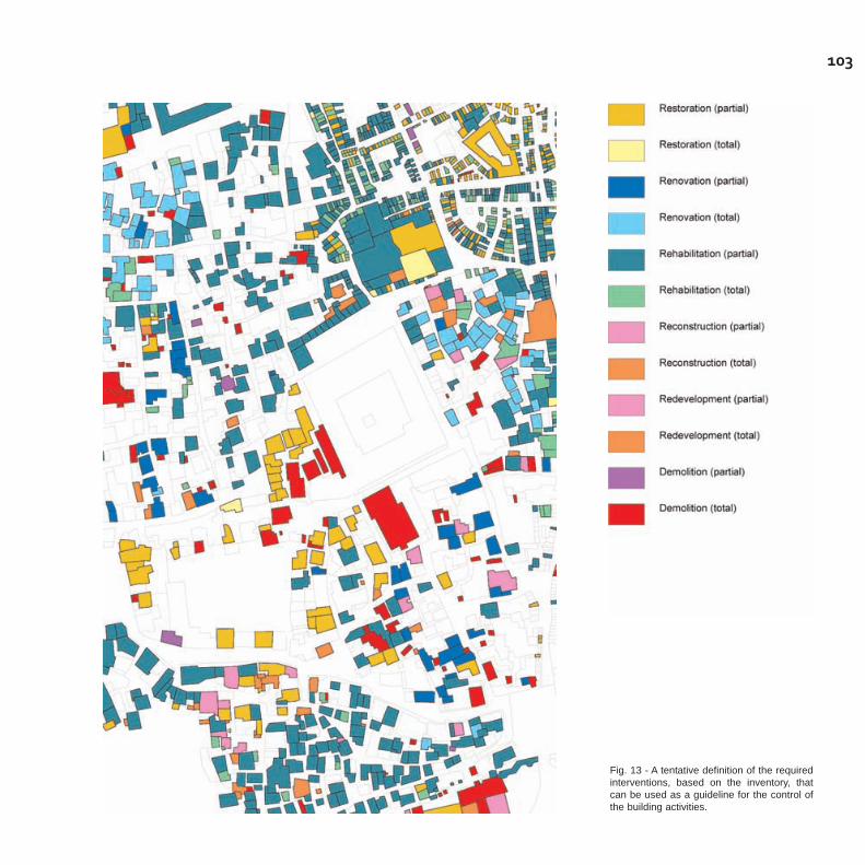
103
Fig. 13 - A tentative definition of the requiredinterventions, based on the inventory, thatcan be used as a guideline for the control ofthe building activities.

- demolition: this category applies to existing building (or a part of it) tobe demolished, without reconstruction or redevelopment of the land,which has to be made available for new landscape arrangements orurban infrastructure improvements.
Each of those interventions may be total or partial:
- total, when the entire building structure is affected by the interventionof recovery;- partial, if only a portion of the building - that could be a horizontaland/or vertical addiction, or simply an architectural element (like forinstance inconsistent plastering) - needs to be brought back to its ori-ginal and traditional characteristics.
The information provided by the inventories allows for the classificationof the buildings according to these categories, and it can be used bythe GOPHCY and the other concerned authorities as a guideline forcontrol against current building activities.
This could be the basis of a building regulation to be related to land-use prescriptions concerning uses and activities, and to be integratedby other prescriptions concerning the materials and building techni-ques. To this purpose, a clear definition is needed of "traditional" mate-rials and building techniques. "Tradition" indeed not only refers to "old"but also to "local": there are "old" materials and building techniquesthat could be inconsistent with the local "traditions", and on the otherhand, due to the complexity and the different degree of heritage valuesof the urban fabric, "modern" is not necessarily synonymous with"inconsistent": in many cases, it is the way "modern" materials areused that makes them inconsistent with the conservation objective.
A list of materials which refer to local Sana'ni architectural traditionshould be made, to be used in all interventions of restoration, refur-bishment and rehabilitation concerning the buildings inventoried as"monumental", "excellent" and "good" quality. However, the generalprinciple has to be asserted that all the existing "traditional" architec-tural elements, as identified by the survey and described in the inven-tory, have to be preserved and/or restored in any type of intervention,using appropriate materials and building techniques.
104

105
An agenda for the preparation of the Plan
In order to prepare and implement the plan the following, essentialtasks need to be accomplished:
- the constitution of a Sana'a conservation planning unit;- the use of inventories in the control and management of building acti-vities, and the development of the consequent actions to increase theawareness of Sana'a's architectural heritage preservation;- the development of sector studies and analyses on the current situa-tion and trends in the historic settlements;- the elaboration of the Conservation and Rehabilitation Plan docu-ments.
The establishment of a conservation planning unit has to be conside-red as a pre-condition for the implementation of any further works andfor the elaboration of the Plan documents. It should be created in theframework of the GOPHCY-CATS, with the support and the collabora-tion of the other national institutions involved in the Capital's urbanpolicies, i.e. the Capital Secretariat and others to be eventually identi-fied by the Yemeni authorities.
In this framework it would be possible for the GOPHCT to use theinventories as a tool for its inspection and building permissions deli-very, which is run in connection with the Urban Planning Departmentand the Municipality, as well as to raise awareness20. To this purposethe GIS database should be integrated with information concerning:
- violations (from GOPHCY);- building permissions (from the Municipality)- emergencies (from the Planning Department)
On the basis of the inventories and of the available documentation - tobe collected and organised by the Unit - the envisaged sectoral studiesand analysis could be undertaken, in order to outline the most relevantissues, and to provide the necessary information and conceptual fra-mework for the definition of an overall integrated conservation strategy.At this point, it is crucial to appraise the following aspects:
- the environmental situation, including the ecological conditions, the
20 The initial exploitation of the inventoriesdata allowed the organization of an exhibi-tion and a three day symposium on the out-comes of the survey, at the GOPHCY-CATSin August 2007, under the auspices of theMinistry of Culture, with the support of DED(German cooperation). Other initiatives areplanned at GOPHCY-CAT in order toincrease awareness amongst the public andthe officials.

infrastructural network, the municipal services;- the socio-economic conditions, aiming at the analysis of the socialstructures, the economic activities, the employment issues, the serviceand facilities available to the population;- the role of "formal" (institutional) and "informal" structures that governlocal traditional culture and activities; - the analysis of the different housing typologies and other buildingtypologies (i.e. commercial, religious buildings and others) which aimat identifying the current transformations being made by the inhabi-tants and users;- the analysis of morphological and functional structures of the differentresidential neighbourhoods and commercial districts;- the analysis of the housing and real estate market.
Further on, it will be possible to undertake the following tasks in orderto prepare the final documents of the conservation plan for all thehistoric settlements of the Greater Sana'a:
- definition of an overall and integrated conservation planning strategy;- elaboration of land use and conservation zoning with the identifica-tion and classification of the heritage areas and buildings to be sub-mitted to different degrees of protection, and related planning and buil-ding regulations;- identification and layout proposals of special action projects concer-ning the sensitive areas or the priority issues.
In the meanwhile it will be necessary to study the most appropriateinstitutional set-ups to enforce the conservation measures and inte-grate the Conservation and Rehabilitation Plan into the Greater Sana'aMaster Plan which is as yet to be finalised and approved.
106
107
Bibliography
Al-Abed, A.M. - Mustapha, F.H. (1996), "Satisfaction level with dwellingunit in low-Income public housing in Yemen", XXIVth IAHS WorldHousing Congress, Ankara, pp.981-92.
Audouin, R. - Saliba, H.P. (1998), "Rapport de Mission", UNESCO -WHC.
Berger/Kampsax (1978a), "Draft Final Report Sana'a Master Plan"V.B-II, Sana'a, Ministry of Urban Planning and Housing, Sana'a.
Berger/Kampsax (1978b), "Sana'a Master Plan", Vol. A, Sana'a,Ministry of Urban Planning and Housing, Sana'a.
Costa, P. -Vicario, E. (1977): Yemen, paese di costruttori, ElectaEditrice, Milano
Eckert, H. (1992), "The Chief Urban Functions of Old Sana'a" in "theCity of Sana'a Today", UNDP/YEM/88/006 Technical Report, Paris
Feiner, J. Paul (1997), "La vieille ville de Sana'a: analyse morphologi-que comme fondement de la sauvegarde patrimoniale", Thèse EcolePolytechnique Fédérale de Lausanne
Gilmore Hankey Kirke Ltd. in association with Pan Yemen ConsultingServices (1999), "Cultural Heritage (Protection) Project", Republic ofYemen, Ministry of Culture and Tourism, Sana'a
Lane, M.B. (1988): San'a'. "Pilot restoration projects for theInternational Campaign to Safeguard the Old City of San'a'", GOPHCY,UNDP-UNESCO, Paris
Lewcock, R.(1982): "The Campaign to Preserve the Old City ofSana'a," ICOMOS Paris

108
Lewcock, R. (1983): "The Old City of Sana'a", in Evin, A. (ed):Development and Urban Metamorphosis; Volume 1: Yemen at theCross-Roads, Concept Media/The Aga Khan Award for Architecture,Singapore
Lewcock, R. (1986): "The old walled city of San'a." Unesco, Paris
Lewcock, R. (1976): "Towns and Buildings in Arabia, North Yemen."Architectural Association Quarterly (London), Vol. VIII, No 1.
Matthews, H. (1980), "Building in the Yemen: Report on theProceedings Held at the Bouwcentrum", Bouwcentrum andInformation Centre for School Building and Museum of Ethnography,Rotterdam.
Pini, D. - Miglioli, F. (2003), "Mission Report", UNESCO - WHC, Paris.
Pini, D. (2005), "Mission Report", UNESCO - CLT/CH, Paris.
Serjeant, R.B. (1980): "The Islamic City: Selected Papers from theColloquium held at the Middle East Centre", Faculty of OrientalStudies, Cambridge. Paris, Unesco, 1980. Part I, Social Stratificationin Arabia (R.B. Serjeant); Part II, San''a' (Paolo M. Costa).
Serjeant, R.B. - Lewcock, R. (1983), Sana'a: An Arabian Islamic City,The World of Islam Festival Trust, London.
UNESCO, UNDP (1996): "Preservation of the Old City of Sana'a.Project findings and Recommendations", Paris.
Varanda, F. (1994), "Art of Building in Yemen." Ph.D diss., University ofDurham.