the impacts of land-use changes on the recovery of saltmarshes in portugal
TRANSCRIPT
lable at ScienceDirect
Ocean & Coastal Management 92 (2014) 40e49
Contents lists avai
Ocean & Coastal Management
journal homepage: www.elsevier .com/locate/ocecoaman
The impacts of land-use changes on the recovery of saltmarshes inPortugal
Diana Almeida a,*, Carlos Neto a, Luciana S. Esteves b, José Carlos Costa c
aCentro de Estudos Geográficos, Instituto de Geografia e Ordenamento do Território, Universidade de Lisboa, Alameda da Universidade, Ed. Faculdade deLetras, 1600-214 Lisboa, Portugalb Faculty of Science and Technology, Bournemouth University, Talbot Campus, Fern Barrow, Poole, Dorset BH125BB, United KingdomcCentro de Botânica Aplicada à Agricultura, Instituto Superior de Agronomia, Universidade de Lisboa, Tapada da Ajuda, 1349-017 Lisboa, Portugal
a r t i c l e i n f o
Article history:Available online 27 February 2014
* Corresponding author. Tel.: þ351 217 940 218.E-mail addresses: [email protected],
(D. Almeida), [email protected] (C. Neto), lestS. Esteves), [email protected] (J.C. Costa).
http://dx.doi.org/10.1016/j.ocecoaman.2014.02.0080964-5691/� 2014 Elsevier Ltd. All rights reserved.
a b s t r a c t
Human-induced land-use changes have resulted in loss and degradation of intertidal environmentsworldwide. Saltmarsh ecosystem dynamics in Portugal are greatly influenced by historic uses andconsequent habitat degradation. This study uses an original approach combining vegetation surveys andspatial analysis of historic maps and aerial photographs to assess the effects of land use changes onsaltmarshes in two areas in the Algarve, southern Portugal. Historical maps from c. 1800 and aerialphotographs from 1958 to 2010 were analyzed to map saltmarsh ecosystems and quantify land-usechanges in the Alvor estuary and Arade River. Between c. 1800 and 2010 more than half of saltmarsheswere lost due to dyke building and saltmarsh reclamation for agriculture. In mid-1960s, the abandon-ment of reclaimed agricultural areas resulted in the recolonization of saltmarsh vegetation, whichdeveloped physically separated from natural marshes. In the study area, these saltmarshes naturallyevolved into two distinct typologies: (1) enclosed mixed marshes, formed by patches of brackish,freshwater and some invasive species developing due to saline intrusion in areas where dykes have notbeen breached; and (2) tidally-restored saltmarshes, formed in areas where dyke breaching allowsincursion of tides and development of a vegetation structure similar to natural saltmarshes. In Europe,passive (without human intervention) and active (artificially planned) saltmarsh restoration are impor-tant mechanisms for voluntary or statutory re-creation of intertidal habitats. Improved understanding ofthe factors influencing the development of distinct saltmarsh typologies through passive ecosystemrecovery can provide new insights to support decision-making concerning intertidal habitat restoration.
� 2014 Elsevier Ltd. All rights reserved.
1. Introduction
Human-induced saltmarsh loss is widespread along the world’stemperate coasts (Moreira, 1986, 1992; Gu et al., 2007; Currin et al.,2008). Many studies have assessed the causes and consequences ofsaltmarsh loss (Eliot et al., 1999; Miller et al., 2001; Wu et al., 2002;Cahoon et al., 2006; Marfai and King, 2008), including in Portugal(Moreira, 1986; Ferreira et al., 2008). Degradation and loss of salt-marshes have major implications to their capacity of deliveringecosystem services, including: sediment accumulation; nutrientscycling; filtering of contaminants; wildlife habitat; flood regulation
[email protected]@bournemouth.ac.uk (L.
and storm protection (Simas et al., 2001; Currin et al., 2008; Feaginet al., 2010; Gedan and Bertness, 2010; Kim et al., 2011). Theextension, exposure and orientation of the saltmarsh in relation tothe coast, and the vegetation cover and maturity level of the plantcommunities influence the capacity to provide ecosystem services.
Environmental changes driven by natural processes, such as sea-level rise, have greatly affected saltmarshes (Simas et al., 2001;Morris et al., 2002; Gedan and Bertness, 2010; Mensah andFitzGibbon, 2012). However, human occupation in coastal areashas affected saltmarhes natural dynamics (Reeve andKarunarathna, 2009). In Europe, since the Middle Age, artificialmanipulation of these ecosystems often enhanced erosion ratesand resulted in substantial transformations in saltmarsh composi-tion, distribution and functions (Castillo et al., 2000; Mattheuset al., 2010; Gedan et al., 2011). These transformations increasedsaltmarshes vulnerability to environmental changes, reducing theirnatural adaptive capacity (French and Burningham, 2003; Gedan
D. Almeida et al. / Ocean & Coastal Management 92 (2014) 40e49 41
et al., 2009). The urban, touristic, industrial and agricultural usesalong the Portuguese coast have severely prevented the chances ofsaltmarsh recovery (Moreira, 1992; Rolo, 2007).
Natural saltmarsh evolution and diversity have been widelystudied (Moreira,1987; Costa and Lousã,1989; Leveuvre et al., 2000;Caçador et al., 2007; Deegan et al., 2012). More recently, studies havefocused on vegetation cover and species richness in embanked areas(Kleyer et al., 2003; Robinson et al., 2004; Bonisa et al., 2005) and as aresult of de-embankment (Garbutt and Wolters, 2008; Barkowskiet al., 2009). Such studies describe the effects of human interven-tion on the characteristics and recovery of saltmarshes and areimportant to informpractices andpolicyconcerning intertidalhabitatcreation (e.g. Habitat Directive objectives and/or to compensate forloss of protected areas) and their ability to deliver ecosystem services(Mossmanetal., 2012;SpencerandHarvey, 2012). In southernEurope(e.g. Portugal, Spain and France), economic drivers led to the aban-donment of agricultural practices in some areas, including coastalreclaimed land, creating opportunities for saltmarsh colonization(Boorman et al., 2002; Vélez-Martín et al., 2010).
This article assesses the effects of land use change on the evo-lution of secondary saltmarshes and describes the emerging distincttypologies using selected areas in the Algarve (Southern Portugal)as case study. A novel approach combining vegetation surveys andmapping of land-use changes based on analyses of historic mapsand aerial photography is used here to assess how historic land uses(from 1800s to 2010) contribute to the development of differentsaltmarsh typologies. The article first identifies the effects of humanactivities on saltmarsh dynamics along the Alvor estuary and theArade river mouth. Then results from spatial analysis of land usechanges and vegetation surveys are used to identify the main ty-pologies of recovered saltmarshes. The discussion focuses on thedrivers influencing unmanaged saltmarsh recovery under a Medi-terranean climate and highlights wider applications concerning therestoration of saltmarsh habitats. The article ends with a summaryof the main conclusions concerning the effects of land-use changeson the typology and development of secondary saltmarshes.
2. Study area
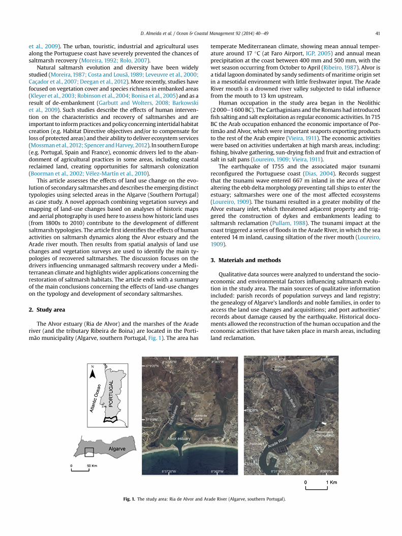
The Alvor estuary (Ria de Alvor) and the marshes of the Araderiver (and the tributary Ribeira de Boina) are located in the Porti-mão municipality (Algarve, southern Portugal, Fig. 1). The area has
Fig. 1. The study area: Ria de Alvor and Ara
temperate Mediterranean climate, showing mean annual temper-ature around 17 �C (at Faro Airport, IGP, 2005) and annual meanprecipitation at the coast between 400 mm and 500 mm, with thewet season occurring from October to April (Ribeiro, 1987). Alvor isa tidal lagoon dominated by sandy sediments of maritime origin setin a mesotidal environment with little freshwater input. The AradeRiver mouth is a drowned river valley subjected to tidal influencefrom the mouth to 13 km upstream.
Human occupation in the study area began in the Neolithic(2 000e1600BC). The Carthaginians and theRomanshad introducedfish salting and salt exploitation as regular economic activities. In 715BC the Arab occupation enhanced the economic importance of Por-timão and Alvor, which were important seaports exporting productsto the rest of the Arab empire (Vieira, 1911). The economic activitieswere based on activities undertaken at high marsh areas, including:fishing, bivalve gathering, sun-drying fish and fruit and extraction ofsalt in salt pans (Loureiro, 1909; Vieira, 1911).
The earthquake of 1755 and the associated major tsunamireconfigured the Portuguese coast (Dias, 2004). Records suggestthat the tsunami wave entered 667 m inland in the area of Alvoraltering the ebb delta morphology preventing tall ships to enter theestuary; saltmarshes were one of the most affected ecosystems(Loureiro, 1909). The tsunami resulted in a greater mobility of theAlvor estuary inlet, which threatened adjacent property and trig-gered the construction of dykes and embankments leading tosaltmarsh reclamation (Pullam, 1988). The tsunami impact at thecoast triggered a series of floods in the Arade River, inwhich the seaentered 14 m inland, causing siltation of the river mouth (Loureiro,1909).
3. Materials and methods
Qualitative data sources were analyzed to understand the socio-economic and environmental factors influencing saltmarsh evolu-tion in the study area. The main sources of qualitative informationincluded: parish records of population surveys and land registry;the genealogy of Algarve’s landlords and noble families, in order toaccess the land use changes and acquisitions; and port authorities’records about damage caused by the earthquake. Historical docu-ments allowed the reconstruction of the human occupation and theeconomic activities that have taken place in marsh areas, includingland reclamation.
de River (Algarve, southern Portugal).
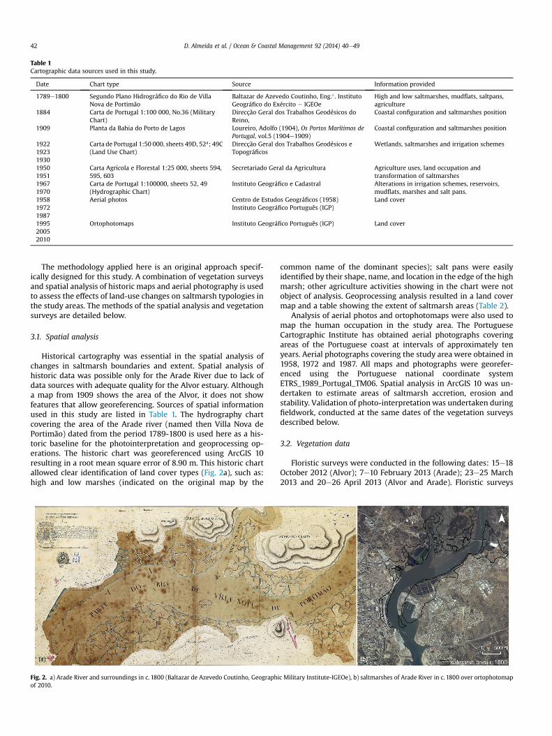
Table 1Cartographic data sources used in this study.
Date Chart type Source Information provided
1789e1800 Segundo Plano Hidrográfico do Rio de VillaNova de Portimão
Baltazar de Azevedo Coutinho, Eng.� . InstitutoGeográfico do Exército e IGEOe
High and low saltmarshes, mudflats, saltpans,agriculture
1884 Carta de Portugal 1:100 000, No.36 (MilitaryChart)
Direcção Geral dos Trabalhos Geodésicos doReino,
Coastal configuration and saltmarshes position
1909 Planta da Bahia do Porto de Lagos Loureiro, Adolfo (1904), Os Portos Marítimos dePortugal, vol.5 (1904e1909)
Coastal configuration and saltmarshes position
192219231930
Carta de Portugal 1:50 000, sheets 49D, 52a; 49C(Land Use Chart)
Direcção Geral dos Trabalhos Geodésicos eTopográficos
Wetlands, saltmarshes and irrigation schemes
19501951
Carta Agricola e Florestal 1:25 000, sheets 594,595, 603
Secretariado Geral da Agricultura Agriculture uses, land occupation andtransformation of saltmarshes
19671970
Carta de Portugal 1:100000, sheets 52, 49(Hydrographic Chart)
Instituto Geográfico e Cadastral Alterations in irrigation schemes, reservoirs,mudflats, marshes and salt pans.
195819721987
Aerial photos Centro de Estudos Geográficos (1958)Instituto Geográfico Português (IGP)
Land cover
199520052010
Ortophotomaps Instituto Geográfico Português (IGP) Land cover
D. Almeida et al. / Ocean & Coastal Management 92 (2014) 40e4942
The methodology applied here is an original approach specif-ically designed for this study. A combination of vegetation surveysand spatial analysis of historic maps and aerial photography is usedto assess the effects of land-use changes on saltmarsh typologies inthe study areas. The methods of the spatial analysis and vegetationsurveys are detailed below.
3.1. Spatial analysis
Historical cartography was essential in the spatial analysis ofchanges in saltmarsh boundaries and extent. Spatial analysis ofhistoric data was possible only for the Arade River due to lack ofdata sources with adequate quality for the Alvor estuary. Althougha map from 1909 shows the area of the Alvor, it does not showfeatures that allow georeferencing. Sources of spatial informationused in this study are listed in Table 1. The hydrography chartcovering the area of the Arade river (named then Villa Nova dePortimão) dated from the period 1789-1800 is used here as a his-toric baseline for the photointerpretation and geoprocessing op-erations. The historic chart was georeferenced using ArcGIS 10resulting in a root mean square error of 8.90 m. This historic chartallowed clear identification of land cover types (Fig. 2a), such as:high and low marshes (indicated on the original map by the
Fig. 2. a) Arade River and surroundings in c. 1800 (Baltazar de Azevedo Coutinho, Geographiof 2010.
common name of the dominant species); salt pans were easilyidentified by their shape, name, and location in the edge of the highmarsh; other agriculture activities showing in the chart were notobject of analysis. Geoprocessing analysis resulted in a land covermap and a table showing the extent of saltmarsh areas (Table 2).
Analysis of aerial photos and ortophotomaps were also used tomap the human occupation in the study area. The PortugueseCartographic Institute has obtained aerial photographs coveringareas of the Portuguese coast at intervals of approximately tenyears. Aerial photographs covering the study area were obtained in1958, 1972 and 1987. All maps and photographs were georefer-enced using the Portuguese national coordinate systemETRS_1989_Portugal_TM06. Spatial analysis in ArcGIS 10 was un-dertaken to estimate areas of saltmarsh accretion, erosion andstability. Validation of photo-interpretationwas undertaken duringfieldwork, conducted at the same dates of the vegetation surveysdescribed below.
3.2. Vegetation data
Floristic surveys were conducted in the following dates: 15e18October 2012 (Alvor); 7e10 February 2013 (Arade); 23e25 March2013 and 20e26 April 2013 (Alvor and Arade). Floristic surveys
c Military Institute-IGEOe), b) saltmarshes of Arade River in c. 1800 over ortophotomap
Table 2Land-cover/land-use changes over 1958 to 2010 in Alvor and Arade.
Covered area (ha)
Land cover 1958 1972 1987 1995 2005 2010
Alvor Arade Alvor Arade Alvor Arade Alvor Arade Alvor Arade Alvor Arade
Saltpans (working) 39 34 48 38 43 40 30 36 30 12 29 12Saltpans (abandoned) 0 0 0 0 24 0 44 0 25 22 36 4Aquaculture 0 0 0 0 0 0 9 11 21 29 20 48Saltmarsh early reclamation 44 120 0 0 0 0 0 0 0 0 0 0Saltmarsh in process of reclamation 41 0 6 70 0 67 0 0 0 0 0 0Salrmarsh (reclaimed) 84 120 161 70 45 67 24 13 55 27 47 49Saltmarsh (natural) 182 196 73 129 69 111 55 109 65 85 72 118Saltmarsh (dyked) 0 48 35 66 5 5 10 17 5 17 24 25Saltmash (recovered) 0 0 0 0 0 0 1 24 1 1 16 14Saltmash (eroded) 0 3 1 0 3 2 1 0 0 0 0 13Dykeland 134 211 128 153 125 151 2 36 2 70 65 30Dykeland (agriculture) 0 0 0 0 117 0 123 0 14 0 0 17Dykeland (abandoned) 0 0 0 0 24 0 243 121 237 139 188 167
D. Almeida et al. / Ocean & Coastal Management 92 (2014) 40e49 43
were conducted following the abundance/dominance scoresmethod (Braun-Blanquet, 1979) by using sampling quadrats of 2 m2
along selected transects. A total of 112 floristic surveys, amountingto 209 quadrats, were conducted in 15 randomly selected saltmarshareas (Table 3). The botanical nomenclature followed the works ofCastroviejo et al. (1986e2007), Franco (1971, 1984); Franco andRocha Afonso (1994, 1998, 2003) and Rivas-Martínez (2005). Thedegree of presence (Braun-Blanquet, 1979) was calculated to eval-uate the differences in species richness between saltmarsh areas(Table 4). The presence is estimated in percentages of a species andclassified according to a chosen scale into a set of ‘classes of pres-ence’. The classes were defined as follows (Costa et al., 2009): r(<6%); þ (6e10%); I (11e20%); II (21e40%); III (41e60%); IV (61e80%); V (>81%).
4. Results
The analysis of land cover c. 1800 (Fig. 2a) indicates that wet-lands have been progressively urbanized in the area of Portimão(Fig. 2b). Geoprocessing of historic maps revealed that saltmarshesoccupied an area of 242 ha c. 1800. Analyses of aerial photographyindicate that in 2010 the total area of saltmarshes was 118 ha.Therefore, 51% of saltmarshes in the Arade River mouth were lostbetween 1800 and 2010. Further analyses taking into account otherareas along the Arade River indicate that in total 65% of the salt-marshes were lost between 1800 and 2010. Reclaimed areas alongthe river Arade correspond to excavated old marshes, filled withestuarinemud and protected from tidal influence, with the purpose
Table 3Floristic surveys places by stage of saltmarsh transformation, location description and co
Stage of saltmarsh transformation River/Estuary Name of the
(1) Natural saltmarshes Arade Marine of M(1) Natural saltmarshes Companheir(1) Natural saltmarshes Arade tribu(3) Fragmented saltmarsh Alvor Right side o(2) Early reclamation West of the(4) Dyked saltmarshes Arade Dyked mars(4) Dyked saltmarshes Morgado de(4) Dyked saltmarshes Companheir(4) Dyked saltmarshes Alvor Quinta da R(6) Eroded saltmarshes Southwest A(4) Dyked saltmarshes Arade Companheir(5) Recovered saltmarshes Upstream le(5) Recovered saltmarshes Alvor Former agri(5) Recovered saltmarshes Maria Pires(6) Eroded saltmarshes Northeast Q
to create land for agriculture. Estuarine muds, nutrient-rich, wereused to fill the reclaimed saltmarsh and build dykes structuresupstream the Boina and along the left shore of the Arade River(Vieira, 1911).
4.1. Land-use changes between 1958 and 2010
Land-use changes in the period 1958 to 2010 highlight majortransformations in the wetlands (Fig. 3), especially concerningsaltmarsh reclamation for diverse economic activities (Table 2) andnatural ecosystem distribution and composition. Table 2 shows thedistribution in area of the saltmarsh sub-types and land uses in theAlvor estuary and Arade River identified though geoprocessing andphotointerpretation. Dykeland refers to areas enclosed by dykesand embankments, built to prevent tidal incursion.
One of the major land cover transformations was the saltpansabandonment. These complexes of salt production generally occu-pied large areas. The abandonment of the salt production occurred asthe traditional method for food preservation became less important,decreasing significantly the commercialization and export of salt(Rau, 1951). As a result saltpans were transformed into aquacultureproduction units starting around the mid-1980s in the Alvor and inthe early 2000s in the Arade. By 2010, about 59% of saltpans wereabandoned in the Alvor estuary and 85% in Arade river.
In 1958 natural saltmarshes occupied a slightly larger area inArade River (196 ha) than in the Alvor (182 ha), this relativeproportion was maintained throughout the studied period. TheAgriculture Development Plan was responsible for a 90% of the
ordinates.
place (village or site) Coordinates (WGS 84)
exelhoeira da Carregação N 37�08.9100 W 008�30.3110
a site N 37�09.5860 W 008�31.3760
tary: Ribeira de Boina N 37�10.2800 W 008�31.8610
f Odiáxere creek N 37�07.9910 W 008�37.4400
Alvor village N 37�07.5960 W 008�35.8710
hes at the left side of Arade River N 37�09.2720 W 008�30.0420
Arge (Boina creek) N 37�10.3350 W 008�31.9850
a dykedland N 37�09.6150 W 008�31.3720
ocha N 37�08.0560 W 008�36.9390
lvor estuary N 37�07.3250 W 008�38.0910
a inland N 37�09.6560 W 008�31.3820
ft side Arade N 37�09.6960 W 008�29.9920
culture dykeland upstream Alvor River N 37�08.5370 W 008�35.8410
N 37�08.6070 W 008�35.4640
uinta da Rocha N 37�08.1850 W 008�37.1190
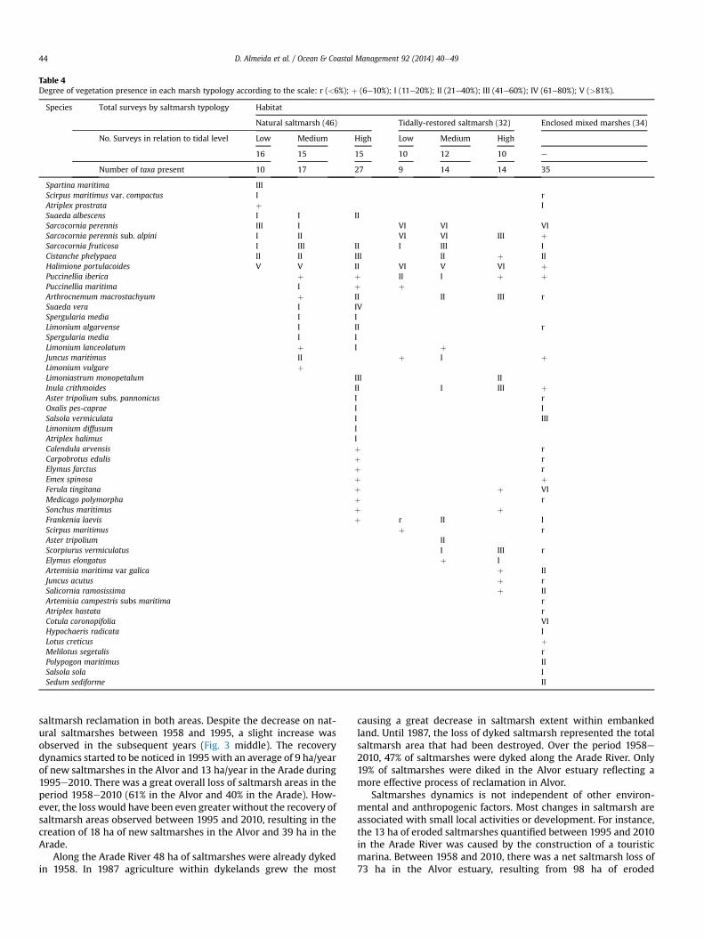
Table 4Degree of vegetation presence in each marsh typology according to the scale: r (<6%); þ (6e10%); I (11e20%); II (21e40%); III (41e60%); IV (61e80%); V (>81%).
Species Total surveys by saltmarsh typology Habitat
Natural saltmarsh (46) Tidally-restored saltmarsh (32) Enclosed mixed marshes (34)
No. Surveys in relation to tidal level Low Medium High Low Medium High
16 15 15 10 12 10 e
Number of taxa present 10 17 27 9 14 14 35
Spartina maritima IIIScirpus maritimus var. compactus I rAtriplex prostrata þ ISuaeda albescens I I IISarcocornia perennis III I VI VI VISarcocornia perennis sub. alpini I II VI VI III þSarcocornia fruticosa I III II I III ICistanche phelypaea II II III II þ IIHalimione portulacoides V V II VI V VI þPuccinellia iberica þ þ II I þ þPuccinellia maritima I þ þArthrocnemum macrostachyum þ II II III rSuaeda vera I IVSpergularia media I ILimonium algarvense I II rSpergularia media I ILimonium lanceolatum þ I þJuncus maritimus II þ I þLimonium vulgare þLimoniastrum monopetalum III IIInula crithmoides II I III þAster tripolium subs. pannonicus I rOxalis pes-caprae I ISalsola vermiculata I IIILimonium diffusum IAtriplex halimus ICalendula arvensis þ rCarpobrotus edulis þ rElymus farctus þ rEmex spinosa þ þFerula tingitana þ þ VIMedicago polymorpha þ rSonchus maritimus þ þFrankenia laevis þ r II IScirpus maritimus þ rAster tripolium IIScorpiurus vermiculatus I III rElymus elongatus þ IArtemisia maritima var galica þ IIJuncus acutus þ rSalicornia ramosissima þ IIArtemisia campestris subs maritima rAtriplex hastata rCotula coronopifolia VIHypochaeris radicata ILotus creticus þMelilotus segetalis rPolypogon maritimus IISalsola sola ISedum sediforme II
D. Almeida et al. / Ocean & Coastal Management 92 (2014) 40e4944
saltmarsh reclamation in both areas. Despite the decrease on nat-ural saltmarshes between 1958 and 1995, a slight increase wasobserved in the subsequent years (Fig. 3 middle). The recoverydynamics started to be noticed in 1995 with an average of 9 ha/yearof new saltmarshes in the Alvor and 13 ha/year in the Arade during1995e2010. There was a great overall loss of saltmarsh areas in theperiod 1958e2010 (61% in the Alvor and 40% in the Arade). How-ever, the loss would have been even greater without the recovery ofsaltmarsh areas observed between 1995 and 2010, resulting in thecreation of 18 ha of new saltmarshes in the Alvor and 39 ha in theArade.
Along the Arade River 48 ha of saltmarshes were already dykedin 1958. In 1987 agriculture within dykelands grew the most
causing a great decrease in saltmarsh extent within embankedland. Until 1987, the loss of dyked saltmarsh represented the totalsaltmarsh area that had been destroyed. Over the period 1958e2010, 47% of saltmarshes were dyked along the Arade River. Only19% of saltmarshes were diked in the Alvor estuary reflecting amore effective process of reclamation in Alvor.
Saltmarshes dynamics is not independent of other environ-mental and anthropogenic factors. Most changes in saltmarsh areassociated with small local activities or development. For instance,the 13 ha of eroded saltmarshes quantified between 1995 and 2010in the Arade River was caused by the construction of a touristicmarina. Between 1958 and 2010, there was a net saltmarsh loss of73 ha in the Alvor estuary, resulting from 98 ha of eroded
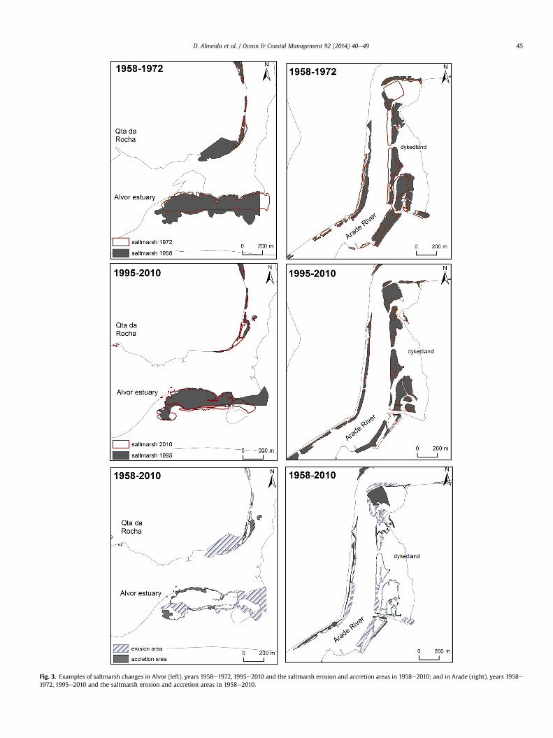
Fig. 3. Examples of saltmarsh changes in Alvor (left), years 1958e1972, 1995e2010 and the saltmarsh erosion and accretion areas in 1958e2010; and in Arade (right), years 1958e1972, 1995e2010 and the saltmarsh erosion and accretion areas in 1958e2010.
D. Almeida et al. / Ocean & Coastal Management 92 (2014) 40e49 45
D. Almeida et al. / Ocean & Coastal Management 92 (2014) 40e4946
saltmarshes and 25 ha of restored saltmarshes. For the same period,the Arade River showed a net saltmarsh gain of 12 ha, resultingfrom 14 ha of eroded saltmarshes and 26 ha of restoredsaltmarshes.
4.2. Saltmarshes typologies
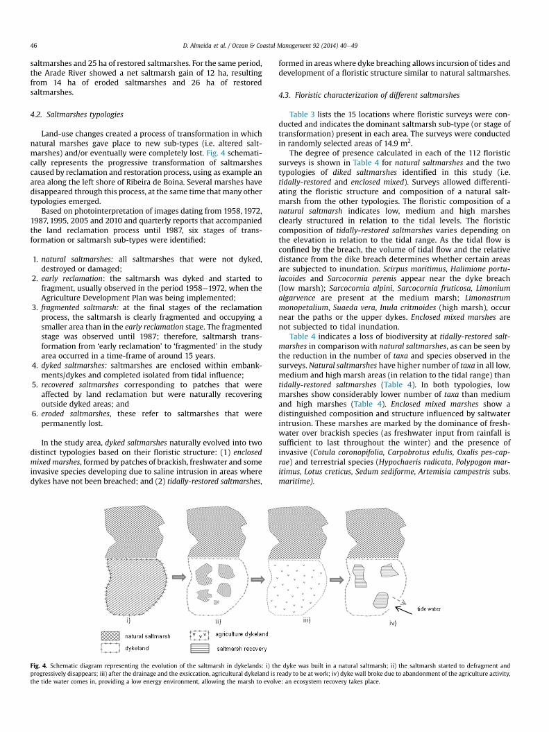
Land-use changes created a process of transformation in whichnatural marshes gave place to new sub-types (i.e. altered salt-marshes) and/or eventually were completely lost. Fig. 4 schemati-cally represents the progressive transformation of saltmarshescaused by reclamation and restoration process, using as example anarea along the left shore of Ribeira de Boina. Several marshes havedisappeared through this process, at the same time that many othertypologies emerged.
Based on photointerpretation of images dating from 1958, 1972,1987, 1995, 2005 and 2010 and quarterly reports that accompaniedthe land reclamation process until 1987, six stages of trans-formation or saltmarsh sub-types were identified:
1. natural saltmarshes: all saltmarshes that were not dyked,destroyed or damaged;
2. early reclamation: the saltmarsh was dyked and started tofragment, usually observed in the period 1958e1972, when theAgriculture Development Plan was being implemented;
3. fragmented saltmarsh: at the final stages of the reclamationprocess, the saltmarsh is clearly fragmented and occupying asmaller area than in the early reclamation stage. The fragmentedstage was observed until 1987; therefore, saltmarsh trans-formation from ‘early reclamation’ to ‘fragmented’ in the studyarea occurred in a time-frame of around 15 years.
4. dyked saltmarshes: saltmarshes are enclosed within embank-ments/dykes and completed isolated from tidal influence;
5. recovered saltmarshes corresponding to patches that wereaffected by land reclamation but were naturally recoveringoutside dyked areas; and
6. eroded saltmarshes, these refer to saltmarshes that werepermanently lost.
In the study area, dyked saltmarshes naturally evolved into twodistinct typologies based on their floristic structure: (1) enclosedmixed marshes, formed by patches of brackish, freshwater and someinvasive species developing due to saline intrusion in areas wheredykes have not been breached; and (2) tidally-restored saltmarshes,
Fig. 4. Schematic diagram representing the evolution of the saltmarsh in dykelands: i) thprogressively disappears; iii) after the drainage and the exsiccation, agricultural dykeland isthe tide water comes in, providing a low energy environment, allowing the marsh to evolv
formed in areas where dyke breaching allows incursion of tides anddevelopment of a floristic structure similar to natural saltmarshes.
4.3. Floristic characterization of different saltmarshes
Table 3 lists the 15 locations where floristic surveys were con-ducted and indicates the dominant saltmarsh sub-type (or stage oftransformation) present in each area. The surveys were conductedin randomly selected areas of 14.9 m2.
The degree of presence calculated in each of the 112 floristicsurveys is shown in Table 4 for natural saltmarshes and the twotypologies of diked saltmarshes identified in this study (i.e.tidally-restored and enclosed mixed). Surveys allowed differenti-ating the floristic structure and composition of a natural salt-marsh from the other typologies. The floristic composition of anatural saltmarsh indicates low, medium and high marshesclearly structured in relation to the tidal levels. The floristiccomposition of tidally-restored saltmarshes varies depending onthe elevation in relation to the tidal range. As the tidal flow isconfined by the breach, the volume of tidal flow and the relativedistance from the dike breach determines whether certain areasare subjected to inundation. Scirpus maritimus, Halimione portu-lacoides and Sarcocornia perenis appear near the dyke breach(low marsh); Sarcocornia alpini, Sarcocornia fruticosa, Limoniumalgarvence are present at the medium marsh; Limonastrummonopetalium, Suaeda vera, Inula critmoides (high marsh), occurnear the paths or the upper dykes. Enclosed mixed marshes arenot subjected to tidal inundation.
Table 4 indicates a loss of biodiversity at tidally-restored salt-marshes in comparisonwith natural saltmarshes, as can be seen bythe reduction in the number of taxa and species observed in thesurveys. Natural saltmarshes have higher number of taxa in all low,medium and high marsh areas (in relation to the tidal range) thantidally-restored saltmarshes (Table 4). In both typologies, lowmarshes show considerably lower number of taxa than mediumand high marshes (Table 4). Enclosed mixed marshes show adistinguished composition and structure influenced by saltwaterintrusion. These marshes are marked by the dominance of fresh-water over brackish species (as freshwater input from rainfall issufficient to last throughout the winter) and the presence ofinvasive (Cotula coronopifolia, Carpobrotus edulis, Oxalis pes-cap-rae) and terrestrial species (Hypochaeris radicata, Polypogon mar-itimus, Lotus creticus, Sedum sediforme, Artemisia campestris subs.maritime).
e dyke was built in a natural saltmarsh; ii) the saltmarsh started to defragment andready to be at work; iv) dyke wall broke due to abandonment of the agriculture activity,e: an ecosystem recovery takes place.
D. Almeida et al. / Ocean & Coastal Management 92 (2014) 40e49 47
5. Discussion
Land-use changes commonly result in erosion and degradationof marshes (Bertness and Silliman, 2008). Natural saltmarshes areresilient to various disturbances in their ecology or ecosystemsfunction (Roebeling et al., 2013) and they can respond positively tosea-level rise (Moreira, 1987). However, human occupation incoastal areas and the presence of hard engineering structuresprevent inland migration of the saltmarsh ecosystems. Economicinterests have been more important than the value or servicesoffered by saltmarshes. Historically, coastal wetlands were seen asland available at low price with a privileged location.
The Alvor dykes were built in the early 17th century with theobjective of supporting agricultural practices, e.g. by allowingfreshwater farm irrigation from the Alvor tributaries to the Mex-elhoeira Grande and Arão (Mariano, 2010). In Alvor, it was verycommon to artificially control tides along the tributary Ribeira deOdiáxere, in order to reclaimwetlands for agriculture. Two saltpansexisted in Portimão; one at west of the urban center and the otherin the north riverside, which progressively expanded towardsRibeira de Boina (Arade tributary).
Saltmarsh reclamation has occurred over a long period in thestudy area, but the greatest impacts arose by the implementation ofthe Portuguese Agriculture Development Plans (1953e1964),which targeted investments to stimulate economy. These Planswere implemented in two phases. The first phase (1953e1958)prioritized saltmarsh reclamation to create agricultural landthrough the construction of small embankments, clearing theoriginal vegetation and irrigation with freshwater. These activitiesprovided the leaching needed to avoid saltmarshes communities togrow. The second phase (1959e1964) focused on the exsiccation ofdyked saltmarshes by trenching. Land reclamation in study areaceased mainly due to the failure of the Portuguese AgricultureDevelopment Plans.
In many locations, the practices introduced by the PortugueseAgriculture Development Plans resulted in the destruction ofmarshlands beyond chances of restoration. Land reclamation foragricultural purposeswas very successful on upstream saltmarshes,where freshwater streams feeding the Alvor estuary (i.e. Odiáxere,Arão, Penina) were able to reduced saltwater intrusion. Currently,marsh vegetation is not seen in these agricultural fields (agriculturedykeland). Recovery of saltmarshes are highly hindered in areaswhere the abandonment of commercial salt production has beenreplacement by aquaculture and in areas developed for urban-tourist uses (Gedan et al., 2009).
In other locations, the great exsiccation works had limited suc-cess in creating agricultural areas. In the Alvor estuary, the influ-ence of saltwater intrusion allowed enclosed mixed marshes todevelop inside the dykelands. An important factor for the emer-gence of enclosed mixed marshes is the Mediterranean climate dryconditions, which favor salt intrusion by capillarity, as observed inthe areas of Maria Pires and Quinta da Rocha in the Alvor estuary. Inthe Arade River, the failure of agricultural dykelands is related tothe degradation of the embankments or the destruction of flood-gates, after economic practices (e.g. grazing, agriculture or saltproduction) were abandoned. In these areas, the natural breachingof abandoned embankments restored tidal flow into the dykelandsproviding opportunities for tidally restored saltmarsh communitiesto develop. The restoration of saltmarsh communities was favoredespecially in areas of high sedimentation rates.
Surveys show significant differences in floristic compositionbetween the primary (natural marsh) and the enclosed mixedmarshes that grow inside dykelands. Enclosed mixed marshes areformed by patches of brackish species (Haliminone portulacoides, S.fruticosa, Arthrocnemun macrostachium), within freshwater
communities (Puccinelia iberica, Juncus accutus, Scirpus compactus)presenting some invasive species (C. coronopifolia, C. edulis, Cis-tanche philipaea, O. pes-caprae (e.g. observed at Maria Pires salt-marsh in the Alvor). Mossman et al. (2012) suggest that “it isunlikely that restored marshes with very different vegetation will befunctionally equivalent” and discusses how floristic differencesmight affect different functions. Spencer and Harvey (2012) indi-cate that saltmarshes restored through active management (e.g.managed realignment) “may be significantly impaired” in their ca-pacity to deliver “ecosystem services including biodiversity, climateregulation and waste processing”.
Despite being impaired in their potential functionality whencompared to natural saltmarshes, secondary saltmarshes (e.g.tidally-restored or enclosed mixed marshes) are still able to offersome ecosystem services. It is therefore required that furtherstudies are able to quantify how functionally impaired restoredsaltmarshes might be and whether there are any ecosystem ser-vices they might not be able to provide. Nevertheless, especially forsaltmarshes restored unmanaged, it might be more pertinent tocompare their capacity to provide ecosystem services in relation tothe land-use/land-cover type they have replaced (e.g. abandonedagricultural land), rather than their equivalence to natural habitats.For example, enclosed mixed marshes tend to be sheltered,providing conditions for birds and other animals to feed and refugefrom predators; additionally, the saltmarshes enhance the ability tooffer storm protection. These services are better provided by therestored saltmarshes than the previous land cover/use. Furtherunderstanding the evolution and functionality of restored salt-marshes and the ecosystem services they are able to provide isrequired to inform coastal managers on the benefits gained (andlost) from this unmanaged land use/cover change.
Regardless of the great land use transformations described here,natural saltmarshes continue to exist in both the Alvor and Aradestudy areas. Facing this great diversity of saltmarshes typologies,dealing with habitat management is truly a challenge. Enclosedmixed marshes and tidally-restores saltmarshes have different re-covery rhythms mainly influenced by the previous land cover(economic activity) or by the stage of transformation at the time ofabandonment. The saltmarshes typologies differentiation revealedextremely useful to categorize vegetation succession, which formerstudies fail to address. The analysis of the effects of past anthro-pogenic occupation revealed the resilience of saltmarshes and theirability to recover without artificial intervention.
6. Conclusion
Persistent human occupation and land-use changes in Portugal,rather than sea-level rise or other environmental changes, havecaused the greatest impacts in coastal ecosystems in the last twocenturies. This study quantified losses and gains in saltmarsh areasand identified typologies resulting from responses to land-usechanges from 1800 to 2010 in the Arade River and Alvor estuary(Algarve, southern Portugal). A custom methodology involving acombination of spatial analysis (based on historic charts and aerialphotographs) and vegetation surveys was used to quantify changesand identify saltmarsh typologies.
Land reclamation for agriculture was promoted by nationalpolicies in the 1950s and 1960s resulting in an overall loss of 763 ha(85%) of saltmarshes in the study area between 1958 and 2010. Sixstages of transformation were identified associated with theresponse of natural saltmarshes to land reclamation. In the mid-1960s, economic drivers led to the abandonment of agriculturalpractices allowing saltmarsh recovery in reclaimed areas. Localparticularities resulted in the (unmanaged) development of twodistinguishable saltmarsh typologies: (1) enclosed mixed marshes
D. Almeida et al. / Ocean & Coastal Management 92 (2014) 40e4948
formed by patches of brackish, freshwater and some invasive spe-cies developed due to saline intrusion in areas where dykes havenot been breached; and (2) tidally-restored saltmarshes formed inareas where dyke breaching allowed incursion of tides and thedevelopment of a floristic structure similar to natural saltmarshes.
Over the 1958e2010 period, saltmarsh recovery in the AradeRiver is dominated by tidally-restored saltmarshes, while the Alvorestuary enclosed mixed marshes dominate. Identifying the differenttypologies of secondary saltmarshes helps inform managementpractices aiming to enhance environmental benefits. For example,it is necessary to identify and quantify the capacity of differenttypologies to deliver ecosystems services in order to inform man-agement efforts targeting enhancement of specific ecosystem ser-vices (e.g. carbon sequestration, flood riskmanagement etc.). In thisregard, for example, studies focusing on sediment dynamics inareas of tidally-restored saltmarshes and saltwater intrusionaffecting enclosed mixed marshes would contribute to further un-derstand the processes involved in the restoration of ecologicalfunctions in the study area and elsewhere.
The methodology used in this study proved appropriate toassess the response of saltmarshes to land-use changes. The sixtransformation stages and the two typologies of secondary salt-marshes identified in this study are likely to be found in other areasof Mediterranean climate (e.g. in Portugal, Spain and France). Thismethodology can be easily applicable to other locations worldwideproviding land-use changes have been recorded through time (e.g.in historic charts).
Acknowledgments
This work was developed under the financial support of thePortuguese Foundation for Science and Technology (FCT referenceSFRH/BD/77252/2011). We thank the support of Lieutenant ColonelJosé Bérger from the Gabinete de Estudos Arqueológicos daEngenharia Militar (GEAEM) in providing the cartographic materialavailable at the Instituto Geográfico do Exército (IGEOe). In thisregard we also thank Dr Paula Camacho (Direcção-Geral do Terri-tório, DGT) and Dr Sandra Domingues (Centre for GeographicalStudies of the University of Lisbon).
References
Barkowski, J., Kolditz, K., Brumsac, H., Freund, H., 2009. The impact of tidal inun-dation on salt marsh vegetation after de-embankment on Langeoog Island,Germanydsix years’ time series of permanent plots. J. Coast. Conserv. 13, 185e209. http://dx.doi.org/10.1007/s11852-009-0053-z.
Bertness, M.D., Silliman, B.R., 2008. Consumer control of salt marshes driven byhuman disturbance. Conserv. Biol. 22, 618e623.
Bonisa, A., Bouzille, J.-B., Amiauda, B., Loucougaray, G., 2005. Plant communitypatterns in old embanked grasslands and the survival of halophytic flora. Flora200, 74e87. http://dx.doi.org/10.1016/j.flora.2004.06.002.
Boorman, L., Hazelden, J., Boorman, M., 2002. New salt marshes for old e salt marshcreation and management. In: Littoral 2002, the Changing Coast. EUROCOAST/EUCC, Porto e Portugal, pp. 35e45.
Braun-Blanquet, J., 1979. Fitosociologia. In: Blume, H. (Ed.), Bases para el estudio delas comunidades vegetales (Madrid).
Caçador, I., Tibério, S., Cabral, H.N., 2007. Species zonation in Corroios salt marsh inthe Tagus estuary (Portugal) and its dynamics in the past fifty years. Hydro-biologia 587, 205e211. http://dx.doi.org/10.1007/s10750-007-0681-y.
Cahoon, D.R., Hensel, P.F., Spencer, T., Reed, D.J., Mckee, K.L., Saintilan, N., 2006.Coastal wetland vulnerability to relative sea-level rise: wetland elevationtrends and process controls. In: Verhoven, J., Beltman, B., Bobbink, R.,Whigam, D. (Eds.), Wetlands and Natural Resource Management, EcologicalStudies, vol. 190. Springer-Verlag, Berlin and Heidelberg, pp. 271e292.
Castillo, J., Luque, C., Castellanos, E., Figueroa, M., 2000. Causes and consequences ofsalt-marsh erosion in an Atlantic estuary in SW Spain. J. Coast. Conserv. 6, 89e96.
Castroviejo, S., Laínz, M., López González, G., Monserrat, P., Muñoz Garmendia, F.,PAIVA, J., Villar, L. (Eds.), 1986e2007. Flora Iberica, vol. IeVIII, X, XIV, XV, XVIII,XXI. Real Jardín Botánico de Madrid, CSIC, Madrid.
Costa, J.C., Lousã, M., 1989. Communautes Psammophiles et Halophiles du “Ria deAlvor”. Colloq. Phytosociol. XVIII, 119e135. Phytosociologie littorale et Tax-onomie. Bailleul 1989.
Costa, J.C., Neto, N., Arsénio, P., Capelo, J., 2009. Geographic variation among Iberiancommunities of the exotic halophyte Cotula coronopifolia. Bot. Helvetica 119,53e61. http://dx.doi.org/10.1007/s00035-009-0056-2.
Currin, C.A., Priscilla, A.E., Delano, C., 2008. Utilization of a citizen monitoringprotocol to assess the structure and function of natural and stabilized fringingsalt marshes in North Carolina. Wetl. Ecol. Manag. 16, 97e118.
Deegan, L., Johnson, D., Warren, S., Peterson, B., Fleeger, J., Fagherazzi, S.,Wollheim, W., 2012. Coastal eutrophication as a driver of salt marsh loss.Research Letter. Nature 490, 388e392. http://dx.doi.org/10.1038/nature11533.
Dias, J.M., 2004. A história da evolução do litoral português nos últimos vintemilénios. In: Tavares, A.A., Tavares, M.J.F., Cardoso, J.L. (Eds.), Evolução Geo-histórica do Litoral Português e Fenómenos Correlativos: Geologia, História,Arqueologia e Climatologia, pp. 157e170 (Lisboa).
Eliot, I., Finlayson, C.M., Waterman, P., 1999. Predicted climate change, sea-level riseand wetland management in the Australian wet-dry tropics. Wetl. Ecol. Manag.7 (1e2), 63e81.
Feagin, R.A., Martinez, M.L., Mendoza-Gonzalez, G., Costanza, R., 2010. Salt marshzonal migration and ecosystem service change in response to global sea levelrise: a case study from an urban region. Ecol. Soc. 15 (4), 1e14.
Ferreira, Ó., Dias, J.A., Taborda, R., 2008. Implications of sea-level rise for Portugal.J. Coast. Res. 24 (2), 317e324.
Franco, J.A., 1971. Nova Flora de Portugal (Continente e Açores). Lisboa, Portugal. In:Lycopodeaceae-Umbelliferae, Author’s edition, vol. I, p. 648.
Franco, J.A., 1984. Nova Flora de Portugal (Continente e Açores). Lisboa, Portugal. In:Clethraceae-Compositae, Author’s edition, vol. II., p. 660.
Franco, J.A., Rocha Afonso, M.L., 1994. Nova Flora de Portugal (Continente e Açores),vol. III (Fasc. 1). Escolar Editora, Lisboa, Portugal, p. 181.
Franco, J.A., Rocha Afonso, M.L., 1998. Nova Flora de Portugal (Continente e Açores),vol. III (Fasc. 2). Escolar Editora, Lisboa, Portugal, p. 283.
Franco, J.A., Rocha Afonso, M.L., 2003. Nova Flora de Portugal (Continente e Açores),vol. III (Fasc. 3). Escolar Editora, Lisboa, Portugal, p. 198.
French, J.R., Burningham, H., 2003. Tidal marsh sedimentation versus sea-level rise:a southeast England estuarine perspective. In: Proceedings of Coastal Sedi-ments ’03, p. 14.
Garbutt, A., Wolters, M., 2008. The natural regeneration of salt marsh on formerlyreclaimed land. Appl. Veg. Sci. 11, 335e344.
Gedan, K. Bromberg, Silliman, B.R., Bertness, M.D., 2009. Centuries of human-drivenchange in salt marsh ecosystems. Annu. Rev. Mar. Sci. 1, 117e141.
Gedan, K., Bertness, M.D., 2010. How will warming the salt marsh foundationspecies Spartina patens and its ecological role? Oecologia 164, 479e487 http://dx.doi.org/10.1007/s00442-010-1661-x.
Gedan, Keryn B., Altieri, Andrew H., Bertness, Mark D., 2011. Uncertain future ofNew England salt marshes. Mar. Ecol. Prog. Ser. 434, 229e237, 7 (1e2): 63-81.
Gu, D., Zhang, Y., Fu, J., Zhang, X., 2007. The landscape pattern characteristics ofcoastal wetlands in Jiaozhou Bay under the impact of human activities. Environ.Monit. Assess. 124, 361e370.
Instituto Geográfico Português (IGP), 2005. Atlas Do Ambiente, 1a Edição, p. 307.Lisboa.
Kim, D., Bartholdy, J., Jung, S., Cairns, D., 2011. Salt marshes as potential indicators ofglobal climate change. Geogr. Compass 5 (5), 219e236.
Kleyer, M., Feddersen, H., Bockholt, R., 2003. Secondary succession on a high saltmarsh at different grazing intensities. J. Coast. Conserv. 9, 123e134.
Leveuvre, J.C., Bouchard, V., Feunteun, E., Grare, S., Laffaille, P., Radureau, A., 2000.European salt marshes diversity and functioning: the case study of the MontSaint-Michel bay, France. Wetl. Ecol. Manag. 8, 147e161.
Loureiro, A., 1909. 1904. Os Portos Marítimos de Portugal e Ilhas Adjacentes. In:O porto de Alvor e de Lagos, vol. 5. Imprensa Nacional, Lisboa.
Marfai, M., King, L., 2008. Potential vulnerability implication of coastal inundationdue to sea level rise for the coastal zone of Semarang City, Indonesia. Environ.Geol. 54 (6), 1235e1245.
Mariano, João, 2010. Mariscadores, Ria de Alvor: histórias de um lugar. CâmaraMunicipal de Portimão, p. 135.
Mattheus, C., Rodriguez, A., McKee, B., Currin, C., 2010. Impact of land-use changeand hard structures on the evolution of fringing marsh shorelines. Estuar. Coast.Shelf Sci. 88, 365e376.
Mensah, K., FitzGibbon, J., 2012. Responsiveness of Ada Sea Defence Project to saltwater intrusion associated with sea level rise. J. Coast. Conserv.. http://dx.doi.org/10.1007/s11852-012-0219-y.
Miller, W.D., Neubauer, S.C., Anderson, I.C., 2001. Effects of sea level induced dis-turbances on high salt marsh metabolism. Estuaries 24 (3), 357e367.
Moreira, M.E., 1986. Man-made disturbances of the Portuguese Salt-marshes.Thalassas 4 (51), 43e47.
Moreira, M.E., 1987. Estudo Fitogeográfico do Ecossistema de Sapal do Estuário doSado. Finisterra XXII (44), 247e296.
Moreira, M.E., 1992. Recent saltmarsh changes and sedimentation rates in the Sadoestuary. J. Coast. Res. 8 (3), 631e640.
Morris, J., Sundareshwar, P., Nietch, C., Kjerfve, B., Cahoon, D., 2002. Responses ofcoastal wetlands to rising sea level. Ecology 83 (10), 2869e2877.
Mossman, H.L., Davy, A.J., Grant, A., 2012. Does managed coastal realignmentcreate saltmarshes with ‘equivalent biological characteristics’ tonatural reference sites? J. Appl. Ecol. http://dx.doi.org/10.1111/j.1365-2664.2012.02198.x.

D. Almeida et al. / Ocean & Coastal Management 92 (2014) 40e49 49
Pullam, R.A., 1988. A Survey of the Past and Present Weatlands of Western Algarve,Portugal. In: Liverpool Papers in Geography, vol. 2, p. 99.
Rau, Virgínia, 1951. A exploração e o comércio do sal de Setúbal. Estudo de Históriaeconómica, Lisboa, p. 207.
Reeve, D., Karunarathna, H., 2009. On the prediction of long-term morphodynamicresponse of estuarine systems to sea level rise and human interference. Cont.Shelf Res. 29, 938e950.
Rivas-Martínez, S., 2005. Notions on dynamic-catenal phytosociology as a basis oflandscape science. Plant Biosyst. 139 (2), 135e144.
Ribeiro, O., 1987. Geografia de Portugal. I .A Posição Geográfica e o Território.Edições João Sá da Costa, Lisboa vol. XXII, p. 334.
Robinson, S., van Proosdij, D., Kolstee, H., 2004. Change in dykeland practices inagriculture saltmarshes in Cobequid Bay, Bay of Fundy. In: BoFEP ConferenceProceedings, pp. 1e9.
Roebeling, P., Costa, L., Magalhães-Filho, L., Tekken, V., 2013. Ecosystem servicevalue losses from coastal erosion in Europe: historical trends and future pro-jections. J. Coast. Conserv.. http://dx.doi.org/10.1007/s11852-013-0235-6.
Rolo, T., 2007. Intervenção no sapal oeste da vila de Alvor: um exemplo de recu-peração? Dissertação para a obtenção do grau de Mestre em Biologia e GeologiaEspecialização em Educação. Faculdade de Ciências do Mar e do Ambiente,Universidade do Algarve, Faro, p. 133. Master Thesis.
Simas, T., Nunes, J., Ferreira, J., 2001. Effects of global climate change on coastal saltmarshes. Ecol. Model. 139, 1e15.
Spencer, K.L., Harvey, G.L., 2012. Understanding system disturbancd and ecosystemservices in restored saltmarshes: integrating physical and biogeochemicalprocesses. Estuar. Coast. Shelf Sci. 106, 23e32.
Vélez-Martín, A., Luquei, C., Coca, M., Davy, A., Castellanos, E., 2010. Restoration ofna old agricultural estate in Doñana National Park (SW Spain): a six-yearvegetation study of a transformed marsh. In: Proceedings 7th European Con-ference on Ecological Restoration Avignon, France, 23e27/08/2010 1.
Vieira, Padre J.G., 1911. Memória Monográfica de Portimão, edição na integra de 1996pela Junta de Freguesia de Portimão, p. 105.
Wu, S., Yarnal, B., Fisher, A., 2002. Vulnerability of coastal communities to sea-levelrise: a case study of Cape May County, New Jersey, USA. Clim. Res. 22, 255e270.