the five towns conceptual plan · the five towns conceptual plan october 2013. ... and woodmere....
TRANSCRIPT

NEW YORK RISING COMMUNITY RECONSTRUCTION PROGRAM
THE FIVE TOWNS
CONCEPTUAL PLAN
OCTOBER 2013


The New York Rising Community Reconstruction (NYRCR) program was established by Governor Andrew M. Cuomo to provide additional rebuilding and revitalization assistance to communities damaged by Superstorm Sandy, Hurricane Irene, and Tropical Storm Lee. This program empowers communities to prepare locally-driven recovery plans to identify innovative reconstruction projects and other needed actions to allow each community not only to survive, but also to thrive in an era when natural risks will become increasingly common.
The NYRCR program is managed by the Governor’s Office of Storm Recovery in conjunction with New York State Homes and Community Renewal and the Department of State. The NYRCR program consists of both planning and implementation phases, to assist communities in making informed recovery decisions.
The development of this conceptual plan is the result of innumerable hours of effort from volunteer planning committee members, members of the public, municipal employees, elected officials, state employees, and planning consultants. Across the state, over 102 communities are working together to build back better and stronger.
This conceptual plan is a snapshot of the current thoughts of the community and planning committee. The plans will evolve as communities analyze the risk to their assets, their needs and opportunities, the potential costs and benefits of projects and actions, and their priorities. As projects are more fully defined, the potential impact on neighboring municipalities or the region as a whole may lead to further modifications.
In the months ahead, communities will develop ways to implement additional strategies for economic revitalization, human services, housing, infrastructure, natural and cultural resources, and the community’s capacity to implement changes.
Implementation of the proposed projects and actions found in this conceptual plan is subject to applicable federal, state, and local laws and regulations. Inclusion of a project or action in this conceptual plan does not guarantee that a particular project or action will be eligible for Community Development Block Grant – Disaster Recovery (CDBG-DR) funding. Proposed projects or actions may be eligible for other state or federal funding, or could be accomplished with municipal, nonprofit or private investment.
Each NYRCR Community will continue to engage the public as they develop a final plan for community reconstruction. Events will be held to receive feedback on the conceptual plan, to provide an understanding of risk to assets, and to gather additional ideas for strategies, projects and actions.
October 31, 2013
FOREWORD
New York Rising Communities
Find out More at:
StormRecovery.ny.gov/Community-Reconstruction-Program

GOVERNOR ANDREW M. CUOMO
NY Rising Community Reconstruction Program (NYRCR)
Director: Jamie Rubin
Nassau County Regional Lead: Laura Munafo
NY State Planners: Ian Francis, Department of Transportation
David Ashton, Department of State
NYRCR Five Towns Planning Committee
Bob Block, Co-Chair, Woodmere Felipe Plaza, Inwood
Pete Sobol, Co-Chair, Inwood Jonathan Polakoff, Hewlett Harbor
Ross Epstein, Hewlett Neck Ruth Samuelson, Meadowmere Park
David Henchel, Hewlett Harbor Linda Santisteban, Meadowmere Park
Mordecai Kamenetzky, Woodmere Steve A. Schneider, Cedarhurst
Diane Kirchner, Meadowmere Park Stu Troyetsky, Hewlett Neck
Reuben Maron, Woodmere Patty Vacchio, Inwood
NYRCR CONSULTANT TEAM
Perkins Eastman Architects I BFJ Planning I In Partnership With The Louis Berger Group
Howard/Stein-Hudson -- Urbanomics -- John V. Waters -- dLand Studios
PACO Group -- Marsh Risk Consulting -- Amman & Whitney -- VJ Associates -- Tidal Basin
ACKNOWLEDGEMENTS

1
TABLE OF CONTENTS
Contents
Introduction 3
1.0 New York Rising Vision for Five Towns 5
2.0 Community Profile 8
2.1 Planning Area 8
2.2 Community Overview 10
2.3 Summary of Storm Impacts 11
2.4 Existing Plans & Studies 12
3.0 Assessment of Risks & Needs 16
3.1 Understanding Assets & Risks 16
3.2 Identification of Assets & Risks 17
3.3 Needs & Opportunities 32
4.0 Preliminary Reconstruction Strategies 36
4.1 Overall Concept & Key Recovery Strategies 36
4.2 Potential Key Projects 38
4.3 Preliminary Implementation Strategies 44
4.4 Regional Perspective 46
5.0 Public Engagement 50
6.0 Preliminary Implementation Structure 56
7.0 Appendix A 60

New York Rising Community Reconstruction Conceptual Plan2
NY Rising Community Reconstruction Program Schedule 30 week Schedule
Weeks
Months
Deliverables 1 2 3 4 5 6 7 8 9 10 11 12
OctoberSeptember November
14 15 16 17 18 19 20 21 22 23 24 25
JanuaryDecember February
26 27 28 29
March
3013
Conceptual Plan
Vision, Asset & Risk AssessmentVision, Asset & Risk AssessmentVision, Asset & Risk Assessment
Work Plan
List of Strategies
List of Priority Projects
Community Reconstruction Plan
Planning Committee Meeting
Public Meeting
10/28
11/30
12/30
Community Reconstruction PlanCommunity Reconstruction Plan 3/31
1
2 3
Deliverable Due Date
1
9/20
4
COMMUNITY VISION/CONCEPTS
TESTING THE CONCEPTS
REFINING THE CONCEPTS & PRODUCING THE PLAN
5
2
3 46
Figure 1: Program Schedule

Introduction 3
As a part of the New York Rising Community Reconstruction (NYRCR) Program, New York State has convened a Planning Committee for the Five Towns consisting of 14 residents, civic leaders, and community activists. The goal of the Planning Committee is to create an NYRCR Plan, to be completed in March 2014 (Figure 1), which will result in a list of projects and actions needed for the Five Towns to recover from the damage caused by Superstorm Sandy and to reduce the risk of future hazard damages caused by extreme weather events. Grant amounts to each NYRCR Community were based in part on FEMA assessed damage levels. The funding is scheduled to be awarded upon approval of the NYRCR Plan by New York State. Funding through the NYRCR Program has been allocated to communities in the Five Towns according to the chart in Figure 2.
This NYRCR Conceptual Plan (Conceptual Plan) is the first step in outlining the process undertaken by the Planning Committee to date and provides a roadmap for the next steps that the Committee will take in drafting the NYRCR Plan. Ultimately, the NYRCR Plan will include strategies for rebuilding and replacing critical facilities, improving resilience against future threats, capitalizing on its social and economic assets, and fostering economic growth. The NYRCR Plan will also take a regional approach in identifying long-term
needs and opportunities. The impact of large-scale projects undertaken by New York City in Jamaica Bay and by the U.S. Army Corps of Engineers in coastal areas of Long Island will have ramifications for communities within the Five Towns, and the impact of these efforts will be evaluated as part of the NYRCR Plan.
The Planning Committee has created a framework of strategies to guide the next stages in the process of creating the final NYRCR Plan. The process so far has included the creation of a Vision Statement to guide ideas about long-term changes to the community, identification of key assets that were damaged by Superstorm Sandy or are at risk in the event of future storms, and outlining needs and opportunities for improving the area’s resilience to extreme weather and climate change. Building upon this process, the broad strategies that the Planning Committee has developed will help to inform a more specific set of actions and ultimately, priority projects which will be subject to cost-benefit analysis and community consensus building.
INTRODUCTION
Figure 2: New York Rising Community Reconstruction Program Funding Allocation
Five Towns Total: $27,609,814
• Cedarhurst: $3,000,000
• Hewlett: $3,000,000
• Hewlett Harbor: $3,000,000
• Hewlett Neck: $3,000,000
• Inwood: $3,000,000
• Lawrence: $3,000,000
• Meadowmere Park: $3,000,000
• Woodmere: $6,609,814
Communities eligible up to funding amounts above.

New York Rising Community Reconstruction Conceptual Plan4
Everit Avenue, Hewlett HarborCedarhurst Park, Cedarhurst Keystone Yacht Club, Hewlett Neck
Footbridge, Meadowmere ParkIsle of Wight, Lawrence
Grant Pond, Hewlett
Five Towns Community Center, Inwood DRS Yeshiva, Woodmere
Introduction 5
While the communities of Cedarhurst, Hewlett, Hewlett Harbor, Hewlett Neck, Inwood, Lawrence, Meadowmere Park, and Woodmere were individually tested by the devastation of Superstorm Sandy, they showed their collective strength in the aftermath as neighbors joined together to help one another recover - proving that the strength of Five Towns lies in their diversity of culture and geography.
The vision for Five Towns is for a future in which these eight distinct communities will be better prepared, no matter the disaster, and for an improved system of cooperation & collaboration between the member communities to build upon their shared resources.
The NYRCR Plan will help to create a safer relationship with the waterfront in order to improve quality of life and reduce risk from extreme weather. This will set Five Towns on course to realize this vision by identifying short, medium, and long-term strategies that:
Increase the resilience of high risk areas:
• Provide greater protections from flooding and stormwater for residential neighborhoods and commercial districts;
• Restore natural resources, including parks and wetlands, to increase their capacity in absorbing flood and rainwater;
Increase emergency response capacity:
• Create a coordinated disaster response plan that responds to the needs of vulnerable populations;
• Strengthen community based organizations such as community centers, houses of worship, schools and youth groups to expand services and enhance recovery efforts after storms;
Improve access to and from high risk areas:
• Build more robust networks of communication between these diverse communities;
• Create a stronger transportation network that elevates evacuation routes out of the flood zone and improves traffic flow;
• Create a more resilient power grid that limits widespread outages and implements district energy solutions.
1.0 NEW YORK RISING VISION FOR FIVE TOWNS

New York Rising Community Reconstruction Plan6

THE FIVE TOWNS
2.0 COMMUNITY PROFILE

New York Rising Community Reconstruction Conceptual Plan8
2.1 PLANNING AREA
The Five Towns are a grouping of villages and hamlets located on the South Shore of Long Island, in western Nassau County. The area is made up of a total of eight communities, including the Villages of Cedarhurst, Lawrence, Hewlett Harbor and Hewlett Neck, and the Hamlets of Hewlett, Inwood, Meadowmere Park and Woodmere (Figure 3). The hamlets are unincorporated parts of the Town of Hempstead, and are under the administrative jurisdiction of the Town. The Five Towns are centered around the Far Rockaway line of the Long Island Rail Road, which travels from the northeast to the southwest through the Five Towns Community Reconstruction Planning Area (Planning Area), with stops for Hewlett, Woodmere, Cedarhurst, Lawrence, and Inwood.
The Planning Area is largely surrounded by water, including Jamaica Bay and Brosewere Bay. The western boundary of the Planning Area is the border between Nassau County, Long Island and Queens County, New York City. This boundary includes Far Rockaway to the south and Head of Bay to the north, which flows into Jamaica Bay between Inwood and JFK Airport. To the north, the Planning Area is bounded by the Villages of Valley Stream and Lynbrook. Portions of both Motts Creek
and Hook Creek are included in the Planning Area near the northern boundary. Both of these tidal creeks extend from Head of Bay northeast into Cedarhurst, North Woodmere, and Woodmere. The eastern boundary of the Planning Area includes the Village of East Rockaway and Brosewere Bay. The southern boundary is Reynolds Channel, which separates the Village of Lawrence from Atlantic Beach.
The Five Towns NYRCR Planning Committee (Planning Committee) has not proposed any revisions to the Planning Area. There were initial discussions and questions about the exclusion of Hewlett Bay Park and Woodsburgh from the Planning Area, since both of these communities are considered part of the Five Towns. In addition, both areas were impacted by Superstorm Sandy in a similar fashion as Hewlett Harbor, Hewlett Neck, and parts of Lawrence. Despite these questions, however, the Planning Committee chose to leave the Planning Area unchanged.
While no suggestions to alter the Planning Area were made, the Planning Committee did recognize some regional challenges that cross the boundaries of NYRCR Planning Area Boundaries and are shared by other NYRCR Planning Areas, including South Valley Stream, East Rockaway/Bay Park, the
2.0 COMMUNITY PROFILE

Community Profile 9
portion of Meadowmere that lies in Queens County, and Rosedale, which is also in Queens County. In particular, the challenges faced by communities within the Five Towns NYRCR Planning Area (Planning Area) and the South Valley Stream Planning Area are so similar, that these two areas could be aggregated for the purposes of future study or NYRCR Plans could be co-developed by both committees.
Figure 3: Map of Incorporated Villages and Unincorporated Hamlets

New York Rising Community Reconstruction Conceptual Plan10
2.2 COMMUNITY OVERVIEW
The Five Towns area is primarily known for its large homes and historic country clubs, however the area has diversity that extends beyond this image. The Five Towns are notable for a dramatic income gap, with some of the wealthiest communities in New York State, as well as pockets of low and moderate income communities. The area has long attracted many Jewish immigrants and is home to a large and thriving Orthodox Jewish Community. According to the 2010 US Census, nearly three quarters of residents in the Five Towns are White, while approximately 26% of the population is Hispanic, Black, or Asian, including a Hispanic population of about 13% which is primarily located in Inwood.
Table 1: Race and Ethnicity in The Five TownsWhite 74%
Hispanic 13%
Black 7%
Asian 4%
More than one Race 1%
Source: 2010 US Census Block Data
The largest share of housing in the Five Towns area, accounting for nearly 35% of the total, was built in 1939 or earlier, indicating an aging housing stock. The next highest share was built in the post-war years between 1950 and 1959, accounting for more than 23% of the total housing stock.
Housing values in the Five Towns are significantly higher than the national average, however there is evidence that Superstorm Sandy may have caused a reduction in home values. The average median housing value in the Five Towns was $633,744 according to the 2011 Census American Community Survey. However, in October 2013, a review of 395 homes for sale in the villages and areas that make up the Five Towns found that the median price was $499,999—a full 21 percent lower than the Census reported median price in 2011.
In terms of employment, according to the Census Longitudinal Employer Household Dataset (LEHD), there are 18,499 jobs located in the Five Towns Planning Area. Of these, 29.6% are located in Inwood, 19.0% are in Cedarhurst, 18.7% in Hewlett and 18.5% in Woodmere. The largest share of jobs (16.9%) is in Health Care and Social Services, followed by Retail (14.4%) and Education (12.6%). The better paying Transportation and Warehousing
industry makes up 8.1% of all jobs followed by Accommodation and Food Services and Other Service at 7.5% each. Wages for these jobs are not particularly high, 28.3% pay only minimum wage while 35.5% pay in the highest wage classification of More than $3,333 a month (i.e., $45,000 a year). Twice as many New York City Residents (6,857 or 37.1%) hold jobs in the Five Towns than Five Towns residents (3,050 or 16.5%). The majority of Five Towns’ residents who hold local jobs are from Woodmere (1,061) and Inwood (907).
Almost half (47.8%) of the 19,415 Five Towns residents who hold jobs work in New York City. Of the same 3,050 who both live and work in the Five Towns, the largest number work in Cedarhurst, followed by Lawrence, Woodmere, Inwood and Hewlett.
The data support the fact that in terms of economic activity, Inwood and Woodmere, which are both greatly vulnerable to flooding, are home to both local jobs as well as the workers who staff these firms.

Community Profile 11
Figure 4: Diagram of Superstorm Sandy Impacts
2.3 SUMMARY OF STORM IMPACTS
Although Superstorm Sandy was no longer categorized as a hurricane when it made landfall in the New York Metropolitan Area, it was still a large and dangerous storm. The severity of Superstorm Sandy’s impact was made more extreme by three uncommon factors:
1. The storm’s landfall in the New York area coincided with a “spring” tide, which is a high tide that occurs during a full moon.
2. The storm was quite large, extending approximately 1,000 miles in diameter, which contributed to an elevated storm surge.
3. Sandy followed an unusual path that led to a direct hit on the New York Metropolitan Area, instead of veering eastward into the Atlantic Ocean.
During Superstorm Sandy, the storm surge from the Atlantic Ocean traveled over the Far Rockaway peninsula and through the Jones Inlet, Rockaway Inlet and Reynolds Channel into Jamaica Bay (Figure 4). The surge affected Five Towns with tidal flooding and widespread backups within the stormwater stytem. Documented storm surge varied from 6 feet to 11 feet in the Five Towns, inundating low lying areas with tidal water and stormwater.
In each of the communities within the Five Towns, tidal flooding caused backups in the storm water systems. Once this happened the storm water caused by runoff from the rain could not exit the system and the resulting water overflowed the stormwater system, causing flooding even in areas that were beyond the extent of the storm surge.
• A storm surge of 11 feet was documented in the Village of Hewlett Harbor. Approximately 140 houses were affected by flooding and critical transportation routes were impassable, including Pepperidge Road.
• In the Village of Lawrence, a 6 foot storm surge was documented and approximately

New York Rising Community Reconstruction Conceptual Plan12
150-200 houses flooded from tidal surge and stormwater backups. The Isle of Wight neighborhood was flooded from a breach in the adjacent dike. Some areas in the southern section of Lawrence may have been buffered from further damage by adjacent marsh land and the Lawrence Country Club.
• In the Village of Cedarhurst, a storm surge of 5 feet was documented, originating from Motts Creek and flowing from north to south. Approximately 300 homes were flooded due to tidal surge and heavy rains, with inundation travelling as far south as Peninsula Boulevard.
• The entire community of Meadowmere Park was inundated from tidal waters. The surge passed through Jamaica Bay to Head of Bay, adjacent to JFK airport.
• In Woodmere, flooding occurred from a 5 foot tidal surge that traveled through Jamaica Bay and into Mott’s Creek. Low lying areas were inundated with flood waters from the tides and overflow of stormwater. Branch Boulevard, which passes over Mott’s Creek, buckled from the force of storm surge waters rising from underneath.
• Inwood has a natural barrier protection from Grass Hassock Marsh, however the tidal surge from Jamaica Bay exceeded the height and limits of this marsh area. Tidal flooding occurred from the north to south and from the west to east below the
marsh area.
• Hewlett experienced an 11 foot tidal surge, which caused the pooling of water in streets and inability of stormwater flow to exit the system.
• A storm surge of 3-4 feet was documented in Hewlett Neck which is bordered to the south by Broswere Bay. Adams Lane and Dolphin Drive experienced the most tidal flooding
The Bay Park Sewer Treatment Plant was flooded and severely damaged during Superstorm Sandy, which caused the facility to lose power and go offline during the storm. As a result, the sewer system in the Village of Hewlett Harbor, Woodmere, and Hewlett backed up into the streets and the basements of some homes.
Maximum sustained winds at the time that Superstorm Sandy came ashore were estimated at 80 mph. The broad wind field extended for hundreds of miles from the center, bringing damaging wind gusts and coastal surges. Although the primary cause of damage from Superstorm Sandy was storm surge, the storm also resulted in downed trees, damaged roofs, and damage to power lines throughout the Five Towns.
2.4 EXISTING PLANS & STUDIES
There are a significant number of plans, policies, procedures and resources that address the existing conditions, regulatory frameworks, community goals and issues and resiliency opportunities in the Five Towns. These resources have been produced by a variety of stakeholders including public agencies at all levels (federal, state, county, town and village), regional planning groups, non-profit organizations, academic institutions, community stakeholders and private groups. Reconstruction and resiliency programs and projects included in the Final NYRCR Plan cannot be formulated in a vacuum and must recognize the planning work completed to date on the island and in the region as well as compatible with and complementary to these other efforts. A list of the relevant regulatory and advisory documents is included below. A summary of each of these documents can be found in Appendix A.

Community Profile 13
Regulatory
• Federally approved Significant Coastal Fish and Wildlife Habitats (New York State Department of State [NYSDOS], New York State Department of Environmental Conservation [NYSDEC])
• Long Island South Shore Estuary Reserve - Comprehensive Plan (NYSDOS, 2001)
• Nassau County Department of Public Works Drainage Requirements (Nassau County Department of Public Works)
• Nassau County Stormwater Management Program Plan (Nassau County, 2009)
• Town of Hempstead Adopted 2013 Budget (Town of Hempstead, 2013)
Advisory
• Inwood Vision Plan (Town of Hempstead, 2010)
• Hurricane Sandy Rebuilding Strategy (U.S. Hurricane Sandy Rebuilding Task Force, 2012)
• County Draft Master Plan (Nassau County, 2010)
• County Multi-Jurisdictional Hazard Mitigation Plan (Nassau County, 2007)
• Long Island Regional Economic Development Council Strategic Plan (LIREDC, 2011)
• Cleaner Greener Long Island (CGCLI, 2013)
• The Long Island Index: “Places to Grow” (Regional Plan Association, 2010)
• Long Island Infrastructure Priorities to Recover from Hurricane Sandy (Long Island Association 2012)
• Nassau County 2013 Annual MS4 Report (Nassau County Stormwater Coalition, 2013)
• Nassau Urban County Consortium 5 Year Consolidated Plan (Nassau County, 2010)
• Nassau County Infill Redevelopment Feasibility Study: Cultivating Opportunities for Sustainable Development (Nassau County, Regional Plan Association, and NY-CT Sustainable Communities Consortium, 2013)
• Long Island 2035 Sustainability Plan and Visioning Initiative (Long Island Regional Planning Council/Nassau County/Suffolk County/New York Metropolitan Transportation Council/Regional Plan Association, 2009)
• Long Island 2035 Comprehensive Sustainability Plan (Nassau County/Suffolk County/LIREDC/LI2035, 2010)

New York Rising Community Reconstruction Plan14

THE FIVE TOWNS
3.0 ASSESSMENT OF RISKS & NEEDS

New York Rising Community Reconstruction Conceptual Plan16
3.0 ASSESSMENT OF RISKS & NEEDS
The process of completing an NYRCR Plan is largely framed in terms of community assets and the risks that they face. Assets are a critical component of the NYRCR Plan because these are facilities, institutions, or networks that are essential to day to day life, long-term resilience, and rapid disaster recovery in the Five Towns.
In order to create a plan to protect critical assets, the Planning Committee must also consider the relative risk that these community assets face. To do so, the NYRCR Plan will utilize risk assessment maps which identify whether certain assets are located within extreme, high, or moderate risk areas. The following presents a preliminary analysis of the assets and risk in the Five Towns.
3.1 UNDERSTANDING ASSETS & RISKS
Assets
To become a more resilient community, the Five Towns must identify ways to strengthen and protect its social, economic and natural resource assets that have been, or will be, affected by coastal hazards.
The Five Towns Planning Committee has identified several of such assets that either were impacted by Superstorm Sandy, are at risk of being impacted by future storms, or provided critical recovery functions for residents and businesses in the inundation zone. These assets are classified within six categories: economic development, housing, natural & cultural resources, health & social services, infrastructure systems, and socially vulnerable populations.
Economic
Health & Social Services
Housing

Assesment of Risks and Needs 17
Risks
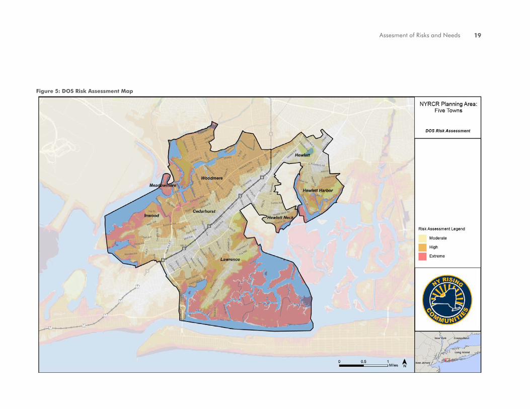
It is critical to understand the risk that the Planning Area’s assets could face in the event of future storms and sea level rise caused by climate change. To do this, New York State has developed a risk assessment area mapping tool (Figure 5) which defines areas at risk from coastal hazards in relation to their topography, Federal Emergency Management Agency (FEMA) flood zones, previous storm surge inundation, sea level rise, National Weather Service (NWS) shallow coastal flooding advisory thresholds, and natural shoreline features.
3.2 IDENTIFICATION OF ASSETS & RISKS
Critical assets in the Five Towns are grouped into six categories, Economic Resilience, Health & Social Services, Housing, Infrastructure Systems, Natural & Cultural Resources, and Socially Vulnerable Populations. Assets were identified through a series of exercises that involved community input, research, and analysis, including:
• Discussions at Planning Committee Meetings
• Feedback at Public Engagement Meetings
• Meetings in the local communities with committee members, local officials, and community members
• Site tours
• Data Analysis
The following presents a summary of the assets at risk within the Planning Area identified through the above assessment process.
Infrastructure
Natural & Cultural Resources
Socially Vulnerable Populations

New York Rising Community Reconstruction Conceptual Plan18
Extreme Risk Areas:
Areas currently at risk of frequent inundation, vulnerable to erosion in the next 40 years, or likely to be inundated in the future due to sea level rise. Extreme risk areas include:
• FEMA V zone
• Shallow Coastal Flooding per NOAA NWS’s advisory threshold.
• Natural protective feature areas susceptible to erosion.
• Sea level rise - Added 3 feet to the MHHW shoreline and extended this elevation inland to point of intersection with ground surface.
High Risk Areas:
Areas outside the Extreme Risk Area that are currently at infrequent risk of inundation or at future risk from sea level rise. High risk areas include:
• Area bounded by the 1% annual flood risk zone (FEMA V and A zones).
• Sea level rise - Added 3 feet to NOAA NWS coastal flooding advisory threshold and extended this elevation inland to point of intersection with ground surface.
Moderate Risk Areas:
Areas outside the Extreme and High Risk Areas but currently at moderate risk of inundation from infrequent events or at risk in the future from sea level rise. Moderate risk areas include:
• Area bounded by the 0.2% annual risk (500 year) flood zone, where available.
• Sea level rise - Added 3 feet to the Base Flood Elevation for the current 1% annual risk flood event and extended this elevation inland to point of intersection with ground surface.
• Area bounded by SLOSH category 3 hurricane inundation zone.
Assesment of Risks and Needs 19
Figure 5: DOS Risk Assessment Map

New York Rising Community Reconstruction Conceptual Plan20
3.2.1 Economic Development
Economic Development assets in the Five Towns include several commercial districts and corridors along Broadway in Woodmere/Hewlett and along Central Avenue in Cedarhurst and Lawrence (Figure 6). The commercial district along Rockaway Turnpike in Inwood was heavily flooded by Sandy’s storm surge, including the TD Bank and Costco. Inundation also extended up Rockaway Turnpike to the Five Towns Shopping Center near Meadowmere Park. Important economic assets in this area include the gas storage and distribution facilities in Inwood and Meadowmere Park. These facilities provide a large number of jobs and are located in low-lying areas that were inundated during Superstorm Sandy.
Several golf courses in the Five Towns were also identified by the community as economic assets. The Lawrence Country Club is a private course, but is publicly owned by the Village of Lawrence. The Inwood Country Club is also a private club, but is a large employer in the area. Both courses were inundated by storm surge during Superstorm Sandy and sustained significant damage.
While the retail spine of the Five Towns was on high ground, almost three quarters of the assessed value of commercial land (73.0%) is found in moderate, high and extreme risk
areas. The largest share, 42.4 percent is found in high risk areas, whereas 21.6 percent is found in Moderate risk areas and 9.0 percent in Extreme areas. Distributed among the communities that make up the Five Towns, Inwood, home to big box stores as well as warehousing facilities and a country club, has the highest share of commercial land use at 46.2 percent, almost all of which (99.5 %) is in Risk zones. This is followed by Woodmere at 17.2 percent (74.1 % in risk zones), Hewlett at 15.3 percent (47.3% in risk zones) and Cedarhurst at 15.0 percent (27.9% in risk zones).
Economic Development Examples
• Employment hubs and downtown centers
• Office buildings
• Industrial / warehousing
• Large retail stores
• Small businesses
• Banks
• Tourism destinations
Keystone Yacht Club
Cedarhurst Commercial District
Inwood Fuel Storage

Assesment of Risks and Needs 21
Figure 6: Economic Development Assets

New York Rising Community Reconstruction Conceptual Plan22
3.2.2 Health & Social Services
The Meadowmere Park Fire House served as a critical facility for shelter and recovery after Superstorm Sandy. Lawrence High School in Cedarhurst, which was closed for 6 months after Sandy due to mold and electrical damage from flooding, was also identified as a critical asset by the community. Also identified were Lawrence Junior High School, #2 School, #4 School and Middle School in the Village of Lawrence, as well as School #5 in the Village of Cedarhurst (Figure 7).
The Five Towns Community Center on Lawrence Avenue at Mott Avenue served as a critical distribution point and shelter for relief services after the storm. Publicly owned assets include village halls in Hewlett Neck, Hewlett Harbor, Lawrence, and Cedarhurst, which served as an impromptu command center. The only regional hospital in the Five Towns area is St. John’s Episcopal Hospital in Far Rockaway.
Health & Social Services Examples
• Schools
• Health care facilities
• Day care and elder care
• Government buildings
• Media and communications
• First responders such as police, fire and rescue
Meadowmere Park Fire House
DRS Yeshiva High School
Five Towns Community Center

Assesment of Risks and Needs 23
Figure 7: Health & Social Services Assets

New York Rising Community Reconstruction Conceptual Plan24
3.2.3 Housing
The Five Towns communities are primarily grouped around the Long Island Rail Road line that runs through the area (Figure 8). Clusters of multi-family properties are grouped around the five stops along the LIRR. These examples of transit oriented development present opportunities for low-risk housing, as many of these areas are located at high ground and out of the high and extreme risk zones.
The Five Towns as a whole are largely characterized by single-family residential, including many neighborhoods that are in extreme and high risk zones. These neighborhoods that are at risk of experiencing future flooding from extreme weather include Meadowmere Park, large sections of Woodmere, Cedarhurst, and Inwood, and sections of Lawrence, Hewlett, Hewlett Neck, and Hewlett Harbor.
Housing Examples
• Single-family residential neighborhoods
• Multi-family properties
• Senior housing
• Affordable housing
East Chateau Co-ops
Meadowmere Park
Pepperidge Road, Hewlett Harbor

Assesment of Risks and Needs 25
Figure 8: Housing Assets

New York Rising Community Reconstruction Conceptual Plan26
3.2.4 Infrastructure Systems
The stormwater system is consistently noted as the highest priority infrastructure asset, which is also most in need of repair, to restore the functionality of existing catch basins and outfalls, and determine needs for improvements. Cedarhurst has long planned to decommission the local sewage treatment plant; however it is currently handling capacity for the Bay Park Sewage Treatment Plant until the Bay Park facility is back at full capacity.
Key roadways include Peninsula Boulevard, Broadway, and Rockaway Turnpike. Transportation access was limited via Peninsula Boulevard, with congestion exacerbated by traffic from Queens attempting to get gas, and
few evacuation routes exist. The Long Island Rail Road is a key transportation infrastructure asset, with five stations within the community (Figure 9).
The electrical network in the Village of Hewlett Neck includes both underground wiring and overhead wiring; the underground network has been more problematic due to the impacts of flooding. Electricity infrastructure is owned by the Long Island Power Authority (LIPA). Four substations that serve Cedarhurst were flooded during Sandy. At the end of Doughty Boulevard, there are several liquid fuel distribution facilities. These facilities are low-lying, along the waterfront, and were flooded during Sandy.
Infrastructure Examples
• Transportation such as roadways and transit
• Stormwater
• Wastewater and water supply infrastructure
• Gas stations
• Solid waste or recycling
Meadowmere Park Footbridge
Dike at the Isle of Wight
Long Island Rail Road

Assesment of Risks and Needs 27
Figure 9: Infrastructure Assets

New York Rising Community Reconstruction Conceptual Plan28
3.2.5 Natural & Cultural Resources
The Five Towns are surrounded by water which provides critical habitat, including Hook Creek, Crooked Creek, Motts Creek, Bannister Bay, Hewlett Bay, Brosewere Bay, Bannister Bay, Grant Pond, and Willow Pond (Figure 10). Parks in the area that have been identified by the community as assets include Cedarhurst Park, Inwood Park, and a vacant parcel in Meadowmere Park that has formerly been maintained as a park by the Town of Hempstead.
Natural & Cultural Resources Examples
• Natural and ecological habitats
• Wetlands and marshes
• Parks
• Recreation and open space
• Museums
• Libraries
• Historic landmarks
• Religious establishments
Cedarhurst Park
Motts Basin, Inwood

Assesment of Risks and Needs 29
Figure 10: Natural & Cultural Resource Assets

New York Rising Community Reconstruction Conceptual Plan30
3.2.6 Socially Vulnerable Populations
As noted in the Community Profile, the Five Towns have a dramatic income gap and diverse communities. In part, this diversity also brings with it some populations that are at greater risk in the event of extreme weather, making it more difficult to evacuate to safety and to recover after the storm (Figure 11).
These socially vulnerable populations in the Five Towns include low-income communities in Inwood, which have a relatively high poverty rate and low household income. Mary’s Manor, also located in Inwood, cares for senior citizens. The Hebrew Academy for Special Children (HASC), located in Hewlett, is in the high risk zone. HASC provided supportive services to children with special needs, another population which is especially vulnerable during disasters.
In addition, there are affordable housing properties located in the high risk zone in Inwood - one of these properties is located at Lawrence Avenue and Randall Avenue, and the other at Bayview Avenue and St. George Place.
Socially Vulnerable Populations Examples
• People with disabilities
• Low-income populations
• The elderly
• Young children
• Homeless and people at risk of becoming homeless.Mary’s Manor
Hebrew Academy for Special Children

Assesment of Risks and Needs 31
Figure 11: Socially Vulnerable Population Assets

New York Rising Community Reconstruction Conceptual Plan32
3.3 NEEDS & OPPORTUNITIES
Though Sandy was an unprecedented event, the sources and causes of flooding observed on the greater scale during Sandy are regularly reflected on a smaller scale during high tides, rain storms, and nor’easters. Sandy has effectively exposed the greater system-wide inadequacy of flood mitigation and protection systems in the Five Towns, as well as the need for more robust comprehensive planning.
The objective of the needs and opportunities assessment is to evaluate potential for increased resilience in the short, medium, and long-term in the Five Towns. The following section presents an initial evaluation of the needs and opportunities within the Planning Area. These needs and opportunities will be refined through additional detailed analysis of the assets and risks within the Planning Area, as well as through input from the Planning Committee and public.
3.3.1 Community Planning & Capacity Building
NeedGreater coordination amongst community-based organizations that provide critical resources in educating residents in preparation of disasters and helping people recover.
OpportunityBuild upon strong network of community-based organizations, civic pride, and neighborhood identification to improve education and outreach.
3.3.2 Economic Development
NeedCoastal protections to prevent damage caused by flooding to employment centers and economic assets in low lying neighborhoods in Inwood and Woodmere; the area along Rockaway Turnpike at the junction with Nassau Expressway was identified as a critical commercial district needing additional protection.
OpportunityEnhance strong commercial corridors along Central Avenue (Lawrence and Cedarhurst) and Broadway (Woodmere and Hewlett) to provide additional services and employment opportunities for residents.

Assesment of Risks and Needs 33
3.3.3 Health & Social Services
NeedMedical facilities that are not in the flood zone and are accessible via transportation networks that are protected from flood risks.
OpportunityReestablish an outpatient medical facility in the Five Towns Community Center; Strengthen community connections to neighborhood organizations, religious organizations and local government in the incorporated villages.
3.3.4 Housing
NeedAddress aging housing stock and limited affordable housing, especially in high risk neighborhoods in Inwood.
OpportunityBuild upon strong sense of community amongst waterfront neighborhoods and community organizations that are involved with residents.
3.3.5 Infrastructure Systems
NeedStrengthened coastal protections, improved stormwater mitigation, expanded sewer networks and more reliable power grid and transportation infrastructure; Connections within the Planning Area, between the communities within the Five Towns and the rest of the region.
OpportunityEnhance resilience of grey and green infrastructure systems; Utilize large institutional facilities, municipal buildings, and open space to house microgrids and renewable energy.
3.3.6 Natural & Cultural Resources
NeedImprovements to wetlands that have been degraded and overdeveloped.
OpportunityRepair and expand wetlands that trap floodwaters, recharge groundwater supplies, remove pollution, and provide fish and wildlife habitat, and contribute to economic development because of their key role in fishing and recreation.

New York Rising Community Reconstruction Plan34

THE FIVE TOWNS
4.0 RECONSTRUCTION STRATEGIES

New York Rising Community Reconstruction Conceptual Plan36
4.1 OVERALL CONCEPT & KEY RECOVERY STRATEGIES
Based on input from the Planning Committee, feedback from Public Engagement events, and initial research, the following key concepts and reconstruction strategies represent a framework that will guide development and evaluation of potential projects.
The concept diagram in Figure 12 provides an overall framework for the reconstruction strategies and projects listed in this section. As can be seen by the two large corridors outlined, the concept plan looks to the preservation of high ground along the Long Island Rail Road and the enhancement of an evacuation route along the Nassau Expressway/Rockaway Turnpike Corridor. The first of these concepts is based upon the premise of keeping and enhancing key assets that are above the FEMA flood zones so that emergency supplies, evacuation centers, power supplies, and emergency management structures are pre-positioned out of danger and can act effectively in a storm. Many of these improvements can be accomplished in the near future.
The second concept is long term in that it requires a carefully developed plan for the Nassau Expressway/Rockaway Turnpike Corridor. These roads failed to serve as an
effective evacuation route during Superstorm Sandy because sections of Rockaway Turnpike flooded. These are also areas of intense peak hour traffic congestion at intersections such as Rockaway Turnpike and Peninsula Boulevard. Finally, two creeks, Hook Creek and Motts Creek, cross under Rockaway Turnpike just south of the Five Towns Shopping Center in Meadowmere. The tidal surge of Superstorm Sandy that flowed into these creeks was the primary cause of flooding in Cedarhurst, Woodmere, and South Valley Stream. If Rockaway Turnpike could be slightly elevated and flood gates installed where these two creeks intersect with the turnpike, then a flood barrier could eventually be created that could better protect upstream areas and important assets such as the Five Towns Shopping Center, Lawrence High School, and a significant number of residential neighborhoods.
Based on this framework, more detailed strategies and projects will evolve addressing the needs of and risk to the six asset categories. Potential projects will be assessed on their ability to mitigate future risk, vetted and prioritized by the Planning Committee and the public and categorized by their capacity to meet one or more of the following key strategies (Figure 13):
4.0 PRELIMINARY RECONSTRUCTION STRATEGIES

37Reconstruction Strategies
Strategy 1:
Increase the resilience to extreme weather in high risk coastal areas by addressing coastal protections and stormwater infrastructure.
Strategy 2:
Increase the emergency response capacity of facilities on high ground by building on the strong network of civic, health and social service organizations in the Five Towns.
Strategy 3:
Improve access from high risk areas to high ground and regional connections in order to strengthen evacuation routes and contribute to economic development along key corridors.
Figure 12: Concept Diagram

New York Rising Community Reconstruction Conceptual Plan38
4.2 POTENTIAL KEY PROJECTS
The following list of potential project examples represents a preliminary compilation of ideas that have come out of the NYRCR Planning process thus far. These project examples have been categorized around the three key strategies identified above. While these ideas represent projects suggested to date, additional projects will emerge as the planning process continues. Further, these projects will be evaluated by the Risk Assessment Scenario tool for their cost-benefit, evaluated by the Planning Committee and at Public Engagement meetings for support by the community, and tested for their ability to protect critical assets (Figure 14).
The potential projects are listed by community, however it should be noted that two projects - Lawrence High School and the Five Towns Community Center - are also listed as Shared Projects. In these two cases, the Planning Committee realizes that these projects would benefit all of the Five Towns and hopes that each community will contribute to their successful completion.
Figure 13: Key Reconstruction Strategies

39Reconstruction Strategies
Figure 14: Potential Key Projects

New York Rising Community Reconstruction Conceptual Plan40
Table 2: Potential Projects by CommunityCedarhurst: Potential Key Projects
Project Name Project Description Strategy
* Lawrence High School Evaluation of closing, relocation, or hardening;
Construct floodgates at Rockaway Turnpike or
levees to prevent flooding, or alternative
Strategy 1:
Increase Resilience
Cedarhurst DPW Facility Construct bulkhead to protect DPW facility from
flooding
Strategy 1:
Increase Resilience
Cedarhurst Village Hall Disaster
Response Plan
Capacity building for disaster response Strategy 2:
Increase Response Capacity
Rockaway Turnpike Floodgates Study flood protection options along Rockaway
Turnpike at Hook and Motts Creek, such as
moveable storm surge barriers to attenuate tidal
flow, and elevation of Rockaway Turnpike
Strategy 1:
Increase Resilience
Stormwater Infrastructure
Upgrades
Repair, upgrade, and maintain stormwater pipes,
drains, and catch basins
Strategy 1:
Increase Resilience
Hewlett: Potential Key ProjectsProject Name Project Description Strategy
Stormwater Infrastructure
Upgrades
Repair, upgrade, and maintain stormwater pipes,
drains, and catch basins
Strategy 1:
Increase Resilience
Hewlett Harbor: Potential Key ProjectsProject Name Project Description Strategy
Stormwater Infrastructure
Upgrades
Repair, upgrade, and maintain stormwater pipes,
drains, and catch basins
Strategy 1:
Increase Resilience
Pepperidge Road Stormwater
Upgrades
Stormwater upgrades and repaving to repair
damage from Sandy and prevent flooding
Strategy 3:
Improve Access
Seawane Drive Bridge Repair and fortify Seawane Drive Bridge Strategy 3:
Improve Access * See Five Towns Shared Projects

41Reconstruction Strategies
Table 2: Potential Projects by CommunityHewlett Neck: Potential Key Projects
Project Name Project Description Strategy
Stormwater Infrastructure
Upgrades
Repair, upgrade, and maintain stormwater pipes,
drains, and catch basins
Strategy 1:
Increase Resilience
Woodbine Ditch Improve stormwater capacity of Woodbine Ditch,
including green infrastructure
Strategy 1:
Increase Resilience
Street Light Infrastructure Protect underground wires that may be exposed Strategy 1:
Increase Resilience
Inwood: Potential Key ProjectsProject Name Project Description Strategy
Stormwater Infrastructure
Upgrades
Install check valves on outfalls at Bayswater Blvd;
Repair, upgrade, and maintain stormwater pipes,
drains, catch basins, and street end bulkhead
Strategy 1:
Increase Resilience
* Five Towns Community Center
Repairs and Disaster Response
Plan
Capacity building for disaster response;
Upgrade generator, showers, bathrooms,
laundry facility
Strategy 2:
Increase Response Capacity
Inwood Buccaneers Facility Repair damage caused by Sandy and increase
capacity for response to future disasters
Strategy 2:
Increase Response Capacity
Gas Storage Facilities Enhance existing flood levees Strategy 1:
Increase Resilience
Inwood Country Club Dike Repair existing dike to prevent flooding of
adjacent residential neighborhood
Strategy 1:
Increase Resilience
* See Five Towns Shared Projects

New York Rising Community Reconstruction Conceptual Plan42
Table 2: Potential Projects by CommunityLawrence: Potential Key Projects
Project Name Project Description Strategy
Meadow Lane Stormwater
Upgrades
Install catch basin pump system Strategy 3:
Improve Access
Dike at the Isle of Wight Repair breach in dike and increase height to
protect neighborhood from large storm surge
Strategy 1:
Increase Resilience
Meadowmere Park: Potential Key ProjectsProject Name Project Description Strategy
Meadowmere Park Community
Center
Build new community center to serve as a
recovery shelter during emergencies and a
day-to-day community resource
Strategy 2:
Increase Response Capacity
Footbridge Structural Assessment
and Repairs
Conduct structural assessment and make
necessary repairs
Strategy 3:
Improve Access
Bulkhead Replacement Program Bulkhead Replacement Program (assistance to
residents provided by Town of Hempstead)
Strategy 1:
Increase Resilience
Town of Hempstead-owned
Parkland Reconstruction
Repair bulkhead, reconstruct and reopen unused
parkland owned by the Town of Hempstead
Strategy 1:
Increase Resilience
Meadowmere Park Fire House Enhance flood protections and response capacity Strategy 2:
Increase Response Capacity
Woodmere: Potential Key ProjectsProject Name Project Description Strategy
Stormwater Infrastructure
Upgrades
Repair, upgrade, and maintain stormwater pipes,
drains, and catch basins
Strategy 1:
Increase Resilience

43Reconstruction Strategies
Table 2: Potential Projects by CommunityThe Five Towns: Shared Projects
Project Name Project Description Strategy
* Lawrence High School Evaluation of closing, relocation, or hardening;
Construct floodgates at Rockaway Turnpike or
levees to prevent flooding, or alternative
Strategy 1:
Increase Resilience
* Five Towns Community Center
Repairs and Disaster Response
Plan
Capacity building for disaster response;
Upgrade generator, showers, bathrooms,
laundry facility
Strategy 2:
Increase Response Capacity
Regional: Potential Key ProjectsProject Name Project Description Strategy
Rockaway Turnpike/Nassau
Expressway Upgrades
Study the potential to build floodgates at Motts
Creek and Hook Creek;
Elevate roadways to act as a levee;
Conduct traffic improvement measures to reduce
congestion
Strategy 3:
Improve Access
Microgrids Identify key locations on high ground for
microgrids and renewable energy to ensure
reliable communications during emergencies
Strategy 2:
Increase Response Capacity
Coordinated Mobile
Communications Unit
Create a coordinated operational response for
Nassau County Fire Departments
Strategy 2:
Increase Response Capacity
Stormwater Infrastructure
Upgrades
Repair, upgrade, and maintain stormwater pipes,
drains, and catch basins
Strategy 1:
Increase Resilience
Bulkhead Replacement Program Create public benefit district for bulkhead repairs Strategy 1:
Increase Resilience
New York Rising Community Reconstruction Conceptual Plan44
4.3 PRELIMINARY IMPLEMENTATION STRATEGIES
The NYRCR Plan requires careful consideration of what assets are at risk, what resources are available, and the capacity for mitigating risk through specific management measures. Selected management measures may include a variety of projects and actions, which would reduce the risk to a given asset, several assets or the community as a whole.
New York State has identified six classes of management measures that can reduce the exposure and vulnerability of assets to storm impacts. While some management measures have more immediate benefit to risk and resilience, others are more effective in combination with other strategies. These classes include:
• Class 1: Conserve, Restore, and Enhance Natural Protective Features
• Class 2: Resilient Construction
• Class 3: Structural Defenses
• Class 4: Land Use Planning and Regulation
• Class 5: Market-Based Methods
• Class 6: Increased Awareness and Information
As potential actions are developed, the Planning Committee will weigh the applicability of management measures according to the nature of the risk and immediacy of hazard, entities involved, and available resources. Projects will then be prioritized by their capacity to reduce immediate exposure to risk, serve multiple recovery functions, and support the larger recovery strategy. A preliminary overview of management measures for the projects listed above is shown in Table 3.

45Reconstruction Strategies
Table 3: Management MeasuresAction Class Responsible Agency Recovery Functions Timeframe
Lawrence High School 2, 3 Town of Hempstead; Village of Lawrence;
Lawrence Union Free School District
Infrastructure
Health & Social Services
Medium
Cedarhurst DPW Facility 2, 3 Village of Cedarhurst Infrastructure
Health & Social Services
Medium
Rockaway Turnpike Flood Gates 2, 3 USACE; Nassau County Infrastructure Long
Cedarhurst Village Hall Disaster Response Plan 6 Nassau County Office of Emergency
Management (OEM); Village of Cedarhurst
Community Planning & Capacity
Building
Short
Hewlett: Stormwater Infrastructure Upgrades 2 Nassau County; Town of Hempstead Infrastructure Medium
Hewlett Harbor: Stormwater Infrastructure
Upgrades
2 Nassau County; Village of Hewlett Harbor Infrastructure Medium
Pepperidge Road Stormwater Upgrades 2 Nassau County; Village of Hewlett Harbor Infrastructure Medium
Hewlett Neck: Stormwater Infrastructure
Upgrades
2 Nassau County; Village of Hewlett Neck Infrastructure Medium
Woodbine Ditch 1, 2 Nassau County; Village of Hewlett Neck Infrastructure Short
Inwood: Stormwater Infrastructure Upgrades 2 Nassau County; Town of Hempstead Infrastructure Medium
Five Towns Community Center Repairs and
Disaster Response Plan
6 Nassau County OEM; Village of Cedarhurst Health & Social Services
Community Planning & Capacity
Building
Short
Inwood Buccaneers Facility 2 Nassau County Community Planning & Capacity
Building
Short
Gas Storage Facilities 3 Economic Development
Infrastructure
Medium
Inwood Country Club Dike 2, 3 Town of Hempstead Economic Development
Infrastructure
Short
Meadow Lane Stormwater Upgrades 2 Village of Lawrence Infrastructure Short
Dike at the Isle of Wight 1, 3 Village of Lawrence; New York State Department
of Environmental Conservation (DEC)
Infrastructure Short

New York Rising Community Reconstruction Conceptual Plan46
Table 3: Management MeasuresAction Class Responsible Agency Recovery Functions Timeframe
Meadowmere Park Community Center 2, 6 Town of Hempstead Health & Social Services
Community Planning & Capacity
Building
Medium
Footbridge Structural Assessment and Repairs 2, 3 Town of Hempstead Infrastructure Short
Bulkhead Replacement Program 2, 3, 5 Nassau County; Town of Hempstead Infrastructure Long
Town of Hempstead-Owned Parkland
Reconstruction
1 Town of Hempstead Natural & Cultural Resources Short
Meadowmere Park Fire House 2, 6 Nassau County; Town of Hempstead Health & Social Services Short
Woodmere: Stormwater Infrastructure Upgrades 2 Nassau County; Town of Hempstead Infrastructure Medium
Rockaway Turnpike/Nassau Expressway
Upgrades
2, 3, 4 New York State Department of Transportation
(DOT); NYS DEC; Nassau County; Town of
Hempstead
Infrastructure Long
Microgrids 2, 6 Nassau County; Town of Hempstead Infrastructure Short
4.4 REGIONAL PERSPECTIVE
The Five Towns are located in south western Long Island, adjacent to New York City and protected from the Atlantic Ocean by the barrier islands of Atlantic Beach and Long Beach. As a result, multiple regional projects that impact the Jamaica Bay and other waterways around the Five Towns need to be evaluated and assessed to ensure that the Five Towns NYRCR Plan is not duplicating or conflicting with other efforts.
The most significant current and proposed projects which will impact the proposed
reconstruction strategies developed through the NYRCR planning process include New York City’s proposed flood gates at Marine Parkway in Jamaica Bay and the U.S. Army Corps of Engineers construction of sand dunes, boardwalks, and/or seawalls in Far Rockaway and on Long Beach Island (Figure 15). In addition, the City of Long Beach bulkhead repair and construction project presents an important precedent as a model of municipal management of bulkheading of private property. JFK Airport is another key regional asset and stakeholder that will be impacted by the construction of floodgates in Jamaica
Bay and improvements of coastal protections on the Rockaway Peninsula and Long Beach Island.
An additional challenge will be coordination amongst multiple overlapping jurisdictions within Nassau County, including the various villages within the Five Towns, the Town of Hempstead, which administers multiple unincorporated communities within the Five Towns, and Nassau County, which controls some infrastructure including county roads. Therefore, it is critical that the NYRCR process is inclusive of community, city, state, and federal

47Reconstruction Strategies
agencies who share jurisdictional control and responsibility in the Five Towns.
One critical component of this coordination will be determining jurisdictional responsibility on priority projects identified by the committee. To date, some projects have been discussed as priorities for certain communities, but that represent repairs or upgrades that were needed in advance of Superstorm Sandy. In these cases, the Planning Committee may determine that some projects should remain the responsibility of the local jurisdiction, rather than the committee allocating scarce resources to projects that should be undertaken by a village in the Planning Area, the Town of Hempstead, or Nassau County.
Reconstruction strategies will be evaluated by the Planning Committee on a regional basis, rather than in a vacuum, considering current or proposed projects as well as parallel planning efforts such as Long Term Community Recovery (LTCR) plans. As all NYRCR Planning Committees work through the planning process, collaboration with other committees on Long Island and in New York City will lead to coordinated reconstruction strategies that can serve multiple recovery functions. The State will continue to facilitate communication among organizations, by sponsoring meetings and workshops to address regional challenges
and craft comprehensive strategies for building both a more resilient Five Towns, and a stronger New York State.
Figure 15: Regional Map

New York Rising Community Reconstruction Plan48

THE FIVE TOWNS
5.0 PUBLIC ENGAGEMENT

New York Rising Community Reconstruction Conceptual Plan50
The community engagement process for the Five Towns has been structured to encourage a broad segment of the diverse communities of the area to provide input and participate in the process of developing a NYRCR Plan that envisions a more resilient and sustainable future built upon a solid base of public support.
The Five Towns Planning Committee has broad representation from the eight communities within the Planning Area. The Planning Committee is composed of 14 members from neighborhoods across the planning area, including residents, civic leaders, local business and community organization representatives, and other key stakeholders. The Planning Committee has been instrumental in providing input and information to shape this Conceptual
Plan and in assisting with the broader Community Engagement Strategy through their constituent and social networks. The Planning Committee has worked to implement a strategy that lowers barriers to participation and has included the participation of a significant number of stakeholders including a representative cross section of the greater public.
The public has been involved in the development of the Conceptual Plan through two primary forums: Planning Committee meetings and Public Open House Workshops.
Planning Committee Meetings
To date, the Community Engagement Strategy
5.0 PUBLIC ENGAGEMENT

Public Engagement 51
has included three Planning Committee meetings focused on the development of this Conceptual Plan. Planning Committee meetings have occurred on September 12, October 3, and October 24. These meetings, and all future Planning Committee meetings, are open to the public and details are posted on the NYRCR program’s website: http://stormrecovery.ny.gov/community-reconstruction-program.
The first Planning Committee meeting occurred on September 12, 2013 and included a presentation of the NYRCR Program in order to orient that committee on the process of creating the NYRCR Plan.
The second Planning Committee meeting, which occurred on October 3, 2013, included a
presentation and discussion of what happened during Superstorm Sandy, the Planning Area’s asset inventory, ideas for a vision statement for the Five Towns, and the projects that have been proposed by the Planning Committee.
The third Planning Committee (October 24, 2013) meeting focused on a review of the Draft Conceptual Plan.
These meetings have been supplemented with additional meetings of the co-chairs, assorted committee members, local elected officials, and engineers from the villages and the Town of Hempstead. These local meetings were useful in identifying specific issues within the varied geography of the Five Towns.
Public Open House Workshops
The first Public Open House Workshop was held on October 17, 2013. This meeting focused on gathering the public’s knowledge, experience, and recommendations for the development of the Conceptual Plan. The public was invited to provide input on the Planning Committee’s work to date, including its work on the Community Vision, Identification of Community Assets, and Potential Projects.
The Public Open House Workshop was advertised through the Planning Committee’s vast network of contacts. Advertising flyers were produced in English and Spanish. Approximately 50 community members attended the event.
The Public Open House Workshop began with a brief overview presentation. Attendees were then guided through four stations. Throughout the stations, the public had the opportunity to talk with Committee members, a State Planner, NYRCR staff and Consultant Team, as well as provide written comments in several ways. The stations were organized as follows:
Station 1: Background/Process:
Participants were invited to speak with a Department of State Planner for background on the overall program, as well as to view

New York Rising Community Reconstruction Conceptual Plan52
several boards with information on the planning process that supports the program.
Station 2: Community Vision:
First participants were asked four vision-related questions and asked to post their responses on an easel pad.
Station 3: Community Assets:
Participants were asked to view the Community Assets identified to date, which were displayed on maps with shading to represent risk areas. The public was asked to add additional assets,
provide comments directly on the maps using markers, and respond to asset category-related questions.
Station 4: Potential Projects:
Participants were asked to view a list and a map that included existing and proposed projects identified by the Committee and Project Team. Participants were then asked to brainstorm additional project ideas and endorse preferred projects by placing a dot or note next to that item on the presentation board.
Conceptual Plan Development
The content of the Conceptual Plan has been generated and vetted by the public in the fashion described above to ensure a Plan that features projects, policies and actions with broad community support.

Public Engagement 53

New York Rising Community Reconstruction Plan54

THE FIVE TOWNS
6.0 IMPLEMENTATION STRUCTURE

New York Rising Community Reconstruction Conceptual Plan56
The community will identify key projects and reconstruction strategies in the categories of community planning and capacity building, economic, health and social services, housing, infrastructure, and natural and cultural resources. These projects will then be evaluated further based on several factors including time range (immediate/intermediate, long-range), geographic scope (regional or local), financial cost, and benefits (public versus private interests).
Assessing the benefits and costs of the project is imperative to determine if the project is feasible and implementable. Once the costs and benefits have been determined and the project is deemed feasible, timeline, funding source and responsible agency will be identified.
Determining Benefits
The benefits of a reconstruction project will focus on hazard risk reduction and increasing public safety. The risk reduction estimate (or hazard loss avoidance) may be determined through use of the New York State Risk Assessment Tool or the Hydrologic Engineering Centers River Analysis System (HEC-RAS) model, dependent on available data and nature of the project. Additional benefits (co-benefits) to a project may include sustainability, economic benefits, environmental benefits and health and social
benefits. Examples include the number of potential lives saved and expected economic gains, such as community revitalization.
Determining Costs
Project costs will be based off the scope of work and include management, construction cost (including administration and management), life cycle costs (annual maintenance), useful life (number of years before the project will need to be replaced). Costs should also consider the socio-economic impacts such as displacement of population.
Timeframe
Immedia te/ In te rmedia te/Long-Range Implementation – an action that could reasonably be implemented in two (2) years or less would be an Immediate action; within two to five (2-5) years would be Intermediate; and an action that would take longer than five (5) years to enact would be Long-Range.
Funding Sources
The final projects presented in the NYRCR Plan are not limited to the CDBG-DR funds ($27.6 million). Additional funding sources may be utilized and include:
• FEMA Funding (pre-disaster, post-disaster)
• HMA Program: post-disaster (HMGP) and
6.0 PRELIMINARY IMPLEMENTATION STRUCTURE

Implementation Structure 57
pre-disaster(PDM, FMA)
• Other Federal Agencies (USACE, EPA)
• Public-private partnerships
• Local Funding including taxation and Bonds
Responsible Agency
Lastly, a responsible agency will be identified for each project. The responsible agency will be determined based on the nature of the project.
Eligible Activities HMGP PDM FMA
1. Mitigation Projects X X X
Property Acquisition and Structure Demolition X X X
Property Acquisition and Structure Relocation X X X
Structure Elevation X X X
Mitigation Reconstruction X
Dry Floodproofing of Historic Residential Structures X X X
Dry Floodproofing of Non-residential Structures X X X
Minor Localized Flood Reduction Projects X X X
Structural Retrofitting of Existing Buildings X X
Non-structural Retrofitting of Existing Buildings and Facilities X X X
Safe Room Construction X X
Wind Retrofit for One- and Two-Family Residences X X
Infrastructure Retrofit X X X
Soil Stabilization X X X
Wildfire Mitigation X X
Post-Disaster Code Enforcement X
Generators X X
5 Percent Initiative Projects X
Advance Assistance X
2. Hazard Mitigation Planning X X X
3. Management Costs X X X
Source: FEMA

New York Rising Community Reconstruction Plan58

THE FIVE TOWNS
7.0 APPENDIX

New York Rising Community Reconstruction Conceptual Plan60
There are a diversity of plans, policies, procedures and resources available that address the existing conditions, regulatory frameworks, community goals and issues and resiliency opportunities in the Five Towns. These resources have been produced by a variety of stakeholders including public agencies at all levels (federal, state, county, town and village), regional planning groups, non-profit organizations, academic institutions, community stakeholders and private groups. A brief summary of the relevant regulatory and advisory documents is included below:
Regulatory
Federally approved Significant Coastal Fish and Wildlife Habitats (New York State Department of State [NYSDOS], New York State Department of Environmental Conservation [NYSDEC])
East Hempstead Bay, the water body to the south east of the Five Towns, is designated as a Significant Coastal Fish & Wildlife Habitat (SCFWH). For each designated SCFWH site, a habitat map and narrative are created to provide site-specific information. The habitat narrative constitutes a record of the basis for the significant coastal fish and wildlife habitat’s designation and provides specific information regarding the fish and wildlife resources that depend on this area. General information is also provided to assist in evaluating impacts of proposed activities on characteristics of the habitat which are essential to the habitat’s values.
Long Island South Shore Estuary Reserve - Comprehensive Plan (NYSDOS, 2001)
The Long Island South Shore Estuary Reserve encompasses one of the New York State’s unique estuaries and its 326 square mile watershed in Nassau and Suffolk counties. The plan provides a blueprint for the long-term health of the Reserve’s bays and tributaries, its
7.0 APPENDIX A

Appendix 61
tidal wetlands and wildlife, and its tourism and economy.
Nassau County Department of Public Works Drainage Requirements (Nassau County Department of Public Works, 2004)
The Phase II Storm Water Regulations requires all municipalities in Nassau County to prepare and implement a Storm Water Management Program. A major component of the County’s Storm Water Management Program is the drainage requirements set by the Department of Public Works for the development of Subdivisions. This comprehensive document includes the drainage requirements for street grading and drainage and the requirements for erosion and sediment control.
Nassau County Stormwater Management Program Plan (Nassau County, 2009)
The NCSWMP includes a listing of Best Management Practices (BMPs) that have been implemented by the County and a coalition of local municipalities in order to achieve the regulatory standard of reducing pollutants in the County’s storm water to the maximum extent practicable. Initial measurable goals and an implementation schedule were developed for each of the BMPs in the NCSWMP.
Town of Hempstead Adopted 2013 Budget (Town of Hempstead, 2013)
Town of Hempstead’s 2013 spending plan for municipal programs and services. Hempstead maintains 1,200 miles of roadway, operates over 200 parks, pools, beaches and marinas, collects garbage from 85,000 homes, provides water to 130,000 customers and furnishes life enhancing services to over 190,000 senior citizens. At $419.4 million, this 2013 budget proposal presents a modest positive adjustment of 1.1 percent or $4.6 million over the 2012 figure.
Advisory
Hurricane Sandy Rebuilding Strategy (U.S., Hurricane Sandy Rebuilding Task Force, 2012)
The Rebuilding Strategy document developed by the task force establishes guidelines for the investment of the Federal funds made available for recovery. The document focuses on long-term rebuilding, and strategies to sponsor coordination amongst various agencies to remove obstacles to resilient rebuilding.
Nassau County Draft Master Plan (Nassau County, 2010)
Master Plan recommends targeting development in growth areas, which account for approximately 10% of Nassau’s land area. Specifically identified growth areas include “Transit-Oriented” downtowns, the Nassau Hub, and the Grumman Property. The Master Plan details changes in demographic and economic conditions for past decades and projects future changes through 2030. In addition, the Master Plan identifies specific policy tools to encourage growth, diversify the housing stock, protect commercial and residential neighborhoods, improve transportation, and reduce costs to residents.

New York Rising Community Reconstruction Conceptual Plan62
Nassau County Multi-Jurisdictional Hazard Mitigation Plan (Nassau County, 2007)
Description of various hazards, identification of assets in hazard areas, estimated damages in assessment areas (includes assets exposed to storm surge), development trends in hazard areas and capabilities and resources. Asset information and community specific recommendations are developed for some communities however this information is sparse for the Five Towns. Implementation strategies and mitigation measures can be learnt from recommendations for neighboring communities. Document lists federal technical assistance and funding programs to assist in long-term recovery.
Long Island Regional Economic Development Council Strategic Plan (LIREDC, 2011)
Long term economic development strategy discusses 13 priority projects. Infrastructure strategies include: Revitalize downtowns and commercial centers; Repair and upgrade aging infrastructure; Create new housing opportunities; Promote new government policies to foster economic growth. Natural Asset Strategies include: Improve sustainable agriculture enterprises; Improve the Economic Potential and Employment Opportunities of Fisheries & Aquaculture; Enhance Ecotourism Activities and Infrastructure.
Cleaner Greener Long Island (CGCLI, 2013)
Cleaner Greener Consortium of Long Island is group of municipalities and non-governmental organizations organized to articulate a community based vision for a more sustainable future. Goals and strategies were developed for the following subject areas: Economic development and workforce housing; energy; transportation; land use and livable communities, waste management; water management; governance and implementation. The Plan is intended to serve as a common point of reference for local governments, non-governmental organizations, businesses and residents. It includes initiatives for implementation, objectives and performance targets, as well as a wealth of baseline information (in the appendices) that can be incorporated into comprehensive plans, management plans, zoning, and other planning and strategy initiatives.
The Long Island Index: “Places to Grow” (Regional Plan Association, 2010)
Report analyzed the future growth potential for Long Island, focusing on the Island’s ability to accommodate forecasted residential and commercial growth in transit-rich downtowns through an analysis of infrastructure capacity, land use, and demographic data. The report
found that nearly 8,300 acres of vacant land and parking lots lie within a ½ mile radius of downtown centers (or LIRR stations). Report supports targeting future growth to downtowns given the host of environmental, social, and economic advantages. In addition, the report cites the downtown revitalization efforts of the Village of Mineola which adopted overlay zoning district to attract and incentivize transit-oriented development.
Long Island Infrastructure Priorities to Recover from Hurricane Sandy (Long Island Association, 2012)
This list represents the work of several leading organizations on Long Island. Priorities are listed in the following order: (1) Public Health: Wastewater Treatment Facilities, Water Supply and Solid Waste; (2) Utilities: Electric, Gas and Telecommunications; (3) Transportation, Transit and Shoreline; (4) Housing.
Priorities related to infrastructure were at the top of the list because of the significant public health and economic development impacts of wastewater treatment facilities, water supply and solid waste. These priorities are also responsive to the charge given to the Infrastructure Working Group of Governor Cuomo’s Long Island Regional Economic Development Council.

Appendix 63
Nassau County 2013 Annual MS4 Report (Nassau County Stormwater Coalition, 2013)
The Nassau County Stormwater Management Program (NCSWMP) is a comprehensive program to reduce the levels of contaminants in Nassau County’s storm water runoff and educate the public about their impacts on storm water. Nassau County has taken the lead in coordinating the NCSWMP and acting as a clearinghouse of information for concerned parties. The Nassau County Department of Public Works Water Engineering Unit is in charge of implementing the plan, including water testing, education, and pollution prevention measures. The six elements of the NCSWMP are: Public Education, Public Involvement, Illicit Discharge Detection and Elimination, Construction Site Storm Water Runoff Control and Post-Construction Storm Water Management, Pollution Prevention and Good Housekeeping for Municipal Operations.
Nassau Urban County Consortium 5 Year Consolidated Plan (Nassau County, 2010)
Presents a five-year strategy for addressing housing and community revitalization needs within the 34 member Urban County Consortium. It includes a One Year Action Plan for spending approximately $21,524,865 in Community Development Block Grant, HOME, Emergency Shelter Grant and program income
funds. Funds will be spent on a wide range of housing and community development activities including new construction and rehabilitation of housing; commercial and economic improvements; public services for senior, youths and low income persons; architectural barrier removal in private homes and in public buildings; homeless shelter operations and renovation; acquisition, demolition and relocation activities of blighted properties in targeted redevelopment areas; infrastructure improvements in low income areas; and other related activities. Inwood, one of the Five Towns communities, is listed as one of the revitalization areas where activities will be carried out.
Nassau County Infill Redevelopment Feasibility Study: Cultivating Opportunities for Sustainable Development (Nassau County, Regional Plan Association, and NY-CT Sustainable Communities Consortium, 2013)
Feasibility study of sustainable infill development and presents opportunities to promote transit-orientated development around up to three (3) Long Island Rail Road (LIRR) stations in the Preliminary Regional Nassau Hub Study Area. Closest LIRR stations in study are Rockville Centre and Baldwin.
Long Island 2035 Sustainability Plan and Visioning Initiative (LIRPC/Nassau County/Suffolk County/NYMTC/RPA, 2009)
Established to help achieve a regional public consensus on where the next generation of Long Islanders could live and work, the transportation systems needed to support these settlements and the public and private actions required to ensure a prosperous, equitable and environmentally sustainable Long Island.
Long Island 2035 Comprehensive Sustainability Plan (Nassau County/Suffolk County/LIREDC/LI2035, 2010)
Involved stakeholder input from Leadership Advisory Cabinet (LAC), made up of key government officials and private sector stakeholders. LAC tested and vetted strengths, weaknesses, issues and opportunities facing region and identified a vision, goals and objectives for the Long Island 2035 Regional Comprehensive Sustainability Plan. The plan is focused into four general areas: Economy, Infrastructure, Human Systems, and the Built and Natural Environments.