the duboka piracy
TRANSCRIPT
GEOGRAPHICAL INSTITUTE “JOVAN CVIJIC” SASA COLLECTION OF PAPERS NO 58 YEAR 2008
911.2:551.4 (497.11) Predrag Djurović*, Ljubomir Menković**
THE DUBOKA PIRACY Abstract: The Duboka drains the eastern side of Kopaonik Mountain. Geomorphology and geology of the area indicate, and the office and field researches confirm, that the Duboka was formerly in the Rasina basin and now belongs to the Toplica system. A minor Toplica tributary captured the Duboka headwater and diverted it into its drainage system. Capturing and captured s of the two systems are a geomorphologic rarity; the headwaters of the Rasina are diverted into the Toplica system, and the middle course of the Toplica (Blatašnica) captures the Rasina. Key words: piracy, Kopaonik, Duboka, Rasina, Toplica, Serbia.
Introduction
Piracy is an uncommon feature in the topography of this country. Each new discovery of an unexplored piracy is a contribution to the study of the origin and evolution of the fluvial land configuration. Piracy has been studied from the beginning of the morphology. The Blatašnica capture diverted a part of the Toplica system through the Jankova Canyon into the Rasina basin (Cvijić, 1909). A similar example was noted while prospecting the confluence of the Raška-Kraljevo (northern) and Kosovska Mitrovica (southern) valleys in the Ibar basin, caused by the Tvrđen capture (Cvijić, 1926). The Strem tributary of the Marica, Bulgaria, captured in the late Pliocene a Balkan foothill. The Tundža, another Marica tributary, captured in the early Pleistocene the middle course of the Balkan foothill (Cvijić, 1908, 1926). Channels connecting the valley systems of the Pannonian and Aegean basins in the southern course of the Morava indicated the likely piracy (Jovanović, 1938). Its evidence was found where the Moravica cut its gorge at the exit from the Kumanovo-Skopje basin and deviated to the Vranje basin (Milojević, 1951). Piracy controlled the gradual diversion of rivers heading to the Aegean Sea into the rivers of the Pannonian drainage area by shifting the watershed from Grdelica Canyon, across Vranje area, to the Preševo-Kumanovo divide (Milić, 1967). River piracy usually manifests in certain topographic 'anomalies', primarily the elbow of capture and partial inversions of landforms, 'fossil' saddle and allogenic * Geographical Faculty, Belgrade, [email protected] ** ex Geographical institute Jovan Cvijic SASA, Belgrade

Predrag Djurović, Ljubomir Menković GIJC SASA
18
gravelly material. In the case of eastern Svrljig basin, the accumulation of allogenic gravel is as thick as ten metres, deposited by the Stara Planina River before the capture of its headwaters by the Trgoviški Timok in the late Upper Pliocene (Dinić, 1967). Neotectonic processes may cause a total inversion of relief, whereas partial inversion in a river basin may be the result of a river capture (Zeremski, 1980). Every example of river piracy has a different history in the evolution of the regional land configuration. It is a common understanding that piracy is the capture of a weaker river in one drainage area by a stronger river in another basin. Some researchers indicate that a river may cut its new channel in the watershed and capture a river from another drainage area as a consequence of the geological setting and structure, tectonic event (Lazarević, 1994), character of the initial relief, relationship to the base level of erosion, neotectonic movements (Zeremski, 1980), or regressive erosion (Davidović, 1984). Other controls of piracy mentioned in the references are different heights of the base levels of erosion, but also different precipitation depths in adjacent basins, which has not the bearing but is one from the group of possible causes (Gavrilović, Stanković, 1966). Regional or local tectonic events cause a change in the base level of rivers, which leads to greater regression that tends to establish new curves in river-channel slopes. The down cutting valley, increasing slope and strong river erosion are in contrast with less intense fluvial processes in adjacent basins. Rejuvenated river erosion enhances soil erosion and, according to some piracy researchers, may lead to rapid soil erosion and consequent adverse economic effects. Rapid soil erosion in the Jankova Gorge area and frequently torrential flow of the Blatašnica, like in the Grdelica Canyon, are explained by recent piracy, along with the geology and scarce vegetation (Milić, 1968). A control of the piracy mentioned is the change in climate during the Pleistocene. An explanation for the contemporary piracy of the Uvac, Ibar and a Pliocene river in Balkan foothills of Bulgaria (Cvijić, 1926) is climate fluctuation during the Pleistocene; the piracies of all three rivers occurred roughly at the same latitude and in mountainous regions of Balkan Peninsula (Zeremski, 1962). The elbow of capture diversions, or piracy, may result from deep fault-lines and horizontal displacement of the fault blocks (Gavrilović, 1983). Neotectonic movements also resulted in an underground river capture, which caused rerouting of karst groundwater flow and partial beheading of sinking rivers (Zeremski, 1983).

COLLECTION OF PAPERS NO 58 (2008) The Duboka Piracy
19
The conclusion based on the brief review of the piracy research in this and the bordering countries is that two basic factors of river piracy are tectonic events (active faults and neotectonic movements) and climate change in the Quaternary.
Figure 1. Geographical location of the Duboka River
Predrag Djurović, Ljubomir Menković GIJC SASA
20
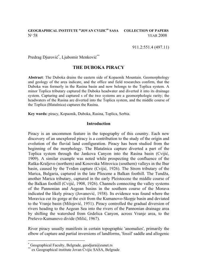
The Duboka River Basin and Its Physical Geography Piracy of the Duboka River was observed only recently to the east of the generally well studied Kopaonik Mountain. Students of the Second Geomorphologic School collected the basic information presented in this paper from during field trips on Kopaonik. In the Brzećka reka valley, at the village of Brzeće, the path turns into a wide, relatively shallow valley some 5 km long. A barely discernible channel of an intermittent weak river runs down the valley. Neither the valley nor the river has local names. For convenience of the geographic reference, they are provisionally named the Junior valley and river after a hotel in the valley (Fig. 1). Headwaters of the Duboka are on Kopaonik, about 2000 m above the sea level. The source area is under the influence of the current periglacial processes. Lower in the river basin, fluvial denudation is the dominant process, while karstification evolves on minor limestone outcrops.
Geology
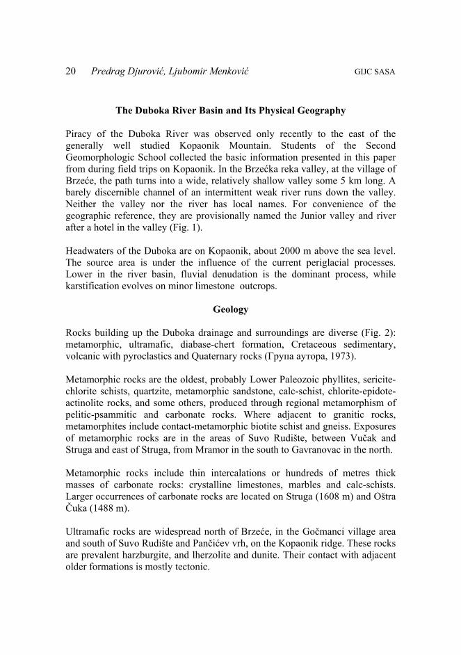
Rocks building up the Duboka drainage and surroundings are diverse (Fig. 2): metamorphic, ultramafic, diabase-chert formation, Cretaceous sedimentary, volcanic with pyroclastics and Quaternary rocks (Група аутора, 1973). Metamorphic rocks are the oldest, probably Lower Paleozoic phyllites, sericite-chlorite schists, quartzite, metamorphic sandstone, calc-schist, chlorite-epidote-actinolite rocks, and some others, produced through regional metamorphism of pelitic-psammitic and carbonate rocks. Where adjacent to granitic rocks, metamorphites include contact-metamorphic biotite schist and gneiss. Exposures of metamorphic rocks are in the areas of Suvo Rudište, between Vučak and Struga and east of Struga, from Mramor in the south to Gavranovac in the north. Metamorphic rocks include thin intercalations or hundreds of metres thick masses of carbonate rocks: crystalline limestones, marbles and calc-schists. Larger occurrences of carbonate rocks are located on Struga (1608 m) and Oštra Čuka (1488 m). Ultramafic rocks are widespread north of Brzeće, in the Gočmanci village area and south of Suvo Rudište and Pančićev vrh, on the Kopaonik ridge. These rocks are prevalent harzburgite, and lherzolite and dunite. Their contact with adjacent older formations is mostly tectonic.
COLLECTION OF PAPERS NO 58 (2008) The Duboka Piracy
21
Figure 2. Geological map: 1. Coarse-clastic fluvial sediments; 2. Granitoid; 3. Dacite andesite;
4. Pyroclastics; 5. Massive Upper Cretaceous limestones; 6. Upper Cretaceous flysch and basal conglomerate and breccia; 7. Diabase-chert formation; 8. Ultramafic rocks; 9. Crystalline limestone, marble and calc-schist;
10. Metamorphic rocks; 11. Fault; 12. River piracy area. The diabase-chert formation, commonly in ultramafic rocks, is located north of Brzeće, left side of the Brzećka River. The formation consists of magmatic and sedimentary rocks. Magmatic rocks are gabbroid varieties, diabase and gabbro diabase. Sedimentary rocks are sandstone, mudstone, clay slate, subordinately breccia and conglomerate. Chert is sporadic through the formation, and there are local occurrences of limestone slabs. Jurassic age of the rocks is determined using the contained fossil macro and mega fauna.

Predrag Djurović, Ljubomir Menković GIJC SASA
22
Cretaceous rocks form eastern ridges of Kopaonik, east of Vojetin, Mramor and Brzeće. These are clastics prevalent over massive reef limestones. The clastics consist of conglomerates and conglomerate breccia at the base of Upper Cretaceous, and far more flysch widespread. Massive reef limestones have a smaller coverage, only on Vojetin, where they are transgressive over Paleozoic metamorphic rocks. Brecciated at the base, limestones grade upward into white, locally marbleized, limestones. The fossil content indicated Senonian age of all Cretaceous sedimentary rocks. Volcanic rocks, exposed south of Ravništa village, are represented dominantly by dacite-andesite and subordinately quartz latite and basaltoids. These rocks, always associated with pyroclastics, build up Vojetin (1561 m), Koritsko Brdo (1398 m) and Belićka Čuka (1139 m). Granitoid rocks – granodiorite, quartz monzonite and quartz diorite – form central Kopaonik north of Suvo Rudište, impressed into the Paleozoic core of the Kopaonik-Željin anticlinorium during the lowermost Miocene. Quaternary rocks of different genetic types. Slope-wash materials cover hill and mountainsides. Most interesting are fluvial coarse clastics observed near the Mramor hamlet on a saddle, height 1127 m, about 200 m above the present-day Duboka channel. Fluvial deposits on the saddle near Mramor and downriver of it, along the Junior valley, consist of rounded clasts and pebbles of various sizes, from a few centimeters to several decimeters in diameter. Petrologic composition includes varied rocks, pebbles of gneiss, granodiorite, quartz schist, quartzite, and so on, clasts of all rocks building up the Duboka catchment upriver of Mramor. Kopaonik as a whole belongs to the Vardar Zone tectonic unit, extending in the general direction NW-SE. Geological formations and regional faults have the same direction. Main fault of NW-SE strike direction runs from Jaram controlling the Duboka valley to Đerekare. Volcanic rocks around Đerekare and most likely the seismic activity in Kopaonik region are related to this fault.
The Duboka River Piracy
The Duboka is one of many rivers that cut their valley into the country rock of Kopaonik. Its valley is deep between 200 m and 300 m. The river source area is immediately below Suvo Rudište, surrounded by the highest peaks and ridges of Kopaonik: Suvo Rudište (1900 m), Pančićev vrh (2016 m) and Karaman

COLLECTION OF PAPERS NO 58 (2008) The Duboka Piracy
23
(1904 m) on the west, Ledenice and Struga (1608 m) on the north and Bedjirovac (1782 m) on the south. Headwaters of the Duboka run norheastward to the altitude of around 1300 m, and then the river deviates to SE. Downriver of Đerekare the river changes the name into the Đerekarska reka and flows into the Toplica near Blaževo. Field observations indicate that the Duboka formerly drained into the Brzaćka reka , a right tributary of the Rasina. Its former channel crosses the present-day Mramor saddle, traversed the Junior valley to its confluence with the Brzeća. The river valley south of Mramor, and the saddle itself, are the abandoned Duboka channel. Evidences leading to this conclusion are the following:
− The abandoned Duboka valley (Junior valley) is now much wider, kilometric in size and between 200 m and 300 m deep. The nameless river in it, now referred to as the Junior brook, is very weak. It could not have been much stronger in the past to develop such a wide valley; a stronger and bigger river must have done it.
− Coarse clastic fluvial sediments of cm-dm size rounded clasts and pebbles lie deposited on Mramor saddle. Petrologic composition of fluvial sediments includes clasts of diverse rocks (granitoids, quartzite, quartz schist, chlorite-epidote schist) with prevalent granitoid pebbles. The Junior valley downriver of the Mramor saddle contains fluvial sediments of similar rocks. Granitoid rocks have not been found in the Junior catchment, but are located in the upper reaches of the Duboka. This implies that the fluvial sediments are not autochthonous, not deposited by the Junior River, but allochthonous constituents deposited in another, adjacent, Duboka catchment.
− The Junior valley has not a riverhead, which is missing. Its valley broadens to the Duboka valley as if cut short by the latter. Junior valley runs from Mramor Saddle 1127 m high as a well-developed valley floor and high valley sides. Its upper end looks 'perched' over the Duboka River, around 200 m above its present-day channel.
− Knowing the petrologic and granulometric compositions of the fluvial sediments, and their position on the very saddle and downriver of it, it has been inferred that the sediments were not transported by the Junior, but by a bigger and stronger river, most likely the Duboka.
The above evidences lead to the conclusion that the Duboka flew to the Brzećka, which, under the name of the Graševačka River joined the Rasina, and captured diverted to the Toplica system. The pirate river was the Đerekarska River, now the downriver course of the Duboka. The Duboka headwater was captured at the level of Mramor saddle (1127 m), where its channel was before the piracy.

Predrag Djurović, Ljubomir Menković GIJC SASA
24
The Đerekarska River eroded its head backwards through the watershed range into the adjacent Duboka basin. Because the Đerekare channel was lower than the Duboka channel, it diverted the upper course of the Duboka with all tributaries into its drainage system. In doing so, drainage of an area of around 20 km2 transferred from the Rasina to the Toplica basin (Fig. 3).
Figure 3. Sketch figure of the Duboka piracy: 1. Capture area; 2. The Duboka
drainage area transposed from the Rasina into the Toplica basin; 3. Recent watershed; 4. Old watershed line between the Rasina and the Toplica.
Upon the capture of the Duboka headwaters, the Đerekarska River increased its discharge, its potential energy and consequently its vertical erosion, which resulted in its valley 200 m deeper than the Duboka valley downriver of Mramor. Commonly, a captured river in the relief of Serbia is diverted under right angle, an elbow of capture. This is particularly true of lateral piracy, which is not the case with the Duboka. It is noteworthy that the Duboka sharply bent its course before and straightened after the piracy. A likely explanation is the fault that controlled the Đerekare flow direction. Seismically active, the fault probably had

COLLECTION OF PAPERS NO 58 (2008) The Duboka Piracy
25
the major influence on the capture of the Duboka, or on the diversion of its upper course into the Đerekare drainage area.
Figure 4. Reciprocal capturing of the Toplica and the Rasina Rivers. Particular value of the Duboka piracy is an earlier occurrence of river capture (Blatašnica) between the Toplica and Rasina Rivers (Fig. 4). There is not any other example in the relief of Serbia that two rivers capture each other's channel.
Conclusion
River piracy is a feature uncommon in the land configuration of Serbia. In the example of the Duboka, the piracy of its headwaters, in the Toplica catchment, is indicated by the disproportional sizes of the river channel and its valley, and by the allogenic gravelly material, which is the key evidence. The Duboka significantly changed through its history, foremostly in shifting from one drainage area to another. The seismically active fault, along with the Duboka and Đerekare Rivers and their channels, controlled most likely the river piracy.

Predrag Djurović, Ljubomir Menković GIJC SASA
26
Study of the Duboka piracy revealed a particular relationship between the Rasina and Toplica basins. The Toplica captured the Rasina headwaters (Duboka), whilst the Rasina diverted the middle course (Blatašnica) of the Toplica drainage system. From this, very specific aspect and relationship, ensues the rare geomorphologic evolution of the two river-valley systems.
References Cvijić J. (1908): Das Pliozän Flusstal in Süden d. Balkans. (Abhandlungen der k.k. Geograph Gesell. b. VII, Wien. Цвијић Ј. (1909): Језерска пластика Шумадије. Београд, 90-92. Цвијић Ј. (1926): Геоморфологија II. Београд, 339-343. Davidović R. (1984): Piraterija nad rekom Blijom kod Sanskog Mosta. Zbornik radova instituta za geografiju, PMF, br. 14, Novi Sad, 51-56. Динић Ј. (1967): Дезорганизација долине Старопланинске реке пиратеријом Трговишног Тимока, Зборник радова Географског института „Јован Цвијић“ САНУ, књ. 21, Београд. Гавриловић Д, Станковић С. (1966): Пиратерија Лозанске реке. Гласник Српског географског друштва, св. XLVI, бр. 2, Београд, 203-205. Гавриловић Д. (1983): Пиратерија у сливу Јагодње. Гласник Српског географског друштва, св. LVIII, бр.1, Београд, 11-18. Група аутора. (1973): Основна геолошка карта 1:100 000, Тумач за лист Нови Пазар, Савезни геолошки завод, Београд. Лазаревић Р. (1994): Пиратерија Манастирице. Зборник радова Одбора за крас и спелеологију, САНУ, V, Београд, 67-80. Милић Ч. (1967): Долинска морфологија у горњем и средњем току Јужне мораве. Зборник радова ГИ „Јован Цвијић“, бр. 21. Милић Ч. (1968): Генетска веза између појава пиратерије и убрзане ерозије у Србији. Гласник Српског географског друштва, бр. 68, св. 2, Београд. Милојевић Б. (1951): Главне долине Југославије. Посебна издања САН, CLXXXVI, Београд, 335-336.

COLLECTION OF PAPERS NO 58 (2008) The Duboka Piracy
27
Зеремски М. (1962): Комбинација пиратерије, псеудопиратерије, ивичних и ртастих епигенија у изворишту Увца. Географски преглед, бр. 6, Сарајево. Зеремски М. (1980): О пиратерији Завоштице (Љубовађе) притоке Дрине, Западна Србија. Зборник радова Географског института „Јован Цвијић“ САНУ, књ. 32, Београд, 115-126. Зеремски М. (1980): Непосредни утицај прстенастих морфоструктура на облик и оријентацију долинских система. Зборник радова јубиларног Симпозијума поводом 20 година постојања Лабораторије за методе геолошког картирања, Рударско-геолошки факултат, Београд. Зеремски М. (1983): Један пример подземен пиратерије из Источне Србије. Зборник радова Одбора за крас и спелеологију, I, САНУ, Београд, 43-61.