the dolomites · 10 11 the dolomites as serial property the dolomites are included in the list as a...
TRANSCRIPT
AUTONOME PROVINZ
BOZENSÜDTIROL
PROVINCIA AUTONOMA DI BOLZANOALTO ADIGE
PROVINZIA AUTONOMA DE BULSANSÜDTIROL
THE DOLOMITESUNESCO WORLD HERITAGE
PROVINCIA AUTONOMA DI TRENTO
NEC SPE NEC METU
Provincia di Pordenone
2
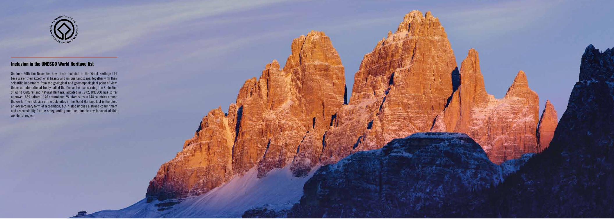
Inclusion in the unesco World Heritage list
On June 26th the Dolomites have been included in the World Heritage List because of their exceptional beauty and unique landscape, together with their scientific importance from the geological and geomorphological point of view. Under an international treaty called the Convention concerning the Protection of World Cultural and Natural Heritage, adopted in 1972, UNESCO has so far approved 689 cultural, 176 natural and 25 mixed sites in 148 countries around the world. The inclusion of the Dolomites in the World Heritage List is therefore an extraordinary form of recognition, but it also implies a strong commitment and responsibility for the safeguarding and sustainable development of this wonderful region.
4 5
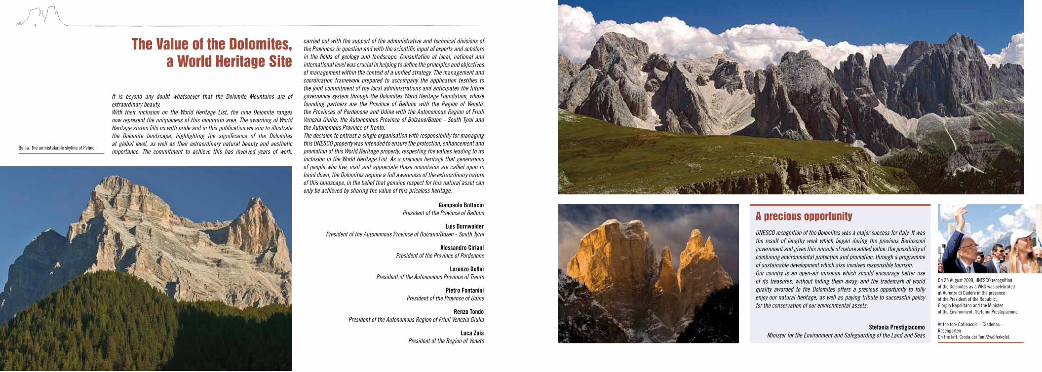
It is beyond any doubt whatsoever that the Dolomite Mountains are of extraordinary beauty.With their inclusion on the World Heritage List, the nine Dolomite ranges now represent the uniqueness of this mountain area. The awarding of World Heritage status fills us with pride and in this publication we aim to illustrate the Dolomite landscape, highlighting the significance of the Dolomites at global level, as well as their extraordinary natural beauty and aesthetic importance. The commitment to achieve this has involved years of work,
The Value of the Dolomites, a World Heritage site
carried out with the support of the administrative and technical divisions of the Provinces in question and with the scientific input of experts and scholars in the fields of geology and landscape. Consultation at local, national and international level was crucial in helping to define the principles and objectives of management within the context of a unified strategy. The management and coordination framework prepared to accompany the application testifies to the joint commitment of the local administrations and anticipates the future governance system through the Dolomites World Heritage Foundation, whose founding partners are the Province of Belluno with the Region of Veneto, the Provinces of Pordenone and Udine with the Autonomous Region of Friuli Venezia Giulia, the Autonomous Province of Bolzano/Bozen - South Tyrol and the Autonomous Province of Trento.The decision to entrust a single organisation with responsibility for managing this UNESCO property was intended to ensure the protection, enhancement and promotion of this World Heritage property, respecting the values leading to its inclusion in the World Heritage List. As a precious heritage that generations of people who live, visit and appreciate these mountains are called upon to hand down, the Dolomites require a full awareness of the extraordinary nature of this landscape, in the belief that genuine respect for this natural asset can only be achieved by sharing the value of this priceless heritage.
A precious opportunityUNESCO recognition of the Dolomites was a major success for Italy. It was the result of lengthy work which began during the previous Berlusconi government and gives this miracle of nature added value: the possibility of combining environmental protection and promotion, through a programme of sustainable development which also involves responsible tourism. Our country is an open-air museum which should encourage better use of its treasures, without hiding them away, and the trademark of world quality awarded to the Dolomites offers a precious opportunity to fully enjoy our natural heritage, as well as paying tribute to successful policy for the conservation of our environmental assets.
Stefania PrestigiacomoMinister for the Environment and Safeguarding of the Land and Seas
On 25 August 2009, UNESCO recognition of the Dolomites as a WHS was celebrated at Auronzo di Cadore in the presence of the President of the Republic, Giorgio Napolitano and the Minister of the Environment, Stefania Prestigiacomo. At the top: Catinaccio – Ciadenac – Rosengarten On the left: Croda dei Toni/Zwölferkofel.
Gianpaolo Bottacin President of the Province of Belluno
Luis Durnwalder President of the Autonomous Province of Bolzano/Bozen - South Tyrol
Alessandro Ciriani President of the Province of Pordenone
Lorenzo Dellai President of the Autonomous Province of Trento
Pietro Fontanini President of the Province of Udine
Renzo Tondo President of the Autonomous Region of Friuli Venezia Giulia
Luca Zaia President of the Region of Veneto
Below: the unmistakable skyline of Pelmo.

6 7
“I grew up in the Dolomites, then, after more than 1,000 climbing tours at home, I climbed on thousands of mountains around the world. My conclusion: no mountain can compete with the beauty of the Dolomites. The Dolomites are distinctive: in their variety of morphology, geology and especially in the type of landscape, which is characterised by the exciting contrast between flat and gentle fields and vertical cliffs. Not only in my opinion does the rocky landscape between Brenta and Udine, Sas de Putia and Pordenone offer the most beautiful mountains in the world, many other experts share this opinion, too […].” (Reinhold Messner, letter written in support to the nomination, 27 December 2007)
Il percorso della candidatura, avviato nel dicembre 2004 dallo Stato Italiano e condotto in questi anni dalle cinque Province di Belluno, Bolzano, Pordenone, Trento e Udine e dalle Regioni di riferimento, si è articolato attraverso varie fasi di approfondimento e di valutazione, rivelando l’area dolomitica come un patrimonio montano che è al tempo stesso bene naturale e fattore identitario di primaria importanza. L’unicità di queste montagne, riconosciuta dall’UNESCO, sta nel loro valore geo logico e paesaggistico, considerato come l’espressione più profonda e più viva dell’identità del territorio, come sintesi di uomo e di ambiente, di attività e di usi, sedimentatisi in queste vallate nel corso dei secoli e, rispetto ai quali, gli elementi naturali risultano imprescindibili.Questo riconoscimento rappresenta dunque l’opportunità di condividere a livel-lo territoriale un progetto di sviluppo sostenibile basato sull’idea di “montagna delle identità”. Qui il senso del limite – assieme alla valorizzazione del territorio e delle culture – crea il sentire comune delle genti che popolano le alte quote e ha un ruolo centrale nell’assicurare la partecipazione di tutti per veicolare al meglio obiettivi e significati.L’iscrizione delle Dolomiti nel Patrimonio Mondiale si configura in definitiva come un’occasione straordinaria per ragionare sui temi della montagna e sulla specificità anche culturale del territorio dolomitico. Tutti temi da affrontare con nuova consapevolezza e responsabilità amministrativa per garantire nel tempo la durata dei valori universali che l’UNESCO ha qui riconosciuto.
Le Dolomiti, montagne delle identità
In the previous page: the lake d’Antorno and the Tre Cime in the background Left: Odle, Val di Funes.
Matteo Toscani Councillor for Tourism, Parks and Reserves and UNESCO Heritage
for the Province of Belluno
Michl Laimer Councillor for Town-Planning, Energy and the Environment
for the Autonomous Province of Bolzano/Bozen - South Tyrol
Giuseppe Verdichizzi Municipal Councillor for the Territorial Planning and Dolomites UNESCO
for the Provincia di Pordenone
Mauro Gilmozzi Councillor for Town-Planning and Local Authorities
for the Autonomous Province of Trento
Ottorino Faleschini Councillor for Development of the Mountains, Civil Defence, Hunting and Fishing
for the Province of Udine
The Foundation Dolomiti – Dolomiten – Dolomites – Dolomitis UNESCO was establi-shed on 13 May 2010, in order to ensure an efficient management of the Dolomites for the protection and use of this site, in relation to its inclusion in the World Heri-tage List and to the UNESCO requirements. The Dolomites occupy a territory cha-racterised by nine serial sites and are located in a geographic area which involves five Italian provinces (Belluno, Bolzano, Pordenone, Trento and Udine), belonging to three different regions (Friuli Venezia Giulia, Trentino Alto Adige and Veneto).The Foundation, which has been specially established to better manage this com-plex territory, is unrivalled among the sites of the UNESCO World Heritage and should represent a virtuous mode of management for these unique geographic areas.The Foundation aims to contribute to a sustainable development of the Dolomites-UNESCO World Heritage, to promote the collaboration and communication between
Foundation Dolomiti – Dolomiten – Dolomites - Dolomitis unesco
Board of directorsAlberto Vettoretto Municipal Councillor Provincia di Belluno (Chairman)Michl Laimer Municipal Councillor Provincia Autonoma di TrentoGiuseppe Verdichizzi Municipal Councillor Provincia di PordenoneMauro Gilmozzi Municipal Councillor Provincia Autonoma di TrentoOttorino Faleschini Municipal Councillor Provincia di Udine
scientific committeeRoland DellagiacomaCesare LasenMauro PascoliniAnnibale SalsaMarco Tonon
secretary GeneralGiovanni Campeol
the founding members, to set up discussion groups and management panels and to spread awareness about the UNESCO Heritage.The creation of the Foundation is above all a cultural challenge, since very diverse communities join together with the goal to work in one system for managing a world “value”. This is an organisational rarity in today’s social and political framework, where the cultural value of the local identity is often interpreted as a condition to develop self-referential institutions which show an atomistic and conservative refusal to collaborate and oppose any territorial confrontation/competition.The registered offices are in Belluno, whereas the Chairmanship of the Foundation is assigned in rotation, so as to involve all the Provinces where the property is located. Belluno is the first Province which hosts the Chairman, in charge for three years (until 13 May 2013). Then, in alphabetical order and always for three years, each of the other Provinces involved will in turn host the Chairman.
“…The landscape is by definition the expression of geography through the cultural filter of the observer. As a consequence the contrasts between beautifu and ugly, pleasant and unpleasant are not only the result of what you see, but above all of what you interpret. We can affirm … together with Munch, that the landscape of nature is not the goal; instead, it is the way to express one’s own emotions through art. Thus, the geographical sites are the containers where to experiment “emotional shapes”, bold alliances which allow to aggregate and separate the most different landscapes, with the ultimate goal to continuously interpret ourselves through the surroundings...” (Giovanni Campeol, from the preface to the book DOLOMITINEWYORK, October 2010)

9
contents
The Dolomites offer an extraordinary collection of vertical sculptures, such as needles, spires, towers and pinnacles. Gusèla del Vescovà, Schiara.
The way in which these natural forms taken on specific volumetric shapes (prisms and parallelepipeds) means that these mountains resemble the ruins of ancient buildings or remote civilisations. Campanil Basso, Brenta.
“The Campanile di Val Montanaia represents a wonder of nature without comparison in the whole of the Alps.” (Tita Piaz)
“To the left – a continuation, indeed, of the Rochetta – the Bec di Mezzodi and the ridge of Beccolungo [Croda da Lago], stand out like a row of jagged teeth.” (Amelia B. Edwards, Untrodden Peaks and Unfrequented Valleys, 1872)
Croda da Lago and Lastoi di Formin.
The Dolomites as serial property 10
What makes the Dolomites unique in the world? 11
The Integrity of the Dolomites 12
The sublime beauty of the Pale Mountains 14
A journey through time and space 20
A stone book 22
Spectacular peaks carved out through time 24
Pelmo, Croda da Lago 28
Marmolada 30
Pale di San Martino, San Lucano, Dolomiti Bellunesi, Vette Feltrine 32
Dolomiti Friulane and d’Oltre Piave 34
Dolomiti Settentrionali/Nördliche Dolomiten 36
Puez-Odle/Puez-Geisler 38
Sciliar-Catinaccio/Schlern-Rosengarten, Latemar 40
Bletterbach 42
Dolomiti di Brenta 44
Governance strategy 46
8
THE VALUES OF THE DOLOMITES
THE SYSTEMS OF THE DOLOMITES
10 11
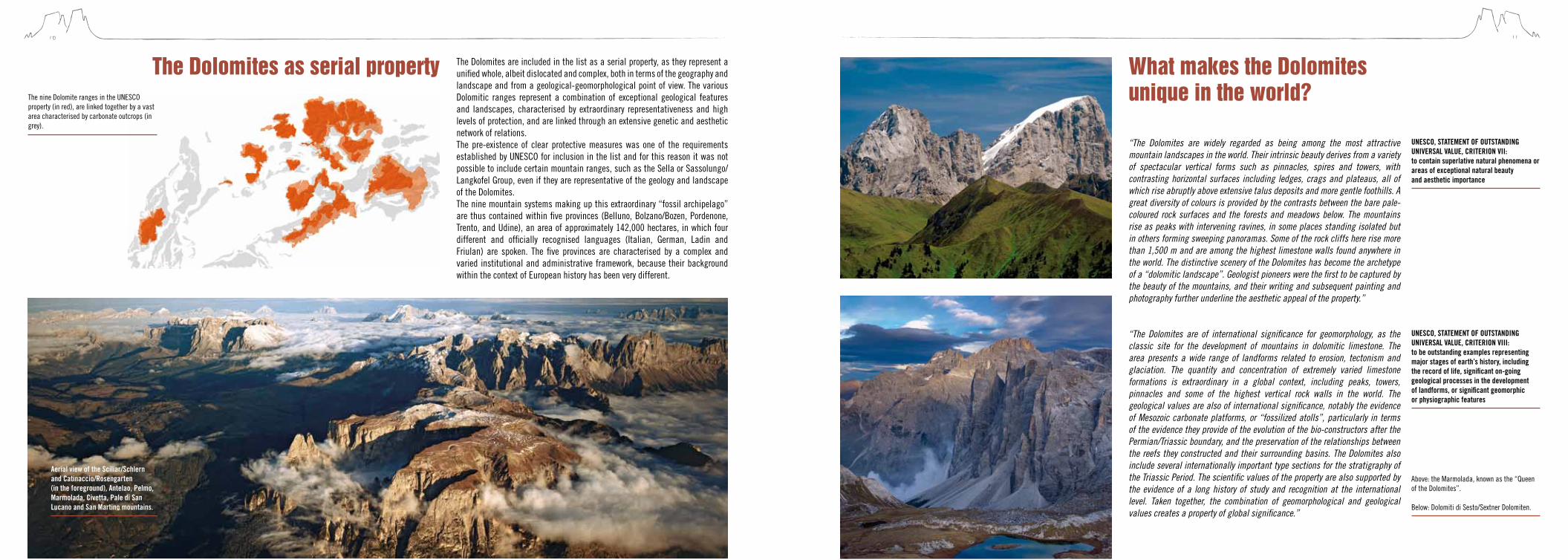
The Dolomites as serial property The Dolomites are included in the list as a serial property, as they represent a unified whole, albeit dislocated and complex, both in terms of the geography and landscape and from a geological-geomorphological point of view. The various Dolomitic ranges represent a combination of exceptional geological features and landscapes, characterised by extraordinary representativeness and high levels of protection, and are linked through an extensive genetic and aesthetic network of relations.The pre-existence of clear protective measures was one of the requirements established by UNESCO for inclusion in the list and for this reason it was not possible to include certain mountain ranges, such as the Sella or Sassolungo/Langkofel Group, even if they are representative of the geology and landscape of the Dolomites.The nine mountain systems making up this extraordinary “fossil archipelago” are thus contained within five provinces (Belluno, Bolzano/Bozen, Pordenone, Trento, and Udine), an area of approximately 142,000 hectares, in which four different and officially recognised languages (Italian, German, Ladin and Friulan) are spoken. The five provinces are characterised by a complex and varied institutional and administrative framework, because their background within the context of European history has been very different.
Above: the Marmolada, known as the “Queen of the Dolomites”. Below: Dolomiti di Sesto/Sextner Dolomiten.
“The Dolomites are widely regarded as being among the most attractive mountain landscapes in the world. Their intrinsic beauty derives from a variety of spectacular vertical forms such as pinnacles, spires and towers, with contrasting horizontal surfaces including ledges, crags and plateaus, all of which rise abruptly above extensive talus deposits and more gentle foothills. A great diversity of colours is provided by the contrasts between the bare pale-coloured rock surfaces and the forests and meadows below. The mountains rise as peaks with intervening ravines, in some places standing isolated but in others forming sweeping panoramas. Some of the rock cliffs here rise more than 1,500 m and are among the highest limestone walls found anywhere in the world. The distinctive scenery of the Dolomites has become the archetype of a “dolomitic landscape”. Geologist pioneers were the first to be captured by the beauty of the mountains, and their writing and subsequent painting and photography further underline the aesthetic appeal of the property.”
“The Dolomites are of international significance for geomorphology, as the classic site for the development of mountains in dolomitic limestone. The area presents a wide range of landforms related to erosion, tectonism and glaciation. The quantity and concentration of extremely varied limestone formations is extraordinary in a global context, including peaks, towers, pinnacles and some of the highest vertical rock walls in the world. The geological values are also of international significance, notably the evidence of Mesozoic carbonate platforms, or “fossilized atolls”, particularly in terms of the evidence they provide of the evolution of the bio-constructors after the Permian/Triassic boundary, and the preservation of the relationships between the reefs they constructed and their surrounding basins. The Dolomites also include several internationally important type sections for the stratigraphy of the Triassic Period. The scientific values of the property are also supported by the evidence of a long history of study and recognition at the international level. Taken together, the combination of geomorphological and geological values creates a property of global significance.”
What makes the Dolomites unique in the world?The nine Dolomite ranges in the UNESCO
property (in red), are linked together by a vast area characterised by carbonate outcrops (in grey).
UNESCO, STATEMENT OF OUTSTANDING UNIVERSAL VALUE, CRITERION VII: to contain superlative natural phenomena or areas of exceptional natural beauty and aesthetic importance
UNESCO, STATEMENT OF OUTSTANDING UNIVERSAL VALUE, CRITERION VIII: to be outstanding examples representing major stages of earth’s history, including the record of life, significant on-going geological processes in the development of landforms, or significant geomorphic or physiographic features
Aerial view of the Sciliar/Schlern and Catinaccio/Rosengarten (in the foreground), Antelao, Pelmo, Marmolada, Civetta, Pale di San Lucano and San Martino mountains.
12 13
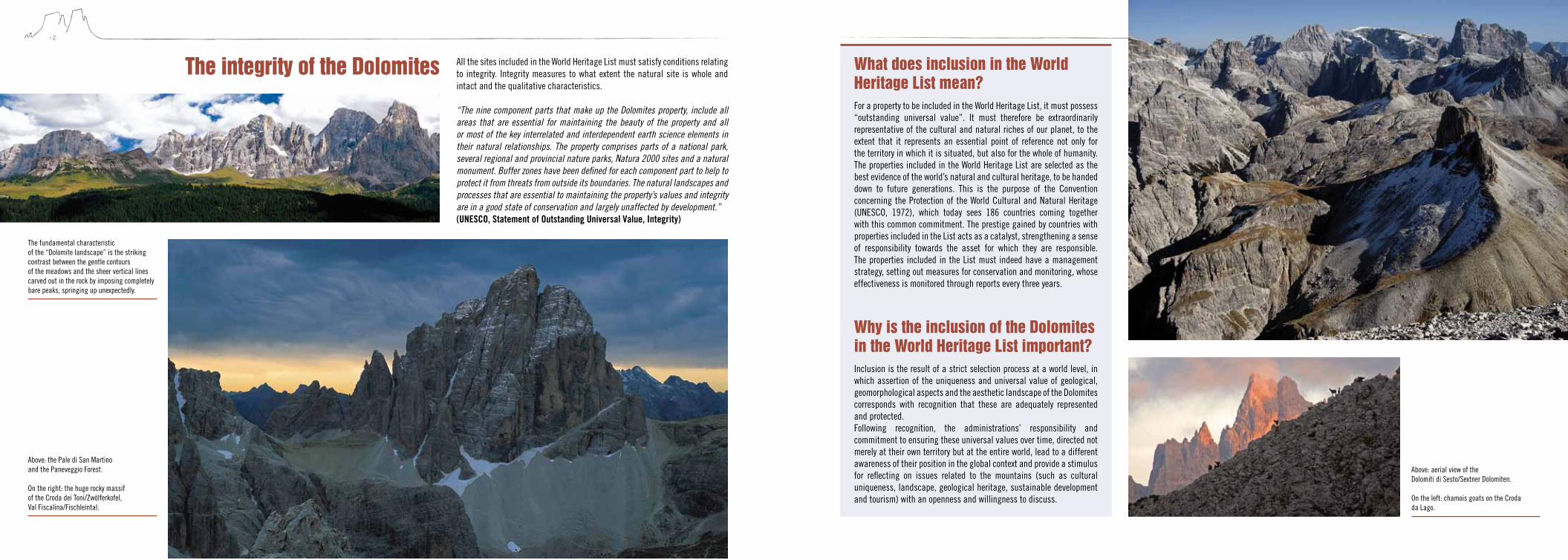
Above: the Pale di San Martino and the Paneveggio Forest. On the right: the huge rocky massif of the Croda dei Toni/Zwölferkofel, Val Fiscalina/Fischleintal.
All the sites included in the World Heritage List must satisfy conditions relating to integrity. Integrity measures to what extent the natural site is whole and intact and the qualitative characteristics.
“The nine component parts that make up the Dolomites property, include all areas that are essential for maintaining the beauty of the property and all or most of the key interrelated and interdependent earth science elements in their natural relationships. The property comprises parts of a national park, several regional and provincial nature parks, Natura 2000 sites and a natural monument. Buffer zones have been defined for each component part to help to protect it from threats from outside its boundaries. The natural landscapes and processes that are essential to maintaining the property’s values and integrity are in a good state of conservation and largely unaffected by development.” (UNESCO, Statement of Outstanding Universal Value, Integrity)
The integrity of the Dolomites
Above: aerial view of the Dolomiti di Sesto/Sextner Dolomiten. On the left: chamois goats on the Croda da Lago.
What does inclusion in the World Heritage List mean?For a property to be included in the World Heritage List, it must possess “outstanding universal value”. It must therefore be extraordinarily representative of the cultural and natural riches of our planet, to the extent that it represents an essential point of reference not only for the territory in which it is situated, but also for the whole of humanity. The properties included in the World Heritage List are selected as the best evidence of the world’s natural and cultural heritage, to be handed down to future generations. This is the purpose of the Convention concerning the Protection of the World Cultural and Natural Heritage (UNESCO, 1972), which today sees 186 countries coming together with this common commitment. The prestige gained by countries with properties included in the List acts as a catalyst, strengthening a sense of responsibility towards the asset for which they are responsible. The properties included in the List must indeed have a management strategy, setting out measures for conservation and monitoring, whose effectiveness is monitored through reports every three years.
Why is the inclusion of the Dolomites in the World Heritage List important?Inclusion is the result of a strict selection process at a world level, in which assertion of the uniqueness and universal value of geological, geomorphological aspects and the aesthetic landscape of the Dolomites corresponds with recognition that these are adequately represented and protected.Following recognition, the administrations’ responsibility and commitment to ensuring these universal values over time, directed not merely at their own territory but at the entire world, lead to a different awareness of their position in the global context and provide a stimulus for reflecting on issues related to the mountains (such as cultural uniqueness, landscape, geological heritage, sustainable development and tourism) with an openness and willingness to discuss.
The fundamental characteristic of the “Dolomite landscape” is the striking contrast between the gentle contours of the meadows and the sheer vertical lines carved out in the rock by imposing completely bare peaks, springing up unexpectedly.

14 15
The sublime beauty of the Pale Mountains
The Dolomites have always had an enormous impact on the imagination of all those who have seen them. The imposing nature of these stone giants has inspired the people inhabiting them from prehistoric times, to the extent that they have become an essential part of their cultural identity. Then, after they were “discovered” by science, romantic travellers recognised them as the embodiment of those ideals that landscape painters had hitherto only imagined.No one has remained immune to their extraordinary fascination, to the extent so that they are universally considered “the most beautiful mountains on Earth”.So why are the Dolomites so beautiful? What is the secret of their extraordinary appeal?
Aesthetic importanceThe Dolomites are considered a global point of reference for the aesthetics of the sublime. For this field of philosophy, developed in the years immediately preceding the “discovery” of these mountains, the peaks of the Dolomites became a model of fundamental importance and therefore contributed to the definition of the modern concept of natural beauty.The very first pictures of these mountains were not paintings or portraits but descriptions, words that told of extraordinary visions and powerful emotions that invaded and occupied the mind – with an almost inescapable force – as well as the first scientific reports and early travellers’ accounts. The words with which the characteristics of the Dolomites were expressed correspond exactly to the categories of the sublime: verticality, grandeur, monumentality, the torment of forms, essential purity, the intensity of colours, astonishment, mystical asceticism and transcendence.The reference to the sublime is very important. The sublime is in fact an aesthetic category expressly referring to nature. The famous Red Book by John Murray, dating back to 1837 (the first Dolomites travel guide in English), uses precisely the adjective “sublime” to define the Dolomite landscape: “Altogether they impart an air of novelty and sublime grandeur to the scene which can only be appreciated by those who have viewed it.”
Scenic valuesThe original landscape analysis method developed specifically in relation to the nomination and considered to be innovative by the advisory bodies of UNESCO, highlighted the fact that the Dolomites represent a universal archetype in terms of the mountain landscape: the “Dolomite landscape”.
“No work of art can be great and sublime as it deceives; to be otherwise is the prerogative of nature only.” (Edmund Burke, A philosophical inquiry into the origin of our ideas of the Sublime and Beautiful, 1757)
There are a number of key characteristics in this kind of landscape, represented first of all by an extremely complex topography, distinguished by the frequency of separate mountain groups set side by side in a particularly restricted environment. Secondly there is an unusual variety of forms, both vertical (cliffs, needles, spires, pinnacles, towers and jags) and horizontal (ledges, roofs, plates, crags, plateaus, summit tablelands). However, the Dolomites are known above all for the exceptional variety of colours and the extraordinary contrast between the soft lines of the meadows and the completely bare mountain peaks which spring up unexpectedly. Furthermore, the possibility of classifying these “carbonate structures” into recognisable geometric figures and specific volumetric shapes (prisms, parallelepiped, cones) has led to an interpretation of these mountains as artificial structures rather than simple natural expressions.
The imaginative vision of the first inhabitants led them to liken the mountains to the vestiges of a legendary epic world, thus projecting the region into a mythical dimension. More recently, the gigantic nature of their “architecture” and the fantastic relationships in scale led the intellectual romantics to imagine them as the ruins of a city inhabited by Titans and Le Corbusier (1887 – 1965) to define them as “les plus belles constructions du monde”. Their evocative power is such that their name has also been extended to other mountains elsewhere. There are indeed “Dolomites” in France (Dolomites Françaises), Austria (Lienzer Dolomiten, Salzburger Dolomiten), Switzerland (Unterengadiner Dolomiten), elsewhere in Italy (Lucanian Dolomites, Sicilian Dolomites), Norway (the Porsangerdolomitt) and Slovenia (Polhograjski Dolomiti).
Like ancient monuments or modern skyscrapers, the “carbonate buildings” of the Dolomites have colossal proportions and are characterised by isolated forms, perfectly vertical faces and clearly-defined bases.
On the facing page: J. Gilbert, the Valle del Vajolet/Vajolettal with the Catinaccio/Rosengarten watercolour, 1864. Above: Dolomites (poster, 1930). On the left: Dolomiti d’Ampezzo.

17
“Full opposite to us rose a colossal rock, one of the most prodigious monuments of Nature’s forces. Its lower portion rose in diminishing stories like the Tower of Babel of old Bible pictures. Above it was a perfect precipice, an upright block, the top of which was 4,000 to 4,500 feet above our heads. Behind this gigantic keep a vast mountain fortress stretched out its long lines of turrets and bastions. But as we approached its base the great tower rose alone and unsupported, and the boldness of its outline became almost incredible[…]; it combines to a great extent the noble solidity of the Swiss peak with the peculiar upright structure which gives dolomite its strange resemblance to human architecture. […] On our left was a second massive rock castle, the Cima di Brenta, connected with the Cima Tosa by the Fulmini (sic) di Brenta, a long line of flame-like pinnacles of the strangest shapes, some of them seeming to bulge near the top like a Russian steeple.” (Douglas William Freshfield, The Italian Alps, 1875)
Cima Brenta Alta, Sfulmini, Campanil Basso, Torre di Brenta.
natural phenomenaThe visual excitement is amplified by a natural phenomenon specific to these mountains, the so-called Enrosadira. Due to the specific structure and composition of the Dolomitic rock, during the day the rock faces react dramatically to changes in the light. They are characterised by strong warm colours (oranges, reds and purples) at sunrise and sunset, but pale and evanescent in the midday light, while at twilight and in the moonlight the mountains have a cold, unearthly aspect. This has given rise to the name Monti Pallidi – the Pale Mountains. Furthermore, it should be noted that while the Dolomites do not have the highest peaks, the biggest glaciers or the most extensive areas of wilderness, they represent the only area in the world where pale dolomite and dark volcaniclastic rocks are found together. The Dolomite region is also characterised by an unusual concentration of peaks exceeding 3,000 metres (around one hundred) and a remarkably large number of small glaciers and perennial snowfields at relatively low altitude. Vertical cliffs of incredible height (from 800 to 1,600 metres) combine with deep canyons (from 500 to 1,500 metres), offering a morphological diversity which enriches the natural beauty of the Dolomites.
Above: dawn over the Tre Cime di Lavaredo/Drei Zinnen. On the right: the profile of the Sciliar/Schlern with the Santner and Euringer peaks in the midst of the clouds.
“[…] the mists roll away, and the huge aiguilles of the Schlern start out grandly from above the woods.” (Amelia B. Edwards, Untrodden Peaks and Unfrequented Valleys, 1872)
19
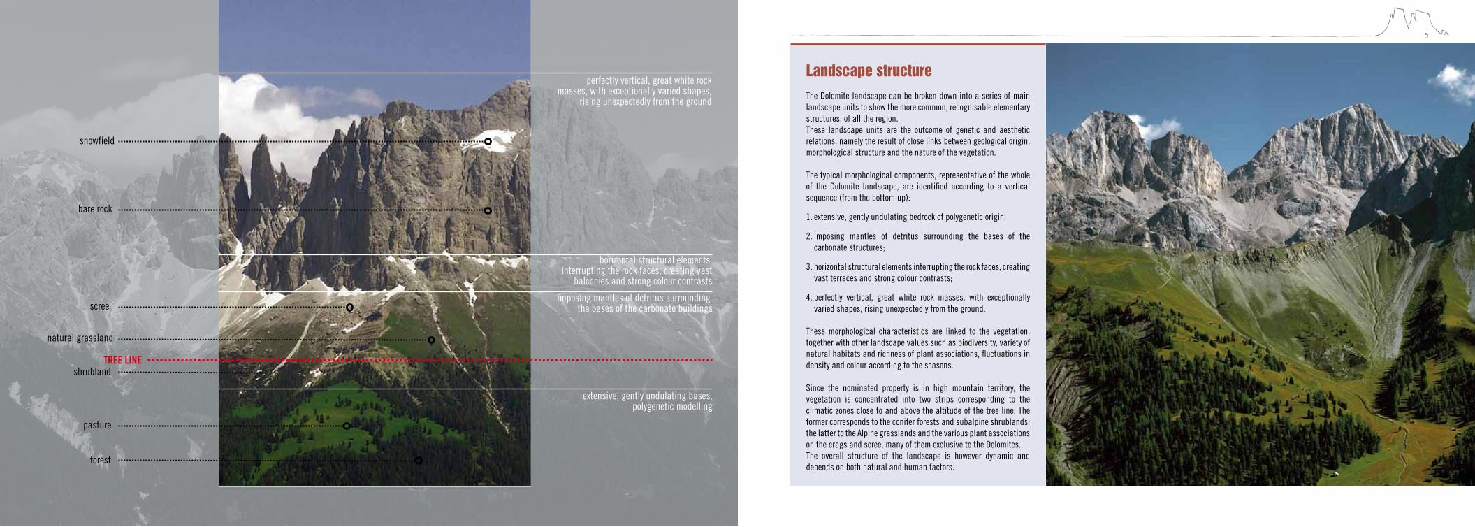
Landscape structure
The Dolomite landscape can be broken down into a series of main landscape units to show the more common, recognisable elementary structures, of all the region.These landscape units are the outcome of genetic and aesthetic relations, namely the result of close links between geological origin, morphological structure and the nature of the vegetation.
The typical morphological components, representative of the whole of the Dolomite landscape, are identified according to a vertical sequence (from the bottom up):
1. extensive, gently undulating bedrock of polygenetic origin;
2. imposing mantles of detritus surrounding the bases of the carbonate structures;
3. horizontal structural elements interrupting the rock faces, creating vast terraces and strong colour contrasts;
4. perfectly vertical, great white rock masses, with exceptionally varied shapes, rising unexpectedly from the ground.
These morphological characteristics are linked to the vegetation, together with other landscape values such as biodiversity, variety of natural habitats and richness of plant associations, fluctuations in density and colour according to the seasons.
Since the nominated property is in high mountain territory, the vegetation is concentrated into two strips corresponding to the climatic zones close to and above the altitude of the tree line. The former corresponds to the conifer forests and subalpine shrublands; the latter to the Alpine grasslands and the various plant associations on the crags and scree, many of them exclusive to the Dolomites.The overall structure of the landscape is however dynamic and depends on both natural and human factors.
snowfield
bare rock
scree
natural grassland
shrubland TREE LINE
pasture
forest
extensive, gently undulating bases, polygenetic modelling
imposing mantles of detritus surrounding the bases of the carbonate buildings
horizontal structural elements interrupting the rock faces, creating vast
balconies and strong colour contrasts
perfectly vertical, great white rock masses, with exceptionally varied shapes,
rising unexpectedly from the ground
20
A journey through time and space
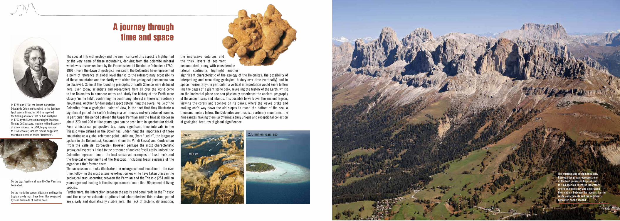
The special link with geology and the significance of this aspect is highlighted by the very name of these mountains, deriving from the dolomite mineral which was discovered here by the French scientist Déodat de Dolomieu (1750-1801). From the dawn of geological research, the Dolomites have represented a point of reference at global level thanks to the extraordinary accessibility of these mountains and the clarity with which the geological phenomena can be observed. Some of the founding principles of Earth Science were deduced here. Even today, scientists and researchers from all over the world come to the Dolomites to compare notes and study the history of the Earth more closely “in the field”, confirming the continuing interest in these extraordinary mountains. Another fundamental aspect determining the overall value of the Dolomites from a geological point of view, is the fact that they illustrate a significant part of the Earth’s history in a continuous and very detailed manner. In particular, the period between the Upper Permian and the Triassic (between about 270 and 200 million years ago) can be seen here in spectacular detail. From a historical perspective too, many significant time intervals in the Triassic were defined in the Dolomites, underlining the importance of these mountains as a global reference point: Ladinian, (from “Ladin”, the language spoken in the Dolomites), Fassanian (from the Val di Fassa) and Cordevolian (from the Valle del Cordevole). However, perhaps the most characteristic geological aspect is linked to the presence of ancient fossil atolls. Indeed, the Dolomites represent one of the best conserved examples of fossil reefs and the tropical environments of the Mesozoic, including fossil evidence of the organisms that formed them. The succession of rocks illustrates the resurgence and evolution of life over time, following the most extensive extinction known to have taken place in the geological eras, occurring between the Permian and the Triassic (251 million years ago) and leading to the disappearance of more than 90 percent of living species. Furthermore, the interaction between the atolls and coral reefs in the Triassic and the massive volcanic eruptions that characterised this distant period are clearly and dramatically visible here. The lack of tectonic deformation,
the impressive outcrops and the thick layers of sediment accumulated, along with considerable lateral continuity, highlight another significant characteristic of the geology of the Dolomites: the possibility of interpreting and recounting geological history over time (vertically) and in space (horizontally). In particular, a vertical interpretation would seem to flow like the pages of a giant stone book, revealing the history of the Earth, whilst on the horizontal plane one can physically experience the ancient geography of the ancient seas and islands. It is possible to walk over the ancient lagoon, viewing the corals and sponges on its banks, where the waves broke and making one’s way down the old slopes to reach the bottom of the sea, a thousand meters below. The Dolomites are thus extraordinary mountains, the nine ranges making them up offering a truly unique and exceptional collection of geological features of global significance.
The western side of the Catinaccio/Rosengarten group represents one of the best preserved tropical reefs. It is an open-air research laboratory, where one can study and understand the relations between the lagoons, barrier reefs, escarpments and the sediments deposited on the seabed.
On the top: fossil coral from the San Cassiano Formation. On the right: the current situation and how the tropical atolls must have been like, separated by seas hundreds of metres deep.
In 1789 and 1790, the French naturalist Déodat de Dolomieu travelled to the Southern Tyrol several times. In 1791 he reported the finding of a rock that he had analysed in 1792 by the Swiss mineralogist Théodore-Nicolas De Saussure, leading to the discovery of a new mineral. In 1794, to pay homage to its discoverer, Richard Kirwan suggested that the mineral be called “Dolomite”.
deep sea
230 million years agoToday
lagoon
island
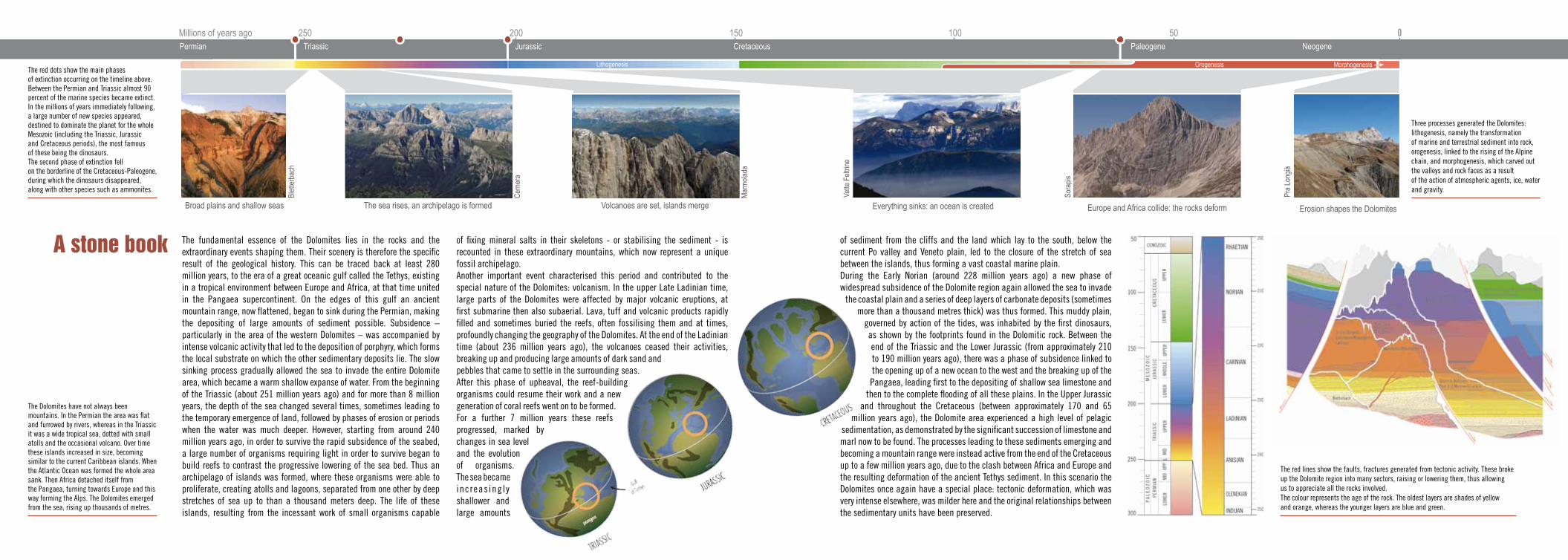
The fundamental essence of the Dolomites lies in the rocks and the extraordinary events shaping them. Their scenery is therefore the specific result of the geological history. This can be traced back at least 280 million years, to the era of a great oceanic gulf called the Tethys, existing in a tropical environment between Europe and Africa, at that time united in the Pangaea supercontinent. On the edges of this gulf an ancient mountain range, now flattened, began to sink during the Permian, making the depositing of large amounts of sediment possible. Subsidence – particularly in the area of the western Dolomites – was accompanied by intense volcanic activity that led to the deposition of porphyry, which forms the local substrate on which the other sedimentary deposits lie. The slow sinking process gradually allowed the sea to invade the entire Dolomite area, which became a warm shallow expanse of water. From the beginning of the Triassic (about 251 million years ago) and for more than 8 million years, the depth of the sea changed several times, sometimes leading to the temporary emergence of land, followed by phases of erosion or periods when the water was much deeper. However, starting from around 240 million years ago, in order to survive the rapid subsidence of the seabed, a large number of organisms requiring light in order to survive began to build reefs to contrast the progressive lowering of the sea bed. Thus an archipelago of islands was formed, where these organisms were able to proliferate, creating atolls and lagoons, separated from one other by deep stretches of sea up to than a thousand meters deep. The life of these islands, resulting from the incessant work of small organisms capable
of sediment from the cliffs and the land which lay to the south, below the current Po valley and Veneto plain, led to the closure of the stretch of sea between the islands, thus forming a vast coastal marine plain. During the Early Norian (around 228 million years ago) a new phase of widespread subsidence of the Dolomite region again allowed the sea to invade
the coastal plain and a series of deep layers of carbonate deposits (sometimes more than a thousand metres thick) was thus formed. This muddy plain,
governed by action of the tides, was inhabited by the first dinosaurs, as shown by the footprints found in the Dolomitic rock. Between the end of the Triassic and the Lower Jurassic (from approximately 210 to 190 million years ago), there was a phase of subsidence linked to the opening up of a new ocean to the west and the breaking up of the Pangaea, leading first to the depositing of shallow sea limestone and
then to the complete flooding of all these plains. In the Upper Jurassic and throughout the Cretaceous (between approximately 170 and 65
million years ago), the Dolomite area experienced a high level of pelagic sedimentation, as demonstrated by the significant succession of limestone and marl now to be found. The processes leading to these sediments emerging and becoming a mountain range were instead active from the end of the Cretaceous up to a few million years ago, due to the clash between Africa and Europe and the resulting deformation of the ancient Tethys sediment. In this scenario the Dolomites once again have a special place: tectonic deformation, which was very intense elsewhere, was milder here and the original relationships between the sedimentary units have been preserved.
A stone book of fixing mineral salts in their skeletons - or stabilising the sediment - is recounted in these extraordinary mountains, which now represent a unique fossil archipelago. Another important event characterised this period and contributed to the special nature of the Dolomites: volcanism. In the upper Late Ladinian time, large parts of the Dolomites were affected by major volcanic eruptions, at first submarine then also subaerial. Lava, tuff and volcanic products rapidly filled and sometimes buried the reefs, often fossilising them and at times, profoundly changing the geography of the Dolomites. At the end of the Ladinian time (about 236 million years ago), the volcanoes ceased their activities, breaking up and producing large amounts of dark sand and pebbles that came to settle in the surrounding seas. After this phase of upheaval, the reef-building organisms could resume their work and a new generation of coral reefs went on to be formed. For a further 7 million years these reefs progressed, marked by changes in sea level and the evolution of organisms. The sea became increas ing l y shallower and large amounts
Volcanoes are set, islands merge Everything sinks: an ocean is created Europe and Africa collide: the rocks deform
Pra
Long
ià
Sora
pis
Mar
mol
ada
Cer
nera
Vette
Fel
trine
250 200 150 100 50Millions of years ago 0CretaceousTriassic Jurassic Paleogene Neogene
Lithogenesis Orogenesis Morphogenesis
Permian
Erosion shapes the Dolomites
Blet
terb
ach
The sea rises, an archipelago is formedBroad plains and shallow seas
The red dots show the main phases of extinction occurring on the timeline above. Between the Permian and Triassic almost 90 percent of the marine species became extinct. In the millions of years immediately following, a large number of new species appeared, destined to dominate the planet for the whole Mesozoic (including the Triassic, Jurassic and Cretaceous periods), the most famous of these being the dinosaurs. The second phase of extinction fell on the borderline of the Cretaceous-Paleogene, during which the dinosaurs disappeared, along with other species such as ammonites.
The Dolomites have not always been mountains. In the Permian the area was flat and furrowed by rivers, whereas in the Triassic it was a wide tropical sea, dotted with small atolls and the occasional volcano. Over time these islands increased in size, becoming similar to the current Caribbean islands. When the Atlantic Ocean was formed the whole area sank. Then Africa detached itself from the Pangaea, turning towards Europe and this way forming the Alps. The Dolomites emerged from the sea, rising up thousands of metres.
The red lines show the faults, fractures generated from tectonic activity. These broke up the Dolomite region into many sectors, raising or lowering them, thus allowing us to appreciate all the rocks involved. The colour represents the age of the rock. The oldest layers are shades of yellow and orange, whereas the younger layers are blue and green.
Three processes generated the Dolomites: lithogenesis, namely the transformation of marine and terrestrial sediment into rock, orogenesis, linked to the rising of the Alpine chain, and morphogenesis, which carved out the valleys and rock faces as a result of the action of atmospheric agents, ice, water and gravity.
24 25
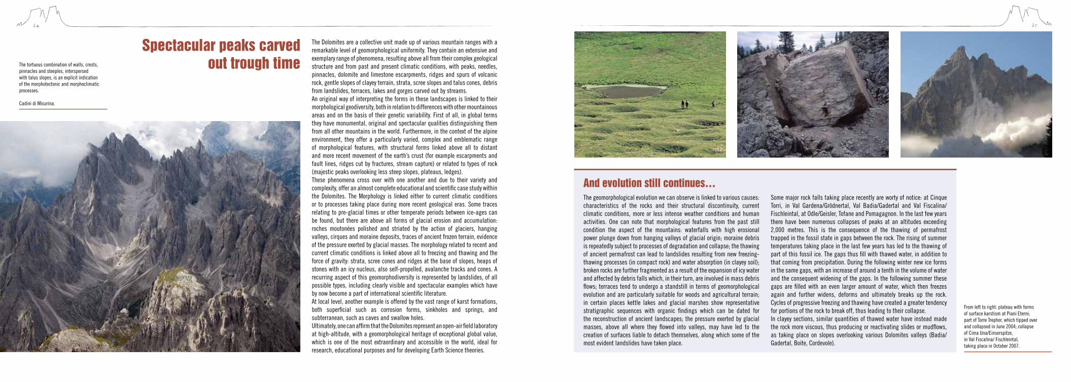
The Dolomites are a collective unit made up of various mountain ranges with a remarkable level of geomorphological uniformity. They contain an extensive and exemplary range of phenomena, resulting above all from their complex geological structure and from past and present climatic conditions, with peaks, needles, pinnacles, dolomite and limestone escarpments, ridges and spurs of volcanic rock, gentle slopes of clayey terrain, strata, scree slopes and talus cones, debris from landslides, terraces, lakes and gorges carved out by streams.An original way of interpreting the forms in these landscapes is linked to their morphological geodiversity, both in relation to differences with other mountainous areas and on the basis of their genetic variability. First of all, in global terms they have monumental, original and spectacular qualities distinguishing them from all other mountains in the world. Furthermore, in the context of the alpine environment, they offer a particularly varied, complex and emblematic range of morphological features, with structural forms linked above all to distant and more recent movement of the earth’s crust (for example escarpments and fault lines, ridges cut by fractures, stream capture) or related to types of rock (majestic peaks overlooking less steep slopes, plateaus, ledges). These phenomena cross over with one another and due to their variety and complexity, offer an almost complete educational and scientific case study within the Dolomites. The Morphology is linked either to current climatic conditions or to processes taking place during more recent geological eras. Some traces relating to pre-glacial times or other temperate periods between ice-ages can be found, but there are above all forms of glacial erosion and accumulation: roches moutonées polished and striated by the action of glaciers, hanging valleys, cirques and moraine deposits, traces of ancient frozen terrain, evidence of the pressure exerted by glacial masses. The morphology related to recent and current climatic conditions is linked above all to freezing and thawing and the force of gravity: strata, scree cones and ridges at the base of slopes, heaps of stones with an icy nucleus, also self-propelled, avalanche tracks and cones. A recurring aspect of this geomorphodiversity is represented by landslides, of all possible types, including clearly visible and spectacular examples which have by now become a part of international scientific literature. At local level, another example is offered by the vast range of karst formations, both superficial such as corrosion forms, sinkholes and springs, and subterranean, such as caves and swallow holes. Ultimately, one can affirm that the Dolomites represent an open-air field laboratory at high-altitude, with a geomorphological heritage of exceptional global value, which is one of the most extraordinary and accessible in the world, ideal for research, educational purposes and for developing Earth Science theories.
spectacular peaks carved out trough timeThe tortuous combination of walls, crests,
pinnacles and steeples, interspersed with talus slopes, is an explicit indication of the morphotectonic and morphoclimatic processes. Cadini di Misurina.
From left to right: plateau with forms of surface karstism at Piani Eterni; part of Torre Trephor, which tipped over and collapsed in June 2004; collapse of Cima Una/Einserspitze, in Val Fiscalina/ Fischleintal, taking place in October 2007.
The geomorphological evolution we can observe is linked to various causes: characteristics of the rocks and their structural discontinuity, current climatic conditions, more or less intense weather conditions and human activities. One can note that morphological features from the past still condition the aspect of the mountains: waterfalls with high erosional power plunge down from hanging valleys of glacial origin; moraine debris is repeatedly subject to processes of degradation and collapse; the thawing of ancient permafrost can lead to landslides resulting from new freezing-thawing processes (in compact rock) and water absorption (in clayey soil); broken rocks are further fragmented as a result of the expansion of icy water and affected by debris falls which, in their turn, are involved in mass debris flows; terraces tend to undergo a standstill in terms of geomorphological evolution and are particularly suitable for woods and agricultural terrain; in certain places kettle lakes and glacial marshes show representative stratigraphic sequences with organic findings which can be dated for the reconstruction of ancient landscapes; the pressure exerted by glacial masses, above all where they flowed into valleys, may have led to the creation of surfaces liable to detach themselves, along which some of the most evident landslides have taken place.
Some major rock falls taking place recently are worty of notice: at Cinque Torri, in Val Gardena/Grödnertal, Val Badia/Gadertal and Val Fiscalina/Fischleintal, at Odle/Geisler, Tofane and Pomagagnon. In the last few years there have been numerous collapses of peaks at an altitudes exceeding 2,000 metres. This is the consequence of the thawing of permafrost trapped in the fossil state in gaps between the rock. The rising of summer temperatures taking place in the last few years has led to the thawing of part of this fossil ice. The gaps thus fill with thawed water, in addition to that coming from precipitation. During the following winter new ice forms in the same gaps, with an increase of around a tenth in the volume of water and the consequent widening of the gaps. In the following summer these gaps are filled with an even larger amount of water, which then freezes again and further widens, deforms and ultimately breaks up the rock. Cycles of progressive freezing and thawing have created a greater tendency for portions of the rock to break off, thus leading to their collapse.In clayey sections, similar quantities of thawed water have instead made the rock more viscous, thus producing or reactivating slides or mudflows, as taking place on slopes overlooking various Dolomites valleys (Badia/Gadertal, Boite, Cordevole).
And evolution still continues…
26 27
“[…] these mountains, whose peaks rise above the region of the clouds, […] are made up of different species of rock. The bases, the thickness of which varies, incline differently, bringing them closer or further away from a vertical position, nevertheless directed towards a central point. Their prolongation leads to the formation of these sharp points, broken crests and jagged angles that characterise and indicate from afar mountains known as ‘primitive’.” (Déodat de Dolomieu, letter to M. Picot de La Peyrouse, Malta, 30 January 1791)
28 29
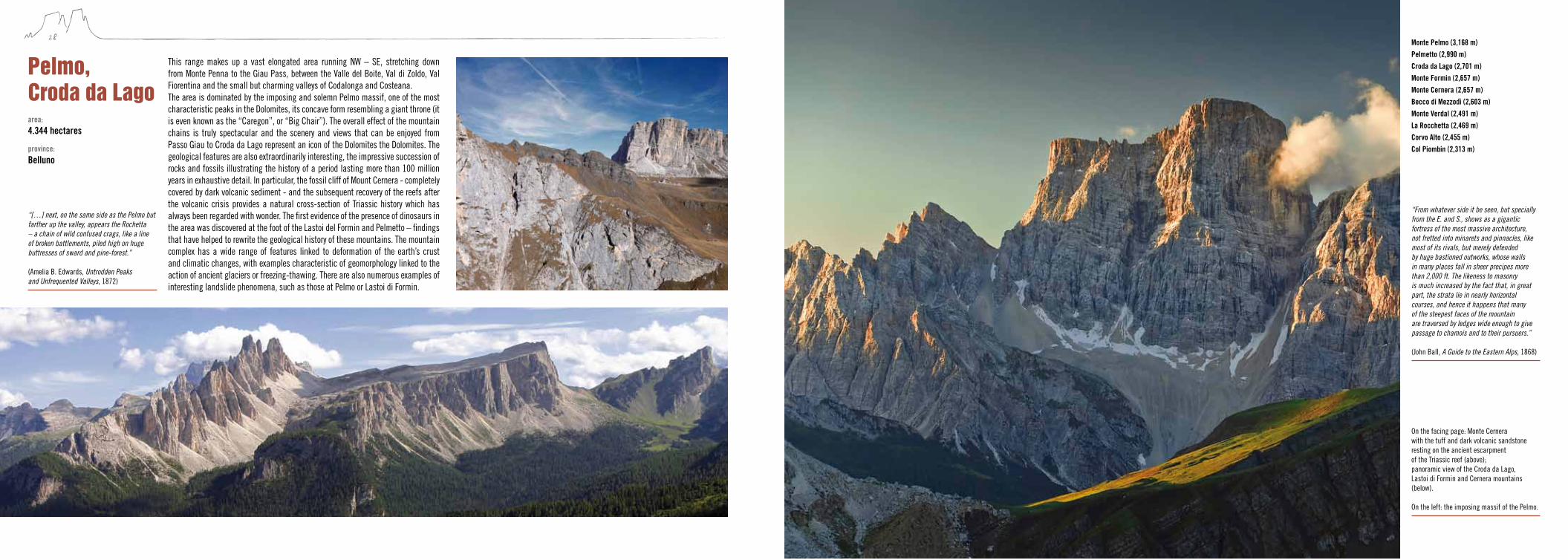
This range makes up a vast elongated area running NW – SE, stretching down from Monte Penna to the Giau Pass, between the Valle del Boite, Val di Zoldo, Val Fiorentina and the small but charming valleys of Codalonga and Costeana.The area is dominated by the imposing and solemn Pelmo massif, one of the most characteristic peaks in the Dolomites, its concave form resembling a giant throne (it is even known as the “Caregon”, or “Big Chair”). The overall effect of the mountain chains is truly spectacular and the scenery and views that can be enjoyed from Passo Giau to Croda da Lago represent an icon of the Dolomites the Dolomites. The geological features are also extraordinarily interesting, the impressive succession of rocks and fossils illustrating the history of a period lasting more than 100 million years in exhaustive detail. In particular, the fossil cliff of Mount Cernera - completely covered by dark volcanic sediment - and the subsequent recovery of the reefs after the volcanic crisis provides a natural cross-section of Triassic history which has always been regarded with wonder. The first evidence of the presence of dinosaurs in the area was discovered at the foot of the Lastoi del Formin and Pelmetto – findings that have helped to rewrite the geological history of these mountains. The mountain complex has a wide range of features linked to deformation of the earth’s crust and climatic changes, with examples characteristic of geomorphology linked to the action of ancient glaciers or freezing-thawing. There are also numerous examples of interesting landslide phenomena, such as those at Pelmo or Lastoi di Formin.
Pelmo,croda da Lago
“From whatever side it be seen, but specially from the E. and S., shows as a gigantic fortress of the most massive architecture, not fretted into minarets and pinnacles, like most of its rivals, but merely defended by huge bastioned outworks, whose walls in many places fall in sheer precipes more than 2,000 ft. The likeness to masonry is much increased by the fact that, in great part, the strata lie in nearly horizontal courses, and hence it happens that many of the steepest faces of the mountain are traversed by ledges wide enough to give passage to chamois and to their pursuers.” (John Ball, A Guide to the Eastern Alps, 1868)
“[…] next, on the same side as the Pelmo but farther up the valley, appears the Rochetta – a chain of wild confused crags, like a line of broken battlements, piled high on huge buttresses of sward and pine-forest.” (Amelia B. Edwards, Untrodden Peaks and Unfrequented Valleys, 1872)
Monte Pelmo (3,168 m)Pelmetto (2,990 m)Croda da Lago (2,701 m)Monte Formin (2,657 m)Monte Cernera (2,657 m)Becco di Mezzodì (2,603 m)Monte Verdal (2,491 m)La Rocchetta (2,469 m)Corvo Alto (2,455 m)Col Piombin (2,313 m)
area: 4.344 hectares
province: Belluno
On the facing page: Monte Cernera with the tuff and dark volcanic sandstone resting on the ancient escarpment of the Triassic reef (above); panoramic view of the Croda da Lago, Lastoi di Formin and Cernera mountains (below). On the left: the imposing massif of the Pelmo.
30 31
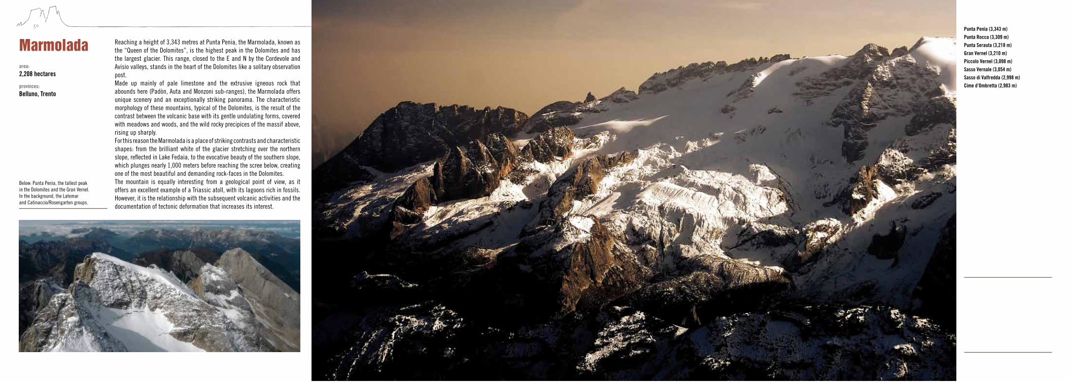
Reaching a height of 3,343 metres at Punta Penia, the Marmolada, known as the “Queen of the Dolomites”, is the highest peak in the Dolomites and has the largest glacier. This range, closed to the E and N by the Cordevole and Avisio valleys, stands in the heart of the Dolomites like a solitary observation post.Made up mainly of pale limestone and the extrusive igneous rock that abounds here (Padòn, Auta and Monzoni sub-ranges), the Marmolada offers unique scenery and an exceptionally striking panorama. The characteristic morphology of these mountains, typical of the Dolomites, is the result of the contrast between the volcanic base with its gentle undulating forms, covered with meadows and woods, and the wild rocky precipices of the massif above, rising up sharply. For this reason the Marmolada is a place of striking contrasts and characteristic shapes: from the brilliant white of the glacier stretching over the northern slope, reflected in Lake Fedaia, to the evocative beauty of the southern slope, which plunges nearly 1,000 meters before reaching the scree below, creating one of the most beautiful and demanding rock-faces in the Dolomites.The mountain is equally interesting from a geological point of view, as it offers an excellent example of a Triassic atoll, with its lagoons rich in fossils. However, it is the relationship with the subsequent volcanic activities and the documentation of tectonic deformation that increases its interest.
MarmoladaPunta Penìa (3,343 m)Punta Rocca (3,309 m)Punta Serauta (3,218 m)Gran Vernel (3,210 m)Piccolo Vernel (3,098 m)Sasso Vernale (3,054 m)Sasso di Valfredda (2,998 m)Cime d’Ombretta (2,983 m)
area:
2,208 hectares
provinces: Belluno, Trento
The presence of the largest and most southerly glacier in the Dolomites makes this range an area of particular interest in geomorphological terms and a natural testing ground documenting climate change over the last few thousand years.
“[…] the massive snow-clad Marmolata (sic), 10,400 feet high, surnamed the Queen of the Dolomites; but she is a severe and haughty queen, who knows how to hold her own, and keep intruders at a distance; and many who have been enchanted with her stern beauty from afar have rued the attempt at intruding on the cold solitude of her eternal penance.” (Rachel Harriette Busk, The Valleys of Tirol, 1874)
Below: Punta Penìa, the tallest peak in the Dolomites and the Gran Vernel. In the background, the Latemar and Catinaccio/Rosengarten groups.

32 33
This range is very extensive and includes several spectacular mountains: from south to north one can see the Vette Feltrine, the Cimonega-Erera Brendol group, the Monti del Sole, the Schiara and the Talvena, Monte Pizzocco, the Civetta and Moiazza groups, the Pale di San Martino and the Pale di San Lucano.The area is characterised by a varied landscape: from rock-faces to grasslands and alpine meadows, with rushing streams and quiet pools, glaciers and peat-bogs. This variety is linked to the structure of the area, made up of different types of rock.The southerly part of the range has a wealth of nature reserves and unspoiled
Pale di san Martino, san Lucano, Dolomiti Bellunesi, Vette Feltrine
“For this country owes its wonderful beauty in great part to the constantly recurring contrast between the tall bare cliffs of the green hills which like a sea roll their verdurous waves between them. Round the peaks lies a region of wide-spreading downs, scarcely divided from each other by low grassy ridges; of forest clad values where the rich soil nurtures a dense undergrowth of ferns and moisture-loving plants. The huge crests of the Sass Maòr or the Cimon della Pala never look so wonderful as when, seen from among the rhododendrons and between the dark spires of pine, their ‘rosy heights come out about lawns’.” (Douglas William Freshfield, The Italian Alps, 1875)
area:
31,666 hectares
provinces:
Belluno, Trento
parks:
Parco Nazionale Dolomiti Bellunesi
Parco Naturale Paneveggio-Pale di San Martino
Cima Civetta (3,220 m)Cima della Vezzana (3,192 m)Cima di Bureloni (3,130 m)Cimon della Pala (3,129 m)Pala di San Martino (2,982 m)Cima della Fradusta (2,939 m)Monte Mulaz (2,906 m)Moiazza (2,878 m)Agner (2,872 m)Sass Maor (2,814 m)Schiara (2,565 m)Talvena (2,542 m)Burel (2,281 m)
On the facing page: the imposing walls of the Schiara (above) and the Civetta (below), which recount, layer after layer, the passage from the Triassic to the Jurassic and the fragmentation of the great tidal plain of Dolomitic bedrock. On the left: the Cimon della Pala.
landscapes, often rugged and inaccessible, deep-cut valleys and steep rock-faces. To the north the landscape is more broken and the shape of the mountain range is linked to the presence of one of the largest and most intact fossil cliffs from the Triassic age. From the Coldai to Pelsa, via the Agner, Pale di San Lucano and Pale di San Martino it is possible to walk – literally - over the atolls of an ancient lagoon that rose up a thousand meters from the seabed.There are also fascinating colour contrasts, as can be seen in the Val di Gares or San Lucano, as a result of the dark volcanic rock resting on the white banks of the atoll. Above the massive reefs, over the ancient lagoons - now plateaus - there are piles of other rocks forming new mountains and new stories. The tightly layered face of the Civetta, broken up into innumerable needles and pinnacles, testifies to the extraordinary geological history of these peaks. One can only realise the considerable importance of these mountains for geology by considering the variety of phenomena represented here. The south illustrates the “recent” history of the Upper Triassic through to the Cretaceous, documenting the events that led to the Dolomites sinking deep into the sea, while the history of the reefs and volcanoes dominates to the north. The Fradusta plateau on the Pale di San Martino is unique in terms of its altitude and dimensions. It represents an original surface of the reef, laid bare by the erosion of more recent formations.The geomorphological features are particularly significant, including karst and glacio-karstic phenomena with various epigean and hypogean forms, as well as glacial modelling, with a series of mainly late-glacial moraine deposits and water erosion, with deep gorges and ravines.
34 35
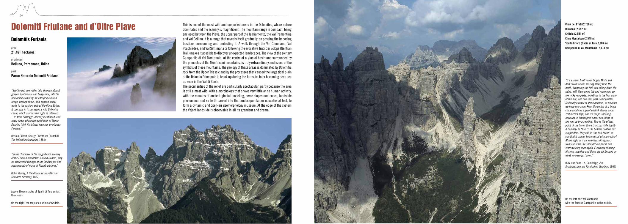
This is one of the most wild and unspoiled areas in the Dolomites, where nature dominates and the scenery is magnificent. The mountain range is compact, being enclosed between the Piave, the upper part of the Tagliamento, the Val Tramontina and Val Cellina. It is a range that reveals itself gradually, on passing the imposing bastions surrounding and protecting it. A walk through the Val Cimoliana, Val Poschiadea, and Val Settimana or following the evocative Truoi dai Sclops (Gentian Trail) makes it possible to discover unexpected landscapes. The view of the solitary Campanile di Val Montanaia, at the centre of a glacial basin and surrounded by the pinnacles of the Monfalconi mountains, is truly extraordinary and is one of the symbols of these mountains. The geology of these areas is dominated by Dolomitic rock from the Upper Triassic and by the processes that caused the large tidal plain of the Dolomia Principale to break up during the Jurassic, later becoming deep sea as seen in the Val di Suola.The peculiarities of the relief are particularly spectacular, partly because the area is still almost wild, with a morphology that shows very little or no human activity, with the remains of ancient glacial modeling, scree slopes and cones, landslide phenomena and so forth carved into the landscape like an educational tool, to form a dynamic and open-air geomorphology museum. At the edge of the system the Vajont landslide is observable in all its grandeur and drama.
Dolomiti Friulane and d’oltre PiaveDolomitis Furlanis
“Southwards the valley falls through abrupt gorges, by Perarolo and Longarone, into the rich Belluno country. An abrupt mountain range, peaked above, and wooded below, walls in the eastern side of the Piave Valley. It conceals in its recesses a wild Dolomitic chain, which startles the sight at intervals – as from Domegge, already mentioned, and lower down, where the weird form of Monte Duraino (sic), its loftiest member, overhangs Perarolo.” (Josiah Gilbert, George Cheetham Churchill, The Dolomite Mountains, 1864)
area: 21,461 hectares
provinces: Belluno, Pordenone, Udine
park: Parco Naturale Dolomiti Friulane
“In the character of the magnificent scenery of the Friulian mountains around Cadore, may be discovered the type of the landscapes and backgrounds of many of Titian’s pictures.” (John Murray, A Handbook for Travellers in Southern Germany, 1837)
Cima dei Preti (2,706 m)Duranno (2,652 m)Cridola (2,581 m)Cima Monfalcon (2,548 m)Spalti di Toro (Cadin di Toro 2,386 m) Campanile di Val Montanaia (2,173 m)
“It’s a vision I will never forget! Mists and dark storm clouds moving slowly from the north, bypassing the fork and rolling down the ridge, with them come life and movement on the rocky ramparts, indistinct in the first glare of the sun, and one sees peaks and profiles. Suddenly a tower of stone appears, as no other we have ever seen. From the center of a lonely circle suddenly a giant obelisk stands about 200 metres high, and its shape, tapering upwards, is interrupted about two thirds of the way up by a swelling. This is the widest point of the tower. There is no possible doubt; it can only be “him”! The bearers confirm our supposition. They call it “the bell-tower” so can that it cannot be confused with any other! At the sight of it all weariness disappears from our team, we shoulder our packs and start walking once again. Everybody chasing his own thoughts and these are all focused on what we have just seen.” (K.G. von Saar – K. Doménigg, Zur Erschliessung der Karnischen Voralpen, 1907)
Above: the pinnacles of Spalti di Toro amidst the clouds. On the right: the majestic outline of Cridola.
On the left: the Val Montanaia with the famous Campanile in the middle.

36 37
The Northern Dolomites is the name given to the largest of the nine areas making up the Dolomites heritage site. They include some of the most famous mountain ranges in the Alps: the Dolomiti di Sesto/Sextner Dolomiten, the Cadini, Braies/Prags, Fanes and Senes/Sennes mountains, the Croda Rossa/Hohe Gaisl, the Tofane, Monte Cristallo, Antelao, Sorapis and the Marmarole. The entire complex is bounded by the mountainous south tyrolean valleys of Pusteria/Pustertal, Sesto/Sexten, Badia/Gadertal, San Cassiano/St. Kassian and by the Ampezzo and Cadore valleys of the Rivers Boite and Piave, while the Valle d’Ansiei cuts in from the east between the Marmarole and Cadini groups like a wedge.It is a varied range, broken up by peaks, plateaus and lakes, set like jewels into the rocks and the woods. It also offers a succession of extraordinarily evocative and fantastic landscapes that have given rise to ancient legends and whose beauty cannot leave one untouched.In geological terms, the Dolomiti Settentrionali/Nördliche Dolomiten offer the most complete stratigraphic sequence found in the Dolomites, from metamorphic bedrock, dating back to an old mountain range flattened at the beginning of the Permian, up to the most recent Oligo-Miocene outcrop (about 30 million years ago) of Monte Parei. The succession of different environments characterising the geological history of the Dolomites is extraordinary, from the deserts of the Permian era to the tropical reefs and seabed of the Triassic, the lagoons and beaches of the Jurassic and the unfathomable depths of the Cretaceous. The documentation of the geological past is also illustrated at some of the most important fossil sites in the world. The plant deposits from the Anisian beds of Braies/Prags fossils from the San Cassiano/St. Kassian
Dolomiti settentrionali nördliche Dolomiten
Formation, the coral of the Alpe di Specie, the oldest amber in the Mesozoic, the megalodons in the Dolomia Principale, the aberrant ammonites of the Puez marls or the bears on the Conturines are just some examples of the extraordinary palaeontological wealth of these mountains. The geological phenomena that have made the marine rock of the Dolomites into mountains can bee seen in the folds, faults and corrugations characterising these areas.In this vast dolomite system one can see a wide range of geomorphological processes: from phenomena linked to deformation of the earth’s crust, as demonstrated by high energy of the relief and from a series of fault scarps, morphoclimatic ones, bearing many signs of ancient modeling by ice, karstic ones, on plateaus above Ampezzo, as well as morphodynamic ones, some ongoing, with several examples of landslide phenomena.
“[…]and the extraordinary towers of the Drei Zinnen come one after the other into view. As for the Drei Zinnen, they surpass in boldness and weirdness all the Dolomites of the Ampezzo. Seen through an opening between two wooded hills, they rise abruptly from behind the intervening plateau of Monte Piana, as if thrust up from the centre of the earth, like a pair of tusks. No mere description can convey to even the most apprehensive reader, any correct impression of their outline, their look of intense energy, of upwardness, of bristling, irresistible force.” (Amelia B. Edwards, Untrodden Peaks and Unfrequented Valleys, 1872)
area:
53,586 hectares
provinces: Belluno, Bolzano/Bozen - South Tyrol
parks: Parco Naturale Fanes-Senes-Braies/ Naturpark Fanes-Sennes-Prags
Parco Naturale Tre Cime/ Naturpark Drei Zinnen
Parco Naturale Dolomiti d’Ampezzo
Antelao (3,264 m)
Tofana di Mezzo (3,244 m)
Tofana de Inze (3,238 m)
Tofana di Rozes (3,225 m)
Cristallo (3,221 m)
Sorapis (3,205 m)
Ounta Tre Scarperi/Dreischusterspitze (3,152 m)
Croda Rossa/Hohe Gaisl (3,146 m)
Croda dei Toni/Zwölfer Kofel (3,094 m)
Cima Undici/ Elfer Spitze (3,092 m)
Tre Cime di Lavaredo/Drei Zinnen (Cima Grande/Große Zinne) (2,999 m)
Marmarole (2,932 m)
Cadini di Misurina (2,839 m)
In the centre: view of the southern face of the Tre Cime di Lavaredo/Drei Zinnen. On the right: Gran Fanes/Groß Fanes. On the facing page: the unmistakeable pyramid form of the Antelao.

38 39
This range is relatively compact. It is bordered to the S by the Val Gardena/Grödnertal, to the E by the Val Badia/Gadertal and to the N by the beautiful and unspoilt Val di Funes/Villnösstal.The area is characterised by two types of landscape, representing the typical images of the Dolomites: the northern area is dominated by two massifs standing alongside each other, Odle d’Eores/Aferer Geisler with the Sass de Putia/Peitler Kofel and the Odle di Funes/Villnösser Geisler with the Sas Rigais, documenting the original isolated reefs, which have now become jagged crests and imposing monoliths of Dolomitic rock. The southern area (Gardenaccia), is instead occupied by the vast karst plateau at an altitude of around 2,500 metres surrounding the Col de Puez/Puezspitze, adorned with meadows and magnificent alpine lakes. Above this plateau, characterised by grey rocks in an almost lunar landscape, there are the pyramids of dark rock, such as the Col de la Soné, which add further interest to a range which already has a wealth of unique characteristics in terms of landscape and geology. The geological aspects are
Puez-odlePuez-GeislerPöz-odles
unusual: the geological succession is among the most complete in the Dolomites and tectonic deformation is very slight. The period dominated by tropical atolls and reefs is fully documented, while later events relating to the period of sinking that took place during the Jurassic and Cretaceous, leading to these areas becoming pelagic seamounts, are easily visible and clear.The forms of relief are particularly related to structural features: a high energy of the relief in the northern sector and limestone plateau morphology in the southern one. There are many morphoclimatic vestiges, generated by the glaciers, together with evidence of landslides dating back several thousand years ago and still active today.
Sas Rigais (3,025 m)Sas de Putia/Peitlerkofel (2,875 m)Col de Puez/Puezspitze (2,725 m)Sassongher (2,665 m)Col de la Soné (2,634 m)
area:
7,930 hectares
province: Bolzano/Bozen - South Tyrol
park: Parco Naturale Puez-Odle/ Naturpark Puez-Geisler
“O the mind, mind has mountains; cliffs of fall Frightful, sheer, no-man-fathomed. Hold them cheap May who ne’er hung there.” (Gerard M. Hopkins, No worst, there is none, 1885)
“Come closer please, examine this spectacle which is without a shadow of doubt one of the most beautiful, powerful and extraordinary things that this planet has to offer. […] Are they rocks or clouds? Are they real or is it a dream?” (Dino Buzzati, Le montagne di vetro, 1956)
On the facing page: the Sass Rigais provides a cross-section of the geological history of these mountains, which goes from the arid plains and lagoons of the Permian era to the tropical reefs of the Middle Triassic (on the left). The karst tableland of the Gardenaccia, with the characteristic Col de la Soné, made up of Puez marls from the Cretaceous period (on the right). On the left: the peaks of the Odle/Geisler amidst the clouds.
40 41
This mountain range is one of the most extensive and evocative in the Dolomites, characterised not so much by mighty massifs, as by a magnificent combination of sharp pointed peaks and vast rock faces, illuminated by the iridescent pink and reddish light of the setting sun and by magnificent lakes reflecting the surrounding peaks. The particularly spectacular landscape is characterised by extremely distinctive mountains, whose profiles are recognised throughout the world, such as the Torri del Vajolet/Vajolettürme, Campanili del Latemar and Sciliar/Schlern. Catinaccio/Rosengarten and Sciliar/Schlern are rocky ridges facing N-W over a terrace overlooking the Tires/Tiers and Isarco/Eisack valleys, bounded to the south by the Val di Fassa and the Val Duron. Depending on the viewpoint, the mountains change their appearance radically, while maintaining a distinctive profile. For example, when seen from Bolzano/Bozen the Sciliar/Schlern looks like a giant monolith with a flat roof, from which two separate pinnacles emerge, the Santner and Euringer peaks, becoming one of the emblems of South Tyrol. However, when viewed from the Alpe di Siusi/Seiser Alm, a gigantic scarp is evident, joining the pastures at the same angle at which the atoll was once linked to the sea bed. The Catinaccio-Rosengarten has the form of an endless series of peaks and sharp needles radiating from the Torri del Vajolet/Vajolettürme, illustrating the movement of an island towards the sea 240 million years ago.Another spectacular feature is the constant change in colour as the day progresses – from pink to red and then purple towards the evening – which has given rise to many legends and helped make this mountain the kingdom of King Laurin. The Latemar, on the other hand, stands isolated between the Val di Fiemme in Trentino and the Val d’Ega/Eggental in South Tyrol. There is an extraordinary view of this range from Passo Costalunga/Karerpass, where the lone peak, with the horizontal lines of the lagoon sediment and the sloping profile of the scarp reflected in the waters of Lake Carezza/Karersee.While the landscape is magnificent, the purely geological features are absolutely fascinating. The accessibility of the outcrops, the large quantity of fossils and the relationship between volcanic and carbonate sediment make these mountains one of the most important areas in the world for study and reference regarding the stratigraphy of the Triassic.The system is characterized by significant morphological geodiversity: significant energy of the relief, a great variety of structural forms of a tectonic and lithological type, numerous elements of palaeoclimatic evidence both glacial and pre-glacial, as well as a wide range of morphodynamic elements of a gravitational type.
sciliar-catinaccio/schlern-Rosengarten,Latemarsciliar-ciadenac, Latemar
“Imagine a gigantic amphitheatre or jagged, cleft precipices, shooting 3,000 feet above the spectator out of a depth far below him, and reaching, in the Rothewand Spitze, to the height of 10,200 feet above the sea. Let the arms of this amphitheatre stretch forwards so as to embrace nearly one half of his horizon, shutting him up to the one view of a stern, desolate, barren face, that present itself on all sides. Let successive masses of débris descend from the base of this long line of precipices through the whole sweep of its circuit, and threaten to occupy the entire basin below, while still leaving a small patch of bright green pasture, on which a dark spot is identified as a châlet. All this imagined will still give but a very inadequate idea of the impressiveness of the scene.” (Josiah Gilbert, George Cheetham Churchill, The Dolomite Mountains, 1864)
“Looking backwards through an opening at one of these dark corners, we saw again the Latemar precipices, which we had lost sight of since leaving Welschenhofen. They stood high in air, and bathed in sunlight, their front worn into singular resemblance to the pipes of a gigantic organ.” (Josiah Gilbert, George Cheetham Churchill, The Dolomite Mountains, 1864).
area: 9,302 hectares
provinces: Bolzano/Bozen - South Tyrol, Trento
park: Parco Naturale Sciliar-Catinaccio/ Naturpark Schlern-Rosengarten
Catinaccio d’Antermoia/Antermoi (3,002 Meter)Catinaccio/Rosengarten/Ciadenac (2,981 Meter)Cima Scalieret (2,887 Meter)Croda di Lausa (2,876 Meter)Campanili del Latemar (2,842 Meter)Cima Val Bona (2,822 Meter)Molignon (2,820 Meter)Torri del Vajolet/Vajolettürme (2,813 Meter)Roda di Vael/Rotwand (2,806 Meter)Corno d’Ega/Eggentaler Horn (2,799 Meter)Schenon (2,791 Meter)Cima di Terrarossa/Roterdspitz (2,580 Meter)Punta Santner/Santner Spitze (2,413 Meter)
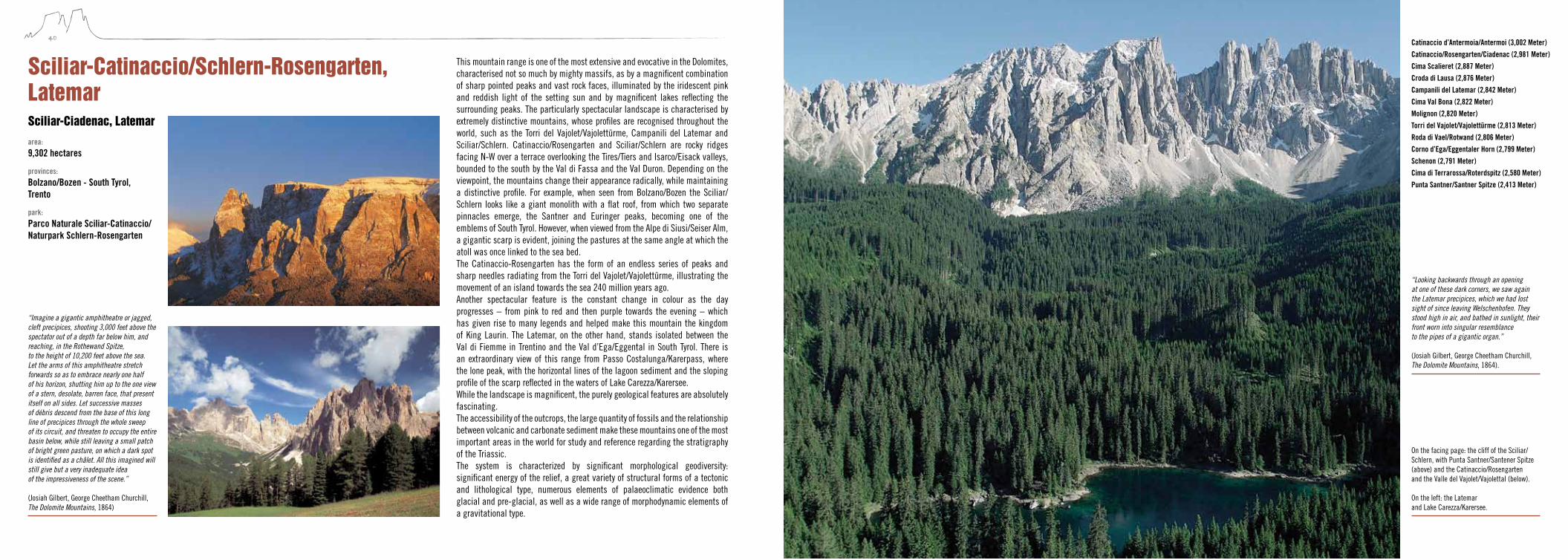
On the facing page: the cliff of the Sciliar/Schlern, with Punta Santner/Santener Spitze (above) and the Catinaccio/Rosengarten and the Valle del Vajolet/Vajolettal (below). On the left: the Latemar and Lake Carezza/Karersee.
42 43
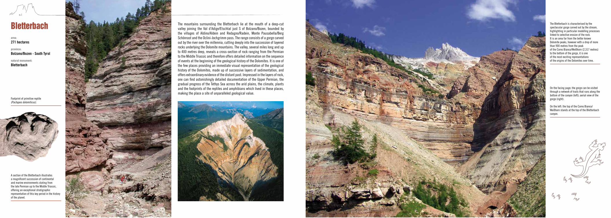
The mountains surrounding the Bletterbach lie at the mouth of a deep-cut valley joining the Val d’Adige/Etschtal just S of Bolzano/Bozen, bounded by the villages of Aldino/Aldein and Redagno/Radein, Monte Pausabella/Berg Schönrast and the Oclini-Jochgrimm pass. The range consists of a gorge carved out by the river over the millennia, cutting deeply into the succession of layered rocks underlying the Dolomite mountains. The valley, several miles long and up to 400 metres deep, reveals a cross-section of rock ranging from the Permian to the Middle Triassic and therefore offers detailed information on the sequence of events at the beginning of the geological history of the Dolomites. It is one of the few places providing an immediate visual representation of the geological history of the Dolomites, made up of successive layers of sedimentation, and offers extraordinary evidence of the distant past. Impressed in the layers of rock, one can find astonishingly detailed documentation of the Upper Permian, the gradual progress of the Tethys Sea across the arid plains, the climate, plants and the footprints of the reptiles and amphibians which lived in these places, making the place a site of unparalleled geological value.
Bletterbach
A section of the Bletterbach illustrates a magnificent succession of continental and marine environments stating from the late Permian up to the Middle Triassic, offering an exceptional stratigraphic representation of this key period in the history of the planet.
The Bletterbach is characterised by the spectacular gorge carved out by the stream, highlighting in particular modelling processes linked to selective erosion of the rock. It is an area far from the better known Dolomite peaks, however with a drop of more than 900 metres from the peak of the Corno Bianco/Weißhorn (2,317 metres) to the bottom of the gorge, it is one of the most exciting representations of the origins of the Dolomites over time.
area: 271 hectares
province: Bolzano/Bozen - South Tyrol
natural monument: Bletterbach
Footprint of primitive reptile (Pachypes dolomiticus).
On the facing page: the gorge can be visited through a network of trails that runs along the bottom of the canyon (left); aerial view of the gorge (right). On the left: the top of the Corno Bianco/Weißhorn stands at the top of the Bletterbach canyon.

44 45
The Brenta Dolomites lie to the west of the River Adige in the westernmost part of the Dolomites and take the form of an island of dolomite rock, bounded to the west by the Giudicarie fault, a massive tectonic line marking the separation between the carbonate platform and the intrusive Adamello and Presanella mountain ranges. The range runs N-S for around 40 kilometres and is 12 kilometres wide from E to W. Unlike other Dolomite ranges marked by their slender lines and plasticity, this magnificent ridge of calcareous rock and dolomite has majestic and austere forms, with rock faces culminating in peaks and sharp angles of differing shapes and sizes. The Campanil Basso is a pinnacle which has always proved particularly popular with generations of mountaineers and mountain enthusiasts. Selective erosion has shaped the massive banks of dolomitic bedrock, carving out this slender pinnacle nestling in the heart of the Brenta
Dolomiti di Brenta
mountains, opposite the Cima Tosa and the Campanil Alto, at the top of the Brenta valley. From the geological point of view, this mountain range documents the long and complex history from the Permian to the Jurassic. Evidence of Norian-Liassic succession is particularly well-preserved, here presenting unusual features and illustrating the transition from what is known as the Trento Plateau to the Lombard Basin. Every phase in the structural evolution and stratigraphy of this period of time is clearly outlined, as are the spectacular tectonic features.In particular, from geomorphological point of view, the system presents three emblematic situations of geomorphodiversity: a wide range of landforms related to the tectonic features at both a medium and large scale, well-developed articulated karst, with epigean and hypogean forms, as well as exemplary morphoclimatic evidence case studies, both relict and active.
“In several of the preceding routes, reference has been made to a considerable mountain-mass, extending on the E. side of Val Rendena, for which the collective name Brenta Alta is here adopted. It is composed of a brittle dolomitic limestone […], which by exposure to the weather assumes various tints, from pale grey to rich pink and murky red. By its extraordinary boldness and singularity of form, this range fascinates all mountaineers who approach it, yet it is but very lately that it has been even partially explored. It may best be described as an irregular group of towers of rock, varying in height from 9,500 to nearly 11,000 ft., that rise out of a huge broken mass of limestone, which is penetrated in some directions by deep valleys and recesses. As a general rule, the towers are isolated, showing on one or more sides absolutely vertical faces of rock, and each is capped by a covering of névé (sic).” (John Ball, The Alpine Guide, 1866)
area: 11,135 hectares
province: Trento
parks: Parco Naturale Adamello-Brenta (UNESCO Geopark Adamello Brenta)
Cima Tosa (3,173 m)Cima Brenta (3,150 m)Crozzon di Brenta (3,118 m)Cima Vallesinella (3,114 m)Cima d’Ambiez (3,102 m)Cima Mandron (3,040 m)Spallone dei Massodi (2,999 m)Cima Falkner (2,999 m)Cima Vallon (2,968 m)Cima Brenta Alta (2,960 m)Cima Agola (2,959 m)Cima d’Armi (2,951 m)Campanile di Brenta (2,937 m)Campanil Basso (2,883 m)
Above: Crozzon di Brenta. On the right: Cima Tosa and central part of Brenta chain. On the facing page: Torre di Brenta and Campanil Basso.
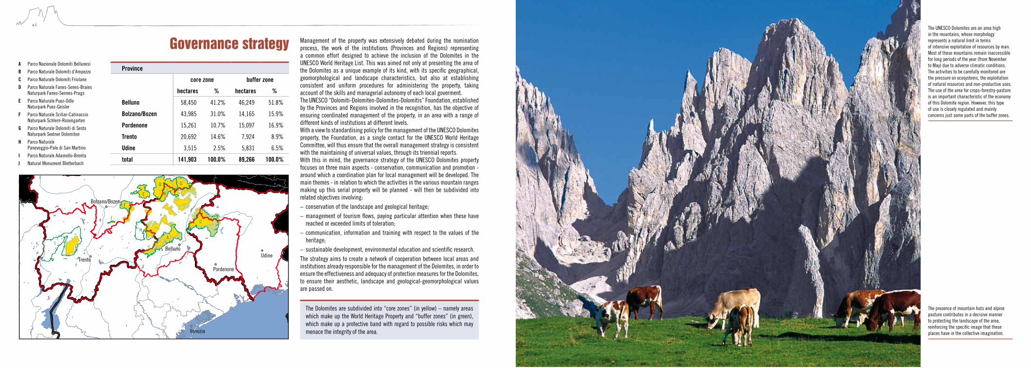
46 47
Management of the property was extensively debated during the nomination process, the work of the institutions (Provinces and Regions) representing a common effort designed to achieve the inclusion of the Dolomites in the UNESCO World Heritage List. This was aimed not only at presenting the area of the Dolomites as a unique example of its kind, with its specific geographical, geomorphological and landscape characteristics, but also at establishing consistent and uniform procedures for administering the property, taking account of the skills and managerial autonomy of each local goverment.The UNESCO “Dolomiti-Dolomiten-Dolomites-Dolomitis” Foundation, established by the Provinces and Regions involved in the recognition, has the objective of ensuring coordinated management of the property, in an area with a range of different kinds of institutions at different levels.With a view to standardising policy for the management of the UNESCO Dolomites property, the Foundation, as a single contact for the UNESCO World Heritage Committee, will thus ensure that the overall management strategy is consistent with the maintaining of universal values, through its triennial reports.With this in mind, the governance strategy of the UNESCO Dolomites property focuses on three main aspects - conservation, communication and promotion - around which a coordination plan for local management will be developed. The main themes - in relation to which the activities in the various mountain ranges making up this serial property will be planned - will then be subdivided into related objectives involving:– conservation of the landscape and geological heritage;– management of tourism flows, paying particular attention when these have
reached or exceeded limits of toleration;– communication, information and training with respect to the values of the
heritage;– sustainable development, environmental education and scientific research.The strategy aims to create a network of cooperation between local areas and institutions already responsible for the management of the Dolomites, in order to ensure the effectiveness and adequacy of protection measures for the Dolomites, to ensure their aesthetic, landscape and geological-geomorphological values are passed on.
Governance strategy
Venezia
UdineTrento
Pordenone
Bolzano/Bozen
Belluno
A
B
C
D
E
F
G
H
I
J
Province
core zone buffer zone
hectares % hectares %
Belluno 58,450 41.2% 46,249 51.8%
Bolzano/Bozen 43,985 31.0% 14,165 15.9%
Pordenone 15,261 10.7% 15,097 16.9%
Trento 20,692 14.6% 7,924 8.9%
Udine 3,515 2.5% 5,831 6.5%
total 141,903 100.0% 89,266 100.0%
The UNESCO Dolomites are an area high in the mountains, whose morphology represents a natural limit in terms of intensive exploitation of resources by man. Most of these mountains remain inaccessible for long periods of the year (from November to May) due to adverse climatic conditions. The activities to be carefully monitored are the pressure on ecosystems, the exploitation of natural resources and non-productive uses. The use of the area for crops-forestry-pasture is an important characteristic of the economy of this Dolomite region. However, this type of use is closely regulated and mainly concerns just some parts of the buffer zones.
The Dolomites are subdivided into “core zones” (in yellow) – namely areas which make up the World Heritage Property and “buffer zones” (in green), which make up a protective band with regard to possible risks which may menace the integrity of the area.
A Parco Nazionale Dolomiti Bellunesi
B Parco Naturale Dolomiti d’Ampezzo
C Parco Naturale Dolomiti Friulane
D Parco Naturale Fanes-Senes-Braies Naturpark Fanes-Sennes-Prags
E Parco Naturale Puez-Odle Naturpark Puez-Geisler
F Parco Naturale Sciliar-Catinaccio Naturpark Schlern-Rosengarten
G Parco Naturale Dolomiti di Sesto Naturpark Sextner Dolomiten
H Parco Naturale Paneveggio-Pale di San Martino
I Parco Naturale Adamello-Brenta
J Natural Monument Bletterbach
The presence of mountain huts and alpine pasture contributes in a decisive manner to protecting the landscape of the area, reinforcing the specific image that these places have in the collective imagination.
48
www.dolomiti-unesco.org http://whc.unesco.org/
Photo credits
Geoparc Bletterbach Archives, pp. 42 left, 43; Parco Naturale Adamello-Brenta Archives, pp. 8 middle, 17, 44 left; Parco Naturale Dolomiti Friulane Archives, p. 8 down; Presidenza Repubblica Italiana Archives, p. 5 right down; Geological Survey Archives - Autonomous Province of Bolzano/Bozen South Tyrol, p. 25 right top; Natural Park Office Archives - Autonomous Province of Bolzano/Bozen South Tyrol, pp. 5 top, 12 down, 36 down, 38 right; Dario Bellodis, p. 20 right top; Marco Benedetti, p. 45; Nicola Bombassei, pp. 2-3, 11 down, 16 top; Tony Camerano, p. 19; Piero Cavagna, p. 11 top; Elio Ciol, p. 35; Stefano Dal Molin, pp. 8 top, 13, 21, 23 middle top, 24, 34 top; Michele Da Pozzo, pp. 13 down; Stefano Da Rin Puppel, pp. 30-31; Manrico Dell’Agnola pp. 28 down, 32 down, 34 down; Flavio Faganello, p. 12 top; Franco Fiamoi, p.15; Diego Gaspari Bandion, pp. 4, 9, 29, 37, 36-37; Piero Gianolla, pp. 8 background, 23 right top, 28 top, 32 top; Danilo Giordano, pp. 23 left top, 25 left top; Pietro Lattuada, p. 40 down; Volkmar Mair , Geological Sur-vey - Autonomous Province of Bolzano/Bozen South Tyrol, p. 20 left down; Cesare Micheletti, p. 48; Valentino Pais Tarsilia, p. 6 left; Mario Panizza, p. 25 middle top; Hans Pescoller, Natural Park Office - Autonomous Province of Bolzano/Bozen South Tyrol, p. 39; Martin Price, pp. 22 middle top, 22 right top, 30 down; Renato Sascor, Natural Park Office - Autonomous Province of Bolzano/Bozen South Tyrol, p. 16 down; Südtirol Marketing/Clemens Zahn, p. 6-7; Südtirol Marketing/Frieder Blickle, p. 40 top; Georg Tappeiner, pp. 10 down, 22 left top, 26-27, 38 left, 41, 42 middle, 42 right; Ugo Visciani, p. 33; Roberto Zanette, p. 5 left down; Gianni Zotta, p. 44 right.
Edited by Cesare MichelettiScientific contributions Piero Gianolla, geology; Cesare Micheletti, landscape; Mario Panizza, geomorphology; Loredana Ponticelli, aesthetics and literature
Translations The Office, Trieste; Vivienne Frankell, Verona
Layout design ArtimediaMaps and figures A2 studio (p.10 top, p.18, p.46); Stefano Furin (p.20 right down, pp.22-23)
Cover Concept: A2 studio front cover: Sasso della Croce/Sas dla Crusc/Heiligkreuzkofel (Georg Tappeiner)
back cover: from left to right: Pelmo (Stefano Dal Molin); Cridola (David Cappellari); Campanile di Val Montanaia (Luca Tonegutti) Torri del Vajolet/Vajolettürme (Ugo Visciani); Tre Cime di Lavaredo/Drei Zinnen (Georg Tappeiner);
flap: Franz Dantone, Traveller and Alpine guides at Santner Pass, 1870 (coll. Bepi Pellegrinon, Falcade)
inside cover: thematic maps of the Dolomites World Heritage property (Stefano Furin)
Contacts and information- Provincia di Belluno Ufficio UNESCO [email protected] Provincia autonoma di Bolzano-Alto Adige Autonome Provinz Bozen-Südtirol Ufficio Parchi naturali - Amt für Naturparke [email protected] Provincia di Pordenone Territorial Planning and Dolomites UNESCO Service [email protected] Provincia autonoma di Trento Dipartimento Urbanistica e Ambiente [email protected] Provincia di Udine Servizi Sviluppo Area Montagna e supporto “Fondazione Dolomiti” [email protected] Regione Autonoma Friuli Venezia Giulia Servizio beni ed attività culturali [email protected] Regione del Veneto Servizio Reti Ecologiche e Biodiversità [email protected]
© 2010 All rights reserved
Provincia di Belluno Provincia Autonoma di Bolzano-Alto Adige/ Autonome Provinz Bozen-Südtirol Provincia di Pordenone Provincia autonoma di Trento Provincia di Udine Regione Autonoma Friuli Venezia Giulia Regione del Veneto
1st reprint 2011
Tel. 0436 867395 0436 870062
Fax: 0436 876556email: [email protected]
Foundation Dolomites UNESCO