“the birds case” - national parks and wildlife service case pom may... · the timeline of the...
TRANSCRIPT
Judgment of the Court of Justice of the European Union in
Case C 418/04 Commission v Ireland
“The Birds Case”
Update – May 2017
A Programme of measures by Ireland to ensure full compliance with the Judgment of the Court of Justice
of the European Union
2
CONTENTS Summary
Background – The Birds Directive
The case against Ireland – what is it about
Ireland’s response to the Judgement Sections Response to the specific findings against Ireland
1. Inadequate Number and size of areas classified as SPAs, contrary to Article 4 (1) and (2) of the Birds Directive
2. Failure to apply the first sentence of Article 4(4) of the Birds Directive to the
areas that should have been classified as SPAs
3. Failure to transpose and apply the second sentence of Article 4(4) of the Birds Directive
4. Inadequate transposition and application of Article 6(2)-(4) of the Habitats
Directive
5. Failure to transpose Article 10 of the Birds Directive. Obligation on Minister to encourage research
Appendices
Appendix 1 – List of Ireland’s Classified SPAs
Appendix 2 – List of Ireland’s Designated SPAs
Appendix 3 - Ringabella Estuary, Co Cork and its potential inclusion into the SPA Network
Appendix 4 – Action Plan on outstanding issues
Appendix 5 - Management of Fisheries and Aquaculture Activities in Natura 2000 sites in Ireland - Progress update, December 2013
Appendix 6 - Fisheries Programme of Measures: Additional Information July 2015
3
SUMMARY Background – The Birds Directive
Directive 2009/147/EC of the European Parliament and of the Council of 30 November 2009 on the conservation of wild birds (this is the codified version of Directive 79/409/EC as amended) is the EU’s oldest piece of nature legislation and one of the most important, creating a comprehensive scheme of protection for all wild bird species naturally occurring in the Union. It was adopted unanimously by the Members States in 1979 as a response to increasing concern about the declines in Europe's wild bird populations resulting from pollution, loss of habitats as well as unsustainable use. It was also in recognition that wild birds, many of which are migratory, are a shared heritage of the Member States and that their effective conservation required international co-operation.
The directive recognises that habitat loss and degradation are the most serious threats to the conservation of wild birds. It therefore places great emphasis on the protection of habitats for endangered as well as migratory species (listed in Annex I), especially through the establishment of a coherent network of Special Protection Areas (SPAs) comprising all the most suitable territories for these species. Since 1994 all SPAs form an integral part of the NATURA 2000 ecological network.
The Birds Directive bans activities that directly threaten birds, such as the deliberate killing or capture of birds, the destruction of their nests and taking of their eggs, and associated activities such as trading in live or dead birds, with a few exceptions (listed in Annex III - III/1 allows taking in all Member States; III/2 allows taking in Member States in agreement with European Commission). The Directive recognises hunting as a legitimate activity and provides a comprehensive system for the management of hunting (limited to species listed in Annex II - II/1 allows hunting in all Member States; II/2 allows hunting in listed Member States) to ensure that this practice is sustainable. This includes a requirement to ensure that birds are not hunted during the periods of their greatest vulnerability, such as the return migration to the nesting areas, reproduction and the raising of chicks. It requires Member States to outlaw all forms of non-selective and large scale killing of birds, (especially the methods listed in Annex IV). It promotes research to underpin the protection, management and use of all species of birds covered by the Directive (Annex V).
The case against Ireland – what it is all about
In December 2007, the Court of Justice of the European Union1, arising from a case
brought by the European Commission, delivered judgment on Ireland's
1 Previously referred to as the European Court of Justice

4
implementation of the Birds Directive. The Judgment refers to six separate
complaints and gives a ruling in respect of each one. The Court found in favour of
Ireland in respect of one complaint.
In broad terms the Court found that Ireland:
had not correctly transposed the Directive in a number of areas, including in
relation to assessment of land use plans,
had not designated a sufficient number of Special Protection Areas in respect of
particular species, e.g. corncrake, kingfisher,
had not designated SPAs in accordance with the required standard of
protection,
did not meet the required standard regarding the level of protection being
achieved in SPAs or in areas that should be designated as SPAs, as set out in
Article 4 of the Birds Directive or Article 6 of the Habitats Directive, in particular
by failing to take all reasonable measures, including targeted action to prevent
their deterioration, and by not requiring appropriate assessment for certain
types of activities including aquaculture, and
required protective measures outside SPAs have not been put in place.
The Timeline of the Birds Case Judgment Case Document Date Name of the parties
C-418/04 Application (OJ) 08/01/2005 Commission v Ireland See: http://eur-lex.europa.eu/LexUriServ/LexUriServ.do?uri=OJ%3AC%3A2005%3A006%3A0022%3A0022%3Aen%3APDF
C-418/04 Order 17/03/2005 Commission v Ireland See: http://curia.europa.eu/juris/document/document.jsf?text=&docid=59931&pageIndex=0&doclang=en&mode=req&dir=&occ=first&part=1&cid=3100578
C-418/04 Opinion 14/09/2006 Commission v Ireland See: http://curia.europa.eu/juris/showPdf.jsf?text=&docid=64070&pageIndex=0&doclang=en&mode=req&dir=&occ=first&part=1&cid=3100578
C-418/04 Judgment 13/12/2007 Commission v Ireland
See: http://curia.europa.eu/juris/showPdf.jsf?text=&docid=71717&pageIndex=0&doclang=en&mode=req&dir=&occ=first&part=1&cid=3101025

5
C-418/04 Judgment (OJ) 23/02/2008 Commission v Ireland See: http://curia.europa.eu/juris/showPdf.jsf?text=&docid=72029&pageIndex=0&doclang=en&mode=req&d
ir=&occ=first&part=1&cid=3101367
Purpose of this Document The Programme of Measures sets out the actions taken to date by Ireland in response to the Judgment of the Court together with commitments for further action to ensure that remaining issues have been dealt with. It is updated at 6-monthly intervals. Copies of all correspondence on the case and any general queries may be directed or obtained from Frank Donohoe who is co-ordinating the case for Ireland at the address below:
Frank Donohoe, Assistant Principal Officer, National Parks & Wildlife Service, Department of Arts, Heritage and the Gaeltacht, 7, Ely Place, Dublin 2. Tel. 0035318883215 Email: [email protected]
6
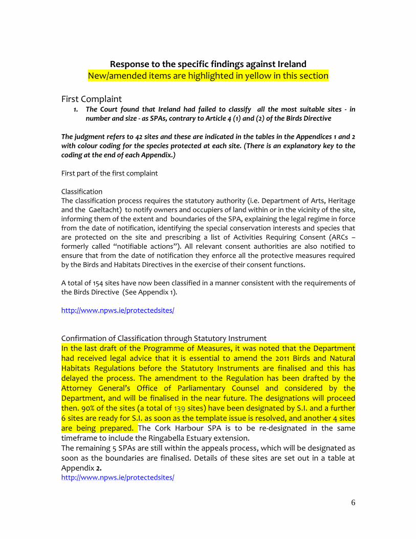
Response to the specific findings against Ireland New/amended items are highlighted in yellow in this section
First Complaint
1. The Court found that Ireland had failed to classify all the most suitable sites - in number and size - as SPAs, contrary to Article 4 (1) and (2) of the Birds Directive
The judgment refers to 42 sites and these are indicated in the tables in the Appendices 1 and 2 with colour coding for the species protected at each site. (There is an explanatory key to the coding at the end of each Appendix.) First part of the first complaint Classification The classification process requires the statutory authority (i.e. Department of Arts, Heritage and the Gaeltacht) to notify owners and occupiers of land within or in the vicinity of the site, informing them of the extent and boundaries of the SPA, explaining the legal regime in force from the date of notification, identifying the special conservation interests and species that are protected on the site and prescribing a list of Activities Requiring Consent (ARCs – formerly called “notifiable actions”). All relevant consent authorities are also notified to ensure that from the date of notification they enforce all the protective measures required by the Birds and Habitats Directives in the exercise of their consent functions. A total of 154 sites have now been classified in a manner consistent with the requirements of the Birds Directive (See Appendix 1). http://www.npws.ie/protectedsites/
Confirmation of Classification through Statutory Instrument In the last draft of the Programme of Measures, it was noted that the Department had received legal advice that it is essential to amend the 2011 Birds and Natural Habitats Regulations before the Statutory Instruments are finalised and this has delayed the process. The amendment to the Regulation has been drafted by the Attorney General’s Office of Parliamentary Counsel and considered by the Department, and will be finalised in the near future. The designations will proceed then. 90% of the sites (a total of 139 sites) have been designated by S.I. and a further 6 sites are ready for S.I. as soon as the template issue is resolved, and another 4 sites are being prepared. The Cork Harbour SPA is to be re-designated in the same timeframe to include the Ringabella Estuary extension. The remaining 5 SPAs are still within the appeals process, which will be designated as soon as the boundaries are finalised. Details of these sites are set out in a table at Appendix 2. http://www.npws.ie/protectedsites/
7
Species Selection The Court further referenced certain bird species as being of particular concern either because of declining numbers or insufficient protection measures afforded to ensure their continued survival. In response, Ireland has identified and classified all suitable locations on the basis of available scientific information within the suite of 154 SPAs for the following species: Red Throated Diver, Hen Harrier, Merlin, Peregrine, Golden Plover, Chough, Kingfisher and Corncrake. The Short-eared Owl, also mentioned in the judgment, bred sporadically in the south-west in the 1960s and 1970s, and is occasionally recorded as possibly breeding. It is envisaged that habitat conservation measures in place for Hen Harrier, that is, extensive grazing of rough grassland, no afforestation of heath/bog will provide adequate measures for Short-eared Owl conservation. Second part of the first complaint Site Area Ireland’s SPAs were reviewed in 20082 and Ireland has extended some selected SPAs to ensure that all the important ornithological areas of a site are included within its boundaries. It is considered that all SPA boundaries have the appropriate scientific justification. These sites are indicated with a double asterisk in the tables at Appendix 1 and 2 and all exceed in area their equivalent IBA site.
Outstanding Issues under the first complaint
Confirmation of Classification through Statutory Instrument
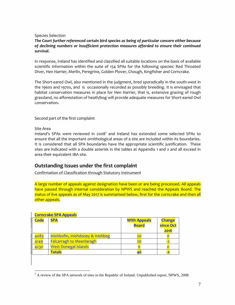
A large number of appeals against designation have been or are being processed. All appeals have passed through internal consideration by NPWS and reached the Appeals Board. The status of live appeals as of May 2017 is summarised below, first for the corncrake and then all other appeals. Corncrake SPA Appeals
Code SPA With Appeals Board
Change since Oct
2016
4083 Inishbofin, Inishdooey & Inishbeg 20 0
4149 Falcarragh to Meenlaragh 20 -2
4230 West Donegal Islands 6 0
Totals 46 -2
2 A review of the SPA network of sites in the Republic of Ireland. Unpublished report, NPWS, 2008
8
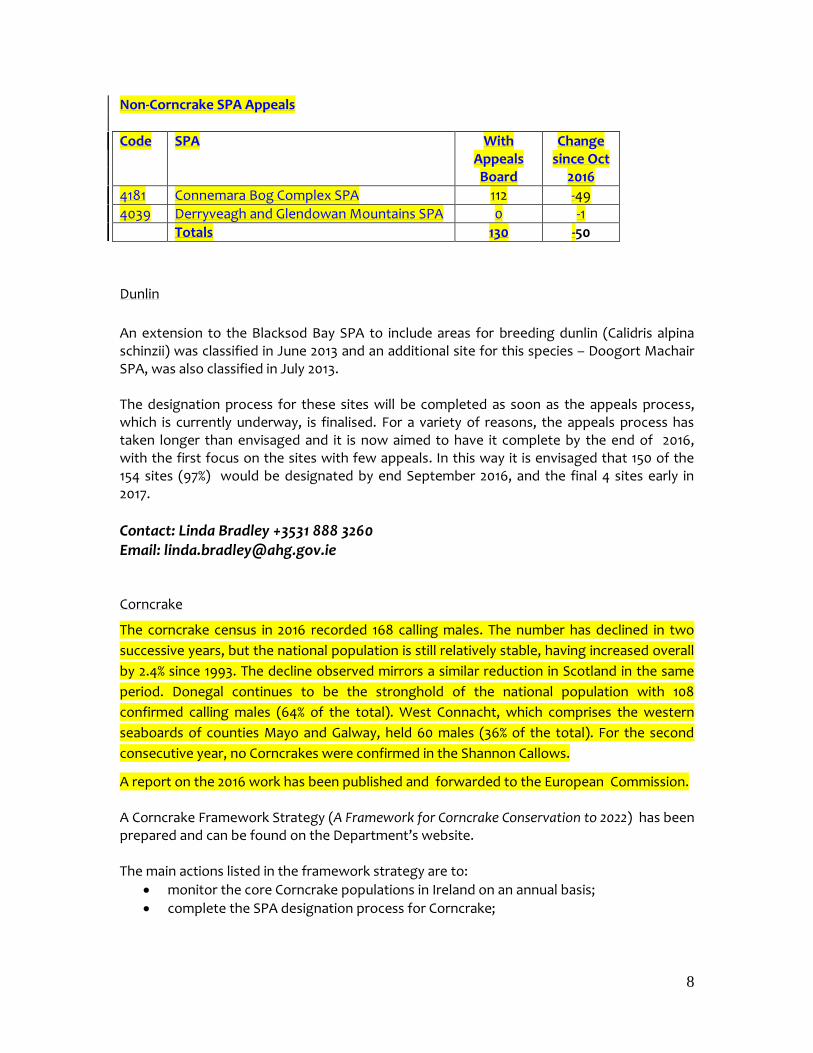
Non-Corncrake SPA Appeals
Code SPA With Appeals Board
Change since Oct
2016
4181 Connemara Bog Complex SPA 112 -49
4039 Derryveagh and Glendowan Mountains SPA 0 -1
Totals 130 -50
Dunlin
An extension to the Blacksod Bay SPA to include areas for breeding dunlin (Calidris alpina schinzii) was classified in June 2013 and an additional site for this species – Doogort Machair SPA, was also classified in July 2013. The designation process for these sites will be completed as soon as the appeals process, which is currently underway, is finalised. For a variety of reasons, the appeals process has taken longer than envisaged and it is now aimed to have it complete by the end of 2016, with the first focus on the sites with few appeals. In this way it is envisaged that 150 of the 154 sites (97%) would be designated by end September 2016, and the final 4 sites early in 2017.
Contact: Linda Bradley +3531 888 3260 Email: [email protected] Corncrake
The corncrake census in 2016 recorded 168 calling males. The number has declined in two
successive years, but the national population is still relatively stable, having increased overall
by 2.4% since 1993. The decline observed mirrors a similar reduction in Scotland in the same
period. Donegal continues to be the stronghold of the national population with 108
confirmed calling males (64% of the total). West Connacht, which comprises the western
seaboards of counties Mayo and Galway, held 60 males (36% of the total). For the second
consecutive year, no Corncrakes were confirmed in the Shannon Callows.
A report on the 2016 work has been published and forwarded to the European Commission. A Corncrake Framework Strategy (A Framework for Corncrake Conservation to 2022) has been prepared and can be found on the Department’s website. The main actions listed in the framework strategy are to:
monitor the core Corncrake populations in Ireland on an annual basis;
complete the SPA designation process for Corncrake;
9
maintain the traditional Corncrake Grant Scheme as a conservation tool for the protection of nesting birds both within the SPA network and in the wider countryside;
set targets to achieve population growth in the SPAs and to underpin these targets with complementary targets for habitat management in these areas;
continue to refine and promote relevant multi-annual agri-environment schemes; and to
continue to enter into management agreements with landholders in important areas in order that land can be exclusively managed as Corncrake habitat.
Complementing the actions set out in the Corncrake strategy, the Department of Agriculture, Food and the Marine has had a series of corncrake measures in its agri-environment Schemes. Ireland’s current Rural Development Programme includes a specific spatially targeted action for the conservation of the Corncrake within the new Agri-Environment scheme (GLAS). This action will promote traditional management practices which are favourable for the conservation of the corncrake, for example the adoption of specific grazing management practices, restrictions on field operations and the adherence to strict cutting practices within the designated areas. Also included is a mandatory requirement for scheme participants to create early cover for the species upon arrival in late Spring/early Summer. Similar to actions under previous schemes, it is targeted at priority Corncrake SPAs, but now excluding the Shannon Callows. In addition, it now affords priority 1 entry to the scheme and as such is available to all farmers in these areas. This action will be complementary to other actions within the Corncrake framework strategy. This action is now mandatory for any farmers applying to GLAS who have land in corncrake
SPAs, whereby scheme participants must enter at least 30% of their land into the Corncrake
measure.
Additional flexibility was introduced in tranche 2 of GLAS to further incentivise uptake, and following a 3rd tranche of offers, there is a total of 67 farmers in corncrake SPAs now in the Scheme, managing 212 ha of habitat.
There are 11 NPWS Farm Plans concerning corncrake currently in operation in the North West
and West, covering 70 ha. There is a very good working relationship between NPWS Agri-
Ecology Unit, local NPWS staff and fieldworkers, the farm planner and the farmers. The
farmers largely understand how important their land is for Corncrakes and there is two-way
communication as to the presence of Corncrakes in their locality. Many of the farmers have
elected to erect the farm plan signs designed by NPWS. In 2015, an additional plan was
designed and implemented in the Mullet Peninsula.
Some of the targets in the Corncrake Strategy have been reached well ahead of the deadline.
It is recognised that ultimately, the success of the Strategy depends on positive engagement
by farmers and non-farming landowners. To that end, NPWS provided training sessions in Q3
2015 to farm planners and agricultural advisors on the ecological requirements of Corncrake
including practical demonstrations on the maintenance, creation, enhancement of habitat.
10
The planners present represented the majority of planners that are designing GLAS plans.
There continues to be regular liaison between farmers and DAHG.
A contract for a draft management plan for the Falcarragh to Meenlaragh SPA is underway
and due for completion by the end of June 2017
Conservation measures carried out in 2016 again included habitat management and the
administration of grant schemes. Publicity activities were also undertaken to seek records
and improve general awareness of the project and Corncrake conservation in Ireland.
172 participants signed agreements to take part in at least one measure of the Corncrake
Grant Scheme (CGS). These agreements provided Corncrake conservation measures in the
form of delayed mowing and Corncrake friendly mowing over a total of 538.2 hectares in
Donegal and West Connacht.
Compensatory Habitat - Dublin Bay
The Court found that Ireland should have designated the inner part of the Tolka estuary, and that an area of 2.2 ha had been lost due to the Dublin Port Tunnel development. The Commission indicated that Ireland must provide compensatory habitat to cover the loss of this area to redshank, curlew and oystercatcher. The Irish authorities were committed to compensating for this habitat loss. All suitable areas within Dublin Bay were already designated and included relevant habitats or species of interest (sites 800004006, North Bull Island, SI 212/2010, and 800004024, South Dublin Bay and River Tolka Estuary, SI 211/2010). The possibility of converting Spartina-infested saltmarsh to mudflat at sites such as Baldoyle and Rogerstown was also considered, but rejected on the grounds of potential damage to habitats which are qualifying interests for the SAC designation of these sites. All sites with the potential for compensatory designation on the east and south east coasts were considered. The sites reviewed (given here with the last 4-digit site code) include Carlingford Lough (4078), Dundalk Bay (4026), Boyne Estuary (4080), , Nanny estuary (4158), Wexford harbour (4076), Bannow (4033) and Tramore 4027) Bays, Ballyteigue (4020), Dungarvan (4032)and Ballymacoda (4023). No mudflats remaining undesignated, and with the relevant species, were identified. A suitable site was eventually found in Ringabella Estuary in Cork and the Cork Harbour SPA (4030) has been extended by 74.14 hectares to include an area of intertidal mudflat that can support a similar waterbird assemblage as the area that was in-filled in Dublin Bay. This extension to the Cork Harbour SPA was advertised and notified on the 11th March 2015. The current Statutory Instrument for Cork Harbour (S.I. 237/2010) will be revoked and a new Statutory Instrument drafted to designate the new, enlarged site More comprehensive information on Ringabella and the Tolka are provided in Appendix 3 below.
11
Ireland will shortly make a notification to the Commission in the context of Article 6(4), paragraph 1, about the compensatory measures undertaken.
(The Second Complaint was rejected by the Court.)
Third Complaint
3. The Court found that Ireland had failed to apply the provisions of the first sentence of Article 4 (4) of the Birds Directive to the areas that should have been classified as SPA, i.e. to take appropriate steps to avoid deterioration of habitats or disturbance of birds within these areas.
To address this complaint and a number of other legal transposition issues in relation to this judgment and other judgments against Ireland in relation to the implementation of the Habitats Directive, the Minister for Arts, Heritage and the Gaeltacht made comprehensive new transposition regulations in September, 2011 – the European Communities (Birds and Natural Habitats) Regulations, 2011 – referred to in this document as the 2011 Regulations. (Complementary transposition provisions are to be found in the Planning and Development (Amendment) Act, 2010. Regulation 15 of the 2011 Regulations provides for the identification and notification to landholders and to the public of “candidate special protection areas”. The Minister may make a direction specifying activities that may not be carried out without his or her consent, and the provisions of Regulation 42 (appropriate assessment).
Regulation 27(4) obliges public authorities in the exercise of their functions, to “take the appropriate steps to avoid, in candidate special protection areas, pollution and deterioration of habitats and any disturbances affecting the birds insofar as these would be significant in relation to the objectives of Article 4 of the Birds Directive”. Also, Regulation 35 (General provisions for the prevention of damage to European Sites) applies to candidate SPAs. These provisions combine to provide a strong legal mechanism for the protection of unclassified sites as required Article 4(4).
Fourth Complaint
4. The Court found that Ireland had failed to transpose and apply obligations to protect birds in the wider countryside as required by Article 4(4) of the Birds Directive
Wider Countryside Measures In response Ireland has introduced new measures, and built upon existing activity, to benefit the conservation of birds in the wider countryside. Under the new Rural Development Programme, DAFM has developed a range of targeted actions within GLAS to assist in the conservation of threatened species where they pertain to farmland within Natura 2000 and in the wider countryside. These measures which have been developed in tandem with DAHG, are tailored to complement existing actions for a wide
12
range of species. GLAS is a highly targeted scheme, and key to its design was the identification of a number of Priority Environmental Assets, primarily related to vulnerable habitats including Natura and uplands/commonages, but also including others such as high status and vulnerable water sites which are key to maintaining aquatic biodiversity. The corncrake action is one of seven key bird groupings having a specific spatially targeted action, with the others being Grey partridge, chough, breeding waders, twite, geese and swans and hen harrier. All holdings with target habitats for these species have been pre-identified and the areas of importance mapped at farm level. The presence of one or more of these habitats (environmental assets) on any farm guarantees priority access to the new scheme. The level of uptake for these actions in Tranches 1 and 2 of GLAS is: Grey partridge = 102 farmers, chough = 615 farmers, breeding waders = 108 farmers, twite = 331 farmers, geese and swans = 1049 farmers and hen harrier = 2145 farmers. Apart from the 7 bird actions prioritised under GLAS in the RDP, which have many indirect benefits for other bird species, a range of other actions have been included in the Scheme to enhance the availability and quality of farmland habitats for birds For example (figures in brackets show farmer participation levels) the hedgerow planting (7455) and rejuvenation actions (coppicing (5013) and laying (1482) will improve the range and quality of nesting and foraging habitat for a number of bird species including owls and kestrels. The wild bird cover action (7467), which involves planting wild bird cover seed mixture, will benefit a range of birds but will particularly benefit seed eating birds such as yellowhammer and skylark. This action has been given tier 1 priority status to ensure a high level of uptake. The low input permanent pasture (27877) and traditional hay meadow (9853) actions, which support the development of more traditional rough grazing areas and meadows, will have wide ranging benefits for a number of species but will especially benefit ground nesting species such as snipe and , whinchat. Another action supports a range of species through the installation of bird boxes (11,816). The GLAS specification also encourages farmers to think wildlife at all times and follow the code of good practice for the responsible use of rodenticides to minimise the impacts on non-target species such as owls and other birds of prey. In addition to the above, key actions for water quality include riparian margins and the protection of watercourses action.
See GLAS terms and conditions and specifications for further details. https://www.agriculture.gov.ie/media/migration/farmingschemesandpayments/glastranche2/GLASTCsTranche2031115.pdf The Minister for Agriculture, Food and Marine has also announced that there will be a scheme for hen harrier under the Locally-led Agri-environment scheme (LLAES) initiative under the RDP and this measure is currently under development and discussion with the Commission. . This Scheme aims to provide complementary supports to the GLAS Hen harrier action, but through innovative approaches taking into account both strategic and site specific needs of this and other upland species. DAHG is providing advice to DAFM as it develops the Scheme. Other relevant activities include:
13
Ongoing active engagement between relevant Government Departments (such as the Department of Agriculture, Food and the Marine (DAFM), the Department of the Environment, Community and Local Government (DECLG) and the Department of Arts, Heritage and the Gaeltacht (DAHG)) public agencies and others, on key issues such as the Rural Development Programme, GLAS and the Locally Led Agri-Environment Scheme. This engagement is informed by a Prioritised Action Framework which identifies Ireland’s priorities for nature conservation related to the EU Nature Directives. See below for further details.
The contract for the operation of the Locally Led Agri-Environment Scheme for Hen Harrier has started. This Scheme being rolled out by the Department of Agriculture, Food and the Marine under the European Innovation Partnership measure of the Irish RDP. The Hen Harrier scheme will be the single biggest of these new partnerships, with a budget of between €20-25m. Its main objectives include the sustainable management of farmland in the most important areas for Hen Harrier, with a strong socio-economic focus in these marginal agricultural areas, and fostering good relations through locally-led solutions between farmers, State bodies and other stakeholders.
Engagement between the Forest Service of DAFM and DAHG on biodiversity elements in the management of forestry.
Commencement in December of DAFM funded SHINE project in University College Cork; it will investigate Hen Harrier distribution and breeding success in relation to forest management practices and climate; identify threats to Hen Harriers in relation to forest management; examine the role of forest management in enhancing habitat value of forests for Hen Harriers; determine the vulnerability of Hen Harriers to predation and disturbance; and investigate the role of post-clear felling brash management on Hen Harrier breeding ecology;
Review alternatives to Red Zone Areas for conservation management;
The Grey Partridge Project in Co. Offaly and the inclusion of a grey partridge action as a priority 1 action in GLAS. The target areas for this action have been extended from the previous AEOS target area, area and further expansions are being considered for Tranche 3 of GLAS. Partridge projects are underway in Fingal and Co. Wicklow, and being planned for Donegal.
National curlew surveys contracted and coordinated by NPWS in 2015 and 2016. Data collected to date has been important in targeting and prioritising farmers in Curlew breeding territories for entry to GLAS, where they will be financially incentivised to manage the habitat for Curlew. Similarly, the data is being shared with the Forest Service in order to reduce the risk of inappropriate planting or forestry works in Curlew breeding territories.
The Minister for Arts Heritage, Regional, Rural and Gaeltacht Affairs has set up a Curlew task Force to advise on what effective measures can be taken to protect curlews and to work towards a recovery.
The EU-funded “Results-based agri-environment pilot scheme (RBAPS)” project focusses in Ireland on Lowland semi-natural grasslands in County Leitrim and the Shannon Callows. The main thrust of the project is trialling a new results based approach to payments under agri-environmental schemes to deliver greater
14
return for biodiversity and the European tax payer. Details of the scheme can be found at http://www.rbaps.eu
Cooperation between a range of key groups to produce a species action plan for Red Grouse – see http://www.greypartridge.ie/conservation/irish-red-grouse-species-action-plan.429.html; and collaboration at 14 sites around the country between hunters, farmers, NGOs and the State sector on habitat management to benefit the red grouse.
Collaboration with agencies and NGOs on birds (breeding waders, Hen Harrier , red grouse etc.) under the INTERREG VA (2014-2020) Programme.
Cooperation between DAHG, the DAFM’s Regional Veterinary Service and Pesticide Registration and Control Division, the State Laboratory, the Golden Eagle Trust and BirdWatch Ireland in relation to the reduction of poisoning risks to reintroduced large raptors and other native raptors and owls.
The publication of annual reports on investigations on birds of prey deaths in Ireland– see http://www.npws.ie/sites/default/files/general/Recording%20and%20Addressing%20Persecution%20and%20Threats%20to%20Our%20Raptors%20(NPWS%20website)_0.pdf
The Campaign for Responsible Rodenticide Use in Ireland (CRRU Ireland) was launched in September 2013.
In a tender recently issued by the Office of Government Procurement for pest control services to national and local authorities, the Code of Practice developed by the Campaign for Responsible Rodenticide Use is set out as best practice and for future tenders, it will be necessary to demonstrate compliance with the CRRU Ireland’s forthcoming Best Practice Guidance for Rodent Control and Safe Use of Rodenticides.
Ongoing implementation of the Wildlife Acts and the Birds and Habitats Regulations, 2011
Implementation of the EIA Agriculture Regulations of 2011.
State-funded awareness and other activities by key NGOs including Birdwatch Ireland, Irish Raptor Study Group, Golden Eagle Trust, Irish Red Grouse Association etc.
Removal of curlew from Open Seasons Order in 2012
Ban on the sale of woodcock in 2015 to reduce hunting pressure
Work by BirdWatch Ireland on barn owl collisions with traffic, funded by Transport Infrastructure Ireland
The DAFM 2015 Competitive Call for Research Proposals (see http://www.agriculture.gov.ie/research/2015competitivecallforresearchproposals/) includes the following call under the Forest Research category, which is directly relevant to the development and implementation of the Hen Harrier TRP but potentially beneficial to a wider suite of species: C.6 Ecosystem Services – Biodiversity: Research appropriate forest planning and management within hen harrier habitats. Research should evaluate and address the interaction of forests and forest management with hen harrier and identify opportunities and constraints for existing and/or future forest expansion and production (limited to Small Project
15
[up to 2-year duration, up to €200,000 funding – see the Call Specification document for details]). Specifically, research into practical site-focused planning and management measures that: ¾¾ increase the habitat value of forests for Hen Harrier throughout the forest rotation, through the application of (for example) varied rotation lengths, the design and management of forest-related open space, targeted forest removal and site restoration; and reduce the influence of pressures such as predation, fire and operational disturbance on Hen Harrier breeding and fledgling success within forest-related habitats (e.g. 2nd rotation pre-thicket forest, ridelines). Project proposals have been received are currently being evaluated.
An Action Plan for the Wider Countryside DECLG and DAHG grant aided BWI’s implementation programme of group species action plans for birds in Ireland until 2015. The project worked to facilitate and deliver on the implementation of Action Plans (previously funded by DEHLG 2009 – 2011), including development of multi-stakeholder-based funding applications and identify partnership working opportunities; effective communication of the outputs of the plans and follow on steps with all stakeholders; assisting in the incorporation of actions assigned to the stakeholders into their respective business plans; assistance in the reporting on the status of Irish birds across the national territory; and in policy development areas that require particular focus such as land management and species protection.
The 10 Group Species Action plans were reviewed by BirdWatch Ireland where species-specific priorities and other priority issues/policies were identified The review was provided in the report “BirdWatch Ireland’s Group Species Action Plans for Irish Birds: Prioritisation of actions, species priorities and implementation” and can be accessed at http://www.birdwatchireland.ie/LinkClick.aspx?fileticket=a%2bb%2fvdQUngs%3d&tabid=1426
As BirdWatch Ireland’s action plans span 10 individual but overlapping groups of birds covering some 450 actions this prioritisation approach was a necessary step to ensure that the correct species and the appropriate actions attracted the most conservation focus. The report includes a review of implementation to date.
The prioritisation exercise identified two groups breeding waders (including Curlew, Lapwing and Dunlin) and farmland birds (including Skylark, Whinchat, Twite, Corncrake, Grey Partridge and Barn Owl) that would most benefit from management measures. Agri-environment measures are in place that will have both direct and indirect benefits for most of these species. Relevant measures include low-input permanent pasture and traditional hay meadow. DAHG is currently considering what additional work, if any, is necessary for whinchat, which is not currently targeted by a specific measure. When the structure of LLAES schemes is finalised, and GLAS is fully operational, including ongoing
16
revisions to some measures, further analysis of what other gaps exist in regard to key groups It is also expected that some species such as skylark and meadow pipit that were severely affected by the freezing conditions in 2010 will show a recovery from the losses noted in the Article 12 report.
Fifth Complaint
5. The Court found that Ireland had not adequately transposed or applied of Article 6(2)-(4) of the Habitats Directive, i.e. to ensure that SPAs were not subject to deterioration, to ensure that plans or projects which could have an adverse impact on SPAs were subject to appropriate assessment in the decision making process.
5a) Birds and Natural Habitats Regulations
In response to this element of the judgment DAHG and DECLG have undertaken a programme of legislative changes to address the transposition issues. As referred to above these include a of comprehensive revision of the e the planning code and of the 1997 Habitats Regulations. See revised European Communities (Birds and Natural Habitats) Regulations 2011 (S.I. 477/2011). An amendment to the Regulations is currently being completed to fully align the classification and designation procedures. http://www.irishstatutebook.ie/2011/en/si/0477.html and the Planning and Development (Amendment) Act, 2010 http://www.irishstatutebook.ie/2010/en/act/pub/0030/ 4b) The Court specifically found inadequate transposition of Article 6(2) in relation to the controls of recreational activities in protected sites. Control of Recreational Activities In response, on 18th June 2010, new regulations were issued governing recreational activity (in particular, the use of recreational vehicles and watercraft). See: European Communities (Birds and Natural Habitats) (Control of Recreational Activities) Regulations 2010 (S.I. No. 293/2010). These are now incorporated within the 2011 Regulations. http://www.irishstatutebook.ie/2010/en/si/0293.html
4c) The Court further found that Ireland had failed to comply with Article 6 (3) and (4)
of the Habitats Directive in respect of plans.
Planning and Development Amendment Act
The Planning and Development (Amendment) Act 2010 includes amendments to
underpin the legal basis for Appropriate Assessment to be carried out for any plan or
17
project which may impact on the integrity of a Natura site: these provisions have
been commenced.
See: Planning and Development (Amendment) Act 2010
http://www.irishstatutebook.ie/2010/en/act/pub/0030/index.html
DECLG contacted planning authorities by way of circular letter (PSSP 5/2011 on 1 July
2011) to ensure compliance of existing development plans and local area plans with
the Directive, notwithstanding the ongoing variations and reviews of existing plans
by planning authorities in the context of their statutory reviews and core strategy
obligations under the Planning and Development (Amendment) Act 2010, all of which
are also subject to the Habitats Directive appropriate assessment process under the
2010 Act delivering comprehensive compliance in this regard thus further expediting
the elimination of any residual 'existing plans'. There are also existing time-bound
requirements for periodic review of forward plans, independent of the Department’s
specific instruction regarding any non-compliant plans or part of a plan. Any non-
compliant plans therefore are subject to a statutory sunset in addition to the
Department’s efforts to expedite the elimination of ’existing plans’.
The Department contacted planning authorities by way of circular letter (PL 16/2013
of 28 August 2013) reminding all planning authorities to ensure that any non-
compliant plans are brought into compliance in a timely manner. The Department
specifically requested those planning authorities who have ‘existing plans’ in place
which encompass Hen Harrier SPAs to fully satisfy themselves as to the compliance
of their land use plans (both development plans and local area plans) that pre-dated
the commencement of the relevant 2010 Act provisions, paying particular attention
to the zoning of environmentally sensitive lands for major developments, e.g. wind
farms, where there are sensitivities in regards to the Hen Harrier SPAs. The
Department reported the outcome of this analysis to the Commission (Letter from
Planning Section on 19 November 2013 – see position as set out below) and
confirmation from the relevant planning authorities regarding compliance of their
land use plan objectives with the Planning and Development (Amendment) Act 2010.
In this context, it is not deemed necessary and accordingly not proposed to make
further amendments to primary legislation on this issue, especially as the existing
provisions in the Planning and Development (Amendment) Act 2010 are being
implemented sufficiently. However, the Department continues to keep the matter
under consideration and monitors compliance of both existing and new plan
objectives.
18
Hen Harrier SPAs (Laois, Offaly, Cork, Kerry, Limerick, Tipperary, Monaghan, Clare
and Galway)
The position in regard to the nine planning authorities with Hen Harrier SPAs (Laois,
Offaly, Cork, Kerry, Limerick, Tipperary, Monaghan, Clare and Galway) is as follows:
Eight of the planning authorities (Laois, Offaly, Kerry, Limerick, Tipperary, Monaghan,
Clare and Galway) concerned have confirmed that their relevant plans are fully
compliant with the Habitats and Birds Directives.
In the case of Cork County Council, the Council has outlined that, in relation to the
existing County Development Plan 2009-15, the plan does not contain wind energy
land-use zoning maps. However, it does contain a Wind Energy Strategy which
includes an indicative map (unscaled) identifying certain parts of the county as
“strategic search” areas, where developers are encouraged to focus efforts in the
identification of suitable sites for wind energy initiatives. Some of these search areas
partially overlap with mountainous and upland areas running from the Stacks to
Mullaghareirks and West Limerick Hills Special Protection Area which is designated
for the protection of Hen Harriers. Importantly, the objective relating to the strategic
search area (INF 7-4) states that, in considering the merits of particular planning
applications in such areas, the Planning Authority will have regard to ‘the impact of
nature conservation, in particular avoiding designated and proposed European sites’.
Furthermore, the Council’s wind energy strategy is currently being reviewed in the
context of the review of the County Development Plan (the draft plan was published
for first round of public consultation in January 2014).
The County Cork Hen Harrier SPAs (Sites 4161 and 4162) are all within the Normally
Discouraged Zones as identified on the Wind Energy Strategy Map in the draft County
Development Plan as published in December 2013. In addition, it has been proposed
through the material amendments to include a 500m buffer around these sites to be
included in the Normally Discouraged Zone.
It is further proposed through the material amendments
· to include all Natura 2000 sites within the Normally Discouraged Zone (some parts of
some Natura 2000 sites had not been included within this zone on publication of the
draft CDP); and
· to include an 800m buffer around SPAs designated for the protection of Wetlands
and Waterbirds within the Normally Discouraged Zone.
19
The proposed policy for the Normally Discouraged Zone is as follows:
ED 3-6 Commercial wind energy developments will be discouraged in these
area which are considered to be sensitive to adverse impacts associated with
this form of development (either individually or in combination with other
developments). Only in exceptional circumstances where it is clear that
adverse impacts do not arise will proposals be considered.
The Public Consultation phase for the proposed material amendments on the draft
Cork County Development Plan closed on 2 October, 2014. Following this the Cork
County Development Plans scheduled to be adopted before 8 January, 2015.
Remaining Planning Authorities and Compliance with the Habitats Directive
The focus of the Commission to date has been on the existing plans relating to the
hen harrier (i.e. the 9 counties which was the basis of the original concerns of the
Commission) which are reported on above. In October 2013 the Department made a
commitment to provide information on all counties compliance with the Directive. In
this regard, the Department contacted the remaining 19 planning authorities
specifically requesting those authorities who have ‘existing plans’ in place to fully
satisfy themselves as to the compliance of their land use plans (both development
plans and local area plans) that pre-dated the commencement of the relevant
provisions of the Planning and Development (Amendment) Act 2010.
The position established in regard to these 19 planning authorities (Carlow, Cavan,
Donegal, Dun Laoghaire Rathdown, Fingal, Kildare, Kilkenny, Leitrim, Longford,
Louth, Mayo, Meath, Roscommon, Sligo, South Dublin, Waterford, Westmeath,
Wexford and Wicklow) is summarised as follows (including in the table below):
· A total of 12 planning authorities (Cavan, Dun Laoighaire Rathdown, Kilkenny,
Leitrim, Louth, Mayo, Meath, Roscommon, Sligo, South Dublin, Waterford and
Westmeath) have confirmed that their relevant plans are fully compliant with
the Habitats and Birds Directive.
· A total of 8 planning authorities (Carlow, Cork, Donegal, Fingal, Kildare,
Longford, Wexford and Wicklow) indicated that they have made town or
village plans that are being revised to include statements to the effect that
these plans are in full compliance. Screening of all planning applications for
20
AA will be strictly applied in the areas covered by these plans. However, it is
very important to note that the plans of these planning authorities are for
urban areas that do not contain relevant habitats and the revisions will be
primarily aimed at demonstrating that any adverse effects on the relevant
habitats are not anticipated.
The Department will continue to monitor both existing and new plan objectives to
ensure of their compliance with Article 6 (3) and (4) of the Habitats Directive
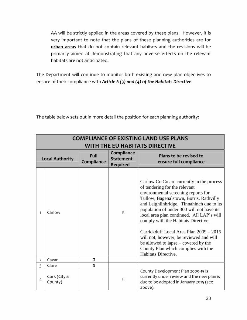
The table below sets out in more detail the position for each planning authority:
COMPLIANCE OF EXISTING LAND USE PLANS WITH THE EU HABITATS DIRECTIVE
Local Authority Full
Compliance
Compliance Statement Required
Plans to be revised to ensure full compliance
1 Carlow
Carlow Co Co are currently in the process
of tendering for the relevant
environmental screening reports for
Tullow, Bagenalstown, Borris, Rathvilly
and Leighlinbridge. Tinnahinch due to its
population of under 300 will not have its
local area plan continued. All LAP’s will
comply with the Habitats Directive.
Carrickduff Local Area Plan 2009 – 2015
will not, however, be reviewed and will
be allowed to lapse – covered by the
County Plan which complies with the
Habitats Directive. 2 Cavan
3 Clare
4 Cork (City & County)
County Development Plan 2009-15 is currently under review and the new plan is due to be adopted in January 2015 (see above).
21
Clonakilty, Fermoy, Mallow and Youghal Town DP will be replaced by Local Area Plans as part of review of existing Electoral
Area LAPs for Cork County. The review of
existing Electoral Area LAPs for Cork
County is due to commence on 14th
December 2015 and will comply with the
Habitats Directive.
5 Donegal
Ballyshannon LAP - Work has commenced in the making of a new plan for Ballyshannon which will comply with Habitats Directive. It is anticipated that the Local Area Plan will be made no earlier than March 2015.
6 Dun Laoghaire Rathdown
7 Fingal Dublin Airport LAP – Review of this LAP due to commence early 2016 and will comply with Habitats Directive.
8 Galway
9 Kerry
10 Kildare Sallins LAP – Currently under review, due
for adoption in Feb 2016 and will comply with the Habitats Directive.
11 Kilkenny
12 Laois
13 Leitrim
14 Limerick (City & County)
15 Longford
Preliminary work has now started on the
Longford Town LAP which will include
lands previously identified as part of the
Northern and Southern Environs LAPs. It
is likely that the Plan will be made in the
third quarter of 2016. It will comply with
the provisions of the Habitats Directive 16 Louth
17 Mayo
18 Meath
19 Monaghan
20 Offaly
21 Roscommon
22 Sligo
23 South Dublin
24 Tipperary
22
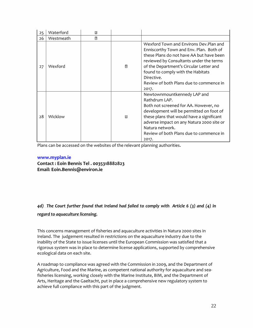
25 Waterford
26 Westmeath
27 Wexford
Wexford Town and Environs Dev.Plan and Enniscorthy Town and Env. Plan. Both of these Plans do not have AA but have been reviewed by Consultants under the terms of the Department’s Circular Letter and found to comply with the Habitats Directive. Review of both Plans due to commence in 2017.
28 Wicklow
Newtownmountkennedy LAP and Rathdrum LAP. Both not screened for AA. However, no development will be permitted on foot of these plans that would have a significant adverse impact on any Natura 2000 site or Natura network. Review of both Plans due to commence in 2017.
Plans can be accessed on the websites of the relevant planning authorities. www.myplan.ie Contact : Eoin Bennis Tel . 0035318882823 Email: [email protected]
4d) The Court further found that Ireland had failed to comply with Article 6 (3) and (4) in
regard to aquaculture licensing.
This concerns management of fisheries and aquaculture activities in Natura 2000 sites in Ireland. The judgement resulted in restrictions on the aquaculture industry due to the inability of the State to issue licenses until the European Commission was satisfied that a rigorous system was in place to determine license applications, supported by comprehensive ecological data on each site. A roadmap to compliance was agreed with the Commission in 2009, and the Department of Agriculture, Food and the Marine, as competent national authority for aquaculture and sea-fisheries licensing, working closely with the Marine Institute, BIM, and the Department of Arts, Heritage and the Gaeltacht, put in place a comprehensive new regulatory system to achieve full compliance with this part of the judgment.
23
A full progress update, is provided in Appendix 5.
Contact: Aquaculture
Contacts: Data collection and appropriate assessments
Fisheries
Sixth Complaint 6. Failure to transpose Article 10 of the Birds Directive (Obligation on the Minister to
encourage Research)
Regulation 57, of the Birds and Natural Habitats Regulations, 2011 - notably paragraphs (c), (d) and (e), assign to the Minister the responsibilities that arise under Article 10 of the Birds Directive.
http://www.irishstatutebook.ie/2011/en/si/0477.html
Update of the programme The Programme will be updated every six months (April and October) to reflect the measures undertaken.

24
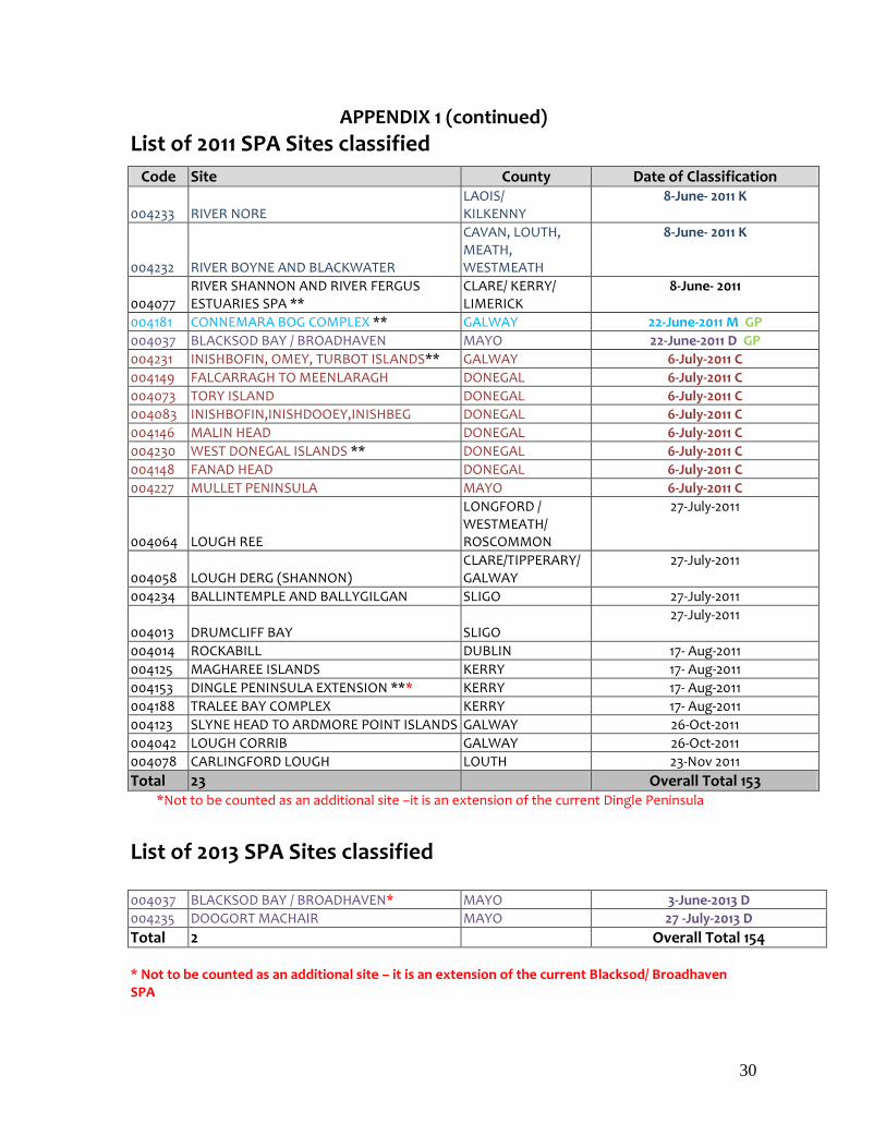
APPENDIX 1
List of Sites classified 2002-2013 ** shows sites where the SPA boundaries were extended to match or exceed the IBA boundary. The Colour coding legend is at the end of the Appendix
List of 2002 SPAs classified
Code Site County Date of Classification 004137 DOVEGROVE CALLOWS SPA OFFALY 27-Feb-02
004142 CREGANNA MARSH SPA GALWAY 27-Feb-02
004096 MIDDLE SHANNON CALLOWS SPA ** GALWAY/OFFALY/ ROSCOMMON
TIPPERARY WESTMEATH
22-Nov-02 C
Total 3
List of 2004 SPA Sites classified Code Site County Date of Classification
004052 CARROWMORE LAKE SPA MAYO 17-Nov-04
004072 STAGS OF BROADHAVEN SPA MAYO 17-Nov-04
004074 ILLANMASTER SPA** MAYO 17-Nov-04
004098 OWENDUFF/NEPHIN COMPLEX SPA** MAYO 17-Nov-04 M GP
Total 4
List of 2006 SPA Sites classified Code Site County Date of Classification
004084 INISHGLORA AND INISHKEERAGH SPA** MAYO 13-Sep-06
004093 TERMONCARRAGH LAKE & ANNAGH MACHAIR SPA
MAYO 13-Sep-06 D C
004177 BILLS ROCKS SPA MAYO 13-Sep-06
004082 GREER'S ISLAND SPA DONEGAL 15-Nov-06
004057 LOUGH DERG SPA ** DONEGAL 15-Nov-06
004066 THE BULL & THE COW ROCKS SPA** CORK 15-Nov-06
004002 SALTEES SPA ** WEXFORD 15-Nov-06
004003 PUFFIN SPA** KERRY 15-Nov-06
004021 OLD HEAD OF KINSALE SPA** CORK 15-Nov-06
004194 HORN HEAD TO FANAD HEAD SPA** DONEGAL 22-Nov-06 CH P
004192 HELVICK HEAD TO BALLYQUINN SPA** WATERFORD 22-Nov-06 CH P
004005 CLIFFS OF MOHER SPA ** CLARE 22-Nov-06 CH
004136 CLARE ISLAND SPA** MAYO 22-Nov-06 CH
004150 WEST DONEGAL COAST SPA DONEGAL 22-Nov-06 CH P
004153 DINGLE PENINSULA SPA** KERRY 22-Nov-06 CH P
004154 IVERAGH PENINSULA SPA KERRY 22-Nov-06 CH P
004155 BEARA PENINSULA SPA CORK 22-Nov-06 CH
004156 SHEEPS HEAD TO TOE HEAD SPA CORK 22-Nov-06 CH P
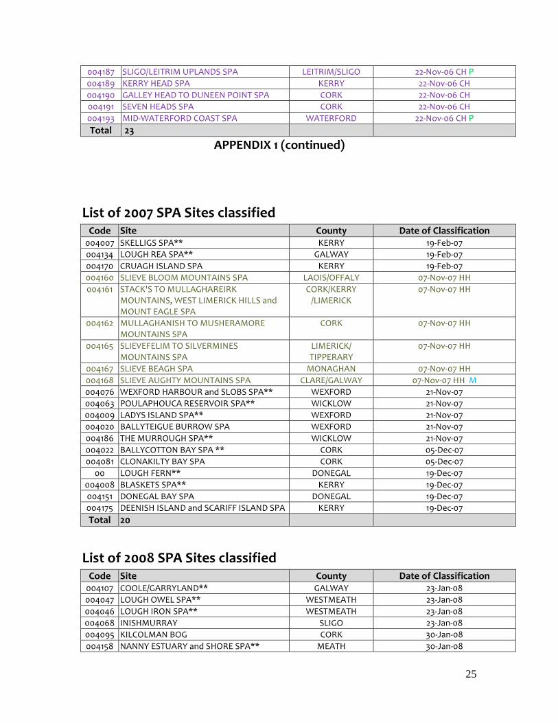
25
004187 SLIGO/LEITRIM UPLANDS SPA LEITRIM/SLIGO 22-Nov-06 CH P
004189 KERRY HEAD SPA KERRY 22-Nov-06 CH
004190 GALLEY HEAD TO DUNEEN POINT SPA CORK 22-Nov-06 CH
004191 SEVEN HEADS SPA CORK 22-Nov-06 CH
004193 MID-WATERFORD COAST SPA WATERFORD 22-Nov-06 CH P
Total 23
APPENDIX 1 (continued)
List of 2007 SPA Sites classified Code Site County Date of Classification
004007 SKELLIGS SPA** KERRY 19-Feb-07
004134 LOUGH REA SPA** GALWAY 19-Feb-07
004170 CRUAGH ISLAND SPA KERRY 19-Feb-07
004160 SLIEVE BLOOM MOUNTAINS SPA LAOIS/OFFALY 07-Nov-07 HH
004161 STACK'S TO MULLAGHAREIRK MOUNTAINS, WEST LIMERICK HILLS and MOUNT EAGLE SPA
CORK/KERRY /LIMERICK
07-Nov-07 HH
004162 MULLAGHANISH TO MUSHERAMORE MOUNTAINS SPA
CORK 07-Nov-07 HH
004165 SLIEVEFELIM TO SILVERMINES MOUNTAINS SPA
LIMERICK/ TIPPERARY
07-Nov-07 HH
004167 SLIEVE BEAGH SPA MONAGHAN 07-Nov-07 HH
004168 SLIEVE AUGHTY MOUNTAINS SPA CLARE/GALWAY 07-Nov-07 HH M
004076 WEXFORD HARBOUR and SLOBS SPA** WEXFORD 21-Nov-07
004063 POULAPHOUCA RESERVOIR SPA** WICKLOW 21-Nov-07
004009 LADYS ISLAND SPA** WEXFORD 21-Nov-07
004020 BALLYTEIGUE BURROW SPA WEXFORD 21-Nov-07
004186 THE MURROUGH SPA** WICKLOW 21-Nov-07
004022 BALLYCOTTON BAY SPA ** CORK 05-Dec-07
004081 CLONAKILTY BAY SPA CORK 05-Dec-07
00 LOUGH FERN** DONEGAL 19-Dec-07
004008 BLASKETS SPA** KERRY 19-Dec-07
004151 DONEGAL BAY SPA DONEGAL 19-Dec-07
004175 DEENISH ISLAND and SCARIFF ISLAND SPA KERRY 19-Dec-07
Total 20
List of 2008 SPA Sites classified Code Site County Date of Classification
004107 COOLE/GARRYLAND** GALWAY 23-Jan-08
004047 LOUGH OWEL SPA** WESTMEATH 23-Jan-08
004046 LOUGH IRON SPA** WESTMEATH 23-Jan-08
004068 INISHMURRAY SLIGO 23-Jan-08
004095 KILCOLMAN BOG CORK 30-Jan-08
004158 NANNY ESTUARY and SHORE SPA** MEATH 30-Jan-08

26
004182 MID-CLARE COAST SPA CLARE 30-Jan-08
004004 INISHKEA ISLANDS SPA** MAYO 13-Feb-08 D
004024 SOUTH DUBLIN BAY AND RIVER TOLKA ESTUARY**
DUBLIN 28-May-08
004006 NORTH BULL ISLAND** DUBLIN 28-May-08
004113 HOWTH HEAD COAST** DUBLIN 28-May-08
004030 CORK HARBOUR CORK 27-Aug-08
Total 12
27
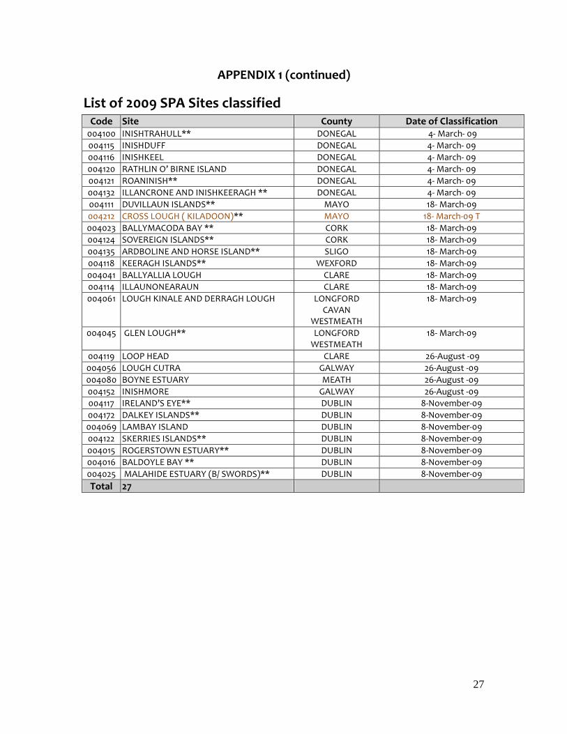
APPENDIX 1 (continued)
List of 2009 SPA Sites classified Code Site County Date of Classification
004100 INISHTRAHULL** DONEGAL 4- March- 09
004115 INISHDUFF DONEGAL 4- March- 09
004116 INISHKEEL DONEGAL 4- March- 09
004120 RATHLIN O’ BIRNE ISLAND DONEGAL 4- March- 09
004121 ROANINISH** DONEGAL 4- March- 09
004132 ILLANCRONE AND INISHKEERAGH ** DONEGAL 4- March- 09
004111 DUVILLAUN ISLANDS** MAYO 18- March-09
004212 CROSS LOUGH ( KILADOON)** MAYO 18- March-09 T
004023 BALLYMACODA BAY ** CORK 18- March-09
004124 SOVEREIGN ISLANDS** CORK 18- March-09
004135 ARDBOLINE AND HORSE ISLAND** SLIGO 18- March-09
004118 KEERAGH ISLANDS** WEXFORD 18- March-09
004041 BALLYALLIA LOUGH CLARE 18- March-09
004114 ILLAUNONEARAUN CLARE 18- March-09
004061 LOUGH KINALE AND DERRAGH LOUGH LONGFORD CAVAN
WESTMEATH
18- March-09
004045 GLEN LOUGH** LONGFORD WESTMEATH
18- March-09
004119 LOOP HEAD CLARE 26-August -09
004056 LOUGH CUTRA GALWAY 26-August -09
004080 BOYNE ESTUARY MEATH 26-August -09
004152 INISHMORE GALWAY 26-August -09
004117 IRELAND’S EYE** DUBLIN 8-November-09
004172 DALKEY ISLANDS** DUBLIN 8-November-09
004069 LAMBAY ISLAND DUBLIN 8-November-09
004122 SKERRIES ISLANDS** DUBLIN 8-November-09
004015 ROGERSTOWN ESTUARY** DUBLIN 8-November-09
004016 BALDOYLE BAY ** DUBLIN 8-November-09
004025 MALAHIDE ESTUARY (B/ SWORDS)** DUBLIN 8-November-09
Total 27
28
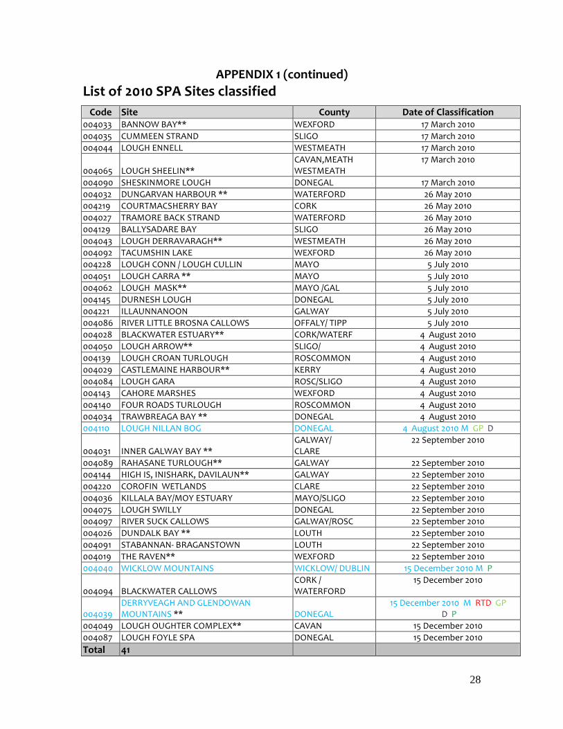
APPENDIX 1 (continued)
List of 2010 SPA Sites classified
Code Site County Date of Classification 004033 BANNOW BAY** WEXFORD 17 March 2010
004035 CUMMEEN STRAND SLIGO 17 March 2010
004044 LOUGH ENNELL WESTMEATH 17 March 2010
004065 LOUGH SHEELIN** CAVAN,MEATH WESTMEATH
17 March 2010
004090 SHESKINMORE LOUGH DONEGAL 17 March 2010
004032 DUNGARVAN HARBOUR ** WATERFORD 26 May 2010
004219 COURTMACSHERRY BAY CORK 26 May 2010
004027 TRAMORE BACK STRAND WATERFORD 26 May 2010
004129 BALLYSADARE BAY SLIGO 26 May 2010
004043 LOUGH DERRAVARAGH** WESTMEATH 26 May 2010
004092 TACUMSHIN LAKE WEXFORD 26 May 2010
004228 LOUGH CONN / LOUGH CULLIN MAYO 5 July 2010
004051 LOUGH CARRA ** MAYO 5 July 2010
004062 LOUGH MASK** MAYO /GAL 5 July 2010
004145 DURNESH LOUGH DONEGAL 5 July 2010
004221 ILLAUNNANOON GALWAY 5 July 2010
004086 RIVER LITTLE BROSNA CALLOWS OFFALY/ TIPP 5 July 2010
004028 BLACKWATER ESTUARY** CORK/WATERF 4 August 2010
004050 LOUGH ARROW** SLIGO/ 4 August 2010
004139 LOUGH CROAN TURLOUGH ROSCOMMON 4 August 2010
004029 CASTLEMAINE HARBOUR** KERRY 4 August 2010
004084 LOUGH GARA ROSC/SLIGO 4 August 2010
004143 CAHORE MARSHES WEXFORD 4 August 2010
004140 FOUR ROADS TURLOUGH ROSCOMMON 4 August 2010
004034 TRAWBREAGA BAY ** DONEGAL 4 August 2010
004110 LOUGH NILLAN BOG DONEGAL 4 August 2010 M GP D
004031 INNER GALWAY BAY ** GALWAY/ CLARE
22 September 2010
004089 RAHASANE TURLOUGH** GALWAY 22 September 2010
004144 HIGH IS, INISHARK, DAVILAUN** GALWAY 22 September 2010
004220 COROFIN WETLANDS CLARE 22 September 2010
004036 KILLALA BAY/MOY ESTUARY MAYO/SLIGO 22 September 2010
004075 LOUGH SWILLY DONEGAL 22 September 2010
004097 RIVER SUCK CALLOWS GALWAY/ROSC 22 September 2010
004026 DUNDALK BAY ** LOUTH 22 September 2010
004091 STABANNAN- BRAGANSTOWN LOUTH 22 September 2010
004019 THE RAVEN** WEXFORD 22 September 2010
004040 WICKLOW MOUNTAINS WICKLOW/ DUBLIN 15 December 2010 M P
004094 BLACKWATER CALLOWS CORK / WATERFORD
15 December 2010
004039 DERRYVEAGH AND GLENDOWAN MOUNTAINS ** DONEGAL
15 December 2010 M RTD GP D P
004049 LOUGH OUGHTER COMPLEX** CAVAN 15 December 2010
004087 LOUGH FOYLE SPA DONEGAL 15 December 2010
Total 41

29
30
APPENDIX 1 (continued)
List of 2011 SPA Sites classified
Code Site County Date of Classification
004233 RIVER NORE LAOIS/ KILKENNY
8-June- 2011 K
004232 RIVER BOYNE AND BLACKWATER
CAVAN, LOUTH, MEATH, WESTMEATH
8-June- 2011 K
004077 RIVER SHANNON AND RIVER FERGUS ESTUARIES SPA **
CLARE/ KERRY/ LIMERICK
8-June- 2011
004181 CONNEMARA BOG COMPLEX ** GALWAY 22-June-2011 M GP
004037 BLACKSOD BAY / BROADHAVEN MAYO 22-June-2011 D GP
004231 INISHBOFIN, OMEY, TURBOT ISLANDS** GALWAY 6-July-2011 C
004149 FALCARRAGH TO MEENLARAGH DONEGAL 6-July-2011 C
004073 TORY ISLAND DONEGAL 6-July-2011 C
004083 INISHBOFIN,INISHDOOEY,INISHBEG DONEGAL 6-July-2011 C
004146 MALIN HEAD DONEGAL 6-July-2011 C
004230 WEST DONEGAL ISLANDS ** DONEGAL 6-July-2011 C
004148 FANAD HEAD DONEGAL 6-July-2011 C
004227 MULLET PENINSULA MAYO 6-July-2011 C
004064 LOUGH REE
LONGFORD / WESTMEATH/ ROSCOMMON
27-July-2011
004058 LOUGH DERG (SHANNON) CLARE/TIPPERARY/ GALWAY
27-July-2011
004234 BALLINTEMPLE AND BALLYGILGAN SLIGO 27-July-2011
004013 DRUMCLIFF BAY SLIGO
27-July-2011
004014 ROCKABILL DUBLIN 17- Aug-2011
004125 MAGHAREE ISLANDS KERRY 17- Aug-2011
004153 DINGLE PENINSULA EXTENSION *** KERRY 17- Aug-2011
004188 TRALEE BAY COMPLEX KERRY 17- Aug-2011
004123 SLYNE HEAD TO ARDMORE POINT ISLANDS GALWAY 26-Oct-2011
004042 LOUGH CORRIB GALWAY 26-Oct-2011
004078 CARLINGFORD LOUGH LOUTH 23-Nov 2011
Total 23 Overall Total 153 *Not to be counted as an additional site –it is an extension of the current Dingle Peninsula
List of 2013 SPA Sites classified
004037 BLACKSOD BAY / BROADHAVEN* MAYO 3-June-2013 D
004235 DOOGORT MACHAIR MAYO 27 -July-2013 D
Total 2 Overall Total 154
* Not to be counted as an additional site – it is an extension of the current Blacksod/ Broadhaven SPA

31
COLOUR CODED KEY - IDENTIFYING 42 SPA SITES FOR THE PROTECTION OF SPECIFIC SPECIES MENTIONED IN THE BIRDS CASE JUDGMENT
D Dunlin Site CH Chough Site
C Corncrake Site HH Hen Harrier Site
M Merlin Site GP Golden Plover Site
K Kingfisher Site T Tern Site
RTD Red-Throated Diver Site P Peregrine Site
32
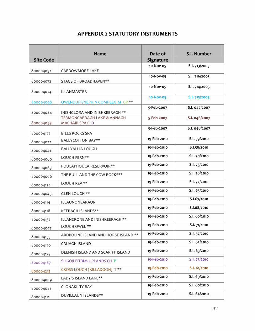
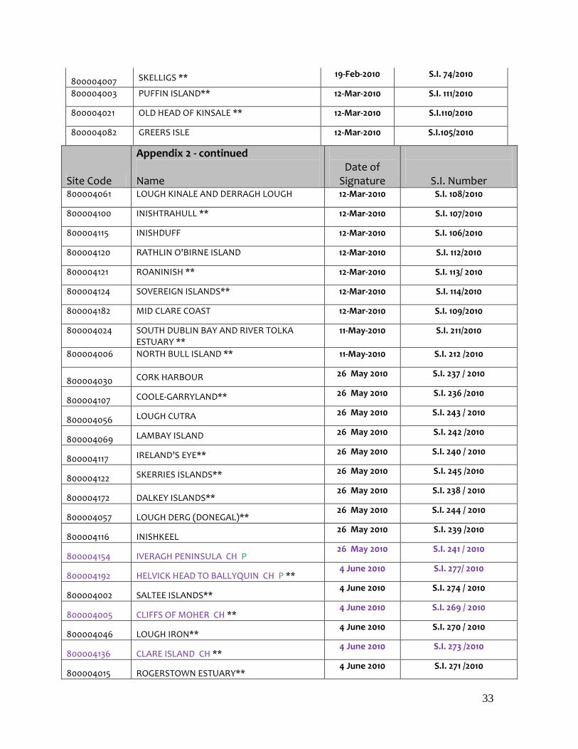
APPENDIX 2 STATUTORY INSTRUMENTS
Site Code Name
Date of
Signature
S.I. Number
800004052
CARROWMORE LAKE
10-Nov-05 S.I. 713/2005
800004072
STAGS OF BROADHAVEN**
10-Nov-05 S.I. 716/2005
800004074
ILLANMASTER
10-Nov-05 S.I. 714/2005
800004098
OWENDUFF/NEPHIN COMPLEX M GP **
10-Nov-05 S.I. 715/2005
800004084
INISHGLORA AND INISHKEERAGH **
5-Feb-2007 S.I. 047/2007
800004093
TERMONCARRAGH LAKE & ANNAGH MACHAIR SPA C D
5-Feb-2007 S.I. 046/2007
800004177
BILLS ROCKS SPA
5-Feb-2007 S.I. 048/2007
800004022 BALLYCOTTON BAY** 19-Feb-2010 S.I. 59/2010
800004041 BALLYALLIA LOUGH 19-Feb-2010 S.I.58/2010
800004060 LOUGH FERN** 19-Feb-2010 S.I. 70/2010
800004063 POULAPHOUCA RESERVOIR** 19-Feb-2010 S.I. 73/2010
800004066 THE BULL AND THE COW ROCKS** 19-Feb-2010 S.I. 76/2010
800004134 LOUGH REA ** 19-Feb-2010 S.I. 72/2010
800004045 GLEN LOUGH ** 19-Feb-2010 S.I. 65/2010
800004114 ILLAUNONEARAUN 19-Feb-2010 S.I.67/2010
800004118 KEERAGH ISLANDS** 19-Feb-2010 S.I.68/2010
800004132 ILLANCRONE AND INISHKEERAGH ** 19-Feb-2010 S.I. 66/2010
800004047 LOUGH OWEL ** 19-Feb-2010 S.I. 71/2010
800004135 ARDBOLINE ISLAND AND HORSE ISLAND ** 19-Feb-2010 S.I. 57/2010
800004170 CRUAGH ISLAND 19-Feb-2010 S.I. 62/2010
800004175 DEENISH ISLAND AND SCARIFF ISLAND 19-Feb-2010 S.I. 63/2010
800004187 SLIGO/LEITRIM UPLANDS CH P 19-Feb-2010 S.I. 75/2010
800004212 CROSS LOUGH (KILLADOON) T ** 19-Feb-2010 S.I. 61/2010
800004009 LADY'S ISLAND LAKE** 19-Feb-2010 S.I. 69/2010
800004081 CLONAKILTY BAY 19-Feb-2010 S.I. 60/2010
800004111 DUVILLAUN ISLANDS** 19-Feb-2010 S.I. 64/2010
33
800004007 SKELLIGS ** 19-Feb-2010 S.I. 74/2010
800004003 PUFFIN ISLAND** 12-Mar-2010 S.I. 111/2010
800004021 OLD HEAD OF KINSALE ** 12-Mar-2010 S.I.110/2010
800004082 GREERS ISLE 12-Mar-2010 S.I.105/2010
Site Code
Appendix 2 - continued Name
Date of
Signature
S.I. Number 800004061 LOUGH KINALE AND DERRAGH LOUGH 12-Mar-2010 S.I. 108/2010
800004100 INISHTRAHULL ** 12-Mar-2010 S.I. 107/2010
800004115 INISHDUFF 12-Mar-2010 S.I. 106/2010
800004120 RATHLIN O'BIRNE ISLAND 12-Mar-2010 S.I. 112/2010
800004121 ROANINISH ** 12-Mar-2010 S.I. 113/ 2010
800004124 SOVEREIGN ISLANDS** 12-Mar-2010 S.I. 114/2010
800004182 MID CLARE COAST 12-Mar-2010 S.I. 109/2010
800004024 SOUTH DUBLIN BAY AND RIVER TOLKA ESTUARY **
11-May-2010 S.I. 211/2010
800004006 NORTH BULL ISLAND ** 11-May-2010 S.I. 212 /2010
800004030 CORK HARBOUR 26 May 2010 S.I. 237 / 2010
800004107 COOLE-GARRYLAND** 26 May 2010 S.I. 236 /2010
800004056 LOUGH CUTRA 26 May 2010 S.I. 243 / 2010
800004069 LAMBAY ISLAND 26 May 2010 S.I. 242 /2010
800004117 IRELAND’S EYE** 26 May 2010 S.I. 240 / 2010
800004122 SKERRIES ISLANDS** 26 May 2010 S.I. 245 /2010
800004172 DALKEY ISLANDS** 26 May 2010 S.I. 238 / 2010
800004057 LOUGH DERG (DONEGAL)** 26 May 2010 S.I. 244 / 2010
800004116 INISHKEEL 26 May 2010 S.I. 239 /2010
800004154 IVERAGH PENINSULA CH P 26 May 2010 S.I. 241 / 2010
800004192 HELVICK HEAD TO BALLYQUIN CH P ** 4 June 2010 S.I. 277/ 2010
800004002 SALTEE ISLANDS** 4 June 2010 S.I. 274 / 2010
800004005 CLIFFS OF MOHER CH ** 4 June 2010 S.I. 269 / 2010
800004046 LOUGH IRON** 4 June 2010 S.I. 270 / 2010
800004136 CLARE ISLAND CH ** 4 June 2010 S.I. 273 /2010
800004015 ROGERSTOWN ESTUARY** 4 June 2010 S.I. 271 /2010
34
800004016 BALDOYLE BAY** 4 June 2010 S.I. 275 /2010
800004008 BLASKET ISLANDS** 4 June 2010 S.I. 272 / 2010
800004190 GALLEY HEAD TO DUNEEN POINT CH 4 June 2010 S.I. 276 / 2010
800004191 SEVEN HEADS CH 4 June 2010 S.I. 268 / 2010
800004150 WEST DONEGAL COAST CH P 30 July 2010 S.I. 389 / 2010
800004090 SHESKINMORE LOUGH 30 July 2010 S.I. 388 /2010
800004156 SHEEP’S HEAD TO TOE HEAD CH P 30 July 2010 S.I. 387 /2010
800004095 KILCOLMAN BOG 30 July 2010 S.I. 386 /2010
Site Code
Appendix 2 - continued Name
Date of
Signature
S.I. Number
800004189 KERRY HEAD CH 30 July 2010 S.I. 385 / 2010
800004137 DOVEGROVE CALLOWS 30 July 2010 S.I. 384 / 2010
800004020 BALLYTEIGUE BURROW 30 July 2010 S.I. 383 / 2010
800004048 LOUGH GARA
16 June 2011
S.I. 288/2011
800004050 LOUGH ARROW **
16 June 2011
S.I. 289/2011
800004065 LOUGH SHEELIN**
16 June 2011
S.I. 290/2011
800004139 LOUGH CROAN TURLOUGH
16 June 2011
S.I. 292/2011
800004143
CAHORE MARSHES
16 June 2011
S.I. 293/2011
800004219 COURTMACSHERRY BAY
16 June 2011
S.I. 296/2011
800004221 ILLAUNNANOON 16 June 2011
S.I. 297/2011
800004145 DURNESH LOUGH
16 June 2011
S.I. 294/2011
800004027 TRAMORE BACK STRAND
16 June 2011
S.I. 286/2011
800004043 LOUGH DERRAVARAGH**
16 June 2011
S.I. 287/2011
800004129 BALLYSADARE BAY
16 June 2011
S.I. 291/2011
800004186 THE MURROUGH**
16 June 2011
S.I. 298/2011
800004025 MALAHIDE ESTUARY **
16 June 2011
S.I. 285/2011
800004151 DONEGAL BAY
16 June 2011
S.I. 295/2011

35
800004051 LOUGH CARRA SPA**
30 June 2011
S.I,340/2011
800004087 LOUGH FOYLE SPA
30 June 2011
S.I.341/2011
800004035 CUMMEEN STRAND SPA
12 July 2011
S.I.376/2011
800004036 KILLALA BAY / MOY ESTUARY
11 October 2011
S.I.522/2011
800004068 INISHMURRAY
14 October 2011
S.I.534/2011
800004019 THE RAVEN**
14 October 2011
S.I. 533/2011
800004091 STABANNAN-BRAGANSTOWN
26 October 2011
S.I.546/2011
800004193 MID-WATERFORD COAST CH P
28 October 2011
S.I. 558 /2011
800004165 SLIEVE FEILIM TO SILVERMINES MTS HH
15- Nov-2011
S.I. 587/2011
800004004 INISHKEA ISLANDS SPA D **
15- Nov-2011
S.I.588/2011

36
Site Code
Appendix 2 - continued Name
Date of
Signature
S.I. Number
800004140 FOUR ROADS TURLOUGH 15- Nov-2011 S.I. 589/2011
800004228 LOUGH CONN AND LOUGH CULLIN 15- Nov-2011 S.I. 590/2011
800004119 LOOP HEAD SPA 15- Nov-2011 S.I. 591/2011
800004033 BANNOW BAY** 15- Nov-2011 S.I. 592/2011
800004167 SLIEVE BEAGH HH 29- Nov-2011 S.I. 617/2011
800004044 LOUGH ENNELL 29- Nov-2011 S.I.618/2011
800004080 BOYNE ESTUARY 5-Dec-2011 S.I. 626/2011
800004162 MULLAGANISH TO MUSHERAMORE MTS HH 5- Dec -2011 S.I. 627/2011
800004110 LOUGH NILLAN BOG SPA M D GP 7- Dec-2011 S.I. 633/2011
800004086 RIVER LITTLE BROSNA CALLOWS (100) 15- Dec-2011
S.I. 652/2011
800004013 DRUMCLIFF BAY 9-Feb-2012 S.I. 40/2012
800004096 MIDDLE SHANNON CALLOWS C ** 9-Feb-2012 S.I. 41/2012
800004168 SLIEVE AUGHTY MTS HH M 21-Mar-2012 S.I.83/2012
80004062 LOUGH MASK ** 21-Mar-2012 S.I.84/2012
80004014 ROCKABILL 21-Mar-2012 S.I. 94/2012
800004220 COROFIN WETLANDS 28-Mar-2012 S.I. 117 /2012
800004158 RIVER NANNY ESTUARY AND SHORE ** 26- Apr-2012 S.I.140/2012
800004125 MAGHAREE ISLANDS 26-Apr-2012 S.I.139/2012
800004076 WEXFORD HARBOUR & SLOBS** 16-May-2012 S.I. 194/2012
800004094 BLACKWATER CALLOWS 16-May-2012 S.I. 191/2012
800004144 HIGH ISLAND, INISHARK AND DAVILAUN** 16-May-2012 S.I.192/2012
800004233 RIVER NORE K 16-May-2012 S.I.193/2012
800004160 SLIEVE BLOOM MTS HH 29- May-2012 S.I.184/2012
800004092 TACUMSHIN LAKE SPA 29- May-2012 S.I.178/2012
800004159 SLYNE HEAD TO ARDMORE POINT ISLANDS SPA 29- May-2012 S.I. 177/2012
800004113 HOWTH HEAD COAST ** 29- May-2012 S.I. 185/2012
800004029 CASTLEMAINE HARBOUR** 3-Jul-2012 S.I. 244/2012
800004034 TRAWBREAGA BAY** 4-Jul-2012 S.I. 261/2012
800004026 DUNDALK BAY ** 3-Aug-2012 S.I. 310/2012

37
800004089 RAHASANE TURLOUGH** 4-Aug-2012 S.I. 311/2012
800004097 RIVER SUCK CALLOWS 2- Oct-2012 S.I. 397/2012
800004075 LOUGH SWILLY 22- Oct-2012 S.I. 592/2012

38
Site Code Appendix 2 - continued Name
Date of
Signature
S.I. Number
800004042 LOUGH CORRIB 22-Oct-2012 S.I. 455/2012
800004064 LOUGH REE 13-Nov-2012 S.I. 456/2012
800004028 BLACKWATER ESTUARY ** 13-Nov-2012 S.I. 590/2012
800004078 CARLINGFORD LOUGH 22-Nov-2012 S.I. 464/2012
800004232 RIVER BOYNE & RIVER BLACKWATER K 21-Nov-2012 S.I. 462/2012
800004234 BALLINTEMPLE & BALLYGILGAN 21-Nov-2012 S.I. 463/2012
800004153 DINGLE PENINSULA CH P ** 23-Nov-2012 S.I. 480/2012
800004161 STACK`S TO MULLAGHAREIRK MOUNTAINS, WEST LIMERICK HILLS AND MOUNT EAGLE HH
23-Nov-2012 S.I. 591/2012
800004049 LOUGH OUGHTER COMPLEX ** 20-Dec-2012 S.I. 585/2012
800004040 WICKLOW MOUNTAINS M P 20-Dec-2012 S.I 586/ 2012
800004155 BEARA PENINSULA CH 20-Dec-2012 S.I 587/ 2012
800004227 MULLET PENINSULA C 25-Feb-13 S.I. 83/ 2013
800004146 MALIN HEAD C 25-Feb-13 S.I. 84 /2013
800004194 HORN HEAD TO FANAD HEAD CH P ** 23-Jul-13 S.I. 281 /2013
800004023 BALLYMACODA BAY 28-Aug13 S.I. 338/13
800004148 FANAD HEAD C 19-Nov-13 S.I.439/13
800004073 TORY ISLAND C 17-Dec-2013 S.I.585/13
Signed S.I.s 139
1 May 2015
SPA Sites Pending Signature
Site Code Name Date of
Signature
S.I. Number
800004032 DUNGARVAN HARBOUR** drafting
800004037 BLACKSOD BAY/BROADHAVEN drafting
800004058 LOUGH DERG drafting
800004142 CREGGANNA MARSH drafting
39
800004188 TRALEE BAY COMPLEX drafting
800004235 DOOGORT MACHAIR D drafting
800004231 INISHBOFIN, OMEY ISLAND AND TURBOT ISLAND **
drafting
800004152 INISHMORE drafting
800004077 RIVER SHANNON AND RIVER FERGUS ESTUARIES**
drafting
800004031 INNER GALWAY BAY**
drafting
COLOUR CODED KEY - IDENTIFYING 42 SPA SITES FOR THE PROTECTION OF SPECIFIC SPECIES MENTIONED IN THE BIRDS CASE JUDGMENT
D Dunlin Site CH Chough Site
C Corncrake Site HH Hen Harrier Site
M Merlin Site GP Golden Plover Site
K Kingfisher Site T Tern Site
RTD Red-Throated Diver Site P Peregrine Site
Appendix 2 - continued
SPA Sites under Appeal
Site Code Name
800004230 WEST DONEGAL ISLANDS**
800004083 INISHBOFIN, INISHDOOEY AND INISHBEG
800004149 FALCARRAGH TO MEENLARAGH
800004181 CONNEMARA BOG COMPLEX **
800004039 DERRYVEAGH AND GLENDOWAN MOUNTAINS**
40
APPENDIX 3
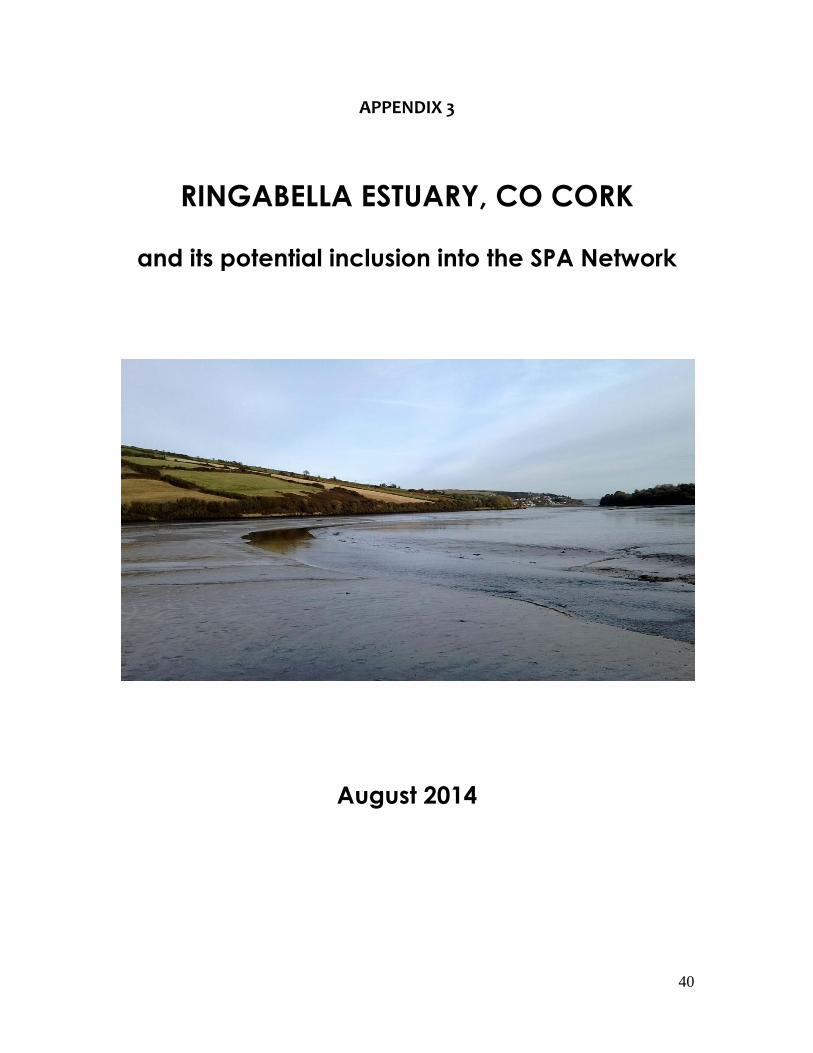
RINGABELLA ESTUARY, CO CORK
and its potential inclusion into the SPA Network
August 2014

41
Contents
1.0 BACKGROUND1. ...........................................................................................
................................................................................................................ 42
2.0 RINGABELLA ESTUARY CO CORK2. ..........................................................
................................................................................................................ 43
2.1 Ecological description of site .......................................................... 43
2.2 Waterbirds of Ringabella Estuary ................................................... 43
3.0 TOLKA ESTUARY, SOUTH DUBLIN BAY3. ....................................................
................................................................................................................ 47
3.1 Ecological description of the site ................................................... 47
3.2 Waterbird species associated with the Tolka Estuary ................. 47
3.3 Waterbird species associated with the inner Tolka Estuary ....... 48
4.0 COMPENSATORY HABITAT – FULFILLMENT OF REQUIREMENTS4. .......
................................................................................................................ 51
5.0 LINK WITH CORK HARBOUR SPA5. ...........................................................
................................................................................................................ 53
6.0 REFERENCES6. ................................................................................................
................................................................................................................ 54
ANNEX 1 – BOUNDARY MAPPING ..................................................... 557.
42
1.0 BACKGROUND
In response to the judgment of the Court of Justice of the European Communities
(Case C-418/04) Ireland has agreed to identify and include a suitable area of
coastal wetland into Ireland’s Special Protection Area (SPA) Network as
compensation for an area of intertidal habitat (circa of 2.2ha) of the inner Tolka
Estuary, Co Dublin. This area ought to have been included in the South Dublin
Bay and River Tolka Estuary SPA but was subject to in-filling as part of the Dublin
Port Tunnel works.
The broad criteria that was agreed to identify a suitable compensatory site were:
1. it must contain at least 2.2 ha of suitable habitat (i.e. intertidal mudflat);
2. it should be able to support a similar waterbird assemblage as the area
that was in-filled;
3. the site boundaries are to be defined on an ecological basis;
4. for the purposes of on-going appropriate protection and management
the area in question should be incorporated into an existing SPA
designated for wintering waterbirds; and
5. ideally the compensatory area is to be located as close as practicable to
the area where the habitat was lost.
After an investigation of Dublin Bay and the series of wetland sites immediately to
the north and south no suitable areas were identified. This was due to the fact
that all suitable habitats in these areas were already included in the SPA
network. After further investigation, Ringabella Estuary in Co Cork was identified
as a strong candidate and this document outlines its suitability and the
consequences should it be successfully designated.
43
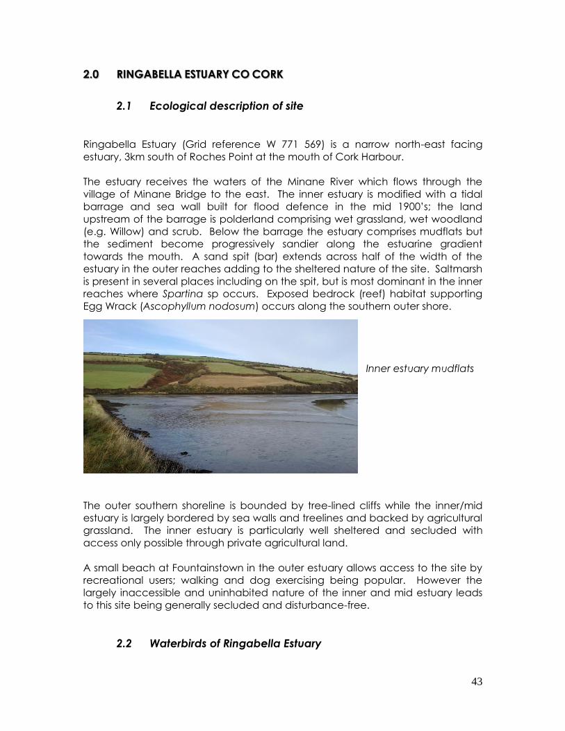
2.0 RINGABELLA ESTUARY CO CORK
2.1 Ecological description of site
Ringabella Estuary (Grid reference W 771 569) is a narrow north-east facing
estuary, 3km south of Roches Point at the mouth of Cork Harbour.
The estuary receives the waters of the Minane River which flows through the
village of Minane Bridge to the east. The inner estuary is modified with a tidal
barrage and sea wall built for flood defence in the mid 1900’s; the land
upstream of the barrage is polderland comprising wet grassland, wet woodland
(e.g. Willow) and scrub. Below the barrage the estuary comprises mudflats but
the sediment become progressively sandier along the estuarine gradient
towards the mouth. A sand spit (bar) extends across half of the width of the
estuary in the outer reaches adding to the sheltered nature of the site. Saltmarsh
is present in several places including on the spit, but is most dominant in the inner
reaches where Spartina sp occurs. Exposed bedrock (reef) habitat supporting
Egg Wrack (Ascophyllum nodosum) occurs along the southern outer shore.
Inner estuary mudflats
The outer southern shoreline is bounded by tree-lined cliffs while the inner/mid
estuary is largely bordered by sea walls and treelines and backed by agricultural
grassland. The inner estuary is particularly well sheltered and secluded with
access only possible through private agricultural land.
A small beach at Fountainstown in the outer estuary allows access to the site by
recreational users; walking and dog exercising being popular. However the
largely inaccessible and uninhabited nature of the inner and mid estuary leads
to this site being generally secluded and disturbance-free.
2.2 Waterbirds of Ringabella Estuary

44
Ringabella Estuary (Ringabella Creek) has been counted as part of the Irish
Wetland Bird Survey (I-WeBS) since the season 1997/98. A total of 44 waterbird
species have been recorded at the site including 15 waterfowl (and allies), 19
waders, seven gulls and three others. During the 15-year count period (1997/98 –
2011/12) the site has regularly supported numbers of Black-tailed Godwit that
have exceeded the all-Ireland threshold. The wader species that have occurred
in greatest numbers (peak annual maxima in brackets) are Lapwing (317), Dunlin
(253), Black-tailed Godwit (430), Curlew (269), and Redshank (125).
Ringabella Estuary was counted as part of the 2010/11 Waterbird Survey
programme of Cork Harbour. The estuary was divided into two count subsites;
the inner subsite covering the area from the inner estuary sea wall east as far as
the sand spit; and the outer subsite covering the outer estuary from the sand spit
to the proposed seaward extent of the site. The total count area was 122 ha.
A total of 22 waterbird species were recorded (Table 1) including nine wader
species. Numbers of Black-tailed Godwit that exceeded the all-Ireland threshold
were recorded in the inner estuary subsite during two low tide surveys (Table 1).
Agricultural fields to the north of the estuary (counted separately to the estuary)
were notable for regularly holding flocks of foraging Black-tailed Godwits and
Lapwings; peak numbers recorded were 86 and 179 individuals respectively.
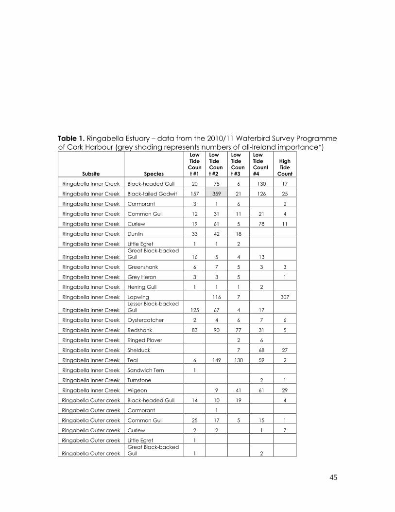
45
Table 1. Ringabella Estuary – data from the 2010/11 Waterbird Survey Programme
of Cork Harbour (grey shading represents numbers of all-Ireland importance*)
Subsite Species
Low
Tide
Coun
t #1
Low
Tide
Coun
t #2
Low
Tide
Coun
t #3
Low
Tide
Count
#4
High
Tide
Count
Ringabella Inner Creek Black-headed Gull 20 75 6 130 17
Ringabella Inner Creek Black-tailed Godwit 157 359 21 126 25
Ringabella Inner Creek Cormorant 3 1 6 2
Ringabella Inner Creek Common Gull 12 31 11 21 4
Ringabella Inner Creek Curlew 19 61 5 78 11
Ringabella Inner Creek Dunlin 33 42 18
Ringabella Inner Creek Little Egret 1 1 2
Ringabella Inner Creek
Great Black-backed
Gull 16 5 4 13
Ringabella Inner Creek Greenshank 6 7 5 3 3
Ringabella Inner Creek Grey Heron 3 3 5 1
Ringabella Inner Creek Herring Gull 1 1 1 2
Ringabella Inner Creek Lapwing 116 7 307
Ringabella Inner Creek
Lesser Black-backed
Gull 125 67 4 17
Ringabella Inner Creek Oystercatcher 2 4 6 7 6
Ringabella Inner Creek Redshank 83 90 77 31 5
Ringabella Inner Creek Ringed Plover 2 6
Ringabella Inner Creek Shelduck 7 68 27
Ringabella Inner Creek Teal 6 149 130 59 2
Ringabella Inner Creek Sandwich Tern 1
Ringabella Inner Creek Turnstone 2 1
Ringabella Inner Creek Wigeon 9 41 61 29
Ringabella Outer creek Black-headed Gull 14 10 19 4
Ringabella Outer creek Cormorant 1
Ringabella Outer creek Common Gull 25 17 5 15 1
Ringabella Outer creek Curlew 2 2 1 7
Ringabella Outer creek Little Egret 1
Ringabella Outer creek
Great Black-backed
Gull 1 2
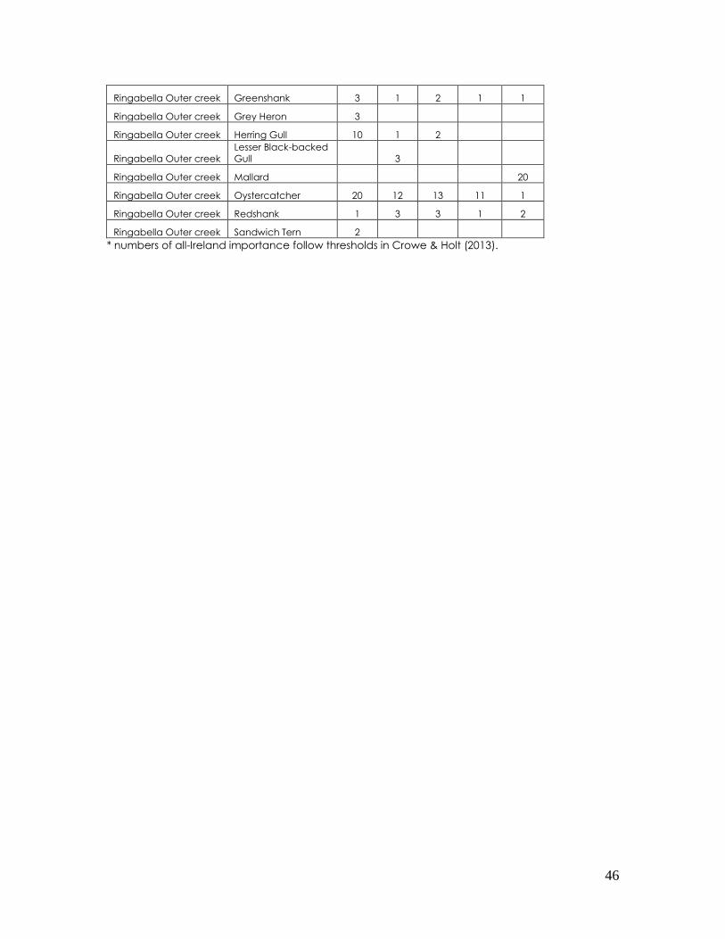
46
Ringabella Outer creek Greenshank 3 1 2 1 1
Ringabella Outer creek Grey Heron 3
Ringabella Outer creek Herring Gull 10 1 2
Ringabella Outer creek
Lesser Black-backed
Gull 3
Ringabella Outer creek Mallard 20
Ringabella Outer creek Oystercatcher 20 12 13 11 1
Ringabella Outer creek Redshank 1 3 3 1 2
Ringabella Outer creek Sandwich Tern 2
* numbers of all-Ireland importance follow thresholds in Crowe & Holt (2013).
47
3.0 TOLKA ESTUARY, SOUTH DUBLIN BAY
3.1 Ecological description of the site
The Tolka Estuary is situated to the north of the River Liffey in Dublin Bay and is
part of the South Dublin Bay and River Tolka Estuary SPA (Site Code 4024).
The estuary is relatively shallow with extensive mud/sand flats and extends over
an area of 3.58km². The vast majority of riverbank, shoreline and channel in the
estuary has been modified and manipulated over time to allow for urban
development (e.g. channelisation of the river, building of retaining walls, Dublin
Port Company). Sediments vary from soft muds with a high organic content in
the inner estuary to exposed, well-aerated sands off the Bull Wall (NPWS, 2012).
The benthic community was classified (by data extrapolation) as ‘fine sand to
sandy mud with Pygospio elegans and Crangon crangon’ by NPWS (2013), a
community that occurs in the ‘muddier’ sections of Dublin Bay, including the
mudflats on the landward side of Bull Island.
3.2 Waterbird species associated with the Tolka Estuary
The Tolka Estuary was counted as part of the 2011/12 Waterbird Survey
Programme of Dublin Bay. The estuary as a whole encompasses intertidal and
subtidal estuarine habitats extending from the inner estuary eastwards to the Bull
Wall; a total count area of 405 ha. The estuary was subdivided into five subsites,
of which the inner subsite (0UL43) extends into the inner estuary as far as a
bridge. The area upstream of the bridge, that once contained the 2.2ha of
intertidal mudflat which is now in-filled, was not counted. Summary data for the
Tolka Estuary are provided in Table 2. A total of 27 waterbird species were
counted across the estuary as a whole.
The Tolka Estuary count area described above is comparable with an area
surveyed in the 2012/13 season by Nairn (2013) for Dublin Port Company.
Whole estuary low tide counts during the 2011/12 season (NPWS) yielded total
counts ranging from 1,994 to 5,659 waterbirds, while Nairn (2013) recorded whole
site counts ranging from 2,601 to 7,929 waterbirds. An additional count in March
2013 recorded a total of 15,563 waterbirds which was dominated by 8,573 Black-
headed Gulls (Nairn, 2013). Table 2 shows summary data for the Tolka Estuary
from the 2011/12 season (NPWS) and peak counts recorded by Nairn (2013). Five
species occur regularly in numbers exceeding the threshold of all-Ireland
importance.

48
Table 2. Tolka Estuary – low tide data from the 2011/12 Waterbird Survey
Programme of Dublin Bay (peak low tide count in bold; light grey shading
represents numbers of all-Ireland importance) plus peak counts from Nairn, 2013.
Species
Low
Tide
Count
#1
Low
Tide
Count
#2
Low
Tide
Count
#3
Low
Tide
Count
#4
Peak 2012/13
(Nairn, 2013)
Mute Swan 1 2 2
Light-bellied Brent Goose 349 80 230 270
Shelduck 9 15 20
Wigeon 11 36 26
Teal 2 0
Goldeneye 3 6
Red-breasted Merganser 13 34 17 43 21
Great Northern Diver 1 0
Little Grebe 3 1 0
Great Crested Grebe 5 28 6 2 16
Cormorant 16 12 4 10 7
Grey Heron 15 17 7 7 9
Oystercatcher 305 243 245 229 286
Grey Plover 38 7 10 143 51
Knot 14 1750 1135 3680
Sanderling 3 29
Dunlin 1 82 817 773 2299
Black-tailed Godwit 16 38 38 239 159
Bar-tailed Godwit 48 156 105 759 1664
Curlew 225 169 129 250 461
Redshank 203 237 94 207 559
Turnstone 38 53 39 45 54
Black-headed Gull 700 378 444 1213 8573
Common Gull 4 24 9 109 81
Lesser Black-backed Gull 1 28
Herring Gull 363 200 211 198 530
Great Black-backed Gull 3 8 12 9 9
TOTAL 1994 2053 4042 5659
3.3 Waterbird species associated with the inner Tolka Estuary
49
While the Tolka Estuary supports a large number of waterbirds, not all of these
birds will distribute across the whole area.
The inner Tolka Estuary is likely to follow the general patterns of any estuary
receiving a main river channel, in that the inner sections will be characterised by
‘muddier’ sediment and the marine infauna are likely to be restricted to those
species capable of tolerating the widely fluctuating salinity levels. Marine
biotopes3/communities are likely to include ‘Hediste diversicolor and
oligochaetes in littoral mud (LS.LMu.UEst.Hed.ol) and Polychaete/oligochaete
dominated upper estuarine mud shores (LS.LMu.UEst) which are species-poor
biotopes found typically in low salinity conditions at the head of estuaries.
Waterbird species that occur in association with inner estuarine benthic
communities tend to include wading birds e.g. Black-tailed Godwit, Redshank,
Curlew and Dunlin, although this latter species has a site-specific distribution and
does not always follow this pattern. Some waterfowl species including Wigeon,
Teal and Mallard can often be attracted to inner estuary freshwater flows
(Ravenscroft & Beardall, 2003).
Data from the 2011/12 Waterbird Survey Programme of Dublin Bay for the inner
Tolka Estuary (subsite 0UL43) show Black-tailed Godwit, Redshank and Curlew to
be among the most numerous wading birds within the inner estuary, along with
Bar-tailed Godwit (Table 3), although the latter species does not tend to be
recorded in the extreme inner reaches. Dunlin have occurred in good numbers
within subsite 0UL43 on occasion but Nairn (2013) suggests they prefer the mid to
outer estuary. Oystercatchers are widely distributed across the whole estuary
but between 1% and 16% of the total numbers can occur within the inner estuary
subsite.4 Turnstones are likely to occur on a regular basis. Good numbers of
Light-bellied Brent Goose are also recorded in the inner estuary (peak count 230,
2011/12). Waterfowl species are not recorded very often and in low numbers
only within the wider Tolka Estuary. Gull species, and particularly Black-headed
Gulls occur in good numbers in the inner estuary.
From these data it can be conjectured that the aforementioned waterbird
community, namely Black-tailed Godwit, Redshank, Curlew, Oystercatcher and
Turnstone as well as various gull species may well have utilised the mudflat area
that was subject to the infilling. Light-bellied Brent Goose may have used the
area as part of a much wider intertidal and terrestrial distribution, if suitable
resources e.g. macroalgae were present.
3 A biotope is defined as the physical habitat together with its characteristic community of plants and/or animals. Marine habitats are
assessed and mapped using the Marine Biotope Classification (Connor et al., 2004). 4 Calculated based on numbers recorded in subsite 0UL43 compared to numbers across Tolka Estuary as a whole using date from the
2011/12 Waterbird Survey Programme.
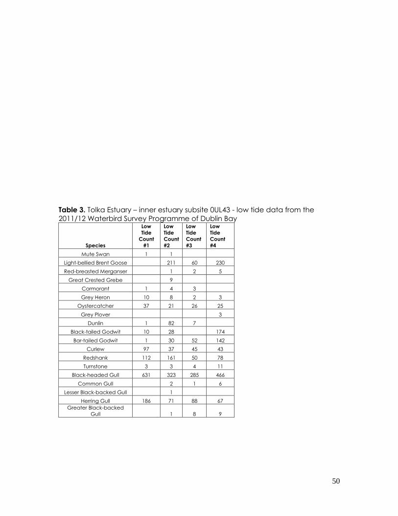
50
Table 3. Tolka Estuary – inner estuary subsite 0UL43 - low tide data from the
2011/12 Waterbird Survey Programme of Dublin Bay
Species
Low
Tide
Count
#1
Low
Tide
Count
#2
Low
Tide
Count
#3
Low
Tide
Count
#4 Mute Swan 1 1
Light-bellied Brent Goose 211 60 230
Red-breasted Merganser 1 2 5
Great Crested Grebe 9
Cormorant 1 4 3
Grey Heron 10 8 2 3
Oystercatcher 37 21 26 25
Grey Plover 3
Dunlin 1 82 7
Black-tailed Godwit 10 28 174
Bar-tailed Godwit 1 30 52 142
Curlew 97 37 45 43
Redshank 112 161 50 78
Turnstone 3 3 4 11
Black-headed Gull 631 323 285 466
Common Gull 2 1 6
Lesser Black-backed Gull 1
Herring Gull 186 71 88 67
Greater Black-backed
Gull 1 8 9
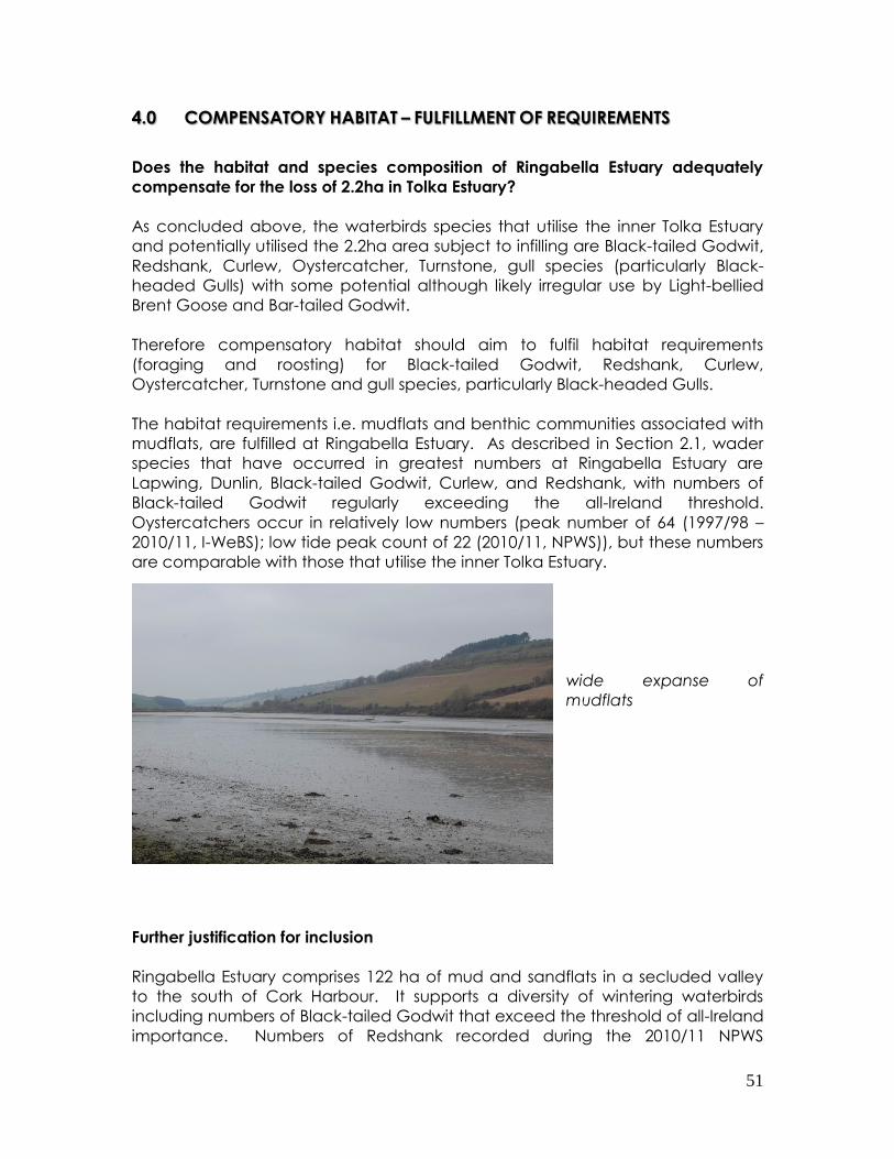
51
4.0 COMPENSATORY HABITAT – FULFILLMENT OF REQUIREMENTS
Does the habitat and species composition of Ringabella Estuary adequately
compensate for the loss of 2.2ha in Tolka Estuary?
As concluded above, the waterbirds species that utilise the inner Tolka Estuary
and potentially utilised the 2.2ha area subject to infilling are Black-tailed Godwit,
Redshank, Curlew, Oystercatcher, Turnstone, gull species (particularly Black-
headed Gulls) with some potential although likely irregular use by Light-bellied
Brent Goose and Bar-tailed Godwit.
Therefore compensatory habitat should aim to fulfil habitat requirements
(foraging and roosting) for Black-tailed Godwit, Redshank, Curlew,
Oystercatcher, Turnstone and gull species, particularly Black-headed Gulls.
The habitat requirements i.e. mudflats and benthic communities associated with
mudflats, are fulfilled at Ringabella Estuary. As described in Section 2.1, wader
species that have occurred in greatest numbers at Ringabella Estuary are
Lapwing, Dunlin, Black-tailed Godwit, Curlew, and Redshank, with numbers of
Black-tailed Godwit regularly exceeding the all-Ireland threshold.
Oystercatchers occur in relatively low numbers (peak number of 64 (1997/98 –
2010/11, I-WeBS); low tide peak count of 22 (2010/11, NPWS)), but these numbers
are comparable with those that utilise the inner Tolka Estuary.
wide expanse of
mudflats
Further justification for inclusion
Ringabella Estuary comprises 122 ha of mud and sandflats in a secluded valley
to the south of Cork Harbour. It supports a diversity of wintering waterbirds
including numbers of Black-tailed Godwit that exceed the threshold of all-Ireland
importance. Numbers of Redshank recorded during the 2010/11 NPWS

52
Waterbird Survey Programme equate to a peak density of 0.8 Redshank ha-1,
which is a relatively high density (e.g. the whole site average intertidal foraging
density of Redshank at Dublin Bay which occurs in internationally important
numbers, is 0.5 Redshank ha-1). The waterbird community recorded at
Ringabella Estuary is considered typical for a river-valley estuary that exhibits a
gradient of fine muds to coarser sediments at the estuary mouth. The estuary is
currently counted as part of I-WeBS and is accessible and relatively easy to
monitor during both high and low tide periods.
Overall, in terms of habitat and waterbird species use, Ringabella Estuary
appears to fulfil the necessary criteria for inclusion in the SPA network as a
compensatory measure for the loss of 2.2 ha in the Tolka Estuary.
53
5.0 LINK WITH CORK HARBOUR SPA
Ringabella Estuary can be considered to be ecologically connected to Cork
Harbour and it is thought that birds that use this estuary are likely to distribute
across the wider sections of the Cork Harbour complex. This is confirmed by the
sightings of colour-ringed Black-tailed Godwits at Ringabella Estuary that have
also been observed at Lough Beg in Cork Harbour.
Should Ringabella Estuary be progressed to the designation stage it would be
appropriate that the protective regime that is framed by Cork Harbour SPA is
extended to this new subsite.
Cork Harbour SPA is currently listed for the following species: Little Grebe
Great Crested Grebe
Cormorant
Grey Heron
Shelduck
Wigeon
Teal
Pintail
Shoveler
Red-breasted Merganser
Oystercatcher
Golden Plover
Grey Plover
Lapwing
Dunlin
Black-tailed Godwit
Bar-tailed Godwit
Curlew
Redshank
Black-headed Gull
Common Gull
Lesser Black-backed Gull
Common Tern
The protective regime associated with these aforementioned species (or any
future change to the listed species of Cork Harbour SPA) should then be
extended to the Ringabella Estuary subsite.
Cork Harbour SPA is also listed for its wetland habitat in its own right as a resource
for the regularly-occurring migratory waterbirds that utilise it. It would therefore
follow that the extent of the wetland habitat contained with the Ringabella
Estuary subsite be incorporated into the overall listed wetland extent of Cork
Harbour SPA.
As this area is regularly counted as part of the larger Cork Harbour complex
through I-WeBS there should be no significant increase in the effort required to
monitor the constituent birds if it was designated as an SPA.
54
6.0 REFERENCES
Connor, D. W., Allen, J. H., Golding, N., Howell, K. L., Lieberknecht, L. M., Northern,
K. O. and Reker, J. B. (2004) The Marine habitat classification for Britain and
Ireland. Version 04.05. JNCC, Peterborough, UK.
www.jncc.gov.uk/MarineHabitatClassification
Crowe, O. & Holt, C. (2013) Estimates of waterbird numbers wintering in Ireland
2006/07 – 2010/11. Irish Birds 9, 545-552.
Nairn, R. (2013) Winter Bird Surveys in Dublin Port and Tolka Estuary, 2009/10 to
2012/13. Report to Dublin Port Company. Natura Environmental Consultants.
Wicklow.
NPWS (2012) Site Synopsis - South Dublin Bay and River Tolka Estuary SPA (Site
Code 4024) National Parks & Wildlife Service. 2012.
NPWS (2013) South Dublin Bay SAC (Site Code 0210). Conservation objectives
supporting document – marine habitats. Version 1. July 2013.
Ravenscroft, N. O. M. & Beardall, C. H. (2003) The importance of freshwater flows
over estuarine mudflats for wintering waders and wildfowl. Biological
Conservation 113, 89-97.
55
ANNEX 1 – BOUNDARY MAPPING
Ringabella Bay Site Boundary
B11 (N1) – other boundary, edge of pavement that runs along the upper shore;
B12 (N2) – unmarked boundary, unmarked gap between pavement and wall
(slip);
B12 (N3) - unmarked boundary, unmarked gap between pavement and wall;
B4 – wall;
B4/B11 (N4) – wall/rock armour;
B11 (N5) – high water mark. Shoreline is ‘messy’ although walls and linear features
in places, these are not consistent so no continual boundary is present; HWM
considered the best;
B12 (N6) – unmarked boundary, unmarked gap due to a slip;
B1 – hedge;
B2 – treeline;
B11/B2 – take as high water mark or line of vegetation;
B12 (N7) - unmarked boundary across road;
B11 (N8) – HWM, cliff-lined shoreline;
B2/B4 (N9) – sea wall and treeline, where there are gaps in the seawall, use
treeline;
B11 (N10) – unmarked boundary take HWM;
B11 (N11) – embankment/barrage. Likely has a stone interior but is a grassy
embankment for much of its length.

56
57
58
59

60
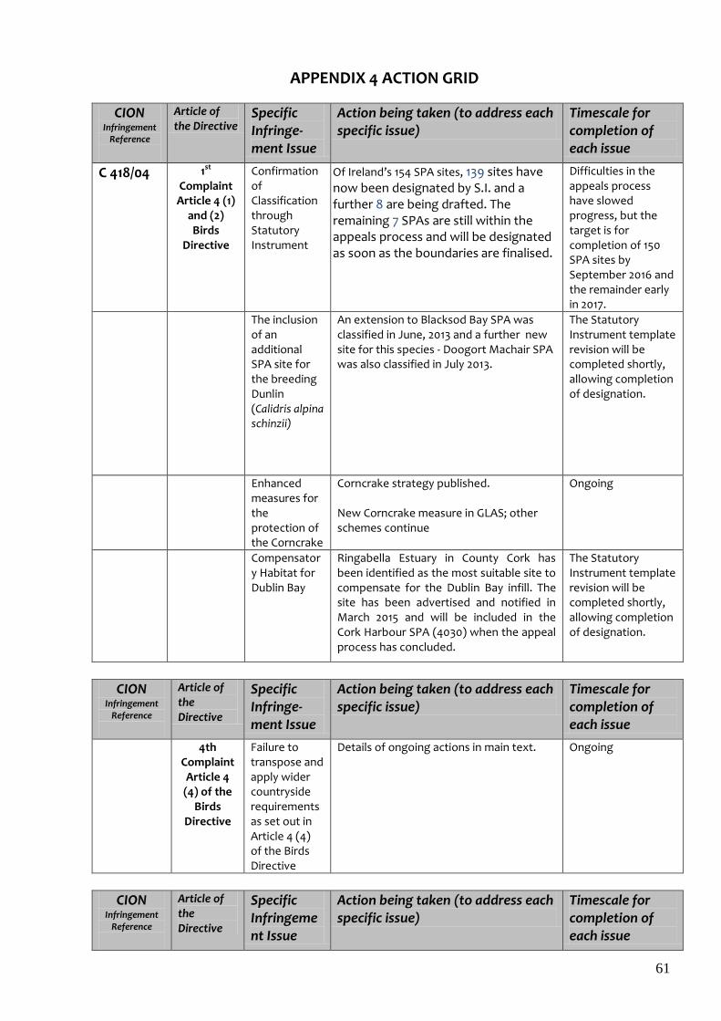
61
APPENDIX 4 ACTION GRID
CION Infringement
Reference
Article of the Directive
Specific Infringe-ment Issue
Action being taken (to address each specific issue)
Timescale for completion of each issue
C 418/04 1st Complaint Article 4 (1)
and (2) Birds
Directive
Confirmation of Classification through Statutory Instrument
Of Ireland’s 154 SPA sites, 139 sites have now been designated by S.I. and a further 8 are being drafted. The remaining 7 SPAs are still within the appeals process and will be designated as soon as the boundaries are finalised.
Difficulties in the appeals process have slowed progress, but the target is for completion of 150 SPA sites by September 2016 and the remainder early in 2017.
The inclusion of an additional SPA site for the breeding Dunlin (Calidris alpina schinzii)
An extension to Blacksod Bay SPA was classified in June, 2013 and a further new site for this species - Doogort Machair SPA was also classified in July 2013.
The Statutory Instrument template revision will be completed shortly, allowing completion of designation.
Enhanced measures for the protection of the Corncrake
Corncrake strategy published. New Corncrake measure in GLAS; other schemes continue
Ongoing
Compensatory Habitat for Dublin Bay
Ringabella Estuary in County Cork has been identified as the most suitable site to compensate for the Dublin Bay infill. The site has been advertised and notified in March 2015 and will be included in the Cork Harbour SPA (4030) when the appeal process has concluded.
The Statutory Instrument template revision will be completed shortly, allowing completion of designation.
CION Infringement
Reference
Article of the Directive
Specific Infringe-ment Issue
Action being taken (to address each specific issue)
Timescale for completion of each issue
4th Complaint Article 4 (4) of the
Birds Directive
Failure to transpose and apply wider countryside requirements as set out in Article 4 (4) of the Birds Directive
Details of ongoing actions in main text.
Ongoing
CION Infringement
Reference
Article of the Directive
Specific Infringement Issue
Action being taken (to address each specific issue)
Timescale for completion of each issue

62
5th Complaint
Article 6(2)-(4) of
the Habitats Directive
Failure to ensure appropriate assessment of aquaculture projects
See Appendix 5 for details
Detailed data collection in 91 Bays/Estuaries
Detailed analysis of raw data collected
Setting Conservation Objectives to be met in each site
Carrying out Appropriate Assessments of each licence application/fishery plan against the detailed Conservation Objectives set
Determination of Licences/Fisheries on the basis of the AA & other relevant factors
Detail and updated work programme provided in Appendix 5
63
Appendix 5: Management of Fisheries and Aquaculture Activities in Natura 2000 sites in Ireland
Progress update, April 2017. (Note: new text is in red)
Background Since 2009 Ireland has, with the agreement of the Commission, been working on bringing its aquaculture and fisheries in Natura 2000 sites into full compliance with the Habitats and Birds Directives in order to comply with the decision of the European Court of Justice in case C418/04. Ireland’s work programme for this objective is defined in the 2009 document - A Roadmap towards the Management of Fisheries and Aquaculture Activities in Natura 2000 sites in Ireland. The document identified 3 key elements i.e. Technical, Policy & Regulation and Interim Arrangements as part of the Roadmap to Compliance. This document provides an update on the progress made to date on each of these elements. The document headings reflect the sequence of steps involved in the implementation of Article 6 at each designated site from the initial step of collection of baseline ecological data for setting of conservation objectives, the profiling of industry activity, development of fishery plans, research to support assessment of significant effects, appropriate assessment (art 6.3) and risk assessment (art 6.2), the consultation process, legislation to implement findings of assessments and enhanced ecological and regulatory monitoring where required. The Roadmap The main deliverable identified in the roadmap was the production of Appropriate Assessments for Article 6.3 of the Habitats Directive of Fisheries and Aquaculture activities in Natura 2000 sites in Ireland. This document follows the following structure:
1. Programme of collection of benthic data on Natura 2000 sites Programme of collection of data in SPAs on habitat use by waterbirds
2. Setting of Conservation objectives 3. Research to support AA, risk assessment and recommendations 4. Aquaculture
Framework legislation Procedures operated in relation to aquaculture licensing Profiling of industry activity Appropriate Assessments Consultation process Policy and regulation following assessment Enhanced regulatory monitoring Work programme
5. Fisheries Framework legislation Procedures operated in relation to sea-fisheries in Natura 2000

64
Profiling of industry activity Article 6 assessments Consultation and publication of information Licensing following appropriate assessment Monitoring and control following licensing Work programme 2013-2015
6. Post Assessment Monitoring Activities
Annex 1: Appropriate Assessment and Risk Assessment of Sea-Fisheries Annex 2: List of baseline benthic surveys in SACs and SPAs

65
1. Programme of collection of benthic data on in Natura 2000 sites
Surveys were carried out in SACs designated for intertidal mudflats and sandflats, large shallow inlets and bays, estuaries, reefs and sea caves as well as in SPAs designated for wading water birds and for scoter populations. The purpose of these data collection exercises was to provide baseline information on species and habitat extent within the feature of interest. These data are in turn used to generate Conservation Objectives for the features present within the Natura site. The programme of data collection is complete. All data has been submitted to the Marine Institute and following internal QA/QC and validation it is transferred to NPWS who use it to set Conservation Objectives. The list of sites with completed surveys and their status is provided in Annex 2.
Programme of collection of data in SPAs on habitat use by water birds This involved collection of low tide count data that provided spatial information on habitat use by birds. In addition the annual high tide roost counts (iWeBs) were continued at all SPAs. Fieldwork for all of the relevant sites (i.e. primarily intertidal sites designated for non-breeding waterbirds) has now been completed by the baseline survey team (Table 1).
Table 1. SPAs where low tide counts of waterbirds were completed
Site Code Site name Winter
800004075 LOUGH SWILLY 2009/2010
800004029 CASTLEMAINE HARBOUR 2009/2010
800004032 DUNGARVAN HARBOUR 2009/2010
800004026 DUNDALK BAY 2009/2010
800004076
WEXFORD HARBOUR AND SLOBS (incl RAVEN
4019) 2009/2010
800004031 INNER GALWAY BAY 2009/2010
800004033 BANNOW BAY 2009/2010
800004034 TRAWBREAGA BAY 2009/2010
800004151 DONEGAL BAY 2009/2010
800004188 TRALEE BAY COMPLEX 2009/2010
800004037 BLACKSOD BAY/BROADHAVEN 2009/2010
800004028 BLACKWATER ESTUARY 2009/2010
800004020 BALLYTEIGUE BURROW 2011/2012
800004022 BALLYCOTTON BAY 2010/2011
800004023 BALLYMACODA BAY 2010/2011
800004081 CLONAKILTY BAY 2010/2011
800004027 TRAMORE BACK STRAND 2010/2011
800004030 CORK HARBOUR 2010/2011
800004077
RIVER SHANNON AND RIVER FERGUS
ESTUARIES 2010/2011
800004219 COURTMACSHERRY BAY 2010/2011
800004182 MID CLARE COAST 2010/2011
800004013 DRUMCLIFF BAY 2010/2011
800004035 CUMMEEN STRAND 2010/2011
800004036 KILLALA BAY/MOY ESTUARY 2010/2011
800004078 CARLINGFORD LOUGH 2010/2011
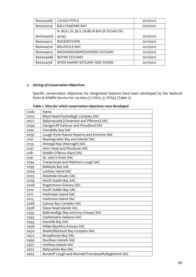
66
800004087 LOUGH FOYLE 2011/2012
800004129 BALLYSADARE BAY 2010/2011
800004006
N. BULL IS. (& S. DUBLIN BAY,R.TOLKA EST.
4024) 2011/2012
800004015 ROGERSTOWN 2011/2012
800004016 BALDOYLE BAY 2011/2012
800004025 BROADMEADOW/SWORDS ESTUARY 2011/2012
800004080 BOYNE ESTUARY 2011/2012
800004158 RIVER NANNY ESTUARY AND SHORE - 2011/2012
2. Setting of Conservation Objectives
Specific conservation objectives for designated features have been developed by the National Parks & Wildlife Service for 114 sites (77 SACs; 37 SPAs). (Table 2).
Table 2. Sites for which conservation objectives were developed
Code Name
0020 Black Head-Poulsallagh Complex SAC
0077 Ballymacoda (Clonpriest and Pillmore) SAC
0090 Glengarriff Harbour and Woodland SAC
0091 Clonakilty Bay SAC
0097 Lough Hyne Nature Reserve and Environs SAC
0101 Roaringwater Bay and Islands SAC
0133 Donegal Bay (Murvagh) SAC
0147 Horn Head and Rinclevan SAC
0181 Rathlin O’Birne Island SAC
0191 St. John’s Point SAC
0194 Tranarossan and Melmore Lough SAC
0199 Baldoyle Bay SAC
0204 Lambay Island SAC
0205 Malahide Estuary SAC
0206 North Dublin Bay SAC
0208 Rogerstown Estuary SAC
0210 South Dublin Bay SAC
0212 Inishmaan Island SAC
0213 Inishmore Island SAC
0268 Galway Bay Complex SAC
0328 Slyne Head Islands SAC
0335 Ballinskelligs Bay and Inny Estuary SAC
0343 Castlemaine Harbour SAC
0455 Dundalk Bay SAC
0458 Killala Bay/Moy Estuary SAC
0470 Mullet/Blacksod Bay Complex SAC
0472 Broadhaven Bay SAC
0495 Duvillaun Islands SAC
0507 Inishkea Islands SAC
0622 Ballysadare Bay SAC
0625 Bunduff Lough and Machair/Trawalua/Mullaghmore SAC
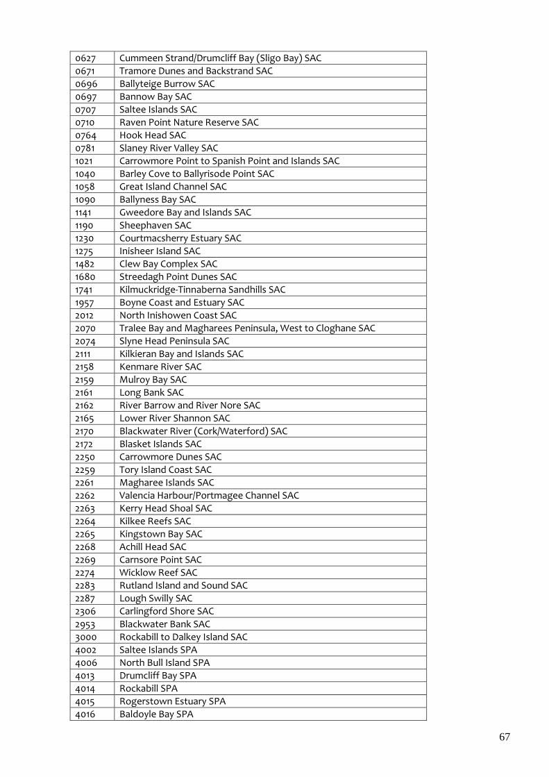
67
0627 Cummeen Strand/Drumcliff Bay (Sligo Bay) SAC
0671 Tramore Dunes and Backstrand SAC
0696 Ballyteige Burrow SAC
0697 Bannow Bay SAC
0707 Saltee Islands SAC
0710 Raven Point Nature Reserve SAC
0764 Hook Head SAC
0781 Slaney River Valley SAC
1021 Carrowmore Point to Spanish Point and Islands SAC
1040 Barley Cove to Ballyrisode Point SAC
1058 Great Island Channel SAC
1090 Ballyness Bay SAC
1141 Gweedore Bay and Islands SAC
1190 Sheephaven SAC
1230 Courtmacsherry Estuary SAC
1275 Inisheer Island SAC
1482 Clew Bay Complex SAC
1680 Streedagh Point Dunes SAC
1741 Kilmuckridge-Tinnaberna Sandhills SAC
1957 Boyne Coast and Estuary SAC
2012 North Inishowen Coast SAC
2070 Tralee Bay and Magharees Peninsula, West to Cloghane SAC
2074 Slyne Head Peninsula SAC
2111 Kilkieran Bay and Islands SAC
2158 Kenmare River SAC
2159 Mulroy Bay SAC
2161 Long Bank SAC
2162 River Barrow and River Nore SAC
2165 Lower River Shannon SAC
2170 Blackwater River (Cork/Waterford) SAC
2172 Blasket Islands SAC
2250 Carrowmore Dunes SAC
2259 Tory Island Coast SAC
2261 Magharee Islands SAC
2262 Valencia Harbour/Portmagee Channel SAC
2263 Kerry Head Shoal SAC
2264 Kilkee Reefs SAC
2265 Kingstown Bay SAC
2268 Achill Head SAC
2269 Carnsore Point SAC
2274 Wicklow Reef SAC
2283 Rutland Island and Sound SAC
2287 Lough Swilly SAC
2306 Carlingford Shore SAC
2953 Blackwater Bank SAC
3000 Rockabill to Dalkey Island SAC
4002 Saltee Islands SPA
4006 North Bull Island SPA
4013 Drumcliff Bay SPA
4014 Rockabill SPA
4015 Rogerstown Estuary SPA
4016 Baldoyle Bay SPA
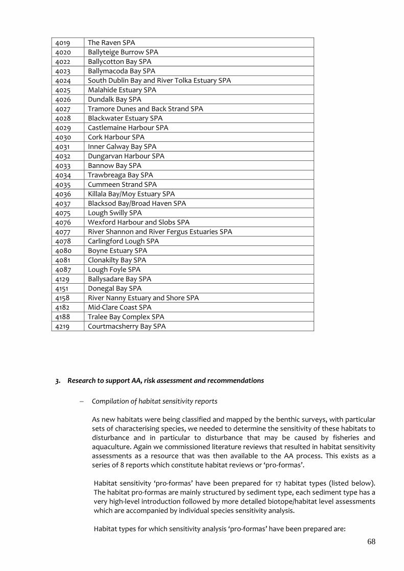
68
4019 The Raven SPA
4020 Ballyteige Burrow SPA
4022 Ballycotton Bay SPA
4023 Ballymacoda Bay SPA
4024 South Dublin Bay and River Tolka Estuary SPA
4025 Malahide Estuary SPA
4026 Dundalk Bay SPA
4027 Tramore Dunes and Back Strand SPA
4028 Blackwater Estuary SPA
4029 Castlemaine Harbour SPA
4030 Cork Harbour SPA
4031 Inner Galway Bay SPA
4032 Dungarvan Harbour SPA
4033 Bannow Bay SPA
4034 Trawbreaga Bay SPA
4035 Cummeen Strand SPA
4036 Killala Bay/Moy Estuary SPA
4037 Blacksod Bay/Broad Haven SPA
4075 Lough Swilly SPA
4076 Wexford Harbour and Slobs SPA
4077 River Shannon and River Fergus Estuaries SPA
4078 Carlingford Lough SPA
4080 Boyne Estuary SPA
4081 Clonakilty Bay SPA
4087 Lough Foyle SPA
4129 Ballysadare Bay SPA
4151 Donegal Bay SPA
4158 River Nanny Estuary and Shore SPA
4182 Mid-Clare Coast SPA
4188 Tralee Bay Complex SPA
4219 Courtmacsherry Bay SPA
3. Research to support AA, risk assessment and recommendations
Compilation of habitat sensitivity reports As new habitats were being classified and mapped by the benthic surveys, with particular sets of characterising species, we needed to determine the sensitivity of these habitats to disturbance and in particular to disturbance that may be caused by fisheries and aquaculture. Again we commissioned literature reviews that resulted in habitat sensitivity assessments as a resource that was then available to the AA process. This exists as a series of 8 reports which constitute habitat reviews or ‘pro-formas’. Habitat sensitivity ‘pro-formas’ have been prepared for 17 habitat types (listed below). The habitat pro-formas are mainly structured by sediment type, each sediment type has a very high-level introduction followed by more detailed biotope/habitat level assessments which are accompanied by individual species sensitivity analysis.
Habitat types for which sensitivity analysis ‘pro-formas’ have been prepared are:
69
1. Muddy sand -sublittoral 2. Fine sand -littoral 3. Muddy sand -littoral 4. Fine sand -sublittoral 5. Mixed sediment –sublittoral (coarse) 6. Mud -littoral 7. Mixed sediment -littoral 8. Mixed sediment –sublittoral (polychaetes and bivalves) 9. Saltmarsh 10. Reef –littoral (exposed) 11. Reef-littoral (sheltered) 12. Reef-sublittoral (exposed) 13. Maerl 14. Zostera 15. Ostrea edulis dominated community 16. Reef-subtidal (sheltered) 17. Reef-sublittoral (Laminaria dominated-exposed)
The habitat pro-formas are produced as a series of 8 reports. These are available to view or download from the open access repository of the Marine Institute library (http://oar.marine.ie/)
New research to support AA process where necessary Prior to beginning the AA process at particular sites, and using the industry activity profiles, we identified activity-habitat-species interactions for which there were no suitable scientific data to support evaluation of significance in the AA process. Where information for such assessment was completely lacking in the literature i.e. no case studies, we commissioned original research. This was mainly in relation to the potential disturbance of aquaculture activity, such as oyster culture, which is a widespread activity, and intertidal mussel relaying on bird habitat use. Notable outputs of this research include
Study of waterbird use of the intertidal mussel nursery area at Castlemaine Harbour, which was undertaken to examine the effect of an intertidal mussel fishery on waterbird utilisation of intertidal habitat in Castlemaine Harbour. Results of this study are available at http://www.fishingnet.ie/media/fishingnet/content/fisheriesinnaturaareas/fisheriesnaturaplanconsultations/Annex_V_%20Mussels_Gittings_and_ODonohue_2011a.pdf
Strategic study of the relationship between waterbird distribution and oyster trestles, the aim of which was to identify consistent patterns across sites of associations between waterbird distribution and the presence of oyster trestles on the shore. This study was carried out a 6 sites including Bannow Bay, Co, Wexford; Waterford Harbour & Dungarvan, Co. Waterford; Ballymacoda, Co. Cork; Castlemaine, Co. Kerry; and Poulnasherry, Co. Clare. A more detailed study of the relationship between waterbird distribution and oyster trestles was carried out in Dungarvan Harbour. Results of these studies are available in Gittings & O’Donoghue (March 2012). The effects of intertidal oyster culture on the spatial distribution of waterbirds. Unpublished report for the Marine Institute. An abridged version of this report has been accepted for publication in Wader Study (Journal of International Wader Study Group).
70
Effects of oyster trestles on marine benthos. A study is ongoing whereby benthic infauna will be estimated in and around the structures used for intertidal oyster culture. The study is designed to delineate the extent of the impact of the activities (i.e. trestles and access mechanisms – tractors) on infaunal biota. These data will be compared with control locations reflective of similar habitats yet away from any likely impact. The goal of the study is to inform assessment of intertidal oyster culture activities and provide increased certainty in the conclusions drawn. This study is completed and has been published in the Marine Pollution Bulletin - http://dx.doi.org/10.1016/j.marpolbul.2015.04.013. A second study was undertaken as a follow-on from the first, whereby the effects of severe weather events (during winter 2013/2014) on habitats in the vicinity of oyster trestles were assessed. It concluded that while the weather events did impact on habitats, it was not sufficient to neutralise the impact/disturbance of access routes on habitats. This study was submitted to the Marine Pollution Bulletin 1. O’Carroll J, Quinn C, Forde J, Patterson A, O’Beirn F.X, Kennedy R. 2016. Impact of prolonged storm activity on the Ecological Status of intertidal benthic habitats within oyster (Crassostrea gigas) trestle cultivation sites. Marine Pollution Bulletin. 110: 460–469
4. Aquaculture
Framework Legislation The obligation to undertake Appropriate Assessment (AA) derives from Article 6(3) of the Habitats Directive. The Habitats Directive is transposed in Ireland in the European Communities (Birds and Natural Habitats) Regulations 2011 (SI No. 477 of 2011) and this legislation is utilised to determine whether screening for AA or a full AA is required in a Natura or adjacent site. In broader terms, the carrying out of aquaculture is regulated by the Fisheries (Amendment) Act 1997. The licensing authority (i.e. the Minister, an officer to whom functions have been delegated by the Minister, or the Aquaculture Licence Appeals Boards) may, if it is satisfied to do so, license a person, at a place or in waters specified in the licence, to engage in aquaculture or such operations in relation to aquaculture, and subject to such conditions, as it thinks fit and specifies in the licence. The Minister for Agriculture, Food and the Marine has two distinct roles in respect of aquaculture: (i) A general policy role – the Minister can issue general policy directives under section 62 of the Fisheries (Amendment) Act, 1997 (ii) A regulatory role – making determinations in respect of aquaculture licence applications. In accordance with regulation 5.2 of SI No. 236 of 1998 the Minister may require the applicant, in relation to each individual aquaculture licence application, to submit an Environmental Impact Statement (EIS) if the Minister considers that the proposed aquaculture is likely to have significant effects on the environment. The Minister’s determination as to whether or not an EIS is required is published on the Department’s website. The Foreshore Act 1933, for which the Minister has power to grant leases / licences, regulates the placement of structures on the foreshore associated with the carrying out of licensed aquaculture. Licensees, whose licences have expired, but who have applied for renewal of their aquaculture licences have their continued aquaculture operations authorised by section 19A (4) of the Fisheries (Amendment) Act 1997. This allows aquaculturists, who have submitted valid renewal applications, to continue aquaculture activities, subject to the terms and conditions of their old licences, pending a decision on their renewal applications. The significant work involved in
71
implementing the Appropriate Assessment process has resulted in delays in the aquaculture licensing process with the result that a significant element of the industry is now relying on this section of the Act. However, the Irish authorities are committed to repealing section 19A (4) following the completion of the agreed ‘Roadmap’ process, thus ensuring that all aquaculture will be licensed in accordance with the requirements of the Birds and Habitats Directives. Procedures operated in relation to Aquaculture Licensing The procedural steps relating to aquaculture licensing, including public and statutory consultation, are set out in SI No. 236 of 1998 – Aquaculture (Licence Application) Regulations, 1998. Notice of aquaculture licence applications are published in a newspaper circulating in the vicinity of the proposed aquaculture. This notice specifies where the documentation relating to the application may be inspected. A person may make written submissions or observations within a prescribed time period (as set out in the Statutory Instrument). In addition, aquaculture licence applications are sent to statutory consultees (as prescribed in regulation 10 of SI No. 236 of 1998). These procedures are illustrated below:
Step 1 Aquaculture licence application received.
Step 2 Application checked – if location in or adjacent to Natura 2000 area, sent for Appropriate Assessment
Step 3 Appropriate Assessment carried out by the Marine Institute (Department’s scientific advisors) following the setting out of the conservation objectives by the National Parks and Wildlife Service (NPWS)
Step 4 On receipt of the Appropriate Assessment (AA) the Department in conjunction with its scientific and technical advisors carries out an Environmental Impact Assessment (EIA) screening to ensure compliance with EU Environmental Directives (for some aquaculture activities, e.g. marine finish, an EIS is compulsory)
Step 5 Submission of set of policy recommendations for entire bay/Natura site for Ministerial approval
Step 6(a) All applications accompanied by the Appropriate Assessment and EIA screening (or EIS) are sent to Statutory Consultees (this includes NPWS, An Taisce, County Councils, Department of Environment etc)
Step 6(b) All applications accompanied by the Appropriate Assessment and EIA screening (or EIS are sent to Public consultation - allowing members of the public to comment
Step 7 All information received is evaluated by Department Officials and a recommendation made to the Minister
Step 8 Ministerial Decision to either grant or refuse the application
Step 9 Publication of Ministerial Decision
Step 10 Decision may be appealed to the Aquaculture Licences Appeals Board (ALAB) - the independent appeals body
Step 11 Aquaculture Licences Appeals Board (ALAB) publish their decision
72
(Aquaculture Licences Appeals Board (ALAB) decision can be judicially reviewed).
Profiling of industry activity Although in the case of aquaculture the list of licences and applications in each site is known, details of the actual activities at each site, such as access routes, species in production, level of production and spatial use of the site were profiled for each licence holder to inform the AA process. Profiling of aquaculture has been completed in
Dundalk Bay
Castlemaine Harbour and inner Dingle Bay
Roaringwater Bay
Lough Swilly
Donegal Bay
Clew Bay
Galway Bay
Dungarvan Harbour
Valentia / Portmagee Channel
Tralee Bay
Kenmare River
Trawbreaga Bay
Wexford Harbour
Ballycotton Bay
Lower River Shannon
Cummeen Strand / Drumcliff Bay
Blacksod / Broadhaven Bays
Mulroy Bay
Sheephaven
Bannow Bay
Ballymacoda
Gweedore Bay and Islands
Slyne Head Peninsula (Mannin Bay)
Kilkieran Bay
Waterford Harbour
West of Ardara – Maas Road
Appropriate Assessments As the roadmap indicated, aquaculture operations were to be assessed under Article 6.3 (appropriate assessment).
The current situation is as follows:
Dundalk Bay (2 Natura sites) ( 2011) http://www.fishingnet.ie/fisheriesinnaturaareas/sitessubjectedtoappropriateassessmentriskassessment/dundalkbay/ Dundalk Bay primarily covers wild fisheries, for example, cockles and is dealt with under the “Fisheries segment” of the Programme of Measures.
73
Castlemaine Harbour (2 Natura sites) (2011) http://www.fishingnet.ie/fisheriesinnaturaareas/sitessubjectedtoappropriateassessmentriskassessment/castlemaineharbour The Appropriate Assessment process and 43 aquaculture licensing determinations (based on the applications available at the time of assessment) have been completed for Castlemaine Harbour. A significant number of new applications have been received by the Department since the carrying out of the Appropriate Assessment which will require a further Appropriate Assessment.
Roaringwater Bay (1 Natura site) (2013) http://www.agriculture.gov.ie/media/migration/fisheries/aquacultureforeshoremanagement/aquaculturelicensing/RoaringWaterBayAssessment011013.pdf The Appropriate Assessment process and including final licence determinations have been completed for Roaringwater Bay (74 licensing determinations). Licensing in this bay is now regarded as complete, subject to the receipt of new licence applications.
Lough Swilly (2 Natura sites) (2013) http://www.agriculture.gov.ie/fisheries/aquacultureforeshoremanagement/aquaculturelicensing/appropriateassessmentscarriedout/ The examination, analysis, evaluation and findings phase of the Appropriate Assessment for Lough Swilly has been completed, but final licensing determinations have yet to be made (underwater archaeological issues). The Department has prepared an Appropriate Assessment Conclusion Statement outlining how it is proposed to licence aquaculture in this Natura site in compliance with the Birds/Habitats Directives (available on the Department’s website). The footprint of the aquaculture is being significantly reduced.
Donegal Bay (3 Natura sites) (2013) http://www.fishingnet.ie/fisheriesinnaturaareas/sitessubjectedtoappropriateassessmentriskassessme
nt/donegalbay
The Appropriate Assessment process and final aquaculture licensing determinations have been completed for Donegal Bay in respect of the majority of the applications. The Department has prepared an Appropriate Assessment Conclusion Statement outlining how it is proposed to licence aquaculture in this Natura site in compliance with the Birds/Habitats Directives (available on the Department’s website). Additional data collection and monitoring was necessary in respect of the outstanding applications. The monitoring update (available on the Department’s website) has been evaluated by the Department and licensing decisions have been made based on its findings.
Dungarvan Harbour http://www.agriculture.gov.ie/fisheries/aquacultureforeshoremanagement/aquaculturelicensing/appropriateassessmentscarriedout/ The Appropriate Assessment for Dungarvan Harbour has been completed; subsequently, a
tidal cycle monitoring of water bird numbers and distribution was carried out in 2014/2015.
The Department has prepared an Appropriate Assessment Conclusion Statement outlining
how aquaculture is being licensed in this Natura site in compliance with the Birds Directive
(available on the Department’s website). Licensing has been completed for this SPA.
Clew Bay
74
http://www.agriculture.gov.ie/fisheries/aquacultureforeshoremanagement/aquaculturelicensing/appropriateassessmentscarriedout/ The Appropriate Assessment process including licence determinations have been completed in respect of Clew Bay.
Valentia / Portmagee Channel
http://www.agriculture.gov.ie/fisheries/aquacultureforeshoremanagement/aquaculturelicensing/appropriateassessmentscarriedout/ The Appropriate Assessment for Valentia/Portmagee Channel has been received and a Conclusion Statement has been prepared outlining how it is proposed to licence and manage aquaculture activities in this Natura site and is available on the Departments website. A number of licensing decisions have been made.
Ballycotton Bay http://www.agriculture.gov.ie/fisheries/aquacultureforeshoremanagement/aquaculturelicensing/appropriateassessmentscarriedout/ The Appropriate Assessment report has been completed for Ballycotton. There is no existing aquaculture in the Bay. The Appropriate Assessment report found that the proposed aquaculture would be likely to have significant effects on the protected species of this Natura Site.
Galway Bay http://www.agriculture.gov.ie/fisheries/aquacultureforeshoremanagement/aquaculturelicensing/appropriateassessmentscarriedout/ The Appropriate Assessment report for Galway Bay has been completed and a Conclusion Statement has been prepared outlining how it is proposed to licence and manage aquaculture activities in this Natura site and is available on the Departments website. Licensing determinations have been made.
Kenmare Bay http://www.agriculture.gov.ie/fisheries/aquacultureforeshoremanagement/aquaculturelicensing/appropriateassessmentscarriedout/ The Appropriate Assessment report for Kenmare Bay has been received and a Conclusion Statement has been prepared outlining how it is proposed to licence and manage aquaculture activities in this Natura site and is available on the Department’s website.
Drumcliff Bay/Cummeen Harbour
http://www.agriculture.gov.ie/fisheries/aquacultureforeshoremanagement/aquaculturelicensing/appropriateassessmentscarriedout/cummeenstranddrumcliffbayappropriateassessment/ The Appropriate Assessment report has been completed and aquaculture licensing determinations have been completed for the majority of the aquaculture applications in Drumcliff Bay/ Cummeen Harbour. The Department has prepared an Appropriate Assessment Conclusion Statement outlining how it is licensing aquaculture in these Natura sites in compliance with the Birds/Habitats Directives (available on the Department’s website).
Kilkieran Bay
75
http://www.agriculture.gov.ie/media/migration/fisheries/aquacultureforeshoremanagement/aquaculturelicensing/appropriateassessments/KilkieranBayIslAppAss040316.pdf The Appropriate Assessment report has been completed and the findings are being examined by the Department.
Trawbreaga Bay (North Innishowen Coast SAC/Trawbreaga SPA). The Appropriate Assessment report has been completed and the findings are being examined by the Department. EIA screenings are in progress.
Gweedore Bay http://www.agriculture.gov.ie/media/migration/fisheries/aquacultureforeshoremanagement/aquaculturelicensing/appropriateassessments/GweedoreBayIslandsAAAquaFeb16220216.pdf The Appropriate Assessment report for Gweedore has been completed. A Conclusion Statement has been prepared outlining how it is proposed to licence and manage aquaculture activities in this Natura site and is available on the Departments website. Statutory and Public Consultation has been completed and a number of licensing determinations have been made.
Sheephaven SAC The Appropriate Assessment report has been completed and the and the findings are being examined by the Department.
Waterford Harbour (River Barrow and River Suir SAC) The Appropriate Assessment report has been completed out and the findings are being examined by the Department .
Wexford Harbour and Slobs SPA, The Raven SPA, Slaney River Valley SAC and Raven Point Nature Reserve SAC The Appropriate Assessment report has been completed and the findings are being examined by the Department.
West of Ardara/Maas Road SAC The Appropriate Assessment report has been completed and the findings are being examined by the Department.
Bannow Bay The Appropriate Assessment report has been completed and the findings are being examined by the Department
Mulroy Bay The Appropriate Assessment report has been completed and the findings are being examined by the Department and a conclusion statement is being prepared.
Slyne Head Peninsula (Mannin Bay) The Appropriate Assessment report has been completed and the findings are being examined by the Department
Blacksod and Broadhaven Bays The Appropriate Assessment report for has been completed and the findings are being examined by the Department
Loughros Beg Bay/Slieve Tooey/Tormor Is. SAC
76
The Appropriate Assessment screening report has been prepared and the findings are being examined by the Department
Consultation Process From an aquaculture perspective, the AA is based on a list of licensed aquaculture activities and applications. Consultation takes place with technical and scientific advisors with a view to transferring the AA findings into specific licence conditions. There is a formal public and statutory consultation for each individual application which is set out in legislation.
Policy and regulation following Appropriate Assessment
The next step in the process is the carrying out of Environmental Impact Screening (for some aquaculture operations e.g. marine finfish an Environmental Impact statement is compulsory). The Minister may require applicants to submit an Environmental Impact Statement if he considers that the proposed aquaculture is likely to have significant effects on the environment. The Ministerial determination, on whether an EIS is required or not, is published. This requirement (under EU EIA Directives) is separate from the Habitats requirements.
Each application goes to public and statutory consultation. Specific draft licence conditions are prepared taking account of the Appropriate Assessment (AA) carried out by the Marine Institute and other information such as that received in the public/statutory consultation phase, as well as additional technical observations. Licences contain a clear reference to the AA and the Natura 2000 interests. A Conclusion Statement is prepared by the ‘Licensing Authority’ (i.e. Minister for Agriculture, Food and the Marine) which outlines how aquaculture activities in the Natura site are being licensed in compliance with the Birds and Habitats Directives and is published on the Department’s website. The Licensing Authority has to be satisfied, given the conclusions and recommendations of the Appropriate Assessment process and, if required, the implementation of measures that will mitigate certain pressures on Natura features, that the proposed aquaculture licensed activities are not likely to have a significant effect on the integrity of the relevant Natura site. The Conclusion Statement outlines the timescale and mechanisms through which mitigation measures, as required, will be secured, implemented and monitored. Notwithstanding that the AA takes place on a Bay/Natura site basis, each aquaculture application is the subject of an individual recommendation to the Minister. In the case of a positive recommendation to the Minister, the draft licence incorporating the specific conditions is also sent for Ministerial approval. The Ministerial decisions are published in newspaper/s circulating in the area of the aquaculture. The relevant public notice also provides a link to the Department’s website, which outlines the reasons for the Minister’s decision in each individual case. To summarise, the following material is available in relation to all aquaculture licence decisions:
a) the general conditions attaching to all licences as set out in the licence templates which
are available on the Department’s website;
b) reasons for the Minister’s decision in individual cases which are also available on the
Department’s website;
77
c) Licensing Authority’s Appropriate Assessment Conclusion Statement which outlines how
aquaculture in the particular ‘Natura’ site/s is being licensed in accordance with the
requirements of the Birds/Habitats Directives (also on the Department’s website).
The publishing of the above material on the Department’s website provides information to enable an informed decision to be made on any possible appeal. This addresses the concerns raised in relation to the accessibility of documentation supporting the Minister’s decision in sufficient time to enable an appeal to be made to Aquaculture Licensing Appeals Board (ALAB).
The Ministerial decision may be appealed to ALAB. The function of the Board is to provide an independent authority for the determination of appeals against decisions of the Minister for Agriculture, Food and the Marine on aquaculture licence applications. A person aggrieved by a decision of the Minister on an aquaculture licence application, or by the revocation or amendment of an aquaculture licence, may make an appeal within one month of publication (in the case of a decision) or notification (in the case of revocation / amendment).
In addition, ALAB also publishes its decision. Decisions of the State are open to judicial review in the normal way. Marine fin fish and land based aquaculture licences are currently available online as part of the Department’s upgrading of its online provision of services in respect of all aquaculture licences. Measures are in place to make all other current aquaculture licences available online as soon as possible consistent with available resources. Enhanced regulatory monitoring A dedicated Monitoring and Compliance Unit has been established within the Department to strengthen the adherence to the terms and conditions of all Aquaculture Licences. The Unit brings greater coherence to the existing monitoring system leading to enhanced monitoring and regulatory standards, practices and procedures. A structure for the systematic audit of licence conditions has been put in place. This is a very substantial enhancement of the existing regulatory procedure and supplements all other inspections of sites. The Unit avails of services provided by representatives of DAFM, MI, Engineering Division (DAFM), SFPA, MSO and BIM as necessary. The areas targeted for audit include the following:-
Site:
Navigational marking
Location (within licenced boundaries)
Cleanliness/redundant structures
Access routes
Planning permissions (if appropriate)
Structures
Type of structure
Alignment
Moorings (if appropriate)
Spacing
Stocking and Records
Species and source
Stocking density

78
Stock movements
Fish health
Predator control
Chemical usage
Disposal of mortalities
Fallowing
Escapes
Environmental Monitoring
Water quality
Effluent discharge (if appropriate)
Chemical discharge
Benthic monitoring
Waste management
Emergency action plan
Specific Monitoring arising from Appropriate Assessment The Department of Agriculture, Food and the Marine together with the Marine Institute are actively identifying specific monitoring requirements in the context of the AA conclusions and licence conditions for Natura 2000 sites over and above ongoing monitoring. This is to ensure that issues of special priority identified in the AA are the subject of enhanced post-licensing monitoring and controls. Monitoring that is recommended in the Appropriate Assessment will take the form of a licence condition and will have the primary goal to provide additional certainty relating to the assessment conclusions. Monitoring is considered a mitigation measure as long as it is allied with specific and clear management measures. Any such monitoring protocols will be tailored to the specific issue at hand and will focus upon the likely interaction between the feature of interest (e.g. wading birds) and the activity licensed (e.g. oyster trestle culture). Furthermore, monitoring may take the form of capture of additional baseline information (e.g. Castlemaine) in order to provide a more robust data with which to estimate likely interactions (e.g. species displacement). The current situation is as follows:-
Ecological monitoring and additional research was recommended as a consequence of the
Castlemaine Appropriate Assessment process; these were translated into conditions in
Schedule 4 of the aquaculture licences. The circumstances that will invoke ecological (e.g.
bird) monitoring or the establishment of a monitoring framework at any of the aquaculture
sites has not been reached. Monitoring at Castlemaine will be invoked following a request to
exceed the 10% oyster trestle or 12% mussel seed cover by the aquaculture licence holder and
this request is granted. Site usage will then be monitored and if significant change in site
usage is realised, a bird monitoring / impact program will be initiated by the Marine Institute.
As part of the ongoing activities at the licensed aquaculture sites, the Monitoring and
Compliance Unit of DAFM and the MI are tasked to ensure that the operators are complying
with the 10% and 12% licence thresholds.
Additional research was also recommended in the Castlemaine Appropriate Assessment and
this was completed in 2012 and comprised studies at 6 oyster trestle locations (including
Castlemaine). The purpose of the study was to identify different bird species responses to
structures. Validation of the findings of the assessment in Castlemaine was an additional
79
output of this study. The output of a study focusing on the impact of oyster trestles on
habitats has been published in the Marine Pollution Bulletin -
http://dx.doi.org/10.1016/j.marpolbul.2015.04.013. This study was carried out at a range of
oyster growing areas with the view to determining the likely influence the structures have on
habitat features (species abundance, diversity as measured by composite indices). Similarly,
this study was initiated in order to provide certainty to the conclusions in this and other
assessments and validate the findings of other studies (these reports are referred to in the
Programme of Measures - April 2014).
In relation to Roaringwater Bay, there are no specific ecological monitoring requirements
relating to aquaculture activities.
Donegal Bay – During the Appropriate Assessment process it became apparent that
insufficient data was available on Sanderling abundance and site usage within the outer
portions of the SPA. In order to fully assess the sites, more accurate information relating to
Sanderling stocks at these sites was required. Five sub-sites were surveyed (Mountcharles,
Eddrim Estuary, Murvagh, Rossnowlagh, Aughrus Pt – Bundoran) with semi-monthly counts
of Sanderling throughout the intertidal area of Donegal Bay undertaken between September
2014 and February 2015. The data allows an updated assessment as to the likely interactions
between oyster trestle culture activity in the Mountcharles area and Sanderling. The
Department has prepared an Appropriate Assessment Conclusion Statement outlining how it
is proposed to licence aquaculture in this Natura site in compliance with the Birds/Habitats
Directives (available on the Department’s website).
Dungarvan Harbour – Following the Appropriate Assessment report it was recommended
that further field survey work be undertaken to examine the numbers / location of roosting
Golden Plover, Knot and Dunlin relative to trestles; notably to further examine recent trends
in site usage. A program of investigation was carried out whereby a series of tidal cycle
monitoring of bird distribution (Grey Plover, Knot and Dunlin, Bar-tailed Godwit) within
Whitehouse Bank, and bird movements onto/off Whitehouse Bank, across the tidal cycle. A
monitoring regime targeted three monitoring days per month, during neap, mean and spring
low tide. The monitoring period also covered the full duration of exposure of Whitehouse
Bank. The outputs were used to inform licensing decisions at a number of locations in
Dungarvan. On foot of the monitoring it was concluded that the presence of trestles (used in
the culture) presented a physical barrier to the movement through the shore of Grey Plover.
The output of this monitoring advised the restructuring of trestle configuration in the site
which would be subject to ongoing monitoring in order to determine the effectiveness of this
mitigation measure. The Department has prepared an Appropriate Assessment Conclusion
Statement outlining how it is licensing aquaculture in this Natura site in compliance with the
Birds Directive (available on the Department’s website). A monitoring programme to
measure the effectiveness of the creation of a ‘bird corridor’ in facilitating increased bird use
of the area which commenced in September 2016 has been completed and the report is
pending. This programme will be continued during the 2017/2018 season.
Dundalk Bay - Monthly Oystercatcher counts between September - March have been
completed annually since 2011. In addition, studies of the feeding behaviour and diet of
Oystercatcher have been undertaken. Dundalk monitoring is primarily in response to the 5-
80
year fishery plan for cockles, while the Donegal and Dungarvan programmes are specifically
related to aquaculture (oyster trestle culture) activities.
Work Programme Continuing progress is being made in achieving aquaculture licensing decisions in Natura 2000 areas. One hundred and twenty two decisions were made in 2016 which included aquaculture sites in Dungarvan Harbour – tranche 2, Donegal Bay – tranche 2, Galway Bay, Drumcliff Bay/Cummeen Harbour and Gweedore Bay. For 2017 to date Appropriate Assessment reports have been prepared in respect of Mulroy Bay SAC, Blacksod-Broadhaven Bay SPA, Glenamoy Bog complex SAC and Mullet Blacksod Bay Complex SAC. It is not possible to specify a specific timeframe for licensing decisions, having regard to all the circumstances, including responses from public and statutory consultation, which may require further investigation.
5. Fisheries
Framework Legislation
The Common Fisheries Policy covers the conservation of marine biological resources and the management of fisheries and fleets exploiting such resources. In the context of managing sea-fisheries in Natura 2000 sites, Articles 2, 3, 11, 19 and 20 of the Common Fisheries Policy Regulation EU 1380/2013 are relevant:
Article 11.1 permits Member States to adopt conservation measures not affecting fishing vessels of other Member States that are applicable to waters under their sovereignty or jurisdiction and that are necessary for the purpose of complying with their obligations under (inter alia) Article 6 of Directive 92/43/EEC provided the measures are compatible with Article 2 (objectives of the Common Fisheries Policy), meet the objectives of the relevant Union legislation and are at least as stringent as measures under Union law. Articles 11.2 to 11.6 set out specific procedures to address circumstances where other Member States have a direct management interest the fishery to be affected. Under those procedures, the Commission is empowered to adopt measures. In Ireland’s case, this would apply to conservation measures which may affect a number of fisheries in the 6 to 12 nautical mile belt from Ireland’s baselines and any fisheries beyond 12 nautical miles. Article 19 permits Member States to adopt measures applicable solely to their own fleet and ascribes conditions for notifying other Member States concerned and making information publicly available. Article 20 permits Member States to take non-discriminatory measures for the conservation and management of fish stocks and the maintenance or improvement of the conservation status of marine ecosystems within 12 nautical miles of its baselines provided that the Union has not adopted measures addressing conservation and management specifically for that area or specifically addressing the problem identified by the Member State concerned. The Member State measures must be compatible with the CFP objectives and be at least as stringent as measures under Union law. Article 3 establishes the Principles of Good Governance for the CFP. Ireland must also have regard to these in adopting measures in accordance with Articles 11, 19 and 20.
81
The scope of measures which can be enacted under national law to control fishing activities is therefore limited by the Common Fisheries Policy in the first instance and national measures can only be applied on the basis set down above.
The principal national legislation for managing sea-fisheries under the Common Fisheries Policy is the Sea-Fisheries & Maritime Jurisdiction Act 2006. The Minister for Agriculture, Food and the Marine is responsible for making policy and regulations under this Act for a wide range of sea-fisheries including management of Ireland’s quotas under the CFP and management of the majority of commercial sea-fishing activities (excluding certain species under the governance of the Minister for Communications, Energy and Natural Resources).
The Sea-Fisheries Protection Authority is established under the 2006 Act as an independent control and enforcement authority. Regulations issued under the 2006 Act set down national measures to comply with CFP regulations and avail of the scope given to Ireland as a Member State under Article 19 and 20 of the CFP Regulation; regulations may apply to the activities of Irish sea-fishing boats wherever they fish or to sea-fishing activities in waters within Ireland’s jurisdiction, including within 12 nautical miles of Ireland’ baselines.
The European Union (Birds and Natural Habitats) (Sea-Fisheries) Regulations 2013 (S.I. 290 of 2013 as amended by SI 565 of 2014) provide the Minister for Agriculture, Food and the Marine regulatory powers to manage sea-fisheries, consistent with the responsibilities conferred under the 2006 Act and permissible to Ireland as a Member State under the Common Fisheries Policy, specifically for the purpose of the Birds and Habitats Directives. The regulations apply to the regulation of sea-fishing activity in so far as the regulation of that activity is necessary to secure compliance with the Regulations of 2011 and the objectives of the Habitats Directive. The scope of the regulations is neither constrained by nor specific to the length of sea-fishing boats.
Regulation 9 provides that the Minister may issue a declaration which will apply to sea-fishing activity which has the potential to impact on the conservation objectives of a European site. The circumstances in which the Minister may issue a Declaration are:
to give effect to a Fisheries Natura Plan which has undergone appropriate assessment;
in response to the conclusions of a risk assessment report prepared by the Marine Institute;
in order to comply with Regulation 27 of the European Communities (Birds and Natural Habitats) Regulations 2011 or
where there is an immediate and significant risk from sea-fishing to the conservation objectives of a European site.
A brief summary of S.I. 290 of 2013 is as follows:
Regulation 3 provides for the submission of a Fisheries Natura Plan in relation to planned fisheries.
Regulation 4 provides for a screening of a Fisheries Natura Plan to determine whether or not an appropriate assessment is required.
Regulation 5 provides for an Appropriate Assessment of a Fisheries Natura Plan and also provides for public and statutory consultation.
Regulation 6 provides for the Minister to make a determination to adopt a Fisheries Natura Plan. The Minister may amend, withdraw revoke a plan.
Regulation 7 provides for publication of the adopted Fisheries Natura Plan.
Regulation 8 provides for a Risk Assessment of unplanned fisheries and also provides for public and statutory consultation on the assessment.
Regulation 9 provides for the issue of a Natura Declaration to prohibit, restrict including restricting by permit, control, etc. of sea-fishing activities.
Regulation 10 provides for Natura Permits to be issued where required by Natura Declaration.
Regulations 11 to 31 deal with functions of authorised officers and related matters,

82
offences, etc.
The Declaration is the legal instrument which prescribes the measures for managing the risks posed by specific sea-fishing activities. The 2013 Sea-Fisheries Regulations identify offences including failure to comply with a Declaration (Regulation 25). The 2013 Sea-Fisheries Regulations set down the enforcement powers available to the Sea-Fisheries Protection Authority, consistent with the scope of powers available for sea-fisheries generally (Regulations 12, 13, 14, 15, 16, 17, 18).
Declarations which are in place for a number of areas are available online at:
http://www.fishingnet.ie/sea-fisheriesinnaturaareas/natura2000sitesundermanagement/
Procedures operated in relation to sea-fisheries in Natura 2000
The procedures operated by the Department are published at the following link: http://www.fishingnet.ie/media/fishingnet/content/fisheriesinnaturaareas/siteassessments/proceduresandmethodology/NATURA%202000%20procedures%2011-9-2013.pdf These procedures are illustrated overleaf.
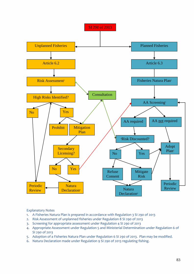
83
Explanatory Notes 1. A Fisheries Natura Plan is prepared in accordance with Regulation 3 SI 290 of 2013 2. Risk Assessment of unplanned fisheries under Regulation 8 SI 290 of 2013 3. Screening for appropriate assessment under Regulation 4 SI 290 of 2013 4. Appropriate Assessment under Regulation 5 and Ministerial Determination under Regulation 6 of
SI 290 of 2013 5. Adoption of a Fisheries Natura Plan under Regulation 6 SI 290 of 2013. Plan may be modified. 6. Natura Declaration made under Regulation 9 SI 290 of 2013 regulating fishing.
AA Screening3
AA Required?
Natura
Declaration6
High Risks Identified?
Yes
AA not required
Yes No
Adopt
Plan5 Secondary
Licensing?
AA required
No
Natura
Declaration6
Refuse
Consent
Periodic
Review Periodic
Review
Mitigate
Risk
Article 6.3 Article 6.2
Risk Assessment2
Prohibit Mitigation
Plan
Unplanned Fisheries Planned Fisheries
SI 290 of 2013
Fisheries Natura Plan1
4Risk Discounted?
Yes No
Consultation
84
Profiling of industry activity
For planned fisheries (art. 6.3), profiling of fishing activity is twofold. Operators quantify and map their proposed activity in their Fisheries Natura Plan. This is the plan submitted for appropriate assessment. Additional profiling is done using logbook data, VMS data, Marine Institute survey data and expert opinion resulting in maps showing the distribution of shellfish resources. For unplanned fisheries (art 6.2), profiling is done using logbook data, VMS data, expert opinion, Marine Institute survey data to show the distribution of shellfish resources, supplemented by questionnaire surveying of selected fishermen. Fishery profiling was completed for all SACs and SPAs in 2013.
Article 6 Assessments
As the roadmap indicated, and as agreed with the Commission, planned fisheries were to be assessed under Article 6.3 (appropriate assessment). Following communications and discussions with the Commission in 2012 and 2013, and in order to fulfil the obligations arising under article 6.2 in relation to all activities, planned or unplanned, a Risk Assessment Framework and Work Programme were put in place in 2013. The Risk Assessment programme seeks to establish scientifically, and in accordance with Commission guidance, the degree of risk, if any, posed by each type of fishing activity on the designated habitats and species in each site. Where significant risk is identified, mitigation measures are implemented. The Department is continuing to give priority to bringing the management of inshore fisheries into full compliance with the Habitats and Birds Directives and with the judgment of the European Court of Justice in case C418/04.
Appropriate Assessments Article 6.3 appropriate assessments are required prior to fisheries in Natura 2000 areas that are licensed (via fishing authorisations). Such assessments require detailed information on the operation of the particular activity to be licensed in order to carry out the assessment. However, many sea-fishing activities are not subject to specific fishing authorisation requirements, and detailed data is unavailable for appropriate assessments. Appropriate Assessments have been carried out for Castlemaine Harbour (mussel seed), Dundalk Bay (cockles) and the Irish Sea (mussel seed fishery, taking in 44 Natura sites). The Dundalk cockle fishery operates under the terms of the Fisheries Natura Plan 2016 – 2020 and is subject to regulatory measures put in place under Fisheries Natura Declaration No. 1 of 2016. Annual reviews of the environmental performance of the fishery are prepared and reviewed as part of the permitting decision process. The fishery did not open in 2014 based on a decision of the Dundalk cockle fishermen as the stock level was not significantly above the limit reference point. The fishery remained closed in 2015 due to low stock biomass but reopened in 2016 for vessels with permits issued to operators which held track record in the fishery. Hand gathering permits were not issued for 2016 due to concerns raised by the SFPA about the compliance of hand gatherers with permit conditions during the operation of the previous Fisheries Natura Plan. The permitting of a cockle hand-gathering fishery may be considered in the future. However, in order to revisit the current position, it would be important that those interested in participating in a cockle hand-gathering fishery develop a considered proposal to allay the compliance concerns. In line with the conclusion of the appropriate assessment, the mussel seed fishery in the Irish Sea (participation in the mussel fishery requires authorisation) operated under a Fisheries Natura Declaration which manages the fishery in accordance with the outcome of the assessment. The management measures involve continued closure of a significant part of the Wicklow Reef SAC as the risks to the qualifying features posed by the fishery could not be mitigated. Sites which have not yet been assessed remain closed to fishing for seed mussel on a precautionary basis.
85
After remaining closed in 2013 due to lack of suitable seed the mussel seed fishery in Castlemaine Harbour opened again for the 2014 and 2015 fisheries. This followed a survey assessment of the available seed biomass. The Appropriate Assessment process for a new FNP for the mussel seed fishery in Castlemaine Harbour is largely completed. Once an outstanding issue regarding invasive alien species has been resolved it is expected that the process will reach a swift conclusion. Risk Assessments In the December 2013 programme of measures, Ireland aimed to complete risk assessments for all sites (approx 158) by the first quarter of 2014. A risk assessment for ‘unplanned’ fisheries in the Irish Sea, from Carnsore to Carlingford, which takes in 44 Natura sites, underwent public consultation in 2013. Mitigation proposals for sites off the Wexford coast underwent consultation during mid 2014 and implementation commenced December 2014. Documents can be viewed here: http://www.fishingnet.ie/sea-fisheriesinnaturaareas/natura2000sitesundermanagement/wexford-rosslareandcahore/. The assessment of Roaringwater Bay was revised from an Article 6.3 to a 6.2 assessment during 2013. The proposed mitigation responses arising from the risk assessment of fishing activities in Roaringwater Bay underwent public consultation in Q4 2013. Following subsequent modifications to the mitigation responses, direct consultation was held with representatives of the local fishing industry during 2014. A Fisheries Natura Declaration is now in place to give legal effect to regulatory measures. Details of the mitigation plan and the Declaration can be viewed here: http://www.fishingnet.ie/sea-fisheriesinnaturaareas/natura2000sitesundermanagement/roaringwaterbay/ . The assessments for all other SACs (habitats and species taking in the remaining coastline from Wexford to Donegal) were completed in 2014 using the available conservation objectives and have been the subject of workshops with the relevant State bodies to ensure that all available data is correctly taken into account. These assessments have now been updated in line with the progress made on publishing Specific Conservation Objectives for all marine SACs. An assessment for all other SPAs (birds) is being undertaken separately by contractors on behalf of the MI. Reports on individual fisheries interactions with SPA qualifying interests have been drafted. Due to the volume of sites and the range of fisheries involved in this assessment, it is considered necessary to prioritise the development of mitigation measures in relation to the level of estimated risk. A prioritisation exercise and report was completed and discussed at stakeholder consultation meetings during 2015 along with the updated SAC assessment report. Mitigation of high risk scenarios have been implemented or are being developed with a particular focus on adopting a systematic approach. An important issue is that fisheries data is generally not available at a sufficiently fine resolution relative to the scale and size of habitat features. In order to improve the provision of data on the interaction between fisheries and features the Marine Institute is trialling the use of GPS monitoring technology on sea-fishing boats. Regulations were introduced in June 2015 to oblige all boats exploiting razor clams to carry fully-functioning GPS monitoring systems on board and to submit catch records so that (inter alia) the footprint of these fisheries can be monitored and managed with regard to its potential impact on the features of Natura 2000 sites. http://www.irishstatutebook.ie/eli/2015/si/206/made/en/print Fishing for scallop in Blacksod Bay was regulated in Q3 of 2015. A stock assessment of scallops was completed. The fishery is now closed. The use of mobile fishing gears on sensitive reef habitat in Blacksod Bay has been prohibited (Fisheries Natura declaration 3 of 2015 (http://www.fishingnet.ie/sea-fisheriesinnaturaareas/natura2000sitesundermanagement/blacksodbay/)
86
The Marine Institute’s 2013 Article 6.3 assessment for the Irish Sea identified potential impacts the Wexford razor clam fishery could have on nearby Natura sites. A mitigation response plan was developed for the fishery, taking into account the assessed risks. It proposed new and revised management measures to mitigate the fishery’s potential impacts on nearby Natura sites. It was published in Q2 2014 as part of a public consultation. On the basis of submissions received, and advice from the various marine agencies, the Minister in December 2014 approved a package of measures for this fishery. Key mitigation measures introduced for the fishery include reporting obligations (including GPS tracking of vessels) to monitor activity adjacent to Natura 2000 sites and spatial limits on the distribution of the fishery. A risk assessment of the Wexford Scallop fishery is completed. As part of the process public consultation on the risk assessment has been carried out and the responses have been assessed. It is expected that a new declaration will be implemented in Q2 2017.
Completed Appropriate Assessments5
River Barrow and River Nore (Waterford Estuary) (1 site) (planned surf clam dredge fishery) – AA screening out http://www.fishingnet.ie/sea-fisheriesinnaturaareas/concludedassessments/barrownorewaterfordestuary-clamfishery-sac/#d.en.72196
Dundalk Bay (2 sites) ( 2011) (planned cockle and mussel seed dredge fisheries) http://www.fishingnet.ie/sea-fisheriesinnaturaareas/concludedassessments/dundalkbay-sacspa/#d.en.72078
Castlemaine Harbour (2 sites) ( 2011) (planned mussel seed dredge fishery) http://www.fishingnet.ie/sea-fisheriesinnaturaareas/concludedassessments/castlemaineharbour-sacspa/#d.en.72077
Lough Swilly (2 sites) (2013) (planned oyster dredge fishery) http://www.agriculture.gov.ie/fisheries/aquacultureforeshoremanagement/aquaculturelicensing/appropriateassessmentscarriedout/loughswillyappropriateassessment/
Irish Sea (6 sites) (Aug 2013) (planned mussel seed dredge fishery) http://www.fishingnet.ie/sea-fisheriesinnaturaareas/concludedassessments/irishsea-includingmusselseedfishery/#d.en.72197
Completed Risk Assessments
Roaringwater Bay (SAC) (2013) (all unplanned fisheries) http://www.fishingnet.ie/sea-fisheriesinnaturaareas/natura2000sitesundermanagement/roaringwaterbay/
Donegal Bay (SAC & 2 SPA’s) http://www.fishingnet.ie/sea-fisheriesinnaturaareas/concludedassessments/donegalbay-sac2spas/#d.en.72195
Irish Sea (24 SACs and 20 SPAs)(all unplanned fisheries) http://www.fishingnet.ie/sea-fisheriesinnaturaareas/concludedassessments/irishsea-includingmusselseedfishery/#d.en.72197
5 Appropriate assessment includes screening for appropriate assessment
87
South & West Coasts (37 SACs)(all unplanned fisheries) (Marine Institute 2015. Article 6.2 (Habitats Directive) risk assessment. The effects of fisheries on qualifying interests in Special Areas of Conservation in Irish coastal waters. Marine Institute, 356pp.)
Wexford Scallop (2 SACs) http://www.fishingnet.ie/sea-fisheriesinnaturaareas/currentconsultation/scallopwexford/
Managing the risk of escalation of new activities
Article 6.2 of the Habitats Directive aims to avoid deterioration of habitats and species that could result from human activities and the risk assessment process is integral to identifying the likelihood of these effects occurring. Potential new fisheries, especially dredge fisheries for bivalves, that might develop under existing fisheries arrangements have been included in the risk assessment report. Harvesting of live bivalve shellfish can only take place in production areas which have been classified by the competent authority (the SFPA in Ireland’s case) in accordance with Regulation EC 854/2004. To prevent unmanaged escalation of new bivalve fisheries, new protocols for their management have been drafted and discussed with the Regional Inshore Fisheries Forums. This protocol defines the conditions under which new fisheries could develop so that they are sustainably managed and do not cause deterioration of habitats or species. These conditions are developed as part of the decision (by Ireland’s Sea Fisheries Protection Authority) to classify production areas and further assessed (stock assessment, detailed mapping of the proposed fishing area) by MI once a decision has been made to classify. During the minimum 6 month period needed to classify such areas the authorities develop management measures with the industry in response to risks (including risk of overexploitation of the target species) identified in the MI assessments. By way of example of this new approach, a limited fishing period for razor clams was facilitated at Inishkea Islands in early 2016 following a stock survey and taking account of the risk assessment outcome of dredge activities on the Natura 2000 site. On reaching the recommended outtake, a statutory instrument was introduced to curtail further fishing. This instrument was revoked in the latter part of the year after a local management arrangement was agreed with fishermen and their representatives.
Consultation and publication of information
Stakeholder involvement in considering assessments and designing mitigation has been reviewed to ensure consistency with both the Common Fisheries Policy and the Aarhus Convention. In May 2014, the Minister announced the establishment of a National Inshore Fisheries Forum (NIFF) to provide inshore fishing communities with their own space for convening and bringing common initiatives forward. A network of Regional Inshore Fisheries Forums (RIFFs), based on and linked to the six community-led Fisheries Local Action Groups (FLAGs) around the Irish coast, have nominated delegates to the NIFF to bring forward regional proposals to that body for wider industry discussion. The purpose of the Forums will primarily be to develop and facilitate implementation of policies and initiatives relating to the sustainable management of the inshore fisheries within six nautical miles; this will include consideration of relevant fisheries management measures for Natura 2000 sites. While the Forums are primarily aimed at developing a stakeholder group for inshore fishermen, up to one third of the membership of the Regional Inshore Forums also comprise other marine stakeholders including environmental interest groups. The Forums are not intended to replace statutory and wider public consultation. Each of the 6 Regional Inshore Fisheries Forums has been briefed on Natura 2000. Presentations including case studies and progress updates have also been given at the National Inshore Fisheries Forum meetings (January and April 2015). A programme of risk mitigation planning is now underway and as a first step the Regional Forums
88
received information on interactions relevant to their areas during Q2-Q3 2015 so that risk mitigation strategies can be developed with appropriate stakeholders. The Forums have also been engaged on the measures being prepared to prevent escalation in unmanaged bivalve sea-fisheries. S.I. 290 of 2013 provides in Regulation 5 for a mandatory process of inter-service and public consultation on the fisheries elements of an appropriate assessment and on the related Fisheries Natura Plan (FNP) which was the subject of that appropriate assessment. Note that the FNPs are drafted in the first instance by fishing interests and so are privately drafted plans. Regulation 8 similarly provides for consultation on article 6.2 Risk Assessment reports. Stakeholders are required to be given one month to make submissions in both cases. A response is provided to each submission addressing all relevant issues raised in the submission. These are published on the Department’s fishingnet.ie website. In accordance with the requirements of S.I. 477 of 2011, the Minister’s determination on a planned fishery and related appropriate assessment is published on the Department’s website, setting out the reasons for the Minister’s decision on the plan. The Department’s website for fisheries in Natura 2000 sites was re-designed in 2013 to present all information relevant to the Department’s functions in this area, including all legislation, guidance, plans, assessment reports, Determinations, Natura Declarations, template permits and periodic review reports. See http://www.fishingnet.ie/sea-fisheriesinnaturaareas/ The newly established Regional Inshore Fisheries Forums and National Inshore Fisheries Forum provide an additional platform for direct stakeholder consultation on risk assessment, appropriate assessment and mitigation planning.
Licensing following appropriate assessment
S.I. 290 of 2013 provides for the making of legal instruments called Natura Declarations following appropriate assessment/risk assessment. A comprehensive range of regulatory interventions can be implemented through Natura Declarations, including prohibitions on fishing activity and restriction of fishing by permitting regimes. Appropriate assessments were completed in 2017 for Castlemaine Harbour SAC/SPA, in 2016 of Dundalk Bay SAC/SPA and in 2013 of 6 Irish Sea sites. Natura Declarations were issued for each fishery enforcing conditions of fishing. In respect of Castlemaine Harbour SAC/SPA, the Natura Declaration restricts mussel seed fishing in the harbour to permit holders. Permits in turn restrict fishing to defined coordinates and imposed catch limits in order to preserve a percentage of the mussel biomass for over-wintering birds. Likewise, the 2016 Natura Declaration for Dundalk Bay imposed a minimum landing size for cockles, restricted cockle fishing to permit holders, for both dredge fishing and hand raking from the shore and specified mechanisms for triggering closure of the fishery to preserve a percentage of cockles for over-wintering birds. Fishing for cockles did not take place during 2014 or 2015. Permits were only issued to vessels for cockle fishing in Dundalk Bay for 2016. As there was evidence of poor compliance amongst hand gatherers in recent years, no permits were issued for this activity.
89
The Natura Declaration in relation to fishing for mussel seed in the 6 Irish Sea sites assessed in 2013 prohibited mussel fishing in the sensitive reef habitat of Wicklow Reef SAC and imposed conditions on fishing for mussel seed within a buffer zone around the prohibited area. The Declaration also prohibited mussel fishing in 16 other Natura 2000 sites around the coast pending appropriate assessment. A further 3 Natura 2000 sites were added to the Declaration in 2014 on a precautionary basis.
Monitoring and control following licensing
For each Natura site within which a fishery was opened following appropriate assessment, a requirement was put in place for Periodic Reviews. These reviews consider if any circumstances have changed that may warrant an amendment to the related Fisheries Natura Plan or the appropriate assessment report. Management arrangements are reviewed to ensure that the Plan continues to have no adverse effects on the Natura sites concerned. Reviews were completed in 2012 and 2013 and were published online at http://www.fishingnet.ie, the Government's commercial sea-fishing network portal. In due course, reviews will be carried out and published under the new fisheries Natura plans for Dundalk Bay and Castlemaine Harbour. In addition, in relation to the fishery opened following appropriate assessment, a unique and comprehensive fishery control plan was drafted by Ireland’s Sea Fisheries Protection Authority. In Castlemaine Harbour, each vessel active in the fishery was required to operate an onboard vessel positioning system, which continuously reported the vessel’s position within the site and on the seed bed external to the site. Each vessel was required to make requisite returns using gatherers dockets and logbook records of quantities of seed taken onboard and re-laid. In Dundalk Bay for 2013 and 2016, the number of vessels fishing cockles was restricted by permit. Each vessel was required to make returns showing the time, location, the gross catch and the permit number. For 2013, hand gatherers active in this fishery were issued permits and required to complete gathers dockets for any cockle taken. Inspections by SFPA officers took place throughout the period of the fishery. Due to evidence of poor compliance amongst hand gatherers, no such permits were issued in 2016. No cockle fishing took place in Dundalk Bay in 2014 or 2015. In the Irish Sea mussel seed fishery, participating vessels were prohibited from the sensitive reef habitat of the Wicklow Reef SAC. A geo-fenced buffer zone was imposed around the closed area and vessels fishing for mussel seed in the buffer zone were required to report their position through a Vessel Monitoring System (VMS) every 5 minutes.
Post Assessment Monitoring Activities
Findings of non-significant effects during AA can be derived with different levels of confidence. Where the level of confidence in findings was not high and where the consequences of ‘getting it wrong’ could be significant targeted environmental monitoring programmes were put in place. The two AAs that were completed in Dundalk Bay and Castlemaine Harbour were followed by extensive effects monitoring programmes. Outputs include:
Assessment of the potential effects of cockle harvesting in Dundalk Bay, Co. Louth on shorebirds, the aim of which was to examine the effect of cockle fishing on waterbird utilisation of intertidal habitat in Dundalk Bay. Results of this study are available at http://www.fishingnet.ie/media/fishingnet/content/fisheriesinnaturaareas/siteassessments/dundalkbay/AA%20Annex%20IV%20waterbirds%20and%20cockles.pdf
Monitoring of Oystercatcher numbers, spatial distribution & diet in Dundalk Bay SPA, Co. Louth (2011 - 2013) the aim of which is to monitor numbers of Oystercatcher at Dundalk to quantify the composition of the diet of the Dundalk Bay Oystercatcher population and to use these data to inform the licensing of a cockle fishery in the bay. This work is ongoing.
90
BACI effects monitoring of hydraulic dredging for cockles on the intertidal benthic habitats of Dundalk Bay, Ireland in 2009 and 2010. This study looked for effects of hydraulic dredging for cockles on benthos using a control impact before after experimental design. The report is available from the Marine Institute.
Annual monitoring of bivalve distribution and abundance in Dundalk Bay 2010-2012. Annual surveys are conducted to detect any changes in distribution or abundance of characterising bivalves in the bay which supports a cockle fishery. Reports are available from the Marine Institute.
Impact of dredging on undersized discard cockle and bivalves; a study was completed in Dundalk Bay prior to the opening of the 2013 fishery.
Annual monitoring of mussel cover on intertidal marine habitats in Castlemaine Harbour using aerial imagery
Monitoring distribution of seabirds by aerial survey in coastal waters of the western Irish Sea in relation to inshore dredge fisheries for bivalves. Two surveys were completed by contractors to the Marine Institute in March and December 2014 .
Original research on the potential effects of using static fishing gears (pots) on seagrass, maerl and Laminaria reef was completed in 2015.
Work programme 2016 Work programme 2017
Risk assessment of fisheries in SPAs will be completed. The data compiled to date does not show any high priority risk to special conservation interests (SCIs) in SPAs from Inshore Fisheries activities other than in the case of intertidal fisheries for bivalves. Such effects are already managed in Dundalk Bay and Castlemaine Harbour. If other intertidal fisheries are proposed then risk will be managed under the protocol for new fisheries discussed above
Mitigation, including the use of closed areas, of the effects of scallop fishing in SACs
Appropriate assessment of revised Fisheries Natura Plan for Castlemaine Harbour completed in Q1 2017. Dundalk Bay implementation during 2017.
Original research will be undertaken to assess the following o Effects of hydraulic fishing for razor clams in sub-tidal sedimentary habitats in the
north west Irish Sea o Effects of winter dredge fisheries for oysters on the quality of summer seagrass
beds in SACs. o Supplementary research on effects of potting on seagrass
91
Annex 1 Appropriate Assessment and Risk Assessment of Sea-Fisheries
The following is a schedule of completed and planned Appropriate Assessments and Risk Assessments for Sea-Fisheries.
Fisheries - Article 6 Assessment Status
Sites Designation Appropriate Assessment6
Risk Assessment
Castlemaine Harbour SPA Complete -
Castlemaine Harbour SAC SAC Complete -
Dundalk Bay SAC Complete -
Dundalk Bay SPA Complete -
Roaringwater Bay and Islands SAC - Complete
Donegal Bay (Murvagh) SAC - Complete
Donegal Bay SPA - Complete
Donegal Bay (Durnesh Lough) SPA - Complete
Loughswilly SAC Complete -
Lough Swilly SPA Complete -
Baldoyle Bay SAC - Complete
Blackwater Bank SAC Complete Complete
Boyne Coast and Estuary SAC - Complete
Bray Head SAC - Complete
Buckroney-Brittas Dunes and Fen SAC - Complete
Cahore Polders and Dunes SAC - Complete
Carlingford Shore SAC - Complete
Carlingford Lough SPA - Complete
Clogher Head SAC - Complete Kilmuckridge-Tinnaberna Sandhills SAC
- Complete
Kilpatrick Sandhills SAC - Complete
Lambay Island SAC - Complete
Long Bank SAC Complete Complete
Magherabeg Dunes SAC - Complete
Malahide Estuary SAC - Complete
North Dublin Bay SAC - Complete
Raven Point Nature reserve SAC - Complete
Rockabill to Dalkey SAC Complete Complete
Rogerstown Estuary SAC - Complete
Slaney River Valley SAC SAC - Complete
South Dublin Bay SAC - Complete
The Murrough Wetlands SAC - Complete
Wicklow Reef SAC Complete Complete
Baldoyle Bay SPA - Complete
Boyne Estuary SPA - Complete
6 ‘appropriate assessment’ includes screening for appropriate assessment
92
Cahore Marshes SPA - Complete
Dalkey Island SPA - Complete
Howth Head Coast SPA - Complete
Irelands Eye SPA - Complete
Lambay Island SPA - Complete
Malahide Estuary SPA - Complete
North Bull Island SPA - Complete
River Nanny estuary and Shore SPA - Complete
Rockabill SPA Complete Complete
Rogerstown estuary SPA - Complete
Skerries Islands SPA - Complete South Dublin Bay and River Tolka Estuary SPA
- Complete
The Murrough SPA - Complete
The Raven SPA Complete
Wexford Harbour and Slobs SPA - Complete
Wicklow Head SPA Complete Complete
Carnsore Pt SAC Complete
Saltees Is SPA Complete
Hook Head SAC Complete
Achill Head SAC - Complete
Akeragh, Banna and Barrow Hbr SAC - Complete
Aran Island (Donegal) cliffs SAC - Complete
Ardmore Hd SAC - Complete
Ballinskelligs Bay and Inny Estuary SAC - Complete
Ballyhoorisky Point to Fanad Head SAC
- Complete
Ballymacoda (Clonpriest and Pillmore) SAC
- Complete
Ballyness Bay SAC - Complete
Ballysadare Bay SAC - Complete
Ballyteigue Burrow SAC - Complete
Bannow Bay SAC - Complete
Barley Cove to Ballyrisode Pt SAC - Complete
Black Hd Poulsallagh Complex SAC - Complete
Blackwater River (Cork/Waterford) SAC
- Complete
Blasket Islands SAC - Complete
Broadhaven Bay SAC - Complete
Bunduff Lough and Machair/Trawalua/Mullaghmore SAC
- Complete
Carrowmore Dunes SAC - Complete
Carrowmore Point to Spanish Point and Islands SAC
- Complete
Clew Bay complex SAC - Complete
Clonakilty Bay SAC - Complete
Courtmacsharry Estuary SAC - Complete
Cummeen Strand/Drumcliff Bay (Sligo Bay) SAC
- Complete
Durnesh Lough SAC - Complete
93
Duvillaun Islands SAC - Complete
Galway Bay complex SAC - Complete
Glengariff Hbr and Woodland SAC - Complete
Great Island Channel SAC - Complete
Gweedore Bay and Islands SAC - Complete
Helvick Head SAC - Complete
Hempton's Turbot Bank SAC - Complete
Horn Head and Rinclevan SAC - Complete
Inagh River estuary SAC - Complete
Inisboffin and Inishark SAC - Complete
Inismaan Island SAC - Complete
Inismore Island SAC - Complete
Inisoir Island SAC - Complete
Inistrahull SAC - Complete
Kenmare River SAC - Complete
Kerry Hd shoal SAC - Complete
Kilkee reefs SAC - Complete
Kilkieran Bay and Islands SAC - Complete
Killala Bay/Moy Estuary SAC - Complete
Kingstown Bay SAC - Complete
Lackan Saltmarsh and Kilcummin Hd SAC
- Complete
Lough Hyne Nature reserve and Environs SAC
- Complete
Lower River Shannon SAC - Complete
Magharee Is SAC - Complete
Mullet/Blacksod Bay complex SAC - Complete
Mulroy Bay SAC - Complete
North Inishowen Coast SAC - Complete
Omey Island machair SAC - Complete
Rathlin O'Beirne Island SAC - Complete
River Barrow and River Nore SAC Complete Complete
Rutland Island and Sound SAC - Complete
Saltee Islands SAC - Complete
Sheephaven SAC - Complete
Slieve Tooey/Tormore Island/Loughros Beg Bay SAC
- Complete
Slyne Hd Islands SAC - Complete
Slyne Hd penninsula SAC - Complete
St. Johns Point SAC - Complete
Streedagh Point Dunes SAC - Complete
Tacumshin Lake SAC - Complete
Tory Island coast SAC - Complete
Tralee Bay and Magharees Peninsula SAC
- Complete
Tramore Dunes and Backstrand SAC - Complete
Valentia Hbr/Portmagee Channel SAC - Complete
West Connacht Coast_north SAC - Complete
West Connacht Coast_south SAC - Complete
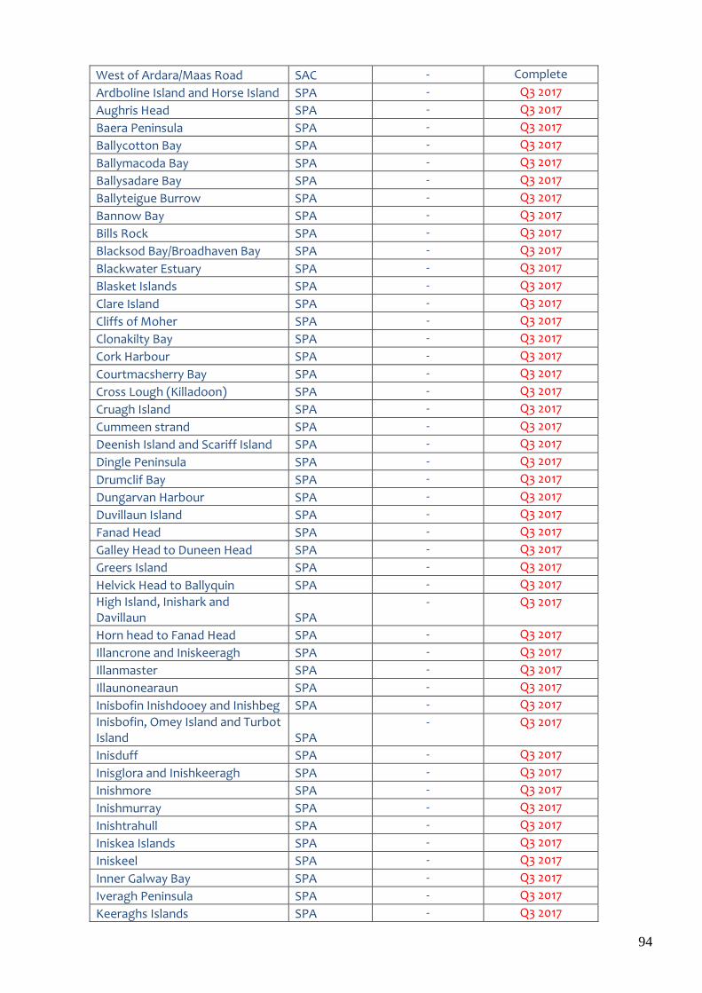
94
West of Ardara/Maas Road SAC - Complete
Ardboline Island and Horse Island SPA - Q3 2017
Aughris Head SPA - Q3 2017
Baera Peninsula SPA - Q3 2017
Ballycotton Bay SPA - Q3 2017
Ballymacoda Bay SPA - Q3 2017
Ballysadare Bay SPA - Q3 2017
Ballyteigue Burrow SPA - Q3 2017
Bannow Bay SPA - Q3 2017
Bills Rock SPA - Q3 2017
Blacksod Bay/Broadhaven Bay SPA - Q3 2017
Blackwater Estuary SPA - Q3 2017
Blasket Islands SPA - Q3 2017
Clare Island SPA - Q3 2017
Cliffs of Moher SPA - Q3 2017
Clonakilty Bay SPA - Q3 2017
Cork Harbour SPA - Q3 2017
Courtmacsherry Bay SPA - Q3 2017
Cross Lough (Killadoon) SPA - Q3 2017
Cruagh Island SPA - Q3 2017
Cummeen strand SPA - Q3 2017
Deenish Island and Scariff Island SPA - Q3 2017
Dingle Peninsula SPA - Q3 2017
Drumclif Bay SPA - Q3 2017
Dungarvan Harbour SPA - Q3 2017
Duvillaun Island SPA - Q3 2017
Fanad Head SPA - Q3 2017
Galley Head to Duneen Head SPA - Q3 2017
Greers Island SPA - Q3 2017
Helvick Head to Ballyquin SPA - Q3 2017
High Island, Inishark and Davillaun SPA
- Q3 2017
Horn head to Fanad Head SPA - Q3 2017
Illancrone and Iniskeeragh SPA - Q3 2017
Illanmaster SPA - Q3 2017
Illaunonearaun SPA - Q3 2017
Inisbofin Inishdooey and Inishbeg SPA - Q3 2017
Inisbofin, Omey Island and Turbot Island SPA
- Q3 2017
Inisduff SPA - Q3 2017
Inisglora and Inishkeeragh SPA - Q3 2017
Inishmore SPA - Q3 2017
Inishmurray SPA - Q3 2017
Inishtrahull SPA - Q3 2017
Iniskea Islands SPA - Q3 2017
Iniskeel SPA - Q3 2017
Inner Galway Bay SPA - Q3 2017
Iveragh Peninsula SPA - Q3 2017
Keeraghs Islands SPA - Q3 2017
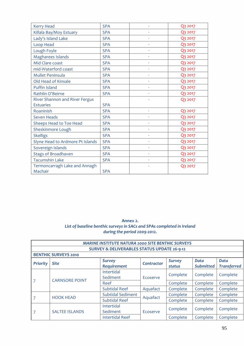
95
Kerry Head SPA - Q3 2017
Killala Bay/Moy Estuary SPA - Q3 2017
Lady's Island Lake SPA - Q3 2017
Loop Head SPA - Q3 2017
Lough Foyle SPA - Q3 2017
Magharees Islands SPA - Q3 2017
Mid Clare coast SPA - Q3 2017
mid-Waterford coast SPA - Q3 2017
Mullet Peninsula SPA - Q3 2017
Old Head of Kinsale SPA - Q3 2017
Puffin Island SPA - Q3 2017
Rathlin O'Beirne SPA - Q3 2017
River Shannon and River Fergus Estuaries SPA
- Q3 2017
Roaninish SPA - Q3 2017
Seven Heads SPA - Q3 2017
Sheeps Head to Toe Head SPA - Q3 2017
Sheskinmore Lough SPA - Q3 2017
Skelligs SPA - Q3 2017
Slyne Head to Ardmore Pt Islands SPA - Q3 2017
Sovereign Islands SPA - Q3 2017
Stags of Broadhaven SPA - Q3 2017
Tacumshin Lake SPA - Q3 2017
Termoncarragh Lake and Annagh Machair SPA
- Q3 2017
Annex 2. List of baseline benthic surveys in SACs and SPAs completed in Ireland
during the period 2009-2012.
MARINE INSTITUTE NATURA 2000 SITE BENTHIC SURVEYS
SURVEY & DELIVERABLES STATUS UPDATE 26-9-12
BENTHIC SURVEYS 2010
Priority Site Survey Requirement
Contractor Survey status
Data Submitted
Data Transferred
7 CARNSORE POINT
Intertidal Sediment Ecoserve
Complete Complete Complete
Reef Complete Complete Complete
Subtidal Reef Aquafact Complete Complete Complete
7 HOOK HEAD Subtidal Sediment
Aquafact Complete Complete Complete
Subtidal Reef Complete Complete Complete
7 SALTEE ISLANDS Intertidal Sediment Ecoserve
Complete Complete Complete
Intertidal Reef Complete Complete Complete
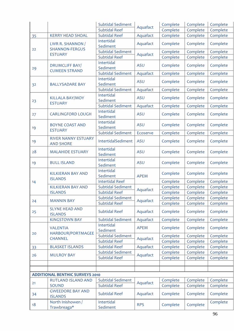
96
Subtidal Sediment Aquafact
Complete Complete Complete
Subtidal Reef Complete Complete Complete
35 KERRY HEAD SHOAL Subtidal Reef Aquafact Complete Complete Complete
22 LWR R. SHANNON / SHANNON-FERGUS ESTUARY
Intertidal Sediment
Aquafact Complete Complete Complete
Subtidal Sediment Aquafact
Complete Complete Complete
Subtidal Reef Complete Complete Complete
29 DRUMCLIFF BAY/ CUMEEN STRAND
Intertidal Sediment
ASU Complete Complete Complete
Subtidal Sediment Aquafact Complete Complete Complete
32 BALLYSADARE BAY Intertidal Sediment
ASU Complete Complete Complete
Subtidal Sediment Aquafact Complete Complete Complete
23 KILLALA BAY/MOY ESTUARY
Intertidal Sediment
ASU Complete Complete Complete
Subtidal Sediment Aquafact Complete Complete Complete
27 CARLINGFORD LOUGH Intertidal Sediment
ASU Complete Complete Complete
19 BOYNE COAST AND ESTUARY
Intertidal Sediment
ASU Complete Complete Complete
Subtidal Sediment Ecoserve Complete Complete Complete
19 RIVER NANNY ESTUARY AND SHORE
IntertidalSediment ASU Complete Complete Complete
28 MALAHIDE ESTUARY Intertidal Sediment
ASU Complete Complete Complete
19 BULL ISLAND Intertidal Sediment
ASU Complete Complete Complete
14
KILKIERAN BAY AND ISLANDS
Intertidal Sediment APEM
Complete Complete Complete
Intertidal Reef Complete Complete Complete
KILKIERAN BAY AND ISLANDS
Subtidal Sediment Aquafact
Complete Complete Complete
Subtidal Reef Complete Complete Complete
24 MANNIN BAY Subtidal Sediment
Aquafact Complete Complete Complete
Subtidal Reef Complete Complete Complete
25 SLYNE HEAD AND ISLANDS
Subtidal Reef Aquafact Complete Complete Complete
KINGSTOWN BAY Subtidal Sediment Aquafact Complete Complete Complete
20 VALENTIA HARBOUR/PORTMAGEE CHANNEL
Intertidal Sediment
APEM Complete Complete Complete
Subtidal Sediment Aquafact
Complete Complete Complete
Subtidal Reef Complete Complete Complete
33 BLASKET ISLANDS Subtidal Reef Aquafact Complete Complete Complete
26 MULROY BAY Subtidal Sediment
Aquafact Complete Complete Complete
Subtidal Reef Complete Complete Complete
ADDITIONAL BENTHIC SURVEYS 2010
21 RUTLAND ISLAND AND SOUND
Subtidal Sediment Aquafact
Complete Complete Complete
Subtidal Reef Complete Complete Complete
34 GWEEDORE BAY AND ISLANDS
Subtidal Reef Aquafact Complete Complete Complete
18 North Inishowen / Trawbreaga*
Intertidal Sediment
RPS Complete Complete Complete
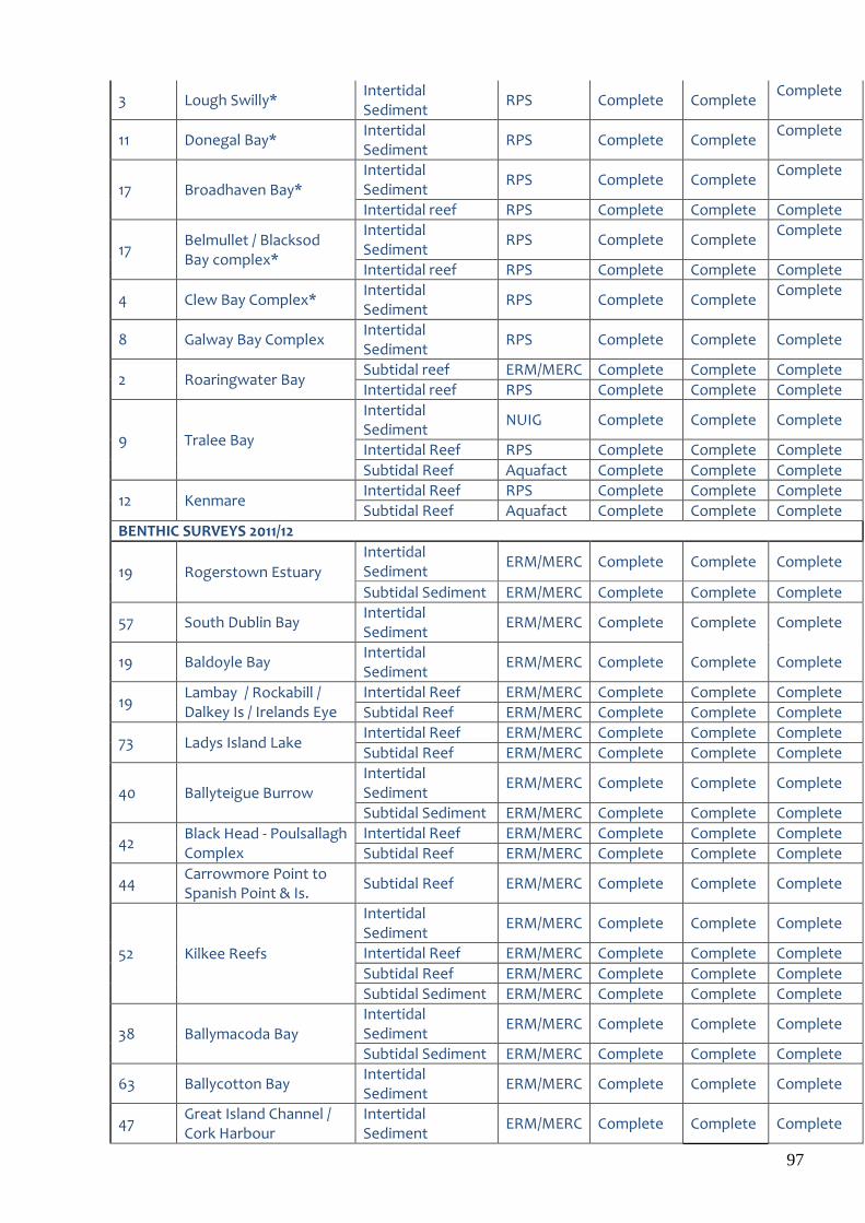
97
3 Lough Swilly* Intertidal Sediment
RPS Complete Complete Complete
11 Donegal Bay* Intertidal Sediment
RPS Complete Complete Complete
17 Broadhaven Bay* Intertidal Sediment
RPS Complete Complete Complete
Intertidal reef RPS Complete Complete Complete
17 Belmullet / Blacksod Bay complex*
Intertidal Sediment
RPS Complete Complete Complete
Intertidal reef RPS Complete Complete Complete
4 Clew Bay Complex* Intertidal Sediment
RPS Complete Complete Complete
8 Galway Bay Complex Intertidal Sediment
RPS Complete Complete Complete
2 Roaringwater Bay Subtidal reef ERM/MERC Complete Complete Complete
Intertidal reef RPS Complete Complete Complete
9 Tralee Bay
Intertidal Sediment
NUIG Complete Complete Complete
Intertidal Reef RPS Complete Complete Complete
Subtidal Reef Aquafact Complete Complete Complete
12 Kenmare Intertidal Reef RPS Complete Complete Complete
Subtidal Reef Aquafact Complete Complete Complete
BENTHIC SURVEYS 2011/12
19 Rogerstown Estuary
Intertidal Sediment
ERM/MERC Complete Complete Complete
Subtidal Sediment ERM/MERC Complete Complete Complete
57 South Dublin Bay Intertidal Sediment
ERM/MERC Complete Complete Complete
19 Baldoyle Bay Intertidal Sediment
ERM/MERC Complete Complete Complete
19 Lambay / Rockabill / Dalkey Is / Irelands Eye
Intertidal Reef ERM/MERC Complete Complete Complete
Subtidal Reef ERM/MERC Complete Complete Complete
73 Ladys Island Lake Intertidal Reef ERM/MERC Complete Complete Complete
Subtidal Reef ERM/MERC Complete Complete Complete
40 Ballyteigue Burrow Intertidal Sediment
ERM/MERC Complete Complete Complete
Subtidal Sediment ERM/MERC Complete Complete Complete
42 Black Head - Poulsallagh Complex
Intertidal Reef ERM/MERC Complete Complete Complete
Subtidal Reef ERM/MERC Complete Complete Complete
44 Carrowmore Point to Spanish Point & Is.
Subtidal Reef ERM/MERC Complete Complete Complete
52 Kilkee Reefs
Intertidal Sediment
ERM/MERC Complete Complete Complete
Intertidal Reef ERM/MERC Complete Complete Complete
Subtidal Reef ERM/MERC Complete Complete Complete
Subtidal Sediment ERM/MERC Complete Complete Complete
38 Ballymacoda Bay Intertidal Sediment
ERM/MERC Complete Complete Complete
Subtidal Sediment ERM/MERC Complete Complete Complete
63 Ballycotton Bay Intertidal Sediment
ERM/MERC Complete Complete Complete
47 Great Island Channel / Cork Harbour
Intertidal Sediment
ERM/MERC Complete Complete Complete

98
46 Courtmacsherry Bay & Estuary
Intertidal Sediment
ERM/MERC Complete Complete Complete
Subtidal Sediment ERM/MERC Complete Complete Complete
45 Clonakilty Bay Intertidal Sediment
ERM/MERC Complete Complete Complete
Barleycove to Ballyrisode Point
Intertidal Sediment
ERM/MERC Complete Complete Complete
BENTHIC SURVEYS 2011/12
39 Ballyness Bay Intertidal Sediment
ERM/MERC Complete Complete Complete
Subtidal Sediment ERM/MERC Complete Complete Complete
54 Rathlin O'Beirne Island Subtidal Reef ERM/MERC Complete Complete Complete
56 Slieve League Subtidal Reef ERM/MERC Complete Complete Complete
58 St Johns Point
Subtidal Sediment ERM/MERC Complete Complete Complete
Subtidal Reef ERM/MERC Complete Complete Complete
Intertidal Sediment
ERM/MERC Complete Complete Complete
60 Tory Island Coast Subtidal Reef ERM/MERC Complete Complete Complete
62 West of Ardara / Mass Road
Intertidal Sediment
ERM/MERC Complete Complete Complete
Subtidal Sediment ERM/MERC Complete Complete Complete
55 Sheephaven
Intertidal Sediment
ERM/MERC Complete Complete Complete
61 Tranarosan and Melmore Lough
Intertidal Sediment
ERM/MERC Complete Complete Complete
64 Lough Foyle
Intertidal Sediment
ERM/MERC Complete Complete Complete
65 Mid Clare Coast
Intertidal Sediment
ERM/MERC Complete Complete Complete
Intertidal Reef ERM/MERC Complete Complete Complete
37
Achill Head
Intertidal Sediment
ERM/MERC Complete Complete Complete
Subtidal Sediment ERM/MERC Complete Complete Complete
Subtidal Reef ERM/MERC Complete Complete Complete
49 Inisheer Island Subtidal Reef ERM/MERC Complete Complete Complete
50 Inishmann Island Subtidal Reef ERM/MERC Complete Complete Complete
51 Inishmore Island Subtidal Reef ERM/MERC Complete Complete Complete
25
Slyne Head Peninsula
Intertidal Sediment
ERM/MERC Complete Complete Complete
Intertidal Reef ERM/MERC Complete Complete Complete
Subtidal Sediment ERM/MERC Complete Complete Complete
Subtidal Reef ERM/MERC Complete Complete Complete
72 Conemara Bog Complex (Salt Lake)
Subtidal Reef ERM/MERC Complete Complete Complete
43
Bunduff Lough & Machair / Trawalua
Subtidal Reef ERM/MERC Complete Complete Complete
Subtidal Sediment ERM/MERC Complete Complete Complete
Intertidal Sediment
ERM/MERC Complete Complete Complete
Intertidal Reef ERM/MERC Complete Complete Complete
59 Streedagh Point Dunes
Intertidal Sediment ERM/MERC Complete Complete Complete
Kish/Bray Bank Subtidal sediment Aquafact Complete Complete Complete

99
Blackwater Bank Subtidal sediment Aquafact Complete Complete Complete
Hemptons Bank Subtidal sediment ERM/MERC Complete Complete Complete
49-51 Aran Islands Sea caves ERM/MERC Complete Complete Complete
2 Roaringwater Bay Sea caves ERM/MERC Complete Complete Complete
53 Lough Hyne & Reef Sea caves / reef ERM/MERC Complete Complete Complete
BENTHIC SURVEYS 2012/2013
Wicklow reef Reef ERM/MERC Complete Complete Complete