texas conservation easements - c.ymcdn.com of conservation easements may meet more than one...
TRANSCRIPT

Texas
Conservation Easements

Agenda
• What is a conservation easement?
• Resources for conservation
easements and land trusts
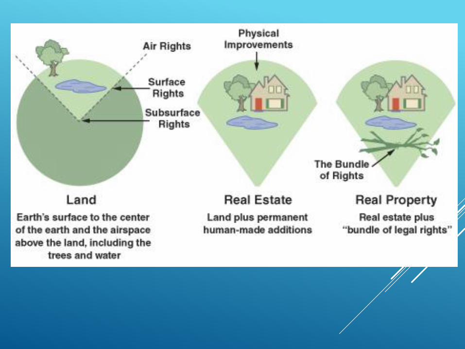
• Real Property – Bundle of
Rights
• Conditions
• Landowner Benefits
• Tax deductions
• Funding Options
• Required Information
• Surveyor Involvement
• Digital data sharing

What is a land trust?
Their mission is to preserve land
via conservation easements
and/or acquisition.

What is a land trust?
There are 30 land trusts in Texas that hold
conservation easements and 1,100 land
trusts in the U.S.

Land Trust Membership Criteria
Non profits public charity IRS
Land Protection and Stewardship
focus
Up to date on annual dues
Individual Membership
Professional Membership
Inclusion in the resource guide for
landowner and land trusts
Find a land trust for your county


Understanding Real Property Rights


What is an Easement?
• Easement: ROW, pipeline, utility, ingress egress, conservation…
• An easement is commonly defined as a nonpossessory interest in
another person's land. The nonpossessory nature of an easement is
one of its primary -- and potentially confusing -- characteristics. An
easement is a property interest that allows the holder of the easement
to use property that he or she does not own or possess. An easement
does not allow the easement holder to occupy the land, or to exclude
others from the land.
- realestate.findlaw.com

NATURAL RESOURCES CODE
TITLE 8. ACQUISITION OF RESOURCES
CHAPTER 183. CONSERVATION EASEMENTS
SUBCHAPTER A. CONSERVATION EASEMENTS GENERALLY
Sec. 183.001. DEFINITIONS. In this chapter:
(1) "Conservation easement" means a nonpossessory interest of a
holder in real property that imposes limitations or affirmative
obligations designed to:
(A) retain or protect natural, scenic, or open-space values of
real property or assure its availability for agricultural, forest,
recreational, or open-space use;
(B) protect natural resources;
(C) maintain or enhance air or water quality; or
(D) preserve the historical, architectural, archeological, or
cultural aspects of real property.
- http://www.statutes.legis.state.tx.us/Docs/NR/htm/NR.183.htm

What is a Conservation Easement?
• Voluntary legal agreement between a landowner and conservation
organization that places restrictions on specified future land uses.
• RIGHTS
• Land ownership carries with it a bundle of rights—the right to occupy,
lease, sell, develop, construct buildings, farm, restrict access or harvest
timber, among others.
• A landowner can give up one or more of those rights for a purpose such
as conservation while retaining ownership of the remainder of the rights.
• In ceding a right, the landowner "eases" it to another entity, such as a
land trust. For example, a landowner may give up the right to build
additional structures while retaining the right to grow crops.
• Land Trust holds the defined RIGHTS, often termed DEVELOPMENT
RIGHTS

What is a Conservation Easement?
• To qualify as a federal charitable income tax deduction under IRC
section 170(h):
• Donated to a qualified organization and granted in perpetuity
Perpetuity
A deductible conservation easement must be made in perpetuity,
permanently restricting the use of the property. IRC § 170(h)(2)(C) and
(5)(A) and Treas. Reg. § 1.170A-14(b)(2).
This means that the deed of conservation easement must state that:
The restriction remains on the property forever and,
Is binding on current and future owners of the property.

What is a Conservation Easement?
• To qualify as a federal charitable income tax deduction under IRC
section 170(h):
The easement must be created by deed and be exclusively for
conservation purposes. Donations of conservation easements may
meet more than one conservation purpose.
• Achieves at least one of the following conservation purposes:
• Preserves land for public recreation or education
• Protects natural habitat
• Preserves open space for scenic enjoyment, or for public policy
(open space plan)
• Preserves historically important land

Benefits to Landowners
Landowners receive Federal Income Tax deductions, Estate Tax relief, and
Property Tax relief, while retaining ownership of their land.
Example:
Land is worth $500,000 for potential residential development but only $200,000 as
open space or recreational use.
A conservation easement reduces the value of the land by $300,000.
LAND WHOLE – DEVELOPMENT RIGHTS = REDUCED VALUE of LAND
(unencumbered) - (tax deduction value) = (land value with CE)
$500,000 - $300,000 = $200,000
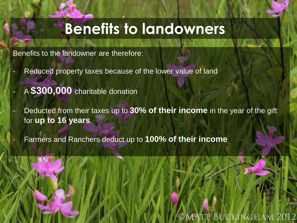
Benefits to landowners
Benefits to the landowner are therefore:
- Reduced property taxes because of the lower value of land
- A $300,000 charitable donation
- Deducted from their taxes up to 30% of their income in the year of the gift
for up to 16 years.
- Farmers and Ranchers deduct up to 100% of their income

Demonstration conservation easement value

Conservation Easement Options
Purchase:The land trust
raises funds and
purchases the
value of the
conservation
easement from
the landowner.
No tax deductions
are taken for
purchased
easements.
Donation:The landowner
donates the value
of the
conservation
easement to the
land trust and
benefits from the
charitable
donation with
federal tax
deductions.

Conservation Easement Options
Purchased Easements
Funding through:
Capital Campaigns
Grants - NRCS
Environmental Offsets

ENVIRONMENTAL OFFSETS

ENVIRONMENTAL OFFSETS
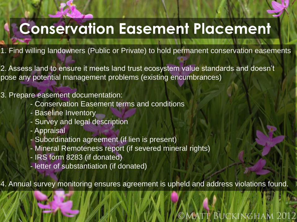
Conservation Easement Placement
1. Find willing landowners (Public or Private) to hold permanent conservation easements
2. Assess land to ensure it meets land trust ecosystem value standards and doesn’t
pose any potential management problems (existing encumbrances)
3. Prepare easement documentation:
- Conservation Easement terms and conditions
- Baseline Inventory
- Survey and legal description
- Appraisal
- Subordination agreement (if lien is present)
- Mineral Remoteness report (if severed mineral rights)
- IRS form 8283 (if donated)
- letter of substantiation (if donated)
4. Annual survey monitoring ensures agreement is upheld and address violations found.

STRATEGIC WETLAND MITIGATION
USED AT CURRY LAKE
AND OTHER SPRING CREEK PRESERVES

77 Acres
STRATEGIC WETLAND MITIGATION

19 Acres
STRATEGIC WETLAND MITIGATION

Waste Mgt.
7 Acres
STRATEGIC WETLAND MITIGATION

Entergy
1 Acre
STRATEGIC WETLAND MITIGATION

24 Acres
STRATEGIC WETLAND MITIGATION

128 ACRES TOTAL
CONNECTED,
STRATEGIC
WETLANDS MITIGATION
STRATEGIC WETLAND MITIGATION


Why Preserve Texas Land?
Family land of emotional relevance
Guarantee of Protection
Relieve financial strain of ownership: property tax or estate tax
Access to Federal or State money for management or acquisition

Why Preserve Texas Land?
• 95.8% of land in Texas is privately owned - three times more than any other state!
• The population in Texas is expected to increase 82% by 2060, with development
pressure heaviest near urban areas.
• Surface water - streams, reservoirs and rivers - are an increasingly threatened
source due to drought, development pressure and population growth.
• The total acreage of protected land in Texas, including state and local parks, is
only 3,000,000. Texas is losing its rural lands faster than any other state in the
nation.

HOW SURVEYORS CAN WORK WITH LAND TRUSTSSurvey and metes and bounds for
conservation easement area is required for
every CE
purchased by landowner, or
tax deductible if donated to land trust
Boundary re-verification for existing CE’s
important for boundary dispute
violation to CE near boundaries

Digital Data Needed!Mapping of baseline conditions
Annual survey
Handheld GPS for monitoring
and reporting

AUTOCAD DWG AND SHPConverting georeferenced .dwg files to ArcGIS .shp files

Open CAD files directly
in ArcGIS


DWG CONVERT TO SHP

Within AutoCAD you can
export boundary data to
ArcGIS shapefile:
Define the coordinate system
the MAPEXPORT command
Output file type to “ESRI Shapefile
(*.shp)”
Set the object type, object data
tables, coordinate system
Select the DWG and correlate the
object type to this selection: point,
line, polygon. Export one at a time.
Select the associated Metadata

AUTOCAD DWG AND
SHPAutoCAD and ArcGIS


SURVEY AND SHPAutoCAD and ArcGIS
