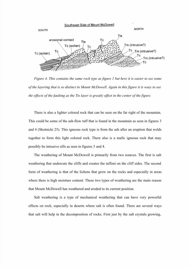
taysom james final
TRANSCRIPT
8/8/2019 Taysom James Final
http://slidepdf.com/reader/full/taysom-james-final 1/11
8/8/2019 Taysom James Final
http://slidepdf.com/reader/full/taysom-james-final 2/11
8/8/2019 Taysom James Final
http://slidepdf.com/reader/full/taysom-james-final 3/11
8/8/2019 Taysom James Final
http://slidepdf.com/reader/full/taysom-james-final 4/11
8/8/2019 Taysom James Final
http://slidepdf.com/reader/full/taysom-james-final 5/11
8/8/2019 Taysom James Final
http://slidepdf.com/reader/full/taysom-james-final 6/11
8/8/2019 Taysom James Final
http://slidepdf.com/reader/full/taysom-james-final 7/11
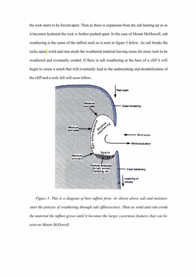
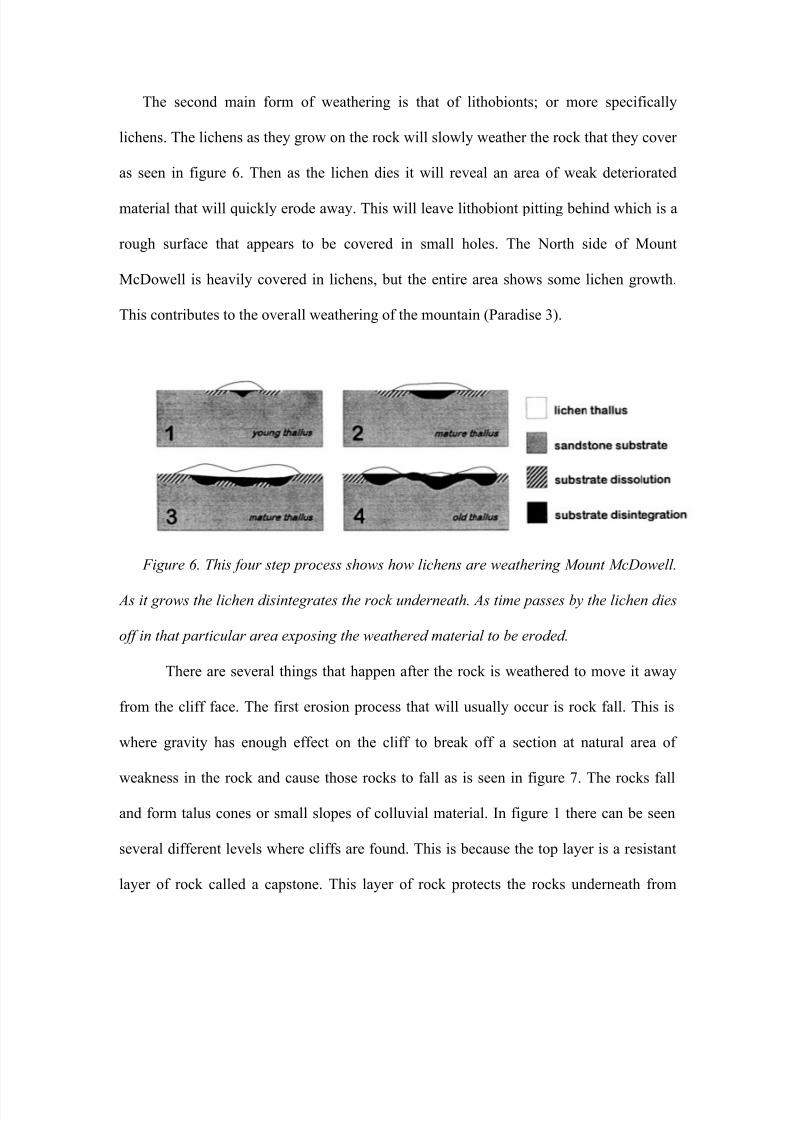
The second main form of weathering is that of lithobionts; or more specifically
lichens. The lichens as they grow on the rock will slowly weather the rock that they cover
as seen in figure 6. Then as the lichen dies it will reveal an area of weak deteriorated
material that will quickly erode away. This will leave lithobiont pitting behind which is a
rough surface that appears to be covered in small holes. The North side of Mount
McDowell is heavily covered in lichens, but the entire area shows some lichen growth.
This contributes to the overall weathering of the mountain (Paradise 3).
Figure 6. This four step process shows how lichens are weathering Mount McDowell.
As it grows the lichen disintegrates the rock underneath. As time passes by the lichen dies
off in that particular area exposing the weathered material to be eroded.
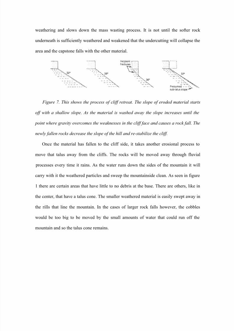
There are several things that happen after the rock is weathered to move it away
from the cliff face. The first erosion process that will usually occur is rock fall. This is
where gravity has enough effect on the cliff to break off a section at natural area of
weakness in the rock and cause those rocks to fall as is seen in figure 7. The rocks falland form talus cones or small slopes of colluvial material. In figure 1 there can be seen
several different levels where cliffs are found. This is because the top layer is a resistant
layer of rock called a capstone. This layer of rock protects the rocks underneath from
8/8/2019 Taysom James Final
http://slidepdf.com/reader/full/taysom-james-final 8/11
weathering and slows down the mass wasting process. It is not until the softer rock
underneath is sufficiently weathered and weakened that the undercutting will collapse the
area and the capstone falls with the other material.
Figure 7. This shows the process of cliff retreat. The slope of eroded material starts
off with a shallow slope. As the material is washed away the slope increases until the
point where gravity overcomes the weaknesses in the cliff face and causes a rock fall. The
newly fallen rocks decrease the slope of the hill and re-stabilize the cliff.
Once the material has fallen to the cliff side, it takes another erosional process to
move that talus away from the cliffs. The rocks will be moved away through fluvial
processes every time it rains. As the water runs down the sides of the mountain it will
carry with it the weathered particles and sweep the mountainside clean. As seen in figure
1 there are certain areas that have little to no debris at the base. There are others, like in
the center, that have a talus cone. The smaller weathered material is easily swept away in
the rills that line the mountain. In the cases of larger rock falls however, the cobbles
would be too big to be moved by the small amounts of water that could run off the
mountain and so the talus cone remains.
8/8/2019 Taysom James Final
http://slidepdf.com/reader/full/taysom-james-final 9/11
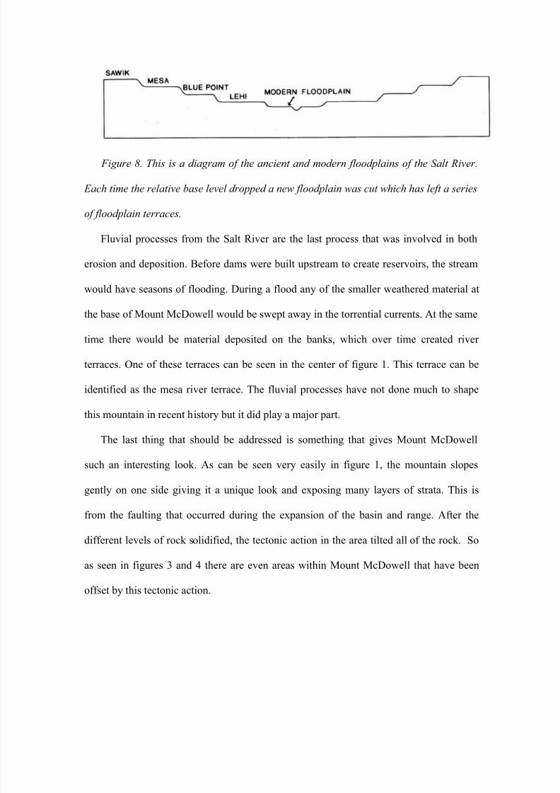
Figure 8. This is a diagram of the ancient and modern floodplains of the Salt River.
Each time the relative base level dropped a new floodplain was cut which has left a series
of floodplain terraces.
Fluvial processes from the Salt River are the last process that was involved in both
erosion and deposition. Before dams were built upstream to create reservoirs, the stream
would have seasons of flooding. During a flood any of the smaller weathered material at
the base of Mount McDowell would be swept away in the torrential currents. At the same
time there would be material deposited on the banks, which over time created river
terraces. One of these terraces can be seen in the center of figure 1. This terrace can be
identified as the mesa river terrace. The fluvial processes have not done much to shape
this mountain in recent history but it did play a major part.
The last thing that should be addressed is something that gives Mount McDowell
such an interesting look. As can be seen very easily in figure 1, the mountain slopes
gently on one side giving it a unique look and exposing many layers of strata. This is
from the faulting that occurred during the expansion of the basin and range. After the
different levels of rock solidified, the tectonic action in the area tilted all of the rock. So
as seen in figures 3 and 4 there are even areas within Mount McDowell that have been
offset by this tectonic action.
8/8/2019 Taysom James Final
http://slidepdf.com/reader/full/taysom-james-final 10/11
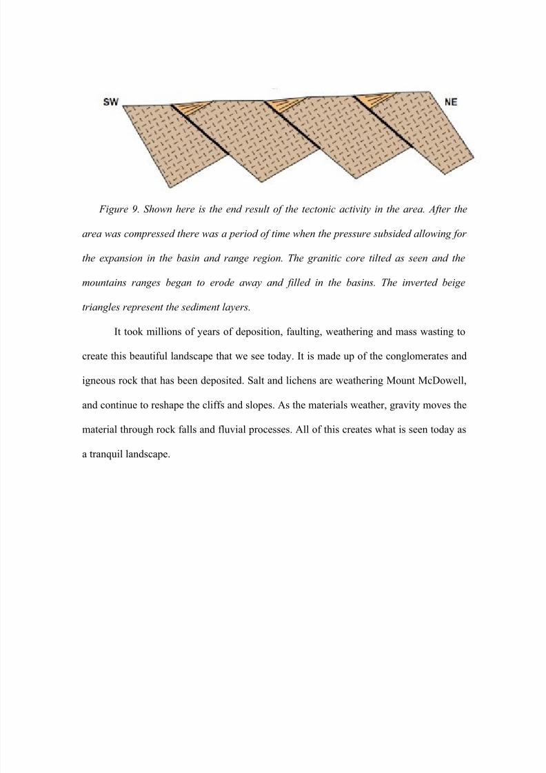
Figure 9. Shown here is the end result of the tectonic activity in the area. After the
area was compressed there was a period of time when the pressure subsided allowing for
the expansion in the basin and range region. The granitic core tilted as seen and the
mountains ranges began to erode away and filled in the basins. The inverted beige
triangles represent the sediment layers.
It took millions of years of deposition, faulting, weathering and mass wasting to
create this beautiful landscape that we see today. It is made up of the conglomerates and
igneous rock that has been deposited. Salt and lichens are weathering Mount McDowell,
and continue to reshape the cliffs and slopes. As the materials weather, gravity moves the
material through rock falls and fluvial processes. All of this creates what is seen today as
a tranquil landscape.
8/8/2019 Taysom James Final
http://slidepdf.com/reader/full/taysom-james-final 11/11
Arrowsmith, Ramon. "Paleochannels of the Salt River: Evaluation of recharge potential."15 11 1999. ASU. 10 Dec 2008http://activetectonics.asu.edu/Environmental_Geophysics/fig1geo.GIF
Dorn, Ron. "Salt River Terraces." ASU. 10 Dec 2008http://www.asu.edu/courses/gph111/Fluvial/SaltRiverTerraces.GIF
Dorn, Ron. "Lecture on Weathering." 10 Dec 2008http://alliance.la.asu.edu/gph211/breeze/PublishWeathSoils/index.htm
Howard, Alan. "Introduction to Cuesta Landforms and Sapping Processes on theColorado Plateau." 1988. 10 Dec 2008http://erode.evsc.virginia.edu/papers/howard_colo_plat_88.pdf
Reynolds, Stephen. "Subsurface geology of the easternmost Phoenix ." Aug2002. Arizona Geological Survey . 10 Dec 2008http://reynolds.asu.edu/pubs/phx_basin_subsurface_final.pdf
Paradise, Thomas. "DISPARATE SANDSTONE WEATHERING BENEATH ."1997. University of Hawaii Hilo. 10 Dec 2008 http://www.jstor.org/stable/521309
Skontnicki, Steven. "Geologic Map of The Fountain Hills / Mount McDowellArea, Maricopa County, Arizona."Arizona Geologic Survey. 1995.