take the challenge. - sonoma county regional...
TRANSCRIPT
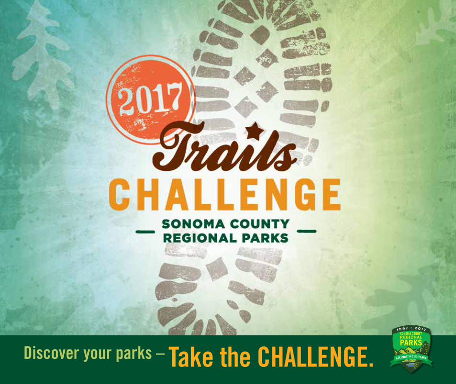
Discover your parks – Take the CHALLENGE.
CHALLENGEWELCOME TO THE SONOMA COUNTY TRAILS CHALLENGE, an invitation to explore the Regional Parks and do something good for your body and mind!
S�noma County has more than 50 Regional Parks with more than 150 miles of trails for walking, running, biking, and horseback riding. Take the Trails Challenge and discover the beauty of Sonoma County and the healthy fun of trail sports by hiking, biking, or riding five or more of the routes featured in this guidebook from June through September.
The Trails Challenge is free and designed for all fitness levels. You can take the Trails Challenge on your own, with your dog, with family and friends, with co-workers, or as part of a guided outing.
If you’ve taken the Trails Challenge before,
we invite you to try new itineraries at Hood Mountain, Cloverdale River Park, West County Trail, Maxwell Farms, North Sonoma Mountain, and Shorttail Gulch.
HOW TO TAKE THE CHALLENGEDownload the Trails Challenge guidebook at sonomacountyparks.org. (Limited print editions are available at Regional Parks’ office, 2300 County Center Drive, Suite 120A, in Santa Rosa, and at staffed entries to Spring Lake and Ragle Ranch parks.)• Select 5 or more hikes to complete by Sept. 30.• When you finish all 5, fill out the brief trails log at sonomacountyparks.org.• Get your free Trails Challenge t-shirt (while supplies last.) Kids also get a new nature-themed book selected by the
Sonoma County Library.• Post a Trails Challenge photo on Facebook or Instagram with #SonomaCountyParks #TrailsChallenge,
to be eligible for monthly giveaways of REI gear and parks memberships.
Discover your parks
SONOMACOUNTYRE
GION
AL PARKS
sonomaCOAST
valleys+VIEWS
russianRIVER
2017 REGIONAL PARKS TRAIL CHALLENGE | SONOMA COUNTY | 3
PARKSSONOMACOUNTY
RIVER
Discover your parks LET’S GET STARTEDHIKING FOR HEALTH
Experts agree that walking is one of the simplest, most effective actions we can take to improve our health. Walking at least 30 minutes a day can help us lose or maintain weight, lessen our risks for diabetes, heart disease, osteoporosis and certain cancers, and improve our moods and sleep.
DISCOVER YOUR PARKSThe Trails Challenge is a great way to explore the diversity of Sonoma County’s parks, where trails lead to mountains, beaches, forests, rivers, meadows and lakes. These hikes let you experience these special landscapes. Odds are you’ll discover a new favorite destination.
HIKING TIPS• Wear sturdy, comfortable athletic shoes. Dress in layers. Sonoma
County’s microclimates mean a walk that starts with cloudy, cool weather may end with clear skies and warm temperatures.
• Carry a map of the parks. If you don’t have a print or downloadedmap, snap a picture of the trailhead map with your smartphone.
• Bring a full water bottle. Drink before, during and after your hike.
• Avoid mid-day and afternoon hikes when temperatures are high.
• Wear sunscreen, even on overcast days, and bring a hatand sunglasses.
• Start out slowly and give your muscles time to warm up. Knowyour limits. Don’t overexert.
TRAIL ETIQUETTE• Walk on the right side of the trail. Bikers yield to hikers. Bikers and
hikers yield to horseback riders.
• Respect others’ enjoyment of the quiet of the parks.
• Use garbage cans along the trail or pack out trash to the parking lot.Always pick up after your dog.
• Please don’t pick flowers and plants or disturb streams and lakes.
HIKING WITH DOGS Dogs love hiking just as much as people do and are allowed on all Regional Parks trails except at Shiloh Ranch and North Sonoma Mountain. Please keep your dog on leash and carry water, a portable bowl, and waste bags.
HIKING WITH KIDS Hikes are a wonderful family activity, and the Trails Challenge is perfect for summer adventures. Kids love exploring the outdoors and can feel a real sense of accomplishment after a hike.
• Like any outing with children, hikes take advance planning. Knowthe length of your route and whether it’s suitable for your child’sabilities. Start with short hikes and work up to longer outings.
• Kids take lots of breaks to examine things. Use these moments tomake simple observations and talk about what you’re seeing.
WILDLIFE – The wildlife you’re most likely to see in the parks are deer, squirrels, lizards, turkeys, hawks, eagles, and many other bird species and grazing livestock. Infrequently, you might see non-venomous garter and gopher snakes. Even more rarely, you might see a rattlesnake, bobcat, coyote, or mountain lion. Don’t intentionally approach animals. If you encounter a snake, move away, and it likely will move away too.
TICKS – Ticks can be found all year in Sonoma County. Wear an effective repellent and always check yourself and your pets for ticks after being on trails.
POISON OAK – Poison oak is abundant in some parks. Fortunately, it’s easy to identify by its smooth, shiny leaves growing in threes. (“Leaves of three, leave them be.”) If you come into contact with poison oak, wash your hands with soap and water as soon as possible.

4 | 2017 REGIONAL PARKS TRAIL CHALLENGE | SONOMA COUNTY
TRAIL RATINGS
EASY TRAILS – Easy trails are under 3 miles and relatively flat with room to walk side by side with a companion.
Cloverdale River Park, Cloverdale — 2.25 miles round tripMaxwell Farms, Sonoma — 1.3 miles round tripSpring Lake, Santa Rosa — 2.3 miles round tripRagle Ranch, Sebastopol — 1.65 miles round tripRiverfront, Windsor — 2.18 or 2.68 miles round tripThe Sea Ranch Coastal Access Trails — .24 to 1.3 miles round trip
MODERATE TRAILS – Moderate-intensity trails are more than 3 miles or have varied terrain and elevation gains. Moderate-level hikes can be created by combining shorter trail loops within a park.
Bluff Top Trail, The Sea Ranch — 6 miles round tripHelen Putnam, Petaluma — 2.8 or 3.3 miles round tripHood Mountain, Santa Rosa Creek Trail - 2.2 miles round tripShorttail or Pinnacle Gulch, Bodega Bay — 1.29 miles round trip Stillwater Cove, north of Jenner — 1.2 miles round tripWest County Trail, Santa Rosa — 4.6 miles round trip
STRENUOUS TRAILS – Strenuous trails are 5 miles or longer or feature steep climbs or rugged terrain. These trails are recommended for experienced hikers in good physical condition.
Hood Mountain, Santa Rosa/Kenwood — 5 to 9 miles round tripFoothill, Windsor — 3 miles round trip North Sonoma Mountain Ridge Trail — 7.4 miles round tripShiloh Ranch, Windsor — 4.2 miles round tripTaylor Mountain, Santa Rosa — 5 to 8.2 miles round trip
TRAIL THEMES
Create a themed Trails Challenge with the following itineraries:
FAMILY-FRIENDLY HIKES Hood Mountain, Santa Rosa Creek Trail — 2.2 miles round tripMaxwell Farms, Sonoma — 1.3 miles round tripCloverdale River Park, Cloverdale - 2.25 miles round tripRagle Ranch, Sebastopol — 1.65 miles round tripSpring Lake Regional Park, Santa Rosa - 2.3 miles round trip
MOUNTAIN HIKES (elevation gains)North Sonoma Mountain Ridge Trail, Santa Rosa — 2,097 feet Hood Mountain, Santa Rosa/Kenwood — 2,000-2,700 feet Shiloh Ranch, Windsor — 1,157 feet Foothill, Windsor — 770 feet Taylor Mountain, Santa Rosa — 1,100 feet
HABITAT HIKES Stillwater Cove, north of Jenner – redwoods – 1.2 miles round tripCloverdale River Park, Cloverdale – riparian forest – 2.25 miles round tripBluff Top Trail, The Sea Ranch – coastal prairie – 6 miles round tripHelen Putnam, Petaluma – oak savanna – 2.8 or 3.3 miles round tripHood Mountain, Santa Rosa – pygmy forest – 6.7 miles round trip
50-MILE CHALLENGE – HIKE 50 FOR REGIONAL PARKS’ 50TH!Regional Parks turns 50 in 2017! Mark the occasion by hiking each of the 15 parks featured in this guide. When you’re done, you will have logged more than 50 miles! Are you up for it? Finishers are eligible for special giveaways at the end of the Challenge.
Walk/Hike/Run – Trail open to pedestrians.
Wheels – Paved trails; Wheelchair accessible and suitable for strollers.
Dogs – Dogs on leash welcome.
Bike – Trail open to cyclists.
Equestrians – Trail open to horseback riders.

2017 REGIONAL PARKS TRAIL CHALLENGE | SONOMA COUNTY | 5
B E C O M E A M E M B E R !
Become a Regional Parks Member and pay once to park all year at any of your Sonoma County parks! + Free night of camping + Festival admission
PARKS MEMBERSHIPSAn annual membership is the easiest, most affordable way to regularly enjoy the Regional Parks. For $69 a year - less than $6 a month - a membership includes 12 months of parking at all Regional Parks, one night of camping, and family admission to the Tolay Fall Festival for two adults and two children. Membership discounts are available for seniors and people with permanent disabilities.
GUIDED HIKESWe’re offering a variety of guided hikes for the Trails Challenge. Come along on these group outings and learn about the plants, wildlife and history of the parks. Visit the activities calendar at sonomacountyparks.org to join us! We’ll also announce the hikes on Facebook and Instagram, so be sure to follow us.
Reading CHALLENGEMake the Trails Challenge an adventure for body and mind by enjoying a reading list suggested by the Sonoma County Library. (See the Trails Challenge page at sonomacountyparks.org.) Children who finish the Trails Challenge get a free book compliments of the Library and Regional Parks Foundations.
Sample Children’s Stories:Anne Mazer: The Salamander RoomAndrew Clements: A Week in the WoodsElizabeth Scanlon: In the Canyon
Sample Children’s Nonfiction:Jessica Loy: Follow the Trail: A Young Person’s Guide to the Great Outdoors
Marilyn Singer: A Stick is an Excellent ThingNancy Blakely: Go Outside: Over 130 Activities for Outdoor Adventures
Guidebooks for Adults: Robert Stone: Day Hikes Around Sonoma County: 125 Great Hikes
Sarah Cornelius: Walking Softly: A Collection of Mostly Gentle Walks in Sonoma County, CaliforniaStephen Hinch: Hiking and Adventure Guide to the Sonoma Coast and Russian River
6 | 2017 REGIONAL PARKS TRAIL CHALLENGE | SONOMA COUNTY
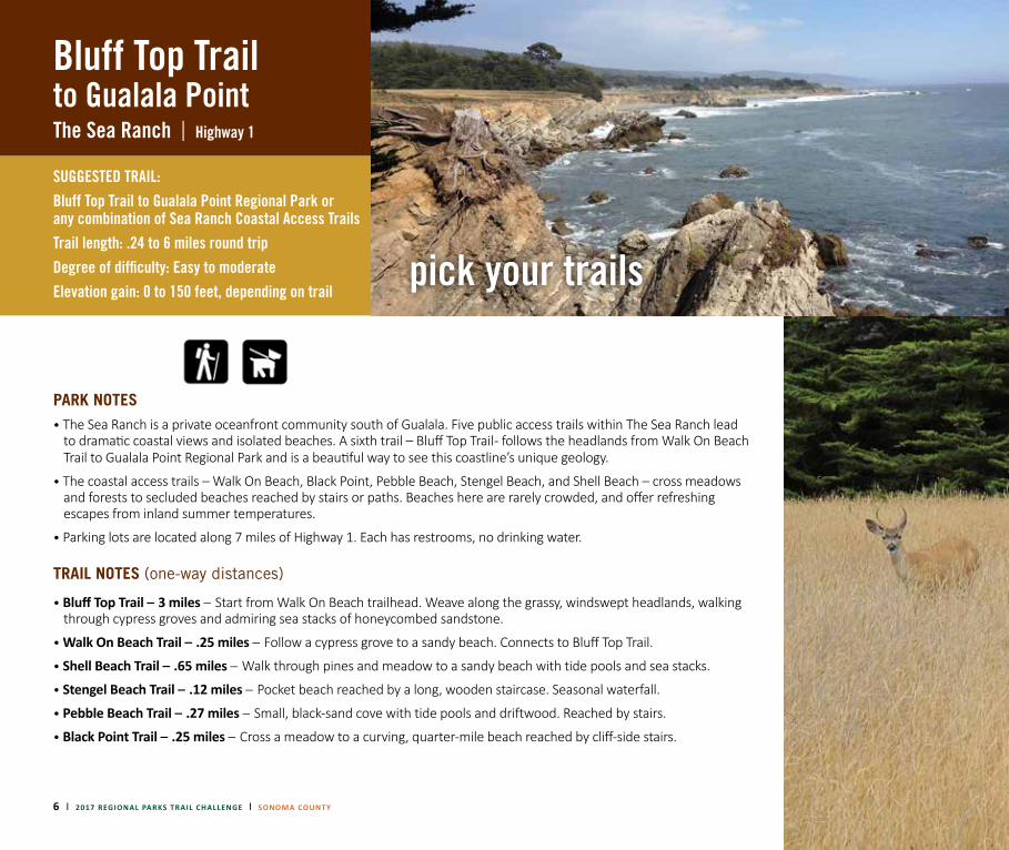
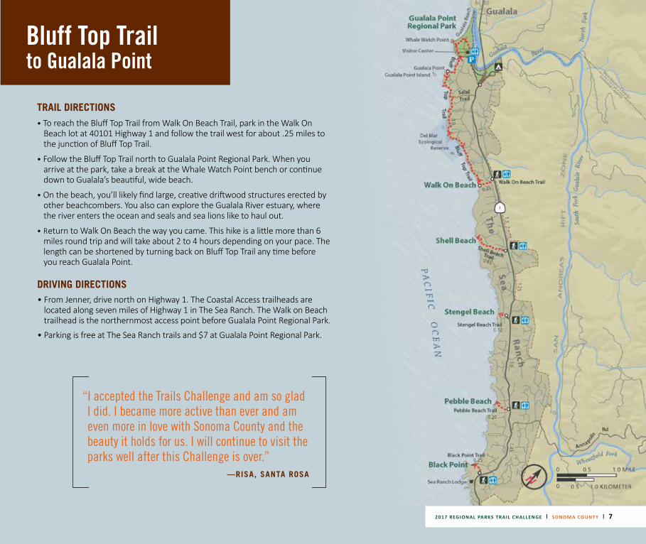
Bluff Top Trail to Gualala PointThe Sea Ranch | Highway 1
SUGGESTED TRAIL: Bluff Top Trail to Gualala Point Regional Park or any combination of Sea Ranch Coastal Access TrailsTrail length: .24 to 6 miles round trip
Degree of difficulty: Easy to moderate Elevation gain: 0 to 150 feet, depending on trail
PARK NOTES• The Sea Ranch is a private oceanfront community south of Gualala. Five public access trails within The Sea Ranch lead
to dramatic coastal views and isolated beaches. A sixth trail – Bluff Top Trail - follows the headlands from Walk On Beach Trail to Gualala Point Regional Park and is a beautiful way to see this coastline’s unique geology.
• The coastal access trails – Walk On Beach, Black Point, Pebble Beach, Stengel Beach, and Shell Beach – cross meadows and forests to secluded beaches reached by stairs or paths. Beaches here are rarely crowded, and offer refreshing escapes from inland summer temperatures.
• Parking lots are located along 7 miles of Highway 1. Each has restrooms, no drinking water.
TRAIL NOTES (one-way distances)
• Bluff Top Trail – 3 miles – Start from Walk On Beach trailhead. Weave along the grassy, windswept headlands, walking through cypress groves and admiring sea stacks of honeycombed sandstone.
• Walk On Beach Trail – .25 miles – Follow a cypress grove to a sandy beach. Connects to Bluff Top Trail.
• Shell Beach Trail – .65 miles – Walk through pines and meadow to a sandy beach with tide pools and sea stacks.
• Stengel Beach Trail – .12 miles – Pocket beach reached by a long, wooden staircase. Seasonal waterfall.
• Pebble Beach Trail – .27 miles
– Small, black-sand cove with tide pools and driftwood. Reached by stairs.
• Black Point Trail – .25 miles – Cross a meadow to a curving, quarter-mile beach reached by cliff-side stairs.
pick your trails
Bluff Top Trail to Gualala Point
TRAIL DIRECTIONS• To reach the Bluff Top Trail from Walk On Beach Trail, park in the Walk On
Beach lot at 40101 Highway 1 and follow the trail west for about .25 miles to the junction of Bluff Top Trail.
• Follow the Bluff Top Trail north to Gualala Point Regional Park. When you arrive at the park, take a break at the Whale Watch Point bench or continue down to Gualala’s beautiful, wide beach.
• On the beach, you’ll likely find large, creative driftwood structures erected by other beachcombers. You also can explore the Gualala River estuary, where the river enters the ocean and seals and sea lions like to haul out.
• Return to Walk On Beach the way you came. This hike is a little more than 6 miles round trip and will take about 2 to 4 hours depending on your pace. The length can be shortened by turning back on Bluff Top Trail any time before you reach Gualala Point.
DRIVING DIRECTIONS• From Jenner, drive north on Highway 1. The Coastal Access trailheads are
located along seven miles of Highway 1 in The Sea Ranch. The Walk on Beach trailhead is the northernmost access point before Gualala Point Regional Park.
• Parking is free at The Sea Ranch trails and $7 at Gualala Point Regional Park.
“I accepted the Trails Challenge and am so glad I did. I became more active than ever and am even more in love with Sonoma County and the beauty it holds for us. I will continue to visit the parks well after this Challenge is over.”
—RISA, SANTA ROSA
2017 REGIONAL PARKS TRAIL CHALLENGE | SONOMA COUNTY | 7
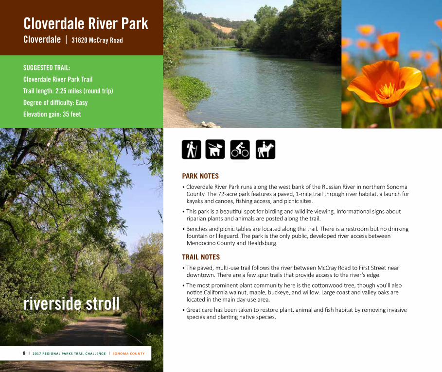
Cloverdale River ParkCloverdale | 31820 McCray Road
SUGGESTED TRAIL:
Cloverdale River Park Trail
Trail length: 2.25 miles (round trip)
Degree of difficulty: Easy
Elevation gain: 35 feet
PARK NOTES• Cloverdale River Park runs along the west bank of the Russian River in northern Sonoma
County. The 72-acre park features a paved, 1-mile trail through river habitat, a launch for kayaks and canoes, fishing access, and picnic sites.
• This park is a beautiful spot for birding and wildlife viewing. Informational signs about riparian plants and animals are posted along the trail.
• Benches and picnic tables are located along the trail. There is a restroom but no drinking fountain or lifeguard. The park is the only public, developed river access between Mendocino County and Healdsburg.
TRAIL NOTES• The paved, multi-use trail follows the river between McCray Road to First Street near
downtown. There are a few spur trails that provide access to the river’s edge.
• The most prominent plant community here is the cottonwood tree, though you’ll also notice California walnut, maple, buckeye, and willow. Large coast and valley oaks are located in the main day-use area.
• Great care has been taken to restore plant, animal and fish habitat by removing invasive species and planting native species.
riverside stroll
8 | 2017 REGIONAL PARKS TRAIL CHALLENGE | SONOMA COUNTY
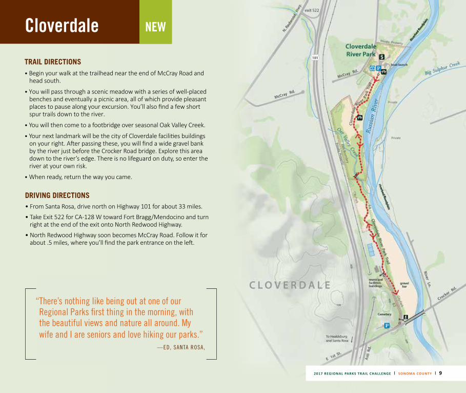
Cloverdale
2017 REGIONAL PARKS TRAIL CHALLENGE | SONOMA COUNTY | 9
NEW
TRAIL DIRECTIONS• Begin your walk at the trailhead near the end of McCray Road and
head south.
• You will pass through a scenic meadow with a series of well-placed benches and eventually a picnic area, all of which provide pleasant places to pause along your excursion. You’ll also find a few short spur trails down to the river.
• You will then come to a footbridge over seasonal Oak Valley Creek.
• Your next landmark will be the city of Cloverdale facilities buildings on your right. After passing these, you will find a wide gravel bank by the river just before the Crocker Road bridge. Explore this area down to the river’s edge. There is no lifeguard on duty, so enter the river at your own risk.
• When ready, return the way you came.
DRIVING DIRECTIONS• From Santa Rosa, drive north on Highway 101 for about 33 miles.
• Take Exit 522 for CA-128 W toward Fort Bragg/Mendocino and turn right at the end of the exit onto North Redwood Highway.
• North Redwood Highway soon becomes McCray Road. Follow it for about .5 miles, where you’ll find the park entrance on the left.
“ There’s nothing like being out at one of our Regional Parks first thing in the morning, with the beautiful views and nature all around. My wife and I are seniors and love hiking our parks.”
—ED, SANTA ROSA,
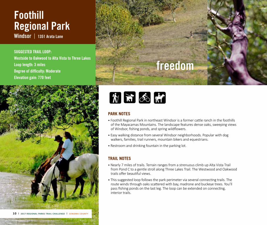
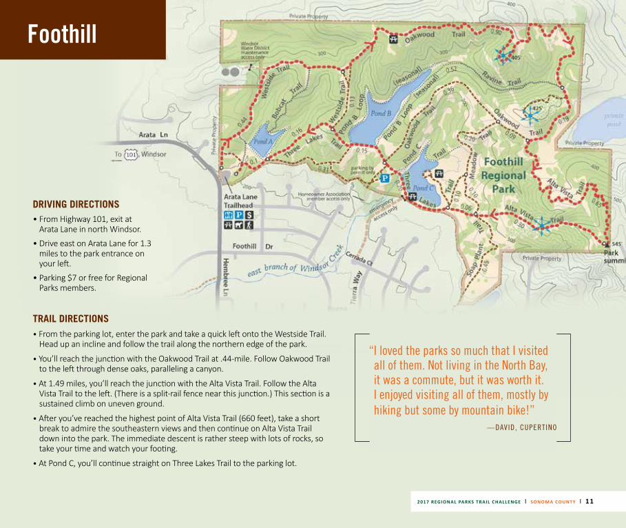
Foothill Regional ParkWindsor | 1351 Arata Lane
SUGGESTED TRAIL LOOP:
Westside to Oakwood to Alta Vista to Three Lakes Loop length: 3 miles Degree of difficulty: Moderate Elevation gain: 770 feet
10 | 2017 REGIONAL PARKS TRAIL CHALLENGE | SONOMA COUNTY
PARK NOTES• Foothill Regional Park in northeast Windsor is a former cattle ranch in the foothills
of the Mayacamas Mountains. The landscape features dense oaks, sweeping views of Windsor, fishing ponds, and spring wildflowers.
• Easy walking distance from several Windsor neighborhoods. Popular with dog walkers, families, trail runners, mountain bikers and equestrians.
• Restroom and drinking fountain in the parking lot.
TRAIL NOTES• Nearly 7 miles of trails. Terrain ranges from a strenuous climb up Alta Vista Trail
from Pond C to a gentle stroll along Three Lakes Trail. The Westwood and Oakwood trails offer beautiful views.
• This suggested loop follows the park perimeter via several connecting trails. The route winds through oaks scattered with bay, madrone and buckeye trees. You’ll pass fishing ponds on the last leg. The loop can be extended on connecting, interior trails.
freedom
2017 REGIONAL PARKS TRAIL CHALLENGE | SONOMA COUNTY | 11
Foothill
TRAIL DIRECTIONS• From the parking lot, enter the park and take a quick left onto the Westside Trail.
Head up an incline and follow the trail along the northern edge of the park.
• You’ll reach the junction with the Oakwood Trail at .44-mile. Follow Oakwood Trail to the left through dense oaks, paralleling a canyon.
• At 1.49 miles, you’ll reach the junction with the Alta Vista Trail. Follow the Alta Vista Trail to the left. (There is a split-rail fence near this junction.) This section is a sustained climb on uneven ground.
• After you’ve reached the highest point of Alta Vista Trail (660 feet), take a short break to admire the southeastern views and then continue on Alta Vista Trail down into the park. The immediate descent is rather steep with lots of rocks, so take your time and watch your footing.
• At Pond C, you’ll continue straight on Three Lakes Trail to the parking lot.
DRIVING DIRECTIONS• From Highway 101, exit at
Arata Lane in north Windsor.
• Drive east on Arata Lane for 1.3 miles to the park entrance on your left.
• Parking $7 or free for Regional Parks members.
“ I loved the parks so much that I visited all of them. Not living in the North Bay, it was a commute, but it was worth it. I enjoyed visiting all of them, mostly by hiking but some by mountain bike!”
—DAVID, CUPERTINO
12 | 2017 REGIONAL PARKS TRAIL CHALLENGE | SONOMA COUNTY
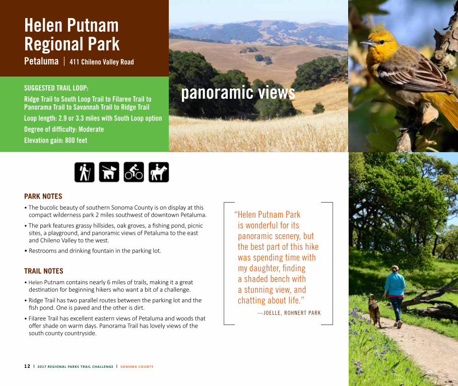
Helen Putnam Regional ParkPetaluma | 411 Chileno Valley Road
SUGGESTED TRAIL LOOP: Ridge Trail to South Loop Trail to Filaree Trail to Panorama Trail to Savannah Trail to Ridge Trail Loop length: 2.9 or 3.3 miles with South Loop option Degree of difficulty: Moderate Elevation gain: 800 feet
PARK NOTES• The bucolic beauty of southern Sonoma County is on display at this
compact wilderness park 2 miles southwest of downtown Petaluma.
• The park features grassy hillsides, oak groves, a fishing pond, picnic sites, a playground, and panoramic views of Petaluma to the east and Chileno Valley to the west.
• Restrooms and drinking fountain in the parking lot.
TRAIL NOTES• Helen Putnam contains nearly 6 miles of trails, making it a great
destination for beginning hikers who want a bit of a challenge.
• Ridge Trail has two parallel routes between the parking lot and the fish pond. One is paved and the other is dirt.
• Filaree Trail has excellent eastern views of Petaluma and woods that offer shade on warm days. Panorama Trail has lovely views of the south county countryside.
“ Helen Putnam Park is wonderful for its panoramic scenery, but the best part of this hike was spending time with my daughter, finding a shaded bench with a stunning view, and chatting about life.”
—JOELLE, ROHNERT PARK
panoramic views
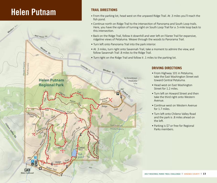
Helen Putnam TRAIL DIRECTIONS
• From the parking lot, head west on the unpaved Ridge Trail. At .3 miles you’ll reach the fish pond.
• Continue north on Ridge Trail to the intersection of Panorama and South Loop trails. Here, you have the option of turning right on South Loop Trail for a .5-mile loop back to this intersection.
• Back on the Ridge Trail, follow it downhill and veer left on Filaree Trail for expansive, ridgeline views of Petaluma. Weave through the woods to Panorama Trail.
• Turn left onto Panorama Trail into the park interior.
• At .3 miles, turn right onto Savannah Trail, take a moment to admire the view, and follow Savannah Trail .8 miles to the Ridge Trail.
• Turn right on the Ridge Trail and follow it .1 miles to the parking lot.
DRIVING DIRECTIONS• From Highway 101 in Petaluma,
take the East Washington Street exit toward Central Petaluma.
• Head west on East Washington Street for 1.2 miles.
• Turn left on Howard Street and then take the third right onto Western Avenue.
• Continue west on Western Avenue for 1.7 miles.
• Turn left onto Chileno Valley Road and the park is .8 miles ahead on the left.
• Parking is $7 or free for Regional Parks members.
2017 REGIONAL PARKS TRAIL CHALLENGE | SONOMA COUNTY | 13
14 | 2017 REGIONAL PARKS TRAIL CHALLENGE | SONOMA COUNTY
Hood Mountain Regional ParkSanta Rosa |
||
3000 Los Alamos Road
Santa Rosa 1450 Pythian Road
Kenwood Via Sugarloaf Ridge State Park, 2605 Adobe Canyon Rd.
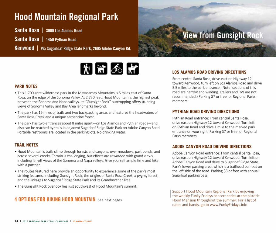
PARK NOTES• This 1,700-acre wilderness park in the Mayacamas Mountains is 5 miles east of Santa
Rosa, on the edge of the Sonoma Valley. At 2,730 feet, Hood Mountain is the highest peak between the Sonoma and Napa valleys. Its “Gunsight Rock” outcropping offers stunning views of Sonoma Valley and Bay Area landmarks beyond.
• The park has 19 miles of trails and two backpacking areas and features the headwaters of Santa Rosa Creek and a unique serpentine forest.
• The park has two entrances about 8 miles apart—on Los Alamos and Pythian roads—and also can be reached by trails in adjacent Sugarloaf Ridge State Park on Adobe Canyon Road. Portable restrooms are located in the parking lots. No drinking water.
TRAIL NOTES• Hood Mountain’s trails climb through forests and canyons, over meadows, past ponds, and
across several creeks. Terrain is challenging, but efforts are rewarded with grand views, including far-off views of the Sonoma and Napa valleys. Give yourself ample time and hike with a partner.
• The routes featured here provide an opportunity to experience some of the park’s most striking features, including Gunsight Rock, the origins of Santa Rosa Creek, a pygmy forest, and the linkages to Sugarloaf Ridge State Park and its Grandmother Tree.
• The Gunsight Rock overlook lies just southwest of Hood Mountain’s summit.
4 OPTIONS FOR HIKING HOOD MOUNTAIN See next pages
LOS ALAMOS ROAD DRIVING DIRECTIONS From central Santa Rosa, drive east on Highway 12 toward Kenwood, turn left on Los Alamos Road and drive 5.5 miles to the park entrance. (Note: sections of this road are narrow and winding. Trailers and RVs are not recommended.) Parking $7 or free for Regional Parks members.
PYTHIAN ROAD DRIVING DIRECTIONS Pythian Road entrance: From central Santa Rosa, drive east on Highway 12 toward Kenwood. Turn left on Pythian Road and drive 1 mile to the marked park entrance on your right. Parking $7 or free for Regional Parks members.
ADOBE CANYON ROAD DRIVING DIRECTIONS Adobe Canyon Road entrance: From central Santa Rosa, drive east on Highway 12 toward Kenwood. Turn left on Adobe Canyon Road and drive to Sugarloaf Ridge State Park’s lower parking area, which is a trailhead pull-out on the left side of the road. Parking $8 or free with annual Sugarloaf parking pass.
Support Hood Mountain Regional Park by enjoying the weekly Funky Fridays concert series at the historic Hood Mansion throughout the summer: For a list of dates and bands, go to www.FunkyFridays.info
View from Gunsight Rock
2017 REGIONAL PARKS TRAIL CHALLENGE | SONOMA COUNTY | 15
Hood Mountain
2017 REGIONAL PARKS TRAIL CHALLENGE | SONOMA COUNTY | 15
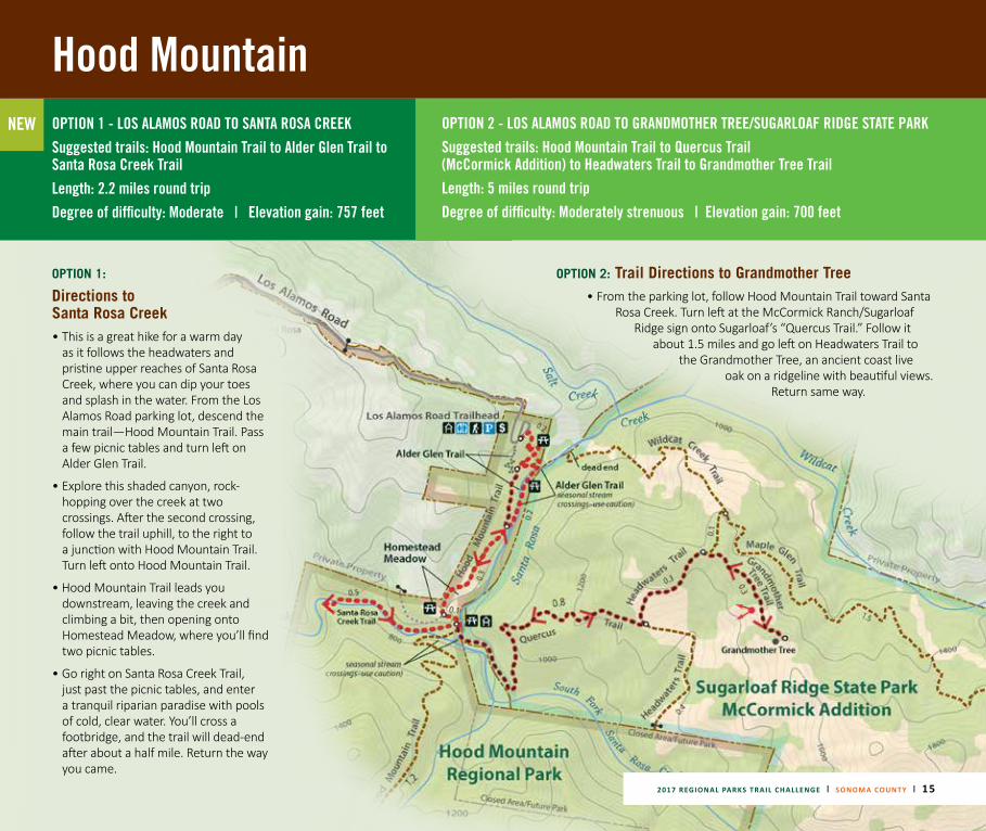
NEW OPTION 1 - LOS ALAMOS ROAD TO SANTA ROSA CREEK Suggested trails: Hood Mountain Trail to Alder Glen Trail to Santa Rosa Creek TrailLength: 2.2 miles round trip Degree of difficulty: Moderate | Elevation gain: 757 feet
OPTION 2 - LOS ALAMOS ROAD TO GRANDMOTHER TREE/SUGARLOAF RIDGE STATE PARKSuggested trails: Hood Mountain Trail to Quercus Trail (McCormick Addition) to Headwaters Trail to Grandmother Tree TrailLength: 5 miles round tripDegree of difficulty: Moderately strenuous | Elevation gain: 700 feet
OPTION 1:
Directions to Santa Rosa Creek• This is a great hike for a warm day
as it follows the headwaters and pristine upper reaches of Santa Rosa Creek, where you can dip your toes and splash in the water. From the Los Alamos Road parking lot, descend the main trail—Hood Mountain Trail. Pass a few picnic tables and turn left on Alder Glen Trail.
• Explore this shaded canyon, rock-hopping over the creek at two crossings. After the second crossing, follow the trail uphill, to the right to a junction with Hood Mountain Trail. Turn left onto Hood Mountain Trail.
• Hood Mountain Trail leads you downstream, leaving the creek and climbing a bit, then opening onto Homestead Meadow, where you’ll find two picnic tables.
• Go right on Santa Rosa Creek Trail, just past the picnic tables, and enter a tranquil riparian paradise with pools of cold, clear water. You’ll cross a footbridge, and the trail will dead-end after about a half mile. Return the way you came.
OPTION 2: Trail Directions to Grandmother Tree• From the parking lot, follow Hood Mountain Trail toward Santa
Rosa Creek. Turn left at the McCormick Ranch/Sugarloaf Ridge sign onto Sugarloaf’s “Quercus Trail.” Follow it
about 1.5 miles and go left on Headwaters Trail to the Grandmother Tree, an ancient coast live
oak on a ridgeline with beautiful views. Return same way.
Hood Mountain
Hood Mountain Summit2730 Feet
16 | 2017 REGIONAL PARKS TRAIL CHALLENGE | SONOMA COUNTY
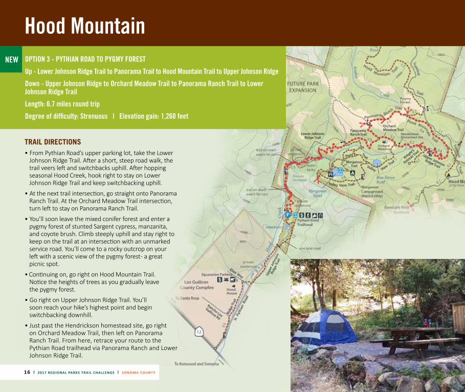
NEW OPTION 3 - PYTHIAN ROAD TO PYGMY FOREST
Up - Lower Johnson Ridge Trail to Panorama Trail to Hood Mountain Trail to Upper Johnson Ridge
Down - Upper Johnson Ridge to Orchard Meadow Trail to Panorama Ranch Trail to Lower Johnson Ridge Trail
Length: 6.7 miles round trip
Degree of difficulty: Strenuous | Elevation gain: 1,260 feet
TRAIL DIRECTIONS• From Pythian Road’s upper parking lot, take the Lower
Johnson Ridge Trail. After a short, steep road walk, the trail veers left and switchbacks uphill. After hopping seasonal Hood Creek, hook right to stay on Lower Johnson Ridge Trail and keep switchbacking uphill.
• At the next trail intersection, go straight onto Panorama Ranch Trail. At the Orchard Meadow Trail intersection, turn left to stay on Panorama Ranch Trail.
• You’ll soon leave the mixed conifer forest and enter a pygmy forest of stunted Sargent cypress, manzanita, and coyote brush. Climb steeply uphill and stay right to keep on the trail at an intersection with an unmarked service road. You’ll come to a rocky outcrop on your
left with a scenic view of the pygmy forest - a great picnic spot.
• Continuing on, go right on Hood Mountain Trail. Notice the heights of trees as you gradually leave the pygmy forest.
• Go right on Upper Johnson Ridge Trail. You’ll soon reach your hike’s highest point and begin switchbacking downhill.
• Just past the Hendrickson homestead site, go right on Orchard Meadow Trail, then left on Panorama Ranch Trail. From here, retrace your route to the Pythian Road trailhead via Panorama Ranch and Lower Johnson Ridge Trail.
Hood Mountain Summit2730 Feet
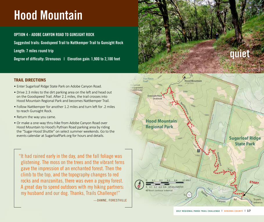
Hood MountainOPTION 4 - ADOBE CANYON ROAD TO GUNSIGHT ROCK
Suggested trails: Goodspeed Trail to Nattkemper Trail to Gunsight Rock
Length: 7 miles round trip
Degree of difficulty: Strenuous | Elevation gain: 1,900 to 2,100 feet
TRAIL DIRECTIONS • Enter Sugarloaf Ridge State Park on Adobe Canyon Road.
• Drive 2.3 miles to the dirt parking area on the left and head out on the Goodspeed Trail. After 2.1 miles, the trail crosses into Hood Mountain Regional Park and becomes Nattkemper Trail.
• Follow Nattkemper for another 1.2 miles and turn left for .2 miles to reach Gunsight Rock.
• Return the way you came.
• Or make a one-way thru-hike from Adobe Canyon Road over Hood Mountain to Hood’s Pythian Road parking area by riding the “Sugar-Hood Shuttle” on select summer weekends. Go to the events calendar at SugarloafPark.org for hours and details.
“ It had rained early in the day, and the fall foliage was glistening. The moss on the trees and the vibrant ferns gave the impression of an enchanted forest. Then the climb to the top, and the topography changes to red rocks and manzanitas, there was even a pygmy forest. A great day to spend outdoors with my hiking partners: my husband and our dog. Thanks, Trails Challenge!”
—DAWNE, FORESTVILLE
quiet
2017 REGIONAL PARKS TRAIL CHALLENGE | SONOMA COUNTY | 17
START
18 | 2017 REGIONAL PARKS TRAIL CHALLENGE | SONOMA COUNTY
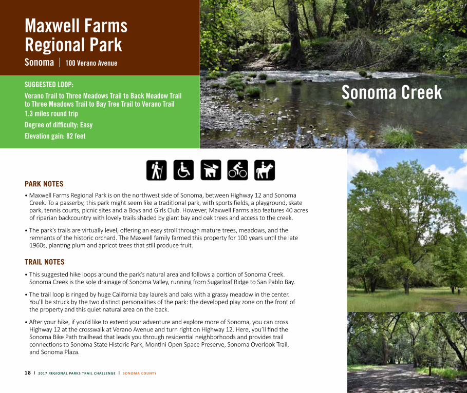
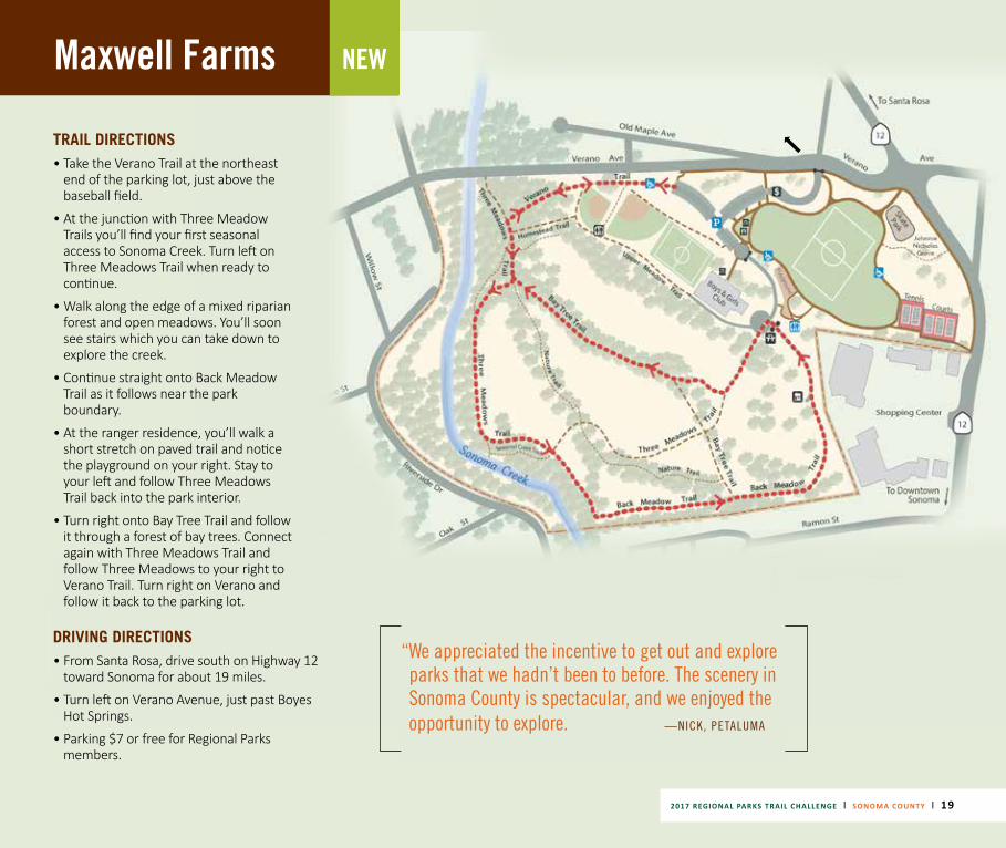
Maxwell Farms Regional ParkSonoma | 100 Verano Avenue
SUGGESTED LOOP: Verano Trail to Three Meadows Trail to Back Meadow Trail to Three Meadows Trail to Bay Tree Trail to Verano Trail 1.3 miles round trip Degree of difficulty: EasyElevation gain: 82 feet
PARK NOTES• Maxwell Farms Regional Park is on the northwest side of Sonoma, between Highway 12 and Sonoma
Creek. To a passerby, this park might seem like a traditional park, with sports fields, a playground, skate park, tennis courts, picnic sites and a Boys and Girls Club. However, Maxwell Farms also features 40 acres of riparian backcountry with lovely trails shaded by giant bay and oak trees and access to the creek.
• The park’s trails are virtually level, offering an easy stroll through mature trees, meadows, and the remnants of the historic orchard. The Maxwell family farmed this property for 100 years until the late 1960s, planting plum and apricot trees that still produce fruit.
Sonoma Creek
TRAIL NOTES
• This suggested hike loops around the park’s natural area and follows a portion of Sonoma Creek. Sonoma Creek is the sole drainage of Sonoma Valley, running from Sugarloaf Ridge to San Pablo Bay.
• The trail loop is ringed by huge California bay laurels and oaks with a grassy meadow in the center. You’ll be struck by the two distinct personalities of the park: the developed play zone on the front of the property and this quiet natural area on the back.
• After your hike, if you’d like to extend your adventure and explore more of Sonoma, you can cross Highway 12 at the crosswalk at Verano Avenue and turn right on Highway 12. Here, you’ll find the Sonoma Bike Path trailhead that leads you through residential neighborhoods and provides trail connections to Sonoma State Historic Park, Montini Open Space Preserve, Sonoma Overlook Trail, and Sonoma Plaza.
2017 REGIONAL PARKS TRAIL CHALLENGE | SONOMA COUNTY | 19
Maxwell Farms NEW
TRAIL DIRECTIONS• Take the Verano Trail at the northeast
end of the parking lot, just above the baseball field.
• At the junction with Three Meadow Trails you’ll find your first seasonal access to Sonoma Creek. Turn left on Three Meadows Trail when ready to continue.
• Walk along the edge of a mixed riparian forest and open meadows. You’ll soon see stairs which you can take down to explore the creek.
• Continue straight onto Back Meadow Trail as it follows near the park boundary.
• At the ranger residence, you’ll walk a short stretch on paved trail and notice the playground on your right. Stay to your left and follow Three Meadows Trail back into the park interior.
• Turn right onto Bay Tree Trail and follow it through a forest of bay trees. Connect again with Three Meadows Trail and follow Three Meadows to your right to Verano Trail. Turn right on Verano and follow it back to the parking lot.
DRIVING DIRECTIONS • From Santa Rosa, drive south on Highway 12
toward Sonoma for about 19 miles.
• Turn left on Verano Avenue, just past Boyes Hot Springs.
• Parking $7 or free for Regional Parks members.
“ We appreciated the incentive to get out and explore parks that we hadn’t been to before. The scenery in Sonoma County is spectacular, and we enjoyed the opportunity to explore. —NICK, PETALUMA
20 | 2017 REGI
ONAL PARKS TRAIL CHALLENGE | SONOMA COUNTY
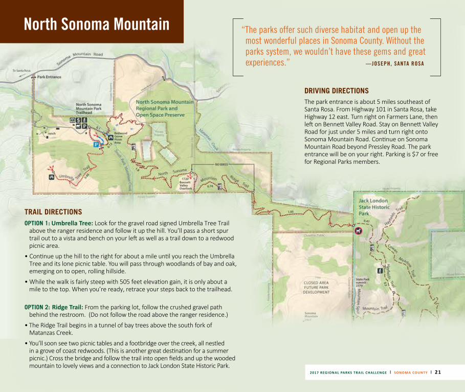
North Sonoma Mountain Regional Park & Open Space Preserve Santa Rosa | 5297 Sonoma Mountain Road
NEW OPTION 1 : UMBRELLA TREE TRAIL Length: 2 miles round tripDegree of difficulty: ModerateElevation gain: 505 feet
OPTION 2: NORTH SONOMA MOUNTAIN RIDGE TRAILLength: 7.4 miles round tripDegree of difficulty: Moderate/StrenuousElevation gain: Min. 1,043 feet, Max: 2,097
PARK NOTES• North Sonoma Mountain is Sonoma County’s newest regional park, open since 2015. With its peak rising to 2,300
feet, Sonoma Mountain is a defining landmark in the county. The park’s two trails provide the first public access to the mountain’s north slope. Comprised of former ranchland, the park offers sweeping views of the central and north county and Sonoma Valley.
• The parking area has a restroom but no drinking water. Dogs are not allowed on trails. Bikes are allowed on the first 2 miles of the Ridge Trail.
TRAIL NOTES• Option 1: The Umbrella Tree Trail offers a short yet moderately strenuous hike to a large bay tree cluster whose canopy forms
an umbrella-like dome. The destination also features a lone picnic table where you can enjoy a stunning panoramic view. From this vantage of 1,500 feet, you can see much of Sonoma County, glimpse peaks in Napa and Mendocino counties, and on a clear day, see all the way to the ocean. Bring a picnic, and be sure to take some time to appreciate the view.
• Option 2: The North Sonoma Mountain Ridge Trail, a segment of the Bay Area Ridge Trail, climbs to nearly 2,000 feet and connects to Jack London State Historic Park. The trail begins near a grove of coast redwoods, crosses Matanzas Creek and open fields, and ascends the mountain under canopies of oaks and bay trees. Native bunchgrasses grow on the hillsides. At about 2 miles, the trail emerges from the woods to 1,500-foot views of the Santa Rosa Plain, Bennett Valley, Sonoma Valley, Mount St. Helena, Hood Mountain, and Sugarloaf Ridge. The trail climbs another 1.7 miles to Jack London Park, where you can continue on the state park’s extensive trail network or head back. (If you continue into Jack London, it is another 4 miles one way to Jack London’s main entrance.)
discover
North Sonoma Mountain
TRAIL DIRECTIONSOPTION 1:
Umbrella Tree: Look for the gravel road signed Umbrella Tree Trail above the ranger residence and follow it up the hill. You’ll pass a short spur trail out to a vista and bench on your left as well as a trail down to a redwood picnic area.
• Continue up the hill to the right for about a mile until you reach the Umbrella Tree and its lone picnic table. You will pass through woodlands of bay and oak, emerging on to open, rolling hillside.
• While the walk is fairly steep with 505 feet elevation gain, it is only about a mile to the top. When you’re ready, retrace your steps back to the trailhead.
OPTION 2: Ridge Trail: From the parking lot, follow the crushed gravel path behind the restroom. (Do not follow the road above the ranger residence.)
• The Ridge Trail begins in a tunnel of bay trees above the south fork of Matanzas Creek.
• You’ll soon see two picnic tables and a footbridge over the creek, all nestled in a grove of coast redwoods. (This is another great destination for a summer picnic.) Cross the bridge and follow the trail into open fields and up the wooded mountain to lovely views and a connection to Jack London State Historic Park.
“ The parks offer such diverse habitat and open up the most wonderful places in Sonoma County. Without the parks system, we wouldn’t have these gems and great experiences.” —JOSEPH, SANTA ROSA
DRIVING DIRECTIONS The park entrance is about 5 miles southeast of Santa Rosa. From Highway 101 in Santa Rosa, take Highway 12 east. Turn right on Farmers Lane, then left on Bennett Valley Road. Stay on Bennett Valley Road for just under 5 miles and turn right onto Sonoma Mountain Road. Continue on Sonoma Mountain Road beyond Pressley Road. The park entrance will be on your right. Parking is $7 or free for Regional Parks members.
2017 REGIONAL PARKS TRAIL CHALLENGE | SONOMA COUNTY | 21
22 | 2017 REGIONAL PARKS TRAIL CHALLENGE | SONOMA COUNTY
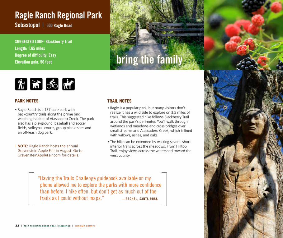
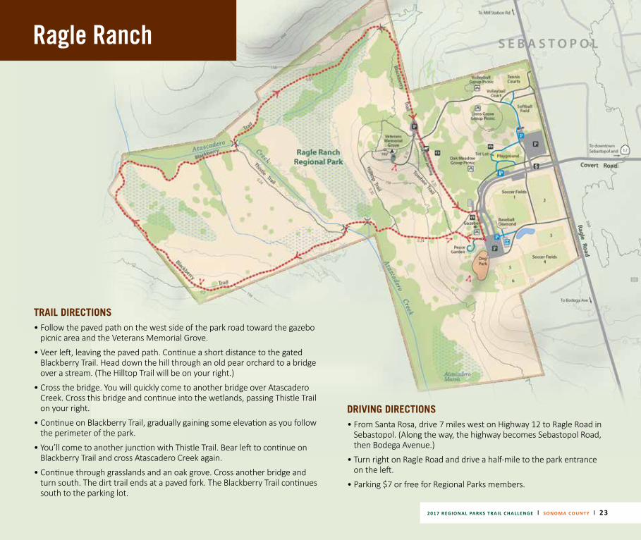
Ragle Ranch Regional ParkSebastopol | 500 Ragle Road
SUGGESTED LOOP: Blackberry TrailLength: 1.65 milesDegree of difficulty: Easy Elevation gain: 50 feet
PARK NOTES
• Ragle Ranch is a 157-acre park with backcountry trails along the prime bird watching habitat of Atascadero Creek. The park also has a playground, baseball and soccer fields, volleyball courts, group picnic sites and an off-leash dog park.
NOTE: Ragle Ranch hosts the annual Gravenstein Apple Fair in August. Go to GravensteinAppleFair.com for details.
“ Having the Trails Challenge guidebook available on my phone allowed me to explore the parks with more confidence than before. I hike often, but don’t get as much out of the trails as I could without maps.” —RACHEL, SANTA ROSA
TRAIL NOTES• Ragle is a popular park, but many visitors don’t
realize it has a wild side to explore on 3.5 miles of trails. This suggested hike follows Blackberry Trail around the park’s perimeter. You’ll walk through wetlands and meadows and cross bridges over small streams and Atascadero Creek, which is lined with willows, ashes, and oaks.
• The hike can be extended by walking several short interior trails across the meadows. From Hilltop Trail, enjoy views across the watershed toward the west county.
bring the family
Ragle Ranch
TRAIL DIRECTIONS• Follow the paved path on the west side of the park road toward the gazebo
picnic area and the Veterans Memorial Grove.
• Veer left, leaving the paved path. Continue a short distance to the gated Blackberry Trail. Head down the hill through an old pear orchard to a bridge over a stream. (The Hilltop Trail will be on your right.)
• Cross the bridge. You will quickly come to another bridge over Atascadero Creek. Cross this bridge and continue into the wetlands, passing Thistle Trail on your right.
• Continue on Blackberry Trail, gradually gaining some elevation as you follow the perimeter of the park.
• You’ll come to another junction with Thistle Trail. Bear left to continue on Blackberry Trail and cross Atascadero Creek again.
• Continue through grasslands and an oak grove. Cross another bridge and turn south. The dirt trail ends at a paved fork. The Blackberry Trail continues south to the parking lot.
DRIVING DIRECTIONS • From Santa Rosa, drive 7 miles west on Highway 12 to Ragle Road in
Sebastopol. (Along the way, the highway becomes Sebastopol Road, then Bodega Avenue.)
• Turn right on Ragle Road and drive a half-mile to the park entrance on the left.
• Parking $7 or free for Regional Parks members.
2017 REGIONAL PARKS TRAIL CHALLENGE | SONOMA COUNTY | 23

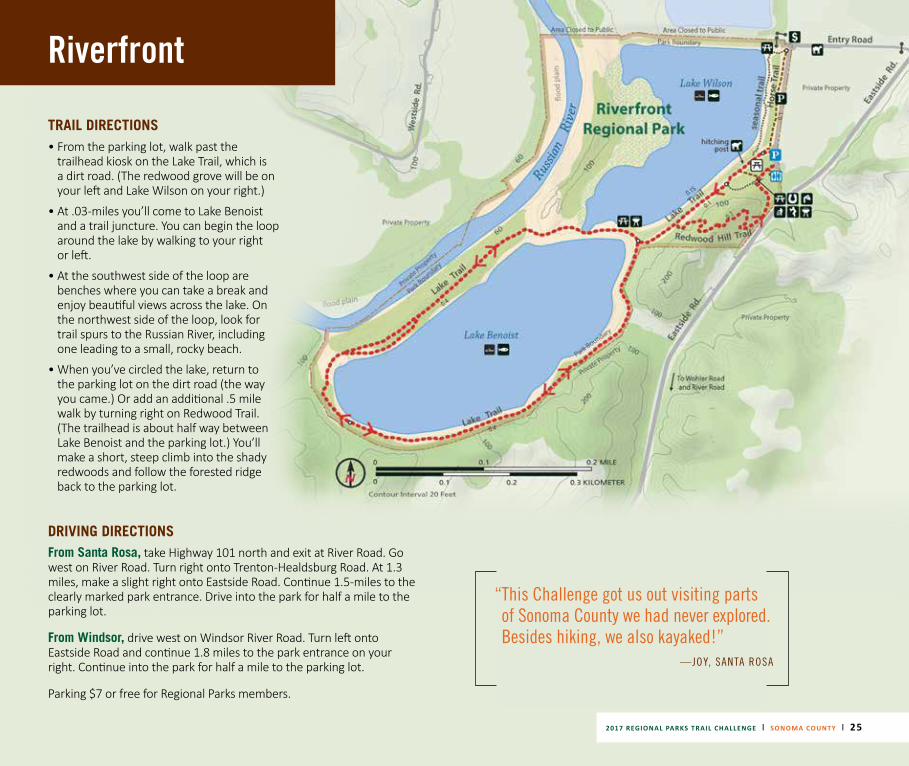
Riverfront Regional ParkWindsor | 7821 Eastside Road
SUGGESTED LOOP:
Lake Benoist Trail Loop to Redwood Hill Trail
Hike length: 2.18 miles or 2.68 miles
Degree of difficulty: Easy
Elevation gain: Flat
PARK NOTES• This 300-acre park is next to the Russian River, just minutes from downtown Windsor and
surrounded by classic Wine Country scenery. The park is a former quarry with mining areas transformed into beautiful lakes for fishing and kayaking.
• The park includes 1 mile of Russian River frontage, though the view of the river from the main trail is screened by foliage.
• A 15-acre grove of redwoods next to the parking area includes a half-mile trail, a group picnic area, a volleyball court, and restrooms and a drinking fountain.
TRAIL NOTES• The Lake Trail is a 2.18-mile loop passing Lake Wilson and circling Lake Benoist. It’s a wide,
mostly flat, unpaved trail ringed by redwoods, willows and cottonwoods.
• The river can be reached via trail spurs on the north side of the Lake Trail.
• The park is a rookery for great blue herons, North America’s largest heron, and nests can be spotted high in the trees from January-July. You may also see egrets and green herons.
24 | 2017 REGIONAL PARKS TRAIL CHALLENGE | SONOMA COUNTY
tranquil
2017 REGIONAL PARKS TRAIL CHALLENGE | SONOMA COUNTY | 25
Riverfront
TRAIL DIRECTIONS• From the parking lot, walk past the
trailhead kiosk on the Lake Trail, which is a dirt road. (The redwood grove will be on your left and Lake Wilson on your right.)
• At .03-miles you’ll come to Lake Benoist and a trail juncture. You can begin the loop around the lake by walking to your right or left.
• At the southwest side of the loop are benches where you can take a break and enjoy beautiful views across the lake. On the northwest side of the loop, look for trail spurs to the Russian River, including one leading to a small, rocky beach.
• When you’ve circled the lake, return to the parking lot on the dirt road (the way you came.) Or add an additional .5 mile walk by turning right on Redwood Trail. (The trailhead is about half way between Lake Benoist and the parking lot.) You’ll make a short, steep climb into the shady redwoods and follow the forested ridge back to the parking lot.
DRIVING DIRECTIONS From Santa Rosa, take Highway 101 north and exit at River Road. Go west on River Road. Turn right onto Trenton-Healdsburg Road. At 1.3 miles, make a slight right onto Eastside Road. Continue 1.5-miles to the clearly marked park entrance. Drive into the park for half a mile to the parking lot.
From Windsor, drive west on Windsor River Road. Turn left onto Eastside Road and continue 1.8 miles to the park entrance on your right. Continue into the park for half a mile to the parking lot.
Parking $7 or free for Regional Parks members.
“ This Challenge got us out visiting parts of Sonoma County we had never explored. Besides hiking, we also kayaked!”
—JOY, SANTA ROSA
26 | 2017 REGIONAL PARKS TRAIL CHALLENGE | SONOMA COUNTY
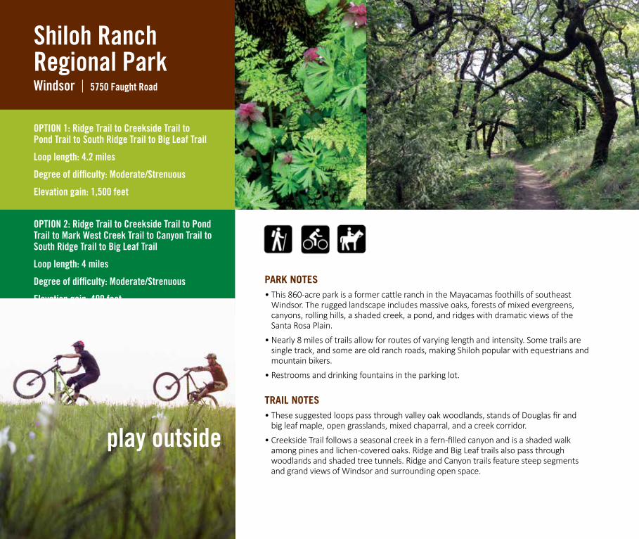
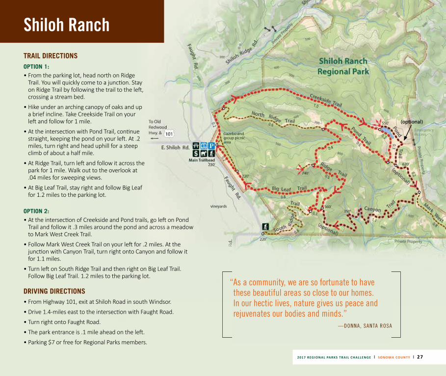
Shiloh Ranch
| Regional ParkWindsor 5750 Faught Road
OPTION 1: Ridge Trail to Creekside Trail to Pond Trail to South Ridge Trail to Big Leaf Trail
Loop length: 4.2 miles
Degree of difficulty: Moderate/Strenuous
Elevation gain: 1,500 feet
OPTION 2: Ridge Trail to Creekside Trail to Pond Trail to Mark West Creek Trail to Canyon Trail to South Ridge Trail to Big Leaf Trail
Loop length: 4 miles
Degree of difficulty: Moderate/Strenuous
Elevation gain: 400 feet
PARK NOTES• This 860-acre park is a former cattle ranch in the Mayacamas foothills of southeast
Windsor. The rugged landscape includes massive oaks, forests of mixed evergreens, canyons, rolling hills, a shaded creek, a pond, and ridges with dramatic views of the Santa Rosa Plain.
• Nearly 8 miles of trails allow for routes of varying length and intensity. Some trails are single track, and some are old ranch roads, making Shiloh popular with equestrians and mountain bikers.
• Restrooms and drinking fountains in the parking lot.
TRAIL NOTES• These suggested loops pass through valley oak woodlands, stands of Douglas fir and
big leaf maple, open grasslands, mixed chaparral, and a creek corridor.
• Creekside Trail follows a seasonal creek in a fern-filled canyon and is a shaded walk among pines and lichen-covered oaks. Ridge and Big Leaf trails also pass through woodlands and shaded tree tunnels. Ridge and Canyon trails feature steep segments and grand views of Windsor and surrounding open space.
play outside
2017 REGIONAL PARKS TRAIL CHALLENGE | SONOMA COUNTY | 27
Shiloh RanchTRAIL DIRECTIONSOPTION 1: • From the parking lot, head north on Ridge
Trail. You will quickly come to a junction. Stay on Ridge Trail by following the trail to the left, crossing a stream bed.
• Hike under an arching canopy of oaks and up a brief incline. Take Creekside Trail on your left and follow for 1 mile.
• At the intersection with Pond Trail, continue straight, keeping the pond on your left. At .2 miles, turn right and head uphill for a steep climb of about a half mile.
• At Ridge Trail, turn left and follow it across the park for 1 mile. Walk out to the overlook at .04 miles for sweeping views.
• At Big Leaf Trail, stay right and follow Big Leaf for 1.2 miles to the parking lot.
DRIVING DIRECTIONS • From Highway 101, exit at Shiloh Road in south Windsor.
• Drive 1.4-miles east to the intersection with Faught Road.
• Turn right onto Faught Road.
• The park entrance is .1 mile ahead on the left.
• Parking $7 or free for Regional Parks members.
“ As a community, we are so fortunate to have these beautiful areas so close to our homes. In our hectic lives, nature gives us peace and rejuvenates our bodies and minds.”
—DONNA, SANTA ROSA
OPTION 2:• At the intersection of Creekside and Pond trails, go left on Pond
Trail and follow it .3 miles around the pond and across a meadow to Mark West Creek Trail.
• Follow Mark West Creek Trail on your left for .2 miles. At the junction with Canyon Trail, turn right onto Canyon and follow it for 1.1 miles.
• Turn left on South Ridge Trail and then right on Big Leaf Trail. Follow Big Leaf Trail. 1.2 miles to the parking lot.
(optional)
Shorttail Gulch &
Pinnacle GulchCoastal Access Trails Bodega Bay | 20600 Mockingbird Drive
SUGGESTED TRAIL:
Either trail to beach and back or hike both trails as a loop during low tides
Length: 1.10 to 2.39 miles round trip
Degree of difficulty: Moderate
Elevation gain: 350 feet (on the return)
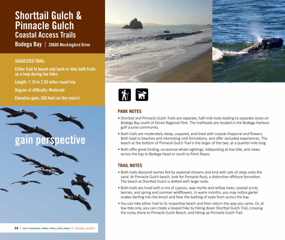
PARK NOTES• Shorttail and Pinnacle Gulch Trails are separate, half-mile trails leading to separate coves on
Bodega Bay south of Doran Regional Park. The trailheads are located in the Bodega Harbour golf course community.
• Both trails are moderately steep, unpaved, and lined with coastal chaparral and flowers. Both lead to beaches and interesting rock formations, and offer secluded experiences. The beach at the bottom of Pinnacle Gulch Trail is the larger of the two, at a quarter-mile long.
• Both offer great birding, occasional whale sightings, tidepooling at low tide, and views across the bay to Bodega Head or south to Point Reyes.
TRAIL NOTES• Both trails descend ravines fed by seasonal streams and end with sets of steps onto the
sand. At Pinnacle Gulch beach, look for Pinnacle Rock, a distinctive offshore formation. The beach at Shorttail Gulch is dotted with large rocks.
• Both trails are lined with a mix of cypress, wax myrtle and willow trees, coastal scrub, berries, and spring and summer wildflowers. In warm months, you may notice garter snakes darting into the brush and hear the barking of seals from across the bay.
• You can hike either trail to its respective beach and then return the way you came. Or, at low tide only, you can create a looped hike by hiking down Shorttail Gulch Trail, crossing the rocky shore to Pinnacle Gulch Beach, and hiking up Pinnacle Gulch Trail.
28 | 2017 REGIONAL PARKS TRAIL CHALLENGE | SONOMA COUNTY
gain perspective
2017 REGIONAL PARKS TRAIL CHALLENGE | SONOMA COUNTY | 29 2017 REGIONAL PARKS TRAIL CHALLENGE | | SONOMA COUNTY 29
Shorttail Gulch & Pinnacle Gulch
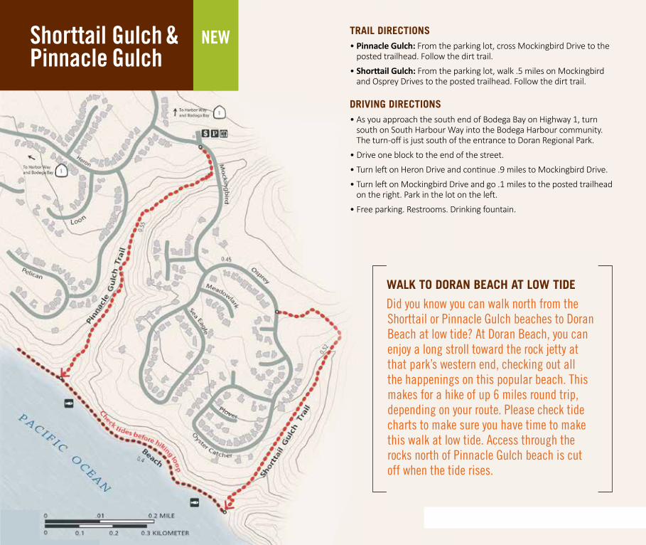
NEW TRAIL DIRECTIONS• Pinnacle Gulch: From the parking lot, cross Mockingbird Drive to the
posted trailhead. Follow the dirt trail.
• Shorttail Gulch: From the parking lot, walk .5 miles on Mockingbird and Osprey Drives to the posted trailhead. Follow the dirt trail.
DRIVING DIRECTIONS • As you approach the south end of Bodega Bay on Highway 1, turn
south on South Harbour Way into the Bodega Harbour community. The turn-off is just south of the entrance to Doran Regional Park.
• Drive one block to the end of the street.
• Turn left on Heron Drive and continue .9 miles to Mockingbird Drive.
• Turn left on Mockingbird Drive and go .1 miles to the posted trailhead on the right. Park in the lot on the left.
• Free parking. Restrooms. Drinking fountain.
WALK TO DORAN BEACH AT LOW TIDE
Did you know you can walk north from the Shorttail or Pinnacle Gulch beaches to Doran Beach at low tide? At Doran Beach, you can enjoy a long stroll toward the rock jetty at that park’s western end, checking out all the happenings on this popular beach. This makes for a hike of up 6 miles round trip, depending on your route. Please check tide charts to make sure you have time to make this walk at low tide. Access through the rocks north of Pinnacle Gulch beach is cut off when the tide rises.
Spring Lake
| Regional ParkSanta Rosa 393 Violetti Road
OPTION 1: Paved path around lakeDistance: 2.3 miles Degree of difficulty: Easy Elevation gain: 54 feet
OPTION 2: Paved and unpaved paths around lake Distance: 2.57 milesDegree of difficulty: EasyElevation gain: 54 feet
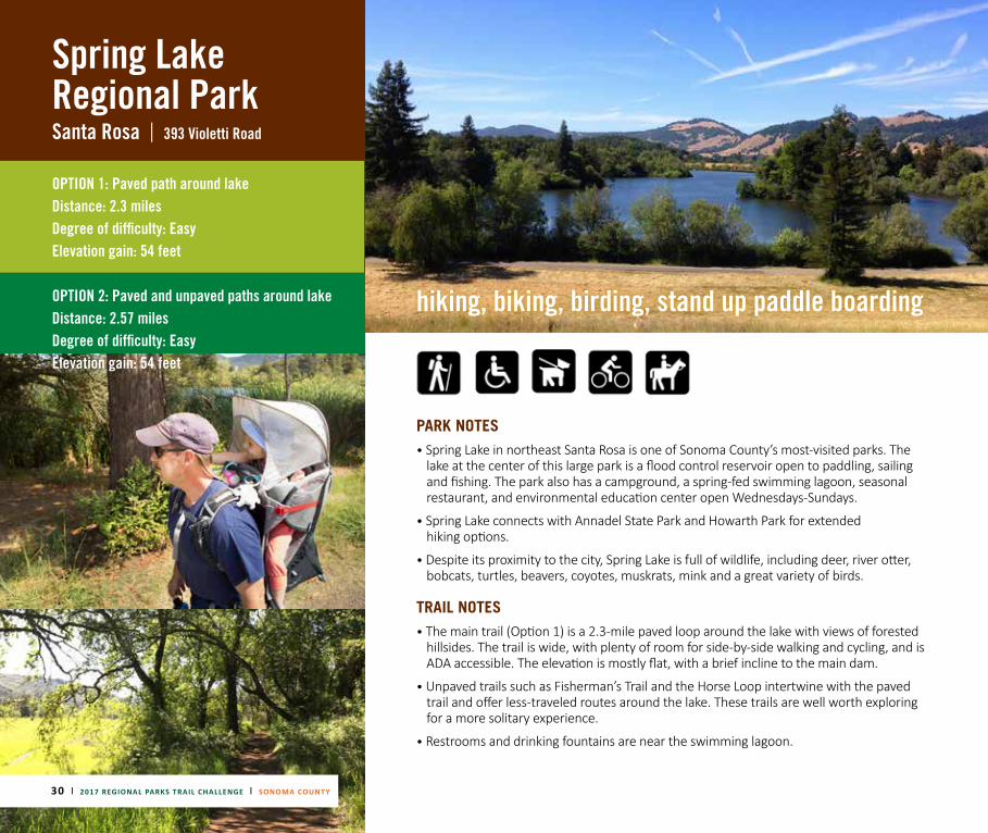
PARK NOTES• Spring Lake in northeast Santa Rosa is one of Sonoma County’s most-visited parks. The
lake at the center of this large park is a flood control reservoir open to paddling, sailing and fishing. The park also has a campground, a spring-fed swimming lagoon, seasonal restaurant, and environmental education center open Wednesdays-Sundays.
• Spring Lake connects with Annadel State Park and Howarth Park for extended hiking options.
• Despite its proximity to the city, Spring Lake is full of wildlife, including deer, river otter, bobcats, turtles, beavers, coyotes, muskrats, mink and a great variety of birds.
TRAIL NOTES• The main trail (Option 1) is a 2.3-mile paved loop around the lake with views of forested
hillsides. The trail is wide, with plenty of room for side-by-side walking and cycling, and is ADA accessible. The elevation is mostly flat, with a brief incline to the main dam.
• Unpaved trails such as Fisherman’s Trail and the Horse Loop intertwine with the paved trail and offer less-traveled routes around the lake. These trails are well worth exploring for a more solitary experience.
• Restrooms and drinking fountains are near the swimming lagoon.
30 | 2017 REGIONAL PARKS TRAIL CHALLENGE | SONOMA COUNTY
hiking, biking, birding, stand up paddle boarding
2017 REGIONAL PARKS TRAIL CHALLENGE | SONOMA COUNTY | 31
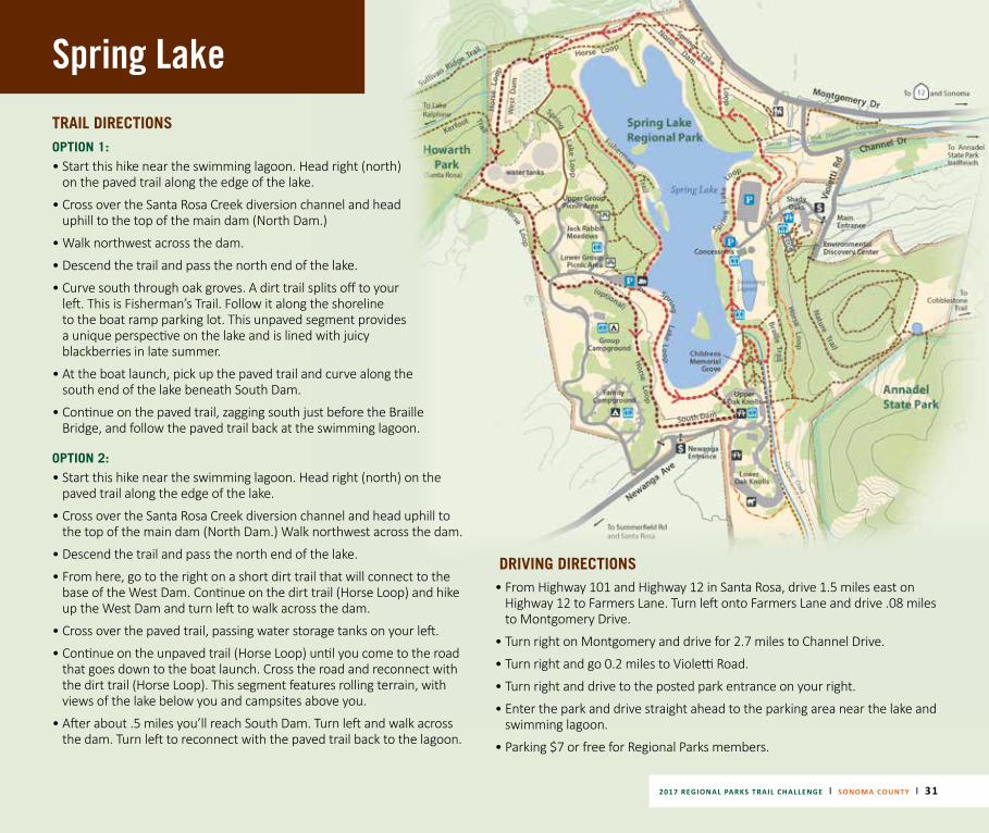
Spring LakeTRAIL DIRECTIONS OPTION 1:• Start this hike near the swimming lagoon. Head right (north)
on the paved trail along the edge of the lake.
• Cross over the Santa Rosa Creek diversion channel and head uphill to the top of the main dam (North Dam.)
• Walk northwest across the dam.
• Descend the trail and pass the north end of the lake.
• Curve south through oak groves. A dirt trail splits off to your left. This is Fisherman’s Trail. Follow it along the shoreline to the boat ramp parking lot. This unpaved segment provides a unique perspective on the lake and is lined with juicy blackberries in late summer.
• At the boat launch, pick up the paved trail and curve along the south end of the lake beneath South Dam.
• Continue on the paved trail, zagging south just before the Braille Bridge, and follow the paved trail back at the swimming lagoon.
OPTION 2:• Start this hike near the swimming lagoon. Head right (north) on the
paved trail along the edge of the lake.
• Cross over the Santa Rosa Creek diversion channel and head uphill to the top of the main dam (North Dam.) Walk northwest across the dam.
• Descend the trail and pass the north end of the lake.
• From here, go to the right on a short dirt trail that will connect to the base of the West Dam. Continue on the dirt trail (Horse Loop) and hike up the West Dam and turn left to walk across the dam.
• Cross over the paved trail, passing water storage tanks on your left.
• Continue on the unpaved trail (Horse Loop) until you come to the road that goes down to the boat launch. Cross the road and reconnect with the dirt trail (Horse Loop). This segment features rolling terrain, with views of the lake below you and campsites above you.
• After about .5 miles you’ll reach South Dam. Turn left and walk across the dam. Turn left to reconnect with the paved trail back to the lagoon.
DRIVING DIRECTIONS • From Highway 101 and Highway 12 in Santa Rosa, drive 1.5 miles east on
Highway 12 to Farmers Lane. Turn left onto Farmers Lane and drive .08 miles to Montgomery Drive.
• Turn right on Montgomery and drive for 2.7 miles to Channel Drive.
• Turn right and go 0.2 miles to Violetti Road.
• Turn right and drive to the posted park entrance on your right.
• Enter the park and drive straight ahead to the parking area near the lake and swimming lagoon.
• Parking $7 or free for Regional Parks members.
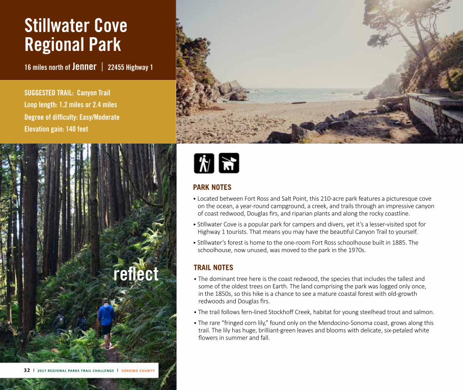
Stillwater Cove Regional Park16 miles north of Jenner | 22455 Highway 1
SUGGESTED TRAIL: Canyon Trail
Loop length: 1.2 miles or 2.4 miles
Degree of difficulty: Easy/Moderate
Elevation gain: 140 feet
PARK NOTES• Located between Fort Ross and Salt Point, this 210-acre park features a picturesque cove
on the ocean, a year-round campground, a creek, and trails through an impressive canyon of coast redwood, Douglas firs, and riparian plants and along the rocky coastline.
• Stillwater Cove is a popular park for campers and divers, yet it’s a lesser-visited spot for Highway 1 tourists. That means you may have the beautiful Canyon Trail to yourself.
• Stillwater’s forest is home to the one-room Fort Ross schoolhouse built in 1885. The schoolhouse, now unused, was moved to the park in the 1970s.
TRAIL NOTES• The dominant tree here is the coast redwood, the species that includes the tallest and
some of the oldest trees on Earth. The land comprising the park was logged only once, in the 1850s, so this hike is a chance to see a mature coastal forest with old-growth redwoods and Douglas firs.
• The trail follows fern-lined Stockhoff Creek, habitat for young steelhead trout and salmon.
• The rare “fringed corn lily,” found only on the Mendocino-Sonoma coast, grows along this trail. The lily has huge, brilliant-green leaves and blooms with delicate, six-petaled white flowers in summer and fall.
32 | 2017 REGIONAL PARKS TRAIL CHALLENGE | SONOMA COUNTY
reflect
Stillwater Cove
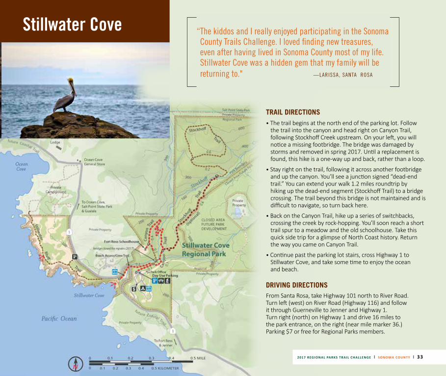
TRAIL DIRECTIONS• The trail begins at the north end of the parking lot. Follow
the trail into the canyon and head right on Canyon Trail, following Stockhoff Creek upstream. On your left, you will notice a missing footbridge. The bridge was damaged by storms and removed in spring 2017. Until a replacement is found, this hike is a one-way up and back, rather than a loop.
• Stay right on the trail, following it across another footbridge and up the canyon. You’ll see a junction signed “dead-end trail.” You can extend your walk 1.2 miles roundtrip by hiking up the dead-end segment (Stockhoff Trail) to a bridge crossing. The trail beyond this bridge is not maintained and is difficult to navigate, so turn back here.
• Back on the Canyon Trail, hike up a series of switchbacks, crossing the creek by rock-hopping. You’ll soon reach a short trail spur to a meadow and the old schoolhouse. Take this quick side trip for a glimpse of North Coast history. Return the way you came on Canyon Trail.
• Continue past the parking lot stairs, cross Highway 1 to Stillwater Cove, and take some time to enjoy the ocean and beach.
DRIVING DIRECTIONS From Santa Rosa, take Highway 101 north to River Road. Turn left (west) on River Road (Highway 116) and follow it through Guerneville to Jenner and Highway 1. Turn right (north) on Highway 1 and drive 16 miles to the park entrance, on the right (near mile marker 36.) Parking $7 or free for Regional Parks members.
“ The kiddos and I really enjoyed participating in the Sonoma County Trails Challenge. I loved finding new treasures, even after having lived in Sonoma County most of my life. Stillwater Cove was a hidden gem that my family will be returning to." —LARISSA, SANTA ROSA
2017 REGIONAL PARKS TRAIL CHALLENGE | SONOMA COUNTY | 33
34 | 2017 REGIONAL PARKS TRAIL CHALLENGE | SONOMA COUNTY
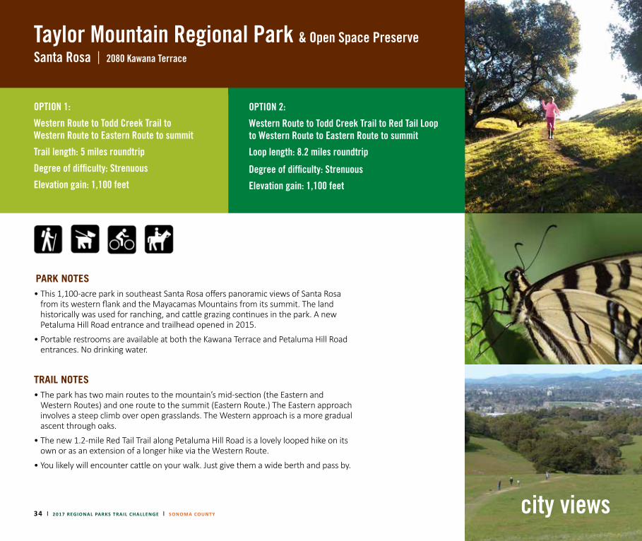
Taylor Mountain Regional Park |
& Open Space PreserveSanta Rosa 2080 Kawana Terrace
OPTION 1:
Western Route to Todd Creek Trail to Western Route to Eastern Route to summit
Trail length: 5 miles roundtrip
Degree of difficulty: Strenuous
Elevation gain: 1,100 feet
OPTION 2:
Western Route to Todd Creek Trail to Red Tail Loop to Western Route to Eastern Route to summit
Loop length: 8.2 miles roundtrip
Degree of difficulty: Strenuous
Elevation gain: 1,100 feet
PARK NOTES• This 1,100-acre park in southeast Santa Rosa offers panoramic views of Santa Rosa
from its western flank and the Mayacamas Mountains from its summit. The land historically was used for ranching, and cattle grazing continues in the park. A new Petaluma Hill Road entrance and trailhead opened in 2015.
• Portable restrooms are available at both the Kawana Terrace and Petaluma Hill Road entrances. No drinking water.
TRAIL NOTES• The park has two main routes to the mountain’s mid-section (the Eastern and
Western Routes) and one route to the summit (Eastern Route.) The Eastern approach involves a steep climb over open grasslands. The Western approach is a more gradual ascent through oaks.
• The new 1.2-mile Red Tail Trail along Petaluma Hill Road is a lovely looped hike on its own or as an extension of a longer hike via the Western Route.
• You likely will encounter cattle on your walk. Just give them a wide berth and pass by.
city views
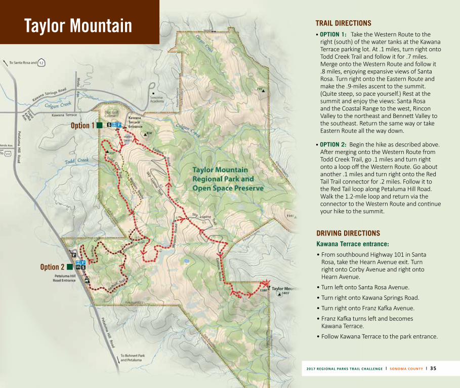
Taylor Mountain TRAIL DIRECTIONS• OPTION 1:
Take the Western Route to the right (south) of the water tanks at the Kawana Terrace parking lot. At .1 miles, turn right onto Todd Creek Trail and follow it for .7 miles. Merge onto the Western Route and follow it .8 miles, enjoying expansive views of Santa Rosa. Turn right onto the Eastern Route and make the .9-miles ascent to the summit. (Quite steep, so pace yourself.) Rest at the summit and enjoy the views: Santa Rosa and the Coastal Range to the west, Rincon Valley to the northeast and Bennett Valley to the southeast. Return the same way or take Eastern Route all the way down.
• OPTION 2: Begin the hike as described above. After merging onto the Western Route from Todd Creek Trail, go .1 miles and turn right onto a loop off the Western Route. Go about another .1 miles and turn right onto the Red Tail Trail connector for .2 miles. Follow it to the Red Tail loop along Petaluma Hill Road. Walk the 1.2-mile loop and return via the connector to the Western Route and continue your hike to the summit.
DRIVING DIRECTIONS Kawana Terrace entrance:
• From southbound Highway 101 in Santa Rosa, take the Hearn Avenue exit. Turn right onto Corby Avenue and right onto Hearn Avenue.
• Turn left onto Santa Rosa Avenue.
• Turn right onto Kawana Springs Road.
• Turn right onto Franz Kafka Avenue.
• Franz Kafka turns left and becomes Kawana Terrace.
• Follow Kawana Terrace to the park entrance.
Option 1
Option 2
2017 REGIONAL PARKS TRAIL CHALLENGE | SONOMA COUNTY | 35
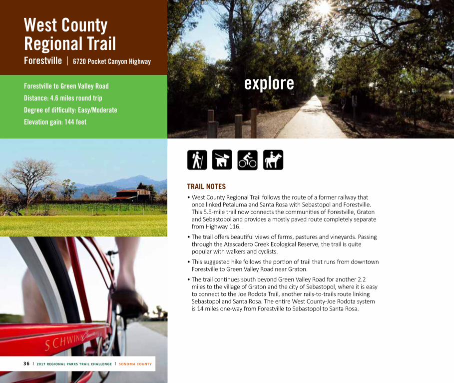
West County Regional TrailForestville | 6720 Pocket Canyon Highway
Forestville to Green Valley Road
Distance: 4.6 miles round trip
Degree of difficulty: Easy/Moderate
Elevation gain: 144 feet
TRAIL NOTES• West County Regional Trail follows the route of a former railway that
once linked Petaluma and Santa Rosa with Sebastopol and Forestville. This 5.5-mile trail now connects the communities of Forestville, Graton and Sebastopol and provides a mostly paved route completely separate from Highway 116.
• The trail offers beautiful views of farms, pastures and vineyards. Passing through the Atascadero Creek Ecological Reserve, the trail is quite popular with walkers and cyclists.
• This suggested hike follows the portion of trail that runs from downtown Forestville to Green Valley Road near Graton.
• The trail continues south beyond Green Valley Road for another 2.2 miles to the village of Graton and the city of Sebastopol, where it is easy to connect to the Joe Rodota Trail, another rails-to-trails route linking Sebastopol and Santa Rosa. The entire West County-Joe Rodota system is 14 miles one-way from Forestville to Sebastopol to Santa Rosa.
explore
36 | 2017 REGIONAL PARKS TRAIL CHALLENGE | SONOMA COUNTY
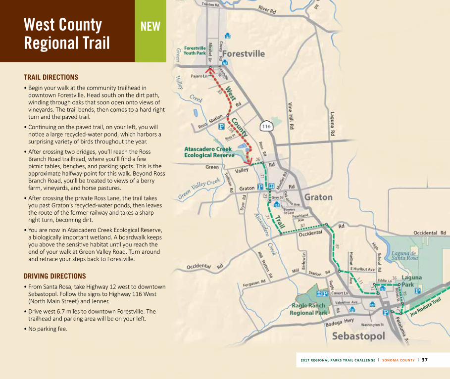
West County Regional Trail
2017 REGIONAL PARKS TRAIL CHALLENGE | SONOMA COUNTY | 37
NEW
TRAIL DIRECTIONS• Begin your walk at the community trailhead in
downtown Forestville. Head south on the dirt path, winding through oaks that soon open onto views of vineyards. The trail bends, then comes to a hard right turn and the paved trail.
• Continuing on the paved trail, on your left, you will notice a large recycled-water pond, which harbors a surprising variety of birds throughout the year.
• After crossing two bridges, you’ll reach the Ross Branch Road trailhead, where you’ll find a few picnic tables, benches, and parking spots. This is the approximate halfway-point for this walk. Beyond Ross Branch Road, you’ll be treated to views of a berry farm, vineyards, and horse pastures.
• After crossing the private Ross Lane, the trail takes you past Graton’s recycled-water ponds, then leaves the route of the former railway and takes a sharp right turn, becoming dirt.
• You are now in Atascadero Creek Ecological Reserve, a biologically important wetland. A boardwalk keeps you above the sensitive habitat until you reach the end of your walk at Green Valley Road. Turn around and retrace your steps back to Forestville.
DRIVING DIRECTIONS • From Santa Rosa, take Highway 12 west to downtown
Sebastopol. Follow the signs to Highway 116 West (North Main Street) and Jenner.
• Drive west 6.7 miles to downtown Forestville. The trailhead and parking area will be on your left.
• No parking fee.
Joe Rodota Trail
38 | 2017 REGIONAL PARKS TRAIL CHALLENGE | SONOMA COUNTY
THANK YOU TO OUR SPONSORS FOR THEIR GENEROUS SUPPORT OF THE 2017 SONOMA COUNTY PARKS TRAILS CHALLENGE!
2017 REGIONAL PARKS TRAIL CHALLENGE | SONOMA COUNTY | 39
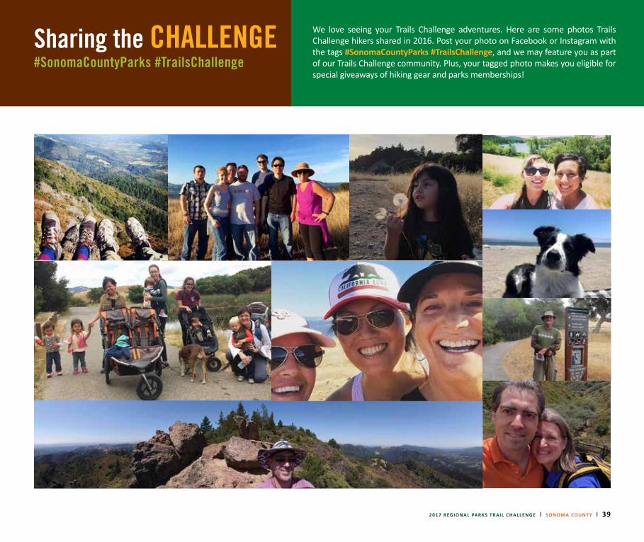
Sharing the CHALLENGE#SonomaCountyParks #TrailsChallenge
We love seeing your Trails Challenge adventures. Here are some photos Trails Challenge hikers shared in 2016. Post your photo on Facebook or Instagram with the tags #SonomaCountyParks #TrailsChallenge, and we may feature you as part of our Trails Challenge community. Plus, your tagged photo makes you eligible for special giveaways of hiking gear and parks memberships!

40 | 2017 REGIONAL PARKS TRAIL CHALLENGE | SONOMA COUNTY
JOIN NOW!B E C O M E A M E M B E R !
Become a Regional Parks Member and pay once to park all year at any of your
Sonoma County parks! + Free night of camping + Festival admission
Thank you to photographers Edward Kent, Tom Reynolds, Charlie Gesell, Dan Quinones,
Mark Winterlin, Lorenzo Paran, and our social media community for sharing your
beautiful images. Thank you to author Robert Stone for information from "Day Hikes
Around Sonoma County," to writer Brian Michelsen for trail recommendations and
descriptions, and to Ben Pease for the park maps.
Post your photos with #SonomaCountyParks #TrailsChallenge. sonomacountyparks.org