table of contents - boise · pdf filetable of contents . ... plan application.2 stakeholder...
TRANSCRIPT
i
Table of Contents Introduction ................................................................................................................................................. 1
Background ................................................................................................................................................. 3
Consistency with Blueprint Boise ............................................................................................................. 5
The Planning & Zoning Commission Recommendation ......................................................................... 9
Staff Recommendation ............................................................................................................................. 10
Mitigation of Jefferson Closure and Conformance with Blueprint Boise ........................................... 13
The Way Forward/Conclusion.................................................................................................................. 22
Frequently Asked Questions ................................................................................................................... 24
Appendices Appendix A St. Luke’s External Meetings and Presentations Appendix B North, South, East and West Alternatives Analysis Appendix C Bannock Corridor Design Workshop Technical Memo Appendix D Multimodal Transportation System Renderings Appendix E St. Luke’s Letter to Ada County
SUPPLEMENTAL NARRATIVE - 1 3/30/15
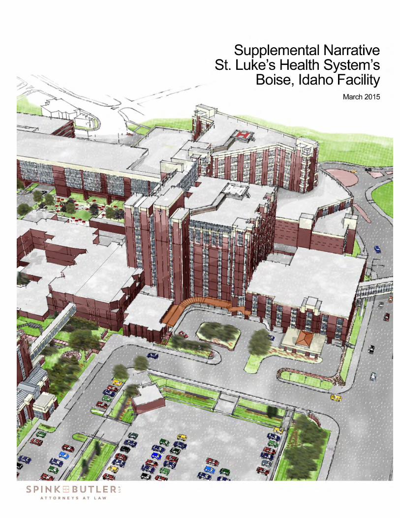
Introduction St. Luke’s Health System’s (“St Luke’s”) application to Boise City (“Boise” or the “City”) was made in October, 2014 requesting that the City adopt the Master Plan for St. Luke’s Boise, Idaho Facility (“Master Plan”) as consistent with and under the umbrella of Blueprint Boise (“Blueprint Boise”) Prior to application, St. Luke’s and its team of consultants1 met periodically with the City’s Planning and Development Services Staff (“Staff”) for its professional guidance on how best to prepare the application. Blueprint Boise was consulted throughout the preparation of the Master Plan application.2 Stakeholder and neighborhood engagement began in October 2013, a full year prior to submitting the application to the City, and input was integrated with and considered in the development of the Master Plan. To be sure, master planning for health care in the 21st century is a complicated task, made more so in an urban, infill setting. Where many major hospitals have multiples of tens of acres to work with, St. Luke’s Boise facility has about half that. Yet, Blueprint Boise encourages more compact patterns of growth, and reminds us that responsible growth is taking advantage of the opportunities for infill and redevelopment in established parts of the City.3 Through this proposed Master Plan, St. Luke’s intends to guide its continuing 100+ year tradition to improve the health care for our community, and to implement other Blueprint Boise themes such as improving connectivity, and improving the economy of the community.4 Approval of the application is a choice for access to greater health care and a choice for access to enhanced and safer public connectivity. Implementing all the themes of Blueprint Boise’s
1 In addition to St. Luke’s in-house architects, engineers and attorneys, professional consulting was provided by: Architectural Nexus; CH2M Hill; Engineering Incorporated; Hummel Architects, PA; Platform Architecture Design; South Landscape Architecture; Spink Butler, LLP; Squyres Strategic Communications; The Land Group; Walker Parking Consultants; Wipfli CPAs & Consultants; and ZGF Architects LLP.
2 Additionally, since the Citywide vision of Blueprint Boise calls for an increasingly “connected
community” that includes the physical connections of multimodal transportation, the staff at Ada County Highway District (“ACHD”) provided its pre-application guidance in the preparation of the appropriate transportation studies.
3 See, Blueprint Boise, Chapter 2: Citywide Policies. The City, and especially particular City leaders long
associated with advocating Smart Growth principles, through Blueprint Boise, promotes an integrated approach to land use and transportation planning. The City’s commitment to this integration is paramount to the success of Blueprint Boise. See, Blueprint Boise, Page 2-46.
Blueprint Boise goals and policies that inspire the Master Plan include: Goal CC1: Minimize the impact of transportation systems on climate change; Policy CC1.1: Reduce vehicle miles traveled (VMT): (a): Encourage infill development in order to avoid costly extensions of transportation facilities and to minimize travel distances; Policy CC1.2: Transportation Investments: The City’s top priority for investment of federal and local transportation dollars is to maintain the roadway, transit, and pedestrian/bicycle system [and e]xpand the capacity of the transit system and the bicycle and pedestrian facilities. All improvements to the roadway system will be designed to accommodate all modes.
4 Additionally, the adoption of the Master Plan implements the major theme of Blueprint Boise to improve
the predictability of development for St. Luke’s and the community. The Master Plan, if adopted, sets the blueprint for development of the St. Luke’s campus. See, Blueprint Boise, Pages 2-23 – 2-32.
SUPPLEMENTAL NARRATIVE - 2 3/30/15
plan for our mutual future improves our collective Quality of Life – a grand goal, to be sure – a goal that we can feel closer to achieving when we find we are all equitably sharing the benefits and burdens of our increasingly urban lives.5 The Master Plan represents St. Luke’s blueprint for the coming years. The design and engineering of the buildings and the transportation system are, of course, not finished with the adoption of the Master Plan. The built environment will go through both informal and formal public processes before final approvals. We look forward to our continuing partnership with the City, ACHD and our neighbors to share and include our visions for our community and the St. Luke’s campus. This Supplemental Narrative summarizes the Master Plan’s compliance with Blueprint Boise and also addresses the many questions and comments received by both St. Luke’s and the City. Combined with the record as a whole, the City Council has at its disposal the factual information to support its legal conclusion that the Master Plan:
(a) Is required for the public convenience or necessity, or for the general welfare of the community;
(b) Is necessary to address changes in conditions within the community that have
occurred since the Boise City Comprehensive Plan was adopted or is necessary to correct one or more goal, objective, or policy that exist in the plan;
(c) Is in compliance with and will further the goals, objectives, and policies of the
Boise City Comprehensive Plan;
(d) Will not create inconsistencies between the goals, objectives, and policies within or between any chapter of the Boise City Comprehensive Plan; and
(e) Will not place an undue burden on transportation or other public facilities in any
planning area, and does not adversely impact the delivery of services by any political subdivision providing services.6
5 The effort to find this balance is the priority of Blueprint Boise to achieve a sustainable community. Blueprint Boise defines a sustainable community as one "where the economic, social, and environmental systems are in balance, so as to provide a healthy, productive, and meaningful life for its residents, without compromising the ability of future generations to meet their own needs." See, Blueprint Boise, Page B-9.
Further, Blueprint Boise directs its decision-makers to provide a balanced approach in considering applications by carefully considering all of the themes of the Comprehensive Plan. See, Blueprint Boise, Page 2-1.
6 Boise City Code, Section 11-03-04.16.B(7). Could the closure of a block of Jefferson put an undue
burden on transportation facilities? Yes. Will the closure of a block of Jefferson as proposed under the Master Plan put an undue burden on the transportation facilities? No.
To withstand scrutiny, a request for a change to the transportation facilities must provide offsetting mitigation that provides a legitimate public benefit to the traveling public. It is true that the traveling public would not have the connectivity provided by a block of Jefferson – a block designed with two lanes and parking on both sides. The facts presented with the application, including the transportation studies, and this Supplemental Narrative show that the connectivity the traveling public receives in return for the block closure ensures there is no undue burden on transportation facilities.
SUPPLEMENTAL NARRATIVE - 3 3/30/15
Background St. Luke’s mission and goal for its entire health system is the foundation on which St. Luke’s based the master planning process for its Boise facility:
Mission: To improve the health of people in our region. Goal: To build better health by delivering personalized, innovative, and exceptional care.
St. Luke’s is committed to serving Boise, as well as the broader region’s health care needs. Growth throughout our community is expected to increase by as much as 46 percent, or nearly 300,000 people, by 2030.7 An aging population, increases in obesity and chronic health conditions, population growth and the need to modernize and upgrade aging infrastructure all drive the need for St. Luke’s to transform its Boise hospital campus to continue to deliver innovative and exceptional care to patients for decades to come. St. Luke’s has proven to be a significant stimulus for the local economy. Based on an independent 2012 study by the University of Idaho the economic impact of St. Luke’s is positive in that every dollar spent by St. Luke’s or employee hired the local economy also grows. For example in 2012 the Boise facility employed approximately 5,600 employees and had operating expenses of approximately $675,000,000 which provided an estimated total economic benefit to the local economy in the amount of $1.4 billion in revenue, and an estimated 15,600 jobs to the area. 8 Since 2012 these numbers have increased. It is envisioned that increasing job opportunities in this distinctive area of Boise will increase opportunities for public transportation and non-motorized vehicle commuting opportunities as well as support the burgeoning Downtown Boise housing market. 9 The impact to the Boise economy would be significant.
7 John Church, Idaho Economics. 8 The Updated FY 2012 Economic Impacts of St. Luke’s Health System in Idaho With a Focus on the
Medical Centers of Boise, Meridian, Twin Falls, Ketchum, Jerome, and McCall Sponsored by St. Luke’s Health System; Steven Peterson, Clinical Assistant Professor, Economics, College of Business and Economics, University of Idaho, Moscow, Idaho, March 11, 2013.
9 The expansion of St. Luke’s Boise facility promotes the economic goals of Blueprint Boise that urge the
City to maintain its current economic position and identify opportunities that strengthen the economic base of the community. Blueprint Boise promotes continued focus on Downtown for economic development, which is recognized as a unique area of the community whose long-term health and viability are critical to the economic success of the community as a whole.
The economic development goals and policies of Blueprint Boise are centered on the principles to
maintain and enhance the City's diverse job base and to reinforce the role of Downtown as the City's employment center. See, Blueprint Boise, Page 2-69. See also, Blueprint Boise: Goal EC3: Protect the economic climate for existing businesses and promote opportunities for expansion; Policy EC3.4: Foster expansion of existing medical clusters: Work with existing medical facilities to ensure that their future space needs can be accommodated within adjacent established neighborhoods; Goal DT-ED1: Create and maintain a prosperous economy in Downtown; Goal DT-ED2: Strive to keep Downtown’s economy diversified; and Goal DT-ED 3: Find an appropriate balance between the demands for economic prosperity, historic preservation, and quality design in reviewing development applications. The policies in connection with these Blueprint Boise Goals all speak to the need to balance all of these issues during the development review process. See, Blueprint Boise, Page DT-23, Policies DT-ED3.1, DT-ED3-2 and DT-ED3.3.
SUPPLEMENTAL NARRATIVE - 4 3/30/15
Just as Blueprint Boise strives for balance to achieve sustainability, the theme of the Master Plan is the balance of specialized hospital and health care planning with land use planning that integrates the surrounding community, especially through expanded, safer multimodal connectivity. St. Luke’s, recognizing the special – and spatial – context within which its health care facility resides, engaged a wide range of professionals to develop its Master Plan. Their task was to meet the hospital’s needs and expand public infrastructure – especially bicycle and pedestrian facilities – in and around the Near East End where St. Luke’s campus resides. The Boise community’s consensus, outlined in Blueprint Boise, is that being a "connected community" includes multimodal transportation objectives and opportunities.10 Like the City as a whole, St. Luke's, strives for enhanced connection to provide safe and efficient facilities for pedestrians, bicyclists and motorists – all in an effort for long-term sustainability.11 That commitment is not mere lip service. St. Luke’s will always be a destination drawing many travelers. St. Luke’s is also located at a pivotal point where travelers will pass through on their way to Southeast Boise, Downtown, Fort Boise, the North End and beyond. St. Luke’s has worked diligently to ensure that its Master Plan is designed in every way to also support the City’s and St. Luke’s shared goals for a strong economy and employment base,
10 Blueprint Boise’s goals and policies that promote a physically connected community are founded on
principles of an integrated approach to land-use and transportation planning and an expansion of the City’s non–motorized transportation options. See, Blueprint Boise, Page 2-45.
11 St. Luke's Employee Transportation Alternatives (“ETA”) program was created to alleviate traffic and
parking congestion, and address air quality issues in the community. The program includes: St. Luke's contracts with ValleyRide so that an employee ID badge is the equivalent of a free bus
pass to anywhere in the ValleyRide system. Employees that join a Commuteride vanpool ride free for the first month and are subsidized for
the costs thereafter. Employees that carpool (i.e., two or more employees in one car) are eligible for a discounted
parking rate on campus. Participants in the ETA program are eligible for the Guaranteed Ride Home program, which
provides for free taxi service in the event of an emergency or schedule change. Employees who bike to work 60% of the time between May 1 and October 31 receive a $40
coupon to a participating bike shop. Secure bicycle parking is available as well as lockers and showers to encourage bicycling to
work. Employees who walk to work at least 60% of the year receive a $25 coupon to a participating
walking/running store.
St. Luke's is also one of the two title sponsors for Boise GreenBike (formerly Boise Bike Share), a division of Valley Regional Transit. One of the bike sharing station hubs will be located at Bannock Street and Avenue B on the St. Luke’s campus. See, Master Plan, Page 24.
Even before Blueprint Boise was adopted, St. Luke’s embodied the City’s goal to improve the efficiency of the transportation system by using Travel Demand Management (TDM). See Goal CC4 and Policy CC4.3: Employer Programs: (a) Support Commuteride's employer programs through referrals of new businesses. (b) Promote and give public recognition to participants involved in successful trip conversion programs sponsored by agencies and companies. (c) Rather than providing free employee parking, encourage employers to provide an employee transportation subsidy that can be applied toward the purchase of a transit pass, vanpool program, or a parking permit.
SUPPLEMENTAL NARRATIVE - 5 3/30/15
through a stable, safe, healthy, connected community.12 Design and engineering concepts of the Master Plan will be further refined through active engagement with the City, ACHD and various stakeholders before implementation. Consistency with Blueprint Boise Starting in 2009 and ending in October 2014 when St. Luke’s made its application to the City of Boise to include its Master Plan as part of Blueprint Boise, St. Luke’s evaluated its Boise campus and identified needed changes to the current facility to meet St. Luke’s health care objectives for the community. St. Luke’s professional team of consultants conducted extensive architectural, engineering and cost analyses during this five-year period to also identify the land planning objectives for St. Luke’s and the community at large. The result of that comprehensive analysis was an understanding of what the Master Plan application should contain. During the years St. Luke’s spent developing its Master Plan application, St. Luke’s met with hundreds of individuals, local government representatives, neighborhood associations and other stakeholders.13 Through these engagements, many questions were asked, concerns were raised, and suggestions shared. St. Luke’s endeavored to include those suggestions in the Master Plan. The questions and concerns – inevitable with a large and important proposal – reflect the expected tension between Blueprint Boise’s primary goal to address citywide planning policies within the more local context of the surrounding neighborhood. The Master Plan contains connectivity concepts that will continue to evolve as engineering and design details are finalized over the coming months and years. Details will become firm during the design review process at the City and also through continued ACHD and stakeholder meetings. St. Luke’s Downtown hospital development is consistent with the City’s desire to make Boise “the most livable city in the country” and, as described below, can assist the City in realizing its vision, not only for the St. Luke’s planning area, which straddles the Near East End and Downtown, but also the adjacent Military Reserve, Fort Boise and Veteran’s Administration areas (collectively, the “Fort Boise” area). St. Luke’s is eager to work in the future with the City and ACHD to improve the multimodal transportation system in the greater St. Luke’s/Fort Boise area. Still, in the immediate present, in putting together the Master Plan, St. Luke’s has been most keen to follow the goals and policies of Blueprint Boise as they relate to the interface between St. Luke’s and its East End neighbors. St. Luke’s, just like the East End Neighborhood Association (“EENA”), is aware of and sensitive to the fact that the City’s Downtown planning area has been steadily creeping closer to St. Luke’s and the Near East End. In 1988, when EENA published its East End Neighborhood Policy Guide (“EENPG”), it provided a “Background Report” with a brief history of the area since
12 See, Blueprint Boise, Pages 2-1 – 2-5. 13 See Appendix A for a partial list of the meetings held and open house presentations given. As a
member of the East End Neighborhood, and located in the Near East End, St. Luke’s engaged with its neighbors and neighborhood associations a full year before submitting its Master Plan application to the City, which may be unprecedented in the City. St. Luke’s listened to its neighbors and incorporated suggestions into the proposed Master Plan. Some of the comments, concerns, suggestions and their incorporation into the Master Plan are also listed in Appendix A.
SUPPLEMENTAL NARRATIVE - 6 3/30/15
the establishment of Fort Boise in 1863.14 The Background Report summarized the many changes to the East End Neighborhood over 150 years and concluded with this statement:
But just as vacant land is built upon, developed land is redeveloped and neighborhoods change once again. This is what is happening to the oldest sections of the East End that was part of the original plat of the Boise townsite. Downtown has moved into the near East End and with it have come plans for office conversions, government office towers and high-rise residences. The changes of the future promise to be as exciting, and sometimes as difficult to grow comfortable with, as the changes of the past. This plan contains the neighborhood’s ideas for change and preservation, and our vision for the neighborhood of the future.15
EENA’s historical discussion of St. Luke’s in the Near East End, written in the late 1980s, could have been written today:
St. Lukes [sic] Hospital provides important healthcare to the East End, Boise City and the Treasure Valley. St. Luke's expansion plans should, at a minimum, be consistent with the goals and recommendations of the neighborhood plan. Other issues that emerge during expansion should be resolved at periodic meetings of the hospital, the neighborhood and Boise City. Issues of concern include: displacement and relocation of residents, traffic circulation, parking, street closures, visual qualities, removal of historically significant structures and boundaries for expansion. 16
St. Luke’s efforts have been directed toward the design of a multimodal system that fulfills the goals and policies of Blueprint Boise, including the goals and policies for our East End neighborhood: For example:
Goal NE-C2: Ensure future roadway improvements enhance rather than detract from the North/East End character. Policy NE-C2.1: Street design: Ensure street improvements in the construction of new roadways occurs in compliance with citywide Street policies contained in Chapter 2 of this Comprehensive Plan.
Goal NE–C3: Facilitate the expansion of multi-modal facilities. Policy NE–C3.3: Sidewalks: Require sidewalks to be separated from roadway for the safety and comfort of pedestrians. Policy NE–CCN2.2: St. Luke's Regional Medical Center: Develop the St. Luke's Regional Medical Center area in accordance with the St. Luke's Campus Master Plan.
14 The EENPG was adopted by the City in 1988 and revised in 1999 to make the neighborhood plan
consistent with the 1997 Boise City Comprehensive Plan. The Background Report has been retained as an historical record. The Background Report, while providing a wealth of background information, is not an official part of the Neighborhood plan.
15 East End Neighborhood Policy Guide Background Report, Page 3-8. 16 EENPG, Background Report, Page 3-19.
SUPPLEMENTAL NARRATIVE - 7 3/30/15
Policy NE–CCN 2.3: Medical Office/Support Services: Permit private medical offices and support services between Avenues B and C and East Jefferson that are comparable to the bulk and scale of existing structures. Limit scale and bulk of new structures north of East Jefferson to scale and bulk comparable to the adjacent, existing residential neighborhood.
St. Luke’s, with its emphasis on providing state-of-the-art health care services and promoting the health and wellness of Boise citizens through active lifestyles, has, as Blueprint Boise points out, a symbiotic relationship with the East End Neighborhood, with its emphasis on active lifestyles, easy access to outdoor recreational opportunities and the general desire to live compactly to facilitate riding bikes or walking to work (often at St. Luke’s), shopping or schools.17 St. Luke’s has taken great attention – even pride – in designing multimodal transportation improvements that its nearest neighbors could, themselves, be proud to point out as a community benefit and an asset to the East End Neighborhood.18 So, without a doubt, it has been difficult for us, after so many outreach meetings and our continuing desire to engage in design give-and-take, to have representatives from EENA summarily tell the Commission that there has been a lack of community engagement by St. Luke’s; or there has been no serious exploration of opportunities to improve connectivity; or that, without explanation, we are just plain incompatible with Blueprint Boise. The one policy of Blueprint Boise that seems to capture the ire of some of our neighbors is a policy applicable to the Downtown planning area and, arguably, may not apply to St. Luke’s:
Policy DT-C 2.1: Block Pattern
(a) Retain a high level of connectivity in Downtown by maintaining the traditional street grid and block pattern (260 feet by 300 feet).
(b) Where superblocks exist, work with property owners and developers when redevelopment is proposed to re-establish the street grid and create blocks that approximate the traditional block size. If it is not feasible to re-establish streets, obtain public pedestrian ways protected by easements in place of the street grid so development areas approximate the traditional block size.
(c) Avoid development of megastructures on superblocks that create either real or perceived barriers to connectivity.
17 Policy DT-CCN1.6: Relationship To Nearby Neighborhoods (a) Recognize that Downtown and the traditional neighborhoods that encircle Downtown have a
symbiotic relationship. Monitor the health of Downtown and these neighborhoods, and invest in keeping these places prosperous.
(b) Recognize that the neighborhoods surrounding Downtown contribute to the workforce and customer base for Downtown businesses and provide a reservoir of housing for Downtown workers. Maintain close ties between Downtown and these neighborhoods through walking and bicycling routes, transit, range of available shopping, services, dining, culture and entertainment, and through community events.
18 The transportation engineers and designers are, in the main, avid cyclists (at all levels) with a keen
interest to help improve the City’s multimodal system. Kristen Armstrong, Olympic Gold Medal cyclist and St. Luke’s Community Health Ambassador, has shared her wealth of knowledge with the multimodal facilities designers. She has been happy to share her cycling knowledge, and St. Luke’s and the community are fortunate to have her expertise so close at hand.
SUPPLEMENTAL NARRATIVE - 8 3/30/15
St. Luke’s appreciates the concept of a grid system to efficiently and safely disperse traffic – after all, St. Luke’s employees and emergency vehicles must traverse the City’s streets to reach the facility. No doubt the Council, like the Commission before it, will have some individuals tell it that the singular issue involving closure of a block of Jefferson Street allowing St. Luke’s to build a large modern hospital is so completely contrary to Blueprint Boise that merely asking for the closure of a block of a public street calls for outright rejection of the Master Plan. However, there are competing goals to consider – the City’s desire for the provision of superior health care facilities for its citizens, and safe and efficient transportation of the City’s motorists, bicyclists and pedestrians. The City must not allow these goals to be mutually exclusive and must instead look to the particular circumstances, including the TIS and the proposed improvements to the public infrastructure, to determine whether connectivity is served by the change.19 The Council knows from its experience that there is perhaps never an application where the Council can find complete compliance with every single goal and policy of Blueprint Boise. Which is exactly why Blueprint Boise reminds the Council, as the decision-maker, that “a balanced approach to decision-making should be employed in the day-to-day application of this Comprehensive Plan.”20 Blueprint Boise continues: ”Careful consideration should be given to the extent to which each decision relates to one or more of the seven themes [of Blueprint Boise]. Generally, decisions should be supportive of the overall philosophy embodied in each theme.” We believe firmly that St. Luke’s Master Plan, inspired and guided by Blueprint Boise, supports the overall philosophy of the City.21
19 We do not agree with some neighbor’s characterization of the hospital expansion as a “superblock” or a “wall” in the neighborhood. Please refer to the “Frequently Asked Questions” section on page 25 where an artist’s rendering of the hospital at Avenue B and Jefferson is found. The rendering depicts the latest design, which will be refined and reviewed by the City’s Design Review Committee.
Parenthetically, a “superblock” is an urban planning technique developed in the 1920s and used through the mid -20th century to plan fairly large (population of 3 – 9,000 people and many blocks), mixed-use neighborhoods. See, e.g., Patricios, Urban Design Principles of the Original Neighborhood Concepts, J. of Urban Morphology, 6(1), 2002, pp. 21-32. Although developed to promote pedestrian activity and social interaction, they were often so large that, rather than walking for errands, car dependency became the norm. This is why the traditional “superblock” is often decried; however, this is not what is proposed by St. Luke’s. Even if one considered the hospital expansion a superblock, which it is not, today many urban planning professionals are re-looking at superblocks as a new model of urban mobility – provided there is the establishment of multimodal transportation. This is what is proposed by St. Luke’s.
20 Blueprint Boise, Page 2-1. 21 Throughout this Supplemental Narrative we have described how St. Luke’s supports the overall
philosophy embedded in each theme of Blueprint Boise except for the theme regarding culture, education, arts, and history. See Blueprint Boise, Page 2-58. In fact, St. Luke’s has been a major promoter of the goals and policies that support this major theme of Blueprint Boise.
Historically and culturally, St. Luke’s has been undergoing an extensive effort, along with various preservation organizations to preserve historically interesting structures in the vicinity of the hospital. This effort is described in more detail in the “Frequently Asked Questions” section of this Supplemental Narrative. Further, a major display featuring the over 100 years of St. Luke’s history in Boise will be open for public viewing. As Blueprint Boise notes on Page 2-58, educational facilities are a source of pride for residents. St. Luke’s is especially proud of the St. Luke’s Children’s School located within the Children’s Hospital. In 2014, 1,000 in-patient and out-patient students attended the K-12 Children’s School. Public Art is planned for the hospital expansion in locations such as the pocket park and parking garages.
SUPPLEMENTAL NARRATIVE - 9 3/30/15
The Planning & Zoning Commission Recommendation The Planning & Zoning Commission (“Commission”) expressed confusion about why the St. Luke’s application centered on the “North Alternative” rather than one of the three other alternatives referenced in the Master Plan for background information. To the extent that we confused the Commission by providing too much information on how we arrived at our starting point before reaching out to our neighbors and stakeholders, we apologize. It is only the North Alternative, and none of the other alternatives, that is the one application that St. Luke’s has made for a comprehensive plan amendment.22 At the end of five years of health care planning, it was clear that the North Alternative must be the basis of St. Luke’s Master Plan application. The planning analysis revealed that the North Alternative: (1) meets health care planning criteria; (2) maximizes St. Luke’s existing infrastructure investments; and (3) minimizes construction costs and time. This conclusion in no way detracts from the fact that the North Alternative must still be reviewed by the City to determine if the application provides a worthy amendment to Blueprint Boise from a land planning perspective. The Commission appeared to reach the conclusion that the application calls for a black and white choice between: (1) access to greater health care with a loss of access to a block of Jefferson; or (2) lesser health care with continued access to a block of Jefferson. However, because of the mitigation and enhancements to the public infrastructure proposed by St. Luke’s, approval of the application with the North Alternative is a choice for access to greater health care and a choice for access to enhanced and safer public connectivity. Staff recommended, with conditions, that the Commission approve the Master Plan. In that recommendation, Staff underscored St. Luke’s compliance with the goals and policies of Blueprint Boise. In that recommendation, Staff urged the Commission to take the timely opportunity offered by St. Luke’s Master Plan to advance Blueprint Boise’s land use and transportation goals and policies.
The Blueprint Boise goals and policies supported by St. Luke’s include: Policy CEA3.3: Art and history in private projects: develop incentives that encourage the incorporation of public art in private projects and the involvement of artists in early design stages; Policy CEA3.4: Neighborhood reinvestment program: Encourage the use of public art, historical documentation, and interpretive programs to provide a sense of place and shared identity in the city’s neighborhoods though neighborhood planning efforts and appropriate grants; Goal CEA6: Create schools that are safe, accessible, and compatible with their neighborhoods.
22 The Planning and Development Services Staff reported to the Commission that the health care
planning of St. Luke’s had been accurately portrayed with its application for the North Alternative. However, because the Commission expressed confusion, we are providing the Council with additional information on how St. Luke’s determined that the North Alternative is the appropriate health care planning starting point for the application to amend Blueprint Boise. The summary of that information is provided in Appendix B.
Succinctly, best practices in health care planning dictate the use of what is known as an “Integrated Care Model.” This model is used to create a horizontal spatial relationship among specific physician office space, diagnostic and treatment space, and beds, as needed, for any particular type of health care service such as, for example, orthopedics or neurology. After much iteration, the Master Plan presented to Boise is based on this design model.
SUPPLEMENTAL NARRATIVE - 10 3/30/15
As described further below, the depth of Staff’s, St. Luke’s, ACHD’s and stakeholders’ planning and transportation engineering efforts in connection with the Near East End/St. Luke’s/Fort Boise area (as shown on the City’s website, the Master Plan and the transportation studies) is considerable. The depth of Staff’s review of the Master Plan is extensive and Staff’s recommendation for approval – as conditioned – is fully supported. Unfortunately, the Commission did not focus on the application at hand and asked the applicant to come back with some different application, one that did not include the closure of a block of Jefferson. For the Commission, it seems that the closure of a block of Jefferson was a non-starter so the Commission never reached a point in its deliberation as to whether Staff’s recommendation was correct. Now it is the Council’s turn to determine if Staff’s recommendation was correct: The Council can approve the Master Plan because: (1) the improvements to Bannock Street, discussed further below; along with (2) the myriad vehicular, bicycle and pedestrian improvements to the transportation system proposed by the applicant; and with (3) the development agreement capturing the design and funding of improvements to the St. Luke’s/Fort Boise area all ensure that the Master Plan is consistent with Blueprint Boise. We are asking the Council to put aside the recommendation of the Commission, which was non-responsive to the particular application. We are asking the Council to look to the recommendation of your Staff to approve the Master Plan, allow the design evolution of the multimodal improvements to continue, and enter into a development agreement to enhance the larger transportation system. That recommendation ensures that multimodal mitigation and enhancements to the transportation system, necessary for the community’s general welfare, are made. Staff Recommendation Staff recommended, with conditions, that the Commission approve the Master Plan:
The final St. Luke's proposed master plan does not support any of the alternatives that would have preserved Jefferson Street, but the plan does support a number of progressive transportation improvements and opens the door for a partnership that could enhance the larger transportation system on an accelerated timeline.
Through the Fort Boise transportation concepts and the proposed three party [that is, St. Luke’s, the City and ACHD] development agreement, the possibility exists to improve the roadway system around St. Luke’s in a manner that exceeds St. Luke’s basic mitigation obligations if based only on traffic counts associated with their project. Rather than accepting incremental improvements, PDS is recommending that the three parties combine their resources to accelerate the ACHD CIP program for all eligible intersections and go beyond the CIP including a roundabout at Reserve Street that will enhance the transportation system for the neighborhood. It is PDS’s intent that this will be part of a creative and comprehensive mitigation package to be designed and constructed prior to Jefferson Street closure (excluding construction of the Warm Springs intersection). . . In order to comply with connectivity policies of the City, the vacated Bannock Street corridor through the campus should be redesigned and reconstructed to serve an east-west transportation function.23 With these changes and with the commitment of St. Luke’s and ACHD to continue to resolve a development agreement for early completion of the CIP+ roadway
23 Staff’s position regarding connectivity and Bannock Street, and St. Luke’s response, is discussed further below.
SUPPLEMENTAL NARRATIVE - 11 3/30/15
network, PDS recommends approval of the St. Luke’s Master Plan with findings of consistency with Blueprint Boise.24 (Emphasis added.)
Blueprint Boise’s goal and exhortation is, in part, that the City develop a plan for the Fort Boise area.25 St. Luke’s intention to submit its Master Plan caused the City to look at the context of the Fort Boise area immediately adjacent to St. Luke’s campus with the thought of addressing the larger land use and transportation issues currently experienced in the Fort Boise area. To begin the planning process for the Fort Boise area, and to help Staff review St. Luke’s Master Plan, Staff assembled a group of stakeholders, including the major landowners, affected agencies, ACHD, and neighborhood leaders in and around Fort Boise and St. Luke’s to determine the stakeholders’ future land use plans and any known opportunities or constraints. Comments and suggestions were intended to guide further the preparation of St. Luke’s Master Plan and related transportation elements in the Fort Boise area. Blueprint Boise was consulted throughout the process to ensure the vision remained consistent for the larger area. At the request of the City, St. Luke’s Traffic Impact Study (“TIS”) was expanded to include an analysis of anticipated growth and land use projections developed by the City for the Fort Boise area. As stated on the City’s website, the information from the TIS, and the assistance of the stakeholders, enabled Staff to prepare policies and maps to illustrate the initial efforts of the planning process for the Fort Boise area. Further,
[t]he City’s hope is that information gathered can improve the livability of the neighborhoods around St. Luke’s and that many of the improvements can be installed in partnership with St. Luke’s, ACHD and other major landowners in the area as part of future facility construction. The next step is to gather input from the larger neighborhood around Fort Boise/St. Luke’s.26
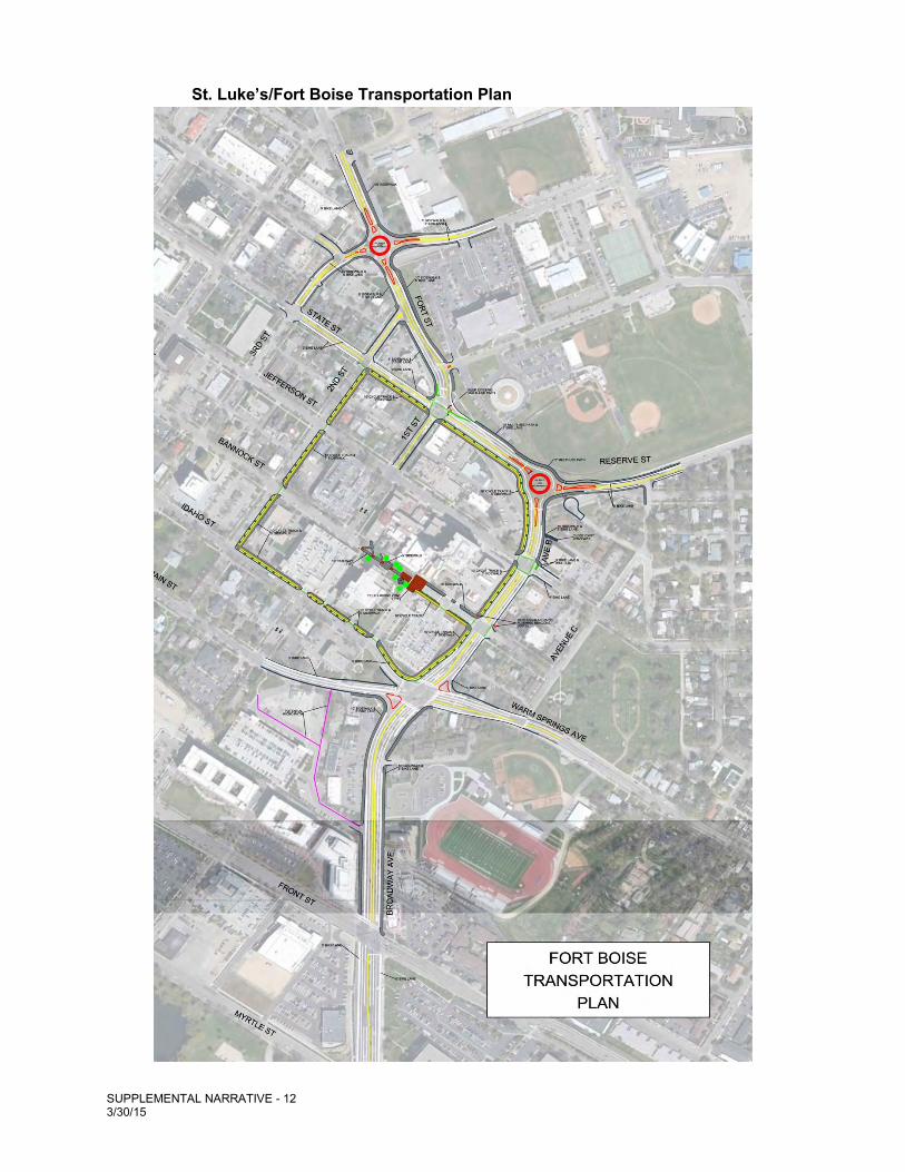
As stated in the Master Plan, St. Luke’s is committed to working with the agencies in connection with a three-party development agreement, which would allow all parties to achieve transportation improvements desired by the majority of stakeholders on an accelerated schedule. As shown on the St. Luke’s/Fort Boise Transportation Plan below, these improvements include:
Increased traffic safety; Improved traffic operations and circulation; Traffic calming through reduced vehicle speeds; Increased bike and pedestrian safety; Increased bike and pedestrian alternative choices; Opportunities for enhanced green space and streetscape amenities; and Advanced construction of infrastructure improvements through up-front financing.27
24 See, Staff Recommendation, Staff Report, Pages 20-22. 25 Blueprint Boise Goal NE-CCN 3.0: Fort Boise Area: Create an area plan, including the Armory site and other
public property on the west and north side of Fort Boise Community Center, from Reserve Street to 4th Street on the north side of Fort Street which will identify opportunities for mixed-use development of neighborhood commercial, office and residential uses, workforce housing and public open space.
26 See, http://pds.cityofboise.org/planning/comp/fortboise/. The City’s desire to develop a public-private partnership is
in keeping with the policies outlined in Blueprint Boise. See, e.g., Policy EC 8.1: Public Private Partnerships: Maintain and develop public/private partnerships that help support downtown development efforts.
27 Master Plan, Page 23.
SUPPLEMENTAL NARRATIVE - 12 3/30/15
St. Luke’s/Fort Boise Transportation Plan
SUPPLEMENTAL NARRATIVE - 13 3/30/15
Not all potential transportation system improvements are shown on the St. Luke’s/Fort Boise Transportation Plan above and we apologize for the small scale; there is just too much detail for the purpose of this Supplemental Narrative. The three-party development agreement would involve an iterative process that allows St. Luke’s, the City and ACHD to develop the engineering and design details for further review in connection with the vehicular, bicycle and pedestrian improvements in and around the St. Luke’s/Fort Boise area. And, as Staff told the Commission, if the three-party development agreement does not proceed as expected, then the City would ask that ACHD not allow vacation of Jefferson. 28 The three-party development agreement (along with improvements to Bannock Street) is clearly a key component of the mitigation and enhancement effort by St. Luke’s and is clearly a key component of Staff’s recommendation to approve the Master Plan. Yet, only one Commissioner raised a single question regarding the development agreement, and there was no Commission deliberation on how the development agreement and the St. Luke’s/Fort Boise planning efforts informed Staff’s recommendation for approval.
Mitigation of Jefferson Closure and Conformance with Blueprint Boise Staff made its recommendation to the Commission that findings necessary to approve St. Luke’s proposed amendment to Blueprint Boise may be made provided the following City-recommended additions to connectivity are addressed, notably in connection with Bannock Street:
The changes to the plan recommended by the City will adequately mitigate for loss of street connectivity on Jefferson Street by providing alternative connectivity enhancements on Bannock Street as well as on other streets in the vicinity and through a cooperative agreement with St. Luke's and ACHD will create transportation and pedestrian improvements in the area that go beyond what St. Luke’s would normally be required to provide. (Emphasis added.)
At its February 9, 2015, public hearing, the Commission, especially Commissioner Gillespie, concluded:
With respect to the mitigation that Director Simmons I think worked extremely hard on, again, I think it might be possible to mitigate the effect of closing Jefferson. I think the key to that is the Bannock street corridor. 29 (Emphasis added.)
Commissioner Gillespie went on to encourage stakeholders to work out the complications that the Bannock Street corridor presents. After the Commission’s hearing, St. Luke’s examined all public comments regarding connectivity and Staff’s proposals for how St. Luke’s Master Plan could better implement the goals and policies of Blueprint Boise.
28 Staff Report, Page 22. 29 City of Boise, Planning & Zoning Commission Meeting Minutes, Page 74.
SUPPLEMENTAL NARRATIVE - 14 3/30/15
A. Working with Stakeholders St. Luke’s heard and listened to the concerns of the public and the Commissioners regarding maintaining safe linkages between the East End and Downtown. The overwhelming theme from the Commission’s public hearing was that a more pedestrian and cycling oriented route from the East End to Downtown needed to be maintained and/or created to mitigate the closure of a block of Jefferson Street. To address these concerns, and in response to Staff recommendations, St. Luke’s conducted a focused workshop on March 6, 2015, to discuss the design of the Bannock Street corridor30 (“Bannock Design Workshop”). The Bannock Design Workshop was facilitated by a third-party urban planning and design expert, Mr. Brian McCarter of ZGF Architects from Portland, Oregon, with the intended outcome of conducting an open and unbiased review of all of the current demands for this particular section of Bannock Street. In addition, another goal was to develop alternative design concepts intended to address all uses of the Bannock space, while accomplishing three things: (1) increased patient safety; (2) increased public safety; and (3) enhanced public connectivity as part of a broader transportation system. After reviewing current conditions and current uses along with future demands, the workshop attendees provided perspectives on the best ways to balance all the competing uses of the Bannock space, with the overall need to provide connectivity in the Master Plan. Three design concepts for Bannock emerged as potential solutions to mitigate the closure of Jefferson Street and improve the overall connectivity of St. Luke’s Master Plan. Each of the design concepts for Bannock is discussed in detail in the Technical Memorandum included in Appendix C. As a result of these efforts, St. Luke’s is proposing to modify its Master Plan with these enhancements on the Bannock Street corridor:
Extend the cycle track from Avenue B to Avenue A along the south side of Bannock to provide a clear route for cyclists through this main vehicle entrance to the hospital. This will identify a specific location for cyclists that will facilitate safe comingling of vehicles, pedestrians, and cyclists;
Provide visually identifiable pathways for the cyclists in transition zones which serve as visual cues for both pedestrians and cyclists to enhance safe passage for both users;
Proved “sharrow” demarcation along Avenue A from Bannock Street to Idaho Street allowing for alternative pathways for cyclists if activity levels within the Bannock plaza are perceived as a challenge; and
Provide an enhanced 10-foot wide multi-use path through the Bannock plaza, with visually identifiable yield zones for cyclists at pedestrian crossings; and
Provide the City a public easement through the Bannock plaza to preserve this corridor as a publicly-accessible space into perpetuity.
The Bannock Design Workshop concepts, while not the full range of potential designs for Bannock, demonstrate that the opening and redesign of Bannock for pedestrian and bicycling will effectively mitigate many of the concerns expressed by the community regarding
30 Bannock Corridor Design Workshop, March 6, 2015, Technical Memo (hereinafter, “Technical Memorandum”) included in Appendix C. The Bannock Design Workshop included the participation of over 20 individuals representing the City, ACHD, East End residents, the cycling community, as well as employees of St. Luke’s. A complete list of attendees is included in Appendix C.
SUPPLEMENTAL NARRATIVE - 15 3/30/15
connectivity and safety. These concepts demonstrate that Bannock can be redesigned as a safe corridor for the East End to access Downtown without traversing from Fort Street to State Street. Due to the high interest in the Bannock Street corridor, St. Luke’s understands that the final design components for this space will be critical to achieve the objectives of all parties. To that end, St. Luke’s is committed to working with all stakeholders to develop optimal solutions that represent the appropriate balance between all interests in this key element of the Master Plan. Of course, the final design for Bannock will emerge through ongoing workshops with the community.
B. Diversity within the Cycling Community It is important to remember that the cycling community is diverse and that understanding their differing needs is critical to designing bikeway corridors. The Portland Bureau of Transportation has categorized cyclists and potential cyclists into four distinct riding types: (1) “Strong and the Fearless”; (2) “Enthused and Confident”; (3) “Interested but Concerned”; and (4) non-riders, called the “No Way No How” group. 31 We believe these groups are also representative of the cycling community in Boise. The “Strong and the Fearless” group are those bicyclists for whom “riding is a strong part of their identity and they are generally undeterred by roadway conditions.”32 This group would currently have no problem riding on Fort Street or Avenue B during rush hour. This is a small percentage of the overall cycling community. The “Enthused and Confident” group is composed of those cyclists that enjoy cycling within Boise and who are comfortable sharing the roadway with automotive traffic, but prefer to do so on streets that have been designed to work well for bicycling (streets with bicycle lanes and streets with lower traffic counts). This group is composed of recreational cyclists as well as daily commuters. The “Interested but Concerned” group is composed of “residents curious about bicycling…. They don’t like the cars speeding down their streets. They get nervous thinking about what would happen to them on a bicycle when a driver runs a red light, or gun their car around them, or pass too closely and too fast. Very few of these people regularly ride bicycles [for commuting purposes] — [they may] ride through their neighborhoods to the local park or coffee shop, but who will not venture out onto the arterials to the major commercial and employment destinations they frequent. They would ride if they felt safer on the roadways—if cars were slower and less frequent, and if there were more quiet streets with few cars and paths without any cars at all.”33 A component of this group is families trying to bicycle with younger family members in a safe manner. The final group is comprised of the “No Way, No How” folks. This group is not interested in bicycling but they should be considered when designing bicycle and pedestrian connections.
31 https://www.portlandoregon.gov/transportation/article/158497 32 https://www.portlandoregon.gov/transportation/article/158497 33 https://www.portlandoregon.gov/transportation/article/158497
SUPPLEMENTAL NARRATIVE - 16 3/30/15
Given this wide variety of cyclists and potential cyclists, St. Luke’s is committed to working with all members of the community to develop bikeway connections that work well for both the “Strong and the Fearless” all the way down the continuum to the “Interested but Concerned” group. The Bannock Design Workshop is an example of St. Luke’s ability and genuine interest in working with neighbors, experts, and other stakeholders to develop the best solutions to connectivity. This attitude of working cooperatively will continue through the design process of Bannock.
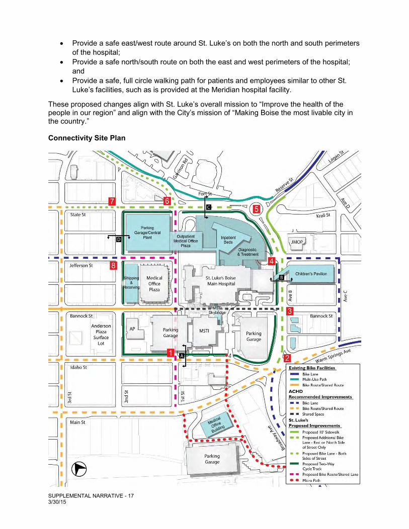
C. Additional Suggested Improvements for Connectivity within the Master Plan During the Commission’s hearing, St. Luke’s heard testimony that families and others were reluctant to use Fort Street, Idaho Street and State Street for bicycling and pedestrian activities. The same comments were made at the Bannock Design Workshop. This testimony demonstrates that connectivity for bicycles and pedestrians does not currently exist on Idaho Street, Avenue B, Fort Street and State Street, and that such connectivity will not exist unless the improvements contemplated in the Master Plan are completed. The proposed improvements will establish comfortable co-existence of automobiles, bicycles, and pedestrians that does not currently exist within the St. Luke’s area.34 The Bannock Design Workshop also produced certain suggested improvements for connectivity within the Fort Boise area. These suggestions focus on five enhancements and are listed below, and shown on the Connectivity Site Plan:
Extend two-way cycle track on Avenue B from Jefferson Street north to State Street, then west to 2nd Street;
Enhance intersections to inform cyclists of route options; Enhance cyclists’ facilities on 2nd Street to encourage use of 2nd Street to access
Jefferson or Bannock Streets; Extend two-way cycle track west on Idaho Street so that it rings the St. Luke’s
facility; and Enhance intersections to encourage/inform cyclists of buffered bike lanes on
Idaho and Main Streets.
Again, in response to the input from the Bannock Design Workshop, St. Luke’s is proposing to revise the Master Plan, by extending the cycle track concept to complete a safe walking/two-way cycling path around the St. Luke’s facility. This includes extending the current proposed cycle track from:
Jefferson to 2nd Street, along the west side of Avenue B, and the south side of Fort and State Streets;
State Street to Idaho Street along the east side of 2nd Street; and 2nd Street to Avenue B along the north side of Idaho Street.
These changes are reflected in the revised Connectivity Site Plan below. Please note that number 3 through 7 in the red squares on the Connectivity Site Plan relate to the renderings found in Appendix D. St. Luke’s is proposing these changes to:
34 The Master Plan meets Blueprint Boise Policy CC2.2: Street Design: … (b) Consider all travel modes in the design of streets.
SUPPLEMENTAL NARRATIVE - 17 3/30/15
Provide a safe east/west route around St. Luke’s on both the north and south perimeters of the hospital;
Provide a safe north/south route on both the east and west perimeters of the hospital; and
Provide a safe, full circle walking path for patients and employees similar to other St. Luke’s facilities, such as is provided at the Meridian hospital facility.
These proposed changes align with St. Luke’s overall mission to “Improve the health of the people in our region” and align with the City’s mission of “Making Boise the most livable city in the country.” Connectivity Site Plan
SUPPLEMENTAL NARRATIVE - 18 3/30/15
The Jefferson Street closure mitigation activities provided in St. Luke’s application should be viewed as examples and concepts that prove mitigation is surely possible. St. Luke’s believes that the additional cycling and pedestrian improvements outlined in the Master Plan and the Bannock Design Workshop, and as further refined by workshops similar to the Bannock Design Workshop, will ultimately be embraced by the East End community once they become familiar with how they function and the level of safety they provide to the user.
D. Conformance with Blueprint Boise Goals and Policies for Connectivity/Transportation The overwhelming concern raised in meetings with stakeholders has been the closure of a block of Jefferson Street and the desire to maintain connectivity to Downtown from the East End. But, as stated in the Staff Report: “Due to low traffic volumes as documented in the TIS, Jefferson is not technically necessary to convey traffic and pedestrians through the campus area, but it is a component of the Downtown grid that allows for safe and flexible transportation options.”35 (Emphasis added.) As indicated in the TIS, St. Luke’s has considered all travel modes in preparing the Master Plan and has worked to provide additional “safe and flexible transportation options” that mitigate the closure of a block of Jefferson Street and conform with Blueprint Boise. St. Luke’s worked extensively with Staff, ACHD, and stakeholder groups–including residents and representatives of the East End neighborhood–to consider the needs of not only vehicular traffic capacities within the St. Luke’s/Fort Boise areas but also pedestrian and bicycle activity.36 St. Luke’s explored opportunities to improve connectivity in existing neighborhoods through the implementation of various features such as roundabouts, cycle tracks, multi-use paths, significant addition of bicycle facility striping (e.g., sharrows, lanes, green boxes, etc.), micro-pathways, and the redesign of Bannock, all in an effort to meet the goal of an interconnected network of complete streets.37 Renderings detailing the proposed improvements to Idaho Street, Avenue B, Fort Street, and 2nd Street are included in Appendix D. These renderings demonstrate that the existing street network will be significantly improved to distribute vehicles, bicycles, and pedestrians to multiple streets.
35 PDS Staff report dated February 9, 2015, Page. 22. As noted earlier, a grid street can provide flexible transportation options, but it is not the only way and, depending on the circumstances, not necessarily the safest way.
36 The Master Plan meets Blueprint Boise Goal CC2: Create an interconnected network of complete
streets that serve all modes of transportation. 37 The Master Plan meets Blueprint Boise Policy CC2.1: Connectivity:
(a) Develop a street network that interconnects and distributes vehicle, bicycle, and pedestrian traffic to multiple streets…
(c) Explore opportunities to improve connectivity in existing neighborhoods without widening existing streets. (d) Prioritize maintenance of existing roadway facilities over construction of new roadways.
SUPPLEMENTAL NARRATIVE - 19 3/30/15
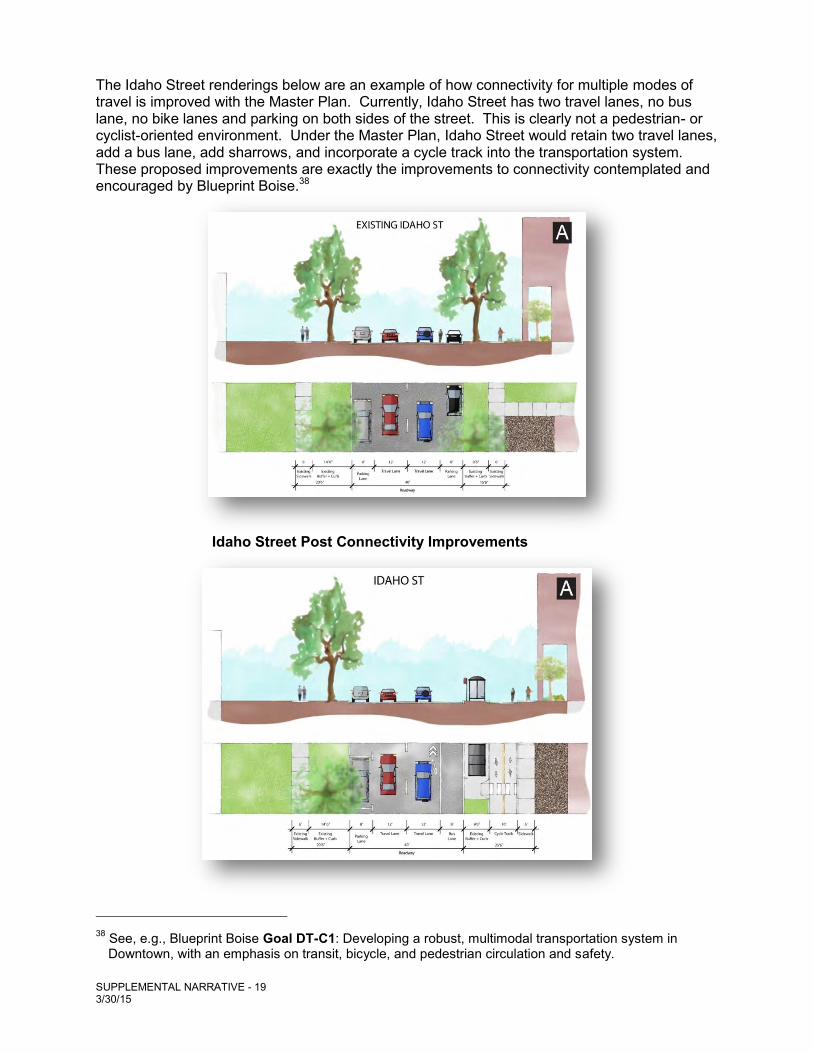
The Idaho Street renderings below are an example of how connectivity for multiple modes of travel is improved with the Master Plan. Currently, Idaho Street has two travel lanes, no bus lane, no bike lanes and parking on both sides of the street. This is clearly not a pedestrian- or cyclist-oriented environment. Under the Master Plan, Idaho Street would retain two travel lanes, add a bus lane, add sharrows, and incorporate a cycle track into the transportation system. These proposed improvements are exactly the improvements to connectivity contemplated and encouraged by Blueprint Boise.38
Idaho Street Post Connectivity Improvements
38 See, e.g., Blueprint Boise Goal DT-C1: Developing a robust, multimodal transportation system in Downtown, with an emphasis on transit, bicycle, and pedestrian circulation and safety.
SUPPLEMENTAL NARRATIVE - 20 3/30/15
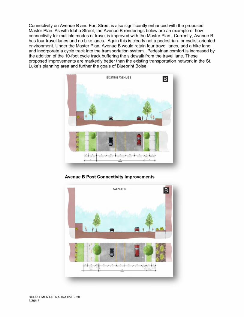
Connectivity on Avenue B and Fort Street is also significantly enhanced with the proposed Master Plan. As with Idaho Street, the Avenue B renderings below are an example of how connectivity for multiple modes of travel is improved with the Master Plan. Currently, Avenue B has four travel lanes and no bike lanes. Again this is clearly not a pedestrian- or cyclist-oriented environment. Under the Master Plan, Avenue B would retain four travel lanes, add a bike lane, and incorporate a cycle track into the transportation system. Pedestrian comfort is increased by the addition of the 10-foot cycle track buffering the sidewalk from the travel lane. These proposed improvements are markedly better than the existing transportation network in the St. Luke’s planning area and further the goals of Blueprint Boise.
Avenue B Post Connectivity Improvements
SUPPLEMENTAL NARRATIVE - 21 3/30/15
E. Pedestrian Comfort The Master Plan enhances the pedestrian experience and is in conformance with Blueprint Boise.39 As previously discussed, the reconfiguration of Bannock will allow pedestrians to move easily between Downtown and the East End. As stated by the Commission this is “key” to the closure of a block of Jefferson Street.40 In addition, there are multipath and micro-path systems provided for as shown on the Connectivity Site Plan shown earlier.41 These proposed improvements connect destinations with new pedestrian facilities and encourage walking for a wide variety of trips by adding sidewalk connections and restoring damaged sidewalks.42 The completion of the cycle track on Fort Street, State Street, Idaho Street and Avenue B will work to minimize pedestrian conflict by providing buffers between the sidewalk, bicycling and automobile traffic.43 One of the common concerns voiced during the public hearing was about safety on Fort Street. The Master Plan has been designed to protect the most vulnerable street users by maximizing pedestrian safety and comfort in the design of pedestrian crossings.44
F. Bicycle Network The Master Plan’s connectivity elements for bicycles are truly innovative. The bicycle facilities will expand the designated network of bicycle lanes and routes connecting the East End to Downtown (and beyond), and will advance the bicycle network goals and policies of Blueprint
39 See Blueprint Boise Policy DT-C 1.6: (a) Create a network of safe, attractive pedestrian routes in Downtown to encourage walking as a transportation mode and as an enjoyable part of the Downtown experience. (b) Continue to work with the DBA to create attractive and lively streets and explore potential partnerships with local businesses to promote walking in downtown. (c) Develop a comprehensive way-finding system for Downtown featuring pedestrian scale signage to mark walking routes and show direction, distance/time, and access to: points of interest, community services, public buildings, transit, trails and parks, and major activity centers. (d) Promote installation and evaluation of enhanced pedestrian countdown signals, crosswalk markings, leading pedestrian intervals, expanded audible pedestrian signal program, installing new accessible pedestrian pushbuttons, increasing pedestrian walking times to cross signalized intersections, and implementing and evaluating pedestrian scramble phases which enable pedestrians to cross at a signalized intersection in all directions at the same time while drivers are stopped.
40 City of Boise, Planning & Zoning Commission Meeting Minutes, Page 74. 41 See Blueprint Boise Policy CC7.1: (a): Connect destinations with pedestrian facilities and encourage
walking for a wide variety of trips by adding sidewalk connections, restoring damaged sidewalks and requiring sidewalks is part of development approvals. (b) Collaborate with ACHD, ITD, neighborhood associations, and schools to fix "gaps" in the pedestrian system that were identified through the ACHD Pedestrian – Bicycle Transition Plan.
42 See Blueprint Boise Goal CC7: Enhance pedestrian connectivity and comfort. 43 See Appendix D. 44 See Blueprint Boise Policy DT-C 2.6: Connections to Major Activity Centers: Enhance connections
between the Downtown core and the St. Luke’ Regional Medical Center and BSU campuses. See Appendix D for schematic drawings of example of bicycle facilities proposed. The final design and engineering will be accomplished through facilitated meetings with the City, ACHD and stakeholders, as well as formal public hearings.
SUPPLEMENTAL NARRATIVE - 22 3/30/15
Boise.45 These proposed connectivity elements are improvements to the existing bicycle network, and their impacts to cycling safety will be enjoyed by a full range of users within the St. Luke’s planning area as part of their daily commute. As previously discussed, the cycling community is diverse; improvements enjoyed by some groups, for example, the “Strong and the Fearless,”, may be avoided by others, such as the “Interested but Concerned” cyclists. Given this dynamic, St. Luke’s has designed for the full spectrum of cycling user groups. It is anticipated that the creation of these improvements will facilitate and encourage the use of bicycles for transportation and recreation on streets that (at least according to public testimony) are considered too dangerous for the casual rider to enjoy.
G. Education of Users St. Luke’s understands that some of the elements for pedestrian and cycling connectivity within the Master Plan are new to the Boise community and, as such, St. Luke’s is committed to using its resources to help to educate users on how to enjoy these amenities. In that regard, St. Luke’s will work with the cycling community, local governments and stakeholders to help formulate an education plan and materials for the general public and St. Luke’s employees that cover, for example: how to interpret visual cues; how to safely use the cycle track facilities; how pedestrians, cyclists and automobiles can safely interact within shared spaces; how to enter and exit a roundabout; and other concerns that may develop as the ultimate design of the cycling and pedestrian improvements is finalized. Preventive education, care and safety are exactly in line with St. Luke’s mission, vision and values. The Way Forward/Conclusion We trust that this Supplemental Narrative, and the record as a whole, presents the facts to support the legal conclusions the Council must reach to approve St. Luke’s application for an amendment to Blueprint Boise. We respectfully request that the Council approves the Master Plan with the knowledge and understanding that there will be continuing efforts by St. Luke’s, local government agencies and stakeholders to implement the goals and objectives of the Master Plan. These efforts include:
St. Luke’s will work with the City’s Attorney’s office to draft an easement granting permanent public access to the vacated portion of Bannock Street between Avenue B and 1st Street for use by bicyclists and pedestrians. The space will be shared with St. Luke’s employees, patients and patrons.
St. Luke’s will continue to work with the City and stakeholders in connection with the landscape/hardscape design for the Bannock area to improve the access and experience.
45 See, e.g., Goal CC8: Enhance bicycling connectivity and comfort: Blueprint Boise Policy DT-C 1.5: Bicycle Network: (a) Create a network of designated bicycle lanes and routes in Downtown, and expand bicycle facilities and amenities to encourage the use of bicycles for transportation and recreation. (b) Implement the improvements to the bicycle network identified in the Downtown Boise Mobility Study – Implementation Program as resources allow. (c) Increase the supply of bicycle racks and lockers, and explore the use of bicycle corrals, in Downtown to expand end-of-trip facilities for bicyclists. (d) Work with developers to add bicycle lanes and route markings along development frontages if they are on the bicycle network.(e) Encourage developers to include bicycle parking and showers in project designs as appropriate.
SUPPLEMENTAL NARRATIVE - 23 3/30/15
St. Luke’s will continue to work with the City and ACHD to draft a development agreement in connection with the design, approval, funding and construction of multi-modal transportation improvements in the St. Luke’s/Fort Boise area.
St. Luke’s will continue to work with the City and stakeholders in connection with the design of buildings and landscape improvements that will eventually be reviewed by the City’s Design Review Committee.
St. Luke’s will continue to work with the City, ACHD and stakeholders in connection with the design of the multimodal transportation system to be reviewed by ACHD.
St. Luke’s will continue to work with the City and historic preservationists in connection with the relocation of identified, older structures.
SUPPLEMENTAL NARRATIVE - 24 3/30/15
Frequently Asked Questions
Q: What is St. Luke’s commitment to the community?
St. Luke’s has been invested in, and investing in this neighborhood, the East End, since December 1, 1902. St. Luke’s embraces an ongoing and steadfast commitment to its not-for-profit mission to provide real and tangible benefits for the entire community. St. Luke’s 2014 Community Benefit Report filed with Ada County is attached as Appendix E. During the Master Plan review process, some individuals have written to the City to oppose the Master Plan based on their opinion that St. Luke's is just a big corporation asking for the closure of a block of Jefferson as a subsidy from Boise residents. We hope that our presentation to the Council, and the record as a whole, conveys to the City and the public that, yes, with the closure of a block of Jefferson, St. Luke's is asking that the public invest in its health care and connectivity. We also hope that the public recognizes that, in return, St. Luke's is investing in the public infrastructure substantially by providing enhanced, safer connectivity in the East End, St. Luke's campus, Fort Boise and Downtown areas.
Q: Was the public included in the evaluation that resulted in the North
Alternative being selected?
A major tenet of modern, smart growth urban land use planning is that community and stakeholder collaboration is encouraged in development decisions. Appendix A contains a partial list of the meetings held and open house presentations used to involve the local governments, neighbors, cycling and historic preservation organizations and neighborhood associations in assisting to refine the Master Plan. St. Luke’s has and continues to listen to its neighbors and other community stakeholders and has incorporated suggestions into the proposed Master Plan. The general public was not involved with the internal health care planning that took St. Luke’s and its very specialized consultants several years before a proposed plan based on the North Alternative could even be presented to the general public for input. That is to be expected because hospital planning is the epitome of form follows function. Patient care and safety, along with the functionality of a hospital, is a highly technical field made more complex with regulatory requirements. Academic treatises and hundreds of professional articles are written on the subject each year. Health care facility planning differs significantly from other campuses where one would plan with different building blocks, such as an administration building, law library, architecture school, etc. Health care facility planning is unique. Health care planning is analogous to other highly specialized industries. Patient care and safety is not simply our ultimate goal – it is our most sacred trust. St. Luke’s understands that it must, as a health system, plan its built environment for patient care and safety to begin with and then, the next step is to determine if the health care planning can be balanced within the overall land use goals and policies of the comprehensive plan. We completely understand that we must do this, and we firmly believe that we have balanced patient care and safety with other Blueprint Boise goals and policies. Some of our East End neighbors have told us that St. Luke’s needed to
SUPPLEMENTAL NARRATIVE - 25 3/30/15
start with the existing street grid system, take that as an absolute, and then try to work health care planning around that. We did. It didn’t work.
Appendix B describes the different alternatives explored in an attempt to accommodate health care planning without impacting this block of Jefferson Street. Although we appreciate the urban planning concepts associated with a smaller building footprint on a grid system of streets, if patient care and safety cannot be accommodated within those constraints, then, from sound health care planning, it is appropriate to look at whether the urban planning concept of a smaller building footprint on a grid system of streets should be tempered somewhat.
Perhaps we have to “agree to disagree” on where planning starts: patient care and safety versus a smaller building footprint on a grid street system. Starting from the gridded street system, St. Luke’s cannot achieve the health care planning goals for patient care quality and safety, and we’ve been offered no reasonable mitigation suggestions from our neighbors. Starting from patient care and safety, we can achieve the health care goals we believe are critical for our community and, with the collaborative assistance of the local government and citizens, we can also achieve the physical connectivity goals of the City with mitigation to the multimodal transportation system.
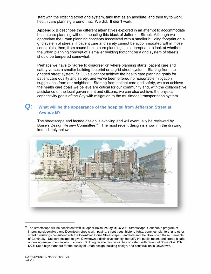
Q: What will be the appearance of the hospital from Jefferson Street at Avenue B?
The streetscape and façade design is evolving and will eventually be reviewed by Boise’s Design Review Committee.46 The most recent design is shown in the drawing immediately below.
46 The streetscape will be consistent with Blueprint Boise Policy DT-C 2.3: Streetscape: Continue a program of improving sidewalks along Downtown streets with paving, street trees, historic lights, benches, planters, and other street furnishings consistent with the Downtown Boise Streetscape Standards and the Downtown Boise Elements of Continuity. Use streetscape to give Downtown a distinctive identity, beautify the public realm, and create a safe, appealing environment in which to walk. Building facade design will be consistent with Blueprint Boise Goal DT-NC4: Set a high standard for the quality of urban design, building design, and construction in Downtown.
SUPPLEMENTAL NARRATIVE - 26 3/30/15
The view of the hospital from Jefferson looking west across Avenue B is first affected by the streetscape, which includes varying paving treatments, landscape screening and appropriate pathway lighting at the pedestrian/bicyclist level. The view beyond the streetscape includes (presumably; final decisions on materials and design will reside with the City’s Design Review Committee) brick walls terracing up to the ambulance driveway, interspersed with landscaping. The building façade beyond will be modulated to recess the first floor underneath the floor above, which, in turn, is modulated to add visual interest to the second through fifth floors. The façade then steps back again at the sixth floor level. Traveling around the north side of the new building addition, along the south side of Fort Street, one would see landscape on both the hospital side and the street side of the multipurpose walkway/bike path. The hospital’s north wall would undulate to break up the overall mass, and also provide niches, or pockets, for public seating alcoves and recesses. Public drinking fountains, with integral dog waters, and brick seating walls with views of the foothills to the north would be included in the streetscape. As one approaches 1st Street, the hospital steps back from the street providing more landscaped terracing, and wider views for a safe approach to the improved intersection. Traveling south on 1st Street, one would first notice the new drive and walkways up the new entrance to the hospital. Proceeding further south under the medical office building to the intersection with Jefferson Street, one would see the new public pocket park to the east that provides a place of respite for the public, patients, visitors, and staff. The pocket park will be designed to include landscape, paved pathways, seating on benches and short walls, public art, and terraces down to outdoor dining.
Q: What would happen to the giant sequoia tree on Avenue B?47
All trees and shrubs on St. Luke’s campus have had a preliminary assessment for health. Final assessment of health will be provided by an arborist. Trees to be removed and that are also assessed as healthy will require mitigation as outlined in the City’s Landscape Ordinance.48 Healthy desirable trees that have a caliper of four inches or greater that are removed are to be replaced with an equal replacement of the total caliper removed. There has been discussion about moving the giant sequoia located near Avenue B. A transplant specialist (for example, Environmental Design or Senna Tree C) will be contacted.49
47 For further information, please refer to the Landscape Assessment prepared for St. Luke’s Health System and filed with the City in connection with the application.
48 See, Boise City Code Section 11-07-05.2.F. 49 Boise defines sustainability as living or acting in a manner that improves our quality of life, promotes a
strong economy, and conserves our natural resources. Since 1998, over 50 businesses have been honored with Boise’s EnviroGuard Sustainability Award, which recognizes Boise businesses that are reducing their environmental footprint. Since 2005, St. Luke's has expanded its efforts to reduce its environmental footprint by implementing additional energy conservation measures, a campus-wide recycling program, an alternative transportation program, and using biodegradable packaging and certified green cleaning products. These efforts have earned St. Luke's Boise’s EnviroGuard Sustainability Award. See, http://publicworks.cityofboise.org/environmental-resource-center/enviroguard-sustainability-awards/.
SUPPLEMENTAL NARRATIVE - 27 3/30/15
Q: Will the hospital development protect historic properties?
The City has taken steps to protect many historic properties in the City through the designation of historic overlay districts. St. Luke’s campus is not in an historic overlay district, yet, as discussed in Section 6.0 of the Master Plan, there was the possibility that some properties may be historically significant. Both the East End Neighborhood Policy Guide and Blueprint Boise polices speak to protecting historic resources.50 St. Luke’s conducted an architectural survey and reviewed previously published information and research to determine whether properties were historically significant. The results were presented to participants including Preservation Idaho, Idaho State Historic Preservation Office, Idaho Heritage Trust, National Trust for Historic Preservation, City of Boise Department of Arts and History, and the City of Boise Historic Preservation Commission. The results showed that none of the properties was considered historically significant. Nonetheless, there was sentiment for preserving six historically interesting structures in place or at receiving sites. St. Luke’s is committed to continuing its collaborative effort with these preservation organizations. St. Luke’s has identified a possible relocation strategy for several of these historically interesting structures on property owned by St. Luke’s along Avenue B between Warm Springs Boulevard and Bannock Street. Newer existing structures would be removed and older structures put in their place and repurposed.
Q: Was a bike/pedestrian tunnel considered? There are several emails in the record wondering whether tunneling under Jefferson was considered, and Commissioner Danley was adamant in his view that a tunnel could work well in this circumstance. Although we agree that a tunnel could work well under the right circumstances, and we are aware of many examples from around the Country and the world, tunneling under Jefferson would not be practical or feasible in this instance.
Environmental stewardship practices of St. Luke’s support the major theme of Blueprint Boise to preserve and protect the natural resources of the City of Trees. See Blueprint Boise, Page 2-9 – 2-14. In addition to the pocket park that is planned for the area west of Jefferson (this pocket park is shown on the rendering found on the Table of Contents page of this Supplemental Narrative), St. Luke’s has a robust landscape and tree program that promotes Goal ES2: Protect surface water quality by enhancing natural watershed processes and promoting efficient water use; as well as Goal ES6: Promote a healthy urban forest to enhance the city’s environment, air quality, and appearance.
50 See Blueprint Boise: Goal NAC13: Protect historically and culturally significant resources that contribute to community identity and history; Policy NAC13.2: Inventory of Historic Places: Develop and maintain a comprehensive inventory of historic places in accordance with the goas of the Historic Preservation Plan; Policy NAC14.4: Privately Sponsored Programs: Encourage privately sponsored programs for historic preservation and rehabilitation when consistent with the public interest and to fulfill the purpose of the Historic Preservation Plan; and Policy NAC16.3: Coordination: Integrate historic preservation with the city’s urban, land-use, and other public planning processes that relate to the visual, aesthetic, and cultural environment.
East End Neighborhood Policy Guide: “Significant historic buildings in the near East End . . . should be preserved”; and “Encourage the preservation of the historic character and scale of the near east end, and the adaptive reuse of historic structures.” Page 2-9
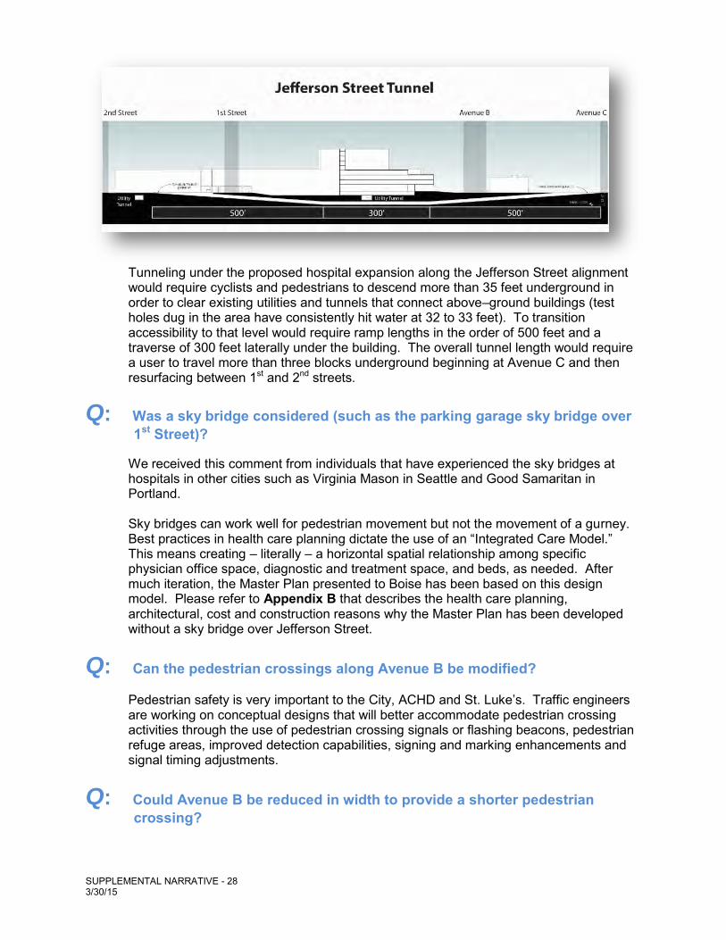
SUPPLEMENTAL NARRATIVE - 28 3/30/15
Tunneling under the proposed hospital expansion along the Jefferson Street alignment would require cyclists and pedestrians to descend more than 35 feet underground in order to clear existing utilities and tunnels that connect above–ground buildings (test holes dug in the area have consistently hit water at 32 to 33 feet). To transition accessibility to that level would require ramp lengths in the order of 500 feet and a traverse of 300 feet laterally under the building. The overall tunnel length would require a user to travel more than three blocks underground beginning at Avenue C and then resurfacing between 1st and 2nd streets.
Q: Was a sky bridge considered (such as the parking garage sky bridge over 1st Street)?
We received this comment from individuals that have experienced the sky bridges at hospitals in other cities such as Virginia Mason in Seattle and Good Samaritan in Portland. Sky bridges can work well for pedestrian movement but not the movement of a gurney. Best practices in health care planning dictate the use of an “Integrated Care Model.” This means creating – literally – a horizontal spatial relationship among specific physician office space, diagnostic and treatment space, and beds, as needed. After much iteration, the Master Plan presented to Boise has been based on this design model. Please refer to Appendix B that describes the health care planning, architectural, cost and construction reasons why the Master Plan has been developed without a sky bridge over Jefferson Street.
Q: Can the pedestrian crossings along Avenue B be modified?
Pedestrian safety is very important to the City, ACHD and St. Luke’s. Traffic engineers are working on conceptual designs that will better accommodate pedestrian crossing activities through the use of pedestrian crossing signals or flashing beacons, pedestrian refuge areas, improved detection capabilities, signing and marking enhancements and signal timing adjustments.
Q: Could Avenue B be reduced in width to provide a shorter pedestrian crossing?
SUPPLEMENTAL NARRATIVE - 29 3/30/15
At the request of the City, CH2MHill traffic engineers studied the effect that reducing the width of Avenue B would have on surrounding traffic operations. The complete technical memorandum of the study was filed with the City along with St. Luke’s application. This “road diet” concept would reduce the number of lanes on Avenue B and Fort Street from a 5-lane to a 3-lane section from Warm Springs Avenue to 1st and Fort Streets. Desirably, the modification would: accommodate bicycle and pedestrian facilities; make crossing of Avenue B better for pedestrians; divert traffic away from Avenue B; and make efficient use of other facilities such as Idaho and Main Streets and north-south streets west of the hospital. However, the detailed analysis found that because of the limited benefit, coupled with significant negative impacts, a road diet along Avenue B is not an appropriate engineering solution. Even with a reduction to 3 lanes, there is still significant travel demand along
Avenue B such that Avenue B will operate with poor levels of service and a volume to capacity ratio nearing or exceeding capacity;
Three of 4 intersections reviewed within this section will exhibit very poor levels of service and a volume to capacity ratio nearing or exceeding capacity;
Redistribution of traffic shows increased travel demand along several downtown corridors; additional capacity in those corridors, in the form of auxiliary turn lanes, will likely be needed;
Traffic queues are expected to extend beyond adjacent intersections; resulting intersection queues will be unable to clear at every cycle;
The increase in control delay at each intersection will add nearly 3 minutes of travel time from the intersection of Avenues B and Warm Springs to 1st and Fort Streets, which will affect timely response to emergency needs;
Impacts related to air quality and fuel consumption can be expected with the increased congestion;51 and
With significant congestion, at uncontrolled intersections, even with the reduced width of Avenue B, it is expected that pedestrian crossing opportunities will be limited.
Please refer to the question immediately above. St. Luke’s and its traffic engineers will continue to work with local governments and stakeholders to further the conceptual designs toward solutions for pedestrian crossings. It may be unlikely that Avenue B could practically be reduced in width and Staff reported to the Commission that a reduction in width was not likely acceptable to ACHD. Still, it is our understanding that the City has requested that ACHD review the road diet concept further.
51 Road reconstruction that increased congestion could be contrary to Blueprint Boise Policy CC1.5: Emissions:… (b) Coordinate with ACHD, ITD, and COMPASS to identify areas of high congestion and delay and to create solutions that improve traffic flow and minimize vehicle time spent idling and accelerating while balancing the needs of alternative transportation modes.
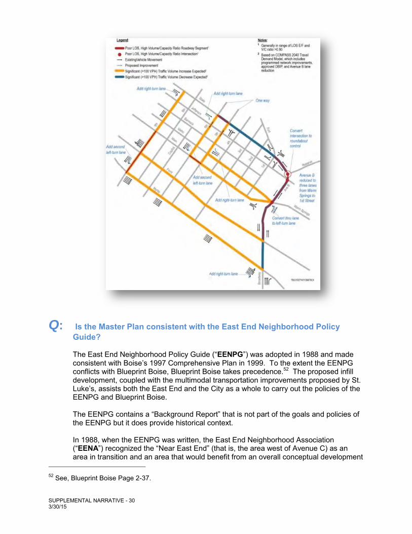
SUPPLEMENTAL NARRATIVE - 30 3/30/15
Q: Is the Master Plan consistent with the East End Neighborhood Policy Guide?
The East End Neighborhood Policy Guide (“EENPG”) was adopted in 1988 and made consistent with Boise’s 1997 Comprehensive Plan in 1999. To the extent the EENPG conflicts with Blueprint Boise, Blueprint Boise takes precedence.52 The proposed infill development, coupled with the multimodal transportation improvements proposed by St. Luke’s, assists both the East End and the City as a whole to carry out the policies of the EENPG and Blueprint Boise.
The EENPG contains a “Background Report” that is not part of the goals and policies of the EENPG but it does provide historical context. In 1988, when the EENPG was written, the East End Neighborhood Association (“EENA”) recognized the “Near East End” (that is, the area west of Avenue C) as an area in transition and an area that would benefit from an overall conceptual development
52 See, Blueprint Boise Page 2-37.
SUPPLEMENTAL NARRATIVE - 31 3/30/15
plan, 53 and that “[g]enerally, traffic should be routed around interior sections of the neighborhood whenever possible, and should be concentrated along corridors as opposed to dispersal through the neighborhood.”54 In 1988, Avenue B was proposed for extension to tie Broadway to State Street. At that time, EENA asked ACHD to re-evaluate the plan to extend Avenue B suggesting that 3rd Street be used instead to connect to Broadway Avenue.55 It also noted that if Avenue B was determined to be the most efficient and cost-effective alternative, then special consideration should be given during the design phase to ensure safe and adequate multimodal access into the downtown area from the East End.56 The EENPG goal and policies applicable today continue to recognize the transitional nature of the Near East End, the desire to route traffic around the interior of the neighborhood and that special consideration should be given to the design of Avenue B for “safe and adequate bicycle/pedestrian crossings between the main part of the East End Neighborhood and the downtown area.”57
53 “Residents recognize the near East End (the area from Avenue C to Sixth Street [now 3rd] as an area in
transition, with single–family residences unlikely to remain a significant component of mixed land use. Pressures for changing land use have come from the expansion of the St. Luke's Hospital complex, movement of the downtown core to the east, with its conversion of residences to offices, and the proposals for major transportation corridors through the area.
The neighborhood recognizes that site plans and the design of structures are chief functions of the architect and the developer. However, the redevelopment of an area as large as the Near East End can best be accomplished by a conceptual plan for the area which provides a framework for architects and developers to work with. To do otherwise is to allow individual projects to set precedents, preclude options and established land uses in a piecemeal, checkerboard fashion.” See, EENPG Background Report, Page 3-11.
54 See, EENPG Background Report, Page 2-4. 55 See, EENPG Background Report, Page 3-12 – 3-13. 56 See, EENPG Background Report, Page 3-12 – 3-13. 57 See, EENPG, Pages 2-1 – 2-6:
Goal: Maintain the character of the East End by recognizing its unique amenities and natural features, encouraging appropriate infill development, and allowing development in adjacent areas that does not negatively impact the existing neighborhood.
Boise City should make every effort to coordinate applications for redevelopment in or adjacent to the East End (e.g. the St. Luke’s area ...) with neighborhood concerns for residence displacement, traffic circulation, parking, visual qualities and historic buildings.
The transition of the Near East End [i.e., west of Avenue C] from residential to offices and support services is recognized, and the City will make every effort to consider the concerns of area residents and control adverse impacts.
Traffic should be routed around the neighborhood’s interior and concentrated on designated arterial/collector streets.
Arterial/collector streets within the East End [include]:
Minor Arterials: Avenue B
Jefferson Street Fort Street (Ave B to 1st)
SUPPLEMENTAL NARRATIVE - 32 3/30/15
Blueprint Boise, like the EENPG, encourages compact growth and notes that one of the most effective means of achieving a compact growth pattern is to identify opportunities to accommodate growth within the City's existing footprint, especially through the redevelopment of obsolete buildings such as found in many instances on the St. Luke's campus. Rather than rely on incentives for redevelopment, St. Luke’s, of its own volition, has striven to safeguard what St. Luke’s views as existing community assets at its Boise campus. Rather than abandon its Boise campus for easier-to-develop Greenfields, St. Luke’s is inspired by the infill development goals of Blueprint Boise.58 Based on the cross section of Avenue B today, there is very little in the way of what would be considered adequate and safe bicycle and pedestrian crossings. Very possibly, what was considered adequate in the late 1980s would not pass muster today. The implementation of the proposed Master Plan, with its extensive multimodal improvements, will go far in meeting the policies of the EENPG to provide safe and adequate multimodal infrastructure improvements – far more adequate and safe than as provided when Avenue B was originally reconstructed in the late 1980s. The goals and policies of Blueprint Boise for multimodal transportation improvements are addressed with the Master Plan.59 Further still, implementation of the Master Plan, if approved, will help the EENA ensure that vehicular traffic is encouraged to use the arterial/collector streets on the periphery of the neighborhood (including that portion of the Near East End neighborhood that is the St. Luke’s campus).
Collectors: Fort Street (1st Street to Washington)
Special consideration should be given to the design of Avenue B and 2nd Street for safe and adequate bicycle/pedestrian crossings between the main part of the East End Neighborhood and the downtown area.
58 See, e.g., Blueprint Boise Policy PDP1.1: Infill priority areas and establish incentives for infill and
redevelopment. Recognize the Downtown, designated mixed-use activity centers, major travel corridors, and other potential areas of change identified at the planning-area level as priorities for infill and redevelopment.
59 See, e.g., Blueprint Boise: Goal CC2: Create an interconnected network of complete streets that serve
all modes of transportation; Policy CC2.1(a): Connectivity: Develop a street network that interconnects and distributes vehicle, bicycle, and pedestrian traffic to multiple streets … (c) Explore opportunities to improve connectivity in existing neighborhoods without widening existing streets ... (d) Prioritize maintenance of existing roadway facilities over construction of new roadways; and Policy CC2.2 Street Design: (b) Consider all travel modes in the design of streets. While vehicular traffic flows should be carefully considered, reasonable reduction in vehicular traffic capacities and level of service should be allowed at intersections and crossings with high pedestrian and bicycle activity to safely accommodate their crossing.
As mentioned elsewhere herein, being mindful of the pedestrian activity in the vicinity of Avenue B, St. Luke’s traffic engineers are working on conceptual designs that will better accommodate pedestrian crossing activities through the use of pedestrian crossing signals or flashing beacons, pedestrian refuge areas, improved detection capabilities, signing and marking enhancements and signal timing adjustments. As St. Luke’s and the City move forward to implement the Master Plan such conceptual designs would be tailored and further reviewed.

SUPPLEMENTAL NARRATIVE - 33 3/30/15
Q: Boise or Meridian? Written testimony from some individuals indicated that St. Luke’s should not expand, but should, perhaps, even give up health care altogether in Downtown Boise. Given the freeway access to the Greenfields of Meridian, these individuals thought we should move the hospital out of Boise. While it is truly easier to develop Greenfields with freeway access, and the Meridian campus will develop further over time, St. Luke’s goal has always been to provide the best health care possible in Downtown Boise. The goals and policies outlined in Blueprint Boise reinforce the City’s commitment to Boise residents for access to medical facilities.60 If the Council does vote against the Master Plan for the Boise facility, major services will likely be migrated over time to Meridian, which will affect health care in Boise, as well as the Boise economy. These services include our main cancer center, our major heart facilities, and Idaho’s only Children’s Hospital.
60 The City’s planning goals include coordination with existing health care providers in other cities and counties to fully optimize available resources (see, Boise Blueprint Policy SHCC14.1) but first and foremost is providing for Boise:
SHCC14.3: Facility Siting and Expansion: Work with health care and social service providers on upgrades to and expansion of existing facilities as well as the siting of new facilities through the implementation of the St. Luke’s and Saint Alphonsus master plans.