syllabus geo 660a & b field geology … syllabus geo 660a & b – field geology summer 2017...
TRANSCRIPT
15
SYLLABUS
GEO 660A & B – FIELD GEOLOGY SUMMER 2017
DESCRIPTION: The capstone six-week summer field course for undergraduate geoscience majors in several Jackson School degree options. Taught annually outdoors at sites in west Texas, New Mexico, Colorado, Wyoming, Montana, Idaho and Utah by up to ten faculty/research scientists. The course consists of ~ 15 single or multi-day projects that focus on aspect of field description and interpretation. Products generated include measured sections, reports, photopan interpretations, cross sections, maps and stereonets. Geo660A and Geo660B are two separate three week courses; students may enroll for one or both.
INSTRUCTORS: Field Camp Director: Dr. Mark Helper, JGB 4.112 [email protected] Phone: Office - 471-1009 Cell – 512-924-2526 Other Instructors & Assistant Instructors: See attached. TEACHING ASSISTANTS: See attached. GRADING: Field Projects, Field Tests, Presentations………………………. 100% Project scores are weighted by the number of days in the field. The number of
projects varies by instructor, locality, weather and year. Single day individual exercises (field tests) are weighted double. See the attached course schedule and calendar for details.
This course carries the Independent Inquiry flag. Independent Inquiry courses are
designed to engage you in the process of inquiry over the course of a semester, providing you with the opportunity for independent investigation of a question, problem, or project. You should therefore expect a substantial portion of your grade to come from the independent investigation and presentation of your work.
PREREQUISITES: A grade of C or better in Geo. 420K and Geo. 428, or permission of field camp
director. OTHER ITEMS: Announcements and course information will be posted on the 660 website at
http://www.geo.utexas.edu/courses/660/default.htm. Check it often prior to departure for updated information about the travel schedule, lodging addresses, a calendar of projects, sign-up details, etc.
Academic dishonesty will not be tolerated. Anyone in violation of University
policy (see Student Handbook) will receive a failing grade and is subject to additional punitive measures, which may include expulsion from the University. Expectations during group work will be clearly stated by all instructors prior to commencement of projects. If you are unclear about what constitutes dishonesty or unsanctioned collaboration, ASK. Do not assume that one instructor’s rule apply to all projects.
REQUIRED ITEMS: See attached list.
16
Course Objectives Why a class in geological field methods? Geology is first and foremost a field science. Field geology and field geologists provide literally the ground truth for geologic concepts and theories of how the earth works. The degree to which we, as geologists, are successful observers and interpreters of rocks in the field depends in large measure on what we are prepared to see and record. The old adage “I wouldn’t have believed it if I hadn’t seen it” is, in the case of field geology, more truthfully “I wouldn’t have seen it if I hadn’t believed it”. We explore. We discover. Unfortunately, without sufficient experience and preparation we can’t attach meaning to (and thus frequently ignore) what we don’t recognized or understand. Discovery is, in part, “…seeing what everybody has seen, and thinking what nobody has thought." (A. Szent-Györgyi). From our vantage point, this requires a perspective acquired largely from field experiences. Paradoxically, we must also learn what to ignore; “Wisdom is learning what to overlook...” (W. James). There is rarely, if ever, sufficient time for exhaustive field data collecting. As time permits, we thus typically focus on a relatively few key aspects at a field site, paying less or no attention to the rest. Anthropologists term this ability to recognize and sort the significant from the insignificant “professional vision”. It is a crucial field skill that comes mostly from practical experience. You will begin to develop your professional vision in this class. Field proficiency has long been a distinguishing characteristic of our science. As a geoscientist, you are expected to be a proficient scientific observer and recorder. Your unique skills and training in this area separate you from lawyers, engineers, chemists and other professionals with whom you might one day work. Without proper preparation, including a strong grounding in field methods, we would be little better than rock hounds out for a day of casual collecting. Field geology is not merely collecting data and samples; it is about making sense of the geology around you, about making geologic interpretations. Landscapes are histories, with time marked by boundaries in the rocks, soil and sediment. A geologic map or a measured section is the articulation of that history, with each line marking a before and after, a hiatus that might last a second or a billion years. Through our maps and graphical logs, we represent time as space. The ability to create, read and interpret such product is best developed from training and practice in a field setting. It all begins by making and recording observations. An accurate record in the form of a map, measured section, photograph, sketch, a carefully documented sample, field notes, etc. provides a permanent, solid basis upon which to develop testable ideas and interpretations – the plot of the story. Without such evidence, interpretations are fanciful fables; there is no scientific basis to objectively evaluate them. Successful field work depends greatly on how well we can formulate and test ideas while in the field. Geology is rooted in the scientific method. The process of formulating and testing multiple working hypotheses during field work is a distinctive, unique, vital aspect of our profession, one that can only be taught and practiced while in the field.

17
Like all sciences, geology has its own vocabulary. There is no better way to learn a language than to be immersed in it, and field experiences, however brief, provide that immersion. It is often said “The best geologist is the one who has seen the most rocks” and there is much truth to it. Six weeks of field projects will provide a sound introduction, the beginnings of a mental catalog of rocks and field relationships, a framework to build upon in future classes, later field work and a future career in the geoscience.
18
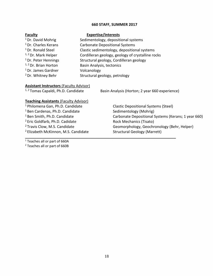
660 STAFF, SUMMER 2017 Faculty Expertise/Interests 1 Dr. David Mohrig Sedimentology, depositional systems 1 Dr. Charles Kerans Carbonate Depositional Systems 1 Dr. Ronald Steel Clastic sedimentology, depositional systems 1, 2 Dr. Mark Helper Cordilleran geology, geology of crystalline rocks 1 Dr. Peter Hennings Structural geology, Cordilleran geology 1, 2 Dr. Brian Horton Basin Analysis, tectonics 1 Dr. James Gardner Volcanology 2 Dr. Whitney Behr Structural geology, petrology Assistant Instructors (Faculty Advisor) 1, 2 Tomas Capaldi, Ph.D. Candidate Basin Analysis (Horton; 2 year 660 experience) Teaching Assistants (Faculty Advisor) 1 Philomena Gan, Ph.D. Candidate Clastic Depositional Systems (Steel) 1 Ben Cardenas, Ph.D. Candidate Sedimentology (Mohrig) 1 Ben Smith, Ph.D. Candidate Carbonate Depositional Systems (Kerans; 1 year 660) 2 Eric Goldfarb, Ph.D. Cadidate Rock Mechanics (Tisato) 2 Travis Clow, M.S. Candidate Geomorphology, Geochronology (Behr, Helper) 2 Elizabeth McKinnon, M.S. Candidate Structural Geology (Marrett) _______________________________________________________________________________ 1 Teaches all or part of 660A 2 Teaches all or part of 660B

19
EQUIPMENT LIST - GEO 660 Required Materials:
Field notebook (e.g., engineer’s field book)
Clipboard (8 1/2 x 11 size) with cover
Geologic hammer
Hand lens (10x)
Small squirt bottle of dilute (approx. 10%) HCl
Grain size card
Six-inch ruler (best is the Post ruler with protractor on it)
Protractor (bring spare rulers & protractors; many students lose several)
Pencils and erasers (again, the number depends on how many you lose)
2 or 3 drafting (mechanical) pencils (recommend Pentel or equivalent 0.5 mm or 0.3 mm lead, hardness F or 3H) and spare leads
Colored pencil set that will keep a point (at least 10 colors); pencils with hard, water-fast lead are preferred
Pencil sharpener or pointer, and/or sandpaper – for colored pencils
Technical pens with fine-line points and black ink (Sizes 00, 0, 1, are desirable)
Tablet of 8 1/2 x 11” tracing paper
Tablet of 10 square to the inch of 8 1/2 x 11” graph paper
Liquid paper (optional)
The textbooks and lab manual from GEO 420K and GEO 428
Calculator
Watch
Carrying bag (shoulder bag or daypack)
Proper field clothes, long pants, long-sleeve shirts, jacket (see note on gear)
Sun screen/block lotion
Hat, wide brim
Hiking boots, broken in (avoid non-lace boots; see note on gear)
Rainwear (it will rain; see note on gear)
Canteen (2 or 3, one-quart water bottles, a Camel-Back or some other water storage container)
Warm sleeping bag and pad** (see note on gear)
Towels, washcloth
Flashlight and/or headlamp
Plate, cup, silverware
Desirable Materials:
Digital Camera
Masking tape
Scotch tape
Tweezers (important for run-ins with cactus)
Insect repellent
Minor first aid kit for bug bites, thorns, blisters (moleskin), etc.
Small pair of binoculars (not necessary but useful for “long-range” mapping)
Whistle (if you are prone to getting lost and have a weak voice)
Safety goggles or other eye protection (see field course policy handout regarding this and hard hats)
Sharpie markers to label rocks
Prohibited Items:

20
Firearms Illegal drugs Consumption of alcoholic beverages in University vehicle

21
Gear for Geo. 660 The equipment list for Geo. 660 contains items that many of you may not own that can be relatively expensive. Below are some ideas on adequate equipment at reasonable prices. A little searching on the web can yield tremendous dividends. Boots Footwear is the single most important item for a field course. Good boots provide traction, protection and support for your feet. Tennis or basketball shoes are not adequate for the latter two reasons, nor are cowboy boots for the former. A wide variety of boot styles are available, from those with low-or high-top nylon/leather uppers, to all-leather boots. Leather boots provide maximum protection, support and, with the proper soles, excellent traction. Most today are designed with backpacking in mind, which requires relatively rigid uppers and maximum padding to provide comfort and support for carrying heavy loads. Once broken-in, a well-made boot of this type is unsurpassed for field use. They are the best at keeping feet dry, provide an important measure of protection from cactus and other thorny plants, and will usually (but not always) outlast a softer boot. The major disadvantage of leather boots is price; a decent pair now costs over $150, with many in the $180-$250 range. Do you need leather boots at this price for 6 weeks of fieldwork? No. A well-made, cheaper pair of “soft” boots can be adequate if: 1) you’re relatively agile and light on your feet; 2) you’re field pack doesn’t weigh more than about 40 lbs.; 3) you’re not prone to kicking cactus. I worked in soft boots for many years and, although they lasted little more than one season, I’ve was very happy with the lowest-priced models of Merrill, Vasque and Asolo boots, which can often be found on sale (or on the web) for less than $80/pair. Well-made pairs by major manufacturers sell at list prices of $70 - $200. Less well made varieties tend to lack side support (foot tends to roll sideways when walking across slopes) and can quickly come apart (soles detach, front rand comes off) after limited use. High-top boots provide ankle support and will keep scree and dirt out when moving down-slope on loose ground. Regardless of the boots you select, you will be much more comfortable if you use well-padded socks with a clean pair of thin sock liners. Sock liners wick moisture from your feet and are easy to wash/rinse at the end of a day. Rain gear A good, well-fitting, waterproof coat is a necessity, not a luxury. We have never experienced a summer where it didn’t rain. Two summers were exceedingly wet, raining nearly every day and for several days on end. We camp and cook outdoors and are in the field every day, rain or shine. Strong winds and colder temperatures often accompany rain in the mountains. Adequate rain gear need not cost 100’s of dollars, but a $5 plastic poncho, which is only marginally better than a plastic trash bag, won’t work in such conditions, nor will a thin nylon shell sprayed with Scotchguard. Lower-priced ($20-50) raincoats and rain pants, which are usually made of plastic- or coated nylon, are adequate and widely available in a variety of styles. The best of the least expensive brands is probably Frogg Toggs. Medium-priced coats (typically $50-100) are somewhat lighter-weight, usually better ventilated, may have an attached hood and are thus more comfortable to work in. They are, however, no more water repellent than lower-priced varieties, sometimes less so. High-priced rainwear is general constructed of one or more “miracle” fabrics; lightweight materials that are touted to “breathe” while also being waterproof. In my opinion (based on several coats, boots, mittens, and a few other items) these fabrics are vastly overrated for the price. Nonetheless, such coats are generally ruggedly constructed, fit well, and typically have many desirable features (multiple pockets, armpit zippers, internal drawstrings, ancillary ventilation, etc.). Again, they are no more waterproof than much lower priced models. Ponchos and umbrellas don’t work well in windy weather. Regardless of what you type of coat you choose be sure it’s large enough to allow for insulating layers underneath. Have a pair of rain pants.
22
Sleeping Bags and Pads This summer, you will spend about 25 nights sleeping on the ground in a tent. Nighttime temperatures can be as low as 30o in June and are commonly 40o-50o. Blankets are only marginally adequate in such conditions; a sleeping bag provides better heat retention and insulation. The enormous price range for sleeping bags reflects differences in insulating materials, weight and construction. At the high end are extremely light, down-filled bags made of waterproof, breathable fabrics that have a comfort range that extends to -30o F. These bags are uncomfortably warm for all but the coldest conditions. At the low end are cotton bags with natural or synthetic fiber insulation, some of questionable construction, which may or may not keep you warm at temperatures below 50o. In between is a very large spectrum of nylon shell, down- or synthetic fiber-filled bags that are more than adequate for summer camping in the US Rockies. Fiber-filled bags are light, dry quickly, are easy to clean, are nearly as warm as down, and pack to a small volume. Like wool, they provide warmth even when wet. Down bags are typically more expensive, slow to dry and nonfunctional when wet. If you are concerned about your sleeping bag keeping you warm, bring a pair of long underwear to sleep in and make sure you have a good sleeping pad. I also use a sleeping bag liner to extend the temperature range of my bag. A sleeping pad or foam mattress provides insulation from cold ground and a measure of comfort. A closed-cell foam or inflatable pad provides the best insulation. A blanket beneath you sleeping bag is better than nothing. Tents The Department no longer supplies tents. Tent prices have come down in recent years and very well made, 2- or 3- person tents are available for $200 or less. In evaluating a tent for this summer, ask yourself the following: Will the tent withstand windy (30-40 mph) conditions? If it has fiberglass poles the answer is likely no. Is it waterproof (or can it be made waterproof) in a sustained, heavy downpour? If the tent fly does not extend most of the way to the ground the answer is no. Do I have all the parts? A waterproof ground cloth (a sheet of heavy mil plastic will do) keeps the floor of your tent from absorbing water and protects against punctures. Clothing You should have clothing that will allow you to live and work comfortably in both cold (40o) and hot (100o+) weather. Cold is best dealt with by wearing layers that can be donned and shed as needed. For maximum comfort your outermost layer should be windproof; rain coats/pants are adequate. Beneath this, a layer that will trap air (sweater, sweat shirt, fleece jacket, down vest, etc.) comes next, underlain by one or more thin layers (T-shirt, long sleeved shirt) that provide additional warmth and wick perspiration from your skin. As much as 70% of your body’s heat loss occurs through your head; if you’re cold put a hat on. A wide brim hat, bandanna, and sunblock are essential for working in the deserts of western US. Finally, you will be traveling or working outdoors nearly every day of the 6 weeks. You will load and unload your gear, along with ice chests, cook boxes, tarps, etc., many, many times along the way. It is to your and everyone else’s benefit to travel light. Examine every piece of clothing you pack critically; do you really need it? Keep in mind that there will be opportunities to do laundry at most places we visit and we will not be anywhere that requires anything more than field clothing.

23
Jackson School of Geosciences Department of Geological Sciences Field Trip and Field Course Policies
The Department of Geological Sciences conducts numerous field activities (field trips, field
geology
courses, and field research). Because students are exposed to a variety of situations and
experiences that are different from those found in the classroom, special rules of conduct are
necessary. Traveling and field work involves hazards and risks, so each person must exercise
care to avoid personal injury to others. Examples of dangers specific to field work are the use of
geologic picks, poisonous snakes, tick bites, toxic plants, falling, and slippery rocks encountered
when hiking on steep slopes or crossing streams. Other dangers, as well as damage to property,
may be created by carelessness. The Department has access to certain private properties and use
of private facilities whose future availability will depend upon proper consideration for these
resources by everyone. Students who abuse University or personal property during a field trip, or
who jeopardize the health and safety of other people, will be required to leave the field trip
immediately. These persons will be subject to appropriate academic evaluation and possible
disciplinary action by the Office of the Dean of Students.
The Department has the following rules and recommendations which apply to field activities. 1. Liability and Waiver. The University requires all students to sign a liability release form (accompanying form).
This form must be signed and returned before a student is allowed to participate in field activities.
2. Medical Care. A medical form must be filled out by all students. Any student who has medical problems (e.g.
asthma, diabetes, metabolic disorders, allergies, trick knees) should inform the field trip leader or supervising
professor. If you require special medications, it is your responsibility to insure that they are available when
needed. Field activities are sometimes in very remote areas, and immediate medical assistance is not possible.
3. Health Insurance. Every student taking a field course must have medical insurance. Student health insurance is
available at minimal cost through the Student Health Center (471-4955). Students taking field trips as part of
normal classes who do not have health insurance will be provided with insurance for the field trips only.
4. Clothing and protective cover. Wear suitable clothes. We recommend wearing a hat, long pants, and good
hiking boots in some areas. These help prevent sunstroke, insect bites, and bad encounters with cacti or thorny
shrubs. You may want to bring insect repellent, and we also suggest the use of sunscreen. Consider significant
possibilities of rain or cold weather.
5. General field hazards. Insects, poisonous snakes, and toxic plants may be found on any field trip or course.
Wearing suitable clothing and boots helps reduce these hazards. Remember to check yourself for ticks which
can transmit diseases such as Rocky Mountain spotted fever, Lyme disease, etc. Ticks should be removed
immediately; be sure to remove the body with head intact. Do not use a match to kill the tick first. Watch for,
don't play with, and avoid snakes. Five students on Department trips have been bitten by rattlers since World
War II; try not to be the sixth. If you are allergic to such things as bee stings, you must bring appropriate
medication. A few other common sense rules: stay out of the water if you can't swim; stay out of
thunderstorms, particularly at high elevations, and out of flashflood-prone areas in any rain. Some field areas
have steep cliffs that you are not required to and should not climb; use common sense and follow your
instructor's advice in such areas.
6. Head and eye protection. We recommend eye protection when using, or around someone using, a geologic
pick, hammer, or other tools. Hard hats should be used in mines, quarries, steep road cuts, or other areas where
rock falls or blows to the head could occur; some sites may require these protective devices. Safety glasses and
hard hats can be checked out from the Department storeroom.
7. Firearms. Possession of firearms or facsimiles at any time during any field course or field trip is forbidden.
8. Drugs and alcohol. Use or possession of illegal drugs at any time is forbidden. Alcoholic beverages may NOT
be consumed at any time while traveling in a University vehicle.
9. Department equipment. Take care of Department property. Our equipment normally gets hard use and current
budgets are tight, so treat it as you would your own.
You have previously read and agreed by signature to follow the Field Trip/Field Course Policies for departmental field activities given above. Please keep them in mind this summer.
25
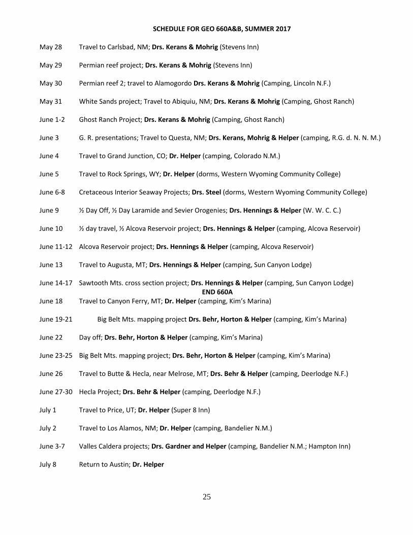
SCHEDULE FOR GEO 660A&B, SUMMER 2017
May 28 Travel to Carlsbad, NM; Drs. Kerans & Mohrig (Stevens Inn) May 29 Permian reef project; Drs. Kerans & Mohrig (Stevens Inn) May 30 Permian reef 2; travel to Alamogordo Drs. Kerans & Mohrig (Camping, Lincoln N.F.) May 31 White Sands project; Travel to Abiquiu, NM; Drs. Kerans & Mohrig (Camping, Ghost Ranch) June 1-2 Ghost Ranch Project; Drs. Kerans & Mohrig (Camping, Ghost Ranch)
June 3 G. R. presentations; Travel to Questa, NM; Drs. Kerans, Mohrig & Helper (camping, R.G. d. N. N. M.) June 4 Travel to Grand Junction, CO; Dr. Helper (camping, Colorado N.M.) June 5 Travel to Rock Springs, WY; Dr. Helper (dorms, Western Wyoming Community College) June 6-8 Cretaceous Interior Seaway Projects; Drs. Steel (dorms, Western Wyoming Community College) June 9 ½ Day Off, ½ Day Laramide and Sevier Orogenies; Drs. Hennings & Helper (W. W. C. C.) June 10 ½ day travel, ½ Alcova Reservoir project; Drs. Hennings & Helper (camping, Alcova Reservoir) June 11-12 Alcova Reservoir project; Drs. Hennings & Helper (camping, Alcova Reservoir) June 13 Travel to Augusta, MT; Drs. Hennings & Helper (camping, Sun Canyon Lodge) June 14-17 Sawtooth Mts. cross section project; Drs. Hennings & Helper (camping, Sun Canyon Lodge)
END 660A June 18 Travel to Canyon Ferry, MT; Dr. Helper (camping, Kim’s Marina) June 19-21 Big Belt Mts. mapping project Drs. Behr, Horton & Helper (camping, Kim’s Marina) June 22 Day off; Drs. Behr, Horton & Helper (camping, Kim’s Marina) June 23-25 Big Belt Mts. mapping project; Drs. Behr, Horton & Helper (camping, Kim’s Marina) June 26 Travel to Butte & Hecla, near Melrose, MT; Drs. Behr & Helper (camping, Deerlodge N.F.)
June 27-30 Hecla Project; Drs. Behr & Helper (camping, Deerlodge N.F.) July 1 Travel to Price, UT; Dr. Helper (Super 8 Inn) July 2 Travel to Los Alamos, NM; Dr. Helper (camping, Bandelier N.M.) June 3-7 Valles Caldera projects; Drs. Gardner and Helper (camping, Bandelier N.M.; Hampton Inn) July 8 Return to Austin; Dr. Helper

26
MONEY FOR MEALS
All meals while camping and all lunches, except on travel days, will be provided.
All hotels during the trip will provide at least a continental breakfast (bread, pastry, juice, coffee) and some may have hot food. If you eat a hardy breakfast you may want to purchase addition breakfast food – it will not otherwise be provided.
You will need money to purchase lunch and dinner during some hotel stays. These days are May 28, 29; July 5-8 (6 total days).
Ice chest/refrigerators will be available to store food/medicine during hotel stays. You will be able to make a lunch from food we purchase for this purpose before going into the field, provided you are leave yourself time to do so before departure. All lunch food is put away at 7:45 AM.
27
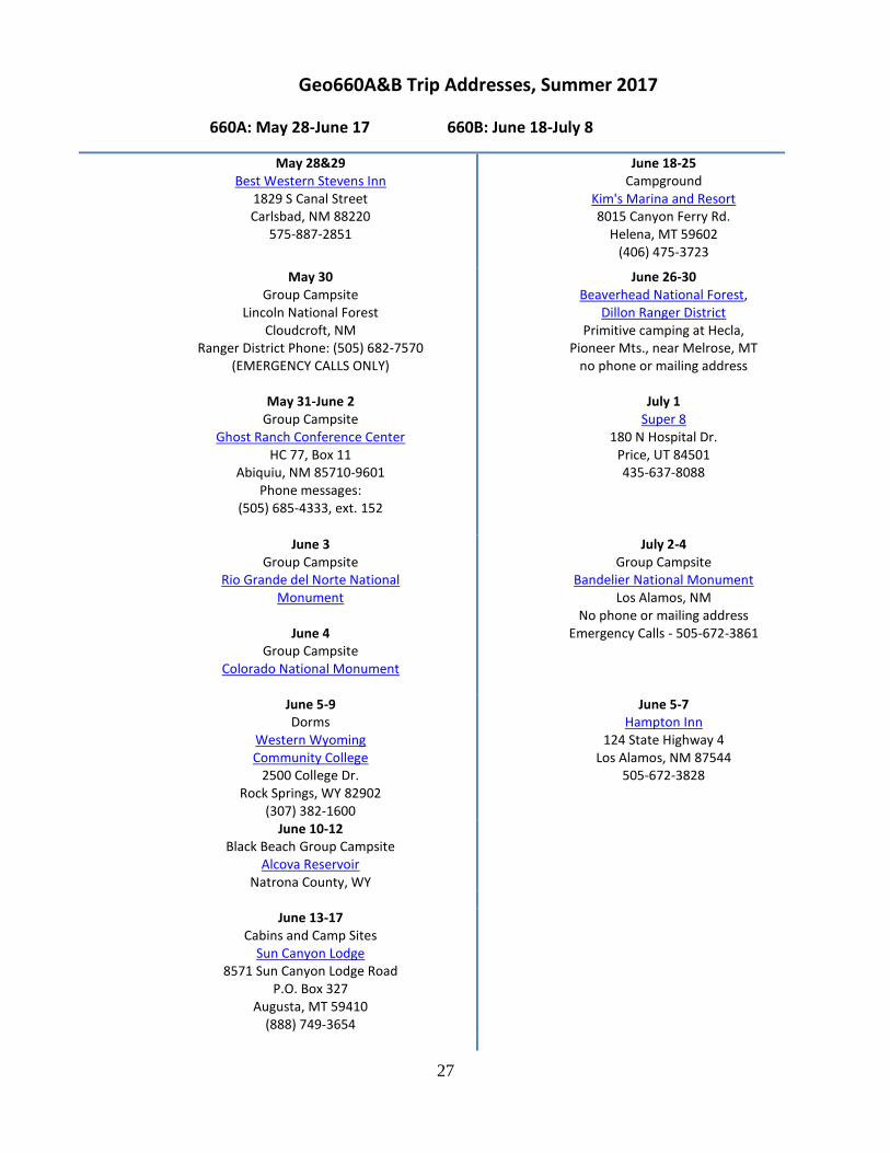
Geo660A&B Trip Addresses, Summer 2017
660A: May 28-June 17 660B: June 18-July 8
May 28&29 Best Western Stevens Inn
1829 S Canal Street Carlsbad, NM 88220
575-887-2851
June 18-25 Campground
Kim's Marina and Resort 8015 Canyon Ferry Rd.
Helena, MT 59602 (406) 475-3723
May 30 Group Campsite
Lincoln National Forest Cloudcroft, NM
Ranger District Phone: (505) 682-7570 (EMERGENCY CALLS ONLY)
June 26-30 Beaverhead National Forest,
Dillon Ranger District Primitive camping at Hecla,
Pioneer Mts., near Melrose, MT no phone or mailing address
May 31-June 2
Group Campsite Ghost Ranch Conference Center
HC 77, Box 11 Abiquiu, NM 85710-9601
Phone messages: (505) 685-4333, ext. 152
July 1 Super 8
180 N Hospital Dr. Price, UT 84501 435-637-8088
June 3 Group Campsite
Rio Grande del Norte National Monument
June 4
Group Campsite Colorado National Monument
July 2-4 Group Campsite
Bandelier National Monument Los Alamos, NM
No phone or mailing address Emergency Calls - 505-672-3861
June 5-9 Dorms
Western Wyoming Community College
2500 College Dr. Rock Springs, WY 82902
(307) 382-1600
June 5-7 Hampton Inn
124 State Highway 4 Los Alamos, NM 87544
505-672-3828
June 10-12 Black Beach Group Campsite
Alcova Reservoir Natrona County, WY
June 13-17
Cabins and Camp Sites Sun Canyon Lodge
8571 Sun Canyon Lodge Road P.O. Box 327
Augusta, MT 59410 (888) 749-3654

28
COURSE DESCRIPTION, GEO 660A&B, SUMMER 2017
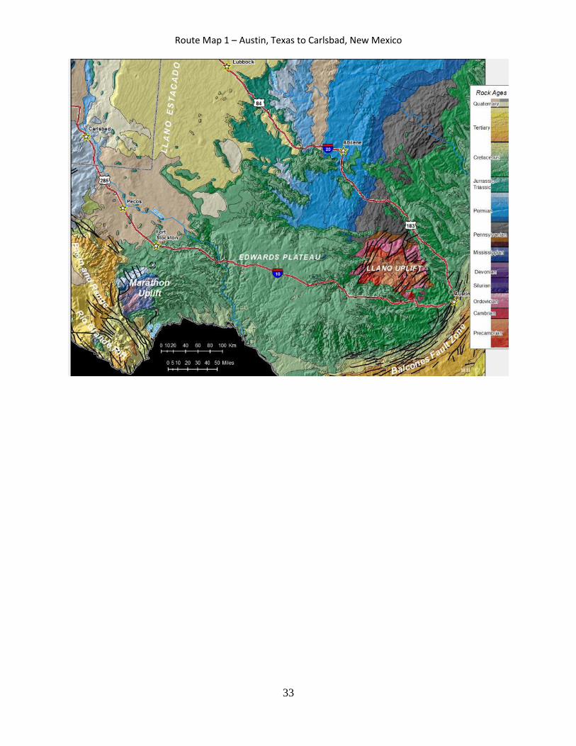
May 28-30 Permian Basin of West Texas and New Mexico – Drs. Kerans and Mohrig The Permian Basin of West Texas and New Mexico is one of the most famous geological sites in the world. Tertiary faulting and uplift has caused the exposure of a shelf-to-basin setting that contains both carbonate and terrigenous sediments. Introduction to Guadalupe Mountains and Permian Basin Stratigraphic Setting/ Permian Reef Geology Trail, McKittrick Canyon – Drs. Kerans and Mohrig There is perhaps no better setting to begin your exploration of the field observation and interpretation of depositional processes than the Guadalupe Mountains. Dramatic 2-3000 ft high walls of carbonate and clastic shelf, slope and basin deposits are laid out in spectacular vistas. We will present the stratigraphic setting, and then sketch and interpret several of these major walls in terms of stratal geometric relationships and depositional processes. An all-day hike up the 2000 vertical feet of the Permian Reef Geology Trail reveals the depositional facies and stratal geometries of a major reef-rimmed carbonate platform. We will use the Permian Reef Geology Trail guide as background material but will formulate our own model of a representative depositional profile from observations made along the trail. May 31, Sacramento Mts. and White Sands National Monument, near Alamogordo, NM – Drs. Kerans and Mohrig The Sacramento Mountains, together with the Guadalupe and Franklin Mountains, comprise the outcrop trilogy used by industry and academic groups since the 60’s to illustrate different styles of carbonate facies and reef styles. Exceptional exposures of unique Pennsylvanian phylloid algal mounds in Dry Canyon illustrate both a unique style of carbonate deposition and the distinct depositional patterns of an icehouse system, with repeated large amplitude swings in sea-level. These exposures, plus the Mississippian buildups of the Lake Valley Group provide a broad spectrum of carbonate and mixed systems. Reconstruction of environmental conditions associated with deposition of the Holder Formation, a Virgilian (Upper Pennsylvanian) mixed siliciclastic–carbonate sequence is the theme of one project here. The White Sands gypsum dune field visited provides an ideal setting for examining dune geometries and aeolian processes and is the focus of another exercise. The afternoon of this day is spent traveling to Ghost Ranch Conference Center on the Colorado Plateau. The drive north takes us across a young lava flow (the Carrizzo flow) and up the axis of the Rio Grande rift to Albuquerque. From Albuquerque, we proceed north and northwest within the rift, skirting Santa Fe as we make our way past the giant Valles Caldera (we return here for the last project of 660B), which sits along the western edge of the rift at the north edge of the Espanola Basin, one of a series of rift sub-basins. June 1-3 Aeolinites and evaporites – sedimentology and stratigraphy of the Jurassic Morrison, Todilto and Entrada Formations – Drs. Mohrig and Kerans Here we measure, describe and interpret the stratigraphic and depositional contrasts between aeolian dune sandstone of the Entrada Formation and overlying gypsum beds of the Todilto Formation, as exposed in the walls of the canyons surrounding our campground. These ancient deposits are contrasted with the modern dunes of White Sands N.M. We move the afternoon of June 3 to an overnight stop at the Rio Grande del Norte National Monument near Questa, New Mexico. The Rio
29
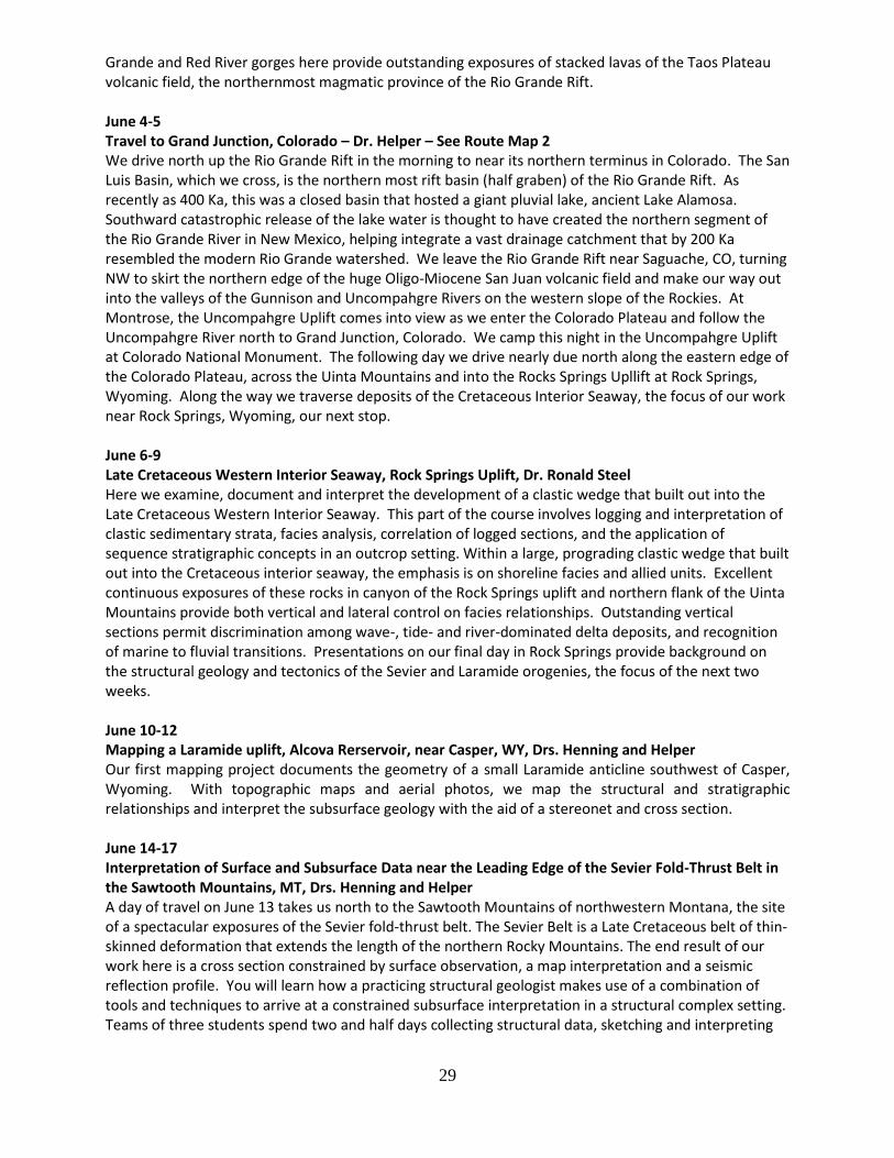
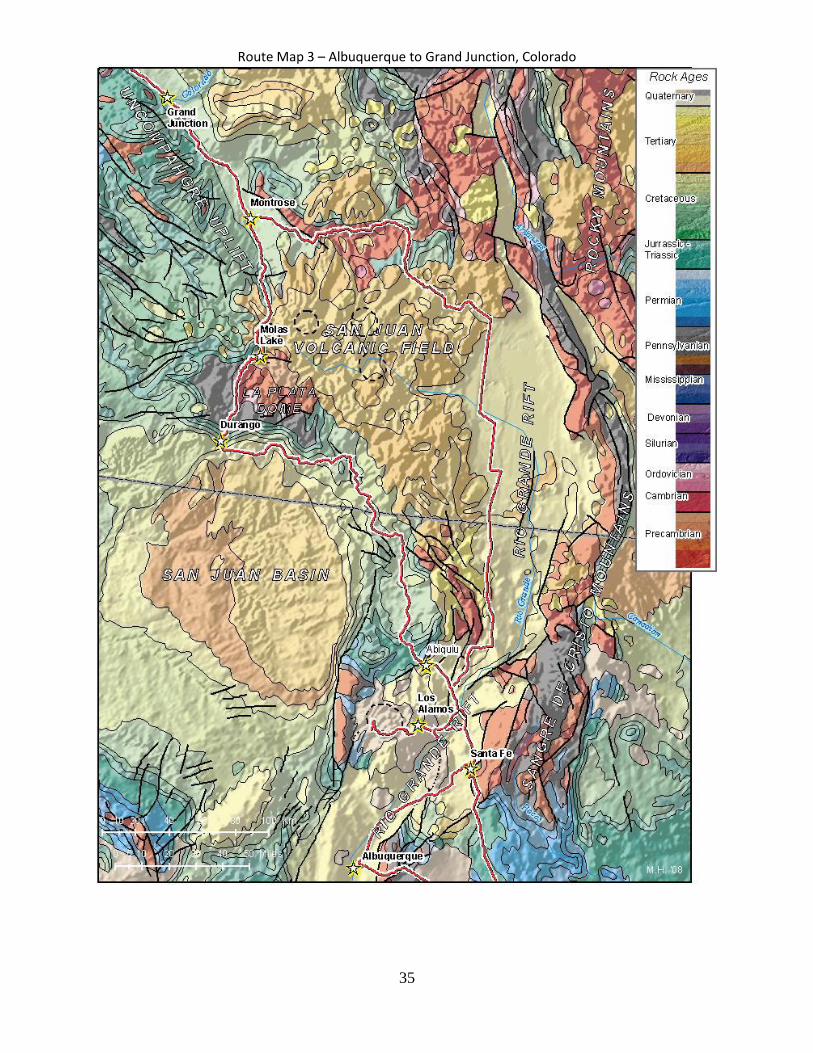
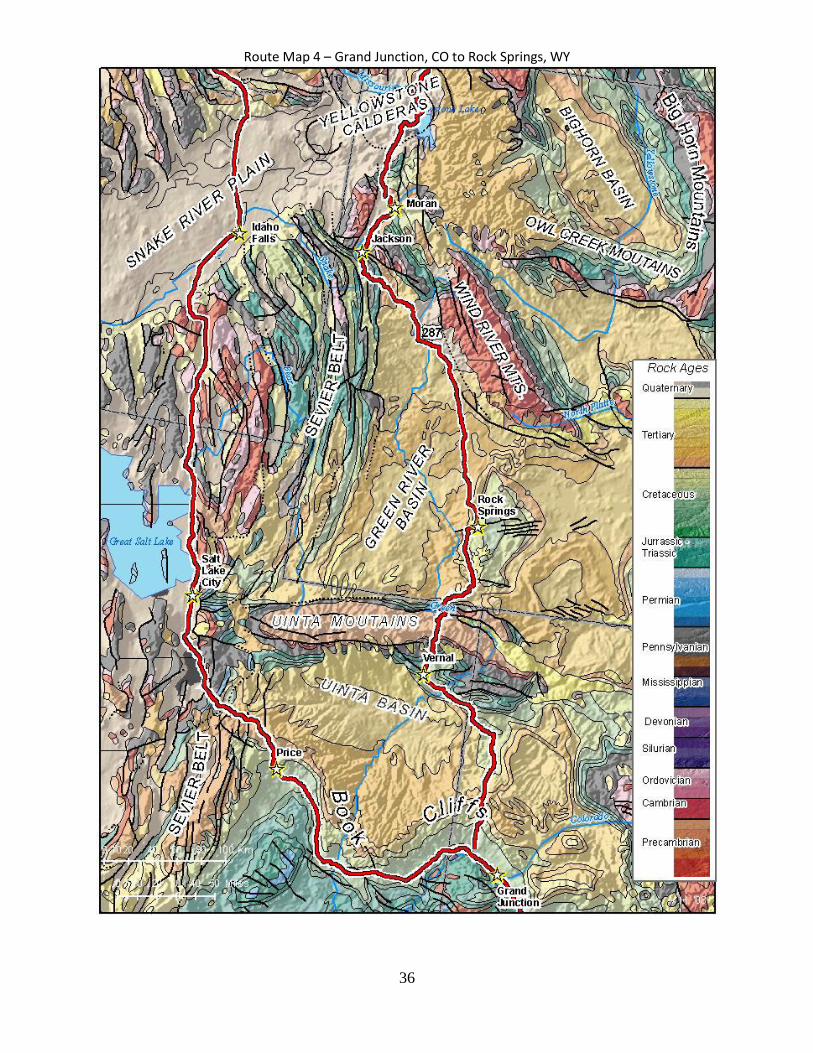
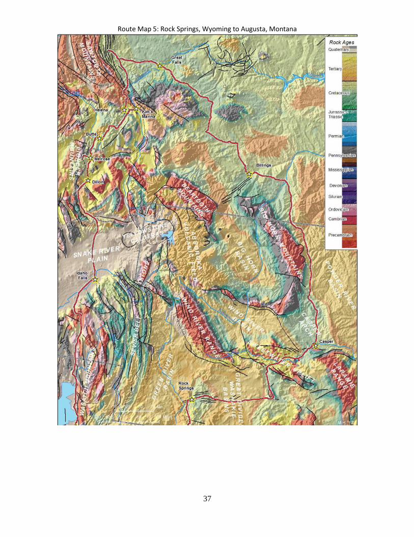
Grande and Red River gorges here provide outstanding exposures of stacked lavas of the Taos Plateau volcanic field, the northernmost magmatic province of the Rio Grande Rift. June 4-5 Travel to Grand Junction, Colorado – Dr. Helper – See Route Map 2 We drive north up the Rio Grande Rift in the morning to near its northern terminus in Colorado. The San Luis Basin, which we cross, is the northern most rift basin (half graben) of the Rio Grande Rift. As recently as 400 Ka, this was a closed basin that hosted a giant pluvial lake, ancient Lake Alamosa. Southward catastrophic release of the lake water is thought to have created the northern segment of the Rio Grande River in New Mexico, helping integrate a vast drainage catchment that by 200 Ka resembled the modern Rio Grande watershed. We leave the Rio Grande Rift near Saguache, CO, turning NW to skirt the northern edge of the huge Oligo-Miocene San Juan volcanic field and make our way out into the valleys of the Gunnison and Uncompahgre Rivers on the western slope of the Rockies. At Montrose, the Uncompahgre Uplift comes into view as we enter the Colorado Plateau and follow the Uncompahgre River north to Grand Junction, Colorado. We camp this night in the Uncompahgre Uplift at Colorado National Monument. The following day we drive nearly due north along the eastern edge of the Colorado Plateau, across the Uinta Mountains and into the Rocks Springs Upllift at Rock Springs, Wyoming. Along the way we traverse deposits of the Cretaceous Interior Seaway, the focus of our work near Rock Springs, Wyoming, our next stop. June 6-9 Late Cretaceous Western Interior Seaway, Rock Springs Uplift, Dr. Ronald Steel Here we examine, document and interpret the development of a clastic wedge that built out into the Late Cretaceous Western Interior Seaway. This part of the course involves logging and interpretation of clastic sedimentary strata, facies analysis, correlation of logged sections, and the application of sequence stratigraphic concepts in an outcrop setting. Within a large, prograding clastic wedge that built out into the Cretaceous interior seaway, the emphasis is on shoreline facies and allied units. Excellent continuous exposures of these rocks in canyon of the Rock Springs uplift and northern flank of the Uinta Mountains provide both vertical and lateral control on facies relationships. Outstanding vertical sections permit discrimination among wave-, tide- and river-dominated delta deposits, and recognition of marine to fluvial transitions. Presentations on our final day in Rock Springs provide background on the structural geology and tectonics of the Sevier and Laramide orogenies, the focus of the next two weeks. June 10-12 Mapping a Laramide uplift, Alcova Rerservoir, near Casper, WY, Drs. Henning and Helper Our first mapping project documents the geometry of a small Laramide anticline southwest of Casper, Wyoming. With topographic maps and aerial photos, we map the structural and stratigraphic relationships and interpret the subsurface geology with the aid of a stereonet and cross section. June 14-17 Interpretation of Surface and Subsurface Data near the Leading Edge of the Sevier Fold-Thrust Belt in the Sawtooth Mountains, MT, Drs. Henning and Helper A day of travel on June 13 takes us north to the Sawtooth Mountains of northwestern Montana, the site of a spectacular exposures of the Sevier fold-thrust belt. The Sevier Belt is a Late Cretaceous belt of thin-skinned deformation that extends the length of the northern Rocky Mountains. The end result of our work here is a cross section constrained by surface observation, a map interpretation and a seismic reflection profile. You will learn how a practicing structural geologist makes use of a combination of tools and techniques to arrive at a constrained subsurface interpretation in a structural complex setting. Teams of three students spend two and half days collecting structural data, sketching and interpreting

30
map relationships, and a day and a half interpreting a seismic section, synthesizing data and compiling a cross section.
End of Geo660A/Beginning of GEO660B June 19-25 Structural geology of a fold-dominated portion of the Sevier Belt - Drs. Helper, Behr and Horton After traveling south on June 18 to Helena, Montana, buying groceries and establishing a camp at the foot of the Big Belt Mountains, we begin a week of mapping a fold-dominated portion of the Sevier Belt. Mapping, cross-section construction and description of two small area within the Big Belt Mountains provides a contrast with the thrust-dominated deformation and structural styles of the previous week. Mapping projects are separated by a Day Off. Both three-day projects follow a similar approach:
Introduction to setting and stratigraphy o Compile a stratigraphic column of map units, recon. the field area, begin mapping
Continued mapping o Begin constructing cross section and stereonets
Finish mapping o Turn in map, cross section and stereonets
June 26 Travel and ore deposits Introduction: Field trip to Butte, Montana; travel to Hecla, near Melrose - Drs. Helper & Behr – See Route Map 5 We travel south and west to Butte, MT to see what remains of "the richest hill on earth". Discussions on giant porphyry copper deposits, EPA superfund sites and mining in the west. After buying supplies, we drive south into the Pioneer Mountains, where we establish a camp near the ghost towns of Lion City and Hecla, once the center of the richest silver mining district in Montana. With published maps and reports already in hand, we will spend four days documenting and unraveling field relationships among deformation, plutonism, metamorphism and mineralization within facies equivalents of the same strata mapped in the previous two projects. June 27-30 Hecla Project: Ore deposit geology and geologic processes - Drs. Helper & Behr This project integrates different geological disciplines to unravel the geological history of this late-1800’s silver-zinc mining district. Field data will be collected over a period of four days to understand the sedimentary, structural, metamorphic, magmatic and hydrothermal history of this area and produce a concise report that synthesizes this information. In addition to introducing new concepts (for 660) in metamorphic and ore geology, this exercise offers a unique chance to integrate different types of data to understand the geological history of an area – a common exercise for any earth scientist. July 1 Travel South to Price, UT, Dr. Helper – See Route Maps 5 and 4 below
Lunch: Flood basalts at Snake River Plain visitor’s center
Afternoon: Great Salt Lake, Wasatch Mountains and Wasatch Mountain Fault July 2 Travel from Price, UT to Los Alamos, NM, Dr. Helper – See Route Maps 4 and 3 below
o Lunch at Arches National Monument o Stop on western edge of Taos Plateau to view and discuss Rio Grande rift and rift volcanism

31
July 3-7 Geology and Volcanology of a Supervolcano – the Valles Caldera, Jemez Mountains, New Mexico – Drs. Gardner and Helper – See Route Map 2 and 3 The Valles caldera of the Jemez Mountains is the classic locality for understanding the nature of large-volume caldera eruptions. Exception preservation and outstanding exposures of Pleistocene eruptive products (ash flow and air fall tuffs, lava flows, lava domes) provide an unparalleled opportunity to examine, map and describe the hallmarks of these enormous, explosive eruptions. After a full day drive from Price, UT, we arrive in Los Alamos, NM to establish a camp at Bandelier National Monument, the site of native American cliff and ground dwellings intimately linked to the geology of the Bandelier Tuff, one eruptive product of the caldera. Our first day is devoted to a field trip that examines the products and processes associated with caldera eruptions. Day 2) begins with a visit to the main canyon of the Monument, Frijoles Canyon, where we map and describe a beautifully exposed Maar deposit, and examine other aspects of pre-caldera and caldera forming volcanism. We also get a glimpse of the pre-caldera topography, as exposed in the canyon walls. Days 3-6 are devoted to learning to recognize, interpret and map the intrusive and eruptive products of calderas during two, single day mapping exercises. July 8 Travel to Austin – Dr. Helper – See Route Maps 2 and 1 An early departure and very long drive this day once again takes us across the Rio Grande Rift to Santa Fe, retracing from there much of the route of Day 1 across the eastern rift shoulder, the high plains of the Llano Estacado and the Edwards Plateau as we near Austin. It’s been 5700 miles of geologic immersion, with memories of experience to last a lifetime - what a class, what a trip!
32
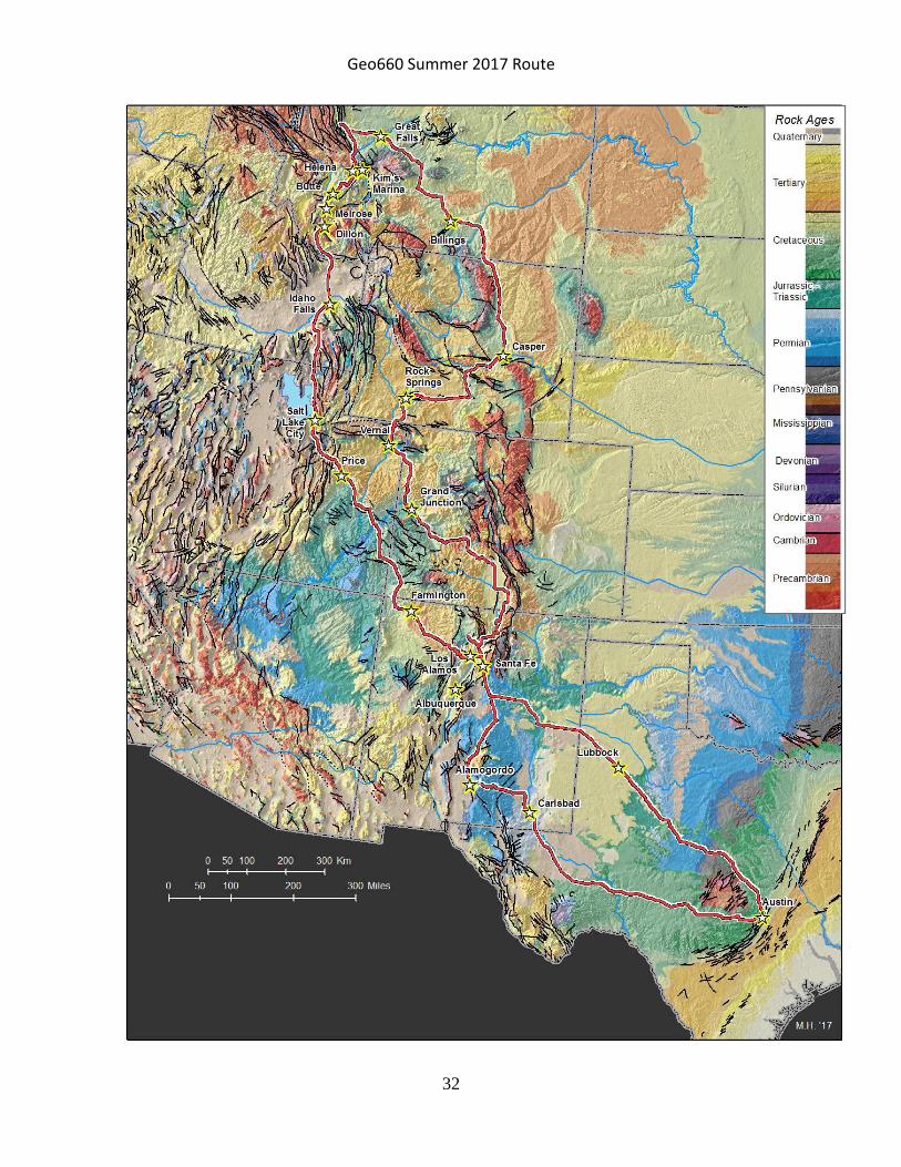
Geo660 Summer 2017 Route
33
Route Map 1 – Austin, Texas to Carlsbad, New Mexico

34
Route Map 2 – Carlsbad to Ghost Ranch, New Mexico
35
Route Map 3 – Albuquerque to Grand Junction, Colorado
36
Route Map 4 – Grand Junction, CO to Rock Springs, WY
37
Route Map 5: Rock Springs, Wyoming to Augusta, Montana
38
Being Academically Prepared
Sedimentary Geology
Below are listed some general aspects of sedimentary geology that you will be expected to have mastered by the time you leave for Geo 660. All of this material was covered in Geo 416M and Geo 420K. The best sources for your review are your notes, the text, and the web sites for these courses. 1. Classification of rocks and sediment by texture
You must be able to classify terrigenous sediments and rocks by texture (e.g., poorly sorted, immature, fine-grained sandstone). This means that you must be able to identify the mean grain size, estimate the grain sorting, recognize the four stages of textural maturity, and recognize grain shape and roundness. You should be able to tell if the sorting reflects a unimodal, bimodal or polymodal grain distribution. Impact scars on pebbles and larger grains are important to identify. Rock color also reflects important aspects of the rock. You must have an understanding of the factors that control these sediment/rock characteristics. For sandstones and conglomerates be able to estimate the abundance of framework grains, matrix, cement, and porosity using your hand lens.
You must be able to distinguish those rock aspects that are depositional in nature from those that result from weathering. For example, weathering commonly results in the oxidation of pyrite and other ferrous minerals, differential dissolution of minerals, hydration, oxidation, and case-hardening of joints. Precipitation of travertine crusts and soluble white salt crusts (efflorescence), as well as Liesegang bands, are post-depositional products. In addition, it is usually possible on outcrop to recognize basic lithology (e.g., sandstone, limestone, shale) by weathering habit.
Be able to classify carbonate rocks according to the Dunham classification, including identification of major grain types. Know the major taxonomic groups of invertebrate fossils and their environmental significance. Know the marine evaporite mineral sequence. 2. Classification of rocks and sediment by mineralogy
Be able to classify sediment and rocks by mineralogy (e.g., arkose). For sandstones be able to estimate the type of common cements (quartz, calcite, dolomite, siderite, iron oxides, kaolinite), the abundance of QFR components, and clan name using the Folk classification. Understand the relationship between mineralogy, source area, and other controls such as climate, tectonism and nature of transport. 3. Sedimentary structures
You must be able to identify sedimentary structures and understand under what conditions they form. Be able to identify common fossils, know their age ranges, and environmental significance. Below are listed some common sedimentary structures and other features of sedimentary rocks. You should be able to recognize these, understand how they form, and interpret their genetic significance.

39
Laminations Breccia Wind-ripple laminations Paleokarst Trough cross-strata Evaporite molds Tabular cross-strata Inter vs. intraparticle porosity Current ripple and climbing ripple cross-strata Boundstone Wave ripple cross-strata Geopetals Hummocky cross-strata Fenestral fabric Textural mottled bedding Structureless (massive) bedding Graded and reverse graded bedding Contorted bedding Nodular bedding Flaser and lenticular bedding Herringbone cross-strata Scour-and-fill structures Channel walls and channel-fills Cryptalgal laminations, stromatolites (laterally linked and stacked hemispheres) Bouma sequence Wave and current ripple marks Trace fossils: burrows, tracks, and trails Flute casts, groove casts, load casts
Parting lineation Mud cracks Stylolites Liesegang bands Chert and other nodules, calcite-cemented concretions (and other types) Cone-in-cone structure Adhesion structures
4. Depositional and diagenetic environments and processes
You must be able to make a basic interpretation of environment of deposition (e.g., deep-sea turbidite sequences, meandering fluvial channel). You should be able to determine whether the seafloor was well oxygenated, suboxic, anoxic. Clues are TOC (reflected in rock color), presence of absence of trace fossils, abundance of pyrite, etc. Most information is derived from the larger-scale geometry of the strata. You should always scan an outcrop for the continuity of beds, the overall strata arrangement, faults, channel structures, and vertical trends before studying the rock up close. For carbonate and evaporite environments, review the shelf-to-basin facies tract, the environmental factors important for carbonate/evaporite production, the different styles of carbonate shelf architecture as a function of changes in sea level, climate, time in geologic history. Review the principal mechanisms proposed for (1) changing sea level, (2) dolomitization, (3) subaerial and subaqueous evaporite deposition, (4) cyclic sediment deposition.

40
5. Field methods
You must be able to perform basic field procedures including (1) measuring a section with a staff and Brunton compass or similar instrument, (2) identifying textures and mineralogies with a hand lens, and (3) using a Brunton compass or similar instrument to measure bedding and foreset orientations, (4) operate a hand-held GPS instrument. 6. Data presentation
You must be able to display geological information in various formats including (1) vertical sections, (2) scaled field sketches, (3) cross-sections, (4) neatly drafted maps, (5) stereonets. 7. Basin-scale processes
You must have a basic understanding of (1) tectonic basin types, (2) the types of environments associated with these, and (3) the types of sediments characteristic of the different types of basins and source areas. 8. Global-scale processes
You must have a basic understanding of the depositional architectures and their scales as a function of cycles of sea level, climate and tectonism. Know the general history of Earth change (e.g., greenhouse/icehouse periods, first-order sea-level curve), and the basics of higher order processes such as orbital forcing of Earth’s climate. Structural Geology & Mapping
The topics and the skills outlined below were covered in GEO428, 426P, 420K, 416K and 401/303, particularly in labs and/or field trip exercises. Notes, texts, old labs and web sites for these courses are particular valuable resources for review.
1) Be able to read a topographic map, construct a topographic profile along a line of section, and have the ability to accurately locate yourself with a topographic map.
2) Have a good understanding of strike lines (structure contours), 3-point problems, the rule of V's,
and how these are manifest on geologic maps by unit contacts, fault traces, fold axial traces. 3) Be able to correctly use a Brunton compass to measure the attitudes of linear and planar
features. 4) Be able to construct stereographic projections of the attitudes of lines and planes, and
determine a fold axis from attitude measurements of folded layers.
5) Be able to appropriately label maps and cross sections (and where these items belong on a
finished product): title, author, date, north arrow, scale bar, contour interval, stratigraphic symbols, explanation of symbols, location of cross section; endpoints of cross section, orientation of cross section, vertical scale, and vertical exaggeration.
6) Be able to draw a structural cross section; know how to project data from a map into the plane
of a cross section.

41
7) Know fold terminology and map symbols: fold axis, axial surface, hinge line, axial trace, plunge,
fold limbs, cylindrical, overturned vs. upright, parallel vs. non-parallel, angular vs. curved. 8) Know fault terminology and map symbols: thrust, normal, strike slip, footwall, hanging wall,
displacement, dip and strike separation, fault tip, fault ramp, detachment, listric, thin-skinned vs. thick-skinned, releasing and restraining bends.
9) Be able to interpret a geologic map, including relative ages from superpositional or cross-cutting
relationships, dip directions from map patterns, anticlines vs. synclines and directions of plunge, axial trace symbols, up vs. down sides of faults from map patterns.
Igneous Geology
1) Know how to classify igneous rocks using compositional criteria (intrusive rocks: granite, granodiorite, gabbro, peridotite; extrusive rocks: rhyolite, andesite, dacite, basalt) and textural criteria (tuff, welded tuff, vitrophyre, etc.), and apply appropriate adjectives (porphyritic, aphanitic, phaneritic, etc.).
2) Be able to identify common minerals in igneous rocks with a hand lens. These include, but are
not limited to, quartz, plagioclase, k-feldspar, biotite, muscovite, clinopyroxene, amphibole (hornblende) and olivine.
3) Have an appreciation for the geological settings in which different igneous rocks might be found.
Metamorphic Geology
1) Know how to classify metamorphic rocks (slate, phyllite, schist, gneiss, hornfels) and apply appropriate adjectives (granoblastic, porphyroblastic, foliated, etc.).
2) Be able to identify common metamorphic minerals with a hand lens. These include, but are not
limited to: i) minerals common to most metamorphic rocks: quartz, plagioclase, k-feldspar, biotite, muscovite, chlorite, ii) pelites: garnet, aluminosilicates (andalusite, kyanite, sillimanite), staurolite, iii) metabasites: clinopyroxene, orthopyroxene, amphibole (hornblende, tremolite/actinolite), and iv) metacalcsilicates/metacarbonates: calcite, dolomite, talc, tremolite, wollastonite, diopside.
3) Have an understanding of the concepts of metamorphic facies, P-T and T-X grids and isograds, including an appreciation of the dependence of mineral assemblages on rock composition, temperature, pressure and fluid composition/availability.
4) Understand the relationship of fabrics defined by metamorphic minerals to minor and major folds and faults/shear zones.
5) Know metamorphic index minerals for pelitic and mafic rocks.