sustainability appraisal and strategic environmental ... · pdf filesustainability appraisal...
TRANSCRIPT

1
June 2015
BALCOMBE NEIGHBOURHOOD PLAN
Sustainability Appraisal and Strategic
Environmental Assessment
Published by Balcombe Parish Council under the
Neighbourhood Planning (General) Regulations 2012 and in
accordance with EU Directive 2001/42
June 2015
Contents
Non-technical summary
1. Introduction
2. Methodology
3. Policy Context
4. Parish Characteristics and Issues
5. Key Sustainability Issues
6. Objectives of the Sustainability Appraisal
7. Sustainability Objectives
8. Assessment of Neighbourhood Plan Policies
Appendix A: Summary of Plans and Programmes
Appendix B: Summary of Responses from Statutory Consultees
Appendix C: Areas of SSSI, SSNI and the Flood Zone
Appendix D: Village Conservation Area and Ancient Woodland
Appendix E: Individual Site Assessments (June 2014)
Appendix F: Shortlisted Site Assessments following Community Consultation

2
June 2015
Non-Technical Summary Balcombe Parish Council is preparing a Neighbourhood Plan in accordance with the Neighbourhood
Planning (General) Regulations 2012. The whole of the parish area has been designated a
Neighbourhood Area for this purpose by Mid Sussex District Council.
A Sustainability Appraisal, as defined by the Planning and Compulsory Purchase Act 2004, aims to
predict and assess the social, environmental and economic effects that are likely to arise from the
adoption of plans or programmes, in order to ensure that the strategies, policies and plans within
these contribute to and promote sustainable development. Although not a requirement of the
Neighbourhood Planning (General) Regulations 2012, an Appraisal provides a means of
demonstrating the Plan will promote sustainable development.
A Strategic Environmental Assessment, as defined by European Directive 2001/42, aims to predict
and assess the environmental effects that are likely to arise from plans, policies and strategies. It is a
process for assessing and mitigating the negative environmental impacts of specific plans and
programmes. In which case, Neighbourhood Plans may be required to undertake Strategic
Environmental Assessment.
The Strategic Environmental Assessment Screening Opinion published by Mid Sussex District Council
in May 2013 requires all Plans in its area that are intending to allocate land for housing or
employment use to undertake an Strategic Environmental Assessment.
In the UK, the Strategic Environmental Assessment process has been incorporated into the
Sustainability Appraisal process. Therefore where this report refers to the Sustainability Appraisal, it
can be assumed this also means the Strategic Environmental Assessment. It therefore aims to
predict the effects of the policies and proposals of the Balcombe Neighbourhood Plan and has been
used to inform its production to ensure that the policies promote sustainable development.
The Sustainability Appraisal Report
The Balcombe Neighbourhood Plan sets out a vision for how Balcombe parish will evolve and a
delivery plan for how that will be achieved. The Neighbourhood Plan covers the period from 2015 to
2035. It is in general conformity with the strategic policies of the District Plan and with the National
Planning Policy Framework (NPPF).
The Sustainability Appraisal follows an iterative process, providing a view of the likely implications
on sustainable development of different options for policy areas in the Plan as well as the overall
Plan strategy. The findings of this work have been taken into consideration in determining the
content of the Neighbourhood Plan and are documented within this report.
The Sustainability Appraisal process has widened the range of issues and options considered in
formulating the proposals for the Balcombe Neighbourhood Plan, in particular by focusing attention
on the need to consider a range of potential environmental, social, and economic effects. In turn,
this has enabled the most sustainable policy approaches to be identified for inclusion within the
Balcombe Neighbourhood Plan.

3
June 2015
Introduction This document sets out the baseline information on the parish, the plans and policies influencing the
production of the Balcombe Neighbourhood Plan, current sustainability issues that are facing the
parish and the sustainability objectives that the Neighbourhood Plan should strive to achieve. The
consultation responses to the Balcombe Sustainability Framework Scoping Report published by
Balcombe Parish Council in 2014 have been taken into account when preparing the final
sustainability framework on which to test the emerging policies. Where necessary, further
assessment of the options will be undertaken, along with any updating of baseline data, plans and
policies.
The sustainability objectives identified in this document have been the subject of consultation with
Mid Sussex District Council, the Environment Agency, Natural England, English Heritage and the High
Weald AONB Unit during March/April 2014. The objectives have been amended to take account of
the advice and comments received. A summary table of the comments from consultees is contained
in Appendix B.
The commitment to the achievement of sustainable development has been set out in legislation
introduced at both European and national level. In 2004 the European Directive on Strategic
Environmental Assessment (Strategic Environmental Assessment) was implemented in the UK. This
sets out the requirement for Strategic Environmental Assessment, which has been incorporated into
the Sustainability Appraisal process. Section 39 of the Planning and Compulsory Purchase Act 2004
requires Local Development Documents to be prepared with a view to contributing to the
achievement of sustainable development. The Sustainability Appraisal incorporates the Strategic
Environmental Assessment process – for ease, this report is referred to as the Sustainability
Appraisal from now on in this document, although it incorporates the elements required for
Strategic Environmental Assessment.
Sustainable development is about ensuring a better quality of life for everyone, now and for
generations to come. It is about considering the long-term environmental, social and economic
issues and impacts in an integrated and balanced way. The UK Government has set five guiding
principles to achieve the sustainable development purpose. These principles form the basis for
policy in the UK and are as follows:
• Living within environmental limits
• Ensuring a strong, healthy and just society
• Building a strong, stable and sustainable economy
• Promoting good governance
• Using sound science responsibly
One of the means by which sustainable development can be achieved is through the land-use
planning process. The Balcombe Neighbourhood Plan will need to be in general conformity with the
Mid Sussex Local Plan 2004 and emerging District Plan. If approved by a referendum, the
Neighbourhood Plan will become a part of the development plan for the parish of Balcombe.
The Balcombe Neighbourhood Plan can help to achieve sustainable development as it aims to ensure
that development meets the needs of people living and working in the parish, while at the same
time helping to ensure that adverse environmental impact is minimised.
Methodology The Balcombe Neighbourhood Plan covers the whole of the parish of Balcombe (see Plan A). It has
been prepared by a Steering Committee comprising the 5 members of Balcombe Parish Council plus

4
June 2015
one co-opted resident. Local residents with specialist knowledge were asked to assist with the
collection of specific data. Sussex Biodiversity Record Centre provided a comprehensive desktop
report.
The majority of the District wide data had already been collected for the Sustainability Appraisal for
the Mid Sussex District Plan and had been obtained from the various sources best placed to provide
accurate data in their relevant area of expertise. This information has enabled the environmental,
social and economic issues facing both the district and Balcombe to be established.
The District Plan Sustainability Appraisal identifies 18 sustainability objectives. The Balcombe
Sustainability Appraisal has developed its own 9 sustainability objectives, based upon local issues
and objectives. The indicators used to measure these are from local sources at a local scale
wherever possible.
Policy context The Balcombe Neighbourhood Plan is being prepared in accordance with national and local planning
policies. At the national level, the National Planning Policy Framework (NPPF) establishes the scope
and purpose of neighbourhood plans. At the local level, the Consultation plan of Mid Sussex has
informed the plan.
The Mid Sussex Sustainability Appraisal referenced in Appendix A of this report reviews all
programmes, policies strategies guidance and initiatives that have influenced the development of
the Consultation District Plan. Given the intended compatibility of the Neighbourhood Plan with the
Consultation District Plan, it is therefore not proposed to review here all international, national and
local documents that are relevant.
Appendix A provides a summary of the local programmes, plans and other documents which
influence the Balcombe Neighbourhood Plan, in addition to those outlined above. Key objectives and
indicators have been identified from the Consultation District Plan and these have been
incorporated into the sustainability framework and used to inform baseline data and the
identification of key issues.
The aims, objectives and indicators from these policy documents have been used to develop the
sustainability objectives. It should be noted that the policy context for the Neighbourhood Plan
Sustainability Appraisal is not static. Therefore as further relevant plans or programmes are
developed, they will be reviewed and taken into account.
Parish characteristics and issues A collection of information on environmental, social and economic characteristics of the parish is
required to provide a basis for predicting and monitoring the effects of the policies of the Balcombe
Neighbourhood Plan. The legislation suggests that the Sustainability Appraisal should describe the
baseline environment in terms of a series of topics which are set out below.
General Parish Characteristics: Balcombe is a rural parish set in the heart of Mid Sussex and within
the High Weald Area of Outstanding Natural Beauty. It covers an area of 8.31 square miles stretching
from the famous Ouse Viaduct in the south to Balcombe Forest in the north. The population is 1,800
(2011 Census) within 755 households. The Parish is located approximately 30 miles south of London
and 16 miles north of Brighton. The nearest towns are Haywards Heath to the south and Crawley to
the north. Gatwick Airport is approximately 10 miles to the north and the Parish falls within the
economic area known as the Gatwick Diamond.

5
June 2015
Environmental Characteristics Landscape – the village sits on a ridge with a forested area to the north separating Balcombe from
Crawley. The village is located in the High Weald Area of Outstanding Natural Beauty and much of
the village is in a conservation area which is shown on the map in Appendix D. The Balcombe Estate
covers 3500 acres of mixed farmland and woodland and has ensured that the rural nature of the
village endures. Balcombe is noted for its beautiful woods including areas of ancient woodland and
scenic waters of lake, millpond and reservoir. A network of footpaths enables the visitor to enjoy the
parish which is particularly beautiful in spring and autumn.
Soils - The geology of the parish comprises rocks from the early Cretaceous period, mainly from the
Tunbridge Wells Sand Formation. The Tunbridge Wells Sand is made up of cyclical sequences of
siltstones with sandstones and clays. The sandstones generally form the high ground and are
exposed in various locations (eg southbound platform of Balcombe station, Mill Lane and Pilstye
Wood). The small abandoned quarry in Rocks Lane shows that the Lower Tunbridge Wells Sands
were quarried in the past. The siltstones and mudstones are strongly weathered and are thus not
exposed but give rise to heavy clay soils and the deeply incised valleys that have been cut by a
number of small streams. The London Rd just south of the village runs through a valley that has cut
down to the impermeable Wadhurst Clay, which also acts as a very good seal in the neighbouring
valley to the east containing Ardingly Reservoir. Structurally, dips in the rock layers are low and the
main axis of the weald uplift runs through Balcombe Forest in the north. Whilst in the extreme south
of the parish a major east-west trending fault belt brings slightly younger rocks to the surface
resulting in a more gently rolling countryside.
Nature Conservation - A report from the Sussex Biodiversity Record Office has been commissioned
and will be used to ensure any development does not affect the wildlife and woodland in the village.
There are four areas of SNCI (Sites of Nature Conservation Interest) within the parish and these are
shown on the map in Appendix C and in the Sussex Biodiversity Record Office report.
• Sedgy and Scotts Gill
• Balcombe Lake and Associated Woods
• Balcombe Estate Rocks
• Rowhill and Station Pastures
In addition there is also a Site of Special Scientific Interest, also shown on the map in Appendix C and
in the Sussex Biodiversity Record Office report:
• Worth Forest
Ancient Woodland covers approximately 708ha of the parish which equates to approximately 33% of
the total area of the parish which totals 2140ha (4,800 acres) in total. The areas of Ancient
Woodland are shown on the map in Appendix C and in the Sussex Biodiversity Record Office report.
Air Quality – Details of Sussex air monitoring is available at http://www.sussex-air.net/. This website
states that the nearest air quality monitoring station to Balcombe is at Crawley Gatwick and that this
only monitors for NOx and particulate matter. NOx is a generic term for the mono-nitrogen oxides
NO and NO2 (nitric oxide and nitrogen dioxide). They are produced from the reaction of nitrogen
and oxygen gases in the air during combustion, especially at high temperatures (for example in
motor vehicle combustion engines). Particulate matter can come from many sources. Generally, any
activity which involves burning of materials or any dust generating activities are sources of PM.
There are also air quality monitoring stations in the Horsham area at Cowfold and Storrington and
again these only monitor NOx and particulate matter. While it seems unlikely that national air
quality objectives of this limited range of pollutants is breached in Balcombe, specific information for
this area is not available.
6
June 2015
Water – There are a number of water courses within the Parish. Some feed directly into the River
Ouse which forms the southern boundary of the Parish. Others feed in to Balcombe Lake and then
into Ardingly Reservoir, which then discharges to the River Ouse. The water supply for Balcombe is
extracted from the River Ouse and treated at Barcombe approximately 15 miles to the south east of
Balcombe. The south east of England has suffered from a number of droughts and hosepipe bans
over recent years and water supply to meet demand is a growing concern. Pollution of surface water
within the Parish is mainly from agricultural runoff and the impact from farming has been reduced
significantly over recent years as a result of actions taken at national levels. There is also a sewage
treatment works within the Parish to the south of Balcombe that treats the effluent from the village
and discharges the treated waste to the River Ouse. Any new housing or industrial works within the
Parish will result in the need for additional water supplies and treatment of any effluent.
Flooding - Although Balcombe is situated on a ridge and therefore at relatively low risk of flooding,
there are two areas of flood risk in the parish along the River Ouse and its tributaries. These areas
are shown in the map in Appendix C but are not considered to be in areas suitable for development.
History and Heritage – Colonists have settled in Balcombe throughout the ages: Celts, Romans and
Saxons who exploited what they could from the forest; iron, pottery and agriculture. The village
really opened up with the building of the railway in the 1840’s when the population exploded from
540 at the beginning of the century to over 1500 (not many fewer than today), residential streets
and the school were built. The other major event in the village’s history was the purchase of the
Balcombe Estate by Sir Weetman Pearson (later Lord Cowdray) in 1905. Horticulture was a feature
of the 20th century village with five commercial nurseries operating for many years; now there are
none. There are 55 listed buildings in Balcombe, including the Parish Church of St Mary, with its 15th
century tower and many timber framed buildings. Much of the village centre is located in a
conservation area; further afield the Balcombe Viaduct is of national repute.
Social Characteristics Population – Balcombe’s population is 1833 within 755 households, of these 20% are aged 65yrs+ or
under 16yrs. The population is actually becoming slightly more youthful. More detail is shown in
SA/SEA Scoping Report published in March 2014 and the Pre-Submission Plan December 2014.
Health – over 80% of the population rate their health as good or very good and just 5% consider it to
be bad or very bad. This is actually marginally worse that the Mid Sussex and South East England
figures but is probably explained by the slightly higher number of retired people living in the village.
Deprivation – Just 1% of the population is unemployed and owner occupation is high, however on
official measures of deprivation, there are relatively more deprived households here than elsewhere
in Mid Sussex.
Economic Characteristics
Infrastructure – The village is well provided with 3 halls (Victory Hall with very fine murals), Parish
Room (mainly used by Tiggers Pre-School) and Bramble Hall; a large recreation ground with football
pitch and playgrounds; beautiful cricket ground with pavilion, village shop with part-time post office,
tea rooms, pub and a haberdashers. There is a pre-school for 2 – 5yrs, a daycare nursery for 0 -5yrs
and a primary school for 5 – 11yrs. Secondary aged children travel to Warden Park in Cuckfield by
bus and 6th form students are able to attend their local college of choice, the most popular being in
Haywards Heath, Brighton or Horsham. The mobile library visits fortnightly and the fish man visits
weekly. There are also two residential care homes within walking distance of the village centre and a
one more within the parish.
Roads and transport – Balcombe is well placed with a station on the main line from London to
Brighton and easy access to the M23, however these access points present their own challenges

7
June 2015
with traffic flows having increased by 50% during the rush-hour since the opening of junction 10A of
the M23 and limited train services outside the rush-hour. Heavy traffic flows and increasing numbers
of HGV vehicles are becoming an increasing concern of residents who live on the two main roads in
the village. Speeding and pedestrian safety have been a particular concern since the opening of
junction A10A in 1997.
Employment – local employment is provided by the Balcombe Estate with forestry, farming and
country sports as well as other small local businesses, many of which are owner-run from home (see
Appendix B). Other residents commute to London, Brighton, Gatwick Airport and Haywards Heath. It
is interesting to note that 5% of residents walk to work. Despite the mainline train station only 16%
of residents use the train to get to work; the significant majority travelling by car (57%).
Key Sustainability Issues SWOT Analysis
Strengths
Community spirit – Countryside – Village
societies & events – Village shop & Post Office
– Station – Access to transport – School – Pre-
School – Footpaths – Church – Meeting places
– Peace & Quiet – High employment levels
Weaknesses
Traffic volumes & speed – Pedestrian safety
in village centre – Parking at station –
Parking in village centre - Limited train
service & access – Activities for teenagers –
Bus service – Internet speed – lack of
affordable housing – Allocation of school
places – Broadband speed
Opportunities
Improve parking at station & village centre –
controlled affordable & sustainable housing
development for local people – Enablement
for local businesses eg incentive schemes –
development of local renewable energy
sources – Better public transport
Threats
Fracking – Lack of youth activities – Housing
developments in Haywards Heath – Loss of
local services eg village shop, post office,
station, surgery etc – Unsympathetic
development – Unaffordable housing – More
speeding traffic – insufficient trade to
support shop

8
June 2015
There are a number of sustainability issues and challenges facing the parish. While Balcombe
offers a high quality environment to residents and local businesses, the NP will need to manage
and seek to resolve a series of issues over its lifetime if the parish is to continue to be lovely place
to live and/or work while respecting its outstanding landscape setting.
Challenges Facing Balcombe Parish Effect without the Neighbourhood Plan
Oil Exploration and Fracking Neighbourhood Plan cannot affect this.
Problem of traffic speed Could get worse with no policy on
sustainable transport or closure of station or
no new traffic calming measures.
Lack of affordable housing No suitable sites for local people would be
allocated.
Lack of specialist housing for young families,
older people, young single people and new
starters
No suitable houses would be built for these
demographics.
Infrastructure improvements such as
crossings, traffic calming, stop signs, parking
Funding for infrastructure improvements
may not be achieved.
Use of redundant farm buildings Existing policies may not be suitable for
specific circumstances in Balcombe.
Development of unsuitable sites Existing policies may not ensure that the
most suitable and sustainable sites are
developed.
Need to maintain and enhance the high
quality natural environment, wildlife
networks and biodiversity of the parish
Strategic policies may not give adequate
protection.
Need to protect and enhance the historic
buildings and environment of the parish
Existing strategic policies may not address
issues in the parish.
Pressure for development in the countryside Unsuitable sites might be developed and
high quality agricultural land could be lost to
development
Impact of development in the surrounding
area
Coalescence.

9
June 2015
Objectives of the Sustainability Appraisal
The issues for the Neighbourhood Plan and the Objectives for the Sustainability Appraisal, have been
informed in particular by:
• Mid Sussex District Plan Sustainability Appraisal October 2014
• Mid Sussex District Plan November 2014
• Mid Sussex Local Plan adopted in 2004
• Balcombe Parish Plan 2007
• Balcombe Households and Businesses Survey October 2012 – January 2013
• Balcombe Community Consultation Sessions June and December 2014
The Objectives, and the Indicators used to measure them, are collectively known as the
Sustainability Framework.
Sustainability Objectives
In order to undertake the Sustainability Appraisal process for the Neighbourhood Plan, 9
sustainability objectives have been identified to enable an assessment to be made of the emerging
options and to allow for recommendations and mitigation measures to be proposed.
The sustainability objectives have emerged through the following considerations:
• Through the review of documents listed in Appendix A.
• As identified in the baseline section
• To help address sustainability issues known locally
• To help address the ‘weaknesses’ outlined in the SWOT analysis
• Through community consultation throughout the process of neighbourhood planning
which commenced in April 2012 and has continued regularly in 2013 and 2014.
• Through the statutory consultation process. Comments that were made by the
statutory consultees are shown in Appendix B.
The sustainability objectives and indicators (Sustainability Framework) for the Sustainability
Appraisal of the Neighbourhood Plan are shown in the table overleaf. It is understood that a number
of these objectives may not be part of formal planning processes; however they are items that as a
Parish Council we wish to ensure form part of any development process in the village.

10
June 2015
No Policy Area Balcombe Neighbourhood Plan SA Objectives & Indicators
1 Environmental To protect and enhance our countryside and rural setting within the High Weald
Area of Outstanding Natural Beauty and ensure that any new development
complements the local landscape.
Indicators
Minimise loss of woodland - measured by area of Ancient Woodland in the parish,
number of TPO’s, total area of woodland in parish
Protection of specific views: a) view to Worth from Cricket field b) View from sledging
field over reservoir c) view from middle of Rocks Lane back over the village
Any development site must be located in, or border the built-up area
Minimise the effect of any development on heritage assets such as listed buildings
Use Landscape and Visual Impact Assessment when assessing development
proposals. (This is a new measure following statutory consultation)
2 Environmental To reduce the impact of traffic in the village, improve pedestrian safety and
encourage people to walk, cycle and use the train service in preference to the car.
Indicators
Provision of traffic calming measures
Number of safe crossing points in the village
Number of off road parking spaces in the centre of the village
Provision of free/reasonably priced off road parking near the station
Provision of cycle racks in the centre of the village and at the doctor’s surgery
Proportion of journeys to work by sustainable methods measured by the Census
3. Environmental
Social
Economic
Enhance the centre of the village
Indicators
Reduction in traffic speed measured by speed data from police and Operation
Crackdown
Improvement in pedestrian safety measured by the number of safe crossing points
Protection of existing village centre businesses and services
4 Environmental To protect and enhance the biodiversity of the parish, its wildlife habitats and
species
Indicators
Data from the Sussex Biodiversity Records Office
Condition of Ancient Woodland
Condition of SSSI and SNCI sites
Monitoring of the outcome of planning decisions on biodiversity, habitats & species
(This is a new measure following statutory consultation)
5 Environmental To increase energy efficiency in new developments and the proportion of energy
generated from renewable sources in the parish
Indicators
Number of solar PV panels installed
Proportion of houses using renewable energy sources

11
June 2015
No Policy Area Balcombe Neighbourhood Plan SA Objectives & Indicators
6 Social To promote community spirit and cohesion by protecting and improving
community facilities
Indicators
Adequate community meeting places including halls and recreation ground
Number of active villages clubs and societies spanning all age groups
Number of community events
Protection of existing village centre businesses and services
7 Social
Economic
To ensure the community has access to the key services it needs by protecting
village assets
Indicators
Any development to be located within walking distance (calculated as 0.8 of a mile)
of the Village School, Village Pre-School, Pub, Social Club, Doctor’s Surgery &
Railway station
8 Social To ensure that those people in housing need with genuine local connections with
Balcombe have the opportunity to live in the village
Indicators
Number on the local Housing Needs Register
Number of affordable homes built - ensure that at least 30% new units are classed
as affordable over the life of the NP
Decrease of local families in housing need
9 Economic To encourage the community to shop locally and use local business services
Indicators
Number and type of retail premises
New retail premises
Viability of the pub and social club

12
June 2015
Assessment of Neighbourhood Plan Policies As the Neighbourhood Plan has developed the strategy, policies and potential development sites
have been tested against these sustainability objectives to identify appropriate policies for inclusion
in the Plan. Realistic policy options have been appraised against the Sustainability Objectives in
order to ensure that the policies chosen for the Neighbourhood Plan are sustainable.
YY Significant positive impact on sustainability objective
Y Positive impact
0 No Impact or neutral impact
X Negative impact
XX Significant negative impact
The policies quoted here are extracted directly from the Pre-Submission Neighbourhood Plan for
ease of reference again the Sustainability Objectives. Maps mentioned within the policies refer
directly to maps in this Pre-Submission Neighbourhood Plan.

13
June 2015
Policy 1 – Built Up Area Boundary
The Neighbourhood Plan defines the Balcombe Built Up Area Boundary on the Policies Map. Sustainable
development proposals located inside the Built Up Area Boundary will be supported, provided they accord
with planning policy, the other provisions of the Neighbourhood Plan and the Mid Sussex development
plan. Development proposals outside of the Built Up Area Boundary will be required to conform to
development plan policies in respect of the control of development in the countryside.
Alternative Policy Options
1. We should not allow any additional development outside of the existing boundary. The impact of
this would be to rely on windfall or infill, resulting in an average of 2 additional units being built
each year and therefore no prospect of affordable housing.
2. We would allocate all reviewed sites, however many of these sites are not deemed ‘acceptable’ by
the community and would cause the plan to fail.
Balcombe Sustainability
Objective
SA Assessment of Policy Impact of
Policy
Impact of
Alternative
Policy 1
Impact of
Alternative
Policy 2
1 - Protect & enhance
countryside/rural setting
Any development is likely to have
a detrimental effect however
development is sited and scaled
to minimise the effect. Most
development will be adjacent to
the existing boundary and will be
required to conform to
development plan policies in
respect of the control of
development in the countryside.
0 YY XX
2 - Reduce impact of traffic Development is likely to increase
traffic, however sites have been
selected to minimise the effect by
providing or linking to existing
footways. Sites have been
selected to be within walking
distance of village amenities and
public transport.
Provision of an additional car park
near the station will alleviate
traffic problems in Newlands and
Bramble Hill.
Provision of a car park as part of
the Rectory Gardens development
will alleviate the car parking issues
in the centre of the village.
0 Y X
3 – Enhance the centre of
the village
Provision of a car park as part of
the Rectory Gardens will alleviate
the car parking issues in the
centre of the village and
potentially provide parking for
stop and shop traffic.
Y 0 0
4 – Protect & enhance
biodiversity, wildlife
Any development is likely to have
a detrimental effect however
connectivity of habitats will be
maintained in site design.
X 0 XX
5 – Increase energy
efficiency & renewables
No impact 0 0 0
14
June 2015
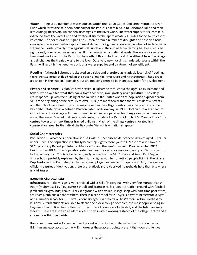
6 – Promote community
spirit/facilities
Built up area is drawn in such a
way as to build a sustainable
community with no isolated areas
and easy access to village facilities.
Provision of a skateboard park
provides facilities for young
people.
YY Y X
7 – Protect village assets Development promotes use of
village facilities. YY 0 Y
8 – Genuine housing need
with local connections can
live in village
Provision of affordable housing in
the sites allocated outside the
current built up boundary enables
locals to stay in the village.
YY X YY
9 – Encourage community
to use local businesses
Sites have been chosen to be
within walking distance of the
centre of village so that residents
have easy access to local shops
and businesses.
YY 0 Y

15
June 2015
Policy 2: Housing Site Allocation
The Neighbourhood Plan allocates the following sites for housing development, as shown on the Policies
Map, subject to the development principles outlined:
i. Approximately 14 dwellings on land at Balcombe House Gardens and Rectory Gardens on
Haywards Heath Road adjoining the village centre, comprising a mix of 1, 2 and 3 bedroom
dwellings, provided the scheme comprises proposals for:
a. the delivery of a public car park of 10 spaces to be transferred to the district or parish
council for ongoing management and operation;
b. the retention and improvement of the existing tree-lined frontage to Haywards Heath
Road; and
c. it can be demonstrated that they will sustain or enhance the significance of the setting
to both the Grade II listed Balcombe House and the Balcombe Conservation Area
heritage assets;
ii. The re-siting of a new Rectory on land at Balcombe House Church Woods South
iii. Approximately 14 dwellings on land at Barn Field off Haywards Heath Road comprising a mix of
2,3 and 4 bedroom dwellings, provided the scheme comprises proposals for traffic calming
measures to Haywards Heath Road to the satisfaction of the highways authority;
iv. Approximately 14 dwellings on land north of Station House on London Road, comprising a mix of
1, 2 and 3 bedroom houses and flats.
In all cases, the design of the scheme must demonstrate that it will conserve and enhance the landscape
and natural beauty of the High Weald Area of Outstanding Natural Beauty.
Development proposals will be expected to conform to the affordable housing policies of the Mid Sussex
development plan.
Alternative Policy Options
1. No policy on site allocation which would mean that we are left open to speculative and hostile
planning applications and development that could not be controlled by village opinion.
Balcombe Sustainability Objective SA Assessment of Policy Impact of
Policy
Impact of
Alternative
Policy 1
1 - Protect & enhance
countryside/rural setting
Any development is likely to have a
detrimental effect however development
is sited and scaled to minimise the effect.
Most development will be adjacent to the
existing boundary and will be required to
conform to development plan policies in
respect of the control of development in
the countryside.
0 XX
2 - Reduce impact of traffic Development is likely to increase traffic,
however sites have been selected to
minimise the effect by providing or linking
to existing footways. Sites have been
selected to be within walking distance of
village amenities and public transport.
0 XX
3 – Enhance the centre of the village Provision of a car park as part of the
Rectory Gardens development will
alleviate the car parking issues in the
centre of the village and potentially
provide parking for stop and shop traffic.
Y X

16
June 2015
4 – Protect & enhance biodiversity,
wildlife
Any development is likely to have a
detrimental effect however connectivity
of habitats will be maintained in site
design.
X X
5 – Increase energy efficiency &
renewables
The Rectory Gardens development
proposes a small biomass generator to
provide district power to part of the
development. New development
provides an opportunity to include energy
efficiency in any development.
YY 0
6 – Promote community
spirit/facilities
All sites provide easy walking access to the
village centre and village amenities such
as the school, halls, the rec and social
club. Provision of a skate park provides
facilities for young people. Staggered and
small developments will enable
integration into village life for new
residents.
YY X
7 – Protect village assets Development promotes use of village
facilities. YY 0
8 – Genuine housing need with local
connections can live in village
Provision of affordable housing in the sites
allocated enables locals to stay in the
village. Housing needs survey has
identified smaller units and these are
provided in the plan.
YY Y
9 – Encourage community to use
local businesses
Sites have been chosen to be within
walking distance of the centre of village so
that residents have easy access to local
shops and businesses.
YY 0
More detailed sustainability evaluation of each site has also taken place. The first draft was
completed in May 2014. This has now been updated following consultation on the 6 shortlisted
sites. The initial assessments and the revised assessments are shown in Appendices E and F.

17
June 2015
Policy 3 – Housing Design
The scale, density, massing, height, landscape design, layout and materials of all development proposals,
including alterations to existing buildings, will be required to reflect the architectural and historic
character and scale of the surrounding buildings and to avoid any significant detrimental effect on the
landscape and natural beauty of the High Weald Area of Outstanding Natural Beauty.
Unless otherwise proposed in Policy 2, development proposals will be expected to demonstrate they
accord with the provisions of the Balcombe Village Design Brief and with the following principles:
i. approximately 75% of the total number of dwellings of the scheme, and especially the affordable
homes, are no larger than 3 bedroom dwellings with a proportion suited to occupation by
households of retirement age;
ii. approximately 25% of the total number of dwellings of the scheme to comprise dwellings of no
more than 4 bedrooms; and
iii. they comply with affordable housing requirements of the Mid Sussex development plan.
Alternative Policy Options
1. Have no design brief – without a design brief we have no control of the look, feel and quality of
design.
Balcombe Sustainability Objective SA Assessment of Policy Impact of
Policy
Impact of
Alternative
Policy
option 1
1 - Protect & enhance
countryside/rural setting
The design brief provides guidance to
ensure developments complement
their setting.
0 X
2 - Reduce impact of traffic The design brief provides guidance to
ensure car parking is sensitive to the
environment within developments.
Footways and cycle provision within
developments provide alternatives to
motorised transport.
0 0
3 – Enhance the centre of the village Any infill development or conversion
in the village centre will have to
accord with the design brief.
YY X
4 – Protect & enhance biodiversity,
wildlife
Landscape design and retention of
habitat within developments will be a
priority.
0 0
5 – Increase energy efficiency &
renewables
Design and policies will allow use of
renewables and encourage energy
efficiency
YY 0
6 – Promote community
spirit/facilities
Layout and scale of sites will
encourage neighbourliness. YY 0
7 – Protect village assets Any conversion or extension of village
assets will have to accord with the
design brief.
YY XX
8 – Genuine housing need with local
connections can live in village
Housing development and scale has
been led by local needs. YY 0
9 – Encourage community to use local
businesses
Provision of footways and easy access
to village amenities will encourage
residents to use village businesses.
YY 0

18
June 2015
Policy 4 – Enterprise, Home Working & Broadband
The Neighbourhood Plan allocates land at Glebe Farm, Haywards Heath Road for B1-B8 uses, as shown on
the Policies Map, provided:
i. The design of the scheme will avoid any significant detrimental effect on the landscape and
natural beauty of the High Weald Area of Outstanding Natural Beauty; and
ii. The type of business development proposed is suited to a rural location in the Area of Outstanding
Natural Beauty and will make a contribution to the local economy.
Elsewhere within the built up area boundary defined by Policy 1, proposals to change part of the primary
use of a dwelling to a business use for home working, will be supported, provided they will not result in a
significant increase in vehicles serving the building nor in a loss of amenity to neighbouring households by
way of noise, odour or other such matter.
Proposals within the Parish to provide access to a super-fast broadband network to the village of
Balcombe, and outlying properties in the countryside, and to improve the speed of existing services, will be
supported, provided the location and design of any above-ground network installations reflect the
character of the local area.
Alternative Policy Options
1. No policy on enterprise, home working & broadband resulting in a lack of local employment
opportunities and a reliance on commuting.
Balcombe Sustainability Objective SA Assessment of Policy Impact of
Policy
Impact of
Alternative
Policy
option 1
1 - Protect & enhance
countryside/rural setting
Glebe Farm has some small scale
commercial businesses on site,
however the site extension will be
onto a Greenfield site.
X X
2 - Reduce impact of traffic Home working prevents the need to
commute however new businesses
at Glebe Farm will generate some
additional traffic, either from staff or
visitors.
0 XX
3 – Enhance the centre of the village Policy allows for the enhancement of
the village centre through conversion
of a dwelling to a business.
Y 0
4 – Protect & enhance biodiversity,
wildlife
Site extension of Glebe Farm will be
onto a greenfield site. 0 0
5 – Increase energy efficiency &
renewables
Home working reduces impact of
travel/traffic however heating a
house for one worker may have a
negative impact.
Y X
6 – Promote community
spirit/facilities
Additional local employment could
be provided. Y X
7 – Protect village assets No effect 0 0
8 – Genuine housing need with local
connections can live in village
Encourages local employment YY 0
9 – Encourage community to use
local businesses
More people working from home
and locally means more people will
use local businesses such as the
shop, pub and tea rooms.
Y X

19
June 2015
Policy 5 – Balcombe Village Centre
The Neighbourhood Plan defines the Balcombe Village Centre on the Policies Map. Within the Village
Centre, development proposals that will result in the loss of any village centre uses will be resisted unless:
i. the village centre unit has been vacant for at least two years;
ii. it can be demonstrated that all reasonable efforts have been to secure another village centre
use; and
iii. a viability appraisal can demonstrate there is no reasonable prospect of the unit becoming
commercially viable.
Proposals for a change of use of a building or for the development of land within the village centre for
commercial use will be supported, provided they accord with the design policies of the Neighbourhood
Plan and Mid Sussex development plan and specifically they will conserve and enhance the landscape and
natural beauty of the High Weald Area of Outstanding Natural Beauty.
Alternative Policy Options
1. Have no policy on Balcombe village centre which would mean no control over the development of
the village centre including conversions and change of use.
Balcombe Sustainability Objective SA Assessment of Policy Impact of
Policy
Impact of
Alternative
policy
option 1
1 - Protect & enhance countryside/rural
setting
No impact on countryside,
rural setting maintained. 0 0
2 - Reduce impact of traffic Any additional services could
reduce the need to travel. Y X
3 – Enhance the centre of the village Allows for new commercial
enterprise and maintaining
existing commercial
premises.
YY XX
4 – Protect & enhance biodiversity, wildlife No impact. 0 0
5 – Increase energy efficiency & renewables Reduces travel need if
residents are able to access
services locally.
YY X
6 – Promote community spirit/facilities Encourages community spirit
though use of local
facilities/village hub.
YY XX
7 – Protect village assets Yes. YY XX
8 – Genuine housing need with local
connections can live in village
Provides sustainable
community. Those with low
incomes and mobility issues
can access essential goods
and services.
YY X
9 – Encourage community to use local
businesses
A minimum level of services
builds a village hub which
alleviates the need to travel
outside the village.
YY XX

20
June 2015
Policy 6 – Balcombe CE Primary School
Development proposals to extend Balcombe CE Primary School to provide additional education facilities, as
shown on the Policies Map, will be supported, provided:
i. the design of the scheme will avoid any significant detrimental effect on the landscape and natural
beauty of the High Weald Area of Outstanding Natural Beauty; and
ii. the scheme will deliver the necessary supporting infrastructure, including ancillary services.
Alternative Policy Options
1. No policy on extending the primary school would mean that we have not set out our commitment to
support the educational infrastructure required for long term sustainability.
Balcombe Sustainability Objective SA Assessment of Policy Impact
of
Policy
Impact of
Alternative
Policy
option 1
1 - Protect & enhance
countryside/rural setting
Enlargement of school likely to have minor
effect on the landscape but will enable the
village to maintain its vibrant and well-regarded
primary school.
0 0
2 - Reduce impact of traffic There would be some additional traffic but if
the car park at the Rectory Gardens has been
built this would mitigate the effect. Reduces
need of families to travel to school outside
village.
0 X
3 – Enhance the centre of the village No effect 0 0
4 – Protect & enhance biodiversity,
wildlife
Enlargement of school likely to have minor
effect on biodiversity X 0
5 – Increase energy efficiency &
renewables
An opportunity for an extension to be more
energy efficient than current building. Y X
6 – Promote community
spirit/facilities
Would ensure all local children could attend the
village school. YY X
7 – Protect village assets Proposal enhances an identified asset. YY XX
8 – Genuine housing need with local
connections can live in village
Would ensure all local children could attend the
village school. YY XX
9 – Encourage community to use
local businesses
Increased activity at school could impact sales
at local businesses. Y XX

21
June 2015
Policy 7 – Community Facilities
Proposals to improve the viability of an established community use of the following buildings and
facilities by way of the extension or partial redevelopment of existing buildings will be supported,
provided the design of the scheme will avoid any significant detrimental effect on the landscape and
natural beauty of the High Weald Area of Outstanding Natural Beauty:
i. Railway Station, London Road
ii. GP Surgery, Haywards Heath Road
iii. Balcombe CE Primary School and Playing Field, London Road
iv. Balcombe Stores & Post Office, Haywards Heath Road
v. St. Mary’s Church, London Road
vi. Pavilion, off Stockcroft Road
vii. Victory Hall including Social Club and Car Park, Bramble Hill
viii. Parish Room, Stockcroft Road
ix. Half Moon Inn, Haywards Heath Road
x. Scout Hut, London Road
xi. Bramble Hall, Bramble Hill
xii. Tennis Courts, Haywards Heath Road
xiii. Skateboard Park, London Road (as proposed by Policy 8).
Alternative Policy Options
1. Having no policy on community facilities would mean that these facilities could be subject to
closure, change of use or re-development.
Balcombe Sustainability Objective SA Assessment of Policy Impact of
Policy
Impact of
Alternative
Policy
option 1
1 - Protect & enhance
countryside/rural setting
Maintains our rural village. Y X
2 - Reduce impact of traffic Maintains facilities so that residents
don’t have to travel outside the
village to access services.
Y XX
3 – Enhance the centre of the village Maintains centre of village facilities YY XX
4 – Protect & enhance biodiversity,
wildlife
Reduces impact of any development
on biodiversity and wildlife.
0 0
5 – Increase energy efficiency &
renewables
No effect 0 0
6 – Promote community
spirit/facilities
Maintains our village facilities to the
continued benefit of the community
YY XX
7 – Protect village assets Yes. YY XX
8 – Genuine housing need with local
connections can live in village
Provides sustainable community.
Those with low incomes and mobility
issues can access essential goods and
services.
Y XX
9 – Encourage community to use local
businesses
A minimum level of facilities builds a
village hub which alleviates the need
to travel outside the village for social
events.
YY XX

22
June 2015
Policy 8 – Skateboard park
The Neighbourhood Plan allocates land off London Road, as shown on the Policies Map, for a new
skateboard park facility.
Alternative Policy Options
1. Having no policy for allocation of land for a skateboard park and therefore having no control over
siting or no provision at all
2. Allocating an alternative site for a skateboard park eg at the recreation ground
Balcombe Sustainability Objective SA Assessment of Policy Impact of
Policy
Impact of
Alternative
Policy
option 1
Impact of
Alternative
Policy
option 2
1 - Protect & enhance
countryside/rural setting
No X 0 Y
2 - Reduce impact of traffic Provides local recreational
facilities without the need to
drive.
Y X Y
3 – Enhance the centre of the village No impact 0 0 0
4 – Protect & enhance biodiversity,
wildlife
Limited detrimental effect on
biodiversity and wildlife as the
site is close to the road.
X X X
5 – Increase energy efficiency &
renewables
No effect 0 0 0
6 – Promote community
spirit/facilities
Provides facilities for young
people who currently have
few local facilities. We know
following previous community
consultation that whilst a
location at the recreation
ground would be preferable
for the young people a
significant number of
residents feel that a
skateboard park would be too
noisy.
YY XX 0
7 – Protect village assets Provides an additional village
asset YY XX Y
8 – Genuine housing need with local
connections can live in village
No effect 0 0 0
9 – Encourage community to use
local businesses
No effect 0 0 0

23
June 2015
Policy 9 – Local Green Spaces
The Neighbourhood Plan designates Local Green Spaces in the following locations, as shown on the
Policies Map:
i. Recreation Ground;
ii. Cricket Field;
iii. School Green;
iv. Bowling Green;
v. Alley Green;
vi. Bagpiths Field;
vii. Barn Meadow Play Area;
viii. Scout Hut Amenity Space; and
ix. School Playing Field.
Proposals for development in a Local Green Space will be resisted, unless they are ancillary to the use of
the land for a public recreational purpose or are required for a statutory utility infrastructure purpose.
Alternative Policy Options
1. No policy on green spaces
Balcombe Sustainability Objective SA Assessment of Policy Impact of
Policy
Impact of
Alternative
Policy
option 1
1 - Protect & enhance countryside/rural
setting
Conserves green space. YY XX
2 - Reduce impact of traffic No Effect 0 0
3 – Enhance the centre of the village Retains green spaces within the
built up area YY XX
4 – Protect & enhance biodiversity,
wildlife
Conserves biodiversity and wildlife YY XX
5 – Increase energy efficiency &
renewables
No Effect 0 0
6 – Promote community spirit/facilities Yes ensures the village maintains all
the current recreational facilities for
community cohesion.
YY XX
7 – Protect village assets Assets maintained through this
policy YY XX
8 – Genuine housing need with local
connections can live in village
No Effect 0 0
9 – Encourage community to use local
businesses
No Effect 0 0

24
June 2015
Policy 10 – Burial Ground Extension
The Neighbourhood Plan allocates land off London Road, as shown on the Policies Map, for the purpose of
providing an additional burial ground. Proposals for any new buildings ancillary to this use will be
supported provided they avoid any significant detrimental effect on the landscape and natural beauty of
the High Weald Area of Outstanding Natural Beauty.
Alternative Policy Options
1. No policy on burial ground provision which would mean that we may run out of burial plots within
the next 10 years.
2. An alternative siting of a burial ground extension which may be further away from the church and
the village centre. There are no other obvious sites available.
Balcombe Sustainability Objective SA Assessment of Policy Impact of
Policy
Impact of
Alternative
Policy
option 1
Impact of
Alternative
Policy
option 2
1 - Protect & enhance
countryside/rural setting
Policy has a small
detrimental effect on the
countryside setting at the
entrance to the village.
X 0 X
2 - Reduce impact of traffic No Effect 0 X 0
3 – Enhance the centre of the
village
No Effect 0 0 0
4 – Protect & enhance
biodiversity, wildlife
Negligible effect or positive
– it is currently grazed land
and may become more bio-
diverse,
0 0 0
5 – Increase energy efficiency &
renewables
No Effect 0 X 0
6 – Promote community
spirit/facilities
Provides an extension to a
community facility as there
is no more space in the
current graveyard.
YY XX X
7 – Protect village assets Enables residents to be
buried locally. YY XX Y
8 – Genuine housing need with
local connections can live in
village
No Effect
0 0 0
9 – Encourage community to use
local businesses
No Effect Y X Y

25
June 2015
Policy 11 – Station Car Parking
The Neighbourhood Plan allocates land off London Road, as shown on the Policies Map, for the purpose of
providing additional car parking spaces for Balcombe Station.
Alternative Policy Options
1. No policy on additional station car parking
Balcombe Sustainability Objective SA Assessment of Policy Impact of
Policy
Impact of
Alternative
Policy
option 1
1 - Protect & enhance countryside/rural
setting
Potentially detrimental effect as part of a
field will be used for car parking. (There is
already sufficient space in the station car
park but it isn’t used because there is a
charge.) However because commuter cars
are parked on neighbouring roads causing
congestion and damage to verges, the net
effect is viewed as positive.
Y 0
2 - Reduce impact of traffic Yes this will assist considerably with the
effects of commuter parking on Newlands
and Bramble Hill and the conflicts that
creates with through traffic and local
residents parking.
YY XX
3 – Enhance the centre of the village Reduces commuter parking in the village
centre. Y XX
4 – Protect & enhance biodiversity,
wildlife
Potentially detrimental effect on
biodiversity and wildlife in that some
green space is lost to an albeit very rural
car park. It does not affect the SSNI
portion of the field. It would also prevent
parking on verges which is having a
detrimental effect on the approach to the
village.
Y 0
5 – Increase energy efficiency &
renewables
No Effect unless it increases use of public
transport. 0 0
6 – Promote community spirit/facilities Resolve the parking issues for residents of
Newlands and Bramble Hill. YY X
7 – Protect village assets Provides parking for station and
encourages commuters to use the station. YY XX
8 – Genuine housing need with local
connections can live in village
No Effect 0 0
9 – Encourage community to use local
businesses
Encourages use of station Y X

26
June 2015
Policy 12 – Renewable Energy
Proposals comprising domestic and community-scale renewable energy development will be supported,
provided the design of the scheme will avoid any significant detrimental effect on the landscape and
natural beauty of the High Weald Area of Outstanding Natural Beauty.
Alternative Policy Options
1. No policy on renewable energy which means developers will only need to conform to the minimum
codes as set out in planning policy.
Balcombe Sustainability Objective SA Assessment of Policy Impact of
Policy
Impact of
Alternative
Policy
option 1
1 - Protect & enhance countryside/rural
setting
Provided the design of the
scheme will avoid any
significant detrimental effect on
the landscape and natural
beauty of the High Weald Area
of Outstanding Natural Beauty.
0 0
2 - Reduce impact of traffic No Effect 0 0
3 – Enhance the centre of the village No Effect 0 0
4 – Protect & enhance biodiversity, wildlife In the broader context energy
efficiency should have a
positive effect on wildlife and
biodiversity
Y X
5 – Increase energy efficiency & renewables Yes YY XX
6 – Promote community spirit/facilities May cause some difference of
opinion!
X XX
7 – Protect village assets Not directly affected. 0 0
8 – Genuine housing need with local
connections can live in village
No Effect 0 0
9 – Encourage community to use local
businesses
Proposals for renewable energy
generation from local
organisations and landowners
could have a positive economic
benefit.
Y X
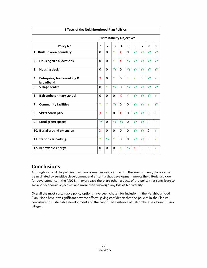
Cumulative effects of the Neighbourhood Plan policies
While some of the policy options may individually have a minor impact (either positive or negative)
on the environmental, social and economic characteristics of the parish, collectively they may have a
much more significant impact. As part of this appraisal, the combined impacts of the policy
proposals have been considered. It is acknowledged that there are a number of uncertainties in this
respect, especially when considering the effects over the time scale of the Plan.
In most cases, assessing the social and economic effects of a policy results in many of the negative
environmental sustainability impacts identified for individual policies being cancelled out. When
appraising the cumulative impacts of all the policies within the Neighbourhood Plan these negative
impacts have been addressed by other policies, illustrated in the table of cumulative effects, below.
27
June 2015
Effects of the Neighbourhood Plan Policies
Sustainability Objectives
Policy No 1 2 3 4 5 6 7 8 9
1. Built up area boundary 0 0 Y X 0 YY YY YY YY
2. Housing site allocations 0 0 Y X YY YY YY YY YY
3. Housing design 0 0 YY 0 YY YY YY YY YY
4. Enterprise, homeworking &
broadband
X 0 Y 0 Y Y 0 YY Y
5. Village centre 0 Y YY 0 YY YY YY YY YY
6. Balcombe primary school 0 0 0 X Y YY YY YY Y
7. Community facilities Y Y YY 0 0 YY YY Y YY
8. Skateboard park X Y 0 X 0 YY YY 0 0
9. Local green spaces YY 0 YY YY 0 YY YY 0 0
10. Burial ground extension X 0 0 0 0 YY YY 0 Y
11. Station car parking Y YY Y 0 0 YY YY 0 Y
12. Renewable energy 0 0 0 Y YY X 0 0 Y
Conclusions Although some of the policies may have a small negative impact on the environment, these can all
be mitigated by sensitive development and ensuring that development meets the criteria laid down
for developments in the ANOB. In every case there are other aspects of the policy that contribute to
social or economic objectives and more than outweigh any loss of biodiversity.
Overall the most sustainable policy options have been chosen for inclusion in the Neighbourhood
Plan. None have any significant adverse effects, giving confidence that the policies in the Plan will
contribute to sustainable development and the continued existence of Balcombe as a vibrant Sussex
village.

28
June 2015
APPENDIX A
Summary of Plans and Programmes used to inform this Sustainability Appraisal
Action with Communities in Rural England (ACRE) Rural evidence project November 2013
Balcombe Parish Plan 2007
Balcombe Housing Needs Survey 2009
http://balcombeparishcouncil.files.wordpress.com/2012/10/balcombe-housing-needs-survey.pdf
Balcombe Neighbourhood Planning Aims Presentations and Questionnaire 2012/13
http://balcombeparishcouncil.com/neighbourhood-planning/neighbourhood-planning-open-event/
http://balcombeparishcouncil.com/neighbourhood-planning/aims-questionnaire-march-2013/
Balcombe Residents Consultation Sessions June 2014 and December 2014.
Mid Sussex District Plan Consulation Draft November 2014
Mid Sussex District Plan Sustainability Appraisal October 2014
High Weald Area of Outstanding Natural Beauty Management Plan
Ardingly and Hurstpierpoint & Sayers Common Scoping Reports for Sustainability Appraisal
Rural Community Profile for Balcombe produced by AIRS November 2013
Sussex Biodiversity Records Office Biodiversity Report for Balcombe Parish February 2014
Mid Sussex District Council mapping of SSSI, SNCI, Flood areas, Ancient Woodland, Balcombe
Parish Plan area
2011 Census

29
June 2015
APPENDIX B
Summary of Responses from Consultees on Sustainability Objectives, March 2014
Date Consultee Comments BPC
response to
comments
3
March
2014
High Weald
Area of
Outstanding
Natural
Beauty
The scoping report appears to make thorough and appropriate
reference to the High Weald AONB and landscape and countryside
matters generally. Additional indicators for natural beauty and
countryside in addition to ancient woodland may be desirable and the
Unit would be happy to discus these further if appropriate (may
include elements such as historic lanes, field boundaries, meadows
etc). Landscape matters are therefore adequately covered by the
scoping report and the Unit has no further comments.
No further
action taken
at this stage.
7 April
2014
West Sussex
County
Council
I acknowledge receipt of your consultation email of 7th March 2014
and the March 2014 Scoping Report for the Balcombe Neighbourhood
Plan Sustainability Appraisal. I thank you for inviting West Sussex
County Council to comment and would advise that on this occasion
there are no comments that we would wish to make.
No further
action taken
at this stage.
7 April
2014
Natural
England
The document appears to be a good start to the SA process, and we
welcome the recognition and importance given to the natural
environment. Just two points at this stage:
SA Objective 1 relating to the countryside (page 11) is supported. One
of the key issues is the extent to which development proposals
succeed in protecting and enhancing the character of the
countryside. This can be assessed with reference to the Landscape
Character Assessment of designated and other landscapes, and the use
of some form of Landscape and Visual Impact Assessment, in
considering proposals. Monitoring the outcome of development
management decisions is an effective way of understanding whether
the plan’s objectives are being delivered and the effectiveness of its
policies.
SA Objective 4 relating to the biodiversity (page 11) is also
supported. The indicators listed are fine for baseline data and long
term monitoring, however (for the reasons listed above), monitoring
the outcome of planning decisions is important.
Due to the current pressure of consultations on land-use plans, I have
not been able to spend the time I would have wished reviewing and
commenting on your Scoping Report. Nevertheless, I hope you find
these brief comments helpful.
Include a
Landscape
and Visual
Impact
Assessment
as part of
the planning
process.
Monitor
planning
decisions
carefully.
English
Heritage
Acknowledgement of receipt only
Environment
Agency
Acknowledgment of receipt only
Mid Sussex
DC
Support and assistance in the wording and structure of the original
Scoping Report so no further comments on the final document.

30
June 2015
APPENDIX C
Areas of SSSI, SSNI and the Flood Zone.

31
June 2015
APPENDIX D
Village Conservation Area and Ancient Woodland

32
June 2015
APPENDIX E
Individual Site Assessments (June 2014)
Before community consultation or discusssions with local land owners

33
June 2015
APPENDIX F
Shortlisted Site Assessments following Community Consultation in December 2014
and Discussions with Local Land owners
Site Assessment versus Sustainability Objectives – December 2014
Site
Op
tion
1 - P
rote
ct & e
nh
an
ce
cou
ntry
side
/rura
l
settin
g
2 - R
ed
uce
imp
act o
f
traffic
3 –
En
ha
nce
the
cen
tre
of th
e v
illag
e
4 –
Pro
tect &
en
ha
nce
bio
div
ersity
, wild
life
5 –
Incre
ase
en
erg
y
efficie
ncy
& re
ne
wa
ble
s
6 –
Pro
mo
te
com
mu
nity
spirit/fa
cilities
7 –
Pro
tect villa
ge
asse
ts
8 –
Ge
nu
ine
ho
usin
g
ne
ed
with
loca
l
con
ne
ction
s can
live
in
villa
ge
9 –
En
cou
rag
e
com
mu
nity
to u
se lo
cal
bu
sine
sses
F Rectory Gardens �������� 0 �������� 0 0 �������� �������� 0 ��������
A Balcombe House Gardens ���� 0 �������� 0 0 �������� �������� 0 ��������
Q Church Woods xx x x x 0 ���� 0 0 ��������
B2 Vintens Glasshouses x 0 0 xx 0 x 0 0 0
D Barn Field x �������� 0 xx 0 ���� ���� 0 0
G Land North of Station
House ���� ���� ���� x 0 �������� �������� 0 ��������
Recommendations and Mitigation Measures:
Sites A, F, Q
Whilst originally it was felt that sites A, F and Q were positive in terms of reducing the impact of traffic in the village
because of the inclusion of a village centre carpark in the plans our community consultation suggests that residents are
concerned about more traffic on an already very busy stretch of the Haywards Heath Road, particularly at school pick
up and drop off times. There is concern about access to these sites hence the change in ratings to neutral.
There was also particular concern about the effect that development on site Q would have to the look and feel of the
approach to the village and so it has not been allocated.
Site D
Plans for the site have been amended following discussion with the Parish Council so that houses would be built at right
angles to the road and lower down the slope so as to preserve the view over open countryside for the houses opposite.
The allotments, local pond and trees will be preserved on site with a footpath linking the site to the local network of
footpaths. Traffic calming on the Haywards Heath Rd will be a required element of this development. The site is within
easy walking distance of the train station, nursery school, tennis courts and within walking distance of the village
centre, primary school and church.
Site G
This site is ideally located close to the village centre and railway station. Although some tree felling will be necessary,
many of the trees are Ash and may suffer from disease. It’s not a particularly attractive part of the village and is widely
supported as a suitable site by residents.
Overall Conclusion:
Sites A, F, G and D will be allocated in the Neighbourhood Plan.

34
June 2015
Important Note
Some of the sites have been renamed as they do not correspond precisely with the original boundaries.
Now Was
A Balcombe House Gardens Balcombe House 2
F Rectory Gardens Balcombe House 1
Q Church Woods Balcombe House 3
D Barn Field Barn Field
G Land North of Station House Station Nursery
B2 Vintens Glasshouses Vintens Glasshouses