summary of amendments to new city plan kogarah local ... · new city plan gazetted amendment no.2...
TRANSCRIPT
New City Plan Gazetted Amendment No.2
Summary of Amendments to Kogarah Local Environmental Plan 2012
Note: This document is a plain English summary for explanatory purposes only. Refer to Kogarah Local Environmental Plan 2012 on the NSW legislation website for further information.
HEADLINE Gazetted on 26 May 2017 The New City Plan (Amendment No.2) to Kogarah Local Environmental Plan 2012 was gazetted on 26 May 2017. A number of changes to the New City Plan (as resolved by Council on 4 April 2016) have been made by the Department of Planning. The following is a summary of changes to the New City Plan and provides a comparison of the gazetted LEP, as compared to the plan as exhibited and as resolved by Council on 4 April 2016.
Gazettal of New City Plan
Gazettal of New City Plan
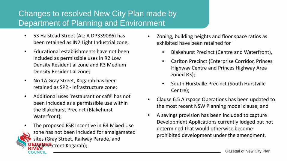
Changes to resolved New City Plan made by Department of Planning and Environment
• 53 Halstead Street (AL: A DP339086) has been retained as IN2 Light Industrial zone;
• Educational establishments have not been included as permissible uses in R2 Low Density Residential zone and R3 Medium Density Residential zone;
• No 1A Gray Street, Kogarah has been retained as SP2 - Infrastructure zone;
• Additional uses `restaurant or café' has not been included as a permissible use within the Blakehurst Precinct (Blakehurst Waterfront);
• The proposed FSR Incentive in B4 Mixed Use zone has not been included for amalgamated sites (Gray Street, Railway Parade, and English Street Kogarah);
• Zoning, building heights and floor space ratios as exhibited have been retained for
• Blakehurst Precinct (Centre and Waterfront),
• Carlton Precinct (Enterprise Corridor, Princes Highway Centre and Princes Highway Area zoned R3);
• South Hurstville Precinct (South Hurstville Centre);
• Clause 6.5 Airspace Operations has been updated to the most recent NSW Planning model clause; and
• A savings provision has been included to capture Development Applications currently lodged but not determined that would otherwise become prohibited development under the amendment.
Gazettal of New City Plan
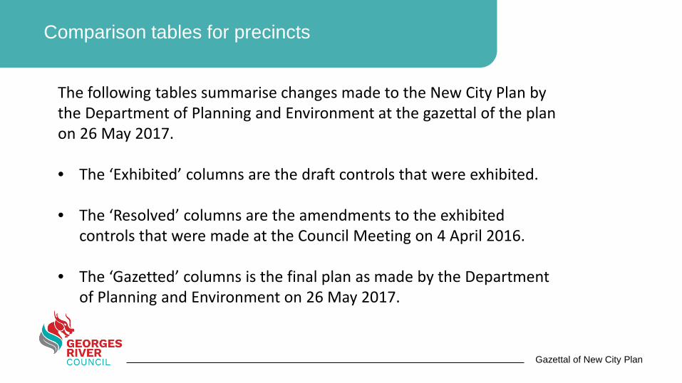
Comparison tables for precincts
The following tables summarise changes made to the New City Plan by the Department of Planning and Environment at the gazettal of the plan on 26 May 2017. • The ‘Exhibited’ columns are the draft controls that were exhibited. • The ‘Resolved’ columns are the amendments to the exhibited
controls that were made at the Council Meeting on 4 April 2016.
• The ‘Gazetted’ columns is the final plan as made by the Department of Planning and Environment on 26 May 2017.
Gazettal of New City Plan
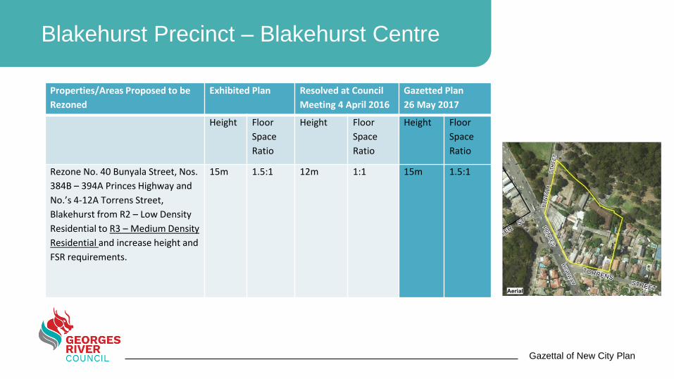
Properties/Areas Proposed to be Rezoned
Exhibited Plan Resolved at Council Meeting 4 April 2016
Gazetted Plan 26 May 2017
Height
Floor Space Ratio
Height Floor Space Ratio
Height Floor Space Ratio
Rezone No. 40 Bunyala Street, Nos. 384B – 394A Princes Highway and No.’s 4-12A Torrens Street, Blakehurst from R2 – Low Density Residential to R3 – Medium Density Residential and increase height and FSR requirements.
15m 1.5:1 12m 1:1
15m 1.5:1
Blakehurst Precinct – Blakehurst Centre
Gazettal of New City Plan
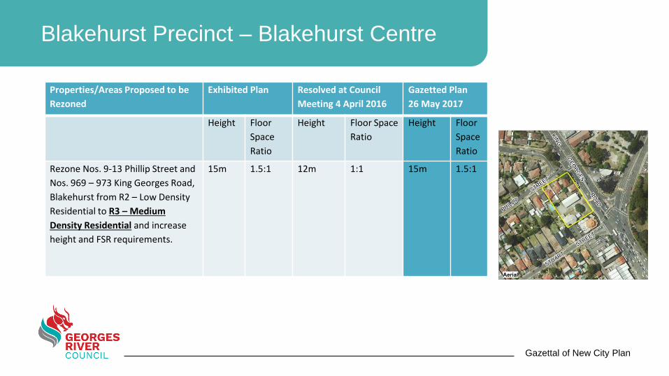
Properties/Areas Proposed to be Rezoned
Exhibited Plan Resolved at Council Meeting 4 April 2016
Gazetted Plan 26 May 2017
Height
Floor Space Ratio
Height Floor Space Ratio
Height Floor Space Ratio
Rezone Nos. 9-13 Phillip Street and Nos. 969 – 973 King Georges Road, Blakehurst from R2 – Low Density Residential to R3 – Medium Density Residential and increase height and FSR requirements.
15m 1.5:1 12m
1:1
15m 1.5:1
Blakehurst Precinct – Blakehurst Centre
Gazettal of New City Plan
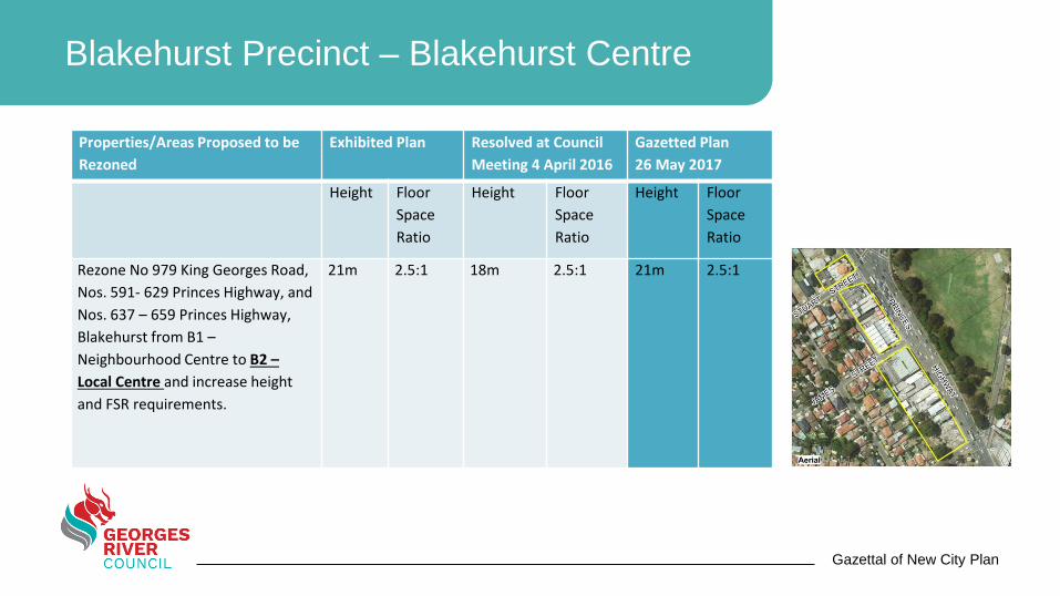
Properties/Areas Proposed to be Rezoned
Exhibited Plan Resolved at Council Meeting 4 April 2016
Gazetted Plan 26 May 2017
Height
Floor Space Ratio
Height Floor Space Ratio
Height Floor Space Ratio
Rezone No 979 King Georges Road, Nos. 591- 629 Princes Highway, and Nos. 637 – 659 Princes Highway, Blakehurst from B1 – Neighbourhood Centre to B2 – Local Centre and increase height and FSR requirements.
21m 2.5:1 18m
2.5:1
21m 2.5:1
Blakehurst Precinct – Blakehurst Centre
Gazettal of New City Plan
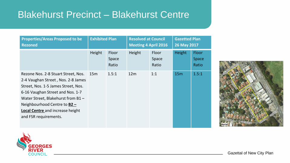
Properties/Areas Proposed to be Rezoned
Exhibited Plan Resolved at Council Meeting 4 April 2016
Gazetted Plan 26 May 2017
Height
Floor Space Ratio
Height Floor Space Ratio
Height Floor Space Ratio
Rezone Nos. 2-8 Stuart Street, Nos. 2-4 Vaughan Street , Nos. 2-8 James Street, Nos. 1-5 James Street, Nos. 6-16 Vaughan Street and Nos. 1-7 Water Street, Blakehurst from B1 – Neighbourhood Centre to B2 – Local Centre and increase height and FSR requirements.
15m 1.5:1 12m
1:1
15m 1.5:1
Blakehurst Precinct – Blakehurst Centre
Gazettal of New City Plan
Properties/Areas Proposed to be Rezoned
Exhibited Plan Resolved at Council Meeting 4 April 2016
Gazetted Plan 26 May 2017
Height
Floor Space Ratio
Height Floor Space Ratio
Height Floor Space Ratio
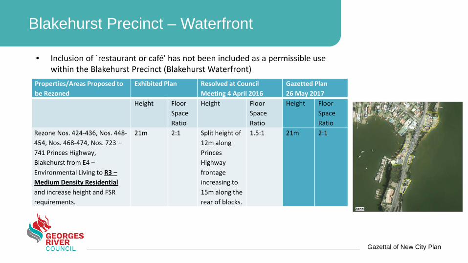
Rezone Nos. 424-436, Nos. 448-454, Nos. 468-474, Nos. 723 – 741 Princes Highway, Blakehurst from E4 – Environmental Living to R3 – Medium Density Residential and increase height and FSR requirements.
21m 2:1 Split height of 12m along Princes Highway frontage increasing to 15m along the rear of blocks.
1.5:1
21m 2:1
Blakehurst Precinct – Waterfront
• Inclusion of `restaurant or café' has not been included as a permissible use within the Blakehurst Precinct (Blakehurst Waterfront)
Gazettal of New City Plan
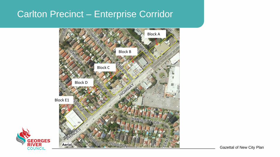
Carlton Precinct – Enterprise Corridor
Block A
Block B
Block C
Block D
Block E1
Gazettal of New City Plan
Carlton Precinct – Enterprise Corridor
Properties/Areas Proposed to be Rezoned Exhibited Plan Resolved at Council Meeting 4 April 2016
Gazetted Plan 26 May 2017
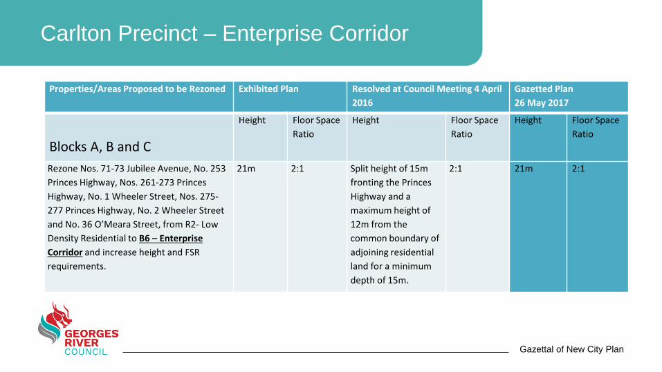
Blocks A, B and C
Height
Floor Space Ratio
Height Floor Space Ratio
Height Floor Space Ratio
Rezone Nos. 71-73 Jubilee Avenue, No. 253 Princes Highway, Nos. 261-273 Princes Highway, No. 1 Wheeler Street, Nos. 275-277 Princes Highway, No. 2 Wheeler Street and No. 36 O’Meara Street, from R2- Low Density Residential to B6 – Enterprise Corridor and increase height and FSR requirements.
21m 2:1 Split height of 15m fronting the Princes Highway and a maximum height of 12m from the common boundary of adjoining residential land for a minimum depth of 15m.
2:1
21m 2:1
Gazettal of New City Plan
Carlton Precinct – Enterprise Corridor
Properties/Areas Proposed to be Rezoned
Exhibited Plan Resolved at Council Meeting 4 April 2016
Gazetted Plan 26 May 2017
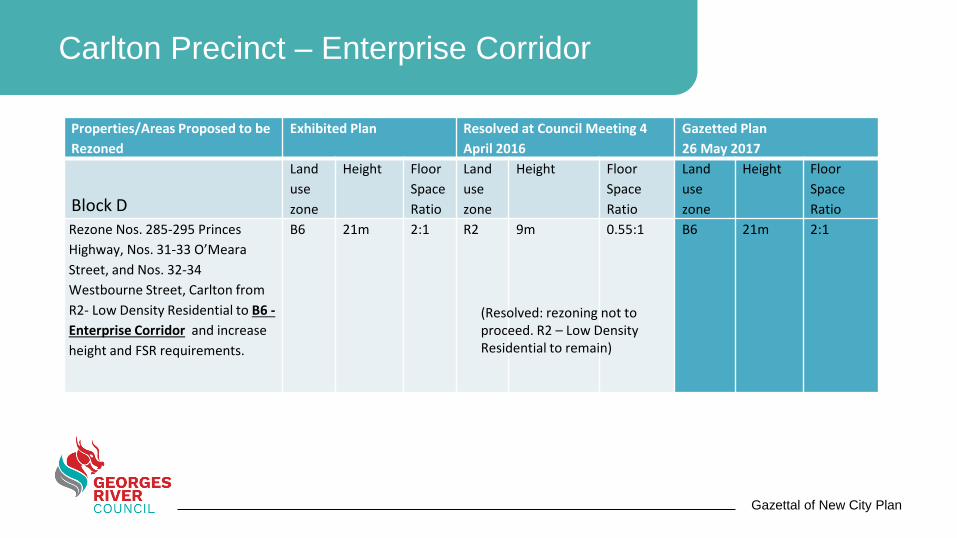
Block D
Land use zone
Height
Floor Space Ratio
Land use zone
Height Floor Space Ratio
Land use zone
Height Floor Space Ratio
Rezone Nos. 285-295 Princes Highway, Nos. 31-33 O’Meara Street, and Nos. 32-34 Westbourne Street, Carlton from R2- Low Density Residential to B6 -Enterprise Corridor and increase height and FSR requirements.
B6 21m 2:1 R2 9m
0.55:1
B6 21m 2:1
(Resolved: rezoning not to proceed. R2 – Low Density Residential to remain)
Gazettal of New City Plan
Carlton Precinct – Enterprise Corridor
Properties/Areas Proposed to be Rezoned Exhibited Plan Resolved at Council Meeting 4 April 2016
Gazetted Plan 26 May 2017
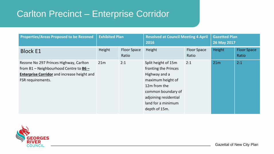
Block E1 Height
Floor Space Ratio
Height Floor Space Ratio
Height Floor Space Ratio
Rezone No 297 Princes Highway, Carlton from B1 – Neighbourhood Centre to B6 – Enterprise Corridor and increase height and FSR requirements.
21m 2:1 Split height of 15m fronting the Princes Highway and a maximum height of 12m from the common boundary of adjoining residential land for a minimum depth of 15m.
2:1
21m 2:1
Gazettal of New City Plan
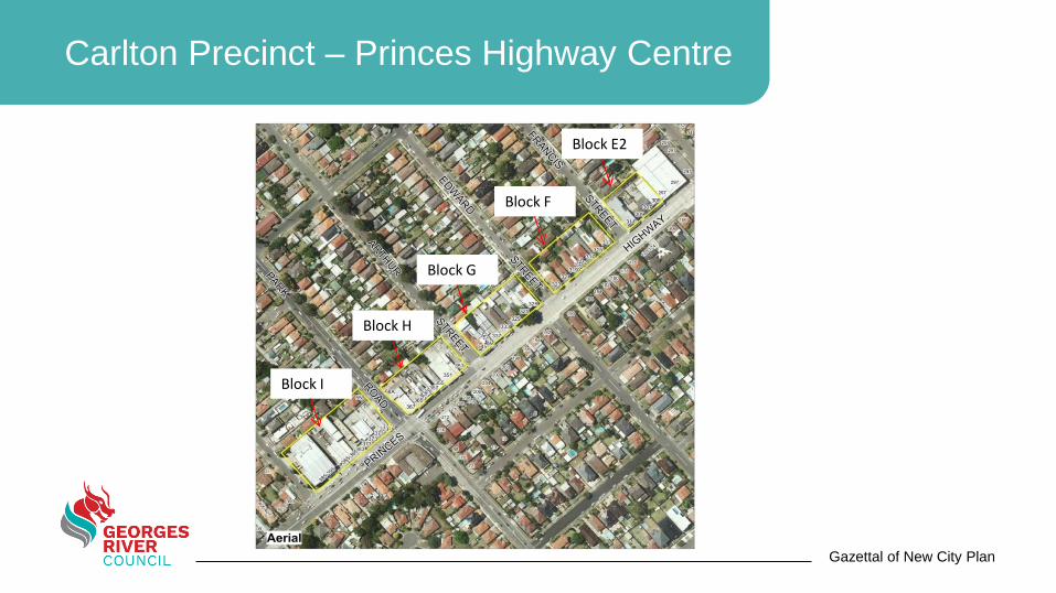
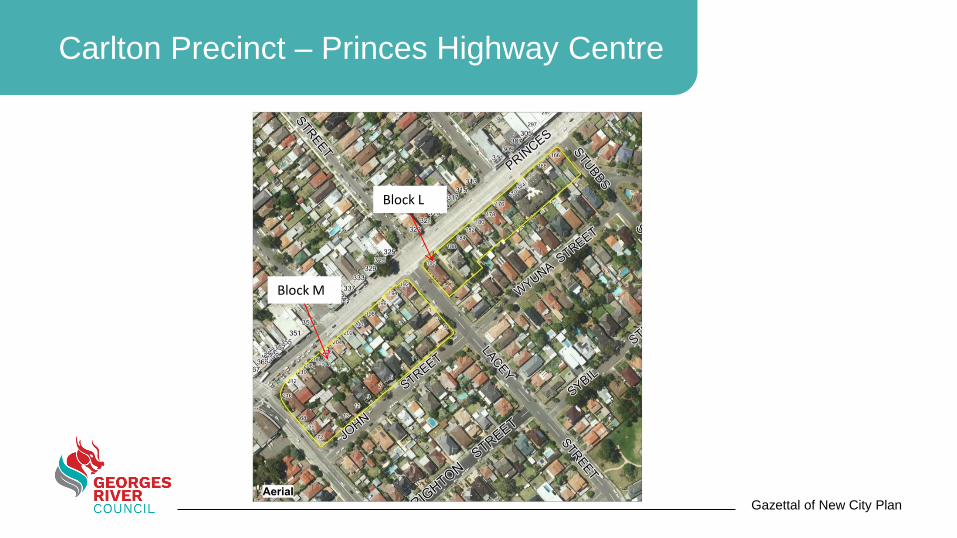
Carlton Precinct – Princes Highway Centre
Block E2
Block F
Block G
Block H
Block I
Gazettal of New City Plan
Carlton Precinct – Princes Highway Centre
Properties/Areas Proposed to be Rezoned Exhibited Plan Resolved at Council Meeting 4 April 2016
Gazetted Plan 26 May 2017
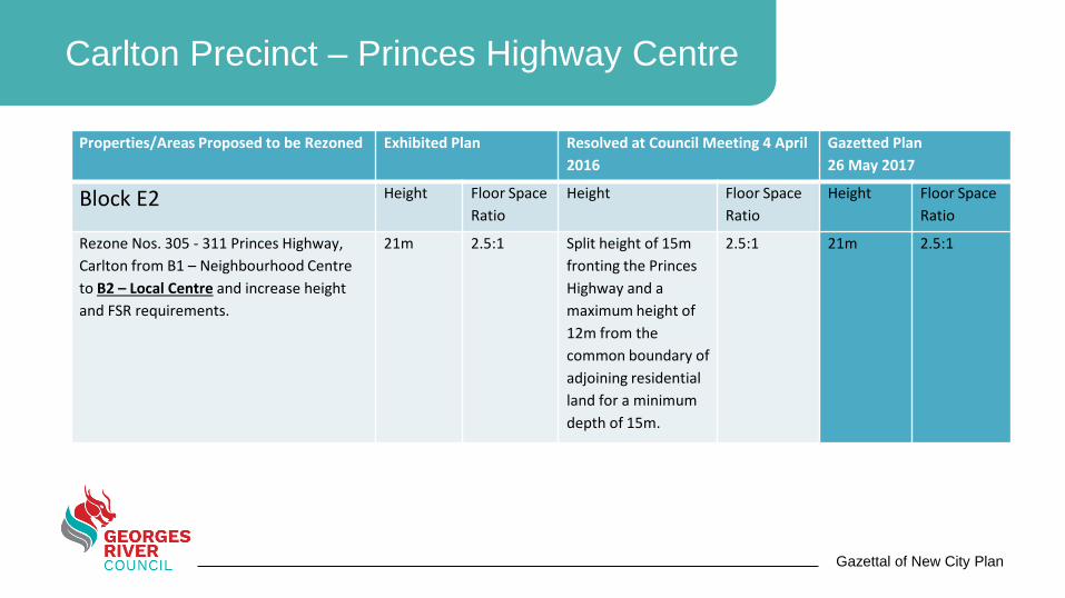
Block E2 Height
Floor Space Ratio
Height Floor Space Ratio
Height Floor Space Ratio
Rezone Nos. 305 - 311 Princes Highway, Carlton from B1 – Neighbourhood Centre to B2 – Local Centre and increase height and FSR requirements.
21m 2.5:1 Split height of 15m fronting the Princes Highway and a maximum height of 12m from the common boundary of adjoining residential land for a minimum depth of 15m.
2.5:1
21m 2.5:1
Gazettal of New City Plan
Carlton Precinct – Princes Highway Centre
Properties/Areas Proposed to be Rezoned
Exhibited Plan Resolved at Council Meeting 4 April 2016
Gazetted Plan 26 May 2017
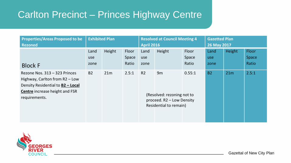
Block F
Land use zone
Height
Floor Space Ratio
Land use zone
Height Floor Space Ratio
Land use zone
Height Floor Space Ratio
Rezone Nos. 313 – 323 Princes Highway, Carlton from R2 – Low Density Residential to B2 – Local Centre increase height and FSR requirements.
B2 21m 2.5:1 R2 9m
0.55:1
B2 21m 2.5:1
(Resolved: rezoning not to proceed. R2 – Low Density Residential to remain)
Gazettal of New City Plan
Carlton Precinct – Princes Highway Centre
Properties/Areas Proposed to be Rezoned Exhibited Plan Resolved at Council Meeting 4 April 2016
Gazetted Plan 26 May 2017
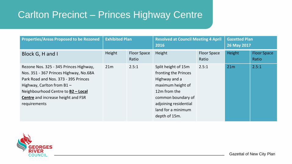
Block G, H and I Height
Floor Space Ratio
Height Floor Space Ratio
Height Floor Space Ratio
Rezone Nos. 325 - 345 Princes Highway, Nos. 351 - 367 Princes Highway, No.68A Park Road and Nos. 373 - 395 Princes Highway, Carlton from B1 – Neighbourhood Centre to B2 – Local Centre and increase height and FSR requirements
21m 2.5:1 Split height of 15m fronting the Princes Highway and a maximum height of 12m from the common boundary of adjoining residential land for a minimum depth of 15m.
2.5:1
21m 2.5:1
Gazettal of New City Plan
Name of document
Carlton Precinct – Princes Highway Centre
Properties/Areas Proposed to be Rezoned
Exhibited Plan Resolved at Council Meeting 4 April 2016 Gazetted Plan 26 May 2017
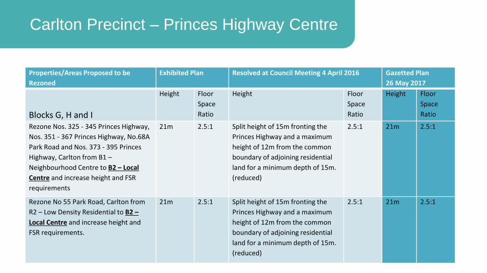
Blocks G, H and I
Height
Floor Space Ratio
Height Floor Space Ratio
Height Floor Space Ratio
Rezone Nos. 325 - 345 Princes Highway, Nos. 351 - 367 Princes Highway, No.68A Park Road and Nos. 373 - 395 Princes Highway, Carlton from B1 – Neighbourhood Centre to B2 – Local Centre and increase height and FSR requirements
21m 2.5:1 Split height of 15m fronting the Princes Highway and a maximum height of 12m from the common boundary of adjoining residential land for a minimum depth of 15m. (reduced)
2.5:1
21m 2.5:1
Rezone No 55 Park Road, Carlton from R2 – Low Density Residential to B2 – Local Centre and increase height and FSR requirements.
21m 2.5:1 Split height of 15m fronting the Princes Highway and a maximum height of 12m from the common boundary of adjoining residential land for a minimum depth of 15m. (reduced)
2.5:1
21m 2.5:1
Carlton Precinct – Princes Highway Centre
Properties/Areas Proposed to be Rezoned
Exhibited Plan Resolved at Council Meeting 4 April 2016
Gazetted Plan 26 May 2017
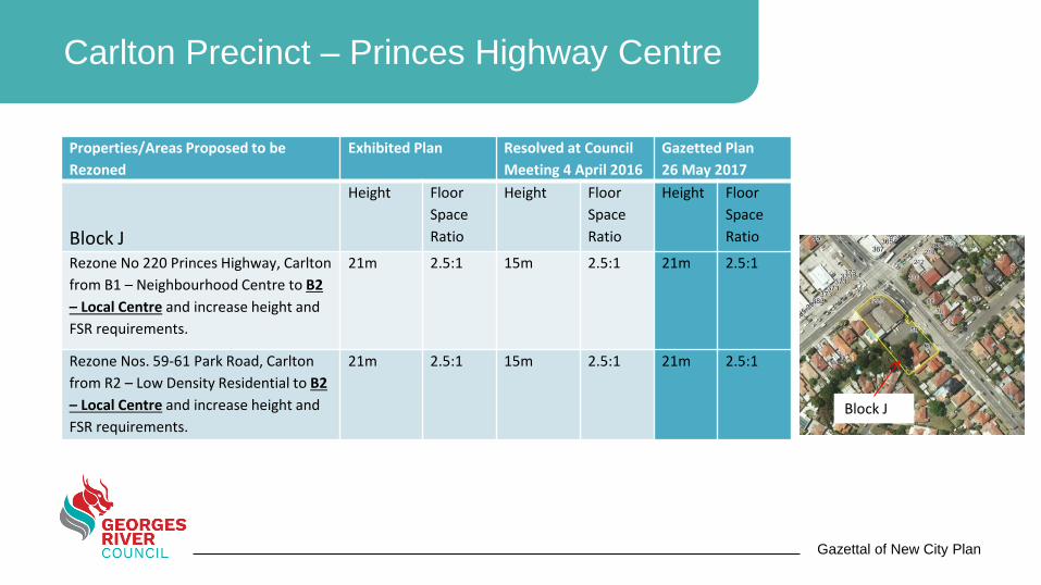
Block J
Height
Floor Space Ratio
Height Floor Space Ratio
Height Floor Space Ratio
Rezone No 220 Princes Highway, Carlton from B1 – Neighbourhood Centre to B2 – Local Centre and increase height and FSR requirements.
21m 2.5:1 15m
2.5:1
21m 2.5:1
Rezone Nos. 59-61 Park Road, Carlton from R2 – Low Density Residential to B2 – Local Centre and increase height and FSR requirements.
21m 2.5:1 15m
2.5:1
21m 2.5:1
Block J
Gazettal of New City Plan
Carlton Precinct – Princes Highway Centre
Properties/Areas Proposed to be Rezoned
Exhibited Plan Resolved at Council Meeting 4 April 2016
Gazetted Plan 26 May 2017
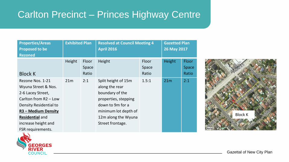
Block K
Height
Floor Space Ratio
Height Floor Space Ratio
Height Floor Space Ratio
Rezone Nos. 1-21 Wyuna Street & Nos. 2-6 Lacey Street, Carlton from R2 – Low Density Residential to R3 – Medium Density Residential and increase height and FSR requirements.
21m 2:1 Split height of 15m along the rear boundary of the properties, stepping down to 9m for a minimum lot depth of 12m along the Wyuna Street frontage.
1.5:1
21m 2:1
Block K
Gazettal of New City Plan
Carlton Precinct – Princes Highway Centre
Block L
Block M
Gazettal of New City Plan
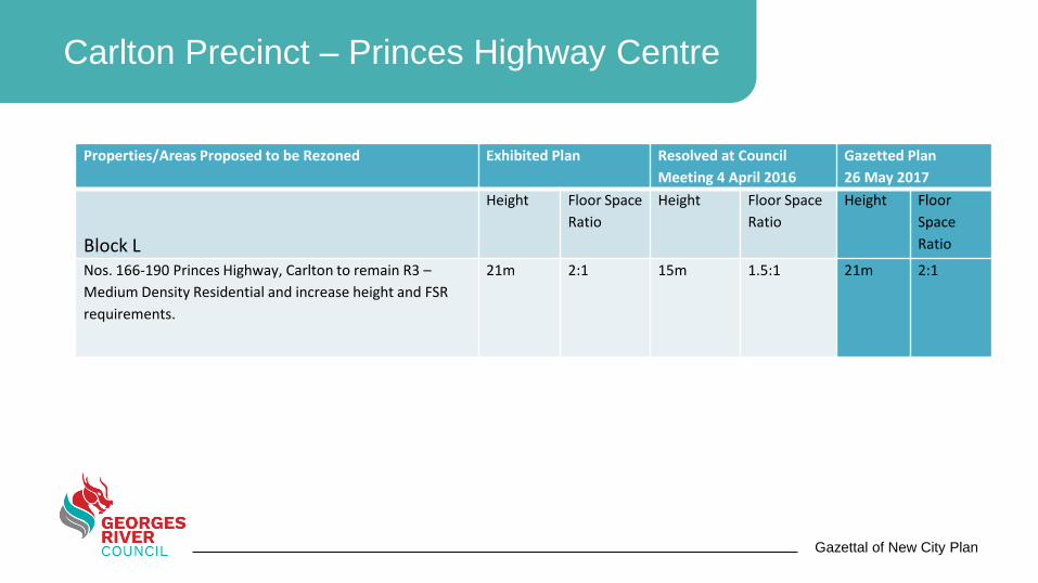
Carlton Precinct – Princes Highway Centre
Properties/Areas Proposed to be Rezoned Exhibited Plan Resolved at Council Meeting 4 April 2016
Gazetted Plan 26 May 2017
Block L
Height
Floor Space Ratio
Height Floor Space Ratio
Height Floor Space Ratio
Nos. 166-190 Princes Highway, Carlton to remain R3 – Medium Density Residential and increase height and FSR requirements.
21m 2:1 15m
1.5:1
21m 2:1
Gazettal of New City Plan
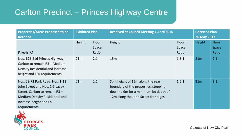
Carlton Precinct – Princes Highway Centre
Properties/Areas Proposed to be Rezoned
Exhibited Plan Resolved at Council Meeting 4 April 2016 Gazetted Plan 26 May 2017
Block M
Height
Floor Space Ratio
Height Floor Space Ratio
Height Floor Space Ratio
Nos. 192-216 Princes Highway, Carlton to remain R3 – Medium Density Residential and increase height and FSR requirements.
21m 2:1 15m
1.5:1
21m 2:1
Nos. 68-72 Park Road, Nos. 1-13 John Street and Nos. 1-5 Lacey Street, Carlton to remain R3 – Medium Density Residential and increase height and FSR requirements.
21m 2:1 Split height of 15m along the rear boundary of the properties, stepping down to 9m for a minimum lot depth of 12m along the John Street frontages.
1.5:1 21m 2:1
Gazettal of New City Plan
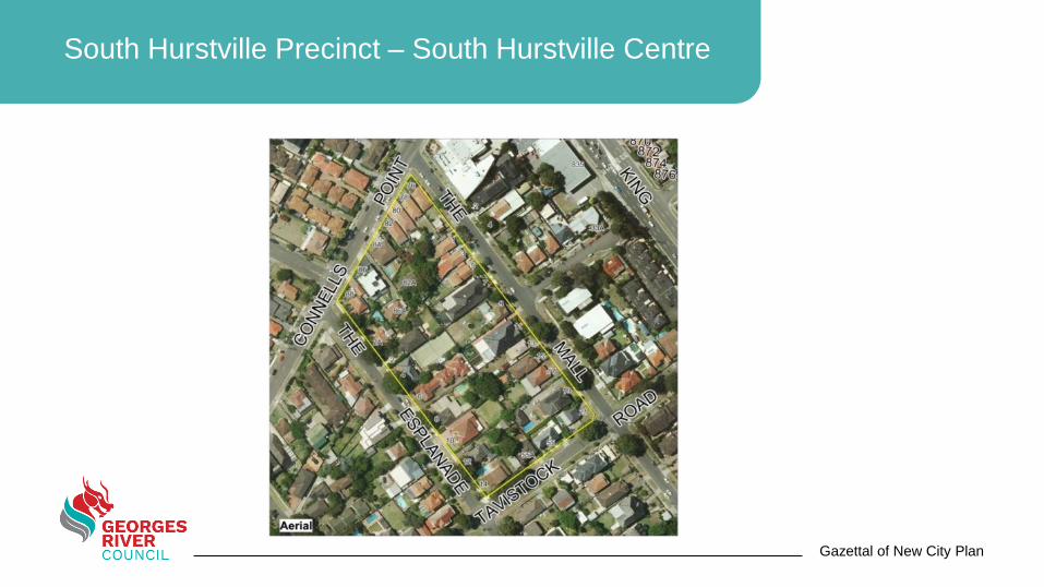
South Hurstville Precinct – South Hurstville Centre
Gazettal of New City Plan

Name of document
South Hurstville Precinct – South Hurstville Centre
Properties/Areas Proposed to be Rezoned
Exhibited Plan Resolved at Council Meeting 4 April 2016
Gazetted Plan 26 May 2017
Land use zone
Height
Floor Space Ratio
Land use zone
Height Floor Space Ratio
Land use zone
Height Floor Space Ratio
Rezone Nos. 76-86A Connells Point Road, Nos. 1-21 The Mall, Nos. 55-55A Tavistock Road, and Nos. 2-14 The Esplanade, South Hurstville from R2 – Low Density Residential to R3 – Medium Density Residential and include height and FSR requirements.
R3 12m
1:1
R2 9m
0.55:1
R3 12m 1:1
Nos. 88 Connells Point Road and No. 2A The Esplanade, South Hurstville to remain R3- Medium Density Residential and increase height and FSR requirements.
R3 12m 1:1 R3 9m
0.7:1
R3 12m 1:1
(Resolved: rezoning not to proceed. R2 – Low Density Residential to remain)
Gazettal of New City Plan
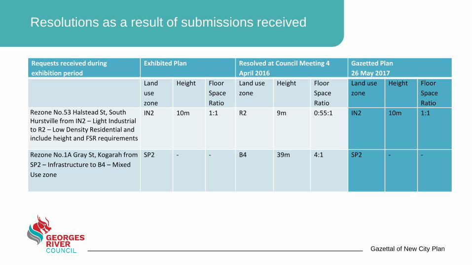
Resolutions as a result of submissions received
Requests received during exhibition period
Exhibited Plan Resolved at Council Meeting 4 April 2016
Gazetted Plan 26 May 2017
Land use zone
Height
Floor Space Ratio
Land use zone
Height Floor Space Ratio
Land use zone
Height Floor Space Ratio
Rezone No.53 Halstead St, South Hurstville from IN2 – Light Industrial to R2 – Low Density Residential and include height and FSR requirements
IN2 10m 1:1 R2 9m 0:55:1 IN2 10m 1:1
Rezone No.1A Gray St, Kogarah from SP2 – Infrastructure to B4 – Mixed Use zone
SP2 - - B4 39m 4:1 SP2 - -