structure of an early oceanic rift in the northern red...
TRANSCRIPT
______________________________________ o_c_EA __ N_O_L_O_G_IC_A __ A_C_T_A_1_9_9_0_-_v_o_L_._1_3_-_N_._2 __ ~~-----
Structure of an early oceanic rift in the N orthe rn Red Sea
Mer Rouge, Région nord,
Fosse Mabahiss, Structures superficielles,
Rift océanique.
Northem Red Sea, Mabahiss Deep,
Basaltic crust, Superficial structures,
Oceanic rift
ABSTRACT
RÉSUMÉ
Pol GUENNOC a, Guy PAUTOT b, Marie-Françoise LE QENTREC b and Alain COUTELLE c
GIS Océanologie et Géodynamique: a B.R.G.M. , B.P. n· 70, 29280 Plouzané *, France. b IFREMER, DERO/GM, B.P. n· 70, 29280 Plouzané, France. c UBO, Département des Sciences de la Terre, Avenue Le Gorgeu, 29283 Brest, France. * Now at: BRGM, B.P. n· 6009, 45060 Orléans- Cedex 2, France.
Received 28/4/88, in revised form 12/10/89, accepted 17/ 10/89.
Detailed multi-beam bathymetry and geophysical surveys in the Northern Red Sea (25• -26•N area) reveal the complex structure of a large isolated rift zone, the Mabahiss Deep, located near the Arabian continental margin. Morphological characteristics and superficial structures point to a complex interfingering of shallow, locally voluminous, basaltic rocks with Miocene evaporites and PlioQuaternary sediments of very different thickness. Sedimentary units are deformed by various types of tectonism (salt diapirism and flowage, faulting, folding ... ). An evolutionary scheme is proposed which takes into account superficial structures and magnetic anomalies. It assumes that shallow magmatism was initiated very early in Pliocene times along a transverse zone of weakness whose extent and origin are uncertain. Extension of the early volcanic zone then occurred during a succession of magmatic and tectonic phases. Ultra-slow (about 0.5 cmjyear) sea-floor spreading zones such as the Mabahiss Deep are characterized by important magmatic and tectonic events much less regularly distributed in time (long cycles) than faster oceanic spreading centres.
Oceanologica Acta, 1990. 13, 2, 145-157.
Structure d'un rift océanique dans la région nord de la mer Rouge
Des levés géophysiques et de bathymétrie SEABEAM détaillés, réalisés dans la région nord de la mer Rouge (25 à 26.N) ont permis de cartographier les structures complexes d'un rift axial (la fosse Mabahiss) située au pied de la marge arabe. Les caractères morphologiques et les structures superficielles résultent d'une juxtaposition complexe des évaporites miocènes, des sédiments Plioquaternaires d'épaisseur très variable et d'un magmatisme basaltique très volumineux par endroits. Les unités sédimentaires sont déformées par des tectoniques variées: fluage et diapirisme salifère, fractures, déformations souples ... A partir de l'analyse des structures superficielles, de la distribution des anomalies magnétiques et de leur modélisation, un schéma d'évolution est proposé. Il suppose l'initiation d'un volcanisme peu profond au début du Pliocène le long d'une zone transverse dont l'origine et l'extension sont discutées. Lors des stades ultérieurs, cette zone de volcanisme s'est agrandie au cours de phases tectoniques et volcaniques successives. Les zones d'accrétion océaniques très lentes (demi-taux: 0,5 cm/an) telles que la fosse Mabahiss sont caractérisées par de grands événements magmatiques et tectoniques beaucoup plus épisodiques que dans les centres d'accrétion plus rapides. ·
Oceanologica Acta, 1990. 13, 2, 145-157.
0399-1784/90/02 145 13/$ 3.30/© Gauthier-Villars 145
2
P. GUENNOC et al.
INTRODUCTION
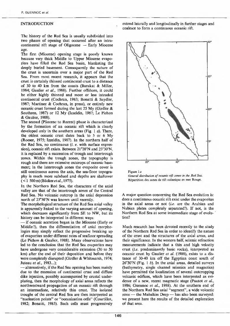
The history of the Red Sea is usually subdivided into two phases of opening that occurred after an intracontinental rift stage of Oligocene - Early Miocene age. The first (Miocene) opening stage is poorly known because very thick Middle to Upper Miocene evaporites have filled the Red Sea basin, blanketing the deeply buried basement. Consequently the nature of the crust is uncertain over a major part of the Red Sea. From most recent research, it appears that the crust is certainly thinned continental crust to a distance of 30 to 40 km from the coasts (Barakat & Miller, 1984; Gaulier et al., 1988). Further offshore, it could be either highly thinned and more or less intruded continental crust (Cochran, 1983; Bonatti & Saydler, 1987; Martinez & Cochran, in press), or entirely new oceanic crust formed during the last 25 My (Girdler & Southren, 1987) or 12 My (Izzeldin, 1987; Le Pichon & Gautier, 1988). The second (Pliocene to Recent) phase is characterized by the formation of an oceanic rift which is clearly developed only in the southern areas (Fig. 1 a). There, the oldest oceanic crust dates back to 5 or 6 My (Roeser, 1975; Izzeldin, 1987). In the northern half of the Red Sea, no continuous (i. e. with surface expression), oceanic rift exists. Between 21"20'N and 23.30'N, it is replaced by a succession of trough and intertrough zones. Within the trough zones, the topography is rough and there are extensive outcrops of oceanic basement; in the intertrough zones the evaporite cover is still continuous across the axis, the sea-floor topography is much more subdued and depths are shallower ( < 1 500m)(Backeretal., 1975). In the Northern Red Sea, the characters of the axial valley are that of the intertrough zones of the Central Red Sea. No volcanic outcrop in the axial depression north of 23.30'N was known until recently. The morphological structure of the Red Sea axial valley is apparently linked to the varying amount of opening, which decreases significantly from SE to NW, but its history can be interpreted in different ways: - if oceanic accretion began in the Miocene (Early or Middle?), th en the differentiation of axial morphologies may simply reflect the progressive breaking up of evaporites under different rates of seafloor spreading (Le Pichon & Gautier, 1988). Many observations have led to the conclusion that the Red Sea evaporites may have undergone very considerable extension (30 to 50 km) after the end of their deposition and before they were completely disrupted (Girdler & Whitmarsh, 1974; Juteau et al., 1983 ... ); -alternative! y, if the Red Sea opening has been main! y due to the extension of continental crust and diffuse dike injection, possibly accompanied by crustal underplating, then the morphology of axial areas reflects the northwestward propagation of an oceanic rift through an intermediate, relatively thin crust. The isolated troughs of the central Red Sea are then interpreted as "nucleation points" or "oceanization cells" (Courtillot, 1982; Bonatti, 1985). Such cells must progressively
146
extend laterally and longitudinally in further stages and coalesce to form a continuous oceanic rift.
Figure 1 a General distribution of oceanic rift zones in the Red Sea. Répartition des zones de rift océanique en mer Rouge.
A major question concerning the Red Sea evolution is: does a continuous oceanic rift exist under the evaporites in the axial areas or not (i.e. are the Arabian and Nubian plates completely separated?). If not, is the Northern Red Sea at sorne intermediate stage of evolu- · ti on?
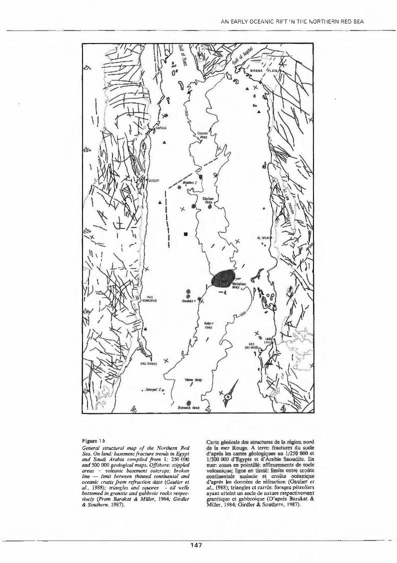
Much research has been devoted recently to the study of the Northern Red Sea in order to identify the nature of the crust and the structures of the axial areas, and their significance. In the western half, seismic refraction measurements indicate that a thin and high velocity crust (i.e. predominantly basic rocks), interpreted as oceanic crust by Gautier et al. (1988), exists to a distance of 30-40 km off the Egyptian coast south of 26.30'N (Fig. 1 b). In the axial areas, detailed surveys (bathymetry, single channel seismics and magnetics) have permitted the localization of severa! outcropping volcanic edifices, which have been interpreted as evidence of a new, recent magmatic stage (Pautot et al., 1986; Guennoc et al., 1988). At the southern end of the Northern Red Sea axial "segment", a wide volcanic zone - the Mabahiss Deep - has also been surveyed: we present here the results of the detailed exploration of that area.
Vemo deep
1 , labm(«/L t>
? • 80llno<k dtep
Figure 1 b General structural map of the Northern Red Sea. On land: basementfracture trends in Egypt and Saudi Ar abia compiled from 1: 250 000 and 500 000 geological maps. Offshore: stippled areas - volcanic basement outcrops; broken fine - limit between thinned continental and oceanic crusts from refraction data (Gautier et al., 1988); triangles and squares - oil wells bottomed in granitic and gabbroic rocks respective/y (From Barakat & Miller, 1984; Girdler & Southern, 1987).
147
AN EARL Y OCEANIC RIFT IN THE NORTHERN RED SEA
~1
Carte générale des structures de la région nord de la mer Rouge. A terre: fractures du socle d'après les cartes géologiques au l /250 000 et 1/500 000 d'Egypte et d'Arabie Saoudite. En mer: zones en pointillé: affieureme.nts de socle volcanique; ligne en tireté: limite entre croûte continentale amincie et croùte océanique d'après les données de réfraction (Gautier et al. , 1988); triangles et carrés: forages pétroliers ayant atteint un socle de nature respectivement granitique et gabbroique (D'apr~s Barakat & Miller, 1984; Girdler & Southerri, 1987).
P. GUENNOC et al
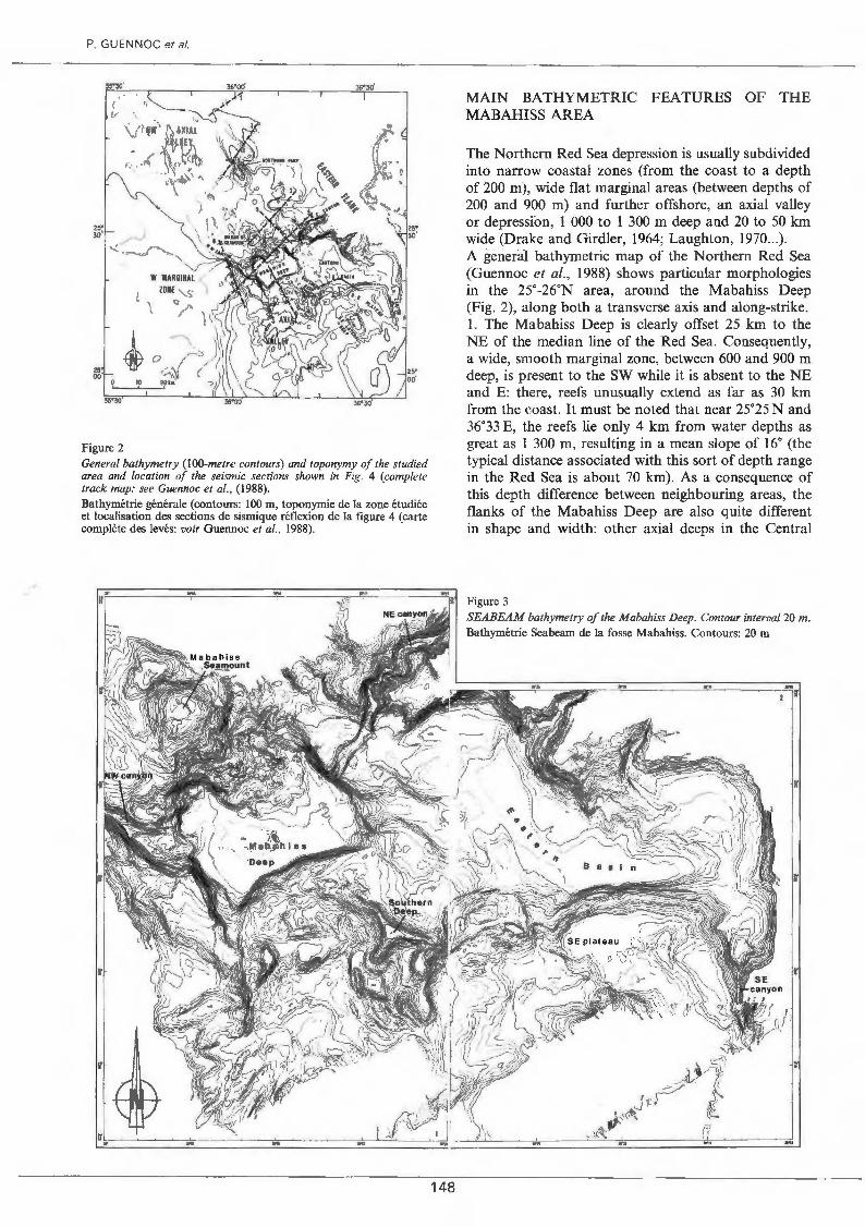
Figure 2 General bathymetry (lOO-metre contours) and toponymy of the studied area and location of the seismic sections shown in Fig. 4 (complete track map: see Guennoc et al., (1988). Bathymétrie générale (contours: 100 rn, toponymie de la zone étudiée et localisation des sections de sismique réflexion de la figure 4 (carte complète des levés: voir Guennoc et al., 1988).
148
MAIN BATHYMETRie FEATURES OF THE MABAHISS AREA
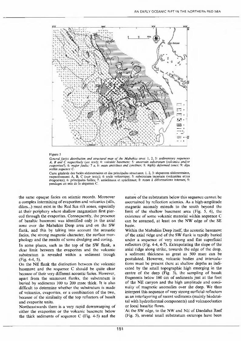
The Northern Red Sea depression is usually subdivided into narrow coastal zones (from the coast to a depth of 200 m), wide flat marginal areas (between depths of 200 and 900 rn) and further offshore, an axial valley or depression, 1 000 to 1 300 rn deep and 20 to 50 km wide (Drake and Girdler, 1964; Laughton, 1970 ... ). A general bathymetrie map of the Northern Red Sea (Guennoc et al., 1988) shows particular morphologies in the 25"-26•N area, around the Mabahiss Deep (Fig. 2), along both a transverse axis and along-strike. 1. The Mabahiss Deep is clearly offset 25 km to the NE of the median line of the Red Sea. Consequently, a wide, smooth marginal zone, between 600 and 900 rn deep, is present to the SW while it is absent to the NE and E: there, reefs unusually extend as far as 30 km from the coast. lt must be noted that near 25•25 N and 36.33 E, the reefs lie only 4 km from water depths as great as 1 300 rn, resulting in a mean slope of 16. (the typical distance associated with this sort of depth range in the Red Sea is about 70 km). As a consequence of this depth difference between neighbouring areas, the flanks of the Mabahiss Deep are also quite different in shape and width: other axial deeps in the Central
Figure 3 SEABEAM bathymetry of the Mabahiss Deep. Contour interva/20 m. Bathymétrie Seabeam de la fosse Mabahiss. Contours: 20 m.
Red Sea such as the Atlantis II or Nereus deeps present much greater symmetry (Pautot, 1983). 2. (a) The morphology of the NW axial valley is typical of the Northern Red Sea (Guennoc et al., 1988) except for an elongated trough (Northern Deep, maximum depth: 1 720 rn) on the eastern border. The transition between the NW axial valley and the Mabahiss Deep is rather sharp. They are separated by only a small (1 400 rn) arcuate depression bordering the large subcircular Mabahiss Seamount. This seamount with a summit 4-5 km wide at -880 rn, is a most unusual feature along the Red Sea axis. (b) Southwestwards, there exists a rapid deepening from the seamount to the Mabahiss Deep, which is a large (15 x 9 km), 2 180 rn deep depression. The depth and width of this deep are quite similar to those of the Nereus Deep, while the Atlantis II Deep is much narrower (6 km). (c) Further south there is a wide and complex transition zone between two axial "segments" of very different trends: to the south the axial zone intermediate between the Central and Northern Red Sea trends N-S while the NW axial valley trends N140oE (Fig. 1 b). The major features of this transition area, the Southern axial valley and SE areas (Fig. 2), are: (1) a significant widening of the area deeper than 1 000 rn, the 1 000 rn isobath being much offset to the ENE between 25°00 and 25°30 N: (2) large, flat structures such as the SE plateau and the Eastern Basin, (3) a complex Southern axial valley delimited by the 1 500 rn contours. The SEABEAM map (Fig. 3) reveals greater detail and clearly displays the juxtaposition of the following, very different, morpho-structural domains: 1. the flat Eastern Basin, 1 720 rn deep, is composed of two distinct branches trending NNW -SSE and E-W respectively; 2. the Southern axial valley is made up of a complex, convolute pattern, of ridges and troughs or valleys, at depths of 1 700 to 1 900 rn, in the area of the 2 120 rn Southern Deep. The Southern Deep is formed of three arms and its shape is rather typical of small intraevaporite deeps (ex. Kebrit deep, Biicker et al., 1975; Pautot, 1983). More linear NNE-SSW trending ridges are located to the SE; 3. the Mabahiss Deep shows a clear asymmetry, as the deepest part is located to the west while the axial ridge (i.e. the S flank of the Seamount) is offset to the northeast; 4. severa! important canyons or valleys, very different in shape, open into the trough. A high detrital input of sediment must transit through these pathways from neighbouring areas towards the Mabahiss Deep. Despite this supposed high sedimentation rate, a small topographie high emerges 75 rn above the flat seafloor of the deep. In conclusion, when compared with other parts of the axial Red Sea rift, the Mabahiss area presents similar maximum depths but many differences both in the axial structures (a .wide, asymmetric axial deep and a wide seamount) and in the morphology of the flanks or of the neighbouring areas.
AN EARL Y OCEANIC RIFT IN THE NORTHERN RED SEA
These morphological characteristics reflect differences in superficial structures that have been investigated by single-channel seismic reflection.
NATURE AND DISTRIBUTION OF ACOUSTIC SEQUENCES
Sediments
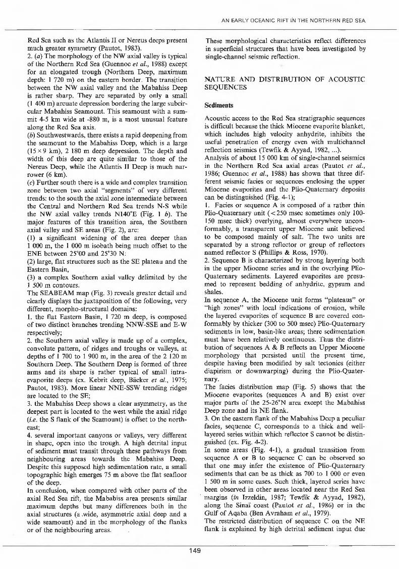
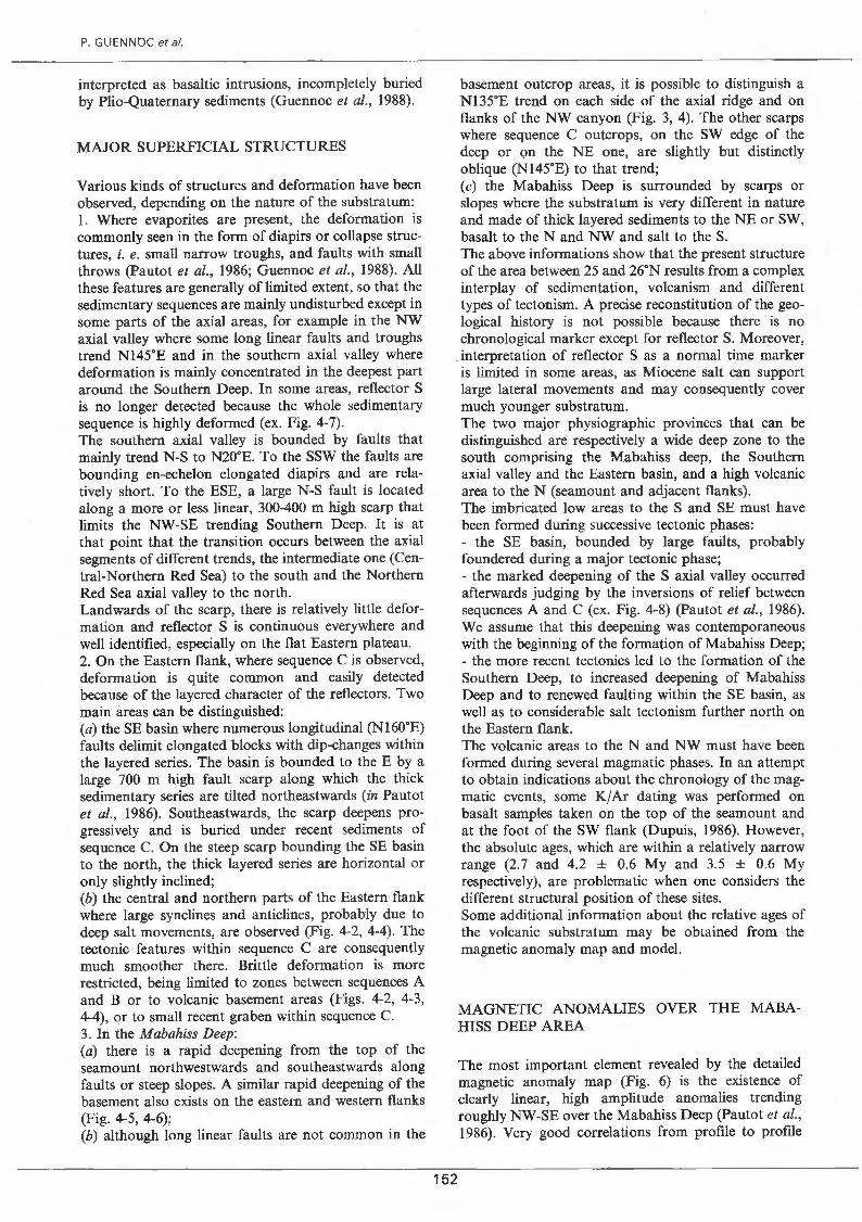
Acoustic access to the Red Sea stratigraphie sequences is difficult because the thick Miocene evaporite blanket, which includes high velocity anhydrite, inhibits the useful penetration of energy even with multichannel reflection seismics ~Tewfik & Ayyad, 1982, ... ). Analysis of about 15 000 km of single-channel seismics in the Northern Red Sea axial areas (Pautot et al., 1986; Guennoc et al., 1988) has shown that three different seismic facies or sequences enclosing the upper Miocene evaporites and the Plio-Quaternary deposits can be distinguished (Fig. 4-1); 1. Facies or sequence A is composed of a rather thin Plio-Quaternary unit ( <250 msec sometimes only 100-150 msec thick) overlying, a1most everywhere unconformably, a transparent upper Miocene unit believed to be composed mainly of salt. The two units are separated by a strong reflector or group of reflectors named reflector S (Phillips & Ross, 1970). 2. Sequence B is characterized by strong 1ayering both in the upper Miocene series and in the overlying PlioQuaternary sediments. Layered evaporites are presumed to represent bedding of anhydrite, gypsum and shales. In sequence A, the Miocene unit forms "plateaus" or "high zones" with local indications of erosion, while the layered evaporites of sequence B are covered conformably by thicker (300 to 500 msec) Plio-Quaternary sediments in low, basin-like areas; there sedimentation must have been relatively continuous. Thus the distribution of sequences A & B reflects an Upper Miocene morphology that persisted until the present time, despite having been modified by salt tectonics (either diapirism or downwarping) during the P1io-Quaternary. The facies distribution map (Fig. 5) shows that the Miocene evaporites (sequences A and B) exist over major parts of the 25-26oN area except the Mabahiss Deep zone and its NE flank. 3. On the eastern flank of the Mabahiss Deep a peculiar facies, sequence C, corresponds to a thick and welllayered series within which reflector S cannot be distinguished (ex. Fig. 4-2). In sorne areas (Fig. 4-1), a graduai transition from sequence A or B to sequence C can be observed so that one may infer the existence of Plio-Quaternary sediments that can be as thick as 700 to 1 000 or even 1 500 rn in sorne cases. Such thick, layered series have been observed in other areas located near the Red Sea
· margins (in Izzeldin, 1987; Tewfik & Ayyad, 1982), along the Sinaï coast (Pautot et al., 1986) or in the Gulf of Aqaba (Ben Avraham et al., 1979).
149
The restricted distribution of sequence C on the NE flank is explained by high detrital sediment input due
P. GUENNOC et al.
to the proximity of the Arabian margin and to a wide reef zone. Indeed, sedimentation rates as high as 500 rn/My or even 900 mjMy have been measured in recent biodetrital deposits drilled in the narrow axial valley of the Southern Red Sea (site 229, in Whitmarsh et al., 1974). These thick series cover almost the whole eastern flank of the axial zone from 25 to 26.N. They are observed in the zone between the very edge of the Mabahiss Deep and the reef areas, but northwestwards sequence C pinches out progressively south of 26.N. To the south, the boundary of sequence C is offset along the edge of the SE plateau. In this area a small isolated zone with a thick layered series is observed in the west but, curiously, it is not localized within the SE lateral deep but is found just to the east of it.
1
2
3
--·
150
wsw
4
SW flank volconîc bosement
ENE NW
Figure 4-1 to 4-8
SE
Single channel seismic profiles of the Mabahiss deep area (location shown on Figure 3). Vertical sca/e in seconds two way travel lime, S = rejlector S (Miocene-Pliocene boundary). Profils de sismique réflexion monotrace dans le secteur de la fosse Mabahiss. Localisation: voir la figure 4. Échelle verticale en secondes temps double. S = réflecteur S (limite Miocène-Pliocène).
In the central part of eastern flank of Mabahiss Deep, a reduced Plio-Quaternary sedimentation (sequence A) is observed in well-restricted and isolated zones and to the NE of the axial seamount (Fig. 4-3, 5). At the SW edge of the deep, layered Plio-Quaternary sediments (sequence C) are restricted to a small area on the deeper step of the SW flank.
The volcanic basement
The presence of volcanic basement in the Red Sea is clearly recognized only when it is outcropping or nearly outcropping. In sorne areas the nature of the basement cannot be ascertained and a mixed composition (volcanics and evaporites) may weil be surmised. Indeed, the salt unit and the basait may both present
6
7
8
AN EARL Y OCEANIC RIFT IN THE NORTHERN RED SEA
10 ,., .. " f~~.
l, 1\l) ' r~
/} c& ..
' · "' .J1
Figure 5 General facies distribution and structural map of the Mabahiss area: 1, 2, 3: sedimentary sequences A, B and C respectively (see text); 4: volcanic basement; 5: uncertain substratum (volcanics and/or evaporites?); 6: major jaults; 7 a, b: main anticlines and synclines; 8: highly deformed zones; 9: dips within sequence C. Carte générale des faciès sédimentaires et des principales structures; 1, 2, 3: séquences sédimentaires, respectivement A, B, C (voir texte); 4: socle volcanique; 5: substratum incertain (volcanites et/ou évaporites); 6: principales failles; 7: anticlinaux et synclinaux; 8: zones à déformations intenses; 9: pendages au sein de la séquence C.
the same opaque facies on seismic records. Moreover a complex intermixing of evaporites and volcanics (sills, dikes ... ) must exist in the Red Sea rift zones, especially at their periphery where shallow magmatism first pierced through the evaporites. Consequently, the presence of basaitic basement was identified only in the axial zone over the Mabahiss Deep area and on the SW flank, and this by taking into account the acoustic facies, the strong magnetic character, the surface morphology and the resuits of sorne dredging and coring. In sorne places, such as the top of the SW flank, a clear limit between the evaporites and the volcanic substratum is revealed within a sediment trough (Fig. 4-4, 5). On the NE flank the distinction between the volcanic basement and the sequence C should be quite clear because of their very different acoustic facies. However, apart from the seamount flanks, the substratum is buried by sediments 100 to 200 msec thick. It is also difficuit to determine whether the substratum is made of volcanics, evaporites, or a combination of the two, because of the similarity of the top reflectors of basait and evaporite units. Northeastwards there is a very rapid downwarping of either the evaporites or the volcanic basement below the thick sediments of sequence C (Fig. 4-5) and the
151
nature of the substratum below this sequence cannot be ascertained by reflection seismics. As a high-amplitude magnetic anomaly extends to the south beyond the limit of the shallow basement area (Fig. 5, 6), the existence of sorne volcanic material within sequence C can be assumed, at least on the NW edge of the SE basin. Within the Mabahiss Deep itself, the acoustic basement of the axial ridge and of the SW flank is rapidly buried under a sequence of very strong and flat superficial reflectors (Fig. 4-4, 4-7). Extrapolating the slope of the axial ridge along strike, towards the edge of the deep, a sediment thickness as great as 500 msec can be postulated. However, volcanic bodies and intercalations must be present there at shallow depths as indicated by the small topographie high emerging in the centre of the deep (Fig. 3), the sampling of basait fragments below 160 cm of sediments just at the foot of the NE canyon and the high amplitude and continuity· of magnetic anomalies over the deep. We thus interpret this sequence of very strong surficial reflectors as an interlayering of recent sediments (mainly biodetrital with hydrothermal components) and volcanoclastics or local basaltic flows. "At the SW edge, to the NW and NE of Daedalus Reef (Fig. 5), severa! small substratum outcrops have been
P. GUENNOC et al.
interpreted as basaltic intrusions, incompletely buried by Plio-Quaternary sediments (Guennoc et al., 1988).
MAJOR SUPERFICIAL STRUCTURES
Various kinds of structures and deformation have been observed, depending on the nature of the substratum: 1. Where evaporites are present, the deformation is commonly seen in the form of diapirs or collapse structures, i. e. small narrow troughs, and faults with small throws (Pautot et al., 1986; Guennoc et al., 1988). Ail these features are generally of limited extent, so that the sedimentary sequences are mainly undisturbed except in sorne parts of the axial areas, for example in the NW axial valley where sorne long linear faults and troughs trend N145oE and in the southern axial valley where deformation is mainly concentrated in the deepest part around the Southern Deep. In sorne areas, reflector S is no longer detected because the whole sedimentary sequence is highly deformed (ex. Fig. 4-7). The southern axial valley is bounded by faults that mainly trend N-S to N20°E. To the SSW the faults are bounding en-echelon elongated diapirs and are relatively short. To the ESE, a large N-S fault is located along a more or less linear, 300-400 m high scarp that limits the NW-SE trending Southern Deep. It is at that point that the transition occurs between the axial segments of different trends, the intermediate one (Central-Northern Red Sea) to the south and the Northern Red Sea axial valley to the north. Landwards of the scarp, there is relatively little deformation and reflector S is continuons everywhere and well identified, especially on the flat Eastern plateau. 2. On the Eastern flank, where sequence C is observed, deformation is quite common and easily detected because of the layered character of the reflectors. Two main areas can be distinguished: (a) the SE basin where numerous longitudinal (N160oE) faults delimit elongated blocks with dip-changes within the layered series. The basin is bounded to the E by a large 700 m high fault scarp along which the thick sedimentary series are tilted northeastwards (in Pautot et al., 1986). Southeastwards, the scarp deepens progressively and is buried under recent sediments of sequence C. On the steep scarp bounding the SE basin to the north, the thick 1ayered series are horizontal or only slightly inclined; (b) the central and northern parts of the Eastern flank where large synclines and anticlines, probably due to deep salt movements, are observed (Fig. 4-2, 4-4). The tectonic features within sequence C are consequently rouch smoother there. Brittle deformation is more restricted, being limited to zones between sequences A and B or to volcanic basement areas (Figs. 4-2, 4-3, 4-4), or to small recent graben within sequence C. 3. In the Mabahiss Deep: (a) there is a rapid deepening from the top of the seamount northwestwards and southeastwards along faults or steep slopes. A similar rapid deepening of the basement also exists on the eastern and western flanks (Fig. 4-5, 4-6); (b) although long linear faults are not common in the
basement outcrop areas, it is possible to distinguish a Nl35oE trend on each side of the axial ridge and on flanks of the NW canyon (Fig. 3, 4). The other scarps where sequence C outcrops, on the SW edge of the deep or on the NE one, are slightly but distinctly oblique (Nl45oE) to that trend; (c) the Mabahiss Deep is surrounded by scarps or slopes where the substratum is very different in nature and made of thick layered sediments to the NE or SW, basait to the N and NW and salt to the S. The above informations show that the present structure of the area between 25 and 26°N results from a complex interplay of sedimentation, volcanism and different types of tectonism. A precise reconstitution of the geological history is not possible because there is no chronological marker except for reflector S. Moreover,
. interpretation of reflector S as a normal time marker is limited in sorne areas, as Miocene salt can support large lateral movements and may consequently cover much younger substratum.
152
The two major physiographic provinces that can be distinguished are respectively a wide deep zone to the south comprising the Mabahiss deep, the Southern axial valley and the Eastern basin, and a high volcanic area to the N (seamount and adjacent flanks). The imbricated low areas to the S and SE must have been formed during successive tectonic phases: - the SE basin, bounded by large faults, probably foundered during a major tectonic phase; - the marked deepening of the S axial valley occurred afterwards judging by the inversions of relief between sequences A and C (ex. Fig. 4-8) (Pautot et al. , 1986). We assume that this deepening was contemporaneous with the beginning of the formation of Mabahiss Deep; - the more recent tectonics led to the formation of the Southern Deep, to increased deepening of Mabahiss Deep and to renewed faulting within the SE basin, as well as to considerable salt tectonism further north on the Eastern flank. The volcanic areas to the N and NW must have been formed during severa! magmatic phases. In an attempt to obtain indications about the chronology of the magmatie events, sorne K/Ar dating was performed on basait samples taken on the top of the seamount and at the foot of the SW flank (Dupuis, 1986). However, the absolute ages, which are within a relatively narrow range (2.7 and 4.2 ± 0.6 My and 3.5 ± 0.6 My respectively), are problematic when one considers the different structural position of these sites. Sorne additional information about the relative ages of the volcanic substratum may be obtained from the magnetic anomaly map and model.
MAGNETIC ANOMALIES OVER THE MABAHISS DEEP AREA
The most important element revealed by the detailed magnetic anomaly map (Fig. 6) is the existence of clearly linear, high amplitude anomalies trending roughly NW-SE over the Mabahiss Deep (Pautot et al., 1986). Very good correlations from profile to profile
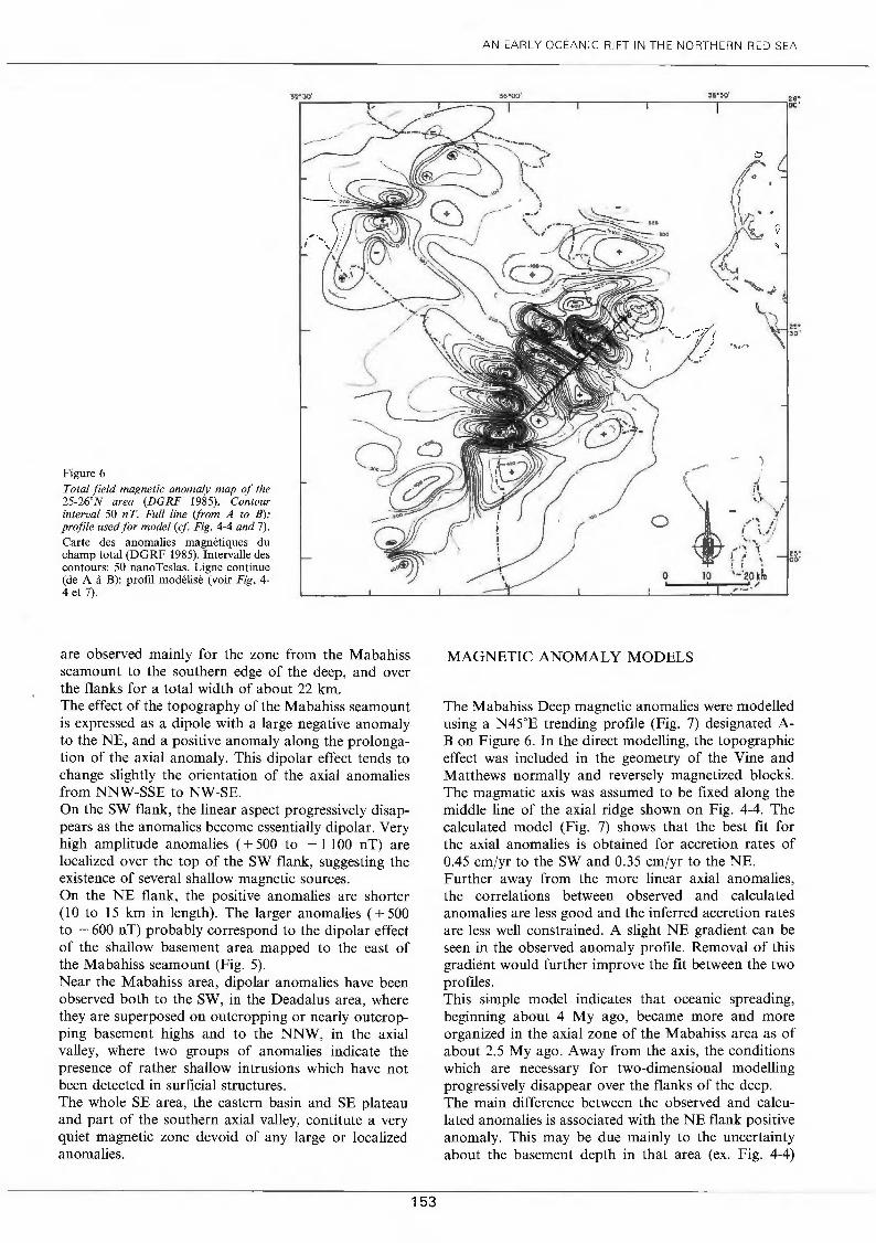
Figure 6 Total field magne tic anomaly map of the 25-26oN area (DGRF 1985). Contour interval 50 nT. Full fine (from A to B): profile usedfor mode! (cf Fig. 4-4 and 7).
Carte des anomalies magnétiques du champ total (DGRF 1985). Intervalle des contours: 50 nanoTeslas. Ligne continue (de A à B): profil modélisé (voir Fig. 4-4 et 7) .
are observed mainly for the zone from the Mabahiss seamount to the southern edge of the deep, and over the flanks for a total width of about 22 km. The effect of the topography of the Mabahiss seamount is expressed as a dipole with a large negative anomaly to the NE, and a positive anomaly along the prolongation of the axial anomaly. This dipolar effect tends to change slightly the orientation of the axial anomalies from NNW-SSE to NW-SE. On the SW flank, the linear aspect progressively disappears as the anomalies become essentially dipolar. Very high amplitude anomalies ( + 500 to - 1 100 nT) are localized over the top of the SW flank, suggesting the existence of several shallow magnetic sources. On the NE flank, the positive anomalies are shorter (1 0 to 15 km in length). The larger anomalies ( + 500 to - 600 nT) probably correspond to the dipolar effect of the shallow basement area mapped to the east of the Mabahiss seamount (Fig. 5). Near the Mabahiss area, dipolar anomalies have been observed both to the SW, in the Deadalus area, where they are superposed on outcropping or nearly outcropping basement highs and to the NNW, in the axial valley, where two groups of anomalies indicate the presence of rather shallow intrusions which have not been detected in surficial structures. The whole SE area, the eastern basin and SE plateau and part of the southern axial valley, contitute a very quiet magnetic zone devoid of any large or localized anomalies.
153
AN EARL Y OCÉANIC RIFT IN THE NORTHERN RED SEA
MAGNETIC ANOMAL Y MO DELS
The Mabahiss Deep magnetic anomalies were modelled using a N45oE trending profile (Fig. 7) designated AB on Figure 6. In the direct modelling, the topographie effect was included in the geometry of the Vine and Matthews normally and reversely magnetized blockS. The magmatic axis was assumed to be fixed along the middle line of the axial ridge shown on Fig. 4-4. The calculated model (Fig. 7) shows that the best fit for the axial anomalies is obtained for accretion rates of 0.45 cm/yr to the SW and 0.35 cm/yr to the NE. Further away from the more linear axial anomalies, the correlations between observed and calculated anomalies are less good and the inferred accretion rates are less well constrained. A slight NE gradient can be seen in the observed anomaly profile. Removal of this gradient would further improve the fit between the two profiles. This simple model indicates that oceanic spreading, beginning about 4 My ago, became more and more organized in the axial zone of the Mabahiss area as of about 2.5 My ago. Away from the axis, the conditions which are necessary for two-dimensional modelling progressively disappear over the flanks of the deep. The main difference between the observed and calculated anomalies is associated with the NE flank positive anomaly. This may be due mainly to the uncertainty about the basement depth in that area (ex. Fig. 4-4)
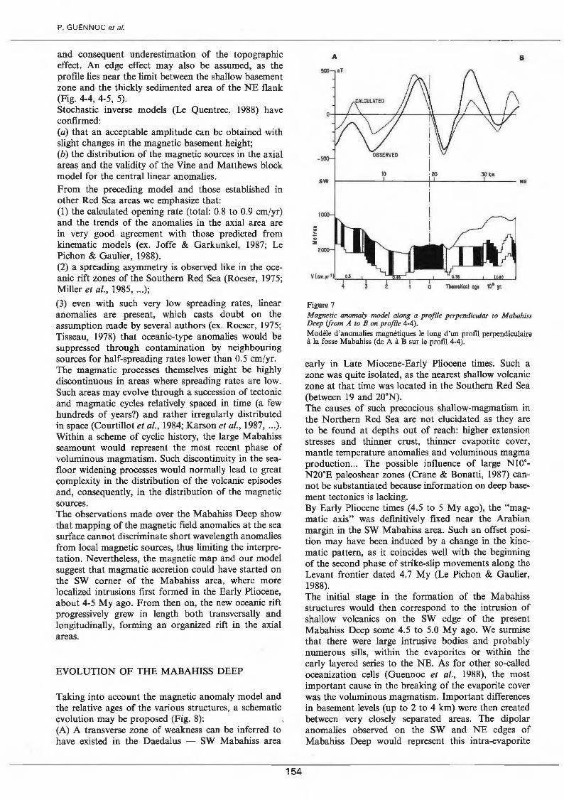
P. GUENNOC et al.
and consequent underestimation of the topographie effect. An edge effect may also be assumed, as the profile lies near the limit between the shallow basement zone and the thickly sedimented area of the NE flank (Fig. 4-4, 4-5, 5). Stochastic inverse models (Le Quentrec, 1988) have confirmed: (a) that an acceptable amplitude can be obtained with slight changes in the magnetic basement height; (b) the distribution of the magnetic sources in the axial areas and the validity of the Vine and Matthews block model for the centrallinear anomalies. From the preceding model and those established in other Red Sea areas we emphasize that: (1) the calculated opening rate (total: 0.8 to 0.9 cm/yr) and the trends of the anomalies in the axial area are in very good agreement with those predicted from kinematic models (ex. Joffe & Garkunkel, 1987; Le Pichon & Gaulier, 1988). (2) a spreading asymmetry is observed like in the oceanic rift zones of the Southern Red Sea (Roeser, 1975; Miller et al., 1985, ... );
(3) even with such very low spreading rates, linear anomalies are present, which casts doubt on the assumption made by severa! authors (ex. Roeser, 1975; Tisseau 1978) that oceanic-type anomalies would be suppres~ed through contamination by neighbouring sources for half-spreading rates lower than 0.5 cmjyr. The magmatic processes themselves might be highly discontinuous in areas where spreading rates are low. Such areas may evolve through a succession of tectonic and magmatic cycles relatively spaced in time (a few hundreds of years?) and rather irregularly distributed in space (Courtillot et al., 1984; Karson et al., 1987, ·)· Within a scheme of cyclic history, the large Mabahtss seamount would represent the most recent phase of voluminous magmatism. Such discontinuity in the seafloor widening processes would normally lead to great complexity in the distribution of the volcanic episod:s and, consequently, in the distribution of the magnettc sources. The observations made over the Mabahiss Deep show that mapping of the magnetic field anomalies at the sea surface cannot discriminate short wavelength anomalies from local magnetic sources, thus limiting the interpretation. Nevertheless, the magnetic map and our model suggest that magmatic accretion could have started on the SW corner of the Mabahiss area, where more localized intrusions first formed in the Early Pliocene, about 4-5 My ago. From then on, the new oceanic rift progressively grew in length both transversally and longitudinally, forming an organized rift in the axial areas.
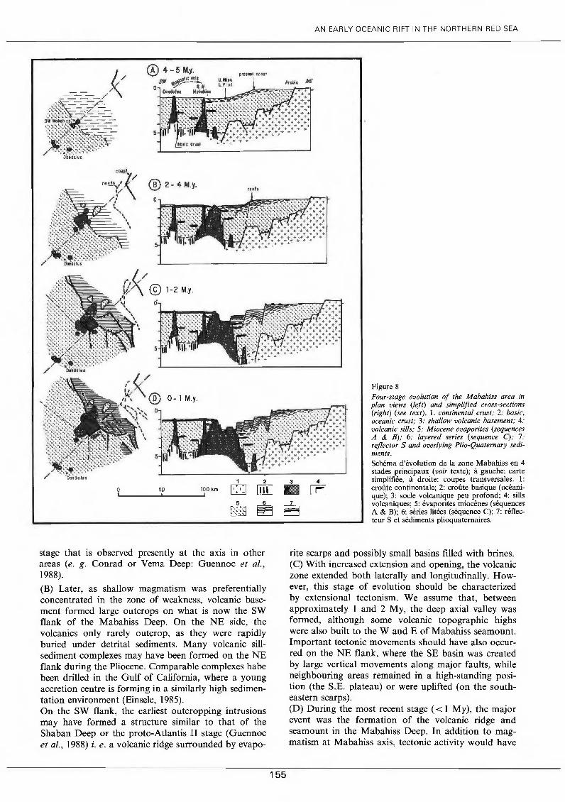
EVOLUTION OF THE MABAHISS DEEP
Taking into account the magnetic anomaly model an_d the relative ages of the various structures, a schemattc evolution may be proposed (Fig. 8): (A) A transverse zone of weakness can be inferred to have existed in the Daedalus - SW Mabahiss area
154
A B
SW
Figure 7 Magnetic anomaly mode! along a profile perpendicular to Mabahiss Deep (from A to B on profile 4-4). Modèle d'anomalies magnétiques le long d'un profil perpendiculaire à la fosse Mabahiss (de A à B sur le profil 4-4).
early in Late Miocene-Early Pliocene times. Such _a zone was quite isolated, as the nearest shallow volcamc zone at that time was located in the Southern Red Sea (between 19 and 20.N). . . The causes of such precocious shallow-magmattsm m the Northern Red Sea are not elucidated as they are to be found at depths out of reach: higher extension stresses and thinner crust, thinner evaporite cover, mantle temperature anomalies and voluminous magma production ... The possible influence of large Nto·N2o·E paleoshear zones (Crane & Bonatti, 1987) cannot be substantiated because information on deep basement tectonics is lacking. By Early Pliocene times (4.5 to 5 My ago), the "m~gmatic axis" was definitively fixed near the Arabmn margin in the SW Mabahiss area. Such an offset position may have been induced by a change in the kinematic pattern, as it coïncides weil with the beginning of the second phase of strike-slip movements along the Levant frontier dated 4.7 My (Le Pichon & Gaulier, 1988). . The initial stage in the formation of the Mabahtss structures would then correspond to the intrusion of shallow volcanics on the SW edge of the present Mabahiss Deep sorne 4.5 to 5.0 My ago. We surmise that there were large intrusive bodies and probably numerous sills, within the evaporites or within the early layered series to the NE. As for other so-called oceanization cells (Guennoc et al., 1988), the most important cause in the breaking of the evaporite cover was the voluminous magmatism. Important differences in basement levels (up to 2 to 4 km) were then created between very closely separated areas. The dipolar anomalies observed on the SW and NE edges of Mabahiss Deep would represent this intra-evaporite
@ 2- 4 M.y. ruh
AN EARL Y OCEANIC RIFT IN THE NORTHERN RED SEA
' . . . ' .. . . . . . . . . .
+ + ..... ... -T + + ... ...
' .... +- + + ... ,. .. + .. + + + ... + .... + + + .. . .
... .. ..;. + + + ... .. : -o-> >•: + > • TT .1- + + + •
@) 1-2 M.y.
f ( / /
~~ ,, , @ 0- 1 M.y. (~, ,:: ........ ',
\ ,1 .. ,
' ' ' 1
'
0 50 100 km
1 2
0 + [ill] 5 6
~ c ~
stage that is observed presently at the axis in other areas (e. g. Conrad or Vema Deep: Guennoc et al., 1988).
(B) Later, as shallow magmatism was preferentially concentrated in the zone of weakness, volcanic basement formed large outcrops on what is now the SW flank of the Mabahiss Deep. On the NE side, the volcanics only rarely outcrop, as they were rapidly buried under detrital sediments. Many volcanic sinsediment complexes may have been formed on the NE flank during the Pliocene. Comparable complexes habe been drilled in the Gulf of California, where a young accretion centre is forming in a similarly high sedimentation environment (Einsele, 1985). On the SW flank, the earliest outcropping intrusions may have formed a structure similar to that of the Shaban Deep or the proto-Atlantis II stage (Guennoc et al., 1988) i.e. a volcanic ridge surrounded by evapo-
3 • 7
ô
4
[El
Figure 8 Four-stage evolution of the Mabahiss area in plan views (left) and simplified cross-sections (right) (see text) . 1. continental crust; 2: basic, oceanic crust; 3: shallow volcanic basement; 4: volcanic sills; 5: Miocene evaporites (sequences A & B); 6: layered series (sequence C); 7: reflector S and overlying Plio-Quaternary sediments. Schéma d'évolution de la zone Mabahiss en 4 stades principaux (voir texte); à gauche: carte simplifiée, à droite: coupes transversales. 1: croûte continentale; 2: croûte basique (océanique); 3: socle volcanique peu profond; 4: sills volcaniques; 5: évaporites miocènes (séquences A & B); 6: séries litées (séquence C); 7: réflecteur S et sédiments plioquaternaires.
rite scarps and possibly small basins filled with brines. (C) With increased extension and opening, the volcanic zone extended bath laterally and longitudinally. However, this stage of evolution should be characterized by extensional tectonism. We assume that, between approximately 1 and 2 My, the deep axial valley was formed, although sorne volcanic topographie highs were also built to the W and E of Mabahiss seamount. Important tectonic movements should have also occurred on the NE flank, where the SE basin was created by large vertical movements along major faults, while neighbouring areas remained in a high-standing position (the S.E. plateau) or were uplifted (on the southeastern scarps). (D) During the most recent stage ( < 1 My), the major event was the formation of the volcanic ridge and seamount in the Mabahiss Deep. In addition to magmatism at Mabahiss axis, tectonic activity would have
155
P. GUENNOC et al.
continued in the SE basin and the southern axial valley. Considering the intense deformation in the Southern Deep area, its great depth compared to other intraevaporite troughs and the magnetic anomaly to the west, magmatic intrusions should soon break through the evaporite cover in that area. In the Mabahiss Deep, any two-dimensional scheme is oversimplified because there are important differences in basement levels along-strike. The presence of Vine and Matthews-type lineations over the Mabahiss Deep and its flanks indicates that the Pliocene to Recent opening (representing 40 to 45 km) was due entirely to shallow accretion of "oceanic crust". To the NW and S of the Mabahiss Deep, the same amount of opening has also been produced, but there the processes must have been different; possibilities include large intra-continental extension, diffuse formation of new (gabbroic ?) crust, infra-evaporite axial seafloor spreading, and possible combinations of these. Whatever may be the processes of opening in these areas, evaporites have not been disrupted because magmatism was not voluminous enough to reach shallow levels. The main cause of the breaking up of the evaporites is the volume of magma and not the progressive stretching of the evaporite cover. [n the NW axial valley, large magnetic anomalies (Fig. 6) suggest the existence of shallow intra-evaporite, intrusive bodies; the axial zone may thus be mainly underlain by basic crust. To the south and south-east of the Mabahiss Deep, the magnetic anomaly pattern and the superficial structures are very different. In the axial zone there was intense salt tectonism, and numerous small faults are observed; the transverse magnetic anomalies indicate that basic crust may exist at depth. To the east, the tectonic pattern is characterized by large faults bounding wide areas; this and the very quiet magnetic character are more likely to be related to continental crustal blocks. Indeed, continental crust may well extend to about 50-60 km from the coast, i. e. not far from the continent-ocean limit deduced from refraction measurements (Fig. 1 b). In summary, the very different seafloor environments
REFERENCES
Biicker H., K. Lange and H. Richter (1975) - Morphology of the Red Sea central graben between Subair Islands and Abu! Kizaan. Geol. Jahrb., DI3, 79-123. Barakat H. and P. Miller (1984) - Geology and petroleum exploration Safaga concession, Northern Red Sea, Egypt. 7th E.GP.C., Cairo, 25 p. Ben Avraham Z., G. Almagor and Z. Garfunkel (1979) - Sediments and structure of the Gulf of Elat (Aqaba), Northern Red Sea. Sed. Geol., 23, 239-263. Bonatti E. and M. Saydler (1987) - Crustal underplating in the Red Sea rift. J. Geophys. Res. , 92, B12, 12803-12821. Bonatti E. (1985) - Punctiform initiation of seafloor spreading in the Red Sea during transition from a continental to an oceanic rift. Nature, 316, 33-37. Cochran J. R. (1983) - A mode! for the development of the Red Sea. Am. Assoc. Pet. Geo/. Bull., 67, 41-69. Courtillot V. (1982) - Propagating rifts and continental breakup. Tectonics, 1, 239-250.
156
and structures existing around the Mabahiss Deep indicate that various types of crust, at various stages of evolution, coexist in these areas.
CONCLUSION
Although the Mabahiss Deep is an isolated oceanic rift similar to the Central Red Sea troughs, it is a key zone in the Northern Red Sea with sorne unique characteristics. Because of the early formation of a shallow volcanic zone near the Arabian margin, the main directions of the axial zones to the North and to the South of the Deep now differ from the common Red Sea trend. Furthermore, the surveys of the Mabahiss area have shown that the flanks are very different to each other, both in nature and structure. They have also indicated that the crust must be quite heterogeneous around the Mabahiss Deep. The wide rift valley, and the large seamount at the axis, point to longer tectonic and magmatic phases than in more southern areas. The study of Mabahiss Deep structures show what may be the important characteristics of the evolution of a young ultra-slow (around 05. cm/yr) spreading centre: voluminous, locally concentrated magmatism and strong, episodic tectonic events.
Acknowledgements
We greatly acknowledge the help at sea of captains, officers, and crews of the N/0 Jean-Charcot and N/0 Le Noroît. Technical assistance in data processing and in preparing the manuscript by D. Carré, J. P. Mazé, S. Monti, E. Moussat, A. Normand, and M. Pennee was very much appreciated. We are grateful to B. Sichler for his help in modelling magnetic data. The paper was improved by helpful comments from D. Needham, J. Francheteau and two anonymous reviewers.
Courtillot V., J. Achache, F. Landre, N. Bonhomme!, R. Montigny and G. Feraud (1984) - Episodic spreading and rift propagation: new paleomagnetic and geochronologic data from the Afar nascent passive margin. J. Geophys. Res., 89, 3315-3333.
Crane K. andE. Bonatti (1987) - The role of fracture zones during early Red Sea rifting: structural analysis using space shuttle radar and LANDSAT imagery. J. Geol. Soc. Land., 144, 407-420.
Drake C. L. and R. W. Girdler (1964) - A geophysical study of the Red Sea. Geophys. J . R. Astron. Soc. , 8, 473-495.
Dupuis D. (1986) - Pétrologie des basaltes de la fosse Mabahiss. Rapport D.E.A., Univ. de Bretagne Occidentale, Brest, 45 p., ann.
Einsele G. (1985) - Basaltic sill-sediment complexes in young spreading centers: genesis and significance. Geology, 13, 249-252.
Gaulier J. M., X. Le Pichon, N. Lyberis, F. Avedik, L. Geli, 1. Moretti, A. Deschamps and Salah Hafez (1988) - Seismic study of the ernst: Northern Red Sea and Gulf of Suez. Tectonophysics, 153, 55-88.
Girdler R. W. (1985) - Problems concerning the evolution of oceanic lithosphere in the Northern Red Sea. Tectonophysics, 116, 109-122. Girdler R. W. and T. C. Southern (1987) - Structure and evolution of the Northern Red Sea. Nature, 330,716-721. Girdler R. W. and R. B. Whitmarsh (1974) - Miocene evaporites in Red Sea cores, their relevance to the problem of the width and age of oceanic crust beneath the Red Sea. In: Whitmarsh R. B., Weser O. E., Ross D. A. et al., Initial Reports of the DSDP, 23, US Government Printing Office, Washington, D.C., 913-921. Guennoc P., Pautot G. and A. Coutelle (1988) - Surficial structures of the Northern Red· Sea axial valley from 23' to 28' N. Time and space evolution of neooceanic structures. Tectonophysics, 153, 1-24. Izzeldin A. Y. (1987) - Seismic, gravity and magnetic surveys in the Central Part of the Red Sea: their interpretation and implications for the structure and evolution of the Red Sea. Tectonophysics, 143, 269-306. Joffe S. and Z. Garfunkel (1987) - Plate kinematics in the Circum Red Sea: a re-evaluation. Tectonophysics, 141, 5-22. Juteau T., J. P. Eissen, A. S. Monin, L. P. Zonenshain, O. G. Sorokhtin, V. V. Matveenkov and A. 1. Almukhamedov (1983) -Structure et pétrologie du rift axial de la mer Rouge vers 18' Nord: résultats de la campagne soviétique de plongées avec submersible (1980). Bull. Centre Rech. Exp/or. Prad. Elf Aquitaine, 7, n' 1, 217-231. Karson J. A., G. Thompson, S. E. Humpris et al. (1987) - Along axis variations in seafloor spreading in the MARK area. Nature, 328, 681-685. Laughton A. S. (1970) - A new bathymetrie chart of the Red Sea. Phil. Trans. R . Soc. Lond. , A 270, 21-22. Le Pichon X. and J. M. Gaulier (1988) - The relation of Arabia and the Levant Fault system. Tectonophysics, 153, 271-294.
157
AN EARL Y OCEANIC RIFT IN THE NORTHERN RED SEA
Le Quentrec M.F. (1988) - Inversion tridimensionnelle de données magnétiques profondes. Contribution à l'étude d'une zone hydrothermale jeune: la fosse Atlantis II (mer Rouge). Thèse Université de Bretagne Occidentale. Martinez P. and J. R. Cochran (in press) - Geothermal measurements in the Northern Red Sea: implications for lithospheric thermal structure and mode of extension during continental rifting. J. Geophys. Res., Miller S. P., Mac Donald K. C. and P. F. Londsale (1985) - Near bottom magnetic profile across the Red Sea. Mar. Geophys. Res., 7, 401-418. Pautot G. (1983) - Les fosses de la mer Rouge: approche géomorphologique d'un stade initial d'ouverture océanique réalisée à l'aide du SEABEAM. Oceanologica Acta, 6, 3, 235-244. Pautot G., Guennoc P., Coutelle A. and N. Lyberis (1986) - La dépression axiale du segment nord mer Rouge (de 25' à 28'N): nouvelles données géologiques et géophysiques obtenues au cours de la campagne TRANSMEROU 83 . Bull. Soc. Geol. France, 3, 381-399. Phillips J. D. and D. A. Ross (1970) - Continuous seismic reflexion profiles in the Red Sea. Phil. Trans. R. Soc. Lond., A267, 205-217. Roeser H. A. (1975) - A detailed magnetic survey of the Southern Red Sea. Geol. Jarhb. , D13, 131-153. Tewflk N. and J. M. Ayyad (1982) - Petroleum exploration in the Red Sea shelf of Egypt. 6th E.G.P.C., Cairo, March 1982, 30 p. Tisseau J. (1978) - Étude structurale du Golfe d'Aden et du Bassin de Somalie (Océan Indien Occidental et Nord). Thèse 3' cycle, Univ. Paris Sud, Ill p. Whitmarsh R. B., Weser O. E., Ross D. A. et al. (1974) - Initial Reports of the Deep Sea Drilling Project, 23B, Washington, D.C., US Government Printing Office, 1180 p.

158