striking the right balance in right whale conservation · striking the right balance in right whale...
TRANSCRIPT
RAPID COMMUNICATION / COMMUNICATION RAPIDE
Striking the right balance in right whaleconservation
Robert S. Schick, Patrick N. Halpin, Andrew J. Read, Christopher K. Slay, ScottD. Kraus, Bruce R. Mate, Mark F. Baumgartner, Jason J. Roberts, BenjaminD. Best, Caroline P. Good, Scott R. Loarie, and James S. Clark
Abstract: Despite many years of study and protection, the North Atlantic right whale (Eubalaena glacialis) remains onthe brink of extinction. There is a crucial gap in our understanding of their habitat use in the migratory corridor along theeastern seaboard of the United States. Here, we characterize habitat suitability in migrating right whales in relation todepth, distance to shore, and the recently enacted ship speed regulations near major ports. We find that the range of suit-able habitat exceeds previous estimates and that, as compared with the enacted 20 nautical mile buffer, the originally pro-posed 30 nautical mile buffer would protect more habitat for this critically endangered species.
Resume : Malgre de nombreuses annees d’etude et de protection, la baleine franche du nord (Eubalaena glacialis) de l’At-lantique Nord demeure au bord de l’extinction. Il y a une faille essentielle dans notre comprehension de leur utilisation del’habitat dans le corridor de migration le long de la cote est des Etats-Unis. Nous caracterisons ici la convenance des habi-tats pour les baleines franches en migration en relation avec la profondeur, la distance de la rive et la reglementation re-cemment en vigueur sur la vitesse des navires pres des ports principaux. Nous trouvons que la gamme d’habitats adequatsdepasse les estimations precedentes et que, par comparaison a la zone tampon de 20 milles marins presentement en vig-ueur, la zone tampon de 30 milles marins proposee a l’origine protegerait plus d’habitats pour cette espece serieusementmenacee de disparition.
[Traduit par la Redaction]
IntroductionDespite many years of study and protection, the North At-
lantic right whale (Eubalaena glacialis) remains on thebrink of extinction (Fujiwara and Caswell 2001; Kraus etal. 2005). Although a more complete understanding of rightwhale movement, feeding, and distribution patterns on theirnorthern foraging and southern calving grounds has emerged(Kraus and Rolland 2007), the space used by right whalesalong their migratory corridor remains almost entirely un-
known. This lack of knowledge impedes management of thesegment of this critically endangered species, namely preg-nant females and nursing mothers, whose death most im-pacts population survival (Fujiwara and Caswell 2001). Asright whales migrate, they pass several of the largest portson the eastern seaboard (Knowlton et al. 2002) (Fig. 1).Ship strikes are one of the primary factors limiting recoveryof this species; more than a quarter of known ship strikemortalities for right whales occur in this region (Knowlton
Received 13 March 2009. Accepted 2 July 2009. Published on the NRC Research Press Web site at cjfas.nrc.ca on 14 August 2009.J21103
R.S. Schick,1 J.J. Roberts, and B.D. Best. Nicholas School of the Environment and Earth Sciences, Box 90328, Levine ScienceResearch Center, Duke University, Durham, NC 27708-0328, USA.P.N. Halpin and C.P. Good. Nicholas School of the Environment and Earth Sciences, Box 90328, Levine Science Research Center,Duke University, Durham, NC 27708-0328, USA; Duke University Marine Laboratory, 135 Duke Marine Lab Road, Beaufort, NC28516-9721, USA.A.J. Read. Duke University Marine Laboratory, 135 Duke Marine Lab Road, Beaufort, NC 28516-9721, USA.C.K. Slay. Coastwise Consulting, Athens, GA 30601, USA.S.D. Kraus. Edgerton Research Laboratory, New England Aquarium, Boston, MA 02110, USA.B.R. Mate. Marine Mammal Institute, Oregon State University, Newport, OR 97365, USA.M.F. Baumgartner. Biology Department, Woods Hole Oceanographic Institution, Woods Hole, MA 02543, USA.S.R. Loarie. Department of Global Ecology, Carnegie Institution, 260 Panama Street, Stanford, CA 94305, USA.J.S. Clark. Nicholas School of the Environment and Earth Sciences, Box 90328, Levine Science Research Center, Duke University,Durham, NC 27708-0328, USA; Department of Biology, Duke University, Durham, NC 27708-0338, USA; Department of StatisticalScience, Duke University, Durham, NC 27708-0251, USA.
1Corresponding author (e-mail: [email protected]).
1399
Can. J. Fish. Aquat. Sci. 66: 1399–1403 (2009) doi:10.1139/F09-115 Published by NRC Research Press
et al. 2002). Knowledge of how right whales perceive andmove through this area will help inform the risk of shipstrikes near these ports. Accordingly, we fit a new move-ment model to the migratory paths of two female rightwhales to estimate habitat suitability along the Mid-Atlanticcorridor. In fitting this model, we emphasize (i) the generalsuitability of this important migratory corridor and (ii) thespatial relationship between habitat suitability and recentlyenacted vessel speed restrictions near shipping ports alongthe east coast (NOAA 2008).
DataThe data used here come from portions of movement
paths from two female right whales: NEA 1812, tagged in1996 (C.K. Slay and S.D. Kraus, unpublished data), andNEA 2320, tagged in 2000 (Baumgartner and Mate 2005).Both animals were tagged with ARGOS satellite-monitoredradio tags. NEA 1812 is a reproductively active female atleast 20 years old. She was first identified in Roseway Basinon the Nova Scotian Shelf in September 1988 and was lastseen in August 2008 in the Bay of Fundy. NEA 1812 was
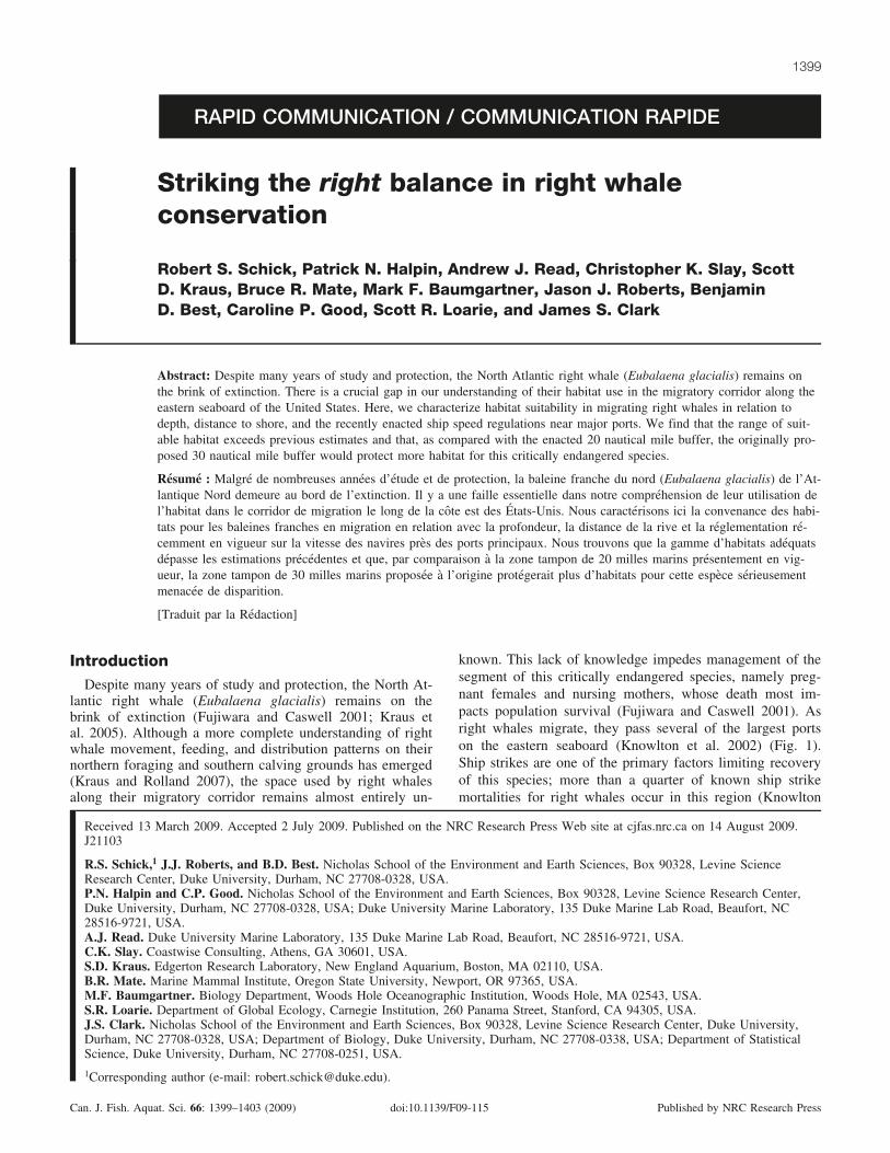
Fig. 1. The portions of two movement paths that cross the migratory corridor are depicted in relation to the proposed (red) and enacted(blue) seasonal management areas (SMA). Light grey and dark grey circles are estimated locations of NEA 1812 and NEA 2320. Majorports are in beige. The upper inset map shows the last four locations of NEA 2320’s track in grey with the buffered track shown in lightgrey. The lower inset map highlights the study area. TEU, twenty foot equivalent units; EEZ, exclusive economic zone.
1400 Can. J. Fish. Aquat. Sci. Vol. 66, 2009
Published by NRC Research Press
accompanied by a newborn calf at the time of tagging.NEA 2320 is a reproductively active female first identifiedin January 1993 off Florida and last seen in March 2008 inCape Cod Bay. Information about age, sighting history, andreproductive status comes from The North Atlantic RightWhale Catalog (http://rwcatalog.neaq.org/Default.aspx, lastaccessed 12 December 2008). The track of NEA 1812 origi-nated off Fernandina Beach, Florida, on 21 February 1996and ended in the Gulf of Maine on 2 June 1996 (Fig. 1).(Note that the ports are symbol coded according to TEU(twenty foot equivalent units), where 1 TEU approximatelyrepresents the capacity of a standard shipping container, or1360 ft3, information taken from the United States ArmyCorps of Engineers, Navigation Data Center (http://www.iwr.usace.army.mil/ndc/wcsc/by_portname06.htm, last ac-cessed 19 February 2009).) The track of NEA 2320 origi-nated in the Bay of Fundy on 11 August 2000 and endedjust north of the calving grounds in Florida and Georgia on15 December 2000 (Fig. 1). In both cases, we ignored theGulf of Maine portion of the tracks because this compriseda demonstrably different behavioral state and locations wereno longer in the migratory corridor. For NEA 1812, 24 loca-tions spanned the calving ground and migratory corridor; forNEA 2320, 16 locations spanned the migratory corridor.NEA 1812 transmitted for 103 days and covered 2676 km(average of 26.0 km�day–1). NEA 2320 transmitted for127 days and covered 5612 km (average of 44.2 km�day–1).
MethodsBecause the model from Schick et al. (2008) assumes
equal time intervals between locations, we fit the modelfrom Jonsen et al. (2005) to the data as a first-stage filter toobtain an estimate of the true path. The model from Jonsenet al. (2005) is a state-space model that uses a directed cor-related random walk as the process model and that returnsdaily estimates of the animal’s true position and, where ap-propriate, estimates of a behavioral state. We then bufferedpositions along this estimated path to compare actual loca-tion visited at time t versus a range of possible locations.We chose a 100 km spatial buffer around each location attime t because this distance slightly exceeded the maximumdaily distance covered by the individual whales (97 km).Using GIS, we sampled two environmental covariates, waterdepth (metres) and distance to shore (kilometres), at each ofthese possible locations along the path of the individual aswell as at the centroid of each 4 km grid cell within the buf-fered track (Fig. 1, inset). Because there is no literature de-scribing the response of migrating right whales to dynamiccovariates such as sea surface temperate, we did not includethem in our model. In certain cases where shorter move-ments by the animal resulted in overlap of the spatial buf-fers, a separate time index was derived for each of thepoints. In other words, at time t = 3, the possible locationswere, for example, 100. At t = 4, the locations were also100, but since the animal only moved 5 km, 90 of these100 possible locations were the same as the previous timestep. In this case, we calculated and kept the space and timeindex of each patch in relation to when it could have beenvisited by the moving animal (Fig. 1, inset). We built uponthese two covariates by separately calculating quadraticterms for both water depth and distance to shore. We used
quadratic terms to see if there was an optimal range foreach of these covariates and because without them, the as-sumption would be that right whales prefer the smallest pos-sible values for each covariate, i.e., the closer right whalesare to shore, the higher the suitability. In addition, we calcu-lated the distance from the animal’s position at time t – 1 tothe current location of possible patches at time t. This al-lowed us to make inference on how distance from the ani-mal affects suitability.
To these data, we applied the Bayesian movement modelfrom Schick et al. (2008) that embeds a resource selectionfunction (Manly and McDonald 2002) inside a movementmodel in an effort to infer the parameters governing relativehabitat suitability h, where h is a function of environmentalcovariates. That is, how does the suitability of the patchchosen differ from those the animal could have chosen tovisit? We modeled suitability as a function of the two envi-ronmental covariates, including both linear and quadraticterms for both. The model from Schick et al. (2008) exploitsobserved movement relative to the options available as thebasis for inference on habitat preference.
We used these covariates and regression parameters tomodel the suitability h of areas along the track. At eachpoint along the movement track, the animal chooses one lo-cation of many possible locations. We used a multinomialfor the likelihood based on the assumption that the animalchooses the location with probability q. Probability q wasmechanistically derived from the relative suitability h of thevisited patch. Suitability h was normalized by dividing bythe sum of h for all other patches. Suitability h had a func-tional form Xb. We constructed X, and in a Gibbs samplingframework, we drew bs from a truncated multivariate nor-mal distribution with mean values based on the current val-ues of b(g), where the g superscript represents the currentstep in the Gibbs loop. The density a of the proposed valueis determined in relation to the current value, and if a > 1,the proposed values were accepted. We derived and used anempirical covariance matrix V for this multivariate distribu-tion. A default covariance matrix was used at the start of theGibbs sampler, and we then twice calculated and employedthe empirical covariance matrix after 1000 and 100 000 stepsthrough the Gibbs sampler. We used uninformative flat pri-ors centered on 0 with large variance. We ran the Gibbssampler for 250 000 steps, saving the last thinned 150 000values. Summary statistics were calculated for each of theposterior estimates of the parameters. To display habitatsuitability, we used median estimates of the regression pa-rameters and plotted estimates of suitability around eachpoint. For the global suitability, we fixed distance and depthat their mean values while calculating suitability as a func-tion of distance to shore.
Results
Results from the two migratory tracks analyzed here(whales NEA 1812 and NEA 2320) indicate that the esti-mate of habitat suitability should be revised farther offshore(Fig. 2a). Peak suitability values for distance to shore areslightly farther offshore for NEA 1812 than for NEA 2320(Fig. 2a). In particular, NEA 1812, a migrating female witha newborn calf, occurred relatively far offshore during some
Schick et al. 1401
Published by NRC Research Press
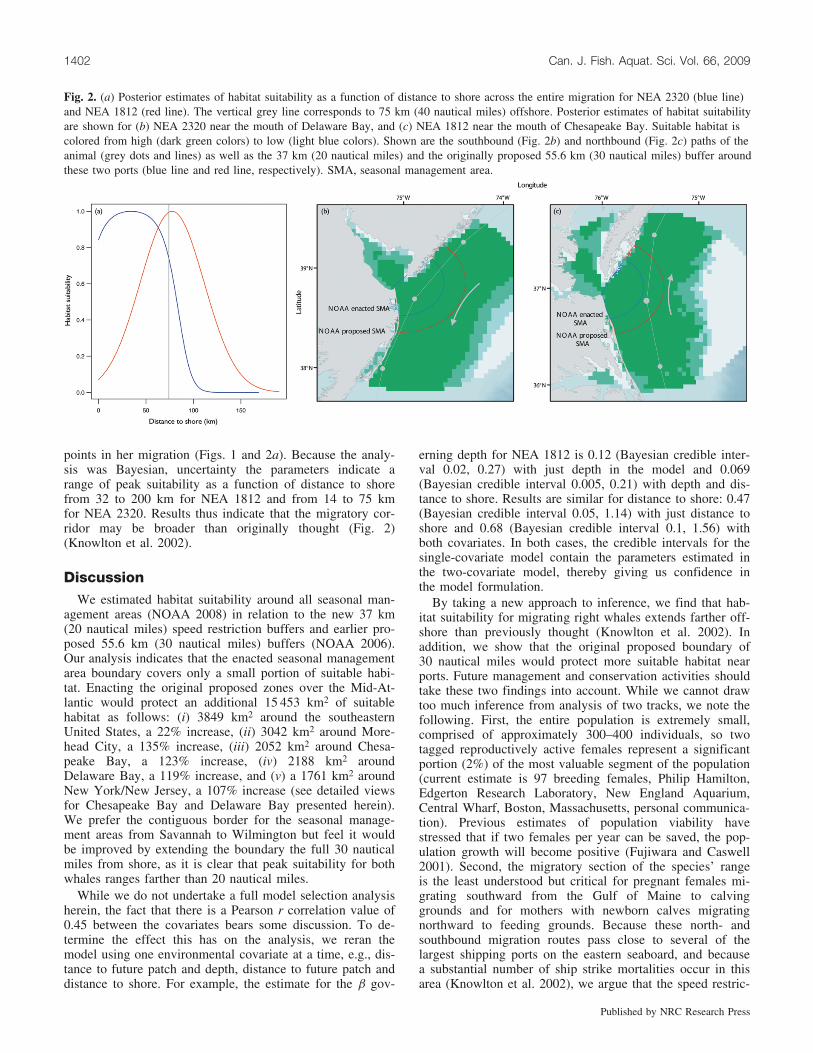
points in her migration (Figs. 1 and 2a). Because the analy-sis was Bayesian, uncertainty the parameters indicate arange of peak suitability as a function of distance to shorefrom 32 to 200 km for NEA 1812 and from 14 to 75 kmfor NEA 2320. Results thus indicate that the migratory cor-ridor may be broader than originally thought (Fig. 2)(Knowlton et al. 2002).
DiscussionWe estimated habitat suitability around all seasonal man-
agement areas (NOAA 2008) in relation to the new 37 km(20 nautical miles) speed restriction buffers and earlier pro-posed 55.6 km (30 nautical miles) buffers (NOAA 2006).Our analysis indicates that the enacted seasonal managementarea boundary covers only a small portion of suitable habi-tat. Enacting the original proposed zones over the Mid-At-lantic would protect an additional 15 453 km2 of suitablehabitat as follows: (i) 3849 km2 around the southeasternUnited States, a 22% increase, (ii) 3042 km2 around More-head City, a 135% increase, (iii) 2052 km2 around Chesa-peake Bay, a 123% increase, (iv) 2188 km2 aroundDelaware Bay, a 119% increase, and (v) a 1761 km2 aroundNew York/New Jersey, a 107% increase (see detailed viewsfor Chesapeake Bay and Delaware Bay presented herein).We prefer the contiguous border for the seasonal manage-ment areas from Savannah to Wilmington but feel it wouldbe improved by extending the boundary the full 30 nauticalmiles from shore, as it is clear that peak suitability for bothwhales ranges farther than 20 nautical miles.
While we do not undertake a full model selection analysisherein, the fact that there is a Pearson r correlation value of0.45 between the covariates bears some discussion. To de-termine the effect this has on the analysis, we reran themodel using one environmental covariate at a time, e.g., dis-tance to future patch and depth, distance to future patch anddistance to shore. For example, the estimate for the b gov-
erning depth for NEA 1812 is 0.12 (Bayesian credible inter-val 0.02, 0.27) with just depth in the model and 0.069(Bayesian credible interval 0.005, 0.21) with depth and dis-tance to shore. Results are similar for distance to shore: 0.47(Bayesian credible interval 0.05, 1.14) with just distance toshore and 0.68 (Bayesian credible interval 0.1, 1.56) withboth covariates. In both cases, the credible intervals for thesingle-covariate model contain the parameters estimated inthe two-covariate model, thereby giving us confidence inthe model formulation.
By taking a new approach to inference, we find that hab-itat suitability for migrating right whales extends farther off-shore than previously thought (Knowlton et al. 2002). Inaddition, we show that the original proposed boundary of30 nautical miles would protect more suitable habitat nearports. Future management and conservation activities shouldtake these two findings into account. While we cannot drawtoo much inference from analysis of two tracks, we note thefollowing. First, the entire population is extremely small,comprised of approximately 300–400 individuals, so twotagged reproductively active females represent a significantportion (2%) of the most valuable segment of the population(current estimate is 97 breeding females, Philip Hamilton,Edgerton Research Laboratory, New England Aquarium,Central Wharf, Boston, Massachusetts, personal communica-tion). Previous estimates of population viability havestressed that if two females per year can be saved, the pop-ulation growth will become positive (Fujiwara and Caswell2001). Second, the migratory section of the species’ rangeis the least understood but critical for pregnant females mi-grating southward from the Gulf of Maine to calvinggrounds and for mothers with newborn calves migratingnorthward to feeding grounds. Because these north- andsouthbound migration routes pass close to several of thelargest shipping ports on the eastern seaboard, and becausea substantial number of ship strike mortalities occur in thisarea (Knowlton et al. 2002), we argue that the speed restric-
Fig. 2. (a) Posterior estimates of habitat suitability as a function of distance to shore across the entire migration for NEA 2320 (blue line)and NEA 1812 (red line). The vertical grey line corresponds to 75 km (40 nautical miles) offshore. Posterior estimates of habitat suitabilityare shown for (b) NEA 2320 near the mouth of Delaware Bay, and (c) NEA 1812 near the mouth of Chesapeake Bay. Suitable habitat iscolored from high (dark green colors) to low (light blue colors). Shown are the southbound (Fig. 2b) and northbound (Fig. 2c) paths of theanimal (grey dots and lines) as well as the 37 km (20 nautical miles) and the originally proposed 55.6 km (30 nautical miles) buffer aroundthese two ports (blue line and red line, respectively). SMA, seasonal management area.
1402 Can. J. Fish. Aquat. Sci. Vol. 66, 2009
Published by NRC Research Press

tion boundaries be revisited. While we are not estimatingrisk of ship strike, previous work has documented the suc-cessful reduction in risk of ship strike to right whales witha combination of traffic separation schemes and speed re-strictions (Fonnesbeck et al. 2008; Vanderlaan et al. 2008).Incorporating the results presented here in conservation andmanagement schemes would protect a larger portion of rightwhale habitat in this critical yet understudied area of theirrange.
AcknowledgementsWe thank Martin Biuw and two anonymous reviewers
whose comments considerably strengthened this manuscript.This work was supported in part by SERDP/DoD grantW912HQ-04-C-0011 to A.J. Read and P.N. Halpin as wellas a James B. Duke Fellowship and a Harvey L. Smith Dis-sertation Year Fellowship to R.S. Schick.
ReferencesBaumgartner, M.F., and Mate, B.R. 2005. Summer and fall habitat
of North Atlantic right whales (Eubalaena glacialis) inferredfrom satellite telemetry. Can. J. Fish. Aquat. Sci. 62(3): 527–543. doi:10.1139/f04-238.
Fonnesbeck, C.J., Garrison, L.P., Ward-Geiger, L.I., and Baum-stark, R.D. 2008. Bayesian hierarchichal model for evaluatingthe risk of vessel strikes on North Atlantic right whales in theSE United States. Endanger. Species Res. 6: 87–94. doi:10.3354/esr00134.
Fujiwara, M., and Caswell, H. 2001. Demography of the endan-gered North Atlantic right whale. Nature, 414(6863): 537–541.doi:10.1038/35107054. PMID:11734852.
Jonsen, I., Flemming, J.M., and Myers, R. 2005. Robust state-spacemodeling of animal movement data. Ecology, 86(11): 2874–2880. doi:10.1890/04-1852.
Knowlton, A., Ring, J., and Russell, B. 2002. Right whale sightingsand survey effort in the mid-atlantic region: migratory corridor,time frame, and proximity to port entrances. A report submittedto the NMFS Ship Strike Working Group. Available from www.nero.noaa.gov/shipstrike/ssr/midatanticreportrFINAL.pdf
Kraus, S., and Rolland, R. 2007. The urban whale: North Atlanticright whales at the crossroads. Harvard University Press, Cam-bridge, Mass.
Kraus, S.D., Brown, M.W., Caswell, H., Clark, C.W., Fujiwara, M.,Hamilton, P.K., Kenney, R.D., Knowlton, A.R., Landry, S.,Mayo, C.A., McLellan, W.A., Moore, M.J., Nowacek, D.P.,Pabst, D.A., Read, A.J., and Rolland, R.M. 2005. North Atlanticright whales in crisis. Science, 309(5734): 561–562. doi:10.1126/science.1111200. PMID:16040692.
Manly, B., and McDonald, T. 2002. Resource selection by animals:statistical design and analysis for field studies. Kluwer Aca-demic Publishers, Boston, Mass.
NOAA. 2006. Endangered Fish and Wildlife; Proposed rule to im-plement speed restrictions to reduce the threat of ship collisions(26 June 2006). Federal Register Vol. 71. No. 122. pp. 36299–36313.
NOAA. 2008. Endangered Fish and Wildlife; Final rule to imple-ment speed restrictions to reduce the threat of ship collisionswith North Atlantic right whales (10 October 2008). FederalRegister Vol. 73. No. 198. pp. 60173–60191.
Schick, R.S., Loarie, S.R., Colchero, F., Best, B.D., Boustany, A.,Conde, D.A., Halpin, P.N., Joppa, L.N., McClellan, C.M., andClark, J.S. 2008. Understanding movement data and movementprocesses: current and emerging directions. Ecol. Lett. 11(12):1338–1350. doi:10.1111/j.1461-0248.2008.01249.x. PMID:19046362.
Vanderlaan, A., Taggart, C., Serdynska, A., Kenney, R., andBrown, M. 2008. Reducing the risk of lethal encounters: vesselsand right whales in the Bay of Fundy and on the Scotian Shelf.Endanger. Species Res. 4: 283–297. doi:10.3354/esr00083.
Schick et al. 1403
Published by NRC Research Press