streetmap premium for arcgis custom roads arcgis pro...
TRANSCRIPT

StreetMap™ Premium for ArcGIS®
Custom Roads—ArcGIS Pro 2.1
March 2018

Copyright © 2018 Esri
All rights reserved.
Printed in the United States of America.
The information contained in this document is the exclusive property of Esri. This work is protected
under United States copyright law and other international copyright treaties and conventions. No
part of this work may be reproduced or transmitted in any form or by any means, electronic or
mechanical, including photocopying and recording, or by any information storage or retrieval
system, except as expressly permitted in writing by Esri. All requests should be sent to Attention:
Contracts and Legal Services Manager, Esri, 380 New York Street, Redlands, CA 92373-8100 USA.
The information contained in this document is subject to change without notice.
Esri, the Esri globe logo, StreetMap, ArcGIS, esri.com, and @esri.com are trademarks, service
marks, or registered marks of Esri in the United States, the European Community, or certain other
jurisdictions. Other companies and products or services mentioned herein may be trademarks,
service marks, or registered marks of their respective mark owners.
i
Table of Contents
Introduction to StreetMap Premium for ArcGIS Custom Roads .......1
Layer descriptions ...........................................................................2
Custom_Streets .............................................................................. 2
Custom_Streets_Override ................................................................. 2
Custom_Turns ................................................................................ 2
Editing templates ............................................................................4
Custom Streets ............................................................................... 4
Custom Streets Override .................................................................. 5
Loading Pre-existing Street Segments ............................................6
Tasks ...............................................................................................7
Merge existing street data into StreetMap Premium network dataset...... 7
Update process ............................................................................. 10
Reference documents .................................................................... 11
Support ......................................................................................... 12
Data dictionary .............................................................................. 13
Point layers .................................................................................. 13
Custom Streets Override Points (Custom_Streets_Override) ............ 13
Line layers .................................................................................... 13
Custom Streets for network (Custom_Streets) ............................... 13
Custom Turn Restrictions (Custom_Turns) ..................................... 24
Reference ..................................................................................... 36
Carto Values .............................................................................. 36
Directional Identifiers .................................................................. 37
Direction on Sign ........................................................................ 37
Hierarchy ................................................................................... 38
Maneuver Class .......................................................................... 38
Road Class ................................................................................. 38
1
Introduction to StreetMap Premium for ArcGIS Custom Roads
StreetMap™ Premium for ArcGIS® Custom Roads allows organizations to combine roads that they
manage with StreetMap Premium streets for a single continuous routable transportation network.
StreetMap Premium for ArcGIS provides ready-to-use geocoding, routing, and map display content
for use within ArcGIS Desktop and ArcGIS Enterprise, behind your firewall on infrastructure that
you manage. The Custom Roads edition of StreetMap Premium enables a specific capability for
routing—seamlessly routing on both custom roads and commercial streets. Once integrated, this
data can be used across the ArcGIS platform within ArcGIS Desktop, ArcGIS Enterprise, and even
packaged for use in Navigator for ArcGIS, provided that it is licensed accordingly.
Within the StreetMap Premium Custom Roads file geodatabase, there are three empty feature
classes that a geographic information system (GIS) analyst can either digitize or load roads into.
Once the custom roads are added and the network dataset is rebuilt, the combined network is
ready for routing.
StreetMap Premium Custom Roads is designed to be edited within ArcGIS Pro. When digitizing new
features, street network connectivity and attribute requirements are automatically enforced
through the use of editing templates that are part of the ArcGIS Pro document.
StreetMap Premium Custom Roads supports editing of three Custom_Streets feature classes. It is
not designed for editing of any other feature classes; for example, edits should not be made to the
Routing_Streets layer. This document describes the structure of the three Custom_Streets feature
classes and requirements for creating content within them.
The following licensing requirements are needed to use StreetMap Premium Custom Roads in
ArcGIS software:
• ArcGIS Desktop: To use within ArcGIS Pro, a StreetMap Premium license for ArcGIS
Desktop is required.
• ArcGIS Enterprise: To use within ArcGIS Enterprise, a StreetMap Premium license for
ArcGIS Server is required.
• Navigator for ArcGIS: To create a custom map for use in Navigator, the author must be
within ArcGIS Pro and have a StreetMap Premium Custom Roads license for ArcGIS Desktop
or ArcGIS Server. To consume and use custom Navigator maps that ArcGIS Pro has
packaged, each Navigator field worker must have a Navigator for ArcGIS license.
2
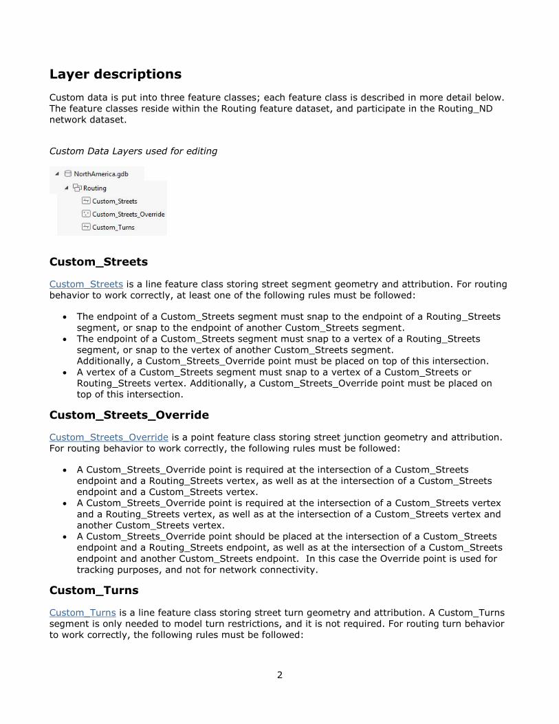
Layer descriptions
Custom data is put into three feature classes; each feature class is described in more detail below.
The feature classes reside within the Routing feature dataset, and participate in the Routing_ND
network dataset.
Custom Data Layers used for editing
Custom_Streets
Custom_Streets is a line feature class storing street segment geometry and attribution. For routing
behavior to work correctly, at least one of the following rules must be followed:
• The endpoint of a Custom_Streets segment must snap to the endpoint of a Routing_Streets
segment, or snap to the endpoint of another Custom_Streets segment.
• The endpoint of a Custom_Streets segment must snap to a vertex of a Routing_Streets
segment, or snap to the vertex of another Custom_Streets segment.
Additionally, a Custom_Streets_Override point must be placed on top of this intersection.
• A vertex of a Custom_Streets segment must snap to a vertex of a Custom_Streets or
Routing_Streets vertex. Additionally, a Custom_Streets_Override point must be placed on
top of this intersection.
Custom_Streets_Override
Custom_Streets_Override is a point feature class storing street junction geometry and attribution.
For routing behavior to work correctly, the following rules must be followed:
• A Custom_Streets_Override point is required at the intersection of a Custom_Streets
endpoint and a Routing_Streets vertex, as well as at the intersection of a Custom_Streets
endpoint and a Custom_Streets vertex.
• A Custom_Streets_Override point is required at the intersection of a Custom_Streets vertex
and a Routing_Streets vertex, as well as at the intersection of a Custom_Streets vertex and
another Custom_Streets vertex.
• A Custom_Streets_Override point should be placed at the intersection of a Custom_Streets
endpoint and a Routing_Streets endpoint, as well as at the intersection of a Custom_Streets
endpoint and another Custom_Streets endpoint. In this case the Override point is used for
tracking purposes, and not for network connectivity.
Custom_Turns
Custom_Turns is a line feature class storing street turn geometry and attribution. A Custom_Turns
segment is only needed to model turn restrictions, and it is not required. For routing turn behavior
to work correctly, the following rules must be followed:
3
• A Custom_Turns segment must snap to each street edge that is part of the turn.
• The directionality of the line segment must be considered, going from the first street edge to
the second street edge modeling the turn. Multiedge turns are also supported, so there can
be more than two street edges considered.
• The ObjectID attributes of the first street edge must be populated within the Edge1FID field,
and the ObjectID of the second street edge must be populated within the Edge2FID field.
Note: If the ObjectID of a street edge changes, the associated value in the turn feature also
needs to be updated.
• To restrict a turn, you must populate the RST_... fields in the Custom_Turns feature class
with a "Yes" value for each type of vehicle that is restricted from making that turn or a "No"
value for each type of vehicle for which the turn does not apply.

4
Editing templates
The StreetMap Premium Custom Roads project (used within ArcGIS Pro) includes editing templates
to help manage the properties of Custom_Streets when they are digitized or edited. Editing
templates are a standard feature of ArcGIS Pro and can greatly help manage the ease of creating
new features. Your organization may also choose to create new templates specific to your editing
needs. The following templates are part of the ArcGIS Pro project.
Editing Templates within the Custom Roads ArcGIS Pro Project
Custom Streets
• Connect Custom Street to Custom Street: Used to connect a Custom Street to a Custom
Street. When connecting a new Custom Street endpoint to a pre-existing Custom Street, the
pre-existing segment will be split.
• Connect Custom Street to Routing Street: Used to connect a Custom Street to a Routing
Street. When connecting a Custom Street endpoint to a Routing Street, the Routing Street
will have a vertex created. A Custom Streets Override point will automatically be created at
this intersection.
The following applies to both editing templates above:
• The FT_KPH and TF_KPH fields define the speed limit and have default values of 40 km/hour
(25 mph).
• The STREET_NAME field should be populated.
• The PAVED field (Yes or No values) is used within travel modes. When set to Yes, the
streets are avoided when using the following travel modes: Driving Time, Driving Distance,
Trucking Time, and Trucking Distance. These streets are traversable when using the
following travel modes: Rural Driving Time, Rural Driving Distance, Walking Time, and
Walking Distance.
Note: Advanced Network Analyst behavior such as one-way streets and travel restrictions may be
enforced within your newly created Custom_Streets features. This utilizes standard Network
Analyst functionality, using the data model of StreetMap Premium Custom Roads. For example:
• A one-way street may be modeled by populating the FT_RST_... and TF_RST_... fields in the
Custom_Streets feature class for each type of vehicle with a "Yes" value if the vehicle is not
allowed to travel in the given direction, and a "No" value if the vehicle is allowed to travel in
5
that given direction. There are two fields, one for each direction of travel, and the fields are
relative to the digitized direction of the street.
• A travel restriction may be modeled by populating the restriction attribute(s) accordingly within
the field values.
Custom Streets Override
• Custom Streets Override: Used to identify where Custom_Streets connect with
Routing_Streets. These must be captured for the purposes of updating the content when a
new StreetMap Premium database is available.

6
Loading Pre-existing Street Segments
Although existing road features may be appended into the custom streets layers, the connectivity
and attribute requirements for routing are not automatically enforced when appending. Additional
editing to enforce network connectivity and to populate attribution is required if existing roads are
appended to the custom streets layers.
7
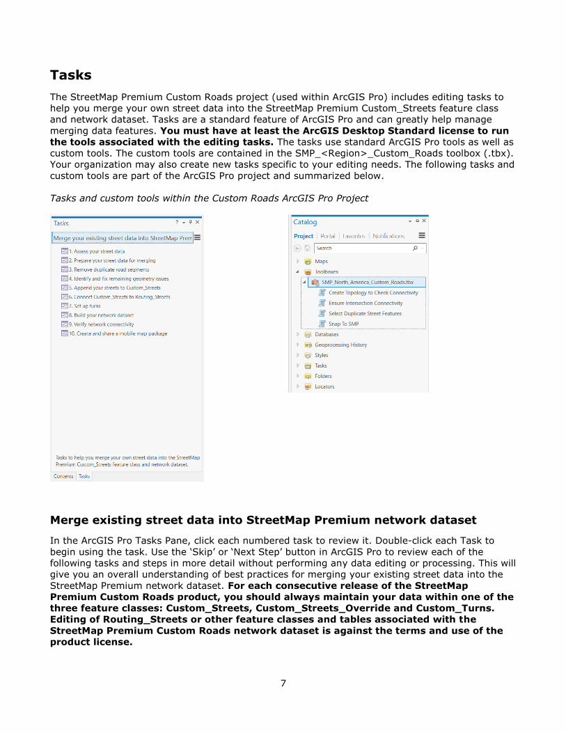
Tasks
The StreetMap Premium Custom Roads project (used within ArcGIS Pro) includes editing tasks to
help you merge your own street data into the StreetMap Premium Custom_Streets feature class
and network dataset. Tasks are a standard feature of ArcGIS Pro and can greatly help manage
merging data features. You must have at least the ArcGIS Desktop Standard license to run
the tools associated with the editing tasks. The tasks use standard ArcGIS Pro tools as well as
custom tools. The custom tools are contained in the SMP_<Region>_Custom_Roads toolbox (.tbx).
Your organization may also create new tasks specific to your editing needs. The following tasks and
custom tools are part of the ArcGIS Pro project and summarized below.
Tasks and custom tools within the Custom Roads ArcGIS Pro Project
Merge existing street data into StreetMap Premium network dataset
In the ArcGIS Pro Tasks Pane, click each numbered task to review it. Double-click each Task to
begin using the task. Use the ‘Skip’ or ‘Next Step’ button in ArcGIS Pro to review each of the
following tasks and steps in more detail without performing any data editing or processing. This will
give you an overall understanding of best practices for merging your existing street data into the
StreetMap Premium network dataset. For each consecutive release of the StreetMap
Premium Custom Roads product, you should always maintain your data within one of the
three feature classes: Custom_Streets, Custom_Streets_Override and Custom_Turns.
Editing of Routing_Streets or other feature classes and tables associated with the
StreetMap Premium Custom Roads network dataset is against the terms and use of the
product license.
8
Task 1: Assess your street data
In Task 1, steps are given to examine and prepare your own street data prior to merging with
StreetMap Premium data. This task walks you through some attribute and geometry checks to
ensure that your data is ready for merging.
Task 2: Prepare your street data for merging
This task helps you to identify and correct intersection connectivity. In order for your network
dataset to function properly, your street data must be well connected at intersections. This task
guides you through some steps to ensure good connectivity at intersections within your own street
data.
The StreetMap Premium network dataset uses End Point connectivity. Consequently, for the road
features in your network dataset to connect properly at intersections, your features must touch at
end points. Note that if your data contains bridges, tunnels, overpasses, or other locations where
streets cross over or under each other but do not physically connect, you will have to fix these
locations if these features should not intersect.
Task 3: Remove duplicate road segments
Task 3 helps you identify road segments in your street data that duplicate StreetMap Premium road
segments, and then review the selection and delete them. The Select Duplicate Street Features
tool is provided to help accomplish this task.
Task 4: Identify and fix remaining geometry issues
This task uses the Create Topology to Check Connectivity tool to create a topology with rules
to look for common causes of connectivity problems.
The tool creates a new feature dataset with a copy of your streets in the specified workspace. Then
it creates a topology and adds rules to it which help identify areas of problem geometry.
Task 5: Append your streets to Custom_Streets
This task helps you transfer your roads into the empty Custom_Streets feature class for use with
the StreetMap Premium dataset. It also helps you transfer any relevant attributes from your
original data.
Task 6: Connect Custom_Streets to Routing_Streets
To ensure good network connectivity, the features in Custom_Streets must intersect with the street
features in Routing_Streets. If you are merging existing data into StreetMap Premium, it is likely
your own roads will not be coincident with the existing StreetMap Premium data. Intersection
points will fall short of connecting or will have dangles. Additionally, points of connection must have
either feature end points or vertices with coincident override junctions. Use this task to correct
these problems and ensure good network dataset connectivity between Custom_Streets and

9
Routing_Streets. The Snap to SMP and Ensure Intersection Connectivity tools are provided to
help accomplish this task.
Task 7: Set up turns
Use this task to set up turns to control turn restrictions at intersections. There are many types of
turn features and restrictions that can be added to network datasets. The ArcGIS Network Analyst
data prep tutorial provides detailed instructions and graphics to guide you in digitizing turns.
These tutorials may be reviewed before getting started adding or editing turn restrictions.
Task 8: Build your network dataset
Use the Build Network tool to incorporate your network dataset edits into the StreetMap Premium
network dataset (Routing_ND). If you get build errors, review them along with the Common build
errors documentation page. Fix any errors, and run the Build Network tool again.
Task 9: Verify network connectivity
This task will help you assess whether your network dataset is adequately connected using network
functions like Service Area and Route analyses.
Task 10: Create and share a mobile map package
In this task, use the Create Mobile Map Package tool to package your custom network dataset
along with mapping layers and a locator for mobile use. Since the StreetMap Premium Custom
Roads extent is for the entire region, do not use the Default extent setting, use your Area of
Interest instead to create a small package size efficient for mobile use. When packaging the
network dataset, warnings about live traffic may be ignored because a live traffic service cannot be
used in a mobile map package. Similarly, other online mapping services cannot be packaged for
mobile use. Note that the Navigator app requires a map package to contain a locator to be
recognized as a valid map package. Only one composite locator or an individual locator is usable by
the package.
Then, use the Share Package tool to share your package with your ArcGIS organization so users
can download the package for use with the Navigator app.
10
Update process
Once data is captured into the custom data layers, your organization will want to use these
features with future StreetMap Premium updates. The following process should be followed for
migrating custom streets features into a new update of StreetMap Premium:
1. Append the Custom_Streets, Custom_Streets_Override, and Custom_Turns features from
your existing version of StreetMap Premium into the equivalent feature classes in the new
version of StreetMap Premium.
2. Review the segments and points that you just loaded into the new StreetMap Premium
database. Compare the Custom_Streets segments against the Routing_Streets segments to
identify situations where updates to the Routing_Streets layer will impact connectivity to
your Custom_Streets.
• Identify any situation where a Routing_Streets segment now represents a
Custom_Streets segment.
o In these situations, delete your Custom_Streets segment to avoid duplication of
streets.
o Edit any Custom_Streets segments that may have been connected to your newly
deleted feature, as appropriate.
• Identify any situation where a Routing_Streets segment has moved resulting in your
Custom_Streets segments no longer being connected to it.
o Edit and move the endpoint of your Custom_Streets to be coincident to the
Routing_Streets. If a Custom_Street_Override is present at this location, also
edit and move it.
Note: To identify these situations and locations, you may want to use a topology rule.
3. Review the Custom_Turns segments that you just loaded into the new StreetMap Premium
database. Identify any situations where updates to the Routing_Streets layer will impact the
connectivity and snapping of your Custom_Turns segments.
• For example, if a Routing_Streets segment has moved, move the Custom_Turns
segment to snap to the segment once again.
Note: To identify these situations and locations, you may want to use a topology rule.
4. Run Update by Geometry on the updated Custom_Turns feature class.
5. Select all Routing_Streets segments that intersect the Custom_Streets segments. Run
Integrate with a cluster tolerance of 0. This will insert a vertex where these two locations
intersect. Note that a Custom_Streets_Override point must exist at this intersection, or
network connectivity will not be enforced.
6. Run Build Network. This will connect the network dataset for routing using the newly
loaded Custom_Streets features.
7. Test the network to ensure connectivity by using test stop locations and the ArcGIS Network
Analyst extension.
Note: Where the addition of a Custom_Streets feature may have split a Routing_Streets
feature in the original data, this update process does not split the Routing_Streets, and
connectivity is enforced via vertex and Custom_Street_Override in the new data.

11
Reference documents
Learn more about StreetMap Premium for ArcGIS:
• esri.com/data/streetmap
• server.arcgis.com/en/streetmap-premium/latest/get-started/overview.htm
• pro.arcgis.com/en/pro-app/help/data/streetmap-premium/what-is-streetmap-premium-.htm
Learn more about network datasets and how to build one:
• desktop.arcgis.com/en/arcmap/latest/extensions/network-analyst/what-is-a-network-
dataset.htm
Learn more about the Network Analyst extension:
• pro.arcgis.com/en/pro-app/help/analysis/networks/what-is-network-analyst-.htm
• pro.arcgis.com/en/pro-app/tool-reference/network-analyst/an-overview-of-the-network-
analyst-toolbox.htm
Learn more about creating turns and setting directions (This is ArcMap documentation, but the
same concepts apply in ArcGIS Pro):
• desktop.arcgis.com/en/arcmap/latest/extensions/network-analyst/creating-a-turn-
feature.htm
• desktop.arcgis.com/en/arcmap/latest/extensions/network-analyst/setting-directions.htm
Learn more about preparing maps for use with Navigator for ArcGIS:
• doc.arcgis.com/en/navigator/prepare-maps/prepare-maps.htm

12
Support
For technical restrictions, system requirements, and other support information regarding StreetMap
Premium for ArcGIS Custom Roads, see StreetMap Premium for ArcGIS on the ArcGIS Server
website.
13
Data dictionary
Point layers
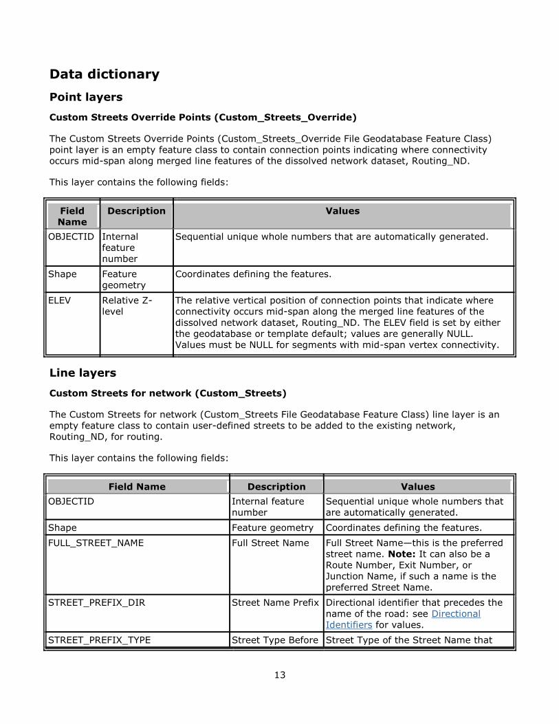
Custom Streets Override Points (Custom_Streets_Override)
The Custom Streets Override Points (Custom_Streets_Override File Geodatabase Feature Class)
point layer is an empty feature class to contain connection points indicating where connectivity
occurs mid-span along merged line features of the dissolved network dataset, Routing_ND.
This layer contains the following fields:
Field
Name
Description Values
OBJECTID Internal
feature
number
Sequential unique whole numbers that are automatically generated.
Shape Feature
geometry
Coordinates defining the features.
ELEV Relative Z-
level
The relative vertical position of connection points that indicate where
connectivity occurs mid-span along the merged line features of the
dissolved network dataset, Routing_ND. The ELEV field is set by either
the geodatabase or template default; values are generally NULL.
Values must be NULL for segments with mid-span vertex connectivity.
Line layers
Custom Streets for network (Custom_Streets)
The Custom Streets for network (Custom_Streets File Geodatabase Feature Class) line layer is an
empty feature class to contain user-defined streets to be added to the existing network,
Routing_ND, for routing.
This layer contains the following fields:
Field Name Description Values
OBJECTID Internal feature
number
Sequential unique whole numbers that
are automatically generated.
Shape Feature geometry Coordinates defining the features.
FULL_STREET_NAME Full Street Name Full Street Name—this is the preferred
street name. Note: It can also be a
Route Number, Exit Number, or
Junction Name, if such a name is the
preferred Street Name.
STREET_PREFIX_DIR Street Name Prefix Directional identifier that precedes the
name of the road: see Directional
Identifiers for values.
STREET_PREFIX_TYPE Street Type Before Street Type of the Street Name that
14
Field Name Description Values
appears before the Base Name. Street
Types such as "Calle" or "Rue".
STREET_NAME Street Name Base Base Name of the Street Name.
STREET_TYPE Street Type After Street Type of the Street Name that
appears after the Base Name. Street
Types such as "Ave", "Avenue", "Fry",
"Hwy", "Rd", "St", "Trl", or "Walk".
STREET_DIR Street Name Suffix Directional identifier that follows the
name of the road: see Directional
Identifiers for values.
METERS Length of the link Lengths (meters) for the features.
When features are created, the
METERS field contains a NULL value.
When this value is NULL, then the
network dataset will utilize geodesic
distances derived from the feature's
geometry; if the user populates a value
in this field for a feature, then that
value is used for distance calculation
(the feature's geometry is not used for
distance calculation).
CONTROLLED_ACCESS Controlled Access Identifies roads with limited entrances
and exits that allow uninterrupted high
speed traffic flow: Y (Controlled Access)
or N (Not Controlled Access).
FERRY Ferry Type Indicates if the link is a ferry and if so,
the type of ferry: B (Boat), H (Not a
Ferry), or R (Rail).
PAVED Paved Indicates the road is paved (made of
materials that create a solid surface,
such as concrete, asphalt, brick or
cobblestone): Y (Paved) or N (Not
paved).
PUBLIC_ROAD Public Access Indicates if the link allows public
access: Y (Public access allowed) or N
(Public access not allowed).
TimeZoneID Time Zone
Identifier
Time Zone Identifier.
CARPOOL_ROAD Carpool Road Identifies a link where, at specific
times, all lanes serve as carpool lanes:
Y (Carpool Road), N (Not a Carpool
Road), or No value (Information is
Unknown).
EXPRESS_LANE Express Lane Identifies a link that serves as an
express lane: Y (Express Lane), N (Not
an Express Lane), or No value
15
Field Name Description Values
(Information is Unknown).
STREET_NAME_DIRECTION Street Highway
Direction
Official directional identifier assigned to
the highway that is the official direction
and not necessarily the travel direction:
see Direction on Sign for values.
FULL_STREET_NAME_ALT1 1st Alternate Full
Street Name
Alternate Full Street Name or Route
Number including the Street Name
Prefix, Street Name Suffix, Street
Types, and Direction on Sign (for Route
Numbers when available).
STREET_PREFIX_DIR_ALT1 1st Alternate
Street Name Prefix
Directional identifier that precedes the
name of the road: see Directional
Identifiers for values.
STREET_PREFIX_TYPE_ALT1 1st Alternate
Street Type Before
Street Type of the Street Name that
appears before the Base Name. Street
Types such as "Calle" or "Rue".
STREET_NAME_ALT1 1st Alternate Base
Name
Base Name of the Street Name.
STREET_TYPE_ALT1 1st Alternate
Street Type After
Street Type of the Street Name that
appears after the Base Name. Street
Types such as "Ave", "Avenue", "Fry",
"Hwy", "Rd", "St", "Trl", or "Walk".
STREET_DIR_ALT1 1st Alternate
Street Name Suffix
Directional identifier that follows the
name of the road: see Directional
Identifiers for values.
STREET_NAME_DIRECTION_ALT1 1st Alternate
Street Highway
Direction
Official directional identifier assigned to
the highway that is the official direction
and not necessarily the travel direction:
see Direction on Sign for values.
FULL_STREET_NAME_ALT2 2nd Alternate Full
Street Name
Alternate Full Street Name or Route
Number including the Street Name
Prefix, Street Name Suffix, Street
Types, and Direction on Sign (for Route
Numbers when available).
STREET_PREFIX_DIR_ALT2 2nd Alternate
Street Name Prefix
Directional identifier that precedes the
name of the road: see Directional
Identifiers for values.
STREET_PREFIX_TYPE_ALT2 2nd Alternate
Street Type Before
Street Type of the Street Name that
appears before the Base Name. Street
Types such as "Calle" or "Rue".
STREET_NAME_ALT2 2nd Alternate Base
Name
Base Name of the Street Name.
STREET_TYPE_ALT2 2nd Alternate
Street Type After
Street Type of the Street Name that
appears after the Base Name. Street
Types such as "Ave", "Avenue", "Fry",
"Hwy", "Rd", "St", "Trl", or "Walk".
16
Field Name Description Values
STREET_DIR_ALT2 2nd Alternate
Street Name Suffix
Directional identifier that follows the
name of the road: see Directional
Identifiers for values.
STREET_NAME_DIRECTION_ALT2 2nd Alternate
Street Highway
Direction
Official directional identifier assigned to
the highway that is the official direction
and not necessarily the travel direction:
see Direction on Sign for values.
FULL_STREET_NAME_ALT3 3rd Alternate Full
Street Name
Alternate Full Street Name or Route
Number including the Street Name
Prefix, Street Name Suffix, Street
Types, and Direction on Sign (for Route
Numbers when available).
STREET_PREFIX_DIR_ALT3 3rd Alternate
Street Name Prefix
Directional identifier that precedes the
name of the road: see Directional
Identifiers for values.
STREET_PREFIX_TYPE_ALT3 3rd Alternate
Street Type Before
Street Type of the Street Name that
appears before the Base Name. Street
Types such as "Calle" or "Rue".
STREET_NAME_ALT3 3rd Alternate Base
Name
Base Name of the Street Name.
STREET_TYPE_ALT3 3rd Alternate
Street Type After
Street Type of the Street Name that
appears after the Base Name. Street
Types such as "Ave", "Avenue", "Fry",
"Hwy", "Rd", "St", "Trl", or "Walk".
STREET_DIR_ALT3 3rd Alternate
Street Name Suffix
Directional identifier that follows the
name of the road: see Directional
Identifiers for values.
STREET_NAME_DIRECTION_ALT3 3rd Alternate
Street Highway
Direction
Official directional identifier assigned to
the highway that is the official direction
and not necessarily the travel direction:
see Direction on Sign for values.
FULL_STREET_NAME_ALT4 4th Alternate Full
Street Name
Alternate Full Street Name or Route
Number including the Street Name
Prefix, Street Name Suffix, Street
Types, and Direction on Sign (for Route
Numbers when available).
STREET_PREFIX_DIR_ALT4 4th Alternate
Street Name Prefix
Directional identifier that precedes the
name of the road: see Directional
Identifiers for values.
STREET_PREFIX_TYPE_ALT4 4th Alternate
Street Type Before
Street Type of the Street Name that
appears before the Base Name. Street
Types such as "Calle" or "Rue".
STREET_NAME_ALT4 4th Alternate Base
Name
Base Name of the Street Name.
STREET_TYPE_ALT4 4th Alternate
Street Type After
Street Type of the Street Name that
appears after the Base Name. Street
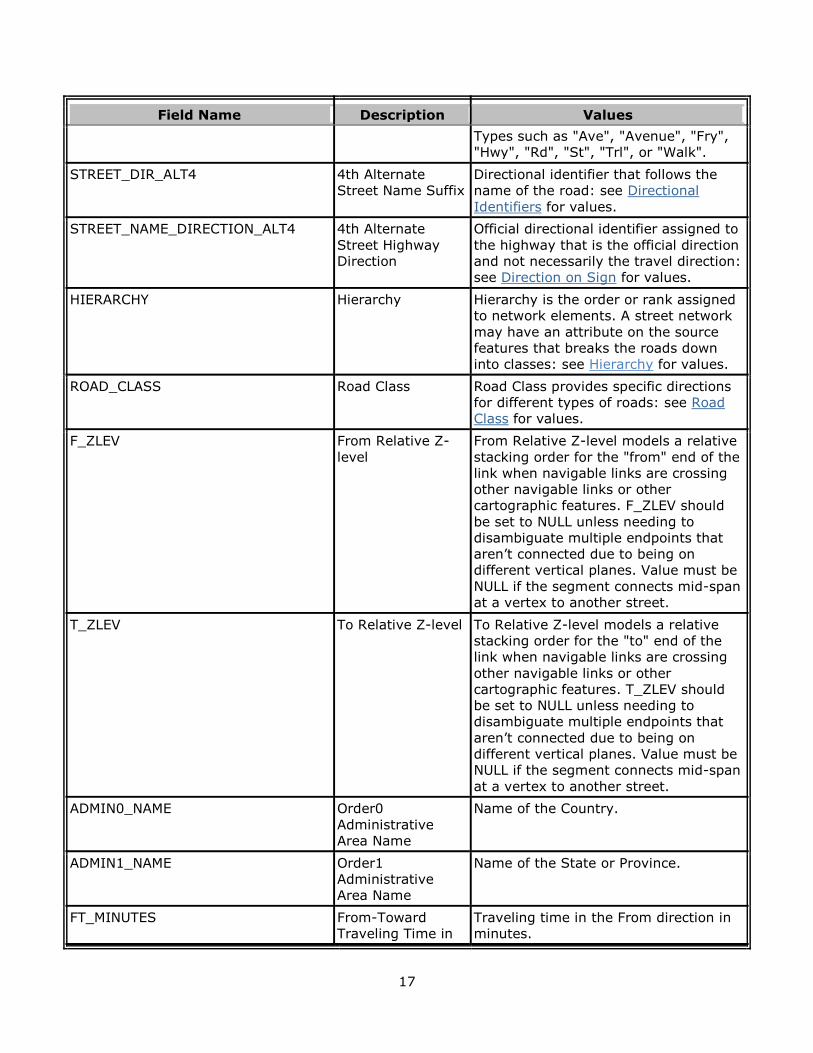
17
Field Name Description Values
Types such as "Ave", "Avenue", "Fry",
"Hwy", "Rd", "St", "Trl", or "Walk".
STREET_DIR_ALT4 4th Alternate
Street Name Suffix
Directional identifier that follows the
name of the road: see Directional
Identifiers for values.
STREET_NAME_DIRECTION_ALT4 4th Alternate
Street Highway
Direction
Official directional identifier assigned to
the highway that is the official direction
and not necessarily the travel direction:
see Direction on Sign for values.
HIERARCHY Hierarchy Hierarchy is the order or rank assigned
to network elements. A street network
may have an attribute on the source
features that breaks the roads down
into classes: see Hierarchy for values.
ROAD_CLASS Road Class Road Class provides specific directions
for different types of roads: see Road
Class for values.
F_ZLEV From Relative Z-
level
From Relative Z-level models a relative
stacking order for the "from" end of the
link when navigable links are crossing
other navigable links or other
cartographic features. F_ZLEV should
be set to NULL unless needing to
disambiguate multiple endpoints that
aren’t connected due to being on
different vertical planes. Value must be
NULL if the segment connects mid-span
at a vertex to another street.
T_ZLEV To Relative Z-level To Relative Z-level models a relative
stacking order for the "to" end of the
link when navigable links are crossing
other navigable links or other
cartographic features. T_ZLEV should
be set to NULL unless needing to
disambiguate multiple endpoints that
aren’t connected due to being on
different vertical planes. Value must be
NULL if the segment connects mid-span
at a vertex to another street.
ADMIN0_NAME Order0
Administrative
Area Name
Name of the Country.
ADMIN1_NAME Order1
Administrative
Area Name
Name of the State or Province.
FT_MINUTES From-Toward
Traveling Time in
Traveling time in the From direction in
minutes.
18
Field Name Description Values
Minutes
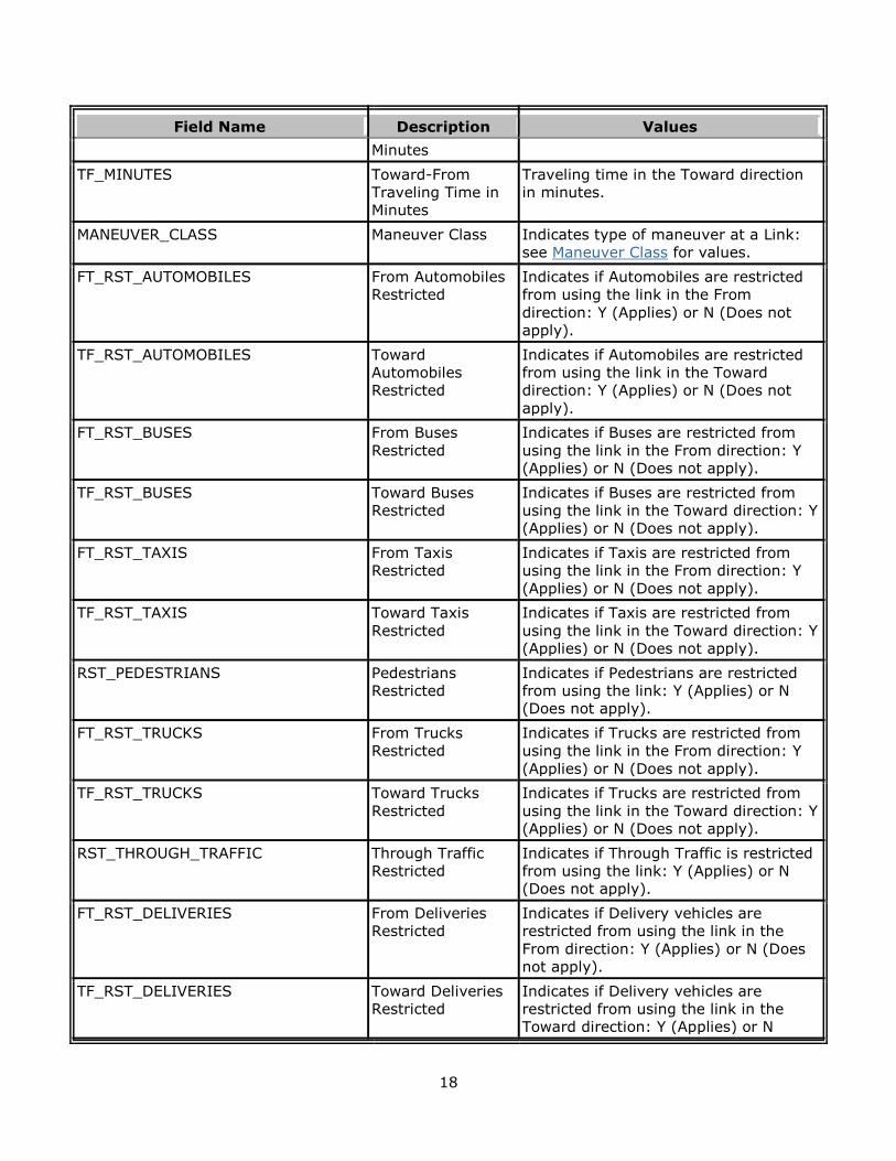
TF_MINUTES Toward-From
Traveling Time in
Minutes
Traveling time in the Toward direction
in minutes.
MANEUVER_CLASS Maneuver Class Indicates type of maneuver at a Link:
see Maneuver Class for values.
FT_RST_AUTOMOBILES From Automobiles
Restricted
Indicates if Automobiles are restricted
from using the link in the From
direction: Y (Applies) or N (Does not
apply).
TF_RST_AUTOMOBILES Toward
Automobiles
Restricted
Indicates if Automobiles are restricted
from using the link in the Toward
direction: Y (Applies) or N (Does not
apply).
FT_RST_BUSES From Buses
Restricted
Indicates if Buses are restricted from
using the link in the From direction: Y
(Applies) or N (Does not apply).
TF_RST_BUSES Toward Buses
Restricted
Indicates if Buses are restricted from
using the link in the Toward direction: Y
(Applies) or N (Does not apply).
FT_RST_TAXIS From Taxis
Restricted
Indicates if Taxis are restricted from
using the link in the From direction: Y
(Applies) or N (Does not apply).
TF_RST_TAXIS Toward Taxis
Restricted
Indicates if Taxis are restricted from
using the link in the Toward direction: Y
(Applies) or N (Does not apply).
RST_PEDESTRIANS Pedestrians
Restricted
Indicates if Pedestrians are restricted
from using the link: Y (Applies) or N
(Does not apply).
FT_RST_TRUCKS From Trucks
Restricted
Indicates if Trucks are restricted from
using the link in the From direction: Y
(Applies) or N (Does not apply).
TF_RST_TRUCKS Toward Trucks
Restricted
Indicates if Trucks are restricted from
using the link in the Toward direction: Y
(Applies) or N (Does not apply).
RST_THROUGH_TRAFFIC Through Traffic
Restricted
Indicates if Through Traffic is restricted
from using the link: Y (Applies) or N
(Does not apply).
FT_RST_DELIVERIES From Deliveries
Restricted
Indicates if Delivery vehicles are
restricted from using the link in the
From direction: Y (Applies) or N (Does
not apply).
TF_RST_DELIVERIES Toward Deliveries
Restricted
Indicates if Delivery vehicles are
restricted from using the link in the
Toward direction: Y (Applies) or N
19
Field Name Description Values
(Does not apply).
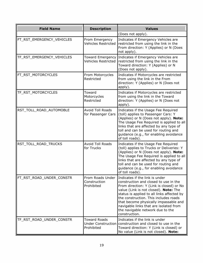
FT_RST_EMERGENCY_VEHICLES From Emergency
Vehicles Restricted
Indicates if Emergency Vehicles are
restricted from using the link in the
From direction: Y (Applies) or N (Does
not apply).
TF_RST_EMERGENCY_VEHICLES Toward Emergency
Vehicles Restricted
Indicates if Emergency Vehicles are
restricted from using the link in the
Toward direction: Y (Applies) or N
(Does not apply).
FT_RST_MOTORCYCLES From Motorcycles
Restricted
Indicates if Motorcycles are restricted
from using the link in the From
direction: Y (Applies) or N (Does not
apply).
TF_RST_MOTORCYCLES Toward
Motorcycles
Restricted
Indicates if Motorcycles are restricted
from using the link in the Toward
direction: Y (Applies) or N (Does not
apply).
RST_TOLL_ROAD_AUTOMOBLE Avoid Toll Roads
for Passenger Cars
Indicates if the Usage Fee Required
(toll) applies to Passenger Cars: Y
(Applies) or N (Does not apply). Note:
The Usage Fee Required is applied to all
links that are affected by any type of
toll and can be used for routing and
guidance (e.g., for enabling avoidance
of toll roads).
RST_TOLL_ROAD_TRUCKS Avoid Toll Roads
for Trucks
Indicates if the Usage Fee Required
(toll) applies to Trucks or Deliveries: Y
(Applies) or N (Does not apply). Note:
The Usage Fee Required is applied to all
links that are affected by any type of
toll and can be used for routing and
guidance (e.g., for enabling avoidance
of toll roads).
FT_RST_ROAD_UNDER_CONSTR From Roads Under
Construction
Prohibited
Indicates if the link is under
construction and closed to use in the
From direction: Y (Link is closed) or No
value (Link is not closed). Note: The
status is applied to all links affected by
the construction. This includes roads
that become physically impassable and
navigable links that are isolated from
the navigable network due to the
construction.
TF_RST_ROAD_UNDER_CONSTR Toward Roads
Under Construction
Prohibited
Indicates if the link is under
construction and closed to use in the
Toward direction: Y (Link is closed) or
No value (Link is not closed). Note:
20
Field Name Description Values
The status is applied to all links
affected by the construction. This
includes roads that become physically
impassable and navigable links that are
isolated from the navigable network
due to the construction.
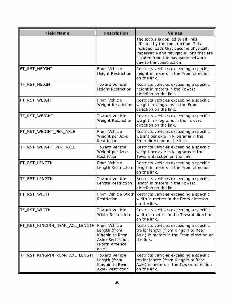
FT_RST_HEIGHT From Vehicle
Height Restriction
Restricts vehicles exceeding a specific
height in meters in the From direction
on the link.
TF_RST_HEIGHT Toward Vehicle
Height Restriction
Restricts vehicles exceeding a specific
height in meters in the Toward
direction on the link.
FT_RST_WEIGHT From Vehicle
Weight Restriction
Restricts vehicles exceeding a specific
weight in kilograms in the From
direction on the link.
TF_RST_WEIGHT Toward Vehicle
Weight Restriction
Restricts vehicles exceeding a specific
weight in kilograms in the Toward
direction on the link.
FT_RST_WEIGHT_PER_AXLE From Vehicle
Weight per Axle
Restriction
Restricts vehicles exceeding a specific
weight per axle in kilograms in the
From direction on the link.
TF_RST_WEIGHT_PER_AXLE Toward Vehicle
Weight per Axle
Restriction
Restricts vehicles exceeding a specific
weight per axle in kilograms in the
Toward direction on the link.
FT_RST_LENGTH From Vehicle
Length Restriction
Restricts vehicles exceeding a specific
length in meters in the From direction
on the link.
TF_RST_LENGTH Toward Vehicle
Length Restriction
Restricts vehicles exceeding a specific
length in meters in the Toward
direction on the link.
FT_RST_WIDTH From Vehicle Width
Restriction
Restricts vehicles exceeding a specific
width in meters in the From direction
on the link.
TF_RST_WIDTH Toward Vehicle
Width Restriction
Restricts vehicles exceeding a specific
width in meters in the Toward direction
on the link.
FT_RST_KINGPIN_REAR_AXL_LENGTH From Vehicle
Length (from
Kingpin to Rear
Axle) Restriction
(North America
only)
Restricts vehicles exceeding a specific
trailer length (from Kingpin to Rear
Axle) in meters in the From direction on
the link.
TF_RST_KINGPIN_REAR_AXL_LENGTH Toward Vehicle
Length (from
Kingpin to Rear
Axle) Restriction
Restricts vehicles exceeding a specific
trailer length (from Kingpin to Rear
Axle) in meters in the Toward direction
on the link.
21
Field Name Description Values
(North America
only)
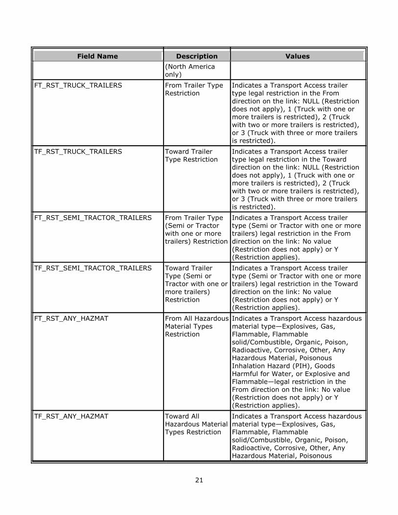
FT_RST_TRUCK_TRAILERS From Trailer Type
Restriction
Indicates a Transport Access trailer
type legal restriction in the From
direction on the link: NULL (Restriction
does not apply), 1 (Truck with one or
more trailers is restricted), 2 (Truck
with two or more trailers is restricted),
or 3 (Truck with three or more trailers
is restricted).
TF_RST_TRUCK_TRAILERS Toward Trailer
Type Restriction
Indicates a Transport Access trailer
type legal restriction in the Toward
direction on the link: NULL (Restriction
does not apply), 1 (Truck with one or
more trailers is restricted), 2 (Truck
with two or more trailers is restricted),
or 3 (Truck with three or more trailers
is restricted).
FT_RST_SEMI_TRACTOR_TRAILERS From Trailer Type
(Semi or Tractor
with one or more
trailers) Restriction
Indicates a Transport Access trailer
type (Semi or Tractor with one or more
trailers) legal restriction in the From
direction on the link: No value
(Restriction does not apply) or Y
(Restriction applies).
TF_RST_SEMI_TRACTOR_TRAILERS Toward Trailer
Type (Semi or
Tractor with one or
more trailers)
Restriction
Indicates a Transport Access trailer
type (Semi or Tractor with one or more
trailers) legal restriction in the Toward
direction on the link: No value
(Restriction does not apply) or Y
(Restriction applies).
FT_RST_ANY_HAZMAT From All Hazardous
Material Types
Restriction
Indicates a Transport Access hazardous
material type—Explosives, Gas,
Flammable, Flammable
solid/Combustible, Organic, Poison,
Radioactive, Corrosive, Other, Any
Hazardous Material, Poisonous
Inhalation Hazard (PIH), Goods
Harmful for Water, or Explosive and
Flammable—legal restriction in the
From direction on the link: No value
(Restriction does not apply) or Y
(Restriction applies).
TF_RST_ANY_HAZMAT Toward All
Hazardous Material
Types Restriction
Indicates a Transport Access hazardous
material type—Explosives, Gas,
Flammable, Flammable
solid/Combustible, Organic, Poison,
Radioactive, Corrosive, Other, Any
Hazardous Material, Poisonous
22
Field Name Description Values
Inhalation Hazard (PIH), Goods
Harmful for Water, or Explosive and
Flammable—legal restriction in the
Toward direction on the link: No value
(Restriction does not apply) or Y
(Restriction applies).
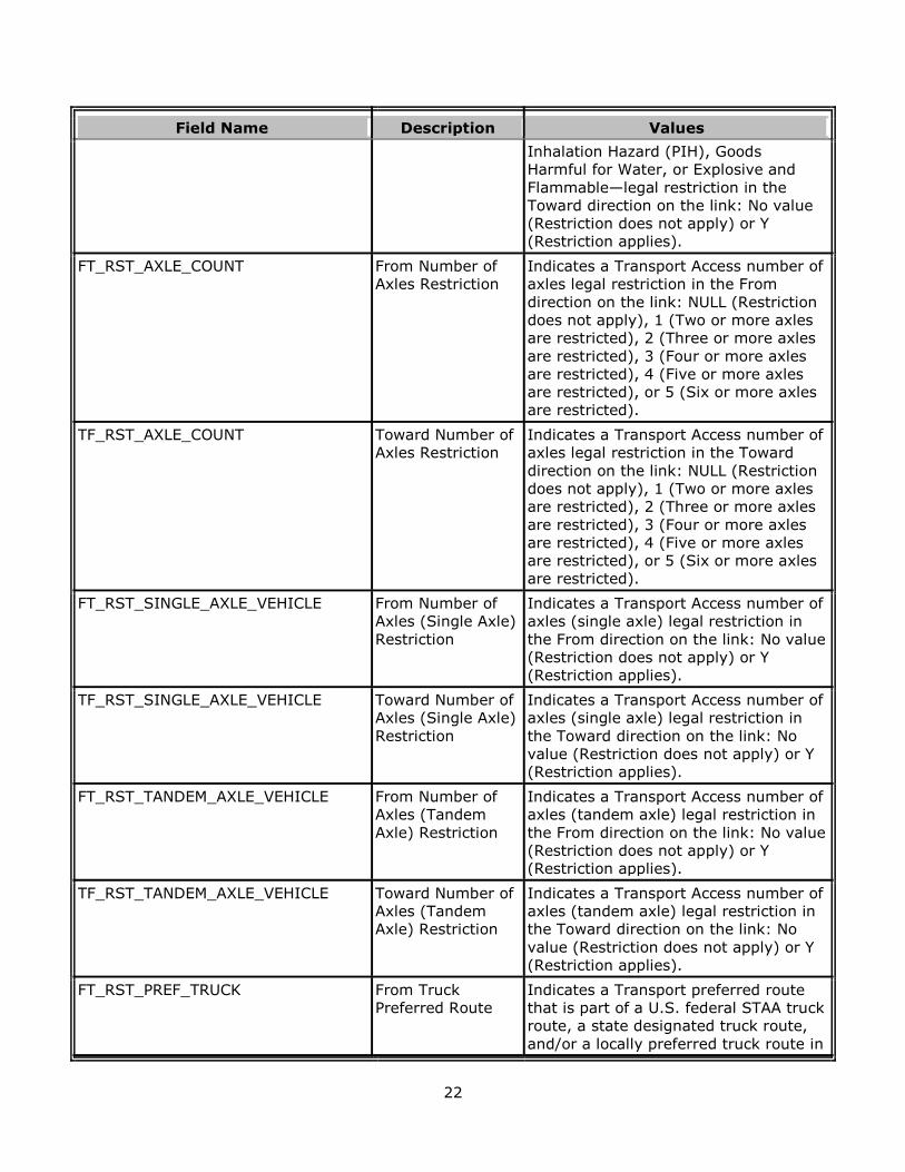
FT_RST_AXLE_COUNT From Number of
Axles Restriction
Indicates a Transport Access number of
axles legal restriction in the From
direction on the link: NULL (Restriction
does not apply), 1 (Two or more axles
are restricted), 2 (Three or more axles
are restricted), 3 (Four or more axles
are restricted), 4 (Five or more axles
are restricted), or 5 (Six or more axles
are restricted).
TF_RST_AXLE_COUNT Toward Number of
Axles Restriction
Indicates a Transport Access number of
axles legal restriction in the Toward
direction on the link: NULL (Restriction
does not apply), 1 (Two or more axles
are restricted), 2 (Three or more axles
are restricted), 3 (Four or more axles
are restricted), 4 (Five or more axles
are restricted), or 5 (Six or more axles
are restricted).
FT_RST_SINGLE_AXLE_VEHICLE From Number of
Axles (Single Axle)
Restriction
Indicates a Transport Access number of
axles (single axle) legal restriction in
the From direction on the link: No value
(Restriction does not apply) or Y
(Restriction applies).
TF_RST_SINGLE_AXLE_VEHICLE Toward Number of
Axles (Single Axle)
Restriction
Indicates a Transport Access number of
axles (single axle) legal restriction in
the Toward direction on the link: No
value (Restriction does not apply) or Y
(Restriction applies).
FT_RST_TANDEM_AXLE_VEHICLE From Number of
Axles (Tandem
Axle) Restriction
Indicates a Transport Access number of
axles (tandem axle) legal restriction in
the From direction on the link: No value
(Restriction does not apply) or Y
(Restriction applies).
TF_RST_TANDEM_AXLE_VEHICLE Toward Number of
Axles (Tandem
Axle) Restriction
Indicates a Transport Access number of
axles (tandem axle) legal restriction in
the Toward direction on the link: No
value (Restriction does not apply) or Y
(Restriction applies).
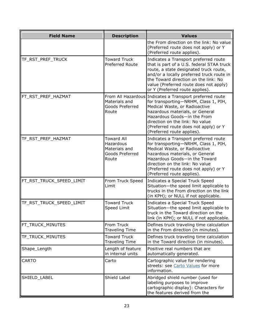
FT_RST_PREF_TRUCK From Truck
Preferred Route
Indicates a Transport preferred route
that is part of a U.S. federal STAA truck
route, a state designated truck route,
and/or a locally preferred truck route in
23
Field Name Description Values
the From direction on the link: No value
(Preferred route does not apply) or Y
(Preferred route applies).
TF_RST_PREF_TRUCK Toward Truck
Preferred Route
Indicates a Transport preferred route
that is part of a U.S. federal STAA truck
route, a state designated truck route,
and/or a locally preferred truck route in
the Toward direction on the link: No
value (Preferred route does not apply)
or Y (Preferred route applies).
FT_RST_PREF_HAZMAT From All Hazardous
Materials and
Goods Preferred
Route
Indicates a Transport preferred route
for transporting—NRHM, Class 1, PIH,
Medical Waste, or Radioactive
hazardous materials, or General
Hazardous Goods—in the From
direction on the link: No value
(Preferred route does not apply) or Y
(Preferred route applies).
TF_RST_PREF_HAZMAT Toward All
Hazardous
Materials and
Goods Preferred
Route
Indicates a Transport preferred route
for transporting—NRHM, Class 1, PIH,
Medical Waste, or Radioactive
hazardous materials, or General
Hazardous Goods—in the Toward
direction on the link: No value
(Preferred route does not apply) or Y
(Preferred route applies).
FT_RST_TRUCK_SPEED_LIMIT From Truck Speed
Limit
Indicates a Special Truck Speed
Situation—the speed limit applicable to
trucks in the From direction on the link
(in KPH); or NULL if not applicable.
TF_RST_TRUCK_SPEED_LIMIT Toward Truck
Speed Limit
Indicates a Special Truck Speed
Situation—the speed limit applicable to
truck in the Toward direction on the
link (in KPH); or NULL if not applicable.
FT_TRUCK_MINUTES From Truck
Traveling Time
Defines truck traveling time calculation
in the From direction (in minutes).
TF_TRUCK_MINUTES Toward Truck
Traveling Time
Defines truck traveling time calculation
in the Toward direction (in minutes).
Shape_Length Length of feature
in internal units
Positive real numbers that are
automatically generated.
CARTO Carto Cartographic value for rendering
streets: see Carto Values for more
information.
SHIELD_LABEL Shield Label Abridged shield number (used for
labeling purposes to improve
cartographic display): Characters for
the features derived from the
24
Field Name Description Values
StreetNameBase fields. Note: Priority
for selecting shield label from multiple
alternative names is based on the level
of route type and official language code
for specified country.
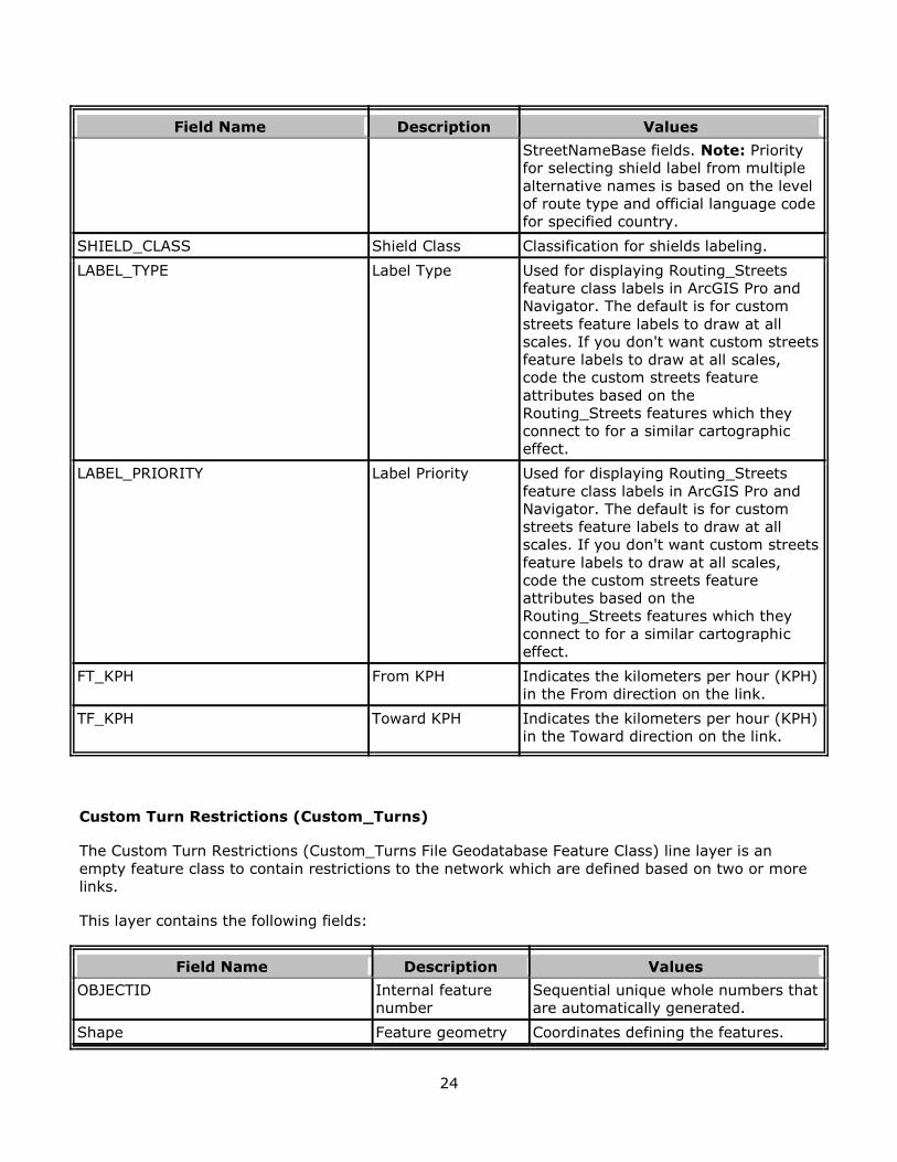
SHIELD_CLASS Shield Class Classification for shields labeling.
LABEL_TYPE Label Type Used for displaying Routing_Streets
feature class labels in ArcGIS Pro and
Navigator. The default is for custom
streets feature labels to draw at all
scales. If you don't want custom streets
feature labels to draw at all scales,
code the custom streets feature
attributes based on the
Routing_Streets features which they
connect to for a similar cartographic
effect.
LABEL_PRIORITY Label Priority Used for displaying Routing_Streets
feature class labels in ArcGIS Pro and
Navigator. The default is for custom
streets feature labels to draw at all
scales. If you don't want custom streets
feature labels to draw at all scales,
code the custom streets feature
attributes based on the
Routing_Streets features which they
connect to for a similar cartographic
effect.
FT_KPH From KPH Indicates the kilometers per hour (KPH)
in the From direction on the link.
TF_KPH Toward KPH Indicates the kilometers per hour (KPH)
in the Toward direction on the link.
Custom Turn Restrictions (Custom_Turns)
The Custom Turn Restrictions (Custom_Turns File Geodatabase Feature Class) line layer is an
empty feature class to contain restrictions to the network which are defined based on two or more
links.
This layer contains the following fields:
Field Name Description Values
OBJECTID Internal feature
number
Sequential unique whole numbers that
are automatically generated.
Shape Feature geometry Coordinates defining the features.
25
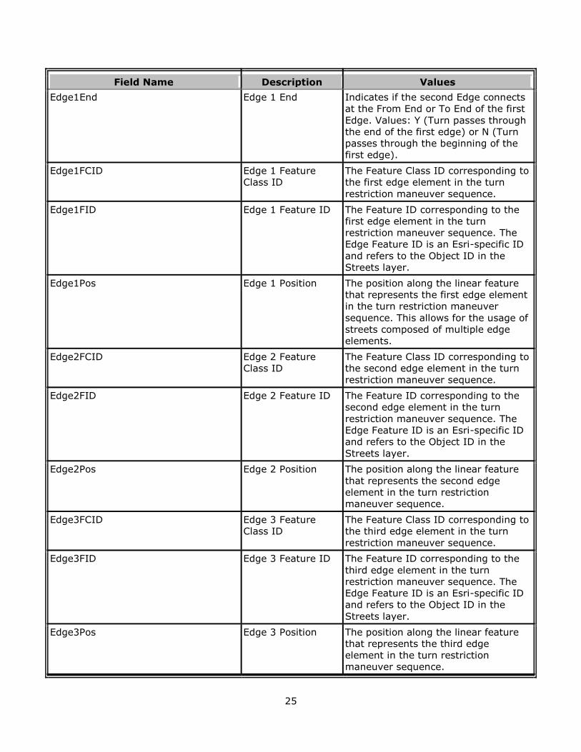
Field Name Description Values
Edge1End Edge 1 End Indicates if the second Edge connects
at the From End or To End of the first
Edge. Values: Y (Turn passes through
the end of the first edge) or N (Turn
passes through the beginning of the
first edge).
Edge1FCID Edge 1 Feature
Class ID
The Feature Class ID corresponding to
the first edge element in the turn
restriction maneuver sequence.
Edge1FID Edge 1 Feature ID The Feature ID corresponding to the
first edge element in the turn
restriction maneuver sequence. The
Edge Feature ID is an Esri-specific ID
and refers to the Object ID in the
Streets layer.
Edge1Pos Edge 1 Position The position along the linear feature
that represents the first edge element
in the turn restriction maneuver
sequence. This allows for the usage of
streets composed of multiple edge
elements.
Edge2FCID Edge 2 Feature
Class ID
The Feature Class ID corresponding to
the second edge element in the turn
restriction maneuver sequence.
Edge2FID Edge 2 Feature ID The Feature ID corresponding to the
second edge element in the turn
restriction maneuver sequence. The
Edge Feature ID is an Esri-specific ID
and refers to the Object ID in the
Streets layer.
Edge2Pos Edge 2 Position The position along the linear feature
that represents the second edge
element in the turn restriction
maneuver sequence.
Edge3FCID Edge 3 Feature
Class ID
The Feature Class ID corresponding to
the third edge element in the turn
restriction maneuver sequence.
Edge3FID Edge 3 Feature ID The Feature ID corresponding to the
third edge element in the turn
restriction maneuver sequence. The
Edge Feature ID is an Esri-specific ID
and refers to the Object ID in the
Streets layer.
Edge3Pos Edge 3 Position The position along the linear feature
that represents the third edge
element in the turn restriction
maneuver sequence.
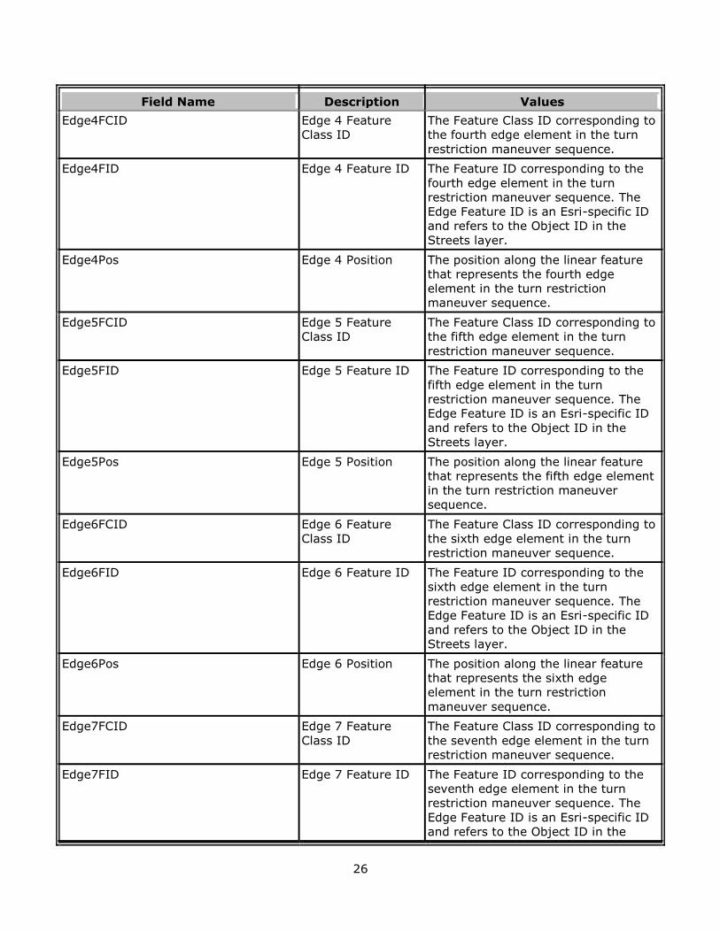
26
Field Name Description Values
Edge4FCID Edge 4 Feature
Class ID
The Feature Class ID corresponding to
the fourth edge element in the turn
restriction maneuver sequence.
Edge4FID Edge 4 Feature ID The Feature ID corresponding to the
fourth edge element in the turn
restriction maneuver sequence. The
Edge Feature ID is an Esri-specific ID
and refers to the Object ID in the
Streets layer.
Edge4Pos Edge 4 Position The position along the linear feature
that represents the fourth edge
element in the turn restriction
maneuver sequence.
Edge5FCID Edge 5 Feature
Class ID
The Feature Class ID corresponding to
the fifth edge element in the turn
restriction maneuver sequence.
Edge5FID Edge 5 Feature ID The Feature ID corresponding to the
fifth edge element in the turn
restriction maneuver sequence. The
Edge Feature ID is an Esri-specific ID
and refers to the Object ID in the
Streets layer.
Edge5Pos Edge 5 Position The position along the linear feature
that represents the fifth edge element
in the turn restriction maneuver
sequence.
Edge6FCID Edge 6 Feature
Class ID
The Feature Class ID corresponding to
the sixth edge element in the turn
restriction maneuver sequence.
Edge6FID Edge 6 Feature ID The Feature ID corresponding to the
sixth edge element in the turn
restriction maneuver sequence. The
Edge Feature ID is an Esri-specific ID
and refers to the Object ID in the
Streets layer.
Edge6Pos Edge 6 Position The position along the linear feature
that represents the sixth edge
element in the turn restriction
maneuver sequence.
Edge7FCID Edge 7 Feature
Class ID
The Feature Class ID corresponding to
the seventh edge element in the turn
restriction maneuver sequence.
Edge7FID Edge 7 Feature ID The Feature ID corresponding to the
seventh edge element in the turn
restriction maneuver sequence. The
Edge Feature ID is an Esri-specific ID
and refers to the Object ID in the
27
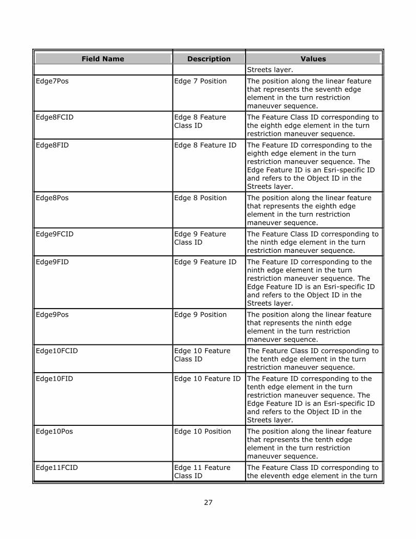
Field Name Description Values
Streets layer.
Edge7Pos Edge 7 Position The position along the linear feature
that represents the seventh edge
element in the turn restriction
maneuver sequence.
Edge8FCID Edge 8 Feature
Class ID
The Feature Class ID corresponding to
the eighth edge element in the turn
restriction maneuver sequence.
Edge8FID Edge 8 Feature ID The Feature ID corresponding to the
eighth edge element in the turn
restriction maneuver sequence. The
Edge Feature ID is an Esri-specific ID
and refers to the Object ID in the
Streets layer.
Edge8Pos Edge 8 Position The position along the linear feature
that represents the eighth edge
element in the turn restriction
maneuver sequence.
Edge9FCID Edge 9 Feature
Class ID
The Feature Class ID corresponding to
the ninth edge element in the turn
restriction maneuver sequence.
Edge9FID Edge 9 Feature ID The Feature ID corresponding to the
ninth edge element in the turn
restriction maneuver sequence. The
Edge Feature ID is an Esri-specific ID
and refers to the Object ID in the
Streets layer.
Edge9Pos Edge 9 Position The position along the linear feature
that represents the ninth edge
element in the turn restriction
maneuver sequence.
Edge10FCID Edge 10 Feature
Class ID
The Feature Class ID corresponding to
the tenth edge element in the turn
restriction maneuver sequence.
Edge10FID Edge 10 Feature ID The Feature ID corresponding to the
tenth edge element in the turn
restriction maneuver sequence. The
Edge Feature ID is an Esri-specific ID
and refers to the Object ID in the
Streets layer.
Edge10Pos Edge 10 Position The position along the linear feature
that represents the tenth edge
element in the turn restriction
maneuver sequence.
Edge11FCID Edge 11 Feature
Class ID
The Feature Class ID corresponding to
the eleventh edge element in the turn
28
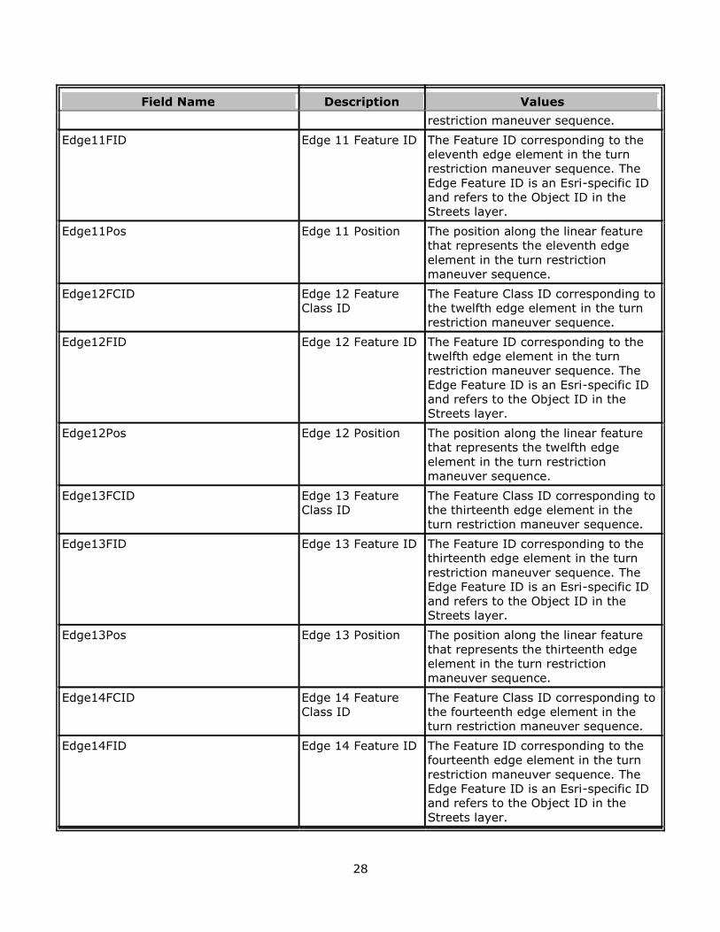
Field Name Description Values
restriction maneuver sequence.
Edge11FID Edge 11 Feature ID The Feature ID corresponding to the
eleventh edge element in the turn
restriction maneuver sequence. The
Edge Feature ID is an Esri-specific ID
and refers to the Object ID in the
Streets layer.
Edge11Pos Edge 11 Position The position along the linear feature
that represents the eleventh edge
element in the turn restriction
maneuver sequence.
Edge12FCID Edge 12 Feature
Class ID
The Feature Class ID corresponding to
the twelfth edge element in the turn
restriction maneuver sequence.
Edge12FID Edge 12 Feature ID The Feature ID corresponding to the
twelfth edge element in the turn
restriction maneuver sequence. The
Edge Feature ID is an Esri-specific ID
and refers to the Object ID in the
Streets layer.
Edge12Pos Edge 12 Position The position along the linear feature
that represents the twelfth edge
element in the turn restriction
maneuver sequence.
Edge13FCID Edge 13 Feature
Class ID
The Feature Class ID corresponding to
the thirteenth edge element in the
turn restriction maneuver sequence.
Edge13FID Edge 13 Feature ID The Feature ID corresponding to the
thirteenth edge element in the turn
restriction maneuver sequence. The
Edge Feature ID is an Esri-specific ID
and refers to the Object ID in the
Streets layer.
Edge13Pos Edge 13 Position The position along the linear feature
that represents the thirteenth edge
element in the turn restriction
maneuver sequence.
Edge14FCID Edge 14 Feature
Class ID
The Feature Class ID corresponding to
the fourteenth edge element in the
turn restriction maneuver sequence.
Edge14FID Edge 14 Feature ID The Feature ID corresponding to the
fourteenth edge element in the turn
restriction maneuver sequence. The
Edge Feature ID is an Esri-specific ID
and refers to the Object ID in the
Streets layer.
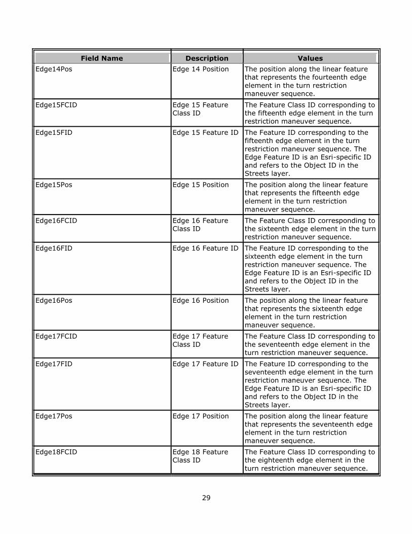
29
Field Name Description Values
Edge14Pos Edge 14 Position The position along the linear feature
that represents the fourteenth edge
element in the turn restriction
maneuver sequence.
Edge15FCID Edge 15 Feature
Class ID
The Feature Class ID corresponding to
the fifteenth edge element in the turn
restriction maneuver sequence.
Edge15FID Edge 15 Feature ID The Feature ID corresponding to the
fifteenth edge element in the turn
restriction maneuver sequence. The
Edge Feature ID is an Esri-specific ID
and refers to the Object ID in the
Streets layer.
Edge15Pos Edge 15 Position The position along the linear feature
that represents the fifteenth edge
element in the turn restriction
maneuver sequence.
Edge16FCID Edge 16 Feature
Class ID
The Feature Class ID corresponding to
the sixteenth edge element in the turn
restriction maneuver sequence.
Edge16FID Edge 16 Feature ID The Feature ID corresponding to the
sixteenth edge element in the turn
restriction maneuver sequence. The
Edge Feature ID is an Esri-specific ID
and refers to the Object ID in the
Streets layer.
Edge16Pos Edge 16 Position The position along the linear feature
that represents the sixteenth edge
element in the turn restriction
maneuver sequence.
Edge17FCID Edge 17 Feature
Class ID
The Feature Class ID corresponding to
the seventeenth edge element in the
turn restriction maneuver sequence.
Edge17FID Edge 17 Feature ID The Feature ID corresponding to the
seventeenth edge element in the turn
restriction maneuver sequence. The
Edge Feature ID is an Esri-specific ID
and refers to the Object ID in the
Streets layer.
Edge17Pos Edge 17 Position The position along the linear feature
that represents the seventeenth edge
element in the turn restriction
maneuver sequence.
Edge18FCID Edge 18 Feature
Class ID
The Feature Class ID corresponding to
the eighteenth edge element in the
turn restriction maneuver sequence.
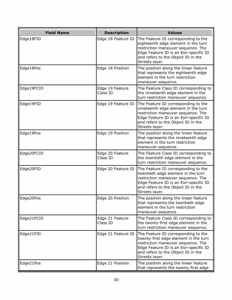
30
Field Name Description Values
Edge18FID Edge 18 Feature ID The Feature ID corresponding to the
eighteenth edge element in the turn
restriction maneuver sequence. The
Edge Feature ID is an Esri-specific ID
and refers to the Object ID in the
Streets layer.
Edge18Pos Edge 18 Position The position along the linear feature
that represents the eighteenth edge
element in the turn restriction
maneuver sequence.
Edge19FCID Edge 19 Feature
Class ID
The Feature Class ID corresponding to
the nineteenth edge element in the
turn restriction maneuver sequence.
Edge19FID Edge 19 Feature ID The Feature ID corresponding to the
nineteenth edge element in the turn
restriction maneuver sequence. The
Edge Feature ID is an Esri-specific ID
and refers to the Object ID in the
Streets layer.
Edge19Pos Edge 19 Position The position along the linear feature
that represents the nineteenth edge
element in the turn restriction
maneuver sequence.
Edge20FCID Edge 20 Feature
Class ID
The Feature Class ID corresponding to
the twentieth edge element in the
turn restriction maneuver sequence.
Edge20FID Edge 20 Feature ID The Feature ID corresponding to the
twentieth edge element in the turn
restriction maneuver sequence. The
Edge Feature ID is an Esri-specific ID
and refers to the Object ID in the
Streets layer.
Edge20Pos Edge 20 Position The position along the linear feature
that represents the twentieth edge
element in the turn restriction
maneuver sequence.
Edge21FCID Edge 21 Feature
Class ID
The Feature Class ID corresponding to
the twenty-first edge element in the
turn restriction maneuver sequence.
Edge21FID Edge 21 Feature ID The Feature ID corresponding to the
twenty-first edge element in the turn
restriction maneuver sequence. The
Edge Feature ID is an Esri-specific ID
and refers to the Object ID in the
Streets layer.
Edge21Pos Edge 21 Position The position along the linear feature
that represents the twenty-first edge
31
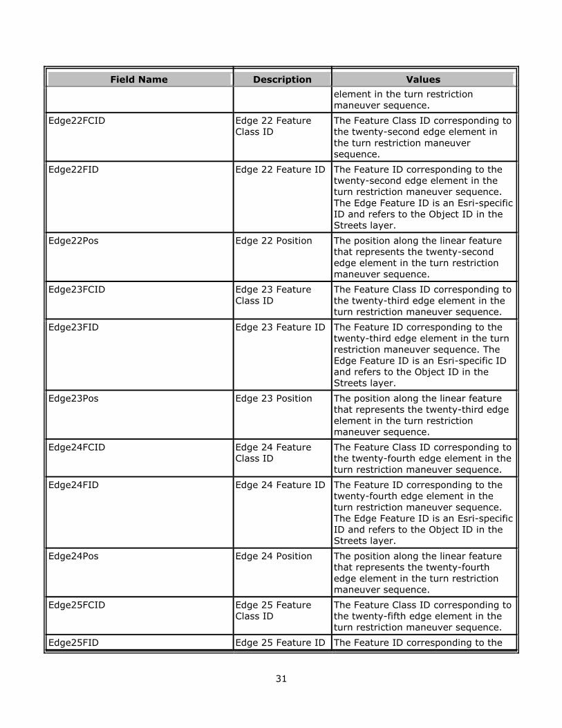
Field Name Description Values
element in the turn restriction
maneuver sequence.
Edge22FCID Edge 22 Feature
Class ID
The Feature Class ID corresponding to
the twenty-second edge element in
the turn restriction maneuver
sequence.
Edge22FID Edge 22 Feature ID The Feature ID corresponding to the
twenty-second edge element in the
turn restriction maneuver sequence.
The Edge Feature ID is an Esri-specific
ID and refers to the Object ID in the
Streets layer.
Edge22Pos Edge 22 Position The position along the linear feature
that represents the twenty-second
edge element in the turn restriction
maneuver sequence.
Edge23FCID Edge 23 Feature
Class ID
The Feature Class ID corresponding to
the twenty-third edge element in the
turn restriction maneuver sequence.
Edge23FID Edge 23 Feature ID The Feature ID corresponding to the
twenty-third edge element in the turn
restriction maneuver sequence. The
Edge Feature ID is an Esri-specific ID
and refers to the Object ID in the
Streets layer.
Edge23Pos Edge 23 Position The position along the linear feature
that represents the twenty-third edge
element in the turn restriction
maneuver sequence.
Edge24FCID Edge 24 Feature
Class ID
The Feature Class ID corresponding to
the twenty-fourth edge element in the
turn restriction maneuver sequence.
Edge24FID Edge 24 Feature ID The Feature ID corresponding to the
twenty-fourth edge element in the
turn restriction maneuver sequence.
The Edge Feature ID is an Esri-specific
ID and refers to the Object ID in the
Streets layer.
Edge24Pos Edge 24 Position The position along the linear feature
that represents the twenty-fourth
edge element in the turn restriction
maneuver sequence.
Edge25FCID Edge 25 Feature
Class ID
The Feature Class ID corresponding to
the twenty-fifth edge element in the
turn restriction maneuver sequence.
Edge25FID Edge 25 Feature ID The Feature ID corresponding to the
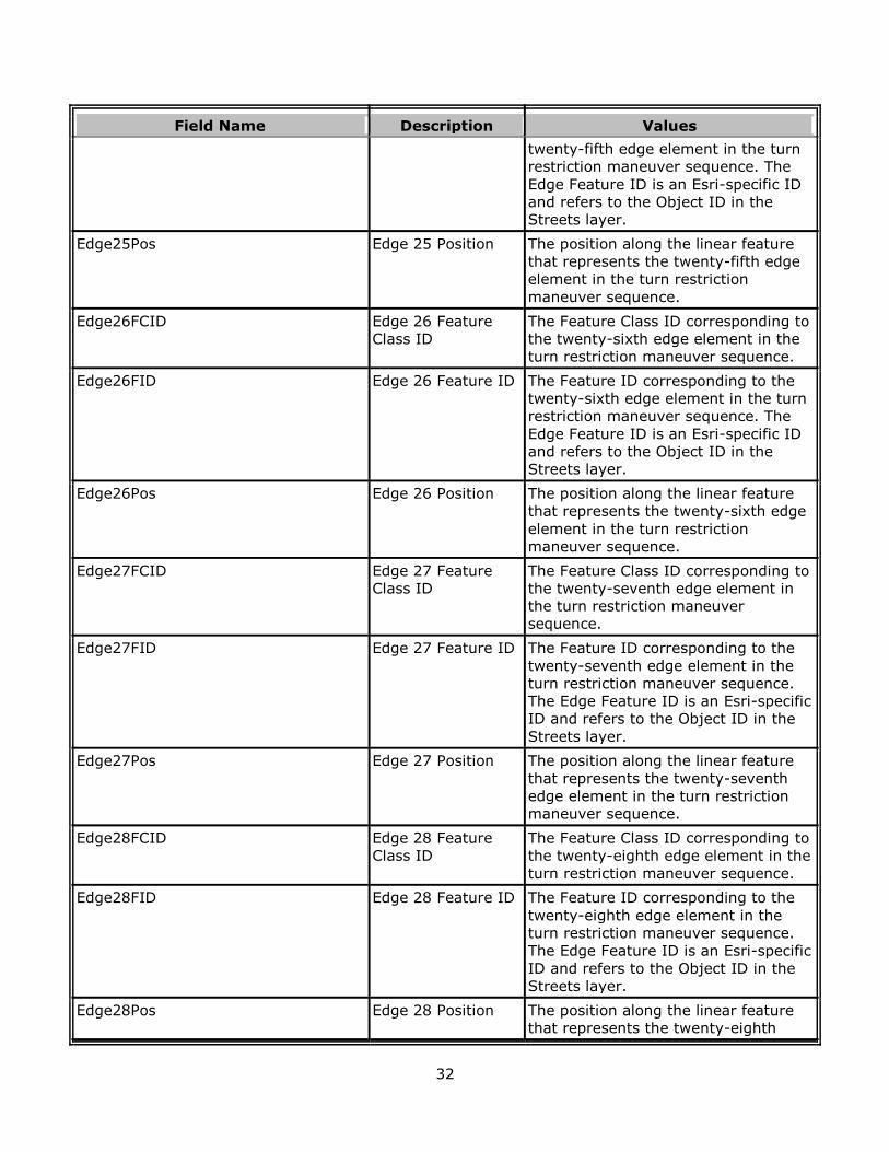
32
Field Name Description Values
twenty-fifth edge element in the turn
restriction maneuver sequence. The
Edge Feature ID is an Esri-specific ID
and refers to the Object ID in the
Streets layer.
Edge25Pos Edge 25 Position The position along the linear feature
that represents the twenty-fifth edge
element in the turn restriction
maneuver sequence.
Edge26FCID Edge 26 Feature
Class ID
The Feature Class ID corresponding to
the twenty-sixth edge element in the
turn restriction maneuver sequence.
Edge26FID Edge 26 Feature ID The Feature ID corresponding to the
twenty-sixth edge element in the turn
restriction maneuver sequence. The
Edge Feature ID is an Esri-specific ID
and refers to the Object ID in the
Streets layer.
Edge26Pos Edge 26 Position The position along the linear feature
that represents the twenty-sixth edge
element in the turn restriction
maneuver sequence.
Edge27FCID Edge 27 Feature
Class ID
The Feature Class ID corresponding to
the twenty-seventh edge element in
the turn restriction maneuver
sequence.
Edge27FID Edge 27 Feature ID The Feature ID corresponding to the
twenty-seventh edge element in the
turn restriction maneuver sequence.
The Edge Feature ID is an Esri-specific
ID and refers to the Object ID in the
Streets layer.
Edge27Pos Edge 27 Position The position along the linear feature
that represents the twenty-seventh
edge element in the turn restriction
maneuver sequence.
Edge28FCID Edge 28 Feature
Class ID
The Feature Class ID corresponding to
the twenty-eighth edge element in the
turn restriction maneuver sequence.
Edge28FID Edge 28 Feature ID The Feature ID corresponding to the
twenty-eighth edge element in the
turn restriction maneuver sequence.
The Edge Feature ID is an Esri-specific
ID and refers to the Object ID in the
Streets layer.
Edge28Pos Edge 28 Position The position along the linear feature
that represents the twenty-eighth
33
Field Name Description Values
edge element in the turn restriction
maneuver sequence.
Edge29FCID Edge 29 Feature
Class ID
The Feature Class ID corresponding to
the twenty-ninth edge element in the
turn restriction maneuver sequence.
Edge29FID Edge 29 Feature ID The Feature ID corresponding to the
twenty-ninth edge element in the turn
restriction maneuver sequence. The
Edge Feature ID is an Esri-specific ID
and refers to the Object ID in the
Streets layer.
Edge29Pos Edge 29 Position The position along the linear feature
that represents the twenty-ninth edge
element in the turn restriction
maneuver sequence.
Edge30FCID Edge 30 Feature
Class ID
The Feature Class ID corresponding to
the thirtieth edge element in the turn
restriction maneuver sequence.
Edge30FID Edge 30 Feature ID The Feature ID corresponding to the
thirtieth edge element in the turn
restriction maneuver sequence. The
Edge Feature ID is an Esri-specific ID
and refers to the Object ID in the
Streets layer.
Edge30Pos Edge 30 Position The position along the linear feature
that represents the thirtieth edge
element in the turn restriction
maneuver sequence.
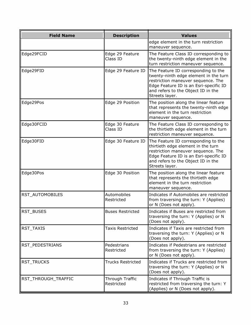
RST_AUTOMOBILES Automobiles
Restricted
Indicates if Automobiles are restricted
from traversing the turn: Y (Applies)
or N (Does not apply).
RST_BUSES Buses Restricted Indicates if Buses are restricted from
traversing the turn: Y (Applies) or N
(Does not apply).
RST_TAXIS Taxis Restricted Indicates if Taxis are restricted from
traversing the turn: Y (Applies) or N
(Does not apply).
RST_PEDESTRIANS Pedestrians
Restricted
Indicates if Pedestrians are restricted
from traversing the turn: Y (Applies)
or N (Does not apply).
RST_TRUCKS Trucks Restricted Indicates if Trucks are restricted from
traversing the turn: Y (Applies) or N
(Does not apply).
RST_THROUGH_TRAFFIC Through Traffic
Restricted
Indicates if Through Traffic is
restricted from traversing the turn: Y
(Applies) or N (Does not apply).
34
Field Name Description Values
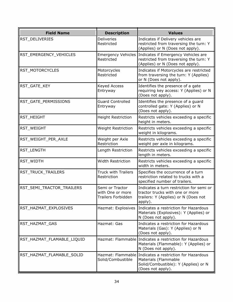
RST_DELIVERIES Deliveries
Restricted
Indicates if Delivery vehicles are
restricted from traversing the turn: Y
(Applies) or N (Does not apply).
RST_EMERGENCY_VEHICLES Emergency Vehicles
Restricted
Indicates if Emergency Vehicles are
restricted from traversing the turn: Y
(Applies) or N (Does not apply).
RST_MOTORCYCLES Motorcycles
Restricted
Indicates if Motorcycles are restricted
from traversing the turn: Y (Applies)
or N (Does not apply).
RST_GATE_KEY Keyed Access
Entryway
Identifies the presence of a gate
requiring key access: Y (Applies) or N
(Does not apply).
RST_GATE_PERMISSIONS Guard Controlled
Entryway
Identifies the presence of a guard
controlled gate: Y (Applies) or N
(Does not apply).
RST_HEIGHT Height Restriction Restricts vehicles exceeding a specific
height in meters.
RST_WEIGHT Weight Restriction Restricts vehicles exceeding a specific
weight in kilograms.
RST_WEIGHT_PER_AXLE Weight per Axle
Restriction
Restricts vehicles exceeding a specific
weight per axle in kilograms.
RST_LENGTH Length Restriction Restricts vehicles exceeding a specific
length in meters.
RST_WIDTH Width Restriction Restricts vehicles exceeding a specific
width in meters.
RST_TRUCK_TRAILERS Truck with Trailers
Restriction
Specifies the occurrence of a turn
restriction related to trucks with a
specified number of trailers.
RST_SEMI_TRACTOR_TRAILERS Semi or Tractor
with One or more
Trailers Forbidden
Indicates a turn restriction for semi or
tractor trucks with one or more
trailers: Y (Applies) or N (Does not
apply).
RST_HAZMAT_EXPLOSIVES Hazmat: Explosives Indicates a restriction for Hazardous
Materials (Explosives): Y (Applies) or
N (Does not apply).
RST_HAZMAT_GAS Hazmat: Gas Indicates a restriction for Hazardous
Materials (Gas): Y (Applies) or N
(Does not apply).
RST_HAZMAT_FLAMABLE_LIQUID Hazmat: Flammable Indicates a restriction for Hazardous
Materials (Flammable): Y (Applies) or
N (Does not apply).
RST_HAZMAT_FLAMABLE_SOLID Hazmat: Flammable
Solid/Combustible
Indicates a restriction for Hazardous
Materials (Flammable
Solid/Combustible): Y (Applies) or N
(Does not apply).
35
Field Name Description Values
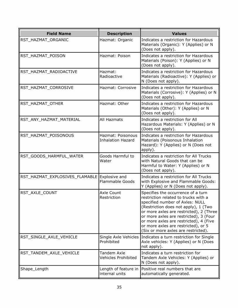
RST_HAZMAT_ORGANIC Hazmat: Organic Indicates a restriction for Hazardous
Materials (Organic): Y (Applies) or N
(Does not apply).
RST_HAZMAT_POISON Hazmat: Poison Indicates a restriction for Hazardous
Materials (Poison): Y (Applies) or N
(Does not apply).
RST_HAZMAT_RADIOACTIVE Hazmat:
Radioactive
Indicates a restriction for Hazardous
Materials (Radioactive): Y (Applies) or
N (Does not apply).
RST_HAZMAT_CORROSIVE Hazmat: Corrosive Indicates a restriction for Hazardous
Materials (Corrosive): Y (Applies) or N
(Does not apply).
RST_HAZMAT_OTHER Hazmat: Other Indicates a restriction for Hazardous
Materials (Other): Y (Applies) or N
(Does not apply).
RST_ANY_HAZMAT_MATERIAL All Hazmats Indicates a restriction for All
Hazardous Materials: Y (Applies) or N
(Does not apply).
RST_HAZMAT_POISONOUS Hazmat: Poisonous
Inhalation Hazard
Indicates a restriction for Hazardous
Materials (Poisonous Inhalation
Hazard): Y (Applies) or N (Does not
apply).
RST_GOODS_HARMFUL_WATER Goods Harmful to
Water
Indicates a restriction for All Trucks
with Natural Goods that can be
Harmful to Water: Y (Applies) or N
(Does not apply).
RST_HAZMAT_EXPLOSIVES_FLAMABLE Explosive and
Flammable Goods
Indicates a restriction for All Trucks
with Explosive and Flammable Goods:
Y (Applies) or N (Does not apply).
RST_AXLE_COUNT Axle Count
Restriction
Specifies the occurrence of a turn
restriction related to trucks with a
specified number of Axles: NULL
(Restriction does not apply), 1 (Two
or more axles are restricted), 2 (Three
or more axles are restricted), 3 (Four
or more axles are restricted), 4 (Five
or more axles are restricted), or 5
(Six or more axles are restricted).
RST_SINGLE_AXLE_VEHICLE Single Axle Vehicles
Prohibited
Indicates a turn restriction for Single
Axle vehicles: Y (Applies) or N (Does
not apply).
RST_TANDEM_AXLE_VEHICLE Tandem Axle
Vehicles Prohibited
Indicates a turn restriction for
Tandem Axle Vehicles: Y (Applies) or
N (Does not apply).
Shape_Length Length of feature in
internal units
Positive real numbers that are
automatically generated.
36
Reference
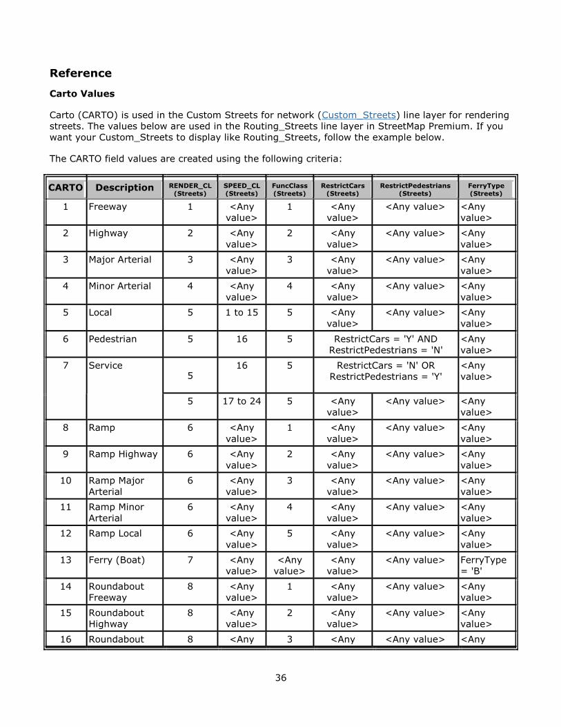
Carto Values
Carto (CARTO) is used in the Custom Streets for network (Custom_Streets) line layer for rendering
streets. The values below are used in the Routing_Streets line layer in StreetMap Premium. If you
want your Custom_Streets to display like Routing_Streets, follow the example below.
The CARTO field values are created using the following criteria:
CARTO Description RENDER_CL
(Streets)
SPEED_CL
(Streets)
FuncClass
(Streets)
RestrictCars
(Streets)
RestrictPedestrians
(Streets)
FerryType
(Streets)
1 Freeway 1 <Any
value>
1 <Any
value>
<Any value> <Any
value>
2 Highway 2 <Any
value>
2 <Any
value>
<Any value> <Any
value>
3 Major Arterial 3 <Any
value>
3 <Any
value>
<Any value> <Any
value>
4 Minor Arterial 4 <Any
value>
4 <Any
value>
<Any value> <Any
value>
5 Local 5 1 to 15 5 <Any
value>
<Any value> <Any
value>
6 Pedestrian 5 16 5 RestrictCars = 'Y' AND
RestrictPedestrians = 'N'
<Any
value>
7 Service 5
16 5 RestrictCars = 'N' OR
RestrictPedestrians = 'Y'
<Any
value>
5 17 to 24 5 <Any
value>
<Any value> <Any
value>
8 Ramp 6 <Any
value>
1 <Any
value>
<Any value> <Any
value>
9 Ramp Highway 6 <Any
value>
2 <Any
value>
<Any value> <Any
value>
10 Ramp Major
Arterial
6 <Any
value>
3 <Any
value>
<Any value> <Any
value>
11 Ramp Minor
Arterial
6 <Any
value>
4 <Any
value>
<Any value> <Any
value>
12 Ramp Local 6 <Any
value>
5 <Any
value>
<Any value> <Any
value>
13 Ferry (Boat) 7 <Any
value>
<Any
value>
<Any
value>
<Any value> FerryType
= 'B'
14 Roundabout
Freeway
8 <Any
value>
1 <Any
value>
<Any value> <Any
value>
15 Roundabout
Highway
8 <Any
value>
2 <Any
value>
<Any value> <Any
value>
16 Roundabout 8 <Any 3 <Any <Any value> <Any
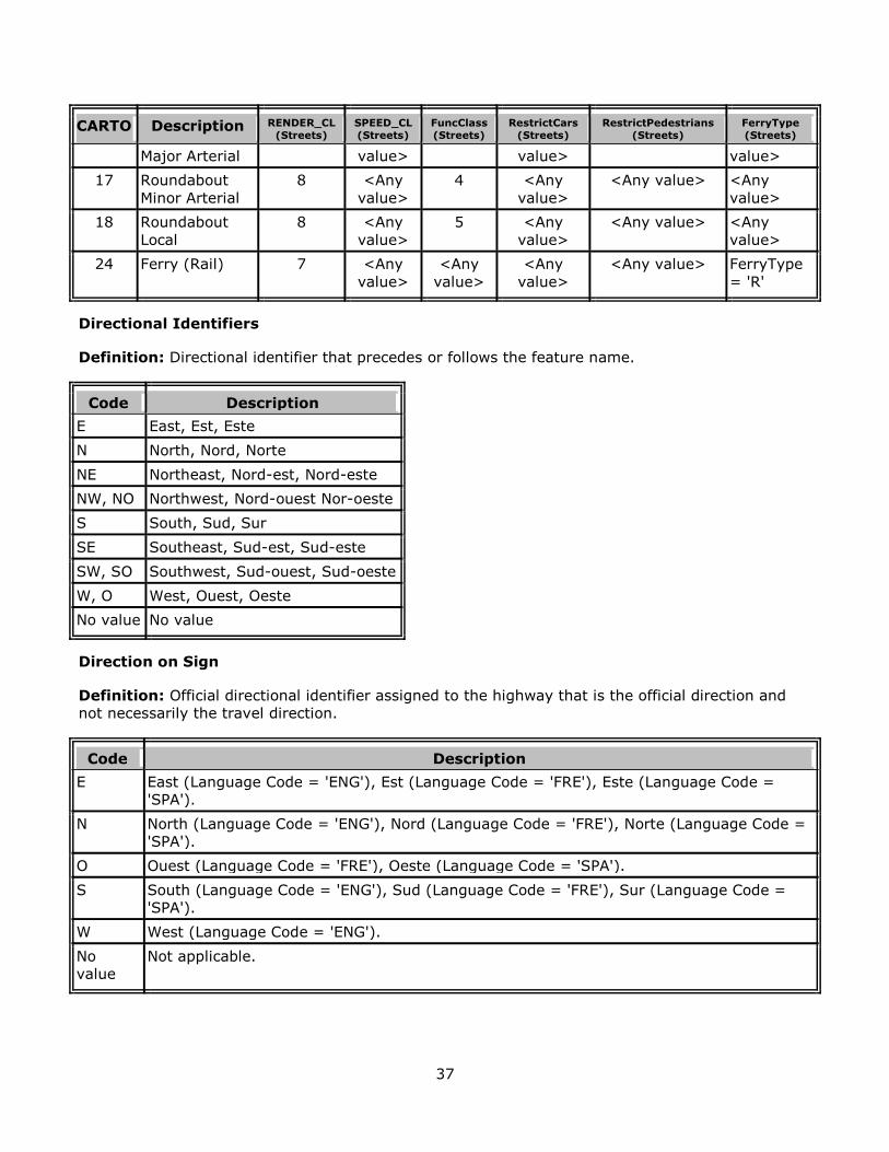
37
CARTO Description RENDER_CL
(Streets)
SPEED_CL
(Streets)
FuncClass
(Streets)
RestrictCars
(Streets)
RestrictPedestrians
(Streets)
FerryType
(Streets)
Major Arterial value> value> value>
17 Roundabout
Minor Arterial
8 <Any
value>
4 <Any
value>
<Any value> <Any
value>
18 Roundabout
Local
8 <Any
value>
5 <Any
value>
<Any value> <Any
value>
24 Ferry (Rail) 7 <Any
value>
<Any
value>
<Any
value>
<Any value> FerryType
= 'R'
Directional Identifiers
Definition: Directional identifier that precedes or follows the feature name.
Code Description
E East, Est, Este
N North, Nord, Norte
NE Northeast, Nord-est, Nord-este
NW, NO Northwest, Nord-ouest Nor-oeste
S South, Sud, Sur
SE Southeast, Sud-est, Sud-este
SW, SO Southwest, Sud-ouest, Sud-oeste
W, O West, Ouest, Oeste
No value No value
Direction on Sign
Definition: Official directional identifier assigned to the highway that is the official direction and
not necessarily the travel direction.
Code Description
E East (Language Code = 'ENG'), Est (Language Code = 'FRE'), Este (Language Code =
'SPA').
N North (Language Code = 'ENG'), Nord (Language Code = 'FRE'), Norte (Language Code =
'SPA').
O Ouest (Language Code = 'FRE'), Oeste (Language Code = 'SPA').
S South (Language Code = 'ENG'), Sud (Language Code = 'FRE'), Sur (Language Code =
'SPA').
W West (Language Code = 'ENG').
No
value
Not applicable.

38
Hierarchy
Definition: Defines a hierarchical network used to determine a logical and efficient route for a
traveler. During hierarchical analyses, if you want the solver to analyze your Custom_Streets in a
similar manner as Routing_Streets, follow the example below. It is important not to break
hierarchy classes, for example don’t create a road with Hierarchy = 2 connecting two roads having
Hierarchy = 1. For more information, read the hierarchy help documentation.
Code Description
1 Roads that allow for high-volume, maximum speed traffic movement between and through
major metropolitan areas. Applied to roads with very few, if any, speed changes. Access to
the road is usually controlled.
2 Roads used to channel traffic to Hierarchy = 1 roads for travel between and through cities in
the shortest amount of time. Applied to roads with very few, if any speed changes that allow
for high-volume, high-speed traffic movement.
3 Roads that interconnect Hierarchy = 2 roads and provide a high volume of traffic movement
at a lower level of mobility than Hierarchy = 2 roads.
4 Roads that provide for a high volume of traffic movement at moderate speeds between
neighborhoods. These roads connect with roads in higher hierarchy levels to collect and
distribute traffic between neighborhoods.
5 Roads that have volume and traffic movement below that of any hierarchy level. In addition,
walkways, truck only roads, bus only roads, and emergency vehicle only roads receive
Hierarchy = 5. Also includes access roads and parking lanes in North America, and roads in
marginal and illegal settlements in developing countries.
Maneuver Class
The ManeuverClass attribute identifies to the driving directions small connecting roads inside of or
adjacent to the street intersection. It is a descriptor attribute of type integer whose values are
shown in the following table:
ManeuverClass
Value
ManeuverClass
Type
Description
0 Default Default value assigned to streets outside street
intersections.
1 Intersection
Internal
Street segments internal to an intersection of double-
digitized roads.
2 Maneuver Street segments forming a turning slip lane (often found
where streets intersect at a sharp angle
Road Class
The Road Class attribute provides specific directions for different types of roads. It is a descriptor
attribute of type integer. If you want the driving directions text for your custom streets to be
formatted similarly to that of Routing_Streets, follow the example below:
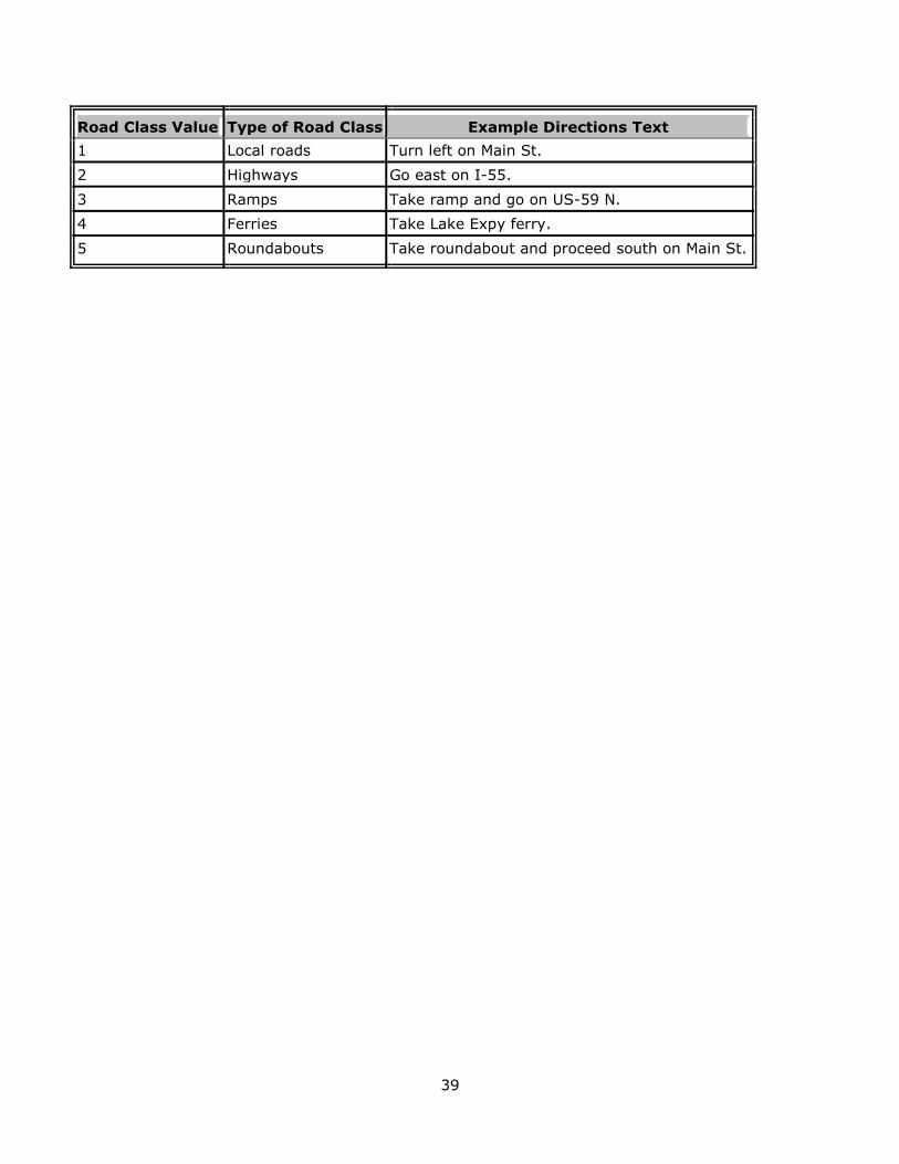
39
Road Class Value Type of Road Class Example Directions Text
1 Local roads Turn left on Main St.
2 Highways Go east on I-55.
3 Ramps Take ramp and go on US-59 N.
4 Ferries Take Lake Expy ferry.
5 Roundabouts Take roundabout and proceed south on Main St.