strathfield-homebush district historical society inc
TRANSCRIPT

p1
Strathfield-Homebush District Historical Society Inc. Website: https://strathfieldhomebushhistory.org/
Email: [email protected] 1 September 2021 The Secretary Geographical Names Board 346 Panorama Ave BATHURST NSW 2795 RE: PROPOSAL TO NAME PORTION OF BELFIELD TO STRATHFIELD SOUTH This submission is in response to the public notification by the Geographical Names Board seeking community feedback on a proposal by Strathfield Council to amend existing address locality boundaries in the Strathfield local government area (LGA). The proposal concerns renaming of a portion of the existing suburb of Belfield located in Strathfield LGA to Strathfield South. The suburb of Belfield is currently divided between two local government areas of Strathfield and City of Canterbury-Bankstown. Provided the residents who are directly affected are supportive of the proposal, the Strathfield-Homebush District Historical Society has no objections to the proposal. This submission provides commentary for consideration by the Board and has been endorsed by the Society’s Management Committee. In discussing the history of the affected areas, it should be noted that the boundaries of suburbs in the Strathfield LGA (SLGA) have shifted over time. For instance, within the current boundaries of the suburb of Strathfield South, there are localities that were formerly named at various times; Bark Huts, Druitt Town, Village of St Ann’s, Enfield and South Strathfield. Due to changes to boundaries and place names, South Strathfield Public School on Liverpool Road and the former South Strathfield Bowling Club in Augusta Street are now located in the suburb of Strathfield, not Strathfield South. The suburb of Belfield appears to have changed its boundaries also. Land located near Roberts Road and Juno Parade have been marketed as located in Belfield as well as land near the former Enfield Marshalling Yards, which is currently located in Strathfield South. There is a clear delineation between the two portions of the Belfield suburb, which is divided by Punchbowl Road. Neither
Figure 1 Belfield Estate Subdivision Map State Library of NSW
p2
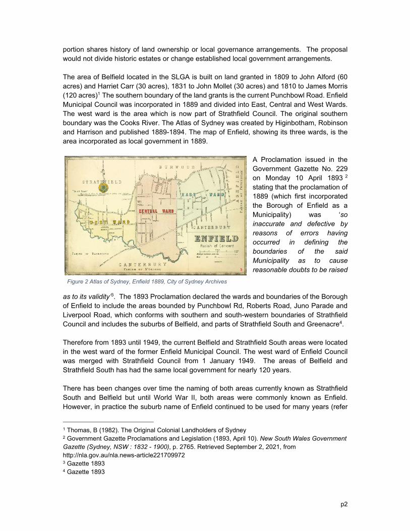
portion shares history of land ownership or local governance arrangements. The proposal would not divide historic estates or change established local government arrangements. The area of Belfield located in the SLGA is built on land granted in 1809 to John Alford (60 acres) and Harriet Carr (30 acres), 1831 to John Mollet (30 acres) and 1810 to James Morris (120 acres)1 The southern boundary of the land grants is the current Punchbowl Road. Enfield Municipal Council was incorporated in 1889 and divided into East, Central and West Wards. The west ward is the area which is now part of Strathfield Council. The original southern boundary was the Cooks River. The Atlas of Sydney was created by Higinbotham, Robinson and Harrison and published 1889-1894. The map of Enfield, showing its three wards, is the area incorporated as local government in 1889.
A Proclamation issued in the Government Gazette No. 229 on Monday 10 April 1893 2 stating that the proclamation of 1889 (which first incorporated the Borough of Enfield as a Municipality) was ‘so inaccurate and defective by reasons of errors having occurred in defining the boundaries of the said Municipality as to cause reasonable doubts to be raised
as to its validity’3. The 1893 Proclamation declared the wards and boundaries of the Borough of Enfield to include the areas bounded by Punchbowl Rd, Roberts Road, Juno Parade and Liverpool Road, which conforms with southern and south-western boundaries of Strathfield Council and includes the suburbs of Belfield, and parts of Strathfield South and Greenacre4. Therefore from 1893 until 1949, the current Belfield and Strathfield South areas were located in the west ward of the former Enfield Municipal Council. The west ward of Enfield Council was merged with Strathfield Council from 1 January 1949. The areas of Belfield and Strathfield South has had the same local government for nearly 120 years. There has been changes over time the naming of both areas currently known as Strathfield South and Belfield but until World War II, both areas were commonly known as Enfield. However, in practice the suburb name of Enfield continued to be used for many years (refer
1 Thomas, B (1982). The Original Colonial Landholders of Sydney 2 Government Gazette Proclamations and Legislation (1893, April 10). New South Wales Government Gazette (Sydney, NSW : 1832 - 1900), p. 2765. Retrieved September 2, 2021, from http://nla.gov.au/nla.news-article221709972 3 Gazette 1893 4 Gazette 1893
Figure 2 Atlas of Sydney, Enfield 1889, City of Sydney Archives

p3
Figure 3 map). For instance, the 1980 Commonwealth Electoral Roll for the Electorate of Grayndler – Subdivision of Enfield West in addition to many previous rolls, record addresses of streets such as Water Street, The Causeway, Mooney Street, Clement Street etc (currently located in the suburb of Strathfield South) in the suburb of Enfield5.
Figure 3 Wilson Sydney and Suburban Street Directory 1926
The current suburb of Enfield is a small suburb located in the Burwood Council area, the northern portion of the former central ward of Enfield Council. However, the area of Enfield once extended as far west to Roberts Road (now Greenacre), bounded by Juno Parade, Liverpool Road and Punchbowl Road. With the demise of Enfield Council in 1949, the former west ward of Enfield was melded into Strathfield Council and connections with the name Enfield has slowly, but not completely eroded from these western areas. An example is the Enfield Intermodal Logistics Centre, a key freight terminal and logistics hub, with direct connections to Port Botany to service southwestern and western Sydney. It is also referred to as Port Enfield, and built on the site of the former Enfield Marshalling Yards, which is located in the current suburb of Strathfield South. Until World War II, these areas contained considerable amounts of undeveloped residential and industrial land. From World War II, there was a significant growth of housing and population in Strathfield South and Belfield, partly as a result of NSW Government housing schemes, but also due to the post-War economic boom which expanded local industry and employment. From 1944 onwards, the NSW Government commenced resumption of undeveloped land in Belfield for housing, due to shortage of housing supply in Sydney6. One of the new houses was opened for inspection in September 19457 in Patricia Street Belfield:
5 Commonwealth Electoral Roll (1977), Electorate of Grayndler – Subdivision of Enfield West 6 Housing Act 1912 As Amended Public Works Act, 1912 As Amended. (1944, November 17). Government Gazette of the State of New South Wales (Sydney, NSW : 1901 - 2001), p. 1965. Retrieved September 1, 2021, from http://nla.gov.au/nla.news-article225099461 7 ‘Model Bungalow open today’, 1945 September 9, Truth, page 32

p4
“MODEL BUNGALOW OPEN TODAY The Bebarfald's bungalow at Patricia St., Belfield, will be open for inspection as usual today to 4.30 p.m. The bungalow, which is newly furnished by Bebarfald's, is one of the modern homes built by the N.S.W. Government Housing Commission. Visitors should take the train to Strathfield, Belmore bus to Belfield's Corner, and it is three minutes' walk to Patricia St., off Punchbowl Rd.”
One of the new public housing precincts called the ‘Belfield Housing Project’ on Blanche St, Patricia St, Cecily St and Punchbowl Road were opened by the then Minister for Housing in 1948. Land resumed for housing also included streets such as Chisholm Street, Reginald Street (now Cosgrove), Elliott St and Victory Ave. The NSW Government also resumed land in Strathfield South and Strathfield for housing in the late 1940s and 1950s. Events which led to the naming of the area currently known as the suburb of Belfield appear to be initiated from the Canterbury area. The origin of the name ‘Belfield’ is generally accepted as being constructed from the names of adjoining suburbs BEL-more and En-FIELD, however when it became commonly used is subject to some debate. Some believe that it came into usage after the opening of the Enfield Marshalling Yards in 1916, others contend that the name Belfield originated with actions of local residents to establish a local post office in 1936, where the postal inspector reported in favour of a non-official post office in his report (quoted in Madden 20028):
“…There is a business centre here consisting of sixteen shops, one garage and one Hotel. It is a prosperous business section. This part of the locality is approximately mid-way between Belmore and Enfield. It is known as Belfield”.
The business centre referenced was and is located in the Canterbury-Bankstown area.
It is uncertain when the Belfield area (SLGA) area became commonly known as Belfield. The first references to Belfield relating to areas incorporated into Enfield Council (later part of Strathfield Council) appear in representations made to Enfield Council during WWII. Representations were made by the ‘New Belfield Progress Association’ in September 1940. The next occurred in January 1942 requesting actions on the condition of Reginald Street (now Cosgrove Road) by the Belfield Branch of the Australian Labor Party (Enfield Council minutes 3 September 1940 and 27 January 1942). The area of Belfield in Canterbury-Bankstown had significant development after World War I with housing for returned servicemen9. However, the area of Belfield in SLGA remained undeveloped until World War II. However, there are also references to the older streets such as Water Street being located
8 Madden, B. (2002), History of Belfield, viewed at http://www.canterbury.nsw.gov.au/history/hisbelf.htm on 12 June 2002 9 Muir., L & Fortier, R., 2002, Belfield History and Memories, Canterbury & District Historical Society

p5
in Enfield in land records until at least the 1960s. The suburb name of Belfield was first gazetted in 1977, then 199310 and last gazetted in 1995.11
The portion of Belfield located in the Strathfield Council area measures 52 hectares or about 1km2 in land area. Strathfield South measures 256 hectares (around 3 km2)12. The total land measure of a combined area of Belfield and Strathfield South is around 300 hectares. The suburb of Strathfield is 600 hectares, which is twice the size of the proposed merged areas of Belfield and Strathfield South. Therefore, the combined size of the merged suburbs is still half the size of the suburb of Strathfield, which shares a northern border with Strathfield South. The proposed land size of the proposal should not be of concern that the suburb area will become too large. The current boundary between Belfield and Strathfield South runs along Cosgrove Road, Coxs Creek and Cooks River. The river and their foreshores is an open space corridor providing shared pathways for pedestrian and cycle access that provide connectivity between Strathfield South and Belfield. The Cooks River corridor which features the Bay to Bay shared pathway provides transport, recreation and environmental connections between both sides of the river. Road and pedestrian connections cross the river on multiple access points including Water Street, Maria Street, Madeline Street and Cosgrove Road. The Cooks River Natural Area (Bushland) Plan of Management13 maps open space on both sides of the Cooks and Cox’s Creek Rivers as a united corridor. Strathfield South has greater diversity in land use than Belfield with large areas of land zoned for industrial use (Cosgrove Road/Madeline Street precinct, Braidwood Ave/Gould Street precinct and Dunlop St/Water St) as well as residential areas. Belfield is primarily residential and has significant amounts of parks, sporting facilities and open spaces. These are attributes which are likely to add to the desirability of southern Strathfield area as a place to live. The addition of Belfield to Strathfield South would significantly increase the amount of residential, parks and open space in Strathfield South. The key commercial areas of Belfield such as shops, services and hotel are located in the Canterbury-Bankstown portion. Changing the name of Belfield should not require changes in business signage as they are located on Canterbury-Bankstown and are not affected by the proposal.
10 Geographical Names Act 1966 (1993, February 5). Government Gazette of the State of New South Wales (Sydney, NSW : 1901 - 2001), p. 357. Retrieved August 28, 2021, from http://nla.gov.au/nla.news-article231923403 11 Geographical Names Act 1966 (1995, December 1). Government Gazette of the State of New South Wales (Sydney, NSW : 1901 - 2001), p. 8131. Retrieved August 28, 2021, from http://nla.gov.au/nla.news-article231968267 12 Strathfield ID Profile, Community Profile 2021 at https://profile.id.com.au/strathfield 13 Strathfield Council 2020