stewardship plan for luther college natural areas plan for luther college natural areas ... luther...
TRANSCRIPT
Luther College Land Stewardship Plan Approved October 29, 2010
Table of Contents i
Stewardship Plan for Luther College Natural Areas Prepared by Eric Baack and Beth Lynch (Biology Department) with assistance from Jason Hagemeier (’11), Ruth Kath (Modern Languages), Lee Zieke Lee (Winneshiek County Conservation Board), Kirk Larsen (Biology Department), and Rich Tenneson (Facilities Services). Approved by Board of Regents, October 29, 2010 Table of Contents Page Part I Purpose and scope of the plan 1
Part II Northeast quadrant 6
Part III Northwest quadrant 10
Part IV Southeast quadrant 15
Part V Southwest quadrant 21
Part VI Freeport Marsh 27
Part VII Lionberger Preserve 30
Appendix I Ecological background
Appendix II Invasive plant species management
Luther College Land Stewardship Plan Approved October 29, 2010
Part I – Scope and purpose 1
Part I. Purpose and scope of the Luther College land stewardship plan Luther College mission statement:
In the reforming spirit of Martin Luther, Luther College affirms the liberating power of faith and learning. As people of all backgrounds, we embrace diversity and challenge one another to learn in community, to discern our callings, and to serve with distinction for the common good. As a college of the church, Luther is rooted in an understanding of grace and freedom that emboldens us in worship, study, and service to seek truth, examine our faith, and care for all God’s people. As a liberal arts college, Luther is committed to a way of learning that moves us beyond immediate interests and present knowledge into a larger world—an education that disciplines minds and develops whole persons equipped to understand and confront a changing society. As a residential college, Luther is a place of intersection. Founded where river, woodland, and prairie meet, we practice joyful stewardship of the resources that surround us, and we strive to be a community where students, faculty, and staff are enlivened and transformed by encounters with one another, by the exchange of ideas, and by the life of faith and learning.
As an institution Luther College has made a commitment to responsible land stewardship. Joyful stewardship of the land around the college is a key part of not only our mission statement, but also of in the Sesquicentennial Strategic Plan. Imperative III of the plan, Connecting Sustainability, Stewardship, and Global Citizenship, seeks to deepen the college's commitment to a sustainable future by creating awareness and nurturing a connection to place. Purpose The purpose of this plan is to provide direction and goals for the management of campus natural and agricultural lands not developed as part of the central campus. This includes Lionberger Preserve, Freeport Marsh, and large parts of the 800 acre main campus. Not included in this plan are the observatory property on Fox Hollow Road, the central campus, the athletic fields, Baker Village (including the planned expansion), the Ashmore-Jewell Barn, the area near the radio tower and Lindeman Pond. This plan includes all areas where biological education and biodiversity are the primary goals or could be in the future. Although this plan focuses on areas outside the central campus, the plan is consistent with and builds upon the landscape vision for the central campus. In 1911, a half-century
Luther College Land Stewardship Plan Approved October 29, 2010
Part I – Scope and purpose 2
after the college was founded on a grassy oak savanna, Luther College implemented a landscape plan developed by Danish-born, Chicago landscape artist Jens Jensen (1860-1951). The Jensen plan for Luther College reflected the prairie and savanna communities native to the site. Jensen analyzed the site for what would grow best, grouping plants as in a natural habitat, saving the century-old bur oaks and other native trees. The landscape itself was a classroom. Jensen landscaped the 32-acre site on which Luther College’s first buildings were established when the school was moved to the spot in 1865. Nearly 100 years after Jensen’s initial vision was implemented, the Luther College central campus still reflects Jens Jensen’s landscape vision for the college. This landscape of the central campus pays tribute to the natural heritage of the landscape around Luther College. Over time, the prairie and savanna surrounding the campus were lost to agriculture. This plan seeks, in part, to restore the ecological communities that inspired Jensen, and to connect the college more deeply with the surrounding landscape. Luther College’s land plays a vital role in its educational mission. The diverse ecological communities educate students in courses across disciplines, from biology to German to art. The land also develops a connection to place for members of the community who use college lands for recreation. The land and its diverse communities are important their aesthetic value. In addition to these direct services the ecological communities of the land protect the Upper Iowa River from excessive runoff, protect the soils from erosion, play key roles in cycling carbon and other nutrients, and provide habitat for hundreds of native plant and animal species. All of these services depend upon diverse, healthy ecological communities, and the continued function of these communities depends on regular monitoring and regular management (including the use of prescribed fire and removal of non-native invasive species). Without fire or mowing, our prairies will revert to forest; without attention to invasive species, diverse forests will be replaced by just a handful on invasive species. In this century, maintaining native species and communities requires individuals actively caring for the land, and this care, in turn, is deeply educational. Land stewardship goals The primary goals of land use activities on the campus natural areas are:
• To support the educational mission of the college, • To nurture a connection with place by providing opportunities to explore, enjoy,
care for, and contemplate the natural world, • To fulfill our responsibility as land stewards by sustaining and restoring the
ecological communities placed in our care.
The purpose of this plan is to describe the past and current condition of undeveloped lands owned by the college, lay out specific goals and objectives for each area, and to describe management activities necessary to achieve those objectives.
Luther College Land Stewardship Plan Approved October 29, 2010
Part I – Scope and purpose 3
Specific stewardship goals are informed by the natural and cultural history of this place as well as the broader landscape context. The natural history provides key information about the ecological communities present in the past, and what was necessary to maintain them. Habitat goals in this plan are informed by ecological knowledge of this place and are not driven primarily by aesthetic preferences. Prior to European settlement, the landscape around Decorah was a mixture of prairies in the wide river bottoms and broad uplands, diverse floodplain forests along river corridors, rich maple-basswood-red oak forests on north-facing slopes, oak-hickory forests on south-facing slopes, and extensive open oak woodlands and savannas. Fire, from lightning and intentional burning by Native Americans, was essential in maintaining prairie, savanna, and woodland communities. These plant communities slowed the runoff of water and nutrients to the rivers. As a result, floods peaked and receded more slowly. The river banks were gentle rather than deeply cut as they are today, and the flood plains supported wetlands and wet prairies. A look at the broader ecological context shows how Luther's lands fit in the landscape of north-eastern Iowa. There are opportunities to manage Luther lands in ways that enhance the ecological sustainability of the entire region. For example, many species of migratory song birds require large forest tracts for nesting habitat; there are opportunities on our campus to contribute to the recovery of these habitats. Similarly, Luther can play (and has played) an important role in protecting the water quality of the Upper Iowa River by engaging in good land stewardship. The cultural history of the land informs us about how humans have interacted with the landscape to create what we see today, and may also inform our goals for restoration. Some human impacts (such as the use of fire) have a long history in our area and may be useful management tools; some agricultural practices may create aesthetically pleasing and ecologically functional landscapes that we wish to perpetuate on some parts of the landscape. The landscape we see today is a product of the natural and cultural history of this place. Following Euro-American settlement, the prairies were plowed and forests logged. The loss of fire led to an increase in tree species that do not tolerate fire such as walnut, elm, black oak, and sugar maple. Savannas and woodlands filled in with these species and became closed forests. The development of farms, towns, and more recently rural housing developments have caused large blocks of habitat to be split into small fragments. Loss of prairie and forest led to erosion and more intense flooding, which cut deeper river channels with steep banks. Non-native species have benefited in this disturbed landscape. White tailed deer, once hunted to near extinction, have reached population densities far higher than they were prior to Euro-American settlement. Their preferred foods, such as many wildflowers and oak seedlings, fare poorly while other species thrive, resulting in changing species composition of the forest. Oaks, in particular, are not regenerating on the modern landscape.
Luther College Land Stewardship Plan Approved October 29, 2010
Part I – Scope and purpose 4
Some of the habitats present in 1840 cannot be rescued or recreated now. For example, wetlands created along the river would be isolated from the water table and would be quickly filled by sediments desposited after floods. However, in many cases, Luther College can restore natural processes to its land to support diverse ecological habitats including tallgrass prairie, oak savanna, oak woodland, flood plain forest, oak hickory forest, and maple-basswood-red oak forest.
Policy recommendations Several specific policies related to decisions about land use will be continued from the 1983 plan. These policies as well as some additional recommendations are:
• This plan is to be followed by the college administration in making decisions about requests for new construction, the acquiring or sale of property, and the initiation of new campus projects.
• The plan should also be followed by any individual or group planning activities that could impact the biodiversity or ecological function of the land, and include new construction (trails, buildings) or management activities (planting, harvesting, hunting, herbicide use, etc.) not prescribed in the plan.
• Changes in the land use plan may be initiated by the Board of Regents, the president, the faculty, the staff, or the student body. In all cases the Land Use Committee should review the proposed changes and compare them to the goals described in this plan and would make a recommendation to the Board of Regents through the president. If the proposed activity is deemed to be inconsistent with the goals of the plan then the proposed project should to be revised or abandoned.
In addition to establishing guidelines for proposed land uses, the plan seeks to establish mechanisms to ensure that land use projects are reviewed by the Land Use Committee, and that necessary monitoring and management activities can be accomplished.
• The Land Use Committee is charged with reviewing and approving any activities that impact the ecology of the lands described in this plan. Groups or individuals are responsible for presenting proposals for projects to the committee prior to implementation. Proposals will be reviewed by the Land Use Committee, who will also seek to learn the opinion of faculty, staff, and students.
• Monitoring and management necessary to maintain diverse habitats will be carried out by land steward and student interns under the direction of the Land Use Committee and interested faculty and staff members. Continuous monitoring of the health of the land is necessary to determine if goals are still appropriate and if they are being met. If one or both is not the case, then the goals or strategies may need to be revised. This “adaptive management” cycle of goal setting, monitoring, and revision is essential for management complex ecological systems.
Luther College Land Stewardship Plan Approved October 29, 2010
Part I – Scope and purpose 5
• This plan will be reviewed every two years by the Land Use Committee to
monitor progress towards goals, and to recommend changes in management or budget as needed to meet the goals. The Land Use Committee may request data necessary for monitoring progress from faculty and staff engaged in land management activities. Results of the review should be a reported to faculty, staff, and students.
• Every ten years the Land Use Committee will review the goals of the plan with
input from staff, faculty, students, and community representatives. Copies of the plan will be shared with appropriate regional organizations to facilitate stewardship planning and activities across regional scales.
Luther College Land Stewardship Plan Approved October 29, 2010
Part II – NE quadrant 6
Part II. NE Quadrant
Location The NE quadrant is N of Pole Line Rd. and E of US 52. This quadrant is divided into six regions: NE-1 (Hawk Hill) is the grassland at the top of the hill, NE-2 is the forested region on the slope, NE-3 is the prairie restoration between the agricultural fields and the forest, NE-4 and NE-6 are the current floodplain agricultural lands, and NE-5 is the drainage ditch that cuts through the floodplain.
The forest communities are young and have high densities of non-native invasive species. The grasslands are dominated by non-native shrubs and weeds. The proximity to campus and existing athletic facilities make this area an excellent candidate for recreation.
Goals and desired future condition
Education and research
Continue to use Hawk Hill (NE-1) for research plots.
Biodiversity and Ecosystem Services
Future restoration of upland forests. Removal of invasive species from drainage ditch and forests. Consider planting of flood plain (NE-4 & NE-6) to prairie to
enhance biodiversity and soil carbon storage.
Recreation Build trail network connecting Hawk hill to central campus and to NW quadrant.
Agricultural fields (NE-4 & NE-6) may be leased to City of Decorah for development of playing fields, running/walking trails, and parking.
Description of current condition Topography and soils The land adjacent to Pole Line Rd (NE-5 and NE-7) consists of floodplain soils of the Ion-Eitzen complex (with some Spillville and Lawson). The south-facing slope (NE-1, NE-2, and NE-3) has Fayette and Lacrescent soils, typical of upland deciduous forest. Portions of this area have thin soils with limestone exposures. The two ag fields (NE-5 and NE-7) on the floodplain are bisected by a ditch (NE-5) draining the watershed to the northeast. Hydrology The floodplain area (NE-5 and NE-7) will have standing water during wet springs. The drainage ditch (NE-6) is typically dry but can be full during heavy rains. Plant communities This area is highly disturbed as a result of agriculture, grazing, and excavation. Plant communities are young and do not provide quality habitat for native species.
Luther College Land Stewardship Plan Approved October 29, 2010
Part II – NE quadrant 7
Description of areas in the NE quadrant NE-1 (Hawk Hill; 12 acres) Current condition: The upland grassland is dominated by brome grass on the deeper soils, with some prairie plants in the thin soiled areas. Patches of crown vetch and Canada thistle are common. Two research plots have been established here and will continue to be used at least through 2015. This area has been identified as one of two sites on the Luther campus for the installation of a commercial-scale wind turbine. Houses to the east of the site could be affected by shadow flicker depending on the size of the wind turbine. Land use history: This area was grazed into the late 1980s. The portion bordering Highway 52 was excavated for fill during highway construction, leaving thin, rocky soils in places. Eric Baack established a research plot here in 2008, and a second in 2010. Future management: Continue to use for research. Monitor for invasive species, particularly Canada thistle. Consider restoration to prairie or white oak forest for increased biodiversity and possibly carbon sequestration. Compatible uses: Research plots; restoration; walking, running trails; electricity generation with commercial-scale wind turbine providing that the ecological impacts of the project are compatible with other goals for the site. Incompatible uses: Building construction, sale of land. NE-2 (35.5 acres) Current condition: This is a forested area with aspen and bur oak, and a high density of European buckthorn. Land use history: The northern portion of this forest has been present since at least the 1930s. Trees in other areas have become established after grazing ended. Future management: Establish trails for recreation. Consider forest or savanna restoration through buckthorn removal, planting of native species. Compatible uses: Recreation, woody biomass production, sustainable forestry. Incompatible uses: Building construction, sale of land. NE-3 (Aikman Prairie – 8.5 acres) Current condition: The prairie restoration (NE-3: Aikman Prairie) has been invaded by woody species in the absence of fire. Open areas are used for turkey displays in spring.
Luther College Land Stewardship Plan Approved October 29, 2010
Part II – NE quadrant 8
Land use history: This area was grazed into the 1980s. In the late 1980s, it was planted in CRP. The grassland has not been burned since 1995. Future management: Establish mowed burn breaks around grassland. Remove woody vegetation and establish regular mowing and burning to maintain open grassland / shrubland. Introduce additional prairie species and hazel (Corylus) Compatible uses: Trails, recreation. Incompatible uses: Building construction, sale of land. NE-4 (4.5 acres) Current condition: This area has an ephemeral pond and early-succession tree species. Standing water and surrounding vegetation may provide habitat for amphibians and some bird species. Land use history: Agriculture since before the 1930s. Trees have grown up since grazing on this site ended. Future land management: Maintain pond and surrounding habitat. Compatible uses: Recreation, sustainable biomass production, sustainable forestry. Incompatible uses: Building construction, sale of land. NE-5 (24.5 acres) Current condition: This area is used for agriculture, in a rotation of corn, soy, and alfalfa. Land use history: Agriculture since before the 1930s. Future land management: Many options are appropriate for this site, including continued agricultural production, development of athletic fields, prairie restoration, or production of biofuels. Compatible uses: Agriculture, athletics, sustainable biomass plantation, minimal construction necessary for athletic use and appropriate for flood plain site (eg dugout). Incompatible uses: Buildings (due to floodplain location), sale of land. NE-6 (7.5 acres)
Luther College Land Stewardship Plan Approved October 29, 2010
Part II – NE quadrant 9
Current condition: The drainage ditch is lined by early-successional tree species such as box elder, and has a high density of garlic mustard and other non-native weedy plants. Land use history: This ditch has been lined by levees since at least the 1930s to protect the agricultural land on either side. Future land management: This area has a very dense population of garlic mustard that should be controlled. Remove trees to protect levees and plant to prairie species. (This will have the added benefit of controlling garlic mustard which does not tolerate full sun or fire). The top of the levee could be an excellent trail to connect to the wooded slopes to the north (NE-2, NE-3). Compatible uses: Trail connecting central campus to NE quadrant. Incompatible uses: Building construction, sale of land. NE-7 (5.5 acres) Current condition: This area is used for annual crops, in a rotation of corn, soy, and alfalfa. Land use history: Agriculture since before the 1930s. Future land management: Many options are appropriate for this site, including continued agricultural production, development of athletic fields, prairie restoration, or production of biofuels. Compatible uses: Agriculture, athletics, sustainable biomass production, building site Incompatible uses: Sale of land
Luther College Land Stewardship Plan Approved October 29, 2010
Part III – NW quadrant 10
Part III. NW Quadrant Location. The NW quadrant is N. of Pole Line Rd and W of US 52. The quadrant is divided into six regions. NW-1 is the summit grassland with scattered hardwoods, NW-2 is the forest adjacent to US 52, NW-3 is the forest on the slope to the S of the summit, NW-4 is the plantation of conifers and hardwoods, NW-5 is the farmstead, student garden, and community garden, and NW-6 is the floodplain ag field.
Over the long-term, this area could support a large block of mature hardwood forest in the uplands with high value for biodiversity and recreation. The lowland areas could be used for community agriculture.
Goals and desired future condition.
Education and Research
Community and student gardens (NW-5). Use floodplain field available for demonstration of innovative
agricultural techniques (NW-6). Maintain faculty and community research plots (NW-1 & NW-4)
Biodiversity and Ecosystem Services
Restore contiguous native oak-hickory forest for biodiversity and potential future sustainable forest production (NW-1 & NW-4).
Protect mature hardwood forests (NW-2 & NW-3). Manage tree plantation to increase native tree diversity (NW-4). Consider protection of young trees in NW-1 or future white oak
planting.
Recreation Expand existing trail network (NW-1 – NW-4), including development of trail connections to the NE quadrant.
Description of current condition Topography and soils The lowest portion of the site, nearest Pole Line Rd, (NW-6) is alluvial in origin and is typically quite wet. Ion-Eitzen floodplain soils that are in the area under cultivation, and the slightly higher stream terrace soils (Waukee, Rockton, and Saude) are in the areas with the community and student garden plots (NW-5 and lower portion of NW-4). A portion of this area has very sandy Burkhardt soils. In NW-1, NW-2, and NW-3, the soils are Fayette and Orwood, well-drained upland soils that developed under forests.
Hydrology Upland areas of the NW quadrant are well-drained (NW-1-NW-5). A former stock pond (Leopold Pond) was constructed near US 52 but no longer holds water. In the past the pond supported salamander populations studied by biology classes. Consultation with NRCS staff suggests that it would not be easy to restore the pond.
Luther College Land Stewardship Plan Approved October 29, 2010
Part III – NW quadrant 11
NW-6 is subject to occasional flooding, and moisture is typically within six feet of the surface at all times of the year. Plant communities Several distinct communities occur in the NW quadrant. High quality mature forests occur in NW-2 and NW-3. Other areas are plantations of conifers or mixed conifers and hardwoods (NW-4 – Roslien Woods). The top of the ridge (NW-1) is a mixture of brome and reed canary grass, and planted hardwoods. Three research plots are located here. Portions of this quadrant (NW-4) have high densities honeysuckle and buckthorn.
Archeaological sites A tombstone and possible burial are located at the western edge of NW-4. The summit of the hill in NW-1 and the apron at the transition between NW-4 and NW-5 are likely to have sites.
Description of areas in the NW quadrant
NW-1 (20 acres)
Current conditions. This area has a dense sod of brome with patches of reed canary grass. Young oaks and walnuts grow in low density. It is terraced with grass waterways and tile outlets. Some trees are succeeding, but many are growing slowly, probably due to competition from the grasses and deer herbivory.
This area has been identified as the best site on the Luther campus for the installation of a commercial-scale wind turbine. This site presents no significant noise or shadow flicker issues. Depending on the location of the road, construction of the facility could have a significant impact on forest connectivity, high quality forest habitat, a USFS American elm study, and potential archaeological sites.
Land use history. This area was used for corn and hay production until the mid-1980s, and it remains a dense sod of brome with patches of reed canary grass. Terraces and drainage were added in the 1970s. Red oaks, white oaks, and walnuts were planted in the 1990s. Eric Baack established sunflower research plots here in 2008.
Future management. Consider planting more white oak and controlling brome to allow establishment of young trees, with the goal of creating a large patch of forest in this quadrant. Maintain trails; work to reduce wild parsnip populations.
Compatible uses. Trails for walking, running, skiing; research plots; electricity generation with commercial-scale wind turbine providing that the ecological impacts of the project are compatible with other goals for the site.
Incompatible uses. Annual crops, building construction, sale of land.
Luther College Land Stewardship Plan Approved October 29, 2010
Part III – NW quadrant 12
NW-2: (21 acres)
Current conditions. This woodland has a mixture of hardwood species including bur oak, black oak, elm, shagbark hickory, ash, white oak, box elder, aspen and basswood.
Land use history. The eastern portion of this area is relatively undisturbed and is of high quality. The western portion was heavily grazed into the 1980s and then thinned for stand improvement in 1991.
Future management. Protect this high-quality forest from human disturbance. Monitor and remove invasive species, particularly buckthorn, honeysuckle, and garlic mustard. Add trail to increase access for recreation and education.
Compatible uses. Recreation trail; sustainable forestry.
Incompatible uses. Building construction, sale of land, clearing of forest.
NW-3: (Spilde Woods – 17 acres):
Current conditions. This forest of white, bur, and red oaks, elm, walnut, and hickory, with some conifers (Norway spruce and larch) planted along the NE edge. This is one of the best oak forests on campus. The sinkhole near the top of the forest contains large amounts of trash.
Land use history. Stand improvement for the walnuts was carried out in 1991. This forest appears to have been protected from the heavy grazing that occurred elsewhere on campus. Walnuts were seeded here by the Luther farm manager in 1963.
Future management. Protect this high-quality oak forest from human disturbances. Sustainable forestry which does not include clearcuts may be considered. Clean up trash from sinkhole. Monitor for and remove invasive species (garlic mustard, honeysuckle, and buckthorn). Add trail for increased recreational and educational access.
Compatible uses. Education, recreation, sustainable forestry which does not include clearcuts.
Incompatible uses. Clearing of forest, construction, sale of land.
NW-4 (Roslien Woods – 46 acres)
Current conditions. 62-acre plantation of mixed hardwoods and conifers. Understory is largely absent in areas due to dense shade from plantations. Saplings of Dutch-elm disease resistant are present in the NW portion of this area. Area also includes dense stands of honeysuckle and buckthorn, some of which was removed in January 2010. Areas that were not planted with trees, such as fire breaks, are dense with vetch and wild parsnip. This is a sinkhole here, at the edge of NW-3, that is filled with garbage.
Luther College Land Stewardship Plan Approved October 29, 2010
Part III – NW quadrant 13
Land use history. The former pasture experienced high amounts of soil erosion in the 1980s. Bare soil and erosion gullies were visible from the Centennial Union. The area was planted with a mixture of native hardwoods and mainly non-native conifers in 1989. The stand was thinned in the late 1990s and again January 2010 to release native hardwoods from competition. The experimental disease resistant elm plantings were established by the US Forest Service in the mid 2000s.
Future management. Continue management to encourage a diverse forest of native species. See attached DNR forest plan (Appendix III). Monitor and remove invasive species, particularly wild parsnip where it interferes with trail use. Consider managing open areas in the plantation for prairie, particularly when on sandy Burkhardt soils. Maintain current trails and develop additional for increased recreational access.
Compatible uses. Recreation, sustainable forestry.
Incompatible uses. Building construction, sale of land.
NW-5 (10 acres)
Current conditions. This is a former farmstead with sheds for Luther facilities, two old barns and a former paddock. An old farmhouse currently provides staff housing. Community garden is now using a portion of the old paddock, while the remainder is in weeds. Student gardens are adjacent to farmhouse.
Land use history. The Luther College dairy herd was kept here until the 1960s. After this time, beef cattle were grazed. Luther ended its farming operation in the early 1980s. The paddock area continued to be used for cattle from the Jewell farm until 2005, and became a community garden for faculty and staff in 2009.
Future management. Continue to use for storage and community gardens. Suggest planting of perennial cover on portions of paddock not used for garden to control weeds.
Compatible uses. Additional buildings could be erected here, including storage for facilities, an environmental learning center, or housing for students, faculty,or staff.
Incompatible uses. Commercial development, sale of land.
NW-6 (25.5 acres)
Current conditions. Currently leased and planted in corn or soy
Land use history. This area has been used for row crops at least since the 1930s.
Future management. Given the high visibility of this site, recommend that innovative agriculture be the focus here.
Luther College Land Stewardship Plan Approved October 29, 2010
Part III – NW quadrant 14
Compatible uses. Agriculture, sustainable biomass production, conversion to perennial cover for enhanced carbon sequestration. Priority should be given to agriculture with educational or ecological value.
Incompatible uses. Building construction (because of flood plain location), sale of land.
Luther College Land Stewardship Plan Approved October 29, 2010
Part IV – SE Quadrant 15
Part IV. SE Quadrant Location This includes the natural areas S of Pole Line Rd and E of US 52. The natural areas surround the main campus and athletic fields. Areas include Gateway Prairie (SE-1), Hickory Ridge Woods (SE-2), Anderson Prairie (SE-3), the forest along the E edge of US 52 (SE-4), the ag field on the W side of Valley View Rd (SE-5), the west side of the Upper Iowa River (SE-6), and the east side of the river (SE-7). Due to its accessibility, this area has the highest educational and recreational use. Increasing the educational value by restoring diverse habitats should the highest priority. Goals and desired future condition
Education and Research
Maintain biodiversity in Anderson Prairie (SE-3) and Hickory Ridge Woods (SE2) for class use, research, community education, and informal education. Restore floodplain forest and wetlands along river (SE-7).
Biodiversity and Ecosystem Services
Control invasive species in all areas. Restore oak woodland structure and species composition at the
transition between Anderson Prairie (SE-3) and Hickory Ridge Woods (SE-2).
Restore floodplain forest (SE-6 & SE-7) Sequester carbon through conversion of agricultural land (SE1 &
SE-3) to prairie. Recreation Maintain trails in Anderson Prairie (SE-3), Gateway Prairie (SE-
1), Hickory Ridge Woods (SE-2), and along the river (SE-7) for use by athletics, the Luther community, and Decorah community.
Description of current condition Topography and soils Hickory Ridge Woods (SE-2) has Nordness, Fayette-Exette, and Lacrescent soils, all of which support native forests. The Lacrescent has cobbles and a deeper A horizon than the other forest soils in Hickory Ridge Woods, suggesting it is an appropriate site for oak-woodland restoration. The upper parts of Anderson Prairie (SE-3) are mostly on Lilah-Dickinson and Dickinson sandy loam, and the middle to lower portions are on Waukee and Saude loams. The lowest portion is underlain by Marshan loam which is more poorly drained than the other soils. Gateway Prairie (SE-1), the ag field (SE-5) and the river corridors (SE-6 and SE-7) are on the floodplain with Ion-Eitzen complex soils, which are often saturated. The Hwy 52 corridor (SE-4) has Orwood and Lacrescent soils typical of upland forests.
Luther College Land Stewardship Plan Approved October 29, 2010
Part IV – SE Quadrant 16
Hydrology Intermittent streams flow through Hickory Ridge Woods. Streams have been transporting garlic mustard from a neighboring source population through Hickory Ridge Woods. Gullies continue to extend upstream. Opportunities to prevent gully extension should be investigated. Anderson Prairie (SE-3) has saturated soils where it meets College Dr. Gateway Prairie (SE-1) is in the floodplain and was flooded during the 2008 flood, resulting in the deposition of 6 inches of new sediment. The agricultural field and river corridors (SE-5, SE-6 and SE-7) are also in the floodplain but did not collect soil during the 2008 flood, probably due to the absence of perennial vegetation. The forested bluff (SE-4) is a well-drained site. Plant communities This area has diverse plant communities ranging from restored prairies to upland forests. The diverse communities found here are vital for the educational use that this area sees. Descriptions of areas in the SE quadrant SE-1 (Gateway prairie – 35.5 acres) Current condition: Gateway Prairie was planted in 2005 using a mixture of eight species of grass and 63 forbs. Bur oak saplings were planted into a portion of this area to create a savanna-like structure.
Land use history: This floodplain was used for corn, sod, and alfalfa production until 2005, when it was planted with prairie species. In 2009, this area was designed for inclusion in the Emergency Watershed Protection (EWP) permanent easement. Future management: The primary method of managing Gateway Prairie will be continued use of spring prescribed burns, some mowing, and occasional mid-summer or fall burns when research needs warrant the availability of those treatments. Reed canary grass and Canada thistle will require particular attention. Thistle can be treated with appropriately timed mowing. Reed canary grass may require application of herbicide to patches. All spraying must adhere to Luther College’s herbicide policy. Compatible uses: The EWP easement on Gateway Prairie sets limits on uses. The land may not be sold, developed (including any permanent structure) or used to grow annual crops. Haying or other harvest of perennial cover, including harvest for biofuel, would require negotiation with the easement holder. Burn breaks for management purposes may be used for recreation trails. Incompatible uses: Crop production, development, any harvesting without permission of easement holder, sale of land. SE-2 (Hickory Ridge Woods – 84 acres)
Luther College Land Stewardship Plan Approved October 29, 2010
Part IV – SE Quadrant 17
Current condition: Hickory Ridge Woods is a second growth oak-hickory forest. Native forbs typical of oak-hickory woodlands and forests, including showy orchid (Orchis spectabilis) and bloodroot (Sanguinaria candensis). The main threats to biodiversity are expanding populations of non-native invasive plant species (especially garlic mustard, buckthorn, honey suckle, barberry, and celandine) and herbivory by deer which will result in the loss of some herbaceous plant species and problems with reproduction of trees. Portions of the woods contain open-grown bur oaks indicative of savanna conditions in the past. One acre has been cleared of non-oak tree species for woodland restoration. Land use history: Erosion gullies and forest composition and structure are a result of both fire suppression and a history of grazing. Since cattle were removed from the site, the forest has filled in with invasive shrubs (primarily honeysuckle, buckthorn and barberry) and shade tolerant species of trees including elm and black walnut. A 1-mile loop hiking trail was constructed in the mid 1990s. The paved trail connecting Baker Village and Vennehjeim was constructed in the early 2000s. Erosion and gully extension continues in this area. Future management: Hickory Ridge Woods is the most accessible diverse native forest community on campus. Management should maintain habitat diversity through control of invasive species control and deer herbivory. Restoration of woodlands on portions of the site should continue as funding and expertise with restoration permit. Invasive species: The goal is maintain native species diversity by eliminating invasive plant species. Eliminate all adult garlic mustard plants annually and reduce seedling numbers. Develop a multi-year plan to eliminate mature European buckthorn, honeysuckle, and barberry plants and to reduce the number of seedlings. Continue to coordinate with neighboring land owners on Ridge Road for invasive species management. Monitor invasive celandine (Chelidonium majus) and develop a strategy for control if needed. Herbivory: Develop an effective strategy to reduce deer damage to maintain diversity of understory forbs and saplings. In particular, cage butternut, bur oak, and white oak seedlings. Restoration: In most areas, successional change from oaks and hickories to more shade-tolerant and fire-sensitive maple, basswood, and walnut will continue. The 20-acre area adjacent to Anderson Prairie and along College Dr has open-grown bur oaks appropriate for woodland restoration (50-75% cover). Over the next five years (2010-2015), introduce fire to the existing 1- acre woodland restoration and monitor vegetation response to different fire regimes, responding to invasive species as needed. Use supplemental seeding in this area after 2015 if needed to introduce native understory plant species. Expand restoration to the remaining 19 acres if the initial trial is successful. This will require outside funding for tree thinning and removal of woody debris.
Luther College Land Stewardship Plan Approved October 29, 2010
Part IV – SE Quadrant 18
Trails: Maintain existing hiking trail and monitor for erosion damage, re-routing as needed. Work with neighboring land owners to reduce runoff volume and velocity, perhaps through implementation of retention basins and rain gardens on the property above Hickory Ridge Woods. Compatible uses: Education, hiking trails, sustainable forestry that does not include clearcuts or shelterwood cuts. Incompatible uses: Sale of land, building construction, mountain biking due to highly erodable soils. SE-3 (Anderson Prairie – 28.5 acres) Current condition: Anderson Prairie is a planted tallgrass prairie. Land use history: Prior to 1988, the site was used for row crop agriculture by the college farm. In May 1988 the sloped northeastern half of the prairie was planted with a mix of 4 native grass species and a light mix of 14 native forbs when the field was entered into the CRP program to reduce severe erosion problems. In 1998, the prairie was expanded into the ‘lower half’ of the prairie (southwestern half) which was planted by the college in November 1998, with seeds of 5 native grass species and 71 species of native forbs. Anderson Prairie was dedicated by the Board of Regents on November 11, 1995 in honor of Jutta F. and H. George Anderson, the then presidential couple. Anderson Prairie was divided into 19 plots which have been burned or mowed at various intervals under the direction of Kirk Larsen and with assistance from facilities and student volunteers from the Biology Department. Future management: The primary method of managing Anderson Prairie will be continued use of spring prescribed burns, some mowing, and occasional mid-summer or fall burns when research needs warrant the availability of those treatments. Periodic mowing and spot herbicide application on stumps is needed in addition to fire to control seedlings of Japanese maples and box elders. Protect bur oak seedlings in the prairie and adjacent woodland restoration sites from deer herbivory by fencing. Replace patch of box elders and invasive shrubs in the drainage in the middle of the prairie with native hazel (Corylus americana) and other fire-tolerant woody taxa. Given the proximity of this open space to College Drive and the central campus, future core campus expansion may be take place in Anderson Prairie. Any future development should be restricted to the southern edge along Ridge Road.
Luther College Land Stewardship Plan Approved October 29, 2010
Part IV – SE Quadrant 19
Compatible uses: Restoration of native plant communities, recreation, education, research
Incompatible uses: Sale of land, annual agriculture
SE-4 (Forest along bluff – 6.5 acres)
Current condition: This is an upland mixed hardwood forest on the bluff above Valley View Road. The property is currently for sale.
Land use history: This area has been forested at least since the 1930s.
Future management: Monitor and control invasive plant species. Sustainable forestry that does not include clearcuts or shelterwood cuts may be considered. This land maintains a portion of the view from Centennial Union and Farwell and so should be managed for aesthetic considerations as well as biodiversity.
Compatible uses: Sustainable forestry; conservation easement preventing future development.
Incompatible uses: This upland property should not be sold without a permanent conservation easement.
SE-5 (6 acres) Current condition: This is a parcel of agricultural land bordering Valley View Rd. Land use history: This area has been used for row crops since the 1930s, most recently a rotation of corn, soybeans, and alfalfa. This parcel flooded in the spring of 2008.
Future management: This parcel is currently for sale. It could be used for agricultural use, or planted to perennial cover for sustainable biomass production and carbon sequestration.
Compatible uses: see above. SE-6 (west river corridor – 23 acres) Current condition: This field has most recently been used for annual crop production. In 2008, Luther entered into an agreement with Winneshiek County to have a portion of this area used for wetland restoration. In 2009, the remainder of this area was designated for inclusion in the Emergency Watershed Protection (EWP) permanent easement. Land use history: Annual crop production. Grass buffer strips were planted in the late 1980s but have since been converted to woodlands of pioneer tree species.
Luther College Land Stewardship Plan Approved October 29, 2010
Part IV – SE Quadrant 20
Future management: This area will be restored to flood plain forest as part of the EWP agreement. Management should monitor invasive plant species and promote forest diversity.
Compatible uses: Forestry for biodiversity (harvest is only with permission of easement holder) and carbon sequestration; wetland restoration.
Incompatible uses: As limited by the Emergency Watershed Protection (EWP) easement, Luther College may not sell this parcel, build on this parcel, or use it for annual agriculture.
SE-7 (east river corridor -17.5 acres)
Current condition: Low quality flood plain forest and wetlands. Trails used for athletics and recreation. Area has radio tower, river access, and material storage for facilities.
Land use history: This area was cleared for agriculture to the river edge by the 1930s.
Future management: Increase visual and physical connection of campus to river. This will include thinning forest and planting native tree and shrub species, restoring wetland habitat, and developing a canoe landing and informal gathering spaces. Consider visual screening for sand and gravel piles.
Compatible uses: Recreation, education, restoration, maintenance for aesthetics.
Incompatible uses: Building construction due to location in flood plain.
Luther College Land Stewardship Plan Approved October 29, 2010
Part V – SW Quadrant 21
Part V. SW Quadrant Location The SW quadrant includes land on both sides of the Upper Iowa River, S of Pole Line Rd and W of US 52. This includes an ag field slated for prairie restoration under the Emergency Watershed Protection (EWP) easement (SW-1), the former homestead that has been proposed for an environmental learning center (SW-2), the Hoslett Study Area (SW-3), the floodplain lands below the Norski slope, which include ag lands slated for forest restoration under the EWP easement, a former quarry pit (SW-4), and the forested Norski slopes (SW-5). Goals and desired future condition
Education and Research
Manage for diverse ecosystems adjacent to potential environmental learning center (SW-2).
Protect algific talus slope, site of long-term vegetation study. Use for research on effects of deer on native vegetation (SW-5).
Biodiversity and Ecosystem Services
Restore contiguous native forest habitat in most of this quadrant (all except SW-1 and SW-4).
Protect existing mature hardwood forest and algific talus slope (SW-5).
Manage for diverse floodplain forest (SW-3 and parts of SW-4). Restore prairie for biodiversity and carbon sequestration (SW-1).
Recreation Enhance access to river (SW-3).
Luther College Land Stewardship Plan Approved October 29, 2010
Part V – SW Quadrant 22
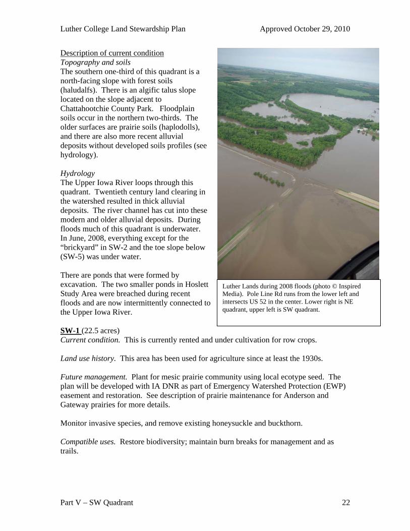
Luther Lands during 2008 floods (photo © Inspired Media). Pole Line Rd runs from the lower left and intersects US 52 in the center. Lower right is NE quadrant, upper left is SW quadrant.
Description of current condition Topography and soils The southern one-third of this quadrant is a north-facing slope with forest soils (haludalfs). There is an algific talus slope located on the slope adjacent to Chattahootchie County Park. Floodplain soils occur in the northern two-thirds. The older surfaces are prairie soils (haplodolls), and there are also more recent alluvial deposits without developed soils profiles (see hydrology). Hydrology The Upper Iowa River loops through this quadrant. Twentieth century land clearing in the watershed resulted in thick alluvial deposits. The river channel has cut into these modern and older alluvial deposits. During floods much of this quadrant is underwater. In June, 2008, everything except for the “brickyard” in SW-2 and the toe slope below (SW-5) was under water. There are ponds that were formed by excavation. The two smaller ponds in Hoslett Study Area were breached during recent floods and are now intermittently connected to the Upper Iowa River. SW-1 (22.5 acres) Current condition. This is currently rented and under cultivation for row crops. Land use history. This area has been used for agriculture since at least the 1930s. Future management. Plant for mesic prairie community using local ecotype seed. The plan will be developed with IA DNR as part of Emergency Watershed Protection (EWP) easement and restoration. See description of prairie maintenance for Anderson and Gateway prairies for more details. Monitor invasive species, and remove existing honeysuckle and buckthorn. Compatible uses. Restore biodiversity; maintain burn breaks for management and as trails.
Luther College Land Stewardship Plan Approved October 29, 2010
Part V – SW Quadrant 23
Incompatible uses. Anything prohibited by the EWP agreement, including sale of land, annual crops, pasture use, or development. Haying or harvest for biomass would require negotiation with easement holder. SW-2 (homestead – 3 acres) Current conditions. The area is currently used for storing bricks from the demolished East Side School. Invasive tree species, including black locust, are growing on the margins, along with some large, old bur oaks and cottonwoods. Future management. Maintain for possible environmental learning center. Monitor invasive species, especially garlic mustard (established along south side of Pole Line Rd) and black locust which is difficult to removed once it becomes established. Remove existing honeysuckle, buckthorn, and black locust. Compatible use. Building construction, education Incompatible uses: Sale of property SW-3 (includes Hoslett Study Area – 28 acres) Current condition. This is a second-growth floodplain forest with low quality trees (mostly box elder with some elm) and many invasive shrubs (buckthorn and honeysuckle). Very large patches of garlic mustard are present. The southeast portion of this area has more diverse trees and understory species and fewer invasive species. Stinging nettle is a prominent part of the understory, and reed canary grass is abundant. Land use history. The floodplain was in crop production or pasture by the 1930s. It appears there was grazing in open woodlands in the southern portion of the Hoslett study area. By the 1950s, the ponds at Hoslett were excavated Hoslett Research Area was dedicated in 1971, and some planting of conifers was done at that time. Future management. The Forest Stewardship Plan for the EWP restoration project submitted by IA DNR (2009) describes objectives and goals for three stands in SW-3 and SW-4. These include encouraging existing saplings of desired species and planting additional floodplain tree species to improve wildlife habitat and control erosion during major flood events. This site is currently low quality habitat and would be difficult to restore without significant investment of time and money. The best strategy would be to make small (1-3 acres) openings, plant native floodplain trees, and remove competing vegetation. Management should include monitoring and removal of invasive species (garlic mustard, honeysuckle, buckthorn), creating large canopy openings to encourage establishment of desirable floodplain species (river birch, hackberry, bur oak, etc.), and encouraging native wetland species around breached ponds. This last goal will be challenging due to the presence of reed canary grass.
Luther College Land Stewardship Plan Approved October 29, 2010
Part V – SW Quadrant 24
Regular trail maintenance is needed to increase accessibility for education and recreation. Compatible uses. Education and nature study, trails. Incompatible uses. Anything prohibited by the EWP agreement, including any construction or sale of land.
Luther College Land Stewardship Plan Approved October 29, 2010
Part V – SW Quadrant 25
SW-4 (Norski bottoms – 31 acres) Current conditions. Poor quality trees and invasive shrubs surround an old quarry pond. The southern portion is a rented field for agricultural production (2010). Both portions are to be included in the Emergency Watershed Protection (EWP) easement. The abandoned ski chalet sits in the field but will be removed by the City of Decorah (2010). Archeaological sites. This area is likely to contain an archaeological site. Land use history. The field has been in crop production since the early 1930s, with a levee already established at that time. The pond in the northern portion was created by excavation for fill during construction of Hwy 52 in the 1970s. Buffer strips along the river were planted to prairie in the 1980s(?) and enrolled in CRP. Box elder trees have since become established due to lack of maintenance. Future management The Forest Stewardship Plan for the EWP restoration project submitted by IA DNR (2009) describes objectives and goals for three stands in SW-3 and SW-4. These include encouraging existing and planting additional floodplain tree species, improving wildlife habitat, and controlling erosion during major flood events. Stand 1 (SW-4; Norski Bottoms; 12.7 acres – agricultural as of 2010). Plant mix of silver maple, river birch, swamp white oak, bur oak, red oak, basswood, and hackberry. Follow up with weed control (herbicide and regular mowing), protection from rabbits and deer. Stand 2 (SW-4; Norski Bottoms; 9.1 acres). Currently a mix of low quality trees (boxelder, elm) and invasive shrubs (European buckthorn and honeysuckle). Remove berm along river channel, and plant seedlings (bur oak, swamp white oak, hackberry, river birch) in areas of bare ground created by berm removal. Follow up with herbicide application to allow trees to become established. Maintain pond (SW-4; former quarry) edge in wild state for wildlife and educational uses. In particular, maintain vegetation around the pond for use by birds and biologists. Compatible uses. Education and nature study Incompatible uses. Anything prohibited by the EWP easement, including sale of land, annual crops, and any development. SW-5 (Norski slope – 37.5 acres) Current conditions. The north-facing slope supports a relatively young forest with a variety of hardwood species (oaks, hickories, paper birch, basswood, sugar maple, black ash, black walnut). There are relatively few invasive species. The forest in the eastern portion of this slope is more mesic (more basswood and sugar maple) and has a rich understory with spring ephemerals (including blue cohosh, false meadow rue, squirrel corn, hepatica, and bluebells). The algific talus slope at the eastern edge supports species typical of colder sites, several of which are uncommon in Iowa (alder-leaved buckthorn,
Luther College Land Stewardship Plan Approved October 29, 2010
Part V – SW Quadrant 26
red elderberry, Canada mayflower) as well as diverse fern species. The soils and rich understory in the eastern portion suggest a long history of hardwood forest on this slope. To the west, the forest composition becomes less mesic, with more oaks and hickories. The former ski runs are becoming shrubby as pioneer tree species move in. Three research plots are established here to examine the effect of deer on forest vegetation. Land use history. Formerly cleared and pastured; trees began growing on the Norski slope by the 1950s. In the early 1960s the slopes were cleared for a ski run and rope tow operated by the City of Decorah. The Nor-ski slope closed in 2003 because of a lack of reliable snow cover and the prohibitive cost of snow making equipment. Future management. The objectives are to maintain and restore hardwood forests on the slope to create a large forested areas contiguous with neighbors to the south. Algific talus slope contains several regionally rare plant taxa and should be protected from invasive species and human disturbance. Plant white and bur oaks on ski slopes where there is ample sunlight. Follow up with fencing to protect from deer and mowing to keep down competing shrubs and trees while the trees become established. Monitor and remove invasive species, particularly honeysuckle and buckthorn. Compatible uses. Education and nature study. Potential to develop trail in western portion, or trail connecting to the west-facing slope of Chattahoochie. Incompatible uses. Trail construction in eastern portion should avoid steep slope and vulnerable algific talus slope habitats. Above ground power lines, sale of land, building construction.
Luther College Land Stewardship Plan Approved October 29, 2010
Part VI – Freeport Marsh 27
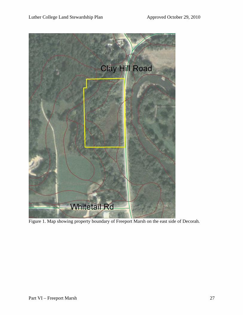
Figure 1. Map showing property boundary of Freeport Marsh on the east side of Decorah.
Luther College Land Stewardship Plan Approved October 29, 2010
Part VI – Freeport Marsh 28
Section VI: Freeport Marsh
Location: Freeport Marsh is a seven-acre site owned by the college located just north of Whitetail Road on the west side of Clay Hill Road immediately adjacent to the Upper Iowa River. This site was purchased by the college with Hoslett Field Study funds in the early 1980s because of the significant skunk cabbage, wetland plants, and planarian populations found at the site.
Goals and Desired Future Condition Biodiversity & Ecosystem Services
Protect wetland and flood-plain functioning Monitor and remove invasive species
Description of Current Conditions Freeport Marsh is a spring-fed wetland on the floodplain of the Upper Iowa River. Topography and soils Freeport Marsh is level except for a steep, east-facing slope in the western edge of the property. The soils are mainly Eitzen, with some Burkhardt and Fayette on the slopes in the NW and SW corners of the site. Hydrology There are several springs on the site which feed the marsh, and this site is located in the flood-plain of the Upper Iowa River. During spring flooding and other flood events, floodwaters will cross Clay Hill Road and completely cover the site. Drainage of the site through the culvert under Clay Hill Road is often blocked. Plant Communities Cat-tail marsh dominates the site. There is oak-hickory forest on the east-facing slope on west side of site and a pine planting on SE corner of site. Skunk cabbage is common near springs at the base of the hill on the site. Current conditions. Management of this site has been ignored by the college since Dr. Roger Knutson retired in the early 1990s, and today is used rarely by biology classes (occasionally by the Invertebrate Zoology course). Invasive species such as buckthorn and garlic mustard are now abundant.
Land use history. Due to its small size of site and difficult terrain (steep hillside and marsh), it is unlikely that much of this area has been used for any purpose. A pine plantation was planted on the SE corner of the site after the college purchased the site. The site was purchased for Dr. Roger Knutson’s research on skunk cabbage
Management Required. Invasive species are the primary concern here. Survey for garlic mustard, buckthorn, and other invasives and remove invasive plants. Remove occasional “dump piles” along Clay Hill Road.
Luther College Land Stewardship Plan Approved October 29, 2010
Part VI – Freeport Marsh 29
If Luther College wishes to retain this site, it should repair and open the parking lot which is now overgrown and clear an access trail to the springs.
Given the limited use that the college is making of this property, it may be appropriate to sell or transfer it to the Winneshiek County Conservation Board, Iowa DNR, or another agency.
Compatible uses: Manage for biodiversity and education; transfer to a government agency or conservation non-profit.
Incompatible uses: Development, agriculture.
Luther College Land Stewardship Plan Approved October 29, 2010
Part VI – Lionberger Preserve 30
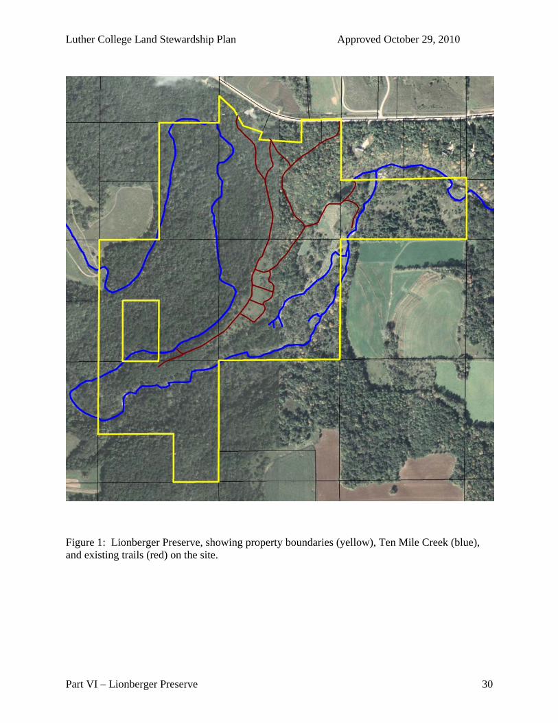
Figure 1: Lionberger Preserve, showing property boundaries (yellow), Ten Mile Creek (blue), and existing trails (red) on the site.
Luther College Land Stewardship Plan Approved October 29, 2010
Part VI – Lionberger Preserve 31
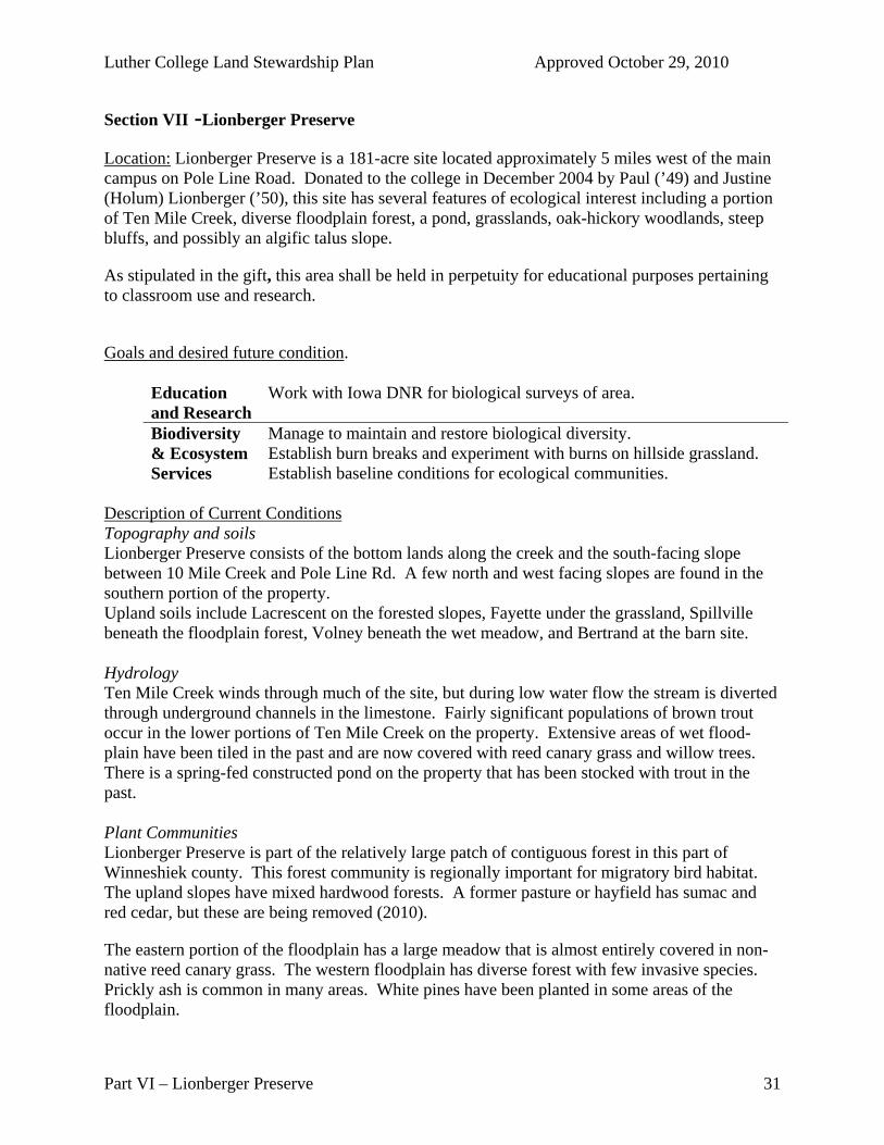
Section VII -Lionberger Preserve
Location: Lionberger Preserve is a 181-acre site located approximately 5 miles west of the main campus on Pole Line Road. Donated to the college in December 2004 by Paul (’49) and Justine (Holum) Lionberger (’50), this site has several features of ecological interest including a portion of Ten Mile Creek, diverse floodplain forest, a pond, grasslands, oak-hickory woodlands, steep bluffs, and possibly an algific talus slope.
As stipulated in the gift, this area shall be held in perpetuity for educational purposes pertaining to classroom use and research.
Goals and desired future condition.
Education and Research
Work with Iowa DNR for biological surveys of area.
Biodiversity & Ecosystem Services
Manage to maintain and restore biological diversity. Establish burn breaks and experiment with burns on hillside grassland. Establish baseline conditions for ecological communities.
Description of Current Conditions Topography and soils Lionberger Preserve consists of the bottom lands along the creek and the south-facing slope between 10 Mile Creek and Pole Line Rd. A few north and west facing slopes are found in the southern portion of the property. Upland soils include Lacrescent on the forested slopes, Fayette under the grassland, Spillville beneath the floodplain forest, Volney beneath the wet meadow, and Bertrand at the barn site. Hydrology Ten Mile Creek winds through much of the site, but during low water flow the stream is diverted through underground channels in the limestone. Fairly significant populations of brown trout occur in the lower portions of Ten Mile Creek on the property. Extensive areas of wet flood-plain have been tiled in the past and are now covered with reed canary grass and willow trees. There is a spring-fed constructed pond on the property that has been stocked with trout in the past. Plant Communities Lionberger Preserve is part of the relatively large patch of contiguous forest in this part of Winneshiek county. This forest community is regionally important for migratory bird habitat. The upland slopes have mixed hardwood forests. A former pasture or hayfield has sumac and red cedar, but these are being removed (2010).
The eastern portion of the floodplain has a large meadow that is almost entirely covered in non-native reed canary grass. The western floodplain has diverse forest with few invasive species. Prickly ash is common in many areas. White pines have been planted in some areas of the floodplain.
Luther College Land Stewardship Plan Approved October 29, 2010
Part VI – Lionberger Preserve 32
Lionberger Preserve supports a large deer population that is likely affecting forest succession. Several patches of garlic mustard that have been removed in 2008 and 2009.
Land Use History. A former honey bee yard was on top of ridge near the Lionberger home. Midway down the slope, the grassland was a pasture or hayfield. Forests on the slopes and in the floodplain appear to have been logged in the past. The upland forests are much more dense now than in the 1930s.
Archeaological sites. Two sites have been identified and registered with the State of Iowa. 13WH221 is located in a peninsular of forested floodplain in the western half of the property. Because this area appears to have had minimal disturbance it is a high priority site for future investigations. 13WH51 is located on the ridge spur (currently being managed to promote a prairie plant community) and has been more heavily impacted by past land use. Any management that does not disturb more then the upper 18” of the soil will probably not harm the site. The alluvial fan at the south end of the property is likely to also have an archaeological site.
Management Required. The site contains several dump piles from its days as a working farm, including old machinery and drainage tile. These need to be removed, and the barn should be cleaned out and secured. Keep 2-track trail from Pole Line Road to center of property open (periodically remove downed timber, etc). Erosion of this trail may need to be controlled.
Annual surveys for invasive species should be carried out, and invasive species removed regularly. If possible, remove drain tiles from riparian areas, control reed canary grass, and replace with wet native plant community.
Clear hilltop grassland areas of cedar and sumac, and maintain mowed burn breaks for periodic prescribed burning or mowing to maintain open grassland.
Consider repairing pond dam to increase pond depth by five feet.
Compatible uses. Trails for hiking; hunting and fishing the land by the members of the Lionberger family until 2030; wildlife surveys by Iowa DNR. Practice sustainable forestry without clear-cutting or shelterwood cutting to maintain diversity in tree ages and long-term forest health.
Incompatible uses: Sale of property; clear cutting any portion of forest; mortgaging the property. A lot was divided off at the time of the gift for potential sale. However, this lot is bisected by the only access to the site, so this property should not be sold without retaining the access right for students, faculty, and other biologists. Given the location of the access on the lot, this may not be possible.