stevens road master plan 7.2.07 - oregon c stevensrd_f… · stevens road tract conceptual master...
TRANSCRIPT
Stevens Road Tract Conceptual Master Plan Department of State LandsAdopted June, 2007
page 1
Adopted June, 2007
Stevens Road TractStevens Road TractConceptual Master PlanConceptual Master Plan
APPENDIX C

Adopted by: Adopted by:
THE STATE LAND BOARDTed Kulongoski - Governor
Bill Bradbury - Secretary of State
Randall Edwards - State Treasurer
Prepared by: Prepared by:
OREGON DEPARTMENT OF STATE LANDSASSET MANAGEMENT SECTIONLAND MANAGEMENT DIVISION
Louise Solliday - Director
In Conjunction with:Cogan Owens Cogan, LLC
SERA Architects, Inc.
Century West Engineering
Stevens Road TractConceptual Master Plan
Adopted June, 2007
APPENDIX C

T A B L E O F C O N T E N T S
Introduction 1
Opportunities & Constraints 3
Design Principles & Overall Objectives 4
Major Plan Elements 5
Housing 7
Employment 7
Parks & Open Space 9
School & Other Community Facilities 10
Transportation & Site Access 10
Energy Production 13
Sustainable Design & Development 13
Public Facilities and Services 14
Water & Wastewater Facilities 14
Stormwater Drainage Facilities 15
Power & Other Utilities 16
Site Remediation 16
Land Use Compatability 16
Conformance with Asset Management Plan 17
Implementation 17
UGB Recommendations 17
Refi ned Site Planning & Development 17
For More Information 18
Figures
Vicinity Map i
Master Plan 6
Road System 12
APPENDIX C

Stevens Road Tract – Vicinity Map
Bend
£¤20
Stevens Road
Tract
£¤97
£¤97
1MilesStevens Road Tract: Regional Context
[
urban growth boundary
parks
Stevens Road tract
city limits
iAPPENDIX C
Stevens Road Tract Conceptual Master Plan Department of State LandsAdopted June, 2007
page 1
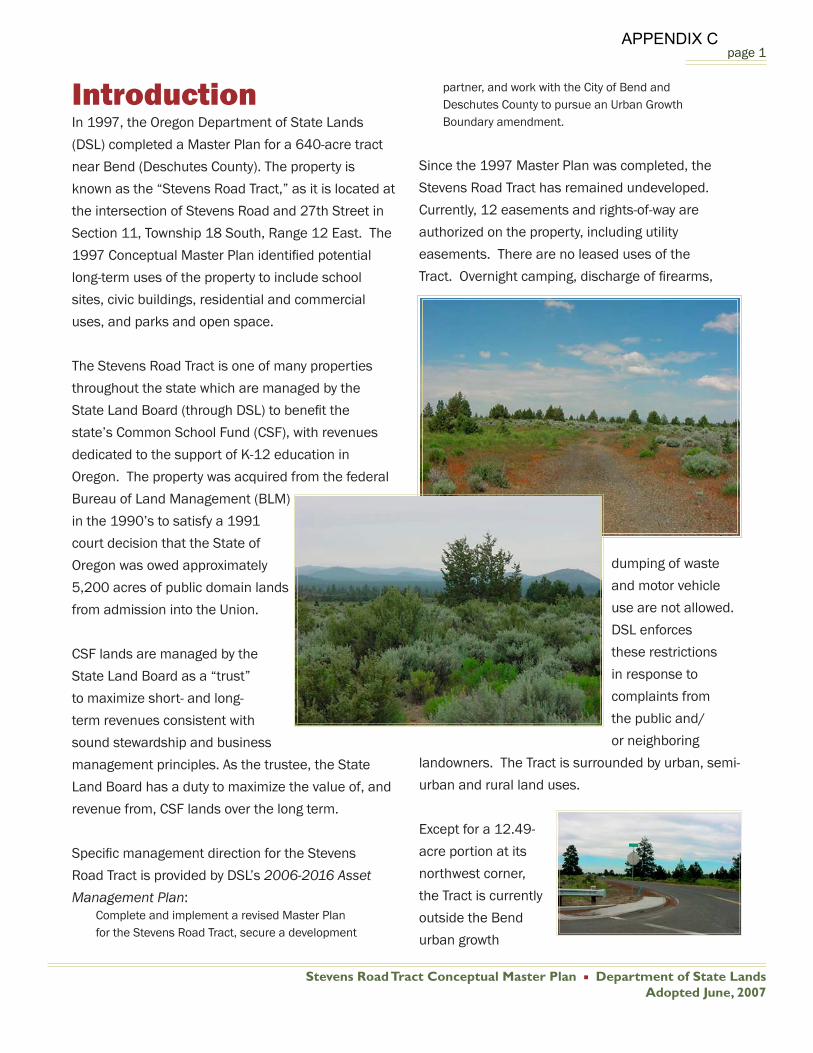
IntroductionIn 1997, the Oregon Department of State Lands
(DSL) completed a Master Plan for a 640-acre tract
near Bend (Deschutes County). The property is
known as the “Stevens Road Tract,” as it is located at
the intersection of Stevens Road and 27th Street in
Section 11, Township 18 South, Range 12 East. The
1997 Conceptual Master Plan identifi ed potential
long-term uses of the property to include school
sites, civic buildings, residential and commercial
uses, and parks and open space.
The Stevens Road Tract is one of many properties
throughout the state which are managed by the
State Land Board (through DSL) to benefi t the
state’s Common School Fund (CSF), with revenues
dedicated to the support of K-12 education in
Oregon. The property was acquired from the federal
Bureau of Land Management (BLM)
in the 1990’s to satisfy a 1991
court decision that the State of
Oregon was owed approximately
5,200 acres of public domain lands
from admission into the Union.
CSF lands are managed by the
State Land Board as a “trust”
to maximize short- and long-
term revenues consistent with
sound stewardship and business
management principles. As the trustee, the State
Land Board has a duty to maximize the value of, and
revenue from, CSF lands over the long term.
Specifi c management direction for the Stevens
Road Tract is provided by DSL’s 2006-2016 Asset Management Plan:
Complete and implement a revised Master Plan for the Stevens Road Tract, secure a development
partner, and work with the City of Bend and Deschutes County to pursue an Urban Growth Boundary amendment.
Since the 1997 Master Plan was completed, the
Stevens Road Tract has remained undeveloped.
Currently, 12 easements and rights-of-way are
authorized on the property, including utility
easements. There are no leased uses of the
Tract. Overnight camping, discharge of fi rearms,
dumping of waste
and motor vehicle
use are not allowed.
DSL enforces
these restrictions
in response to
complaints from
the public and/
or neighboring
landowners. The Tract is surrounded by urban, semi-
urban and rural land uses.
Except for a 12.49-
acre portion at its
northwest corner,
the Tract is currently
outside the Bend
urban growth
APPENDIX C

Stevens Road Tract Conceptual Master Plan Department of State LandsAdopted June, 2007
page 2
boundary (UGB) and
zoned by Deschutes
County for Exclusive
Farm Use (EFU). This
small portion of the
Tract is within the Bend
city limits and zoned for
residential use.
When DSL prepared
the initial Master Plan
in 1997, the agency did
not expect to develop
the property for urban
uses for a signifi cant period of time, given that it was
not in the City of Bend’s UGB and was not expected
to come into the boundary for more than a decade.
However, the pace of growth in the Bend area has
increased signifi cantly during the past 10 years,
increasing the likelihood that the property may be
eligible for inclusion in the UGB sooner than initially
expected. To ensure that it is prepared for that
possibility, DSL has updated its Conceptual Master
Plan to identify current proposals for future use of
the property once it is eligible for inclusion in the
UGB and annexation to the City of Bend.
Deschutes County owns a large tract of land directly
south of the DSL site. The master planning process
also addressed a portion of that property so that DSL
and the County could plan for the two areas in an
integrated manner. A proposed concept plan for that
property is described in a March, 2006 Deschutes County Tract Master Plan.
In preparing this Conceptual Master Plan, DSL
and their consultants (Cogan Owens Cogan, SERA
Architects and Century West Engineers), conducted
the following activities:
Reviewed the existing master plan and
other relevant materials, including land use
planning, park, transportation and planning
documents prepared by the BLM, City of Bend,
Deschutes County, the Oregon Department
of Environmental Quality (DEQ) and the Bend
Metro Park and Recreation District (BMPR).
Contracted a March, 2005 appraisal of the
Tract.
Conducted an opportunities and constraints
analysis.
Convened a meeting of state and local agency
representatives to discuss future land needs,
opportunities and constraints associated with
the site in June, 2005.
Conducted follow-up meetings with County and
City offi cials to discuss plans to accommodate
future growth in the Bend area.
Prepared preliminary design concepts and
reviewed and refi ned them in consultation
with DSL staff, including a design charrette
conducted on September 14, 2005.
Conducted and summarized a meeting on
November 8, 2005 with state and local agency
representatives to further review, discuss and
refi ne preliminary design concepts.
Followed up with agency representatives
to discuss specifi c topics raised during the
APPENDIX C

Stevens Road Tract Conceptual Master Plan Department of State LandsAdopted June, 2007
page 3
November 8 meeting.
Circulated a December, 2005 Preliminary Draft
Master Plan for agency review.
Consulted with the Oregon High Desert Grotto
of the National Speleological Society on cave
locations and protection measures.
Reviewed and commented on Bend’s updated
Collection System Master Plan.
Monitored Bend’s residential land needs study
and UGB amendment process, as well as
Deschutes County’s urban area reserve (UAR)
process.
Prepared an April, 2007 Draft Conceptual
Master Plan for public review and posted it on
the DSL web site.
Conducted a May 8, 2007 public meeting to
obtain input on the Conceptual Master Plan. (A
meeting summary is attached as an appendix.)
Presented a Draft Conceptual Master Plan for
adoption by the State Land Board at its June 12,
2007 meeting.
Opportunities & ConstraintsThe Stevens Road Tract represents a unique set
of opportunities for the state, the City of Bend,
Deschutes County and the community:
Generation of revenues from development of the
site to benefi t public schools statewide through
the Oregon Common School Fund.
Ability to help meet a variety of community
needs for housing, including affordable housing
opportunities, employment, parks, open space,
and other community facilities.
A single, large, vacant parcel, with relatively few
environmental constraints.
Ability to meet the housing, shopping,
recreational and employment needs of future
residents of this site and to some degree, the
surrounding area.
A location directly adjacent to the City’s existing
urban growth boundary (UGB) and to existing
developed areas; a portion of the property is
already located within the Bend UGB.
Access to existing sewer and water lines and a
major roadway with capacity for additional traffi c.
Relatively fl at topography and outstanding
views of the Cascades to the west and other
mountains to the south.
The adjacent County property represents an
opportunity to buffer future urban uses on
the DSL property from existing and future
operations at the County’s solid waste facilities
to the south.
As previously noted, the Stevens Road Tract
is currently undeveloped. It is a relatively fl at
property, with few constraints to development. Key
constraints include:
Presence of a number of caves and collapsed
lava tubes, with a sensitive bat species known to
inhabit at least some of the caves.
APPENDIX C

Stevens Road Tract Conceptual Master Plan Department of State LandsAdopted June, 2007
page 4
Historic disposal of solid and liquid waste on
approximately 40 acres of the Tract.
Irrigation canal running diagonally across the
Tract’s northwest corner.
Natural gas transmission line, with a 600-
foot buffer, running north/south through
approximately the center of the property.
Perpetual easement for electrical substation on
approximately two acres at the northeast corner
of the Tract.
Design Principles & Overall ObjectivesDSL envisions development of a “complete
community” on this site, with opportunities for
residents to live, work, shop and play in the same
area, reducing transportation and other public
facility needs. This overall approach to a self-
sustaining development will be coupled with
sustainable development design and construction
techniques to create a unique neighborhood within
the City.
Master Plan objectives and principles include:
Develop a mixture of uses that creates
opportunities for living, working, recreating
and shopping within the development, reduces
the need for automobile travel, and increases
opportunities for bicycling and walking.
Maximize revenues for the Oregon Common
School Fund through a public-private
partnership for development in accordance with
this Master Plan.
Coordinate with the City of Bend, Deschutes
County, other public agencies and citizens to
ensure that future development is consistent
and integrated with overall goals for community-
wide growth and development.
Create a mixture of housing types that meet the
needs of households with a range of incomes,
including affordable housing needs.
Coordinate development of the Stevens Road
Tract and potential uses on the County property
with long-term use of the adjacent County-
owned solid waste facilities and associated
property.
Help meet short and long-term community
needs and objectives for land use, housing, and
economic development.
Protect sensitive environmental features and
resources from the impacts of development.
Incorporate sustainable development and
design principles and practices, including but
not limited to the following:
Energy effi cient building materials and
building construction practices (e.g., energy
APPENDIX C
Stevens Road Tract Conceptual Master Plan Department of State LandsAdopted June, 2007
page 5
effi cient windows, building orientation,
high-effi ciency heating and cooling systems,
recycled building materials, etc.)
Alternative energy sources, including solar
power.
Native vegetation and other landscaping
practices that minimize irrigation needs.
Natural drainage facilities and practices
(e.g., bio-swales, detention ponds, rolled
curbs)
Permeable or semi-permeable surfaces for
low impact areas such as driveways, bike
paths or similar areas.
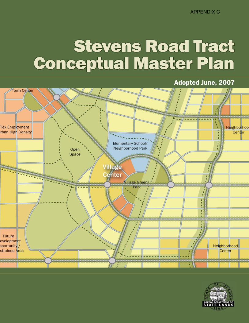
Major Plan ElementsThe Conceptual Master Plan incorporates the
following key features:
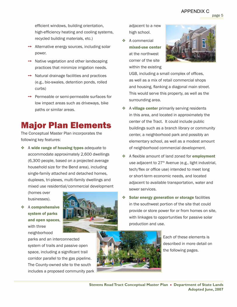
A wide range of housing types adequate to
accommodate approximately 2,600 dwellings
(6,300 people, based on a projected average
household size for the Bend area), including
single-family attached and detached homes,
duplexes, tri-plexes, multi-family dwellings and
mixed use residential/commercial development
(homes over
businesses).
A comprehensive
system of parks
and open spaces,
with three
neighborhood
parks and an interconnected
system of trails and passive open
space, including a signifi cant trail
corridor parallel to the gas pipeline.
The County-owned site to the south
includes a proposed community park
adjacent to a new
high school.
A commercial
mixed-use center
at the northwest
corner of the site
within the existing
UGB, including a small complex of offi ces,
as well as a mix of retail commercial shops
and housing, fl anking a diagonal main street.
This would serve this property, as well as the
surrounding area.
A village center primarily serving residents
in this area, and located in approximately the
center of the Tract. It could include public
buildings such as a branch library or community
center, a neighborhood park and possibly an
elementary school, as well as a modest amount
of neighborhood commercial development.
A fl exible amount of land zoned for employment
use adjacent to 27th Avenue (e.g., light industrial,
tech/fl ex or offi ce use) intended to meet long
or short-term economic needs, and located
adjacent to available transportation, water and
sewer services.
Solar energy generation or storage facilities
in the southwest portion of the site that could
provide or store power for or from homes on site,
with linkages to opportunities for passive solar
production and use.
Each of these elements is
described in more detail on
the following pages.
APPENDIX C

Stevens Road Tract Conceptual Master Plan Department of State LandsAdopted June, 2007
page 6
Stevens Road Tract – Conceptual Master Plan
APPENDIX C

Stevens Road Tract Conceptual Master Plan Department of State LandsAdopted June, 2007
page 7
HousingA signifi cant portion
of the Tract is
proposed to be
devoted to housing
(approximately
400 acres or 62.5
percent). This land
could accommodate
approximately 2,630
housing units,
assuming an average
density of about 6.6
units per acre. This is slightly higher than the target
density identifi ed in the City of Bend’s residential
land and housing needs analysis.
Housing is expected to include a mix and range
of housing types, including higher density and
multi-family housing that can help meet overall
community needs for affordable housing. It
also would be expected to meet the needs of a
variety of different types of people or households,
including families, seniors and others. As a state
agency landowner, DSL is
in a unique position to help
meet these community needs
through partnering with other
governmental agencies,
affordable housing developers
and others to help meet
affordable housing needs for
low and moderate income
families, seniors and others
who face an increasing shortage of affordable
housing.
Approximately 15 to 25 percent of residential acres
are targeted towards higher density residential
development (duplexes, tri-plexes, four-plexes and
apartments). Given the relatively higher densities
of these types of housing, that would translate into
potentially 40 percent or more of the total number
of housing units. This exceeds projected
needs identifi ed by the City of Bend in its
current residential land and housing needs
analysis.
Different housing types are proposed to be
distributed throughout the Tract. Integrating
single-family detached and other housing
units can help reduce concentrations
of multi-family housing and/or lower-income
households. At the same time, some multi-
family or higher-density housing is proposed to be
concentrated near commercial development and
potential future transit corridors to help support
future transit services and commercial businesses.
Single family housing would be located on a range
of lot sizes, though most lots would be 5,000 to
6,000 square feet or less, consistent with Bend’s
development code and in an effort to reduce land
prices associated with housing,
and to meet the projected needs of
future residents.
EmploymentRecognizing that other areas within
the community are planned to
accommodate much of the City’s
long-term employment growth
(e.g., the downtown/Central Bend
area and Juniper Ridge), employment uses are
allocated to a relatively modest proportion of the
APPENDIX C

Stevens Road Tract Conceptual Master Plan Department of State LandsAdopted June, 2007
page 8
Tract (approximately 5 to 12 percent and 35 to 85
acres). About half of this area would be devoted to
neighborhood commercial or mixed use residential/
commercial uses in four different areas within the
site. These would include:
A commercial hub is proposed at the
northwest corner of the Tract. This area would
serve residents within and outside the Stevens
Road Tract. It would include commercial and
offi ce uses, possibly incorporating a state offi ce
complex. This would help accommodate a
growing demand for state offi ce space, create
opportunities for centralized services and help
jumpstart development of commercial services
and housing on the Tract. This area also would
include a main street area, with commercial
and mixed use development area radiating to
the southeast. Neighborhood commercial uses
would provide opportunities for pedestrian and
bicycle travel for residents within ¼ to ½ mile or
more from this area.
A village center, located approximately in the
center of the Tract, would include a modest
amount of commercial development to serve
residents within the Stevens Road Tract. This
area also would include an elementary school,
park and other civic uses. It would be adjacent
to the gas line bicycle/pedestrian corridor and
bordered by higher density housing to improve
access and proximity to these services and
amenities.
Two additional, small neighborhood
commercial areas are identifi ed in the eastern
half of the site and likely to occur in later stages
of development. They also would primarily serve
residents within this area and possibly some
neighbors to the east.
In total, neighborhood commercial and mixed
use areas would account for approximately 15 to
25 acres, with the potential for 500 to 750 jobs,
assuming an average of 30 employees per acre.
Schools proposed for the Tract also would also
generate employment. A typical elementary school
includes just over 40 full time employees, while a
high school includes about 110 workers.
Flexible employment areas are proposed in the
northwest and southwest corners of the Tract.
These areas could be zoned for a mix of tech-fl ex,
offi ce, light industrial or other, similar uses to meet
short-term and long-term land needs for these
types of uses. A portion of these areas also could
function to promote live/work opportunities and
accommodate the needs of public agencies that
need larger sites to store vehicles and equipment.
They are located in areas that will be easiest to
develop in the short term and have the best access
to roads (i.e., 27th Avenue) and sewer and water
lines. Approximately 20 to 60 acres (3 to 12 percent
of the site) are designated for this type of use. This
area could be expanded or reduced, depending on
needs for this type of land identifi ed by the City as
it updates its estimates of future employment land
needs. This could translate to approximately 600
to 3,000 jobs, assuming 30 to 50 jobs per acre
(average employment density for a mix of offi ce
APPENDIX C

Stevens Road Tract Conceptual Master Plan Department of State LandsAdopted June, 2007
page 9
and tech/fl ex employment or less dense types of
employment). These uses would serve this Tract
and to some degree the entire community. They
also represent opportunities to generate long-term
revenue for the Common School Fund.
Parks & Open SpaceA signifi cant portion of the site is proposed to be
dedicated to a mix of passive and active recreation
and open space,
including paths and
trails, neighborhood
parks and passive open
space associated with
environmentally sensitive
areas. Trails will provide
both recreational opportunities for residents, as
well as routes between community uses within and
outside the Stevens Road Tract, including parks,
schools, residential and neighborhood commercial
areas. Specifi c facilities are proposed to include the
following:
Passive open space. About 160 acres of the
Tract are identifi ed for open space, in large part
to protect caves and associated bat species
located on the property. These areas would be
managed to protect these sensitive resources,
while allowing some use for passive open space
enjoyment, where feasible. DSL will prepare
a cave management plan per its commitment
to protect sensitive bat species. Conditions of
that plan will apply to any future owners of the
property.
Comprehensive trail network. A system of
trails is proposed to include a major diagonal
north/south trail along the gas transmission
line which would provide access through the
area between the centrally located civic center
and with
connections
to proposed
neighborhood
parks and
schools within
the Stevens
Road Tract. It also would link these areas to a
community park proposed for the County-owned
site to the south and an adjacent new high
school. The open space and trail network also
would connect residents within the area to an
existing middle school site to the southwest and
to possible future trail corridors along the canal
that runs through the northwest corner of the
DSL Tract. Although this canal may be moved
underground in the future, the Parks District
would still expect to create a trail easement
adjacent to it.
Neighborhood parks. Three neighborhood
parks, totaling approximately 12 to 15 acres, are
proposed, consistent with expected residential
development within the area and level of service
standards adopted by BMPR. At least one of
these parks would be co-located with a new
elementary school, providing opportunities
for shared use of school and park district
recreational facilities and potentially reducing
overall land needs for them. One of the other
parks would be located within the Village Center,
in close proximity to other community facilities
that could be located in that area (e.g., a library,
fi re station, etc.).
Community park. A community park of
approximately 25 acres in size is proposed on
the County-owned property to the south. This
park could have a broad range of facilities
and uses, possibly including but not limited
APPENDIX C

Stevens Road Tract Conceptual Master Plan Department of State LandsAdopted June, 2007
page 10
to playing fi elds, picnic shelters, paths and
walkways, play equipment, and natural areas or
open space. Location, design and development
of this and other parks would be consistent
with BMPR goals, policies and identifi ed facility
needs. The community park would help meet
park needs for the Tract
and buffer the County’s
landfi ll to the south
from residential and
commercial development
on the Stevens Road Tract.
It also would be co-located
next to a proposed high
school, also on the County-owned property,
that would serve the DSL and County-owned
properties, as well as the larger surrounding
area. The park would be located to avoid
potential impacts on surrounding properties
from lighting or other activities.
The amount of land devoted to parks and open
space would impact BMPR in terms of future
operation and maintenance needs. Detailed
planning for parks and open space will need to be
closely coordinated with BMPR to address these
issues and identify adequate means and funding
sources to operate and maintain facilities developed
on this Tract.
Schools & OtherCommunity FacilitiesDevelopment of the Stevens Road Tract will drive the
need for additional elementary schools and possibly
a middle school. Approximately 10 acres have
been identifi ed for development of an elementary
school, based on typical standards for school sizes,
the proportion of school age children, and goals for
effi cient land use and development. One
school could be located within the village
center area, along with other possible
community facilities to serve residents
(e.g., a library, fi re station, and/or small
community center). Schools would be
accessible by all modes of transportation, including
the open space and trail network proposed for the
site.
A high school is proposed for the County-owned
property to the south. As noted above, it would
serve the DSL and County-owned properties, as well
as the larger surrounding area.
No middle school sites are incorporated in the Plan,
given the close proximity to the existing middle
school site to the southwest.
Transportation & Site AccessThe Stevens Road Tract is adjacent to 27th Street
and Reed Market Road, which are major arterial
streets serving this part of Bend. Future planned
improvements to street infrastructure include
straightening of Stevens Road to connect to Reed
Market Road, and widening of Reed Market Road,
which will improve traffi c circulation to the west.
Ultimately, 27th Street may also be widened to a fi ve-
lane confi guration, which would improve circulation
to the north and south. Traffi c signalization
improvements along 27th Street also could be
needed. The location and type of improvements
APPENDIX C

Stevens Road Tract Conceptual Master Plan Department of State LandsAdopted June, 2007
page 11
would be identifi ed during future,
more detailed planning phases.
Future connections to 27th will
need to be planned in a way that
ensure adequate connectivity
to the Stevens Road site, while
minimizing impacts on congestion
along 27th.
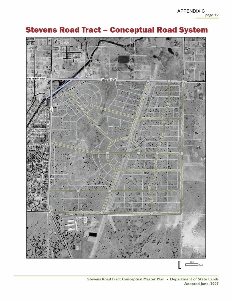
Master Plan development also
would require construction of an
internal road system of arterial, collector and local
roads, as illustrated in the map that follows. The
road system would include the following elements
and attributes:
Provide circulation within and through the
Tract, with adequate connections to adjacent
roads such as 27th Avenue, Stevens Road and
Ferguson Road. The layout and orientation of
the road network would promote connectivity
and mobility.
Create adequate east-west and north-
south through streets within the Tract to
ensure connectivity through the Tract and to
surrounding areas.
Enhance opportunities for use of alternative
modes of transportation, including bicycling,
walking and transit use. This would include
construction of bicycle lanes and sidewalks
on all major roads within the Tract, as well as
the connected system of pathways described
previously. It also would entail designation of
transit routes and stops to serve residents and
workers, particularly in higher density residential
and mixed use portions of the Tract.
Use a boulevard design for major roads, such
as the north/south diagonal road, that provides
access to the village center and possibly along
a portion of 27th Avenue, adjacent to proposed
residential development.
Design and build local neighborhood streets that
calm traffi c, encourage bicycle and pedestrian
use and improve safety.
Create street orientations that allow for
and enhance opportunities for solar power
generation and use.
Use roundabouts, where feasible. These could
provide possible locations for transit stops and
improve mobility.
Consider and address the impacts of transit,
pedestrian, bike and auto traffi c from adjacent
areas to the Stevens Road Tract.
Interior roads would connect to adjacent roads
using a combination of stop signs and signals,
where warranted to manage and control traffi c at
intersections.
The Master Plan shows the approximate location
and orientation of major roads and an example of
a local street pattern. Street designs and layouts
would be refi ned during detailed design and
development of the site, consistent with land use
patterns, traffi c analysis and City road standards.
APPENDIX C
Stevens Road Tract Conceptual Master Plan Department of State LandsAdopted June, 2007
page 12
Stevens Road Tract – Conceptual Road System
APPENDIX C
Stevens Road Tract Conceptual Master Plan Department of State LandsAdopted June, 2007
page 13
Energy ProductionAs well as supporting the overall goal of
environmental sustainability, solar energy’s
economic benefi ts are continually increasing with
advances in technology and institutional practices.
The Stevens Road Tract offers a number of unique
opportunities to employ leading-edge solar energy
production and utilization practices to enhance
environmental sustainability and create revenue-
generation opportunities. These could include
concentrated solar power generation, distributed
solar power generation, and passive solar
design. To effectively implement these strategies,
discussions with power utilities should occur early
in the planning and site development process.
A portion of the Tract (about three to 10 acres) along
the southern boundary is proposed to be used for
production of solar and possibly other alternative
energy sources (e.g., methane or other solid waste
facility by-products). A signifi cant amount of energy
could be produced within a relatively modest area
and used to support other proposed development.
In addition to exploring opportunities for solar
energy generation or use, DSL will explore use
of other potential alternative energy sources.
Consultation with the Energy Trust or similar
organizations will occur to further investigate
these issues.
In addition to a concentrated solar energy
generation facility, the homes could be built with
the option of incorporating distributed solar power
generation capabilities into roofs, possibly using
integrated solar roof tiles.
Passive solar design concepts also should be
included in the overall planning process for the
development and design of individual homes. This
would require proper orientation of the streets
from east to west as the plan indicates. It also
would entail orienting house lots north to south,
to optimize solar access and reduce shading.
Additionally, individual homes should incorporate
passive solar architectural concepts, such as
day-lighting, solar gain, thermal mass and natural
ventilation.
Sustainable Design& DevelopmentA variety of sustainability principals are proposed
to be used as the Tract is planned and designed in
more detail and developed. They include, but would
not be limited to:
An overall mix of uses that balances jobs
and housing to the greatest extent possible,
consistent with the City’s residential and
employment land needs and goals, and that
allows people to live, work, shop and play within
the area, with a minimal need to drive.
Multi-modal transportation facilities that
encourage people to walk, bicycle and use
transit.
Residential densities that support transit use
within, to and from the site.
Energy-effi cient building materials and
construction practices (e.g., energy-effi cient
windows, building orientation, high-effi ciency
heating and cooling systems, recycled building
materials, and other similar practices).
Power generation from alternative energy
APPENDIX C

Stevens Road Tract Conceptual Master Plan Department of State LandsAdopted June, 2007
page 14
sources, including solar power.
Use of distributed solar power generation from
individual homes.
Incorporation of solar energy principles in design
of street layouts, building orientation, and
building design during the early planning and
design stages.
Native vegetation and other landscaping
practices that minimize irrigation needs.
Natural and other drainage facilities and
practices that retain stormwater within the site
and minimize drainage impacts (e.g., bio-swales,
detention ponds, rolled curbs).
Permeable or semi-permeable surfaces for low
impact areas such as driveways, bike paths or
similar areas.
Irrigation using “gray” water for landscaping or
other feasible uses.
Possible development of a “living machine”
on the County-owned site to the south, using
biological processes to treat wastewater produced
on the DSL and County properties.
These practices would benefi t the community in
a variety of ways and could result in a model for
self-suffi cient and sustainable design practices,
including:
Reducing impacts on the natural environment.
Enhancing the physical health of residents.
Reducing long-term energy, public facility and
other costs of developing and maintaining
homes, businesses and public facilities.
Reducing impacts on municipal infrastructure.
Supporting Bend’s long-term goals for
implementation of a transit system.
Improving residents’ quality of life by reducing
the amount of time needed to travel and
allowing more time to pursue other activities.
Creating potential revenue opportunities for DSL
(e.g., through solar energy production).
Public Facilities & ServicesIn addition to the transportation facilities previously
described, the proposed Master Plan would require
construction of water, wastewater and stormwater
facilities on site, as well as improvements to storage
and distribution facilities off-site. Following is a
summary of needed improvements.
Water & Wastewater FacilitiesAverage fl ows for water and wastewater have been
calculated based on the types of development and
the approximate fl ows typically observed for various
land uses in Bend. Resulting needed improvements
to existing or new facilities are described below. The
need for some improvements may be reduced by
incorporating sustainable design and development
principles, which is an important objective of this
project.
An estimated approximately 0.81 million gallons
per day (Mgd) would be generated at full build-out.
Existing sewer facilities in the vicinity of the site
include a 6-inch force main in 27th Street. This force
main discharges to an 8-inch gravity sewer between
the site and the intersection of Highway 20. At
APPENDIX C
Stevens Road Tract Conceptual Master Plan Department of State LandsAdopted June, 2007
page 15
Highway 20, the 8-inch sewer discharges to a 12-
inch sewer.
The current sewer collection master plan for the
City of Bend forecasts that these
sewers will be at capacity when
the area within the urban growth
boundary (UGB) is fully built
out. The current master plan did
not consider areas outside the
UGB. Therefore additional sewer
infrastructure will be required
before development of this Tract can take place.
However, the City
currently is in the
process of updating
its sewer master plan
and is considering
areas outside the
UGB, including the
Stevens Road Tract.
Improvements under
consideration in the
Collection System Master Plan include
a major trunkline
named the Southeast
Interceptor that will
follow the canal alignment at the NW corner of
the property. This trunkline will have suffi cient
capacity to accept wastewater generated at the
site. Any required additions to the City’s wastewater
treatment plant capacity would be funded through
system development charges paid to the City.
No timeframe has been given by the City for the
construction of this trunkline. As an alternative
to construction of or use of a new trunkline, it
may be possible to provide wastewater service
through the “Living Machine” proposed for the
site. Construction would be subject to review and
approval by DEQ.
Water demand is projected to be 2.48
million gallons per day (Mgd). This
assumes that the open spaces would
be seeded with turf and irrigated. If
alternative landscaping is used, as
proposed and consistent with sustainable design
principles, less water would be needed.
The areas adjacent to the Tract are currently served
by Avion Water Company, a private water supplier.
Avion would be the likely supplier of water service
for the Tract, and has considered its development
in their long-range planning. Based on their data
and the fl ow volumes calculated above, the following
improvements to their distribution system would be
required:
Three acres for a reservoir and pumping facility.
A 5 Mgd reservoir.
A booster pump station.
A new transmission line to the site, with
approximately 1,500 feet of 24-inch pipe
anticipated.
Stormwater Drainage FacilitiesThe primary means for treatment and disposal
of stormwater in Bend is onsite disposal through
the use of drainage swales, ponds, fi lters, and
drywells. Historically, drywells have been used most
frequently; however, due to increasing scrutiny by
DEQ, these structures are becoming more diffi cult to
install. Drywells may still be installed for disposal of
APPENDIX C
Stevens Road Tract Conceptual Master Plan Department of State LandsAdopted June, 2007
page 16
roof drainage, and may be used in residential areas
and open spaces. In all other areas, the preferred
methods for site drainage are the use of ponds,
swales, and fi lters, eco-roofs, porous pavement and
other sustainable stormwater treatment techniques.
Power & Other UtilitiesAdequate facilities are available to provide electrical
power, gas, telephone and cable television service
to the site.
Trans-Canada GTN operates a gas transmission line
that crosses the site, including a 36-inch pipeline
and a 42-inch pipeline within an 80-foot right-of-way
(ROW). Trans-Canada typically allows perpendicular
crossings of their ROW for streets and utilities,
although they prefer to minimize the number of
crossings when possible. Planning for the Tract
refl ects this condition.
A trail along the length of the ROW would be located
so that it is not directly above either pipeline. This
will allow Trans-Canada to expose their pipeline
without excavating through the pathway.
Site RemediationIn the past, a portion of the site currently proposed
for use as open space was used for disposal of
municipal solid and liquid waste. A more detailed
assessment of the site is needed to determine
the extent of municipal waste remaining and
appropriate remediation.
The fi rst step to determine what remediation is
needed is to perform a Phase 1 Environmental
Site Assessment. This assessment is currently
being conducted. Depending on this investigation,
it may become necessary to perform additional
investigations before proceeding with site cleanup
operations. Site cleanup, if needed, will be
coordinated with DEQ.
Land Use CompatibilityPursuant to DSL’s 2006 State Agency Coordination
Program, the following fi ndings and conclusions are
made regarding the compatibility of this Conceptual
Master Plan with the comprehensive plans and land
use ordinances for the City of Bend and Deschutes
County:
A small portion of the Tract (12.49 acres) is
zoned by the City of Bend for residential use
(RS-Standard Density Residential). This portion
of the Tract is within the UGB and Bend city
limits and could be developed for urban uses
at this time. However, the Conceptual Master
Plan proposes that this area be developed for
mixed uses in conjunction with the remainder of
the Tract, rather than independently. Any zone
changes needed to accommodate Conceptual
Master Plan uses for this portion of the Tract
would be requested by DSL as part of approval
of a Master Plan development for the entire
Tract and/or refi nement plans for specifi c
portions of the Tract.
The remainder of the Tract (627.51 acres)
is zoned by Deschutes County for Exclusive
Farm Use (EFU), and has a minimum lot size
of 80 acres. This area has not historically
nor is currently used for agriculture. The EFU
zoning was applied because of its past federal
APPENDIX C
Stevens Road Tract Conceptual Master Plan Department of State LandsAdopted June, 2007
page 17
ownership. Conceptual Master Plan uses would
not be in compliance with current EFU zoning
and could not be pursued without inclusion of
the property within the Bend UGB and city limits.
While the Conceptual Master Plan is not in
compliance with current City and County zoning,
development is not being proposed at this
time and would not be pursued in the future
under current zoning. Upon inclusion within
the Bend UGB and city limits, DSL would seek
approval by the City of Bend of Comprehensive
Plan designations and zoning needed to
accommodate Conceptual Master Plan uses,
based upon a Master Plan development for the
entire Tract and/or refi nement plans for specifi c
portions of the Tract.
Conformance with Asset Management Plan (AMP)The Stevens Road Tract is classifi ed as Industrial/
Commercial/Residential (ICR) land in the Board’s
2006-2016 Asset Management Plan and managed
under an ‘active’ management strategy. The
AMP calls for the Tract to be managed for urban
development potential; directs the development
of an updated Master Plan along with inclusion
in the Bend UGB or UAR; allows for investments
in improvements to increase value; and promotes
seeking a partner (e.g., master lessee) to develop
the site at urban densities. This Master Plan fully
implements the management strategy stated in the
AMP.
Implementation
UGB RecommendationsDSL staff and its consulting team will conduct the
following tasks to implement a strategy for inclusion
of all or a portion of the Tract in the Bend UGB:
Monitor and participate in the Bend and
Deschutes County UGB and UAR amendment
processes.
Pursue inclusion of the Tract within the Bend
UGB, based on results of the City’s UGB
amendment study and consultation with local
offi cials; assist in preparing fi ndings that support
the proposed UGB amendment strategy.
Present information about proposed DSL and
County plans to City, County and other offi cials,
when appropriate (e.g., the Technical Advisory
Committee for the residential lands study or its
subcommittees, members of the City Council,
as well as the City Planning Commission, the
Deschutes County Board of Commissioners,
BMPR Board and others).
Refi ned Site Planning & DevelopmentFollowing adoption of the Plan, DSL will undertake
a variety of actions to further implement the Plan,
including but not limited to:
Work with the Oregon Department of
Administrative Services and other state
agencies to defi ne regional state facility needs
that could be met at this site.
APPENDIX C
Stevens Road Tract Conceptual Master Plan Department of State LandsAdopted June, 2007
page 18
Complete a Phase 1 Environmental Assessment
of former waste disposal areas and develop a
remediation plan, as needed.
Develop a cave management plan, with
protection of habitat for sensitive bat species;
secure cave entrances as needed.
Explore partnerships to develop affordable
housing, while generating revenues for the
Common School Fund (e.g., through ground-
leasing of multi-family housing developments).
Coordinate further with the Bend School District
and BMPR to assess, locate and design schools,
parks and recreation lands and facilities.
Explore options for development of the Tract,
such as agreement with a master developer(s)
to conduct detailed planning and development
of the site upon its inclusion in the UGB.
Continue to coordinate with the County on the
compatibility of Stevens Road Tract development
with land uses on the adjacent County property.
Coordinate planning with DSL’s 2006-2016
Asset Management Plan.
For More InformationIn addition to managing Common School Fund
lands, the Department of State Lands provides
some direct services to the public and regulates
certain aspects of the protection of Oregon’s
waterways. DSL administers Oregon’s Removal-
Fill Law, which requires a permit to remove, fi ll, or
alter more than 50 cubic yards of material in the
state’s waterways. Wetlands conservation and
management also is a key responsibility of DSL.
DSL also acts as a trustee for unclaimed property,
administers estates with no known heirs, manages
the South Slough National Estuarine Research
Reserve (near Coos Bay), and provides support
to the Oregon Natural Heritage Advisory Council.
Moreover, DSL also maintains historical records on
all state land transactions.
Contact our Salem offi ce for further information
about this Plan or any of the other services
DSL provides. You may also access the Plan
on the Department’s Web site: http://www.
oregonstatelands.us.
Oregon Department of State Lands
775 Summer Street, NESuite 100
Salem, Oregon 97301-1279503-986-5200
503-378-4844 FAX
John LillyManager, Asset Management Section
Land Management Division
503-986-5281
Other DSL Offi cesSouth Slough National
Estuarine Research ReserveP.O. Box 5417
Seven Devils RoadCharleston, OR 97420
541-888-5558541-888-5559 FAX
DSL Eastern Region1645 NE Forbes Road, Suite 112
Bend, OR 97701541-388-6112
541-388-6480 FAX
APPENDIX C
1
APPENDIX A: Public Meeting Summary
Stevens Road Tract Master Plan Public Meeting
High Desert Middle School, Bend Tuesday, May 8, 2006; 6:00 pm – 8:00 pm
Introduction and Meeting Objectives The Department of State Lands (DSL) conducted a public meeting on May 8, 2007 to present and obtain input on the Draft Stevens Road Tract Master Plan (April, 2007). Approximately 25 persons attended. Representing DSL were John Lilly, Clara Taylor, and Julie Curtis; and Jim Owens, Cogan Owens Cogan, representing the planning firm hired to assist in updating the Master Plan for the Stevens Road property. Representing Deschutes County were Timm Schimke and Peter Gutowsky. The Stevens Road Tract Master Plan will guide the use and development for the next 20 - 30 years of the 640-acre tract bordered by 27th Street and Stevens Road at the southeast edge of the Bend Urban Growth Boundary. The Stevens Road Tract is Common School Fund Trust land that is to be managed to maximize revenues to support K-12 education in Oregon. Also presented at the meeting was a Draft Deschutes County Tract Master Plan (April, 2007) that addresses 137 acres managed by the Deschutes County Department of Solid Waste directly to the south of the Stevens Road Tract. Public Notice Notice of the public meeting was provided through publication in The Bulletin and through direct notice to neighbors and other interested parties. The Bulletin ran a front-page story on the meeting and plan on May 9. Meeting Format and Comment Opportunities Following welcoming remarks and introductions, a PowerPoint presentation on the Draft Master Plan was provided. This was then followed by a question/answer session and the opportunity for attendees to provide recorded statements on the record. Information was provided on Opportunities and Constraints, Design Principles and Overall Objectives, and Key Plan Elements. Comment opportunities included: • Questionnaire posted on the DSL Web site and distributed at the public meeting. • Flip charts at the public meeting stations. • Recorded public statements at the public meeting. • Via Web, e-mail and written formats. Summary of Comments Written Correspondence • Concerns about traffic safety at Ferguson and 27th Street. • Request for short-term right-of-entry. • Recommendations for cave protection and management.
APPENDIX C
2
Public Meeting Comments • Concerns about trespass onto adjacent eastside properties. • Infrastructure needs will be significant. Sewer – eventually the city will want the adjacent
(east-side) property owners to hook up to the city sewer. What is the projected timing; will sewer lines be extended down 27th?
• What are the “first-phase” elements? What happens if the entire property doesn’t come into the UGB?
• County landfill seems very close to proposed housing. Will it be moved? (County answered that the landfill will be in place until 2025 at the very latest, and may be moved sooner. The transfer station will remain. The buffer is ¼ mile.)
• The “urban and semi-urban” description does not apply to the north and east sides of the property which are primarily rural-agricultural.
• Intersection of Ferguson Road and 27th Street is problematic due to lack of sight distance. There have been a number of accidents in this area.
• Consider having a “volunteer center” within the village center. • Concerns about a north-south arterial along the east side of the property. • Cul-de-sacs might be a good solution for quieter neighborhoods, especially those adjacent
to the east-side properties. • Stevens Road will need to be significantly improved to handle increased traffic volumes. • Road improvements should occur prior to development. • A buffer zone along the eastern border would transition adjacent land uses. Station Comments • The Central Oregon Irrigation District canal may be viewed as a “constraint” but it also
provides a unique opportunity for a trail connection all the way northwest to the Deschutes River and northeast to BLM and park lands.
• This tract of land is the “Shevlin Park” of southeast Bend. There are few parks and open space in the southeast. The Senior Center is not safely accessible for young families. If the parkland could stay connected via canals and rural trails, people will feel it’s a better use of the area. Is the open space requirement currently being met in the southeast if this is developed? Teenage boys need dirt bike trails. People need areas for dog walking. Natural areas needed for peace of mind.
• The pipeline is the ugliest part of the land; how will this be improved?
APPENDIX C

Department of State Lands775 Summer St. NE
Suite 100Salem, OR 97301-1279
(503) 986-5200www.oregonstatelands.us
APPENDIX C