st nicholas area conservation area character statement...st nicholas area conservation area...
TRANSCRIPT

St Nicholas areaConservation AreaCharacter Statement
St Nicholas’ Chapel, in St. Ann’s Street, near the north extremity of the town, is a chapel of ease to St Margaret’s. The estate belonging to St Nicholas’ Chapel, for repairs, etc., has been vested in trust from an early period, and consists of three houses, 17A, 3R, 34p of land , and a mill and house, in Gaywood, and 13 houses, etc., in the town. A yearly rent-charge of 40s., for the use of this chapel, has been paid by the corporation since 1658.William White 1845
Character Statement Approved July 2003Revised November 2008

Contents
11 Introduction
12 Setting and Location
23 King's Lynn - Origins and Historical Development
64 King's Lynn Conservation Area - 1969 to 2001
65 Changes to the King's Lynn Conservation Area 2003
66 St Nicholas - Origins and Historical Development
107 Character Overview
128 Spaces and Buildings
249 Listed Buildings
2710 Important Unlisted Buildings
2711 Post-War Development
2812 Traditional Materials
2813 Archaeological Interest
2914 Detractors
Appendices
30Appendix 1
31Appendix 2
32Conservation Objectives
St Nicholas Conservation Area

www.west-norfolk.gov.uk
Character Statement

1 Introduction
A Conservation Area - “An area of specialarchitectural or historic interest, thecharacter or appearance of which it isdesirable to preserve or enhance”.
The conservation of the historic environmentis part of our quality of life, helping to fostereconomic prosperity and providing anattractive environment in which to live orwork. The Borough Council is committed tothe protection and enhancement of WestNorfolk’s historic built environment andsignificant parts of it are designated asconservation areas.
Conservation areas were introduced by the1967 Civic Amenities Act. Local Authoritieswere required to identify areas of specialarchitectural or historic interest, whosecharacter or appearance it is desirable topreserve or enhance, and to designate themas conservation areas.This duty is now partof the 1990 Planning (Listed Buildings &Conservation Areas) Act which also requiresthe review of existing conservation areasand, where appropriate, the designation ofnew ones. The quality and interest of aconservation area depends upon acombination of factors including therelationship and architectural quality ofbuildings, materials, spaces, trees and otherlandscape features, together with views intoand out of the area.
The King’s Lynn Conservation Area was firstdesignated in 1969 and extended in 1979and 1991.. This document highlights thespecial qualities which underpin thecharacter of the conservation area, justifyingits designation. It also seeks to increaseawareness of those qualities so that wherechanges to the environment occur, they doso in a sympathetic way without harm to the
essential character of the area. This type ofassessment has been encouraged byGovernment Advice (PPG15) and it has beenadopted as supplementary planningguidance
This character statement does not addressenhancement proposals. Community ledenhancement schemes will be consideredas part of a separate process.
2 Setting and Location
King’s Lynn stands at the south-east cornerof The Wash, but several kilometres fromopen water, at the outflow of the River GreatOuse, 170 kilometres (106 miles) fromLondon, 69 kilometres (43 miles)west-north-west of Norwich, 74 kilometres(46 miles) north of Cambridge and 56kilometres (35 miles) north-east ofPeterborough.
Its location at the mouth of the Ouse, andthe inland waterways that it serves, broughtthe port its early success. The basins of the
St Nicholas Conservation Area

Gaywood River and the River Nar enter thetown from the north-west and the south sothe land is flat, and indeed much of it isreclaimed from the sea. But 11 kilometres(7 miles) to the east, the ridge of the westernchalk escarpment rises to over 90 metresalong the roughly north-south line of thePeddar’s Way. King’s Lynn is a low-lyingconurbation, with salt marshes to the northand the dyke-lined Fens stretching away tosouth and west, often below sea-level. Hugeskies dominate the nearly featureless,tree-swept landscape. Beyond Lynn to thenorth-west is the Wash. From King’s Lynnitself views are limited, for nowhere in theconservation area does the land dip belowthree metres or rise to six metres abovesea-level. There are good views within thetown, but to architecture not landscape, withthe exception of The Walks. One of the bestviews is from West Lynn over the River GreatOuse to the long and varied quays of thetown.
The whole area is agricultural, with the soilof the Fens being among the most productivein Europe. Vegetables for freezing andprocessing are grown locally and thisdetermines the nature of the bulk of Lynn’sindigenous industry, with the product goingby road and from the port of Lynn. The townis in the centre of a local agriculturalcatchment area, with small- or medium-sizedmarket towns, and the nearest populationcentre which exceeds Lynn’s 35,000 is thecity of Peterborough.
3 King's Lynn - Origins andHistorical Development
King’s Lynn has its origins in the Saxonperiod, but the first settlement was small,based round a series of salt-water lagoonsdefined by the Millfleet to the north and the
River Nar to the south. On the west sidewere marshes and the open sea, but thishas disappeared with the silting of The Washand the deviation in the course of the RiverOuse. The economy was based on fishing,some coastal trade and the production ofsalt, but it was not a major settlement untilBishop Herbert de Losinga founded the newtown in c1100 and began construction of thepriory church of St Margaret. Losinga’s townwas established to the north of the existingsettlement, roughly between the Millfleet andthe Purfleet with the market at SaturdayMarket Place.
Benefiting from the patronage of successivebishops of East Anglia, Losinga’s new townbecame a significant regional trading centreand expanded so rapidly that by the middleof the twelfth Century the ‘newe lande’ to thenorth, between the Purfleet and theFisherfleet, was developed by Bishop Turbe.A second market in Tuesday Market Placewas established, and St Nicholas’s chapelconstructed as a chapel-of-ease to StMargaret. The number of religious housesbuilt by the mendicant friars is, as always, asign of the importance of a town, and in Lynnthey arrived early and in numbers: theGreyfriars in about 1230, the Blackfriars in1272, the Austin friars in 1293 and theWhitefriars in about 1260. To protect theseand the expanding European trade theoriginal defence earthworks were replacedto the north and north-east by flint and brickwalls begun in the 1290s and running as farsouth as the Purfleet. South of that, as faras the South Gates, was a system of ditchesand earthworks fed by the two rivers, the twofleets and by a canal dug to link the Nar andthe southeast quadrant of the defences. Lynn
www.west-norfolk.gov.uk2
Character Statement

relied on water for landward defences as itrelied on the River Great Ouse and TheWash for its prosperity.
Most trade went by sea and river, and thereis evidence that ocean-going ships unloadedat quays into river craft for distribution inland.Merchants from the Low Countries had bythe 12th Century established the Continentaltrade in wool: in the 1260s 1200 bales wereexported, rising to 2000 by the early 14thCentury. In the other direction came Gasconwine, coal, Baltic timber and luxury goods,especially after the Hanseatic Leagueestablished a trading centre in Lynn. Afterthat only London and Southampton (alsowith Hansa offices) beat Lynn in exportvolume and value. In less than 200 yearsLynn grew from an obscure Saxonsettlement crouching by a salt-water lagooninto the third greatest port of England.
From the 16th Century cereal exportdominated, with coal, wine and timberconstituting the principal return loads, andby the 18th Century Lynn and Yarmouthwere the principal grain handling ports inEngland. In 1800 these two centres handledmore grain traffic than all other ports inEngland put together. No wonder Defoe
attributed ‘more gentry and gaiety’ to Lynnthan to Norwich: the merchants could affordit.
Trade declined in the 19th Century. Firstwere the Napoleonic Wars, a disaster for atown which specialised in European trade,not with the expanding world empire. In 1844came the railway, with more convenient andreliable access to the eastern counties,causing a slump in coastal trade. By the lastquarter of the Century rail communicationsfrom Lynn were some of the best in England,including easy access to London and Hull,stifling the interests of owners of small ships.To compensate, the Alexandra Dock wasopened in 1869. Located north of the FisherFleet it was capable of taking largerdeep-draught vessels and eliminating thebig problem in Lynn - the tidal nature of theRiver Great Ouse which meant that loadingand unloading had to be done at the turn ofeach high tide. The Bentinck Dock followedin 1883, but the great trading days of the portwere over.
There was always industry in Lynn:shipbuilding from medieval times, and heavyengineering following the construction of thedocks and the arrival of the railway. Tractionengines, farm machinery and fairgroundrides were made at the Savage works, andDodman’s Highgate Ironworks of 1875 madeboilers, locomotives and ships. Cooper Roller
St Nicholas Conservation Area

Bearings, founded in 1894, is the onlysurviving engineering works of the 19thCentury period.
The period between the wars saw factoriesserving the new food processing industry,and in 1958 the most famous, Campbells,set up its factory in South Lynn.The post-warindustrial boom experienced by King’s Lynnprompted the London overspill scheme of1962, which envisaged a population increasefrom 25,000 to 50,000 in twenty years.Encouraged by the local authority, fifty newcompanies came to the industrial estate atHardwick, south-east of the town, requiring5,000 extra employees. More houses wereprovided on the three existing satelliteestates to accommodate the surge inpopulation to 38,000 in 1975, and,infamously, the redevelopment of the towncentre. Between 1962 and 1971 one fifth ofhistoric King’s Lynn disappeared in the areabetween London Road and the High Streetin favour of new shopping malls andpedestrianised streets.
How is this history reflected in the builtenvironment of the town? Power began topass early from the bishops, but wasencouraged by them. Bishop John Grey(1200-22) petitioned King John to grant Lynna charter to be a free borough, but it wasHenry VIII who granted the governing charter
setting up the municipal system of mayor,aldermen and councillors. Almost all of themwere successful merchants who before theReformation conducted town business in theTrinity Guildhall, Saturday Market Place.
Until the Reformation Lynn was concentratedin the strip of land near the river front, withlarge areas of open ground to the eaststretching up to the town walls and ditches.Only the two main highways to thepermanent gates of East Gate and SouthGate were built up with houses and shops.East of a line roughly following the presentFriars Street, All Saints Street, Tower Streetand Chapel Street were the fields and theprecincts of the friars. An exception was theWhitefriars, whose house to the west ofFriars Street to the south-west of the centresurvives only as a gatehouse. South-east ofAll Saints church were open fields andrope-walks.
This pattern of land use remained essentiallythe same until the first years of the 19thCentury. John Wood’s 1830 plan (Appendix2 Map 4) indicates that the two central fleetswere still open waterways, much reduced inwidth, and the southern spur of theFisherfleet was still identifiable. The firstsystematic encroachments of the open landswere the development of the Valingers Roadarea in 1807, the new London Road of1803-06 and the railway quarter built overthe Blackfriars’ land north of the Purfleet inthe late 1840s and 1850s.These new streetswere lined with terraces, and it is terracesthat are the most important 19th Centurycontribution to the town’s character.
The remainder of the open land was alsobeing encroached. East of London Roadcame Windsor Place and Guanock Terrace,and the roads opening north of them, and inthe same area south of the Millfleet was the
www.west-norfolk.gov.uk4
Character Statement

hospital.The most remarkable and importantsurvivor of the old fields however is TheWalks, one of the earliest municipal parks inthe country intended for public recreation.The New Walk (the present Broad Walk) waswell established by 1753, and planted withtrees and hedges, with seats added, by1762. The Town Wall Walk was laid out in1800-27, covering an area from GuanockTerrace in the south to Kettle Mills in thenorth, but was bisected in 1844 by therailway, and the northern section closed in1870. Further expansions in the 19th & 20thCenturies enlarged and consolidated TheWalks (St James’ Park 1903, St John’s Walk1906, the Recreation ground east of thewalls on land bought between the Wars), sothat today a realistic impression can beappreciated of the openness of the land inthis part of Lynn through a millennium.
Domestic buildings and those with dualdomestic and commercial function surviveearly in Lynn, the earliest being thestone-built Norman hall at 28-30 King Street,which, when new, looked straight out overthe lagoon on the other (west) side of thestreet. Courtyard houses were confined tothe first medieval town, on the west side ofNelson Street and Queen Street where thesea-bank allowed larger plots and whereland was available up to the beginning of the16th Century. Hampton Court and CliftonHouse were both begun in the 14th Centuryand Thoresby College in about 1500. Morecommon are houses of an L-shaped plan,with a street front often used for shops, anda range running back at the rear, whichcontained the Hall. Nearly all the houses onthe west sides of Queen and King Streetsare of this type, the latter more altered thanthe former.This plan predominated from the14th Century. Houses with shops began todisappear after 1560.
Almost every house in Queen Street andKing Street has a Georgian front added toan earlier building, for example the early 19thCentury front at No.14 King Street concealsa late 17th Century double-pile plan. Noneof the 18th Century houses had warehousesincorporated within them, and of grander19th Century houses there is nothingremarkable in King’s Lynn. The story israther of terraced houses, all typical andbeginning late, but of generally high quality,especially those in the developments roundLondon Road. In the thirty years from 18211,384 houses were built in Lynn. King’s Lynnalso had its slums, situated in about 160alleys or yards off the main thoroughfares,in which lived nearly a third of the town’spopulation. Some of these survive and havebeen restored, but most succumbed to slumclearances in the 1920s and 30s. Thegradual expansion of the town outside thewalls continued throughout the 19th Century,but major planned developments came withthe 20th Century, with council houses goingup at Gaywood and North Lynn to the eastand north, and at South Lynn.
Warehouses are more remarkable.The riverfront moved west releasing land and fromthe 13th Century it became possible to buildon narrow plots along the west side of KingStreet.These plots were elongated in stagesuntil river movement ceased in this area inthe 17th Century.The movement of the riverin the first town was rather slower, but beganearlier when there was less pressure for landby the river. This resulted in more generoussized plots, reflected today in the survivingbuildings dating from the 14th - 17th Centuryaround open courtyards.Warehouse designchanged from the later 15th Century fromranges parallel to the river, as at HamptonCourt, to blocks set gable-end to the river,such as the Hanseatic Warehouse of about
St Nicholas Conservation Area

1477 on St Margaret’s Lane, the latterconfiguration capable of extension asnecessary. St George’s Guildhall on KingStreet of 1410-30 has behind it a wholeseries of added warehouses extending tothe watergate at the river.
4 King's Lynn ConservationArea - 1969 to 2001
The original King’s Lynn Conservation Areawas designated in 1969, following theintroduction of the concept of conservationareas in the Civic Amenities Act of 1967. Atthat time the conservation area was confinedto the streets surrounding St NicholasChapel/Tuesday Market Place, and StMargaret’s Church/Saturday Market Place,linked by King Street and Queen Street.(Appendix 1 Map 1).
In 1978 a re-appraisal of the historiccharacter of King’s Lynn within the old townwalls was undertaken. The study area wasdivided into 18 zones with 10 of these zonesforming the basis for a new, enlargedconservation area, adopted by the BoroughCouncil in March 1979. (Appendix 1 Map 2).
In 1991 a minor extension to theconservation area was made in StonegateStreet to protect the remains of an historichouse and shop contained within a printingworks. Further minor adjustments were madein 1992 to accord with new base maps.There have been no additional changessince that time.
In the early 1980’s the Borough Councilbecame increasingly concerned about thealterations to the exterior of unlisted historicbuildings which owners were making undernormal ‘permitted development’ rights. Theeffect was to dilute the special character of
the conservation area by changes such asslate/clay roofs to concrete tiled roofs, andplastic windows replacing traditional timberframes. In 1983, at the Council’s request,the Secretary of State for the Environmentapproved an ‘Article 4 Direction’ for King’sLynn Conservation Area under the Town andCountry Planning General DevelopmentOrders 1977-81. The effect was to remove‘permitted development’ rights for certaintypes of development, requiring formalplanning permission to be sought.
5 Changes to the King's LynnConservation Area 2003
Through many centuries of developmentKing’s Lynn exhibits a complex traditionalcharacter. As a result of the review in 2003it was felt that the existing single, largeconservation area did not adequately reflectthe clear pattern of growth which can beseen in the physical make-up of the towncentre.
So the existing conservation area has beensub-divided into five new conservation areaswith boundaries which define the mainhistoric periods of development (Appendix1 Map 3 shows the extent of these areas).Character Statements for each area havebeen written to highlight their special featuresand were approved by the Borough Councilin 2003 and the text has been fully revisedin November 2008.
6 St Nicholas - Origins andHistorical Development
This area is different from any other in King’sLynn, in that it did not grow organically outof an existing settlement, but was insteadfounded about 1145 as a new town, or ‘newelande’ by Bishop Turbe of Norwich. The site
www.west-norfolk.gov.uk6
Character Statement

was the low-lying marshy ground north ofthe Purfleet and south of the River Gay, andthe circumstances permitted a plannedlayout of streets and tenements. Like mostnew towns of the period a grid plan wasadopted, though at Lynn not in a particularlypronounced way, although a rectilinearemphasis may be identified. The mostimportant factor was the position of the RiverGreat Ouse which until c. 1300 washed thewest sides of King Street (then CheckerStreet), Tuesday Market Place and St Ann’sStreet (Northirne), at the north end of whichwas the River Gay. It is on the east sides ofthese streets that the earliest buildings occur,or are known to have existed. St Ann’s Streetwas the location of the first chapel of StNicholas, but the earliest fragments are ofc. 1225 at the west end, and, next to it, wasa fine Norman stone hall mentioned in 1187as standing on the sea-bank. On King StreetNos. 28-32 is also a Norman stone hall, thistime with plenty of original fabric, and theremust have been others in the vicinity. Mostbuildings however would have been oftimber, small, low and with undevelopedplans, and of these we have no evidenceexcept for the enduring legacy of longrectangular building plots with the short endtowards the street frontages.
The continuation of St Ann’s Street to thesouth was Chapel Street (Listergate), linkingup with Norfolk Street (Damgate &Grassmarket) and further south along theline of Broad Street to Belvacos Bridge overthe Purfleet.The other bridge, Stone Bridge,carried High Street (Briggate) across thePurfleet to connect Tuesday Market Placewith the older Saturday Market Place. Thisbasic pattern is much as it is today, andfurther development, known from the Surveyof the Newe Lande of c. 1250, indicates theaddition of built-up streets at Austin Street
(Hopman’s Way), Pilot Street, North Streetbetween Pilot Street and St Ann’s Street,Surrey Street (Jew’s Lane), and Cowgate.Cowgate continued the line of Norfolk Streetto King Street and the landing quays, buthad disappeared by the early 16th Centuryunder housing and warehouses. All otherstreets in this conservation area appearedlater.
By the end of the 14th Century the river hadmoved sufficiently to allow construction onthe west sides of the streets formerlymarking the shore, and there are 14thCentury survivors to record the fact: - thesplendid brick vaulted cellars of No. 18Tuesday Market Place on the corner withPage Stair Lane, the brick L-plan hall houseat Nos. 7-9 King Street, Nos. 40-42 KingStreet, 2A-C St Ann’s Street, and evenearlier, the 13th Century Nos. 4-6 St Ann’sStreet. One outcome was the redundancyof the north and west sides of TuesdayMarket as landing quays, and the samealong King Street, and to compensatewarehouses were built, usually combinedwith the domestic quarters of the merchantswho owned them.
By 1600 the river was far enough west topermit the completion of finger developmentsat Page Stair Lane, Water Lane, FerryStreet, Ferry Lane and Purfleet Quay, andit was on these streets and in the rear yardsof merchant’s houses that the system ofwarehouses grew up.
By the early 15th Century it was realised thatthe older warehouse plan, parallel to thestreet, which had probably been the first typeof warehouse in this area, was at risk ofredundancy as the river moved west. Severalof these survive south of the Purfleet, but allof those to the north were replaced withwarehouses edge on to the street, which
St Nicholas Conservation Area

could be added to as and when necessary.This explains the pattern of building west ofKing Street especially, of long narrowwarehouse or domestic ranges gable-endon to each other. The series begun about1420 to the rear of St George’s Guildhall isa celebrated example, becoming later andlater until the present watergate was finallyreached. King Street and Tuesday MarketPlace turned from an extended quayside withhouses on the east sides only to prosperousresidential areas, the headquarters of themerchant families, and a major producemarket.
The other streets quickly took on aspecialised commercial character, alwayscombined with domestic function, and thegreatest concentration of tenements in themid 13th Century was in the island formedbetween Surrey Street and Norfolk Street,along Norfolk Street to Broad Street, and allof High Street as far south as the Purfleet.The usual trades were all represented, andby the late 16th Century the short length ofNorfolk Street from High Street to BroadStreet had four public houses on the southside alone; not cheap ale-houses butsubstantial establishments. The Jewishquarter up until the massacre in 1189 wascentred east of Tuesday Market aroundSurrey Street (still called Jews Lane until the
1860s), and the northern section of HighStreet was called Mercer’s Row (dealers inhigh-quality textiles) until the late 18thCentury. To provide for these trades newquays were set up on the river bank from thelater 15th Century. The establishedmerchants with their own river-frontwarehouses off King Street had, of course,their own private wharves, but more publicaccess was required, especially in the areawest of Tuesday Market Place. By the mid16th Century public wharves opened at StAnn’s Fort, north of the Market where thetimber yards now are, linked by two newroads of which the only remnant is thepassage to the east of No. 14 TuesdayMarket Place., Four new wharves formedthe area which became Common StaitheQuay, at the west end of Ferry Lane, andmore were built at Purfleet Quay in the south.
Two further new streets sprang up to carrygoods: Market Lane(Pillory Lane) andPurfleet Street, which also had a publicwharf. In addition a third bridge across thePurfleet appeared, at the south end of KingStreet.
This street pattern was similar by the timeof Henry Bell’s plan of c. 1670 (Appendix 2Map 1), but by this time the whole of this
www.west-norfolk.gov.uk8
Character Statement

conservation area was developed withhousing and shops to the extent that it istoday, without agricultural open spaces.There was no development other than fishponds north of the River Gay, apart from thedistant line of the 1643 town defences.Rastrick’s 1725 plan (Appendix 2 Map 2) isessentially the same, and the modern plans,beginning with John Wood’s of 1830 (Appendix 2 Map 4) indicate only minordifferences. By then the area north of theTuesday Market was a honeycomb of yardsand lanes serving private quays ofmerchants such as William Bagge (who alsoowned the entire block on the south of PageStair Lane) and Thomas Allen. TuesdayMarket Place became the home of banks,hotels, a market house and splendid privateresidences, the best of which was thefourteen-bay mansion on the west side builtin 1703 for Sir Charles Turner by Henry Bell.The large blocks east and west of KingStreet were still warehouses, but alsobreweries, John Aikman’s foundry and timberyards. Facing the High Street were shopsand the premises of carpenters, mercers,goldsmiths and others, mostly living abovethe shop in properties developed andredeveloped throughout the 18th & 19thCenturies. There was no room and no needfor the early 19th Century terraces and urbandevelopment that were beginning to have animpact in south Lynn, and similarly no callfor the mid 19th Century expansion ofterraces after the opening of the railway.
Topographically the major change camearound 1850, when the Ouse changedcourse again, assisted by human effort. Upto then the east bank cut sharply north-eastfrom Common Staithe Quay to St Ann’s Fort,but by 1857 it ran nearly due north, releasingfurther acres for development, particularlyof the Alexandra Dock in 1869 and the
Bentinck Dock in 1883. There was an entirefishing community based in the North Endarea, served by Fisherfleet at the mouth ofthe River Gaywood, as it then was. Followingthe slum clearances of the 1920s and 30s,the only survivors of two large blocks whichcomprised hundreds of houses north andsouth of North Street are the two cottages,c.1780, behind True’s Yard and two pubs-the former ‘Naval Reserve’ and the buildingoccupied by S & T Shipping Ltd.
With the decline in shipping and Continentaltrade in the later 19th Century – the newdocks were intended to reverse this –Tuesday Market Place and King Streetrapidly became the province of theprofessional classes rather than of tradersand merchants. The big merchant familiesof course maintained addresses in thesestreets, but even from the start of the 19thCentury this area was quickly becoming thecommercial and legal centre. The processincreased with the 20th Century so todayboth these streets are the home to banks,doctors, solicitors estate agents andinsurance companies. In 1822 the situationhad been much more varied. For example,Tuesday Market Place had two lawyers, onebank (Benjamin Massey & Co), a printers,two chemists, a confectioner, a corn
St Nicholas Conservation Area

merchant, the Equitable Life Insurance office,a glover, a grocer, two high-class inns (theGlobe and the Duke’s Head), two taverns(the Angel and the Maid’s Head), anironmonger, a machine maker, a maltster, aplumber and glazier, a saddler, twosilversmiths, a clockmaker, a chandler, awine & spirit merchant, and a tea & coffeemerchant. These are high-class trades andprofessions, and there were no boot andshoe manufacturers, for instance, or brushmakers or milliners. King Street was alreadyattracting surgeons and banks, and all ofthem required smart new frontages even ifa medieval timber-framed house lay behind.That process had been in train since theearly 18th Century, and gives the mainstreets in this area the character and identitythey have today.
7 Character Overview
The area is flat, so that there is only a totalnorth-south deviance of 30 cms along the650 metres (11 inches in 710 yards) between the conservation area boundaries,
but a gentle rise from west to east of 1.5metres over 190 metres (5 feet over 207yards).
Apart from the west side of St Anns Streetand the area around St Nicholas’ chapel,there are few trees in this entirely man-madeenvironment. The character comes from thefacades of the houses facing each otheracross the streets and in the great opensquares of Tuesday Market Place andCommon Staithe Quay, both soaked inmaritime history. Almost all of the buildingsin the conservation area are individuallydesigned, and this variation withinestablished themes means that, unusually,there is not a single terrace of houses withidentical plans and elevations. There are nothrough traffic routes in this part of King’sLynn, partly because Norfolk Street ispedestrianised at the west end and partly
www.west-norfolk.gov.uk10
Character Statement

because John Kennedy Road carries thebulk of traffic sufficiently far to the east to beunnoticeable. The area immediatelysurrounding St Nicholas’ chapel is thereforesurprisingly quiet, without many shops, whichleaves Pilot Street as a perfect example ofthe traditional English street scene, clearlycherished by its residents. Good modernresidential developments at St NicholasClose and North Hirne Court complementthe existing medieval houses to be found inthe area, and the trees contributeenormously.
Tuesday Market Place is different. Always acosmopolitan square and one of the largestin provincial England, it is lined with splendidfacades, only three of which are not listedbuildings. It bustles with activity, and despitethe sea of parked cars in the centre eachside is visible from the other, partly due tothe absence of tall trees which disappearedaround the turn of the 20th Century. Smallertrees have been replanted in recent yearsand a more mature specimen graces thesouth-west corner, but the impression is ofarchitecture defining the space, that is ofcenturies-old money creating a setting for itsown display. It is a square which could onlybe created by the mercantile classes of the17th & 18th Centuries.These centuries, plusinevitably the 19th, are the visuallydominating ones, and the style is Georgian.
The same may be said of King Street, boththe street and the square benefiting fromdiscreet street lamp standards and only afew examples of the excessive use of signs.One end of King Street can only just be seenfrom the other, due to a slight curve at thehalf-way point, but it is a wide street, perfect
for the display of the sober but emphaticGeorgian facades attached to the medievalbuildings behind.
To the west of King Street is a series ofnarrow alleys leading to courtyards and theformer warehouses or brewery complexesof 15th to 19th Century merchant families,many of which have found new uses inrecent decades. The scale and atmosphereof the yards is virtually the same today as itwas in 1750, with a crucial exception: nowit is residential, not the teeming place of workfor storemen, carriers, victualers, coopersand all the other trades supported by anancient and thriving sea-port. Any work donein this area is by professional men andwomen in their converted offices, and thereis enough of that to keep the street busy, butnot congested. King Street seems to havefound a perfect balance and, if this werepossible, seems pleased with the outcome.The residents have an exceptionalappreciation of the cultural and historicalvalue of the properties they hold for thecoming generations.
The High Street is different again. It hasalways been a street of shops, artificers andcraftsmen, so little has changed, exceptperhaps for the pedestrianised areas andthe consequent need for new service roads
St Nicholas Conservation Area
behind the frontages to the east and west.There are the usual unfortunate brash shopsigns and fascia boards, but the architectureabove them remains varied and of realquality. Apart from some amalgamated plots,mainly associated with post-wardevelopments to the south end of the streetnear Purfleet Street, the shops remain ofsmall frontage, even if they do reach farback. The short length of Norfolk Streetmaintains the balance achieved by theremainder of the street: plenty of excellentbrown brick facades from the early 19thCentury holding their corner against theoccasional modern façade.
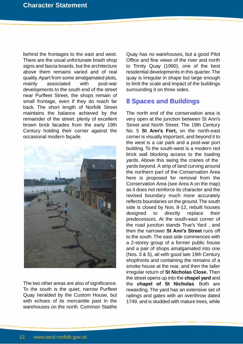
The two other areas are also of significance.To the south is the quiet, narrow PurfleetQuay heralded by the Custom House, butwith echoes of its mercantile past in thewarehouses on the north. Common Staithe
Quay has no warehouses, but a good PilotOffice and fine views of the river and northto Trinity Quay (1990), one of the bestresidential developments in this quarter.Thequay is irregular in shape but large enoughto limit the scale and impact of the buildingssurrounding it on three sides.
8 Spaces and Buildings
The north end of the conservation area isvery open at the junction between St Ann’sStreet and North Street. The 19th CenturyNo. 5 St Ann’s Fort, on the north-eastcorner is visually important, and beyond it tothe west is a car park and a post-war portbuilding. To the south-west is a modern redbrick wall blocking access to the loadingyards. Above this swing the cranes of the yards beyond. A strip of land curving aroundthe northern part of the Conservation Areahere is proposed for removal from theConservation Area (see Area A on the map)as it does not reinforce its character and therevised boundary much more accuratelyreflects boundaries on the ground.The southside is closed by Nos. 8-12, rebuilt housesdesigned to directly replace theirpredecessors. At the south-east corner ofthe road junction stands True’s Yard , andthen the narrower St Ann’s Street runs offto the south.The east side commences witha 2-storey group of a former public houseand a pair of shops amalgamated into one(Nos. 3 & 5), all with good late 19th Centuryshopfronts and containing the remains of asmoke house at the rear, and then the tallerirregular return of St Nicholas Close. Thenthe street opens up into the chapel yard andthe chapel of St Nicholas. Both arerewarding. The yard has an extensive set ofrailings and gates with an overthrow dated1749, and is studded with mature trees, while
www.west-norfolk.gov.uk12
Character Statement

the chapel itself is a majestic stone structureof the early 15th Century and earlier with aplan-form of European importance.
The view north up St Ann’s Street ispleasantly constricted by the chapel yardtrees and one opposite in the corner of thecar park to the Tudor Rose Hotel, wherebrick walls screen the cars. The wall endsat No. 20, presenting a shaped gable to thestreet, and then the recessed bulk of the 17thCentury St Ann’s House (Nos. 14-18), listedand with modern railings and a low wall ofbrick and stone marking the front boundary.To the north of it is North Hirne Court, adiscreet modern design whose 1950sfrontage to the street at Nos. 8-10 matchesthe size and scale of No. 12, a balanced late18th Century stuccoed house six bays wide.The modern building does not compromisethe lower, rendered, II* medieval hall houseat Nos. 4-6, partly due to the similar heightsof the roof ridge. Immediately there isanother medieval hall house, No. 2, and, atthe corner No. 7 St Ann’s Fort, a 16thCentury timber-framed house and shop.
The west side of Chapel Street is within thisconservation area. The view north fromNorfolk Street is narrowed by the sheer brickwalls of stores, but opens quickly into Surrey
Yard. On the north corner is a post-warbuilding, and the yard itself is a car park linedwith the backs of Norfolk Street premises tothe south.
Several young trees provide the green relief,and beyond to the west loom the brickextensions to Marks & Spencer on HighStreet. North of the Yard Chapel Streetcontinues with two 19th Century shops andflats and the 17th Century No. 25.The streetopens out again on the west, for the car parkof the Duke’s Head Hotel, improved bythree beds of trees and shrubs lining theroad, but compromised by the yellow brickpile of the 1967 hotel extension set far backfrom the street line. The Market Lanejunction is marked by the timber-framedLattice House, one of Lynn’s restorationtriumphs of the early 1980s. The largest ofthe street’s three car parks turns the cornerwith St Nicholas Street, defined by low postand rail fencing and with a few trees, but witha heavier screen of trees to the west. Thesouth side of the car park is closed by therestored and converted Fells Warehouse,originally of the early 19th Century andactually on Market Lane. Isolated at thenorth-east corner of the car park is No. 26
St Nicholas Conservation Area

St Nicholas Street, one of Lynn’s many early19th Century houses of Wisbech brownbrick.
Opposite, on the east side of Chapel Street,is the new development at No. 76, then avery good late 18th Century pair, Nos. 78 &80, the last with its north return facing thechapel yard. A small amendment has beenmade to the Conservation Area here torealign the boundary with the kerb line.
The west end of Austin Street has escapedthe post-war developments, although thelarge corner building already noted, No. 76,is a new innovative low energy buildingdesigned by Jeremy Stacey Architects,completed in 2001. It extends a considerabledistance along the road, facing an excellenthigh 18th Century brick wall. South of thewall is King’s Court, with trees, and withinthe wall are the remains of the 15th CenturyGateway to the Austin Friars precinct.Beyond this to the east the scene opens intothe enormous Austin Street car park,mitigated by the screen of low trees on thesouth, and taller ones to the north by RegisHouse. On the north side Chapel Laneleading to Pilot Street runs towards StNicholas’, the junction marked by aprominent former workshop with brickwork
in the west return dating from the 17th to the19th Centuries. Beyond that is the widefour-bay facade of the early 18th CenturyNo. 15, Austin House, recessed behind ahedged garden wall, and its later extensionat right angles, No. 15A. This is an excellentgroup of three, but further east is all 1970swith the tower blocks of Regis House andPriory House (the former redeveloped asflats), but these are outside the conservationarea.
Pilot Street is one of those residentialstreets found in major towns that escapedcontinuing postwar slum clearances in thelate 1940s and 1950s by accident rather thandesign, and, like Elm Hill in Norwich, becameinstead a valued example of the merits ofrenovation over demolition. It has everything– a major chapel dominating it, fine 18thCentury railings, a cobbled street surface, aline of houses of real quality and charm, (oneof national importance), few cars, aserpentine course giving sudden changesof view, and trees. The view north fromAustin Street is towards the Perpendicularwindows of the chapel, masked by maturetrees, with a good 17th Century brick wall onthe east and on the west two modern brickcottages, followed by the Exorcist’s House
www.west-norfolk.gov.uk14
Character Statement

facing the chapel. The Exorcist’s house isdated 1635 and has a prominent Dutch gablefacing north, one of the earliest known Dutchgables in England.The street turns east, withthe 1749 chapel yard railings on the northand the continuation of the 17th Century wallon the south (partly rebuilt in this stretch). Atthe next turn north is a series of good, mainly19th Century two-storey houses, Nos. 8-18(evens), followed by another group, Nos.22-32 (evens), becoming progressively olderuntil the II* timber-framed 15th Centuryparallel hall house is reached at Nos. 28-32.Two shopfronts in the street indicate pastcommercial activity. Of enormous value arethe mature trees in the chapel yard, and atthe north end the rather garish orange brickof the modern St Nicholas Close closes theview.
At the north end an alley cuts south-eastback into the late 20th Century and thethunder of John Kennedy Road, a productof the early 1960s.The east side of this roadis outside the conservation area, and isdominated by widely-spaced post-warindustrial units and factory premises, but theview north and south still has trees. Turningnorth to North Street is a similar prospect:1950s buildings on the north, outside theconservation area, and trees on the south,partly screening the well and variouslydesigned St Nicholas Court of 1975-7, withthe spire of St Nicholas’ rising above thembeyond the foliage screen. At the west endis True’s Yard, consisting of an early 18thCentury house fronting North Street and theformer Naval Reserve pub on St Ann’sStreet, both taken in for a museum andresearch centre in 1990-1. Behind them are
two late 18th Century fishermen’s cottages,the last representatives of hundreds to havebeen built in this fishing quarter of Lynn.
St Nicholas Street links St Ann’s Street withTuesday Market Place. Its south side ismainly a car park, with the remains of the15th Century doorway to a tenement yardwhich collapsed in 1952. On the north sidestands the group of three buildingscomprising the Tudor Rose Hotel, grade II*and which has a superb mid 15th Centurydoorway and traceried door. With the bulkof the 1960s Lovell House Tuesday MarketPlace is reached. Immediately west of LovellHouse is a yard closed to the north-west bya concrete sectional wall; this area has beenremoved from the Conservation Area as itdoes not contribute to its character. Beyondthis are the marshalling yards and transitsheds of the timber yard occupying thesouthern part of the domain of the port ofKing’s Lynn.The juxtaposition indicates howmixed this area is, and how close is theconnection between late medieval housingand international trading interests: in asentence this is the story of Lynn. To thenorth-east is a surprising density of trees,appearing from this point as thick as a wood,located at the rear of St Ann’s House.To thenorth-west is a very small area which has
St Nicholas Conservation Area

been included into the Conservation Areaas a minor amendment to fit with theboundary on the ground.
Tuesday Market Place ranks among themost splendid of all urban open squares ofEngland, as well as being one of the largest(133 x 106 metres, 145 x 115 yards at itsgreatest), and one with the most interestingand ancient history. It is an irregularquadrilateral, narrowing to the north, and thishuge open area bounded by two- andthree-storey buildings has a few immaturetrees, one fairly mature tree at thesouth-west corner, a few obtrusive lampstandards and plenty of parked cars.
Of the various buildings only three are notstatutorily listed (Nos. 22 & 25 on the southside, and Nos. 1-3 at the south-east corner),but these have strong local interest. Of theothers three are graded II*. The smartmerchants’ houses which line the squarehave all been taken over for professionaloffices, and the others are purpose-builtbanks, a hotel and a public house, and theformer Corn Exchange of 1854 in the centreof the west side. None of them is withoutinterest or fails to contribute to theoutstanding quality of this environment;instead they exhibit variations on familiar
themes. Some have red brick frontages,some brown Wisbech brick, others arestuccoed, the Corn Exchange is of stone,and one, No. 14 on the north side, has falsetimber studwork (dated c.1900) applied tothe façade. Roof lines vary in height, butnever sufficiently to create a gap, and addto the air of provincial irregularity. On thewest side four lanes run off towards the riverquays.
Page Stair Lane exits from the north-westcorner, the north side beginning withsuddenly modest single-storey early 19thCentury workshops, Nos. 17A & B. Furtherwest, outside the conservation areaboundary, is the entrance and mainwarehouse of Pattrick & Thompson’s timberyard. The whole of the north side as far asthe river is the domain of timber yards, aposition unchanged since the migration ofthe Ouse allowed reclamation of this land.
At the west end of the lane is a very good1990 development of flats, Trinity Quay,overlooking the river. The south side retainsthe large 19th Century maltings, convertedto a club, but with its kiln cone surviving atthe east end, and then the rear of BishopsLynn house at the east end. This rear wingwas rebuilt in 1975.
www.west-norfolk.gov.uk16
Character Statement

Water Lane is narrow, between No. 19 andthe Corn Exchange, and for the most partdominated by the tall brick wall of the 1996renovation and adaptation of the Exchangeon the south. On the north however is an18th Century brick wall. The lane leads to asecond large square, Common StaitheQuay, which benefits from the wideexpansive views from the south-west tonorth-west across the River Ouse.There arelimited plantings of trees and shrubs on thenorth side, much car parking but fewdetractors in the form of modern streetfurniture. The Trinity Quay development tothe north is complementary, and theenergetic, irregular, brick and renderedConservancy Board Pilot Office (1856 &1864) is a tangible reminder of the nauticalpurpose of this space, which has hardlychanged its shape for 200 years, and hasexisted for several hundred. The Pilot Officefunnels attention south to Ferry Street wherethe view is controlled by the Crown & Mitrepub, of brick and of 16th Century origins.The south side continues with low brickoutbuildings before cutting back for the yardat the rear of the Globe Hotel, with a modernextension to the hotel At this point the northside of the street has its own opening,allowing glimpses into the east side ofCommon Staithe Quay and even of TrinityQuay in the distance. The remainder of thestreet towards Tuesday Market Place andthe tree at the end has the three-storeylength of the cream-painted Globe Hotel onone side and a modern public lavatory blockon the other. Bollards hedge it in.
In the centre of the east side of the MarketPlace is Market Lane, an ancientthoroughfare linking the market with ChapelStreet. Being straight and narrow theenormous glazed-brick extension to theDuke’s Head Hotel of 1967 is not
immediately apparent, but Fell’s Warehouseopposite tries to compensate, as does thegood early 19th Century red brick wall onthe north side of the lane. Lattice House atthe junction with Chapel Street then claimsall attention. From the south-east corner ofTuesday Market Place is another narrowlane, Surrey Street, this time curving gentlyto the south at the east end. Startingbetween the side walls of two 20th Centurybanks, it is largely given over to car parking,with views of the backs of buildings onneighbouring streets. The 19th centurywarehouses and workshops on the northside have been demolished.
One of the highlights of the southern end ofthe conservation area is Purfleet Quay,visually part of the open expanse of King’sStaithe Square on the southern bank of thePurfleet. The river was culverted to the eastin the 19th Century, so that Purfleet Bridgecrosses at the half-way point, with openwater between the new (1999-2000)quaysides and caisson gate to the west andthe cut off canal to the east. The bridge hassome 17th Century brickwork, and has beenre-paved with contrasting setts in 1999 aspart of the Millennium North Sea Haven
St Nicholas Conservation Area

Project, and it stands right next to HenryBell’s celebrated Custom House of 1683,sited for maximum picturesque effect.
The Quay itself is neatly paved and has alength of anchor chain which has scenicvalue but also acts as a parking deterrent.The traditional standing figure statue ofCaptain George Vancouver, the famousnaval map-maker of the 1780s and fromLynn, is by Penny Reeve and was erectedin 2000. On the north is the return of No. 1King Street, then a lower two-bay pair ofbrown brick houses, all of which are boardedup. Next is an early 17th Century brick andstone warehouse (converted to offices), withits three-storey loading gable rising aboveits neighbours. The lower gault-brickwarehouse range of 1876 which follows isbuilt over a 16th Century warehouse, ofwhich two arches remain in the rear wall.The Quay turns north, with another
prominent and dignified brick 19th Centurywarehouse, and, at the north end, the gableof Ouse House with its low veil of shrubbery.
Any street which begins with a monumentlike the Custom House will find competitiondifficult, but King Street manages with ease.It is 212 metres (232 yards) long, south tonorth, and with a mean width of 14 metres(15 yards) was the widest street in King’sLynn from the 13th Century to 1804 whenLondon Road was created. It curves gentlyto the east to meet the south-west corner ofTuesday Market Place and almostimperceptibly undulates, but the entiredeviation in height is only 90 centimetres (35inches). Almost without exception the houseswhich line it wear Georgian dress, but thesefacades are usually additions by theirmerchant owners to modernise the visiblewhile retaining the older cores. In the later19th & 20th Centuries most of the houseswere adopted by professionals for theiroffices, as they remain today, but unlikeTuesday Market Place there is still a fewdomestic ranges in use as such. Unhappylate 20th Century ornament or loss of originalsash windows is little known here. On thewest side every building is listed, as aremany of those in the yards behind, for thesebegan life as the 15th Century warehousesof the merchants living in their halls by thestreet. There is the grade I St George’sGuildhall of 1410-30, and six grade II*merchant’s houses or warehouses.
The east side has one grade I building, butthis is Norman, with twin stone arches inside,and 14th Century additions on their ownworth a high grade. Of the other buildingsonly four are not listed (Nos. 2, 12, 22 and50), but they all contribute to the quality of
www.west-norfolk.gov.uk18
Character Statement

the street. There are only two post-warbuildings in the street, Nos. 12 (part) and 50,but these blend in quite well.
The street has the dignity that the newprofessional classes will have appreciated,but at the south end of the east side is aseries (Nos. 2-10, with No. 15 PurfleetStreet) of less pretentious housesnevertheless dating from the 16th Century(No. 4) to the early 18th Century. With theirvariations in height and width and the gentlerhythm of colourwashing, red brick andbrown brick, they are the image of anundisturbed scene from a major Englishmarket town.
On the west side of King Street are severallanes, alleys and entries to yards of privatemedieval houses, necessary for access tothe warehouses which developed betweenthe thoroughfare and the river. Thewarehouses collectively are one of the bestgroups in the country illustrating evolution ofdesign from the early 15th Century.Workingfrom south to north, the first is behind No. 3.A block of new flats on the south is followedby a red and gault-brick 19th Centurywarehouse facing the listed range behindNo.5 King Street. At the end is the
warehouse noted from Purfleet Quay, andalso the two 16th Century arches against therear wall of the Probation offices.
The yard opening through the medieval Nos.7 & 9 has four warehouses, three of whichare listed (one II*). The yard has trees andbushes and narrows to the east end whereit faces further greenery in the garden ofOuse House; like all these yards it is a quietbackwater. Trenowaths Place has a widecarriage entry under No. 11, and it is a wideyard with, on the north side, a range of 19thCentury maltings and on the south a set ofwarehouses, both groups converted tohouses and flats. At the river end is a smallraised garden and a summerhouse, all ofthe 1980s. The actual entry to the yard iscurious, for the door north of thecarriageway, apparently within the curtilageof No. 11, in fact leads to the hall entrypassage of the adjacent house.
No. 15 has an archway to a narrow yardpaved with setts and hemmed in by the listedbuildings on either side, and, to the west, bythe back of the Trenowaths Place maltings.Then follows Aickman’s Yard, famous asthe site of John Aickman’s iron foundry, asthe plaque on No. 19 records, dated 1827.The wide carriageway has a segmental arch
St Nicholas Conservation Area

and within it the doorway into No. 19. Theyard itself begins with three grade II-listedbuildings, one of them associated withfoundry work, and beyond them are twoworkshop units, that to the south dated 1891,to the north 1904. The earlier one has beenraised a storey and fitted with moderntop-hung casements, but both retain the nowrare lap-glazing to the ground-floor windows.The west end has been closed by railings ofthe 1990s to form a car park for Old SchoolHouse, with trees on either side. The 17thCentury Old School House is the nextbuilding north, with very fine railings outsideand a projecting entrance porch leading toa group of flats created in 1982 out of theschool buildings erected between 1902 andthe 1930s (it was a school from 1902-79).An L-shaped building at the west end,beyond a shrubbery bed, has an archopening to the communal garden by the riverwhich has mature trees and lawns, and isbounded by 15th Century brick walls on thenorth and south. The one to the south islisted, but the other is not and appears to bethe only remaining wall of a warehouserange edge-on to the river.
Ferry Lane, the narrowest thoroughfare inKing’s Lynn, has existed since the latemiddle ages, leading to the ferry across theOuse to West Lynn, which still operatesdaily, except for Sundays and bank holidays.Paved with flagstones it is bounded on thesouth by the utilitarian rear walling of the OldSchool Court buildings in Fletton brick, buton the north by a 19-metre (16 yard) lengthof 15th Century brick wall which is one of theoldest known examples in England of bricklaid in English garden wall bond. This givesway to three 19th Century cottages, thenfurther mixed walling, mainly 19th Century,with a plaque: H & E. J. Everard 1881,referring to the Everards & Blencowe
brewery which stood north of this point. Thebuilding at the west end is the headquartersof the Ouse Amateur Sailing Club, and theferry jetty, although of modern construction,merits attention for the antiquity andcontinuity of the site.
St George’s Yard South runs between StGeorge’s Guildhall on the north and the II*No. 27 on the south, and at once there arevaried views of medieval warehouses,slightly compromised by the single-storeypost-war building on the south side.
The series of long narrow buildings on theright dates from the 1420s at the east endto the late 15th Century by the river, and theywere all warehouses built gable-end on tothe previous one as the course of the rivermigrated west over this period. All are ofhistorical significance and are listed.Opposite are 19th Century buildingsassociated with the brewery, and at the westend a raised garden with lawns and shrubsoverlooks the river, but the 15th Centurywatergate is difficult to see. St George’sYard North is on the other side of theguildhall, and has the best and mostunrestored view of the sides of the medievalstructure with its heavy buttresses taking thethrust of the scissor-braced roof inside, which
www.west-norfolk.gov.uk20
Character Statement

has no tie beams. No. 29 on the south sideof the yard is a late 15th Century brickbuilding with a partial crown post roof. Thewest end of the yard is closed bywhite-painted 19th Century warehousing.
The east side of King Street has fewer yardsand they are less rewarding, partly becauseof 1970s redevelopment of the area behind,including a new spur to Purfleet Street actingas a service road to the High Streetpremises. This involved clearances ofmedieval yards and buildings.Working northto south the first is north of No. 50, but it isa simple entry to the rear yard of therestaurant on the corner with TuesdayMarket Place. The opening to No. 46 hasiron gates to the wide passageway, pavedwith late 19th Century setts. The concreteyard beyond opens to a late 19th Centuryhouse with a bay window and a range ofwarehouse units of the same date convertedto six flats. At the east end stands anotherwarehouse converted to flats, and beyondthat the view is closed by the renderedexpanse of the rear of a High Street block.The passage to No. 42 has been absorbedinto the offices occupying the house, andthat to No. 40 is no more than a yard entry.Between Nos. 24 & 26 is a finely gaugedelliptical brick arch over the entry, with good19th Century gates, and within the longtunnel are the original doorways into thedomestic parts of the separate premises. Afurther set of 20th Century iron gates at theeast end closes the passage from the carpark at the rear, and the turning space of thePurfleet Street extension. A converted 19thCentury warehouse block stands on thesouth of the car park, and to the north aretrees in the garden of Nos. 28-32. An equallylong and narrow passageway between Nos.16 & 18 has studwork on the north side anda post-war building east of that, but the
passage has no east exit. No. 10 has a verywide brewery yard carriageway, with an early19th Century building on the south side anda tall 1970s commercial building on thenorth. Finally there is the plain narrowpassage to the yards at the rear of No. 4,leading to the car park at the south end ofthe Purfleet Street extension.
Purfleet Street links the Custom House withHigh Street with, when looking east fromBell’s building, the distant view of the fringesof the central area redevelopment of the1970s.The north side has No. 14 of the early17th Century and then the good 1923Classical façade of Highbridge House.Beyond the new surgery is the 1970s massof Boots Department store. On the southside, backing onto the Purfleet itself, is firsta bald and rectilinear post-war Fletton brickstructure, then a former warehouse building,refurbished and re-faced in 1989 for retailuse, the south front of which takesadvantage of the open water of the Purfleet.The north extension of Purfleet Street,already noticed as an entirely modernservice road, has the advantage of permittinginspection of the backs of the King Streethouses. At once is a car park on the west
St Nicholas Conservation Area

side, devoid of trees, and the view ahead ismainly of modern additions to High Streetpremises.
High Street is a busy pedestrianisedshopping street with larger premises thanNorfolk Street for a greater proportion of itslength, attracting the major chains. It iscompletely urban in character, and thesection north of Purfleet Street runs north,bending slightly to the west to TuesdayMarket Place. On the west side (movingnorth) at first the 1970s Boots development,then the tall narrow façade of the early 20thCentury No. 90, in Edwardian Baroquedress. Then a series of three late 19thCentury frontages with pleasantly variedelevational treatments and windows. At theend stands No. 85, a 1980s replacement infour window bays, but it fits sufficiently wellas to not be at once apparent.
There are then three taller early and mid 19thCentury shops originally with accommodationon the upper floors, all listed grade II. Nextis the mid 19th Century stone front to thegrade II* early 17th Century house behind it(Nos. 81 & 81A), and, on the south, LibraryCourt. This is a narrow paved alley with afine early 20th Century iron grille over theentrance and the excellent early 18thCentury brickwork of No. 81-81A on the northside, with sashes to the workshop range atthe west end. High Street resumes up toNorfolk Street with another series of early19th Century brown brick frontages, onepainted white, of three storeys. Thecontinuation to Tuesday Market Place is ofmuch more varied buildings, in height, widthand age, but their indiscipline is characterful.
The east side of the street, north of PurfleetStreet, again begins with a 1980s rebuiltshop, but continues with Nos. 37 & 38, alllisted and all with 19th Century brick frontsconcealing older cores. The monolithic Nos.40-42, c. 1968, is set back from the streetline, on the same plane as the early 20thCentury Nos. 43-44, which has an elaboratefirst floor projecting on iron columns andfitted with three timber oriels. It is one of fewexamples of Elizabethan revival in Lynn.Twomore 20th Century shops follow, maintainingthe higher roof-line of their neighbours to thenorth, Nos. 48-51, which are tall uniformdevelopments of c. 1820, very cosmopolitan,and all listed. Nos. 52-54 are also listed andalso early 19th Century, but designed andbuilt by different firms, and so are varied intheir roof-lines. The entry to Norfolk Streethas two curved and interesting buildingsforming a spacious approach, 1920s on thesouthand mid 19th Century on the north (No.56), the latter listed.Then Nos. 57-60, Marks& Spencer, a wide clean early 1950s shopfaçade with crisp lines and positive
www.west-norfolk.gov.uk22
Character Statement

character.The street approaches the MarketSquare with two 18th/19th Century listedfronts and the stone-clad Baroque formerbank of the 1920s, converted to a restaurantin 2008.
A short section of Norfolk Street falls withinthis conservation area, from High Street toBroad Street, which is also part of thepedestrianised shopping area. Looking east,the road curves to the left, so the narrowingstreet is closed by a pair of good tall brownbrick facades in the middle distance, givingit a constricted air. The north sidecommences with No. 56A High Street,visually part of Norfolk Street, a 16th Centurytimber framed and jettied shop and house,altered in 1969. The return façade of Marks& Spencer, Nos. 144-145, is of the 1970s,No. 143 is slightly earlier. A reasonable mid19th Century plate-glass shop displaywindow remains to the listed No. 142,otherwise of the late 18th Century, then Nos.139-141 turning the bend in the road are19th Century but heavily remodelled. Theseven-bay, three-storey Nos. 137-139 are asingle development of c. 1830, followed byan older set of three buildings with varyingroof lines and elevational treatments, Nos.134-136, and the curving façade of No. 133at the corner with Chapel Street.
The south side of the street, working west,begins with a lengthy 1970s developmentcompletely ignoring historic propertydivisions, Nos. 10-14. No. 9 is a 1980srebuild on an original single plot, and then agood group of taller early 19th Century shopswith accommodation built of brown brick,Nos. 7-8. No. 6 is of the mid 18th Centurybut rebuilt in the 19th, and with an early 20thCentury shopfront. No. 5 has a similar historybut a modern shopfront, and between thetwo is an archway into the service yard atthe rear. The remainder of this side ofNorfolk Street musters a group of two early19th Century buildings of three storeys, Nos.2A-4, a narrow rebuild and then the curvingcorner building at High Street. The serviceyard opening to the south between Nos. 5 &6, White Lion Court,leads to VancouverCourt, a large car park entirely within the1970s quarter of Lynn. The view due southis terminated by the concrete and brick backof BHS on the High Street, to the west arethe backs of other High Street shops, andall around are the signs of the post-warreconstruction.
Burton’s Court is dwarfed by the BHS store,and is no more than a service bay to theshops at the south end of High Street andthe west end of New Conduit Street. Thisstreet is all modern on the south side, butthere are some attractive buildings on thenorth, and trees have been planted in themiddle of the thoroughfare, which is anotherpedestrianised street. Nos. 1-3 are all late1980s, but Nos. 5-7 have 17th Centuryorigins, visible as brickwork in thepassageway between the two. Two widerproperties, Nos. 10 & 11 are from the midand late 19th Century respectively, and after
St Nicholas Conservation Area
this is the 1960s shopping parade reachingup to Baxter’s Plain, all outside theconservation area.
9 Listed Buildings
There are 121 listed buildings in this sectionof the conservation area. The Statutory Listwas revised in 1989-90 and issued on 26July 1993, with a number of changes madesince. .There are four buildings listed Gradel, 15 listed ll* and 102 listed ll.
Listed Grade l
Guildhall of St George, King Street.Built in 1410-30 this is the largestsurviving medieval guildhall in England,of brick, with an elliptically-vaultedundercroft and a tremendous 61-trussscissor braced roof to the first-floor hall.Buttresses to north and south flanks anda large six-light east window.Nos. 28-32 (evens) King Street. Oneof the handful of Norman stone halls inEngland, dating from the late 12thCentury, with later timber-framed rearcross wings developed almost as openhalls in their own right. The façade wasaltered in the late 14th Century toprovide a timber-framed shopfront ofthat date.Custom House, Purfleet Quay. HenryBell’s masterpiece of 1683 standing ina prominent position on the quayside,and, as Sir Nikolaus Pevsner put it, ‘oneof the finest late 17th Century publicbuildings in provincial England’.Stone-built and originally with an openarcade to three sides of the ground floorfollowing Dutch practice.Chapel of St Nicholas, St. Ann’sStreet. Founded by Bishop Turbe in1146 but rebuilt in the late 14th/15th
Century as one of the most advancedand sophisticated mendicant-inspiredchapels in Europe. Revolutionaryrectangular plan without division ofchancel or nave and a spectacular southporch. 12th Century west end and towerbase. Steeple of 1869.
Listed Grade II*
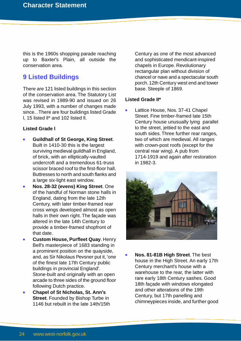
Lattice House, Nos. 37-41 ChapelStreet. Fine timber-framed late 15thCentury house unusually lying parallelto the street, jettied to the east andsouth sides. Three further rear ranges,two of which are medieval. All rangeswith crown-post roofs (except for thecentral rear wing). A pub from1714-1919 and again after restorationin 1982-3.
Nos. 81-81B High Street. The besthouse in the High Street. An early 17thCentury merchant’s house with awarehouse to the rear, the latter withrare early 18th Century sashes. Good18th façade with windows elongatedand other alterations of the 19thCentury, but 17th panelling andchimneypieces inside, and further good
www.west-norfolk.gov.uk24
Character Statement

detailing of c. 1730 for the then ownerMayor John Exton.No. 5 King Street. House of c. 1740,with a fine façade and the post-medievalplan of a passageway entrance. Goodinternal detailing of staircases, panellingand plasterwork.Nos. 7 & 9 King Street. Typical highquality early 19th Century brick façadeconcealing a 14th Century brick-builthall house on the L-plan. Excellent 14thCentury internal mouldings, and fittingsfrom this and later centuries.Remarkably early for extensive use ofbrick and stone.Office behind Nos. 7-9 King Street. A15th Century merchant’s warehouse togo with the main house, now converted.Built of brick. Depressed warehouseopenings and windows evident.No. 15 King Street. Early 16th Centurybrick hall house with the hall to the rearfollowing the L-plan arrangement, withits six-light dais window. Floored in the17th Century and with fittings of the timeof the mid 18th Century brick façade toKing Street.No. 15A(now re-integrated withNo.13) King Street. Facing the lastacross the narrow yard, also early 16thCentury, but remodelled in the early18th Century with a splendidcantilevered staircase hall with carvedtread-ends and a plaster chandelierrose.No. 27 King Street. Fine stone five-bayfront of 1739, with a Corinthiandoorcase and an addition of 1814 overthe present carriage arch. Excellentstaircase hall of the same date withfree-standing Corinthian columns. Rearwing c. 1695 for a Dutch merchant fittedwith some of the oldest sash windows
in England, with clean cut brickvoussoirs.Nos. 30 & 32 Pilot Street. 15th Centurytimber-framed hall house parallel to thestreet, jettied to front and back andformed of two ranges with a centralentrance. Crown post roof.2A-C St Ann’s Street. C. 1400timber-framed hall house parallel to thestreet, jettied both sides. Façade withtwo large arched braces and rebates fora shop window visible inside. Mullionedwindows.
Nos. 4 & 6 St Ann’s Street. Theearliest parallel hall-house in Lynn, 13thCentury, and built of rubblestone nottimber. Blocked 13th Century doorwayat the back. Scissor-braced andcrown-post roofs. Rather an uninspiringlate 1960s shopfront.Tudor Rose Hotel, 10 and 11 StNicholas Street. Mid 15th Centurytimber framed house to the west with aremarkable stone doorway arch and aPerpendicular traceried door. Hall-housearrangement of the interior intact, withthe service doorways. Crown post roof.Unusual internal gallery connects withthe 1645 addition to the east.
St Nicholas Conservation Area

Duke’s Head Hotel,Tuesday MarketPlace. Built in 1683-5 for Sir JohnTurner as an inn. Nine bays surmountedby a double Baroque pediment. Internalarrangements of a courtyard withgalleries identifiable to one range. Late17th Century staircase.Nos. 15 & 16 Tuesday Market Place.Early 16th Century range of housesfacing south down the Market Place,brought together behind the finenine-bay façade of c. 1720. Excellentdetailing of exterior and the staircase.Six-light mullioned window at the rearinto an open hall.No. 18 Tuesday Market Place.Headquarters of the Bagge family ofmerchants. The south part rebuilt in1725, the north part in 1803-4 with ahandsome bow window. Fine interiorsof 1725-30, and under the north part thelate 14th Century brick vaulted cellar ofthe medieval merchant’s premises, oneof the first to be built on the west sideof the Market Place.
Listed Grade ll
There are too many grade II listed buildingsin the conservation area to describeindividually, but they embrace a great rangeof dates from the late 14th Century to thelate 19th Century, reflecting house types andmaterials appropriate to their period. Houses,warehouses, offices, port buildings, civicbuildings and halls, banks, shops, railings,watergates, foundry buildings, bollards,quaysides, inns and bridges are all buildingtypes represented. Few towns can boast asimilar combination in such a small area,testifying to the diverse economy and tradingpatterns of a major medieval port.
Aickman’s Yard. 1, 3 & 4, Wall 12metres E of river bank
Austin Street. 15 (Austin House), 15A,North gateway to Friary precinctChapel Lane. 8 The Exorcist’s House,Cannon bollard immediately SE of No.8Chapel Street. 25Ferry Street. Crown & Mitre P.H.High Street. 37, 38 & 39, 48-51, 52, 53&53A, 54, 56, 56A, 61 & 62, 65, 82, 83& 84King Street. 1, 3, 3A, 4, 6, DentalSurgery 22m WSW of Nos. 7 & 9,Health Centre 29m W of Nos. 7 & 9, 8Chancery House, 10, Cannon Bollardat SE corner of Carriage arch under No.10, Cannon Bollard at SW corner ofCarriage arch under No. 10, 11, 13A,14 & 14A, 16 & 18, 17 Wood House, 19,20, 21 Old School Court, Railings toforecourt of 21, 23 & 25, 24 & 26, TheWhite Barn, 29 Shakespeare House, 31The Globe Hotel, 34, 36, 40 & 42, 46,48, Cannon Bollard at junction of FerryLane, The Red Barn, King’s LynnCentre for the Arts & Players RehearsalRooms, Riverside Rooms Restaurantincl Watergate, Purfleet Bridge
Market Lane. 1-8 consecutiveNorfolk Street. 5,6,142North Street. North Gate
www.west-norfolk.gov.uk26
Character Statement

Pilot Street. 22 & 24, 26, 28, Railings& Gates to S & E of St Nicholas’Churchyard,Purfleet Quay. Offices of ProbationServicePurfleet Street. 14 & 15St Ann’s Fort. 7, Watergate of St Ann’sFortSt Ann’s Street. 12, 14, 16 & 18, Gates& railings to E of St Nicholas’Churchyard, Table Tomb 3m S of Sporch of Chapel of St Nicholas.St Nicholas Street. 17, 26, Ruins ofDoorway south side.Tuesday Market Place. 4 Nat WestBank, House at rear of 4, 7 Mayden’sHead Hotel, 8, 10, 11 & 12, 14 & 14A,17 & 17A, 19, 20 Corn Exchange, 21Barclays Bank, Cannon Bollard to rearof No. 21, 23 Bank Chambers, 24, 27 &28, 29.
10 Important Unlisted Buildings
The St Nicholas conservation area is unlikemost in England in that its character is notprimarily vested in the nature of its unlistedbuildings, because of the very highproportion of listed ones. There are 121listed buildings, 69 unlisted buildings ofpositive and definable character, 48 datingwholly to the post-war period (singledevelopments such as St Nicholas Close arecounted as one) and about 65 otherbuildings. Two of the post-war buildings areso well composed that they themselves mayalso be classed as important unlistedbuildings (Marks & Spencer at Nos. 57-60High Street and No. 50 King Street) becauseof the continuity they provide in the streetscene and the support they giveneighbouring listed structures.
11 Post-War Development
The greatest concentration of post-warbuildings in this section of the conservationarea, and the most insensitive, is associatedwith the streets on the very fringe of the1960s central redevelopment - that part ofHigh Street between Purfleet Street andNorfolk Street; the south side of NorfolkStreet at the corner with Broad Street; andthe service buildings and extensions on bothsides of Purfleet Street North.The last street,developed as no more than a service road,was the most destructive of existing yards,houses and former maltings, but has themerit of not impinging on the King Street orHigh Street
elevations. The largest new blocks belongto the big commercial chains, amalgamatingtwo or more former plots, such as the Marks
St Nicholas Conservation Area

and Spencer extension on Norfolk Street,and BHS and Boots on the High Street. No.14 Norfolk Street, jutting out over thepavement, is perhaps the most arrogantlydismissive of the existing street line andbuilding character of all the late 1960s works.
Earlier and later buildings are generallybetter. The Marks and Spencer façadetowards High Street of the early 1950s hasalready been mentioned. However, also ofthat time is Lovell House, St Nicholas Street,affecting the view north-east out of TuesdayMarket Place. It lacks style and conviction,overlooking a square in which every otherbuilding exhibits those qualities. The 1975Social Security offices in Page Stair Laneare dull but tucked away behind a II* house,unfortunately involving the demolition of a16th Century warehouse. (Here there is aphotograph in the original document of theport buildings which have been demolished.)Far superior are the developments of thelate 1980s and 1990s, with the emphasisshifted to residential use, eg North HirneCourt, St Ann’s Street; and Trinity Quay ona very important site at the north end ofCommon Staithe Quay.
12 Traditional Materials
In common with the rest of King’s Lynn thematerials used are as eclectic as might beexpected in a sea-port with extensiveEuropean trading interests. In a low-lyingtreeless area of the country almost all timberwas imported either up-river from the inlandcounties or from the Baltic. English oak isconfined to the structure of timber-framedhall houses of the 16th Century and earlier,and by the 17th Century, when timberframing ceased to be used on any scale,brick was the substitute. The local brick isred, but there is a great deal of brown brick
from the yards around Wisbech, whichbecame very fashionable between c. 1780and c. 1840. For these houses the roofstructure was of Baltic fir, enormousquantities of which were imported to thetimber wharves around Common StaitheQuay, as it is today.
Colourwashing of facades, or the applicationof stucco in the 18th & 19th Centuries isfavoured in some of the more prestigiousbuildings, especially in Tuesday MarketPlace, and there are very pleasingsequences of houses with gently varyingcoloured schemes. Slate for roofs is certainlycommon, arriving in bulk from Wales afterthe railway opened in 1844, and its presenceon roofs of older buildings generally indicatesrepair or rebuilding. Otherwise pantiles onbuildings later than c. 1720 (imported fromHolland, but then made locally) and plaintileson earlier structures are the rule.
Much earlier buildings used stone as theprincipal building material, imported fromNorthamptonshire and Lincolnshire, such asin the Norman house at Nos. 28-32 KingStreet, or in the façade of No. 13, but brickis the material of the town.This area has twoexamples of large-scale use of brick as earlyas the 14th Century, at Nos. 7-9 King Streetand in the undercroft of No. 18 TuesdayMarket Place.
13 Archaeological Interest
The remains of the fort walls and of St Ann’sWatergate is the only Scheduled AncientMonument in this area (monument No. 306),but there is a great deal of evidence of lostbuildings. Hearths, walls and pits werediscovered under the Marks & Spencerextension of 1965 in Surrey Street, and ahall house at 77a High Street, while a coinhoard of late 13th Century material was
www.west-norfolk.gov.uk28
Character Statement

excavated from the Boots site in the HighStreet. On the same site is evidence of avaulted undercroft destroyed in 1865.
14 Detractors
The special character of conservation areascan easily be eroded by seemingly minoralterations such as unsuitable replacementwindows and doors, inappropriate materialsor unsympathetic paintwork and the removalof walls, railings and trees. In apredominately retail and commercial centrereplacement of shop display windows is aparticular problem, especially as thealteration is seldom necessary for structuralreasons, but for fashion and corporateidentity, so that main shopping streets, ashas long been lamented, eventually all looklike each other. Norfolk Street in particularhas so much depth of tradition, however, thatthis is still resisted. High Street is morevulnerable, and there is more disunity offascia boards and design of display windows,and a complete lack of any shopfronts earlierthan 1950. The good Marks & Spencerfaçade has lost its first floor Crittall windowsin favour of uPVC, and there are a numberof other first- and second-floor elevationswith altered fenestration. Other examples ofinappropriate windows are rare, of which themost notable are at No. 5 St Ann’s Street.
Traffic signs are a slight problem, particularlythose signs referring to a pedestrianisedzone (at the junction between High Streetand Tuesday Market Place, and in PurfleetStreet), no-entry signs (at the south-westcorner of Tuesday Market Place) and
pay-and display car park machines (KingStreet). In front of the Pilot Office in CommonStaithe Quay is a camera surveillance pylon,
There are unattractive corrugated iron roofsto the former garages on the south side ofFerry Street.
These are virtually all the detractors in theentire area, and such is the overwhelmingquality of the remainder that enumeratingthem is in the first place possible, and in thesecond place slightly ungracious.
St Nicholas Conservation Area

Appendix 1
www.west-norfolk.gov.uk30
Character Statement


Conservation Objectives
The overall conservation objective isto protect and reinforce theestablished special character ofConservation Areas and their setting.
This will be achieved by:
Encouraging the retention andmaintenance of buildings whichcontribute to the overall characterof each conservation areaEnsuring that new development issympathetic to the special qualitiesand character of each conservationareaProtecting the setting of theconservation area fromdevelopment which adverselyaffects views into or out of the areaThe retention, maintenance andlocally appropriate new planting oftreesMaintaining and enhancing localfeatures and details whichcontribute towards an area's localdistinctivenessWorking with the community toprepare schemes of enhancementEncouraging the removal ofdetractors to the special characterof each conservation area
www.west-norfolk.gov.uk32
Character Statement

Contacts and advice
Within conservation areas, a number of special controls apply and it is advisable that anyone proposing to carry out new development, alteration, extensions, installations or demolition should seek advice from Development Services at an early stage. Special controls also apply to the trees sand some may be subject to Tree Preservation Orders. Anyone wishing to carry out work to trees within a Conservation Area should therefore seek advice from Development Services.
King’s CourtChapel StreetKing’s LynnNorfolk PE30 1EXTel: (01553) 692722Fax: (01553) 691663DX 57825 KING’S LYNN
830/172/01

River G
reat Ouse
Saturday MarketPlace
Tuesday MarketPlace
South Quay
PurFleet
Siteof
Common StaitheQuay
AlexandriaDock
Transit Sheds
Timber
Yard
Priory
CarPark
Burton's
PurfleetQuay
Mud
Roof CarPark
Court
Garage
Regis
Cinema
Town Hall
Crowns
College
Chapel
Duggie
Jubilee
Guildhall
OuseHouse
Fells Warehouse
SailingClub
St Nicholas Close
TudorRose
Museum
Eagle
BankHouse
StJames
St NicholasChapel
LovellHouse
Burkitt Hom
es
Duke's HeadHotel
King'sCourt
Globe
TheGranaries
Centre
Magistrates'
GlobeHotel
Tower Street
PrioryHouse
Guildhall of Saint George
New Conduit Street
Head PostO
ffice
High Street
The
CornExchange
Crown andMitre
Broad Street
St Margaret'sChurch
PUR
FLEET
Surrey
Yard
StMargaret's
OLDSUN
CLO
UG
H LAN
E
Ct
GranaryCourt
PURFLEET STREET
NORTH STREET
PURFLEET PLACE
CH
APEL STREET
SOUTH CLOUGH LANE
CH
APEL LANE
ALBERT
AVENU
E
SURREY STREET
UNION LANE
REGENT PLACE
TRENOWATH PLACE
JOH
N KEN
NED
Y RO
AD
CENTRAL ROAD
SEDGEFORD LANE
NORFOLK STREET
LAN
SDO
WN
E ST
REE
T
HIG
H S
TREE
TWATER LANE ALBER
T STREET
FERRY STREET
STAN
N'S
STR
EET
ST NICHOLAS STREET
KIN
G S
TREE
T
SQUARE
PILO
T ST
REE
T
GEO
RGE
YARD
REGENT WAY
PARADISE PARADE
BLACKFRIARS STREET
PARAD
ISE LANE
GR
ANAR
Y C
OU
RT
BAXTERSCOU
RT
AUSTIN STREET
BOUN
DARY
ROAD
WES
T
BAKER LANE
HEXTABLE ROAD
PAGE STAIR LANE
TrinityQuay
ST JAMESCOU
RT
BOUNDARY ROAD EAST
MARKET STREET
AUSTIN S
T
ST JAMES STREET
MARKE
TLANE
ST JAMES' STREET
111
Offices
Youth
Gateway
St Anne'sfort
114
118
11a
Town
Wal
l
Vicarage
Baxter's
29c
19c
99c
(Austin Friars)
Swing-bridge
founded
1100)
Tanks
True's
8 to 11
Ward Bdy
11 to 12
11 to 37
Library CourtRoof
Lock
Nor
th E
ndYa
rd
Ferry F
Ferry
Terminal
Bollards
56
Posts
Bols
20
61
26
53
3 to 5
30
12
33 to 39
19
15
84
10
LandingSteps
36
29
50
1 to61
21
32
28
25
3942
31
1 to
7
38 to
54
34
12 to 34
45 to
51
38 to
44
21 to 22
17b
1 to 23
7 to
103a
57 to
27
30 to 38
5a
143
47
17 to 29
18a
101
23a2a
2 to
97b
10 to
16
99
3a
139
100
55
136
17a
20a
15a
77d
127
109
22b
102
Multistorey
Bus Station
Mean H
igh & Mean Low
Water
Shelter
LandingStage
Travelling Crane
Sta
Sluice
TelEx
Crane
Old School Court
St Dominic's Square
LB
ED &
Ward Bdy
MLW
AICKMAN'S YARD
44a
to 4
4m
North HirneCourt
Mean H
ighW
ater
Bank
Shelter
16
2
78
9
5
17
74
28
86
49
Timber
Yard
Sluice
2
1
14
Bollards
4
Garage
Bollards
41
26
5
22
13
10
2
3113
3
Def
15
5
27
42
1
Mud
8
3
41
Shelter
38
23
MLW
Sluice
3
114
5
CarPark
1
15
27
22
3
56
20
7
1
9
Tanks
CarPark
9
112
22
37
21
2
21
23
25
STAN
N'S
STR
EET
18
10
20
27
3
52
9
16
Bollards
14
1
76
17
SubSta
9
23
1
House
41
14
MLW
7
12
15
115
Mean H
ighW
ater
6
1
39
33 to 39
BOUNDARY ROAD EAST
15
29
23
40
29
6
13
15
1
21
14
23
Travelling Crane
42
3
80
Mud
10
25
19
25
17
MLW
Bank
1
1
6
Mud
3
25
16
14
22
to
SubSta
Mud
38
7 8
26Sluice
106
25
Bollards
11
6
12
3
16
40
7
Shelter
19
South Quay
90Timbe
rYard
1218
11
17
LB
River G
reat Ouse
Mud
23
8
1
22
44
21
29
15
23
5
Def
11
24
6
35
22
Mean High Water
Hig
h St
reet
7
4
26
46
47
18 10
20
16
34
4
5
OLDSUNWAY
15
1
22
Broad Street
4
121
JOHN KENNED
Head PostO
ffice
39
6
LB
Bollards
SubSta
8
11
24
4
SubSta
Mud
21
14
133
14
19
1 5
BLACKFRIARS STREE
1
Bank
Bols
21
3
45
35
25
LB
5
12
23
19
21
18
78
War
d Bd
y
11
CLOUGH LANE
34
1
Bollards
11
18
29
28
SubSta
33
6
1
8
3
HEX
7
CarPark
2
1
to
3
BAKER LANE
29
32
River G
reat Ouse
5
Tanks
2
7
63
2
5
8
24
55
1
9
14
1
21Posts
40
7
1
2
6
Mean H
ighW
ater
73
38
JOHN KENNEDY RO
AD
REGEN
9
23
Works
36
21
1
5
8
23
12
Mud
37
40
4
8
36
Mud
3
LB
69
2422
3
15
2
24
19
50
3
20
39
1
Bank
Bollards
7
1
7
ED &
Ward Bdy
19
14
1
1
31
1
16
4
2
41
113
46
KING’S LYNNCONSERVATION AREA
ST MARGARET’S AREA
KING’S LYNNCONSERVATION AREA
NORFOLK STREET
KING’S LYNNCONSERVATION AREA
ST NICHOLAS AREA
This Map is reproduced from Ordnance Survey material with the permission of Ordnance Survey on behalf of the Controllerof Her Majesty’s Stationery Office © Crown Copyright. Unauthorised reproduction infringes Crown Copyright and may leadto prosecution or civil proceedings. Borough Council of King’s Lynn and West Norfolk. Licence No.100024314. March 2010.
NOTATION
LISTED BUILDINGS
IMPORTANT UNLISTED BUILDINGS
CONSERVATION AREA BOUNDARY
DIVIDING BOUNDARY
N
Notation:DESIGNATED - 1969EXTENSION - 15.05.79EXTENSION - 09.10.91REVISED - 06.02.92REVISED - 05.09.03