spokane central city transit alternatives analysis … central city transit alternatives analysis...
TRANSCRIPT

Spokane Central City Transit Alternatives Analysis Summary Report i


Spokane Central City Transit Alternatives Analysis Summary Report i
Table of Contents
1. Introduction ................................................................................................................ 1
2. Description of the Project ............................................................................................ 3
Project Study Area ....................................................................................................... 3
History and Context ..................................................................................................... 4
Activity Areas ............................................................................................................... 4
Purpose and Need Statement ....................................................................................... 6
Project Objectives ........................................................................................................ 9
Travel Market Assessment ............................................................................................ 9
3. Identification and Screening of Alternatives ............................................................. 11
Screening Questions ................................................................................................... 13
Corridors Considered ................................................................................................. 13
Corridor Screening Results ......................................................................................... 26
Modes Considered ..................................................................................................... 29
Mode Screening Results ............................................................................................. 31
4. Evaluation of Alternatives ......................................................................................... 35
Summary of Results ................................................................................................... 37
Detailed Corridor Evaluation ....................................................................................... 38
Detailed Mode Evaluation .......................................................................................... 42
5. The Locally Preferred Alternative .............................................................................. 51
Corridor ..................................................................................................................... 51
6. Summary of Public Involvement Activities ................................................................ 55
Project Committees.................................................................................................... 55
Public Open Houses ................................................................................................... 62
Web Site .................................................................................................................... 65
Targeted Outreach Events/Business Community Events ............................................. 65
Title VI Outreach ........................................................................................................ 66
7. Funding ..................................................................................................................... 67

ii Spokane Central City Transit Alternatives Analysis Summary Report
Tables 3‐1 Results of Alternative Screening Process .................................................................... 27
3‐2 Results of Initial Mode Screening ............................................................................... 31
4‐1 Evaluation Framework ............................................................................................... 35
4‐2 Detailed Corridor Analysis Summary .......................................................................... 41
4‐3 Attributes of Electric Trolley Bus and Streetcar .......................................................... 47
4‐4 Relationship of Mode Characteristics to Project Objectives ....................................... 49
6‐1 Core Stakeholder Group Roster ................................................................................. 58
6‐2 Technical Advisory Group Roster ............................................................................... 59
6‐3 Sounding Board Roster .............................................................................................. 61
Figures 2‐1 Study Area Boundary and Activity Areas ...................................................................... 3
3‐1 Screening and Evaluation Process .............................................................................. 12
3‐2 A “Thumbnail” Comparison of the Modes Considered ............................................... 30
4‐1 Short‐listed Corridors ................................................................................................ 37
5‐1 LPA Alignment ........................................................................................................... 53
6‐1 Project Timeline ........................................................................................................ 56
6‐2 Project Committee Structure ..................................................................................... 57
Appendices A Detailed Corridor Evaluation Matrix B Summary of Stakeholder Preference Survey Results C Resolutions Adopting the Locally Preferred Alternative

Spokane Central City Transit Alternatives Analysis Summary Report 1
Downtown Spokane at S. Lincoln Street and W. Sprague Avenue
1. Introduction
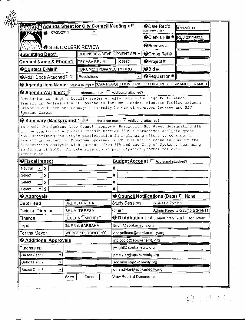
This report documents the process by which the Spokane Transit Authority (STA), the City of Spokane and their partners evaluated options for and selected the Spokane Central City Transit Project’s Locally Preferred Alternative (LPA) following the Alternatives Analysis (AA) process prescribed by the Federal Transit Administration (FTA). The LPA – unanimously adopted by the STA Board of Directors and the Spokane City Council in 2011 – is a Modern Electric Trolley (MET) that connects historic Browne’s Addition and Gonzaga University via downtown Spokane.
The purpose of this AA effort was to define a High Performance Transit corridor1 that will:
Serve Central City Spokane and increase transit ridership to, from, and among existing and emerging activity areas in the downtown core;
Help stimulate development in downtown Spokane in a manner that supports local and regional land‐use goals, objectives, and plans; and
Maximize regional support of and investment in the transportation system, while being environmentally sensitive and garnering broad public support.
The selected corridor was 1 of 11 potential corridors that connected various residential, employment, medical, and commercial activity centers in the Central City. The selected mode was 1 of 8 modes considered by the project, ranging from streetcar to light rail transit to aerial tram. Chapter 2 of this report describes the purpose and need for the project, the overall project objectives, and a travel market assessment. Chapter 3 reports the universe of alternatives that were considered and how they were screened against the project’s purpose and need. Chapter 4 details the evaluation process used to narrow these corridors and modes to the LPA, Chapter 5 provides detail on the LPA’s corridor and mode. Chapter 6 provides a summary of public involvement activities, including committees, open houses, and the project website. Chapter 7 highlights funding considerations to be assessed in future project.
The following section discusses the history and context of the project and provides an overview of the process and timeline for the AA.
1 This effort defines High Performance Transit as frequent, reliable, all-day mass transit service.

2 Spokane Central City Transit Alternatives Analysis Summary Report
This page left blank intentionally.

Spokane Central City Transit Alternatives Analysis Summary Report 3
2. Description of the Project
This section describes the project study area and the activity areas identified as having high levels of housing, employment, and/or service activities. It also provides the project purpose and need statement and the project objectives.
Project Study Area Figure 2‐1 shows the project study area and activity areas within its boundary. The study area is approximately 2 miles wide (north to south) by 3 miles long (east to west); and encompasses the core of downtown Spokane and several of the region’s primary trip producers and attractors. This area is generally bounded by Mission Avenue to the north, Perry Street to the east, 14th Avenue to the south, and the Spokane River to the west. It is bisected by Interstate 90 (I‐90), railroad tracks owned by Union Pacific Railroad and used by freight trains and Amtrak, and the Spokane River. The study area was agreed upon by the Core Stakeholders early in the process.
Figure 2-1 Study Area Boundary and Activity Areas

4 Spokane Central City Transit Alternatives Analysis Summary Report
Spokane Streetcar Feasibility Study
Fast Forward Spokane: Downtown Plan Update
Connect Spokane
History and Context
Previous Studies Multiple plans and studies over the past 20 years have identified transit investments that would improve mobility, increase accessibility, and support land‐use decisions for the Central City. Over the past decade, as transit ridership has burgeoned and reinvestments in the greater downtown area have grown, so too has the interest and desire to move forward with capital and operational transit investments.
The Spokane Streetcar Feasibility Study, completed in 2006 for the Spokane Transit Authority, Spokane Regional Transportation Council (SRTC), and Downtown Spokane Partnership, provided a purpose and context for a streetcar system in downtown Spokane. It also provided information on representative vehicle types, discussed alignment alternatives, and provided conceptual design and station locations for an initial segment of an alignment that would connect the County Campus area (northwest quadrant of the Central City area, north of the Monroe Street bridge) with the Riverpoint campus (southeast quadrant of the Central City, east of Division Street).
The 2008 Fast Forward Spokane: Downtown Plan Update references the Spokane Streetcar Feasibility Study and confirms the need for greater transit service in Spokane’s central city. It notes that multimodal transportation is a key part of the vision the community has put forward for the downtown area. This plan was adopted by the City of Spokane City Council as a subarea plan to the City’s Comprehensive Plan.
The Spokane Transit Authority’s Connect Spokane: A Comprehensive Plan for Public Transportation, adopted in 2010, establishes the framework for Spokane’s High‐Performance Transit (HPT) Network. The HPT Netword is envisioned to incorporate multiple high demand travel corridors with premium, frequent, all‐day transit service to activity centers throughout the region, including the Central City.

Spokane Central City Transit Alternatives Analysis Summary Report 5
Spokane County Courthouse
Gonzaga University
Activity Areas Important activity areas in the Central City that could benefit from High Performance Transit service are illustrated in Figure 2‐1. Not to be confused with “Centers and Corridors,” a formally adopted strategy in the City’s Comprehensive Plan, these 13 neighborhood and/or business activity areas were identified in the AA as places of intensive human activity in the downtown area, existing and envisioned in the future. The primary use within each activity area ranges from predominantly residential to primarily commercial, with some of the areas exhibiting a mix of jobs and housing. Following is a brief description of each activity area.
Kendall Yards Residential: identified in plans as a major future residential area. It is located to the north of the river, on the western edge of the study area.
Kendall Yards Commercial: a commercial area north of the river and west of Monroe Street. It is expected to incorporate a mix of uses, including hotels, offices, and retail. This activity area was considered distinct from the Kendall Yards Residential activity area because it is expected that the two areas will be developed at different times.
County Campus: Spokane County government offices and the Public Safety Building are at or within two to three blocks of the Courthouse on Broadway Avenue, a few blocks west of Monroe Street. The area is defined broadly to also include the commercial activity along Monroe Street from Boone Avenue to Bridge Avenue and spans to the north and east to include the Spokane Veterans Memorial Arena.
North Bank: A mixed used area north of the Spokane River between Monroe and Division streets. It currently includes a mix of commercial, hospitality, and cultural facilities. Plans developed over the past several decades call for further intensification of this area.
University District: includes both Gonzaga University and Riverpoint campus (which hosts academic services for Washington State University, Eastern Washington University, Whitworth University, and Community Colleges of Spokane) and spans the areas to the north and south of the river. While the campuses provide the primary loci of activity, there are residential areas around the Gonzaga campus. This area also includes the Hamilton Street commercial area.
South University District: currently a light industrial/commercial area that includes 2nd and 3rd Avenues and has been designated as the southern portion of the University District. Residential and biomedical services uses are expected to grow in this area as the University District expands south.
East Downtown: an area with a mix of retail and housing to the east of the Downtown Core that also includes the Intermodal Facility (intercity bus and Amtrak).
Downtown Core: a regional center that includes the Central Business District, government buildings, Retail District, Financial District, and Davenport Arts District. The core has always been the central location for mass transit, with stations generally located between Howard and Monroe Streets and

6 Spokane Central City Transit Alternatives Analysis Summary Report
Browne’s Addition neighborhood
Source: www.spokanephotos.com
adjoining Main or Riverside Avenues. Today, Spokane Transit Authority’s Downtown Plaza transit center is located on Sprague and Riverside avenues between Post and Wall streets.
West Downtown: a mixed‐use area immediately to the west of the Downtown Core.
West Central: a mixed‐use residential and commercial area north of the Kendall Yards Commercial area.
Browne’s Addition: a residential neighborhood at the western edge of the study area and one of the oldest neighborhoods in the city. Originally developed with expansive mansions built by Spokane’s elite, residential density intensified during the early 20th century and particularly through World War II, as significant levels of transit service connected the neighborhood to downtown and destinations to the west, including military installations. Today, the density in Browne’s Addition remains higher than most Spokane neighborhoods. The neighborhood has become a destination for seekers of recreation opportunities and restaurants.
Cannon’s Addition: a relatively dense residential area in the southwest corner of the study area.
Medical District: located south of I‐90. It incorporates mostly service‐oriented uses, including the Deaconess and Shriners Hospitals, Lewis and Clark High School, Providence Sacred Heart Medical Center, Rockwood Clinic, and the 5th and Browne Medical Center. There are pockets of multifamily residential buildings included in this center (Central Lower South Hill neighborhood).
Purpose and Need Statement The project team and Technical Advisory Group developed the project purpose and need statement. This statement was reviewed by both the Core Stakeholder Group, the Sounding Board, and the general public. It was ultimately approved by the Core Stakeholder Group at a meeting on September 1, 2010, and is as follows:
The Purpose of the Central City Transit AA Project is to: increase transit ridership to, from, and between existing and emerging activity areas within the Spokane downtown area, including the Downtown core, the University District, and the Medical District; directly connect residential areas with major employment centers; help stimulate development in downtown Spokane that is in support of local and regional land use goals, objectives and plans; and maximize regional support of and investment in the transportation system; while being environmentally sensitive and garnering broad public support.
The Need for this project arises from the opportunity to focus infrastructure investments within the City of Spokane’s Targeted Area Development (TAD) districts that are within the Central City , in order to encourage development in the downtown area. Many corridors and markets within the study area have potential for new development but lack amenities, including transit service, which

Spokane Central City Transit Alternatives Analysis Summary Report 7
would stimulate development. In 2009, the retail opportunity gap2 within the City of Spokane was about $816.7 million. Planning and economic development policy within the City of Spokane has identified key districts for revitalization. The City’s Comprehensive Plan identified Centers and Corridors for infill development and city staff have developed TAD districts as an economic development tool. One goal of the Centers and Corridors strategy is to work with the community to revitalize the pedestrian‐oriented commercial districts in Spokane while strengthening and diversifying Spokane’s economy. The goal of the TAD approach is to maximize capital investment by aligning infrastructure development with economic opportunity. Spokane’s Comprehensive Plan identifies the downtown area as the Regional Center, containing the highest density and intensity of land use. Three of six TADs within the city are located in the study area: two within the University District and one within North Bank. Two of the three TADs within the study area are tax increment finance districts, providing the opportunity for funding for public infrastructure as redevelopment occurs.
The opportunity to improve transit accessibility, efficiency, and competitiveness for trips within the downtown core. The public transportation system in Spokane is currently designed as a hub‐and‐spoke system, with most routes in the study area converging on the downtown Plaza. While this design provides a high level of transit accessibility in the heart of downtown, connections to other activity nodes within the downtown core often require a transfer. The lack of direct service and inconvenience of transfers adversely impacts the competitiveness of transit for shorter journeys within the downtown core. For example, there currently is no direct connection between the WSU Spokane campus in the University District and Deaconess Hospital in the Medical District; travelers must transfer at the Downtown Plaza to make that connection with a convenient transfer (less than 10 minutes wait time) feasible only once an hour.
The opportunity to increase regional transit accessibility of downtown activity and employment centers. Downtown activity nodes like the Medical District attract trips from across the region. However, the existing hub‐and‐spoke transit network provides significantly less regional accessibility for activity nodes that are not within walking distance of the Plaza. Destinations within walking distance of the Spokane Transit Authority Plaza (see photo to right) have a significantly higher transit mode share than those that are not within walking distance. This is in spite of the fact that activity nodes like the University and Medical Districts have other transit supportive factors such as constrained/paid parking and employer‐sponsored
2 The retail opportunity gap is the difference between the 2009 demand (consumer expenditures) and the supply (retail sales). This gap includes all retail sales, including eating and drinking places.
Spokane Transit Authority Plaza Location

8 Spokane Central City Transit Alternatives Analysis Summary Report
Commute Trip Reduction (CTR) or other transportation demand management programs. Through improved transit accessibility of these activity centers to the regional transit system, more travelers will elect to use transit for commuting and other trip purposes.
The demand for convenient downtown transit service outside of peak periods. As a 24‐hour live, work, and play destination, downtown Spokane has considerably more transit demand in off‐peak periods than the region as a whole. However, the infrequent nature of regional ‘hub and spoke’ services outside of the peak periods underserves the demand for non‐commute trips within downtown. For example, during weekday and Saturday evenings, service is only provided every 30‐60 minutes between Gonzaga University and the Plaza, with service ending at 9 PM on Saturdays. While a trip from Gonzaga University to the Medical District takes only 16 minutes during peak hours, on weekday evenings this trip can take as long as 50 to 60 minutes. Transit trip times such as these are too long to attract non‐commute riders during off‐peak hours.
The need to overcome existing barriers to pedestrian mobility. Interstate 90, the Union Pacific and Burlington Northern Santa Fe Railroads, and the Spokane River are physical barriers to pedestrian movements in downtown Spokane. These barriers subdivide the downtown area into multiple districts that are challenging or uncomfortable for pedestrians to travel between. Transit can extend the range of the pedestrian by overcoming these barriers and providing practical, comfortable, non‐automotive travel options among downtown activity nodes.
The challenges that new riders encounter in understanding the existing transit system. Downtown Spokane is a regional activity center that attracts residents and visitors from across eastern Washington and beyond for services, special events, shopping, and entertainment. The current bus system serves the larger Spokane area beyond the downtown area and can be intimidating and prohibitively complicated to new transit users who may also be unfamiliar with the layout of the city. A system is needed that provides comprehensible transit service in the downtown area to meet the travel needs of new and infrequent users.
The projected future traffic congestion in the downtown core. Congestion and circulation issues are projected to worsen with further population and employment growth and continued economic development in the Spokane area. Since 1999, the vehicle miles traveled per day have doubled in the area and residential homes currently generate more than 10 person trips per day (Source: 2008 Spokane Metropolitan Transportation Plan [MTP]). The population of Spokane County is projected to grow by 22 percent, from 441,600 in 2005 to 563,700 by 2030, at a minimum (Intermountain Demographics). Employment is also expected to increase by about 90,000 employees in Spokane County by 2030, with 45,000 additional jobs (a 25 percent increase) in the Spokane area (Spokane MTP). The 2008 Update of the Spokane MTP reports that several intersections and roadway segments within the downtown area are expected to be functioning below standard in 2015. Additionally, the MTP lists several priority projects that are not currently scheduled for funding; without these improvements, traffic in downtown Spokane will function below standard by 2015 and will worsen by 2030.

Spokane Central City Transit Alternatives Analysis Summary Report 9
Project Objectives The project objectives were developed by the Sounding Board and validated by the Core Stakeholder Group and the Technical Advisory Group:
Objective A: Increase the effectiveness and efficiency of transit within Central City Spokane.
Objective B: Provide improved transit connections to, from, and between Central City activity areas.
Objective C: Support and help stimulate central city development and redevelopment.
Objective D: Comply with and support local and regional adopted goals, objectives, and plans.
Objective E: Optimize fiscal investments in central city transit infrastructure and service.
Objective F: Optimize the engineering design and environmental sensitivity of the project.
Travel Market Assessment The project team conducted a travel market assessment to determine travel patterns and characteristics of travelers in the study area. This assessment supports the project purpose and need statement, presented in Section 2, by providing technical details about the mobility issues that proposed transit improvements are intended to address. The key conclusions from the travel market assessment are as follows:
The study area includes a diverse array of regionally significant businesses, educational institutions, government facilities, retail districts, and medical services.
The Downtown Core contains more than 13 percent of Spokane County’s workforce.
Attractions in the study area generate travel demand for 18+ hours per day, including demand by students, shift workers, special events patrons, and others outside of conventional peak morning and evening commuting periods.
There are approximately 187,000 trips per day between downtown and other parts of the study area (Source: SRTC travel model data).
There are large numbers of trips within the study area that are farther than ¼ mile apart. One‐quarter mile is considered a reasonable walking distance, so this means that there are many trips within the study area that are farther than people are likely to walk.
Many trips within the study area are separated by significant pedestrian barriers such as the Spokane River gorge, wide arterial streets, and/or the I‐90 and Burlington Northern Santa Fe Railroad (BNSF) viaducts.
Overall, approximately 4 percent of all trips within the study area use transit(Source: SRTC travel model data). This is higher during the peak commute hours.
Commuting trips from home to work are the most likely to use transit.
Other key travel destinations, most notably the University District and the Central Business District, have higher than average numbers of transit trips.
The percentage of trips taken by transit declines significantly for destinations that are not located in the Downtown Core (that is, within walking distance of the Spokane Transit

10 Spokane Central City Transit Alternatives Analysis Summary Report
Authority’s Plaza hub), even for institutions with constrained/paid parking in the University and Medical districts.
Many key travel destinations in the study area have constrained/paid parking that can support growth in transit use.
Many of downtown Spokane’s more than 9,700 parking spaces are shared use. These spaces could serve multiple destinations, particularly for special events, if a downtown “circulator” system were to provide ways to connect between these parking spaces and major destinations.

Spokane Central City Transit Alternatives Analysis Summary Report 11
3. Identification and Screening of Alternatives
This section describes the range of alternative corridors and modes that were considered and how options were screened. The range of alternative corridors and modes considered in the AA was developed in coordination with stakeholders and the community. Once the purpose and need and objectives were determined, the project team began by identifying the activity areas described in Section 2. The team then used those activity area definitions to complete the travel market assessment described in Section 2.
After completing the initial travel market assessment, the Core Stakeholders, in conjunction with the Technical Advisory Group and Sounding Board, prepared a set of eight initial corridors that could meet project objectives, listed in the previous section. These were developed following a workshop on May 6, 2010. Eight corridors were presented to the public for comment at the June 2010 open house, and three more corridors were added as a result of public comments at the open house for a total of eleven.
Corridors and modes were evaluated in two steps: initial screening and a detailed evaluation. This process is illustrated as Figure 3‐1 on the following page. The purpose of the screening process was to dismiss alternatives that did not meet the project purpose and need before developing them in great detail. The project team used several questions (listed in Section 3.1), based on the purpose and need statement, to screen corridors and modes. The alternatives that passed the screening process were then analyzed more fully for the potential to meet project objectives. The section that follows describes the long list of corridors considered and the results of the screening process for both corridors and modes. The evaluation results are described in Section 4.

12 Spokane Central City Transit Alternatives Analysis Summary Report
Figure 3-1 Screening and Evaluation Process

Spokane Central City Transit Alternatives Analysis Summary Report 13
Screening Questions The purpose of the initial screening of corridors and modes was to identify a wide range of alternatives and to then efficiently rule out alternatives that did not meet the project purpose and need or that were not reasonable (that is, not prudent or feasible). The following screening questions were used to evaluate each alternative’s ability to meet project objectives, which define key elements of the project purpose and need and define reasonableness:
Question 1A: Would the alternative generally decrease transit travel times to activity centers in the corridor from what they are today?
Question 1B: Would this alternative perform similarly or better than other alternatives that serve the same activity centers (for example, have a low cost, provide a reduced travel time, or avoid major impacts)?
Question 1C: Is this alternative configured in an efficient and logical way? If not, could parts of the alternative be combined with parts of another alternative to make it more efficient or logical?
Question 2A: Would the alternative serve the Downtown Core and either the University District or the Medical District?
Question 2B: Would the alternative create a more direct transit connection to activity centers than exists today?
Question 3: Would the alternative serve at least one Targeted Area Development District?
Question 4: Would the alternative improve and extend pedestrian mobility in the downtown area?
Question 5A: Would the alternative avoid major physical or geographic constraints that would cause it to be significantly more expensive to build than other alternatives?
Question 5B: Could the alternative be developed in logical and cost‐effective phases?
Question 6: Is the alternative feasible to build?
Corridors Considered Each of the 11 alternative corridors described and illustrated in the following pages were considered in the initial corridor screening process. These corridors were developed as a result of evaluating travel markets and through feedback received at the June 2010 public open house.

14 Spokane Central City Transit Alternatives Analysis Summary Report
This page left blank intentionally.

Spokane Central City Transit Alternatives Analysis Summary Report 15
Red Alternative: Loop This alternative would provide a looped transit route connecting key areas in the city, including the Downtown Core, North Bank, Medical District, and University District. It includes two design options:
Smaller Loop: The smaller loop would extend north from the Downtown Core, over the Monroe Street Bridge to the North Bank area. The loop would extend east along Boone Avenue to the University District before heading south along either Hamilton or Cincinnati to cross the river over Spokane Falls. The smaller loop would then extend through the University District south of the river and East Downtown before connecting back to the Downtown Core. (note: the smaller loop is not depicted on the map)
Larger Loop: The larger loop would follow the same route from the Downtown Core north and west, but—instead of connecting from East Downtown to the Core—it would extend south to the Medical West and East areas along Division or Browne streets before heading north on either Howard or Wall to connect back to the Downtown Core.

16 Spokane Central City Transit Alternatives Analysis Summary Report
Orange Alternative: County Campus to Medical This alternative would extend from the County Campus to the Medical District (both the west and east portions). The north–south movement from the Downtown Core to the Medical District would be along Howard or Wall streets. It would cross over the river into the County Campus using the Monroe, Post, or Howard Street Bridges.

Spokane Central City Transit Alternatives Analysis Summary Report 17
Pink Alternative: County Campus to University This alternative would extend from the County Campus to the University District south of the river along either Main or Riverside. From the Downtown Core to County Campus, the river could be crossed using the Monroe, Post, or Howard Street Bridges.
Extensions of the alternative could reach to these areas:
Kendall Yards Commercial
University District, north of the river (over the Spokane Falls bridge, north along Cincinnati or Hamilton Streets)

18 Spokane Central City Transit Alternatives Analysis Summary Report
Turquoise Alternative: Browne’s Addition to University (via North Bank) The core of this alternative would extend from Browne’s Addition to the University District north of the river. The route from Browne’s Addition to the Downtown Core would then cross the river on either the Monroe or Post Bridges to extend west to the University District.

Spokane Central City Transit Alternatives Analysis Summary Report 19
Blue Alternative: Browne’s Addition to University The core of this alternative would extend from Browne’s Addition to the University District north of the river along Main Avenue, Spokane Falls Boulevard, or Riverside Avenue. The route from Browne’s Addition into the Downtown Core would follow First, Sprague, or Riverside Avenues. The alternative would extend from the west to the east of downtown, crossing the river either on the Division Street or Spokane Falls Boulevard Bridges (extending north along Cincinnati or Hamilton Streets).

20 Spokane Central City Transit Alternatives Analysis Summary Report
Lavender Alternative: University to Medical East The core of this alternative would extend from the University District south of the river to the Medical East area. This could be achieved in three ways:
A direct route between the two points using a non‐street‐based mode (such as aerial tram)
Sherman Street (from the University District to the Medical East area)
Division Street (from the University District to the Medical East area)
From Medical East, the alternative could be extended to the Medical West area, then either reach south to Cannon’s Addition or extend northwest into Browne’s Addition (along either Walnut or Jefferson Streets).
Another possible extension to the University District would be made possible by crossing over the Spokane Falls Boulevard Bridge and extending north along Cincinnati or Hamilton Streets.

Spokane Central City Transit Alternatives Analysis Summary Report 21
Plum Alternative: University to Medical West The core of this alternative would extend from the University District, south of the river, to the Medical West area by crossing under the freeway at either Wall or Howard Streets.
Extensions of the alternative could reach to these areas:
Cannon’s Addition
Medical East
University District, north of the river (over the Spokane Falls Boulevard Bridge, north along Cincinnati or Hamilton Streets)

22 Spokane Central City Transit Alternatives Analysis Summary Report
Brown Alternative: Browne’s Addition to University District (via Downtown and Medical District) This alternative would extend from Browne’s Addition at the west to the University District at the east, serving the Downtown Core and the Medical District in between. The route from Browne’s Addition into the Downtown Core would need to follow First, Sprague, or Riverside Avenues. The north–south movement from the Downtown Core to the Medical District would be along Howard or Wall Streets. The extension from the Medical District to the University District could be achieved in three ways:
A direct route between the two points using a non‐street‐based mode (such as aerial tram)
Sherman Street (from the University District to the Medical East area)
Division Street (from the University District to the Medical East area)

Spokane Central City Transit Alternatives Analysis Summary Report 23
Green Alternative: Double Loop This alternative would connect nearly all of the major activity centers in the project area. It would connect Cannon’s Addition in the south to the Medical West area, then continue north to North Bank and east to the University District. From the University District, it would travel south to the South University District and continue south to Medical East. From Medical East, it would travel northwest to the Downtown Core, crossing the tracks that connect Medical West to North Bank. From the Downtown Core, it would travel north to County Campus, and southwest to Kendall Yards Commercial. Between Kendall Yards Commercial and Cannon’s Addition, it would take one of two paths:
Travel south directly from Kendall Yards Commercial to Cannon’s Addition, touching the western boundary of west downtown
Travel farther west to serve Kendall Yards Residential, southeast to serve Browne’s Addition via a new bridge, and then continue southeast to Cannon’s Addition

24 Spokane Central City Transit Alternatives Analysis Summary Report
Navy Alternative: Browne’s Addition to Kendall Yards Commercial This alternative would connect Browne’s Addition to West Downtown, the Downtown Core, East Downtown, and the South University District. It would extend north from the South University District to the University District, then travel west to serve North Bank and southwest to Kendall Yards Commercial.

Spokane Central City Transit Alternatives Analysis Summary Report 25
Taupe Alternative: Medical East to South University This alternative would originate in the Medical East area. It would travel northwest to the Medical West area and continue north to the Downtown Core. It would then cross the river and continue north to County Campus, then travel east to North Bank and southeast to the University District. It would then travel south to the South University District and have an eastern terminus there.


Spokane Central City Transit Alternatives Analysis Summary Report 26
Corridor Screening Results Of the 11 corridors considered, 4 were advanced to a full evaluation: Blue, Orange, Pink, and Plum alternatives. Each of the four corridors was chosen for further study because it addressed all of the screening questions. Table 3‐1 presents the detailed analysis of the full list of alternatives.


27 Spokane Central City Transit Alternatives Analysis Summary Report
Table 3-1 Results of Alternative Screening Process
Does the Alternative Pass the Screening Question? Forward to
Full 1A 1B 1C 2A 2B 3 4 5A 5B 6 Evaluation?
BLUE
Yes Yes Yes Yes Yes Yes Yes Yes Yes Yes Yes
BRO
WN
Yes Yes Yes Yes Yes Yes Yes
No. The alternative would require construction of a new street to provide the
eastern connection from Medical East to the University District. The western connection
would require a freeway crossing and a railroad crossing, which are both substantial
constraints.
Yes Yes No
GRE
EN
No. The alternative would increase travel
times from the Downtown Core to
the University District.
Yes Yes Yes
No. The alternative would
not serve the University District
better than it is currently served.
Yes Yes
No. The alternative would require three railroad crossings--south of the Downtown
Core, north of South University, and west of West Downtown. These are substantial
physical constraints.
Yes Yes No
LAVE
NDE
R No. The alternative would not improve the travel time from the Downtown Core
to the University District.
No. The Blue Alternative is a better way to serve the University
District and Browne's Addition. The Orange and Plum alternatives are better ways to serve the Medical
District.
Yes
No. The alternative does
not serve the Downtown
Core. This is a fatal flaw.
No. The alternative would
not serve the University District
better than it is currently served.
Yes Yes
No. The alternative would require two railroad crossings (south of West Downtown and north of South University). It would also
require two crossings of I-90. These are substantial physical constraints.
Yes Yes No
NA
VY
Yes
No. The Blue Alternative is a better way to connect the University District and the
Downtown Core because it would avoid the two railroad crossings.
Yes Yes Yes Yes Yes No. The alternative would require two
railroad crossings (west and north of South University). These are substantial physical
constraints.
Yes Yes No
ORA
NG
E
Yes Yes Yes Yes Yes Yes Yes Yes Yes Yes Yes
PIN
K
Yes Yes Yes Yes Yes Yes Yes Yes Yes Yes Yes
PLUM
Yes Yes Yes Yes Yes Yes Yes Yes Yes Yes Yes

28 Spokane Central City Transit Alternatives Analysis Summary Report
Does the Alternative Pass the Screening Question?
Forward to Full
1A 1B 1C 2A 2B 3 4 5A 5B 6 Evaluation?
RED
No. The alternative would increase travel
times from the Downtown Core to
the University District.
No. The Blue Alternative is a better way to serve the University
District and Browne's Addition. The Orange and Plum alternatives are better ways to serve the Medical
District.
Yes Yes
No. The alternative would
not serve the University District
better than it is currently served.
Yes Yes
No. The alternative would require two river crossings (in the University District and
north of the Downtown Core), two railroad crossings (south of the Downtown Core and
north of South University), and two crossings of I-90. These are substantial
physical constraints.
Yes Yes No
TAUP
E
No. The alternative would increase travel
times from the Downtown Core to
the University District.
No. The Blue Alternative is a better way to serve the University
District and Browne's Addition. The Orange and Plum alternatives are better ways to serve the Medical
District.
Yes Yes
No. The alternative would
not serve the University District
better than it is currently served.
Yes Yes
No. The alternative would require two river crossings (in the University District and
north of the Downtown Core). It would also require two railroad crossings (south of the
Downtown Core and north of South University). These are substantial physical
constraints.
Yes Yes No
TURQ
UOIS
E No. The alternative would increase travel
times from the Downtown Core to
the University District.
No. The Blue Alternative is a better way to serve the University
District and Browne's Addition. The Orange Alternative is a better way
to serve County Campus.
Yes Yes
No. The alternative would
not serve the University District
better than it is currently served.
Yes Yes Yes Yes Yes No
NOTE: Question 1A: Would the alternative generally decrease transit travel times to activity centers in the corridor from what they are today? Question 1B: Would this alternative perform similarly or better than other alternatives that serve the same activity centers (e.g., have a low cost, provide a reduced travel time, or avoid major impacts)? Question 1C: Is this alternative configured in an efficient and logical way? If not, could parts of the alternative be combined with parts of another alternative to make it more efficient or logical? Question 2A: Would the alternative serve the Downtown Core and either the University District or the Medical District? Question 2B: Would the alternative create a more direct transit connection to activity centers than exists today? Question 3: Would the alternative serve at least one Targeted Area Development District? Question 4: Would the alternative improve and extend pedestrian mobility in the downtown area? Question 5A: Would the alternative avoid major physical or geographic constraints that would cause it to be significantly more expensive to build than other alternatives? Question 5B: Could the alternative be developed in logical and cost-effective phases? Question 6: Is the alternative feasible to build?

29 Spokane Central City Transit Alternatives Analysis Summary Report
Modes Considered The project team considered a total of eight modes:
Streetcar
Enhanced Bus
Electric Trolley bus
Bus Rapid Transit
Light Rail Transit
Personal Rapid Transit
Aerial Tram
Transportation System Management
The list of modes to be considered was developed as a result of an evaluation of the potential range of feasible modes, discussion at the May 6, 2010, workshop of Technical Advisory Group and Sounding Board members, and public feedback received at the June 2010 open house. A brief description of each mode follows and Figure 3‐2 presents a comparison of modes.
Streetcar. A modern streetcar system includes tracks inlaid into pavement and vehicles that run on electric power drawn from overhead catenary wires. Streetcars are typically installed in existing vehicular lanes along local arterial or collector streets and operate at the speed of traffic.
Enhanced Bus. An enhanced bus system would involve a typical city bus operating on the chosen transit alignment, with these departures from typical Spokane Transit Authority infrastructure:
Transit signal priority
Station improvements and signage
Electric Trolley bus. Electric trolley bus systems are similar to streetcars in that they use electric power drawn from overhead catenary wires. However, they do not require installation of tracks and, therefore, are less expensive to construct.
Bus Rapid Transit (BRT). BRT typically includes dedicated lanes for bus travel, transit signal priority, articulated buses with higher capacity, and substantial stations that are similar to those of a light rail transit system.
Light Rail Transit (LRT). LRT is similar to a modern streetcar system in that it requires tracks inlaid into pavement and it runs on electric power drawn from overhead catenary wires. It is different from a streetcar system in that the vehicles are typically heavier and have a larger capacity, it can run at a higher speed, and it has wider required vertical and horizontal turning radii.
Personal Rapid Transit (PRT). PRT systems include small vehicles that travel on specially built guideways that are grade separated. PRT vehicles typically carry 3 to 6 passengers, but they can be designed to carry up to 20 passengers. They do not have drivers and are similar in operation to an elevator.
Aerial Tram. An aerial tram consists of vehicles that are supported by a fixed cable and transported by a moving cable. Aerial trams are typically used in areas of steep terrain, where traveling at the level of the roadway is not feasible.
Transportation System Management (TSM). TSM represents the best way to meet the goals of the project without a major capital investment, although it may include minor capital investments such as transit signal priority. For this project, a TSM approach would be a standard Spokane Transit Authority bus that would run along the preferred route, with standard shelters where warranted.

Spokane Central City Transit Alternatives Analysis Summary Report 30
The TSM mode differs from Enhanced Bus in that it does not include station improvements and signage.
Figure 3-2 A “Thumbnail” Comparison of the Modes Considered

31 Spokane Central City Transit Alternatives Analysis Summary Report
Mode Screening Results Table 3‐2 depicts the results of the screening process for the eight modes considered.
Table 3-2 Results of Initial Mode Screening3
Objective 1: Increase transit
efficiency and effectiveness
Objective 2: Improve transit
connections
Objective 3: Support
downtown development
Objective 4: Comply with
land use goals
Objective 5: Optimize
local fiscal investments
Objective 6: Optimize
engineering design and
environmental sensitivity
Forwarded for further
evaluation?
Streetcar
1A: Yes
1B: Yes
1C: Yes, depending on alignment selection
2A: Yes, depending on alignment selection
2B: Yes, depending on alignment selection
Yes, depending on alignment selection
Yes 5A: Yes, depending on alignment selection
5B: Yes
Yes Yes
Enhanced Bus
1A: Yes
1B: Yes
1C: Yes, depending on alignment selection
2A: Yes, depending on alignment selection
2B: Yes, depending on alignment selection
Yes, depending on alignment selection
Yes 5A: Yes, depending on alignment selection
5B: Yes
Yes Yes
Electric Trolley Bus 1A: Yes
1B: Yes
1C: Yes, depending on alignment selection
2A: Yes, depending on alignment selection
2B: Yes, depending on alignment selection
Yes, depending on alignment selection
Yes 5A: Yes, depending on alignment selection
5B: Yes
Yes Yes
Bus Rapid Transit 1A: Yes
1B: No. Enhanced bus or electric trolley bus would perform
2A: Yes, depending on alignment selection
2B: Yes,
Yes, depending on alignment selection
No. BRT typically includes stations that are spaced farther apart than other modes, in order
5A: Yes, depending on alignment selection
Yes No
3 Objectives listed in this table are paraphrased. They are provided in full in section 2. The full list of screening questions is provided in section 3.

Spokane Central City Transit Alternatives Analysis Summary Report 32
Objective 1: Increase transit
efficiency and effectiveness
Objective 2: Improve transit
connections
Objective 3: Support
downtown development
Objective 4: Comply with
land use goals
Objective 5: Optimize
local fiscal investments
Objective 6: Optimize
engineering design and
environmental sensitivity
Forwarded for further
evaluation? similarly at a lower cost, because these modes would not require right-of-way (ROW) acquisition.
1C: Yes, depending on alignment selection.
depending on alignment selection
to maximize speed. This may not be as conducive to pedestrian mobility in the Downtown Core as other modes.
5B: Yes
Light Rail Transit 1A:
1B: No. Streetcar would perform similarly at a lower cost, because it would not require ROW acquisition.
1C: Yes, depending on alignment selection.
2A: Yes, depending on alignment selection
2B: Yes, depending on alignment selection
Yes, depending on alignment selection
No. LRT typically includes stations that are spaced farther apart than other modes in order to maximize speed. This may not be as conducive to pedestrian mobility in the downtown area as other modes.
5A: Yes, depending on alignment selection
5B: Yes
Yes No
Personal Rapid Transit
1A: Yes
1B: No. The impacts required to install a new infrastructure necessary to operate PRT would represent significant impacts to traffic and adjacent land uses in the study area.
1C: Yes.
2A: Yes, depending on alignment selection
2B: Yes, depending on alignment selection
Yes, depending on alignment selection
Yes 5A: Yes, depending on alignment selection
5B: Yes
Yes No
Transportation System Management 1A: Yes.
1B: Yes.
1C: Yes.
2A: Yes
2B: Yes
Yes Yes 5A: Yes
5B: Yes
Yes Yes

33 Spokane Central City Transit Alternatives Analysis Summary Report
The mode screening process produced these conclusions:
Streetcar, Enhanced Bus, Electric Trolley Bus, and TSM passed the screening questions and were advanced to full evaluation.
BRT was dismissed from consideration for two reasons:
1. BRT typically runs in an exclusive guideway, and this would require right‐of‐way acquisition or dedication of existing vehicle lanes, resulting in a higher cost to construct than other modes and/or in impacts on vehicle capacity of existing streets.
2. BRT typically has fewer stations spaced farther apart than streetcar or bus and, therefore, would provide reduced access compared to the modes forward to full evaluation.
LRT was dismissed from consideration for two reasons:
3. LRT typically runs in an exclusive guideway, and this would require right‐of‐way acquisition or dedication of existing vehicle lanes, resulting in a higher cost to construct than other modes and/or in impacts on vehicle capacity of existing streets.
4. LRT typically has fewer stations, spaced farther apart, than streetcar or bus and, therefore, would provide reduced access compared to the modes forward to full evaluation.
PRT was dismissed from consideration because it is anticipated that the installation of new guideways for PRT would result in significant impacts on traffic or adjacent land uses in the area. New guideways would be inconsistent with existing city policy to enhance street‐level amenities in order to encourage pedestrian activity.
Aerial tram was dismissed from consideration for two reasons:
5. Aerial trams are anticipated to be more expensive to construct per mile than streetcar or bus.
6. Aerial trams cannot logically be developed in phases.

Spokane Central City Transit Alternatives Analysis Summary Report 34
This page left blank intentionally.

35 Spokane Central City Transit Alternatives Analysis Summary Report
4. Evaluation of Alternatives
The four short‐listed corridors and four short‐listed modes were evaluated in detail using the evaluation framework presented in Table 4‐1. The evaluation framework was used to provide a more detailed measurement of each alternative’s ability to meet the project objectives. Section 4.1 summarizes the findings of these evaluations, and the subsections that follow discuss the results in more detail.
Table 4-1 Evaluation Framework
Objective/ Criteria Measures
A. Increase the effectiveness and efficiency of transit within Central City Spokane
Travel time Actual travel time between selected central city locations
Perceived travel time between selected central city locations
Ridership potential Likely ridership response
Ease of use Ability of new and infrequent riders to understand the service and find stops
Reliability of service Ability of transit service to be maintained in the event of scheduled or unscheduled events or severe weather conditions
Accommodation of growth
Ability of mode to serve new land‐use changes in the central city area
Ability of mode to accommodate growth in demand
Efficiency of the transit network
Travel‐time savings for the existing system
B. Provide improved transit connections to, from, and between Central City activity areas
Transit accessibility Number of major activity centers served
Number of residential units located within ¼ mile of the alternative
Number of jobs located within ¼ mile of the alternative
Pedestrian accessibility
Number of significant pedestrian barriers crossed
C. Support and help stimulate new central city development and redevelopment
Potential to create jobs and business opportunities
Number of districts identified by the City of Spokane as priority job‐creation areas (City‐designated Targeted Area Developments, or TADs)
Percentage of parcels within ¼ mile of the alternative that are considered “developable but underutilized”
Urban form and activity
Increased pedestrian activity at street level

Spokane Central City Transit Alternatives Analysis Summary Report 36
Objective/ Criteria Measures
D. Comply with and support local and regional adopted goals, objectives, and plans
Land‐use plans and economic development goals
Consistency with the City of Spokane’s Comprehensive Plan
Support of Targeted Area Development Districts
Transportation plans Consistency with Spokane Transit Authority’s High Performance Transit Network Plan
Consistency with Metropolitan Transportation Plan
E. Optimize fiscal investments in Central City transit infrastructure and service
Affordability Projected capital cost
Projected operating cost
Availability of funding Potential capital cost funding source(s)
Potential operating cost funding source(s)
Leverage Potential to leverage other public/private investments
F. Optimize the engineering design and environmental sensitivity of the project
Environmental impacts Number of parcels of land directly affected by the project
Number of historic properties potentially adversely affected
Number of 4(f) properties potentially impacted
Number of noise‐sensitive land uses adjacent to the alternative
Equity Approximate number of low‐income persons within ¼ mile of the alternative
Approximate number of persons of a minority race or ethnicity within ¼ mile of the alternative
Approximate number of transit‐inclined4 persons within ¼ mile of the alternative
Constructability Number of new river crossings needed
Major design considerations
Energy conservation Reduction in greenhouse gases
4 Transit inclination was calculated using five demographic variables: population density, auto ownership, median household index, number of households with children aged 5 to 17 years, and number of households aged above 65 years. More information is available in the Spokane Central City Transit Alternatives Analysis: Travel Market Assessment, available under separate cover.

37 Spokane Central City Transit Alternatives Analysis Summary Report
Summary of Results
Corridors The Pink, Plum, Orange, and Blue alternatives met the project goals and objectives. A more detailed description of the corridor analysis is included as Section 4.2. Figure 4‐1 depicts all four of the short‐listed project corridors.
Figure 4-1 Short-listed Corridors
Modes A full description of the process for evaluating modes provided in Section 4.3. The detailed evaluation of modes resulted in these findings:
Enhanced Bus: The enhanced bus mode would have high route flexibility and the highest flexibility to
accommodate changes in demand.

Spokane Central City Transit Alternatives Analysis Summary Report 38
The enhanced bus mode would have the lowest development potential of any of the short‐listed modes.
Enhanced bus would be less expensive than either an electric trolley bus or a streetcar, and would be approximately $3 million to $4.5 million per mile (in 2011 dollars).5
Electric Trolley Bus: The Electric Trolley Bus mode would have less route flexibility than the enhanced bus mode but
more than the streetcar.
Electric Trolley Bus would cost approximately $6 million to $12 million per mile (in 2011 dollars).
Overhead wires could be prone to icing and have the potential to alter the visual character of the environment.
Streetcar: The streetcar mode would have the highest ride quality.
Streetcar would likely have the highest development potential.
Overhead wires could be prone to icing and have the potential to alter the visual character of the environment.
Streetcar would have the lowest route flexibility of all modes considered.
Streetcar would cost approximately $34 million to $51 million per mile (in 2011 dollars).
TSM: The TSM mode would provide a lower cost version of the Enhanced Bus mode.
Detailed Corridor Evaluation The project team evaluated the Blue, Pink, Plum, and Orange alternatives in detail. The results of the evaluation of each alternative against each project objective follows. Detailed results from the corridor evaluation are provided in Appendix A.
Objective A: Increase the effectiveness and efficiency of transit within Central City Spokane To measure performance against this objective, the team evaluated alternatives’ abilities to improve transit efficiency and effectiveness as measured by transit travel time, ease of use, reliability, and accommodation of future growth. Highlights of the evaluation are as follows:
Travel time: The Pink and Plum alternatives would be likely to decrease actual and perceived transit travel times to a greater extent than the Blue and Orange corridors because they would connect areas of town that are not currently served by a continuous transit line.
5 Cost estimates for enhanced bus, electric trolley bus, and streetcar are based on an order of magnitude estimate on a per mile basis, and have been derived from examples of other systems. More detailed cost estimates would be prepared during the preliminary design phase of the project.

39 Spokane Central City Transit Alternatives Analysis Summary Report
Ridership potential: The Pink and Plum alternatives would likely increase ridership potential to a greater extent than the Blue and Orange alternatives because they connect areas with higher population and employment densities.
Ease of use: All alternatives would fare equally in the potential to increase the ability for new and infrequent riders to understand the system and find stops. All corridors would have the potential to be equally served by wayfinding maps and signage.
Reliability of service: The Orange and Plum alternatives would be at a slightly increased risk for service interruptions due to the steep grades on the South Hill. This could present problems during winter operations.
Efficiency of the transit network: All corridors would fare equally in providing overall travel time savings for the existing Spokane Transit Authority network. Existing bus service could be reallocated to efficiently accommodate any of the corridors.
Accommodation of growth. All corridors would fare equally under this evaluation measure. This criterion is more of a differentiator among modes.
Objective B: Provide improved transit connections to, from, and between Central City activity areas For this objective, the team evaluated how alternatives would serve existing and targeted future activity areas within Spokane’s Central City area, and potential improvements to pedestrian accessibility. Highlights of the evaluation are as follows:
Transit accessibility: The Blue and Plum alternatives would improve transit accessibility to a greater extent than the Orange and Pink alternatives because the Blue alternative would serve a high number of activity areas and a high number of existing and forecast residential units. Similarly, the Plum alternative would serve a high number of activity areas, a high number of existing residential units, and a high number of existing and forecasted jobs.
Pedestrian accessibility: The Plum alternative would improve pedestrian accessibility to the greatest extent because it would provide a crossing of more substantial pedestrian barriers than the other corridors.
Objective C: Support and help stimulate Central City development and redevelopment Measuring against this objective involved analyzing how the alternatives would serve areas of targeted growth and future development as defined by the City of Spokane, potential redevelopment along the corridor, and potential pedestrian improvements. Highlights of the evaluation are as follows:
Potential to create jobs and business opportunities: The Pink alternative has the greatest potential to create jobs and business opportunities because it serves the greatest number of Targeted Area Development (TAD) Districts and the greatest number of Tax Increment Financing (TIF) Districts, and because it has the greatest number of vacant parcels within 1/4‐mile of its potential footprint.
Urban form and activity: The Orange alternative would provide a slightly increased potential for pedestrian activity because it serves areas with high pedestrian‐orientation rankings.

Spokane Central City Transit Alternatives Analysis Summary Report 40
Objective D: Comply with and support local and regional adopted goals, objectives, and plans Evaluation against this objective involved evaluating how each alternative complied with adopted plans and policies. Highlights of the evaluation are as follows:
Land use plans and economic development goals: The Blue alternative and Pink alternative support existing plans to the greatest extent.
Transportation plans: All alternatives highly support existing transportation plans.
Objective E: Optimize fiscal investments in central city transit infrastructure and service Measuring alternatives against this objective involved consideration of the costs and potential funding sources for each short‐listed alternative and mode. Highlights of the evaluation are as follows:
Affordability: All corridors fare equally under this evaluation measure. This criterion is more of a differentiator among modes.
Availability of funding: Capital cost and operating cost funding sources are anticipated to be equally available to all corridors.
Objective F: Optimize the engineering design and environmental sensitivity of the project To evaluate alternatives against objective, the team assessed the potential environmental impacts, equity considerations, and constructability considerations associated with each short‐listed corridor and mode. The team also evaluated how each short‐listed alternative would address energy conservation. Highlights of the evaluation are as follows:
Environmental impacts: All alternatives could potentially impact historic resources and noise‐sensitive properties. The Pink and Plum alternatives have the lowest potential to impact a park. The Blue alternative has the lowest number of potential 90‐degree turns. Overall, the Pink alternative fares best in this category.
Equity: All alternatives would serve a high percentage of minority and low‐income persons. However, the Pink alternative would serve the highest percentage of minority and low‐income persons, as well as the greatest concentration of transit‐inclined persons (which also considers access to vehicles and age considerations [youth, elderly]).
Constructability: The Blue and Plum alternatives would present fewer engineering constraints than the Orange and Pink alternatives.
Energy conservation: All alternatives fared equally under this evaluation measure. The key differentiators among the four short‐listed corridors are expected capital costs, ridership, and development capacity of land uses along each corridor.
The results of the evaluation for each alternative are summarized in Table 4‐2.

41 Spokane Central City Transit Alternatives Analysis Summary Report
Table 4-2 Summary of Detailed Corridor Analysis
Corridor Pros Cons
Blue Serves a high number of activity areas and residences
Smaller reduction in existing transit travel time than Pink or Plum
Highly compatible with existing land use plans
Few engineering constraints
Likely ridership response is moderate
Orange Highest presence of pedestrian‐friendly features along alignment
Not as reliable during inclement weather due to the steep grades on South Hill
Likely ridership response is moderate Less reduction in transit travel time than Pink or Plum
More engineering constraints than Blue and Plum
Pink High reduction in transit travel time
Serves fewer activity areas than Blue and Plum
Serves greatest number of TAD and TIF districts, and has the most vacant parcels
More engineering constraints than Blue and Plum
Highly compatible with existing land‐use plans
Serves highest percentage of low‐income and minority residents
Likely ridership response is moderately high
Plum High reduction in transit travel time
Less reliable in inclement weather due to steep grades on South Hill
Serves a high number of activity areas and existing residences
Travel time between University District and Medical District still substantially higher than driving
Bisects the greatest number of pedestrian barriers
Engineering challenges (especially for streetcar) associated with reaching Medical District
Serves a high number of existing and forecasted jobs
Likely ridership response is moderately high

Spokane Central City Transit Alternatives Analysis Summary Report 42
Example Enhanced Bus – Everett, WA
Example Electric Trolley Bus – Lyon, France
Corridor Selection At its February 17, 2011, meeting, the Core Stakeholder Group selected the Blue alternative as the preliminary preferred corridor for public input. The selection was based on input and recommendations received from the Technical Advisory Group, Sounding Board, and general public. The rationale for selection of the Blue alternative was that it best meets the objectives of the project. Important features for the stakeholders were as follows:
The Blue alternative connects the major activity centers, including the Downtown Core, the University District, and Browne’s Addition.
Existing transit ridership is high.
The corridor is not technically difficult to build.
Although other alternatives meet the project objectives on paper, the Core Stakeholder Group prefer the Blue corridor alternative for the first investment in High Performance Transit in the Central City area.
Detailed Mode Evaluation The mode screening process resulted in the selection of four modes for further consideration:
Enhanced Bus
Electric Trolley Bus
Streetcar
Transit System Management (TSM)
These four modes are described in the next sections of this report, and evaluation results are presented in Section 4.3.5.
Enhanced Bus The enhanced bus mode would have a carrying capacity of 35 to 90 people and a maximum operating speed of 60 miles per hour. Key infrastructure components of this mode include: buses, right‐of‐way improvements, stations and amenities, signal technology and systems, and (potentially) fueling infrastructure. The ride quality in this mode would vary and depend heavily on the surface conditions of the right‐of‐way.
Electric Trolley Bus The Electric Trolley Bus mode would have a carrying capacity of 50 to 90 people and a maximum operating speed of 40 miles per hour. Key infrastructure

43 Spokane Central City Transit Alternatives Analysis Summary Report
Streetcar in Seattle, WA
Spokane Transit Authority bus
components of this mode include: trolley bus vehicles, right‐of‐way improvements, overhead wire, electric substations, stations and amenities, signal technology and systems, and a maintenance facility. The ride quality in this mode would vary and depend heavily on the surface conditions of the right‐of‐way.
Streetcar The Streetcar mode would have a carrying capacity of 120 to 140 people and a maximum operating speed of 40 miles per hour. Key infrastructure components of this mode include: streetcar vehicles, in‐street tracks, overhead wire, electric substations, stations and amenities, signal technology and systems, and a maintenance facility. Because the Streetcar would run on in‐street tracks, the ride quality would be high.
TSM The TSM alternative is included in the CCTAA pursuant to FTA regulations for an Alternatives Analysis. The TSM alternative is defined as the best that can be done for mobility without constructing a new transit guideway. The TSM alternative is included in order to ensure that the alternative selected represents a cost‐effective option for addressing the transportation need. For this project, the TSM alternative differs from the Enhanced Bus option because it does not include new station amenities. The TSM mode would consist of a “branded” bus route traveling along an alignment similar to that of the locally preferred alternative, described in more detail in section 5. The proposed route would travel from 4th Avenue on Spruce Street to Pacific Avenue. It would continue east to Maple Street and use First Avenue/Sprague Avenue between Maple Street and the Plaza. It would run on Post Street/Wall Street before traveling along Main Avenue/Spokane Falls Boulevard. Eastbound, from Main Avenue, the route would turn north on Division Street and turn east on Spokane Falls Boulevard toward Hamilton. Westbound, the route would continue on Spokane Falls Boulevard to Wall Street. Finally, the bus would travel between Trent and Sharp avenues on Hamilton Street before turning around.
For this mode, Spokane Transit would need to purchase seven new 40‐foot buses (six vehicles for operation plus one spare vehicle). They could be branded with the same downtown shuttle markings as those that serve Route 1 Plaza–Arena Shuttle today.
The relationship of the TSM mode to the existing bus network would be as follows:
Route 26: Continue routing on North River Avenue, Division Street, Ruby Street, and Sharp Street between downtown Spokane and Hamilton. This routing avoids duplication of the new route; however, it does not reduce the number of buses needed. This route would continue to operate with 30‐minute frequency during the day.

Spokane Central City Transit Alternatives Analysis Summary Report 44
Route 28: Continue routing on North River Avenue, Division Street, Ruby Street, and Sharp Street between downtown Spokane and Hamilton. This routing avoids duplication of the new route; however, it does not reduce the number of buses needed. This route would continue to operate with 30‐minute frequency during the day.
Route 29: Continue the same routing along Sprague Avenue, Riverside Avenue, Division Street, Ruby Street, Spokane Falls Boulevard, Riverpoint Boulevard, and Trent Road. This route would continue to operate with 30‐minute frequency during the day.
Route 60: Discontinue routing through Browne’s Addition and along Sprague and First Avenues. Instead, the route would travel on Monroe Street, Lincoln Street, and Second and Third Avenues between the Plaza and Sunset Highway. This routing avoids duplication of the new route and provides 2 to 3 minutes of travel time savings for those traveling to the West Plains and Spokane International Airport from downtown Spokane. This route would continue to operate with 30‐minute frequency during the day.
Route 61: Discontinue routing through Browne’s Addition and along Sprague and First Avenues. Instead, the route would travel on Monroe Street, Lincoln Street, and Second and Third Avenues between the Plaza and Sunset Highway. This routing avoids duplication of the new route and provides 2 to 3 minutes of travel time savings for those traveling to the West Plains from downtown Spokane. This route would continue to operate with 30‐minute frequency during the day.
Results of the Detailed Mode Evaluation The enhanced bus, electric trolley bus, and streetcar modes were evaluated against project objectives, as described below. The criteria listed below are those that apply to modes.
Objective A: Increase the effectiveness and efficiency of transit within Central City Spokane Reliability of service: Enhanced Bus would be the most likely mode to provide reliable service because of its high level of route flexibility and its ability to operate on steep grades and in winter weather. An Enhanced Bus vehicle would be able to divert service to different streets in the event of a snow storm blocking its regular route. An Electric Trolley Bus can run off‐wire and therefore may be able to accommodate small changes in route, but a streetcar cannot run off‐rail. Electric Trolley Bus would be the next most likely mode to provide reliable service, followed by streetcar.
Accommodation of growth: Enhanced Bus would be the most flexible mode to serve land‐use changes within all corridors. Enhanced Bus would be the most flexible mode to accommodate growth in demand within all corridors.
Objective B: Provide improved transit connections to, from, and between Central City activity areas Transit accessibility: All modes fare equally under this evaluation measure because any of the modes could apply to the corridors that were found to be highly transit accessible (Blue and Plum). This criterion is more of a differentiator for corridors.

45 Spokane Central City Transit Alternatives Analysis Summary Report
Pedestrian accessibility: All modes fare equally under this evaluation measure because any of the modes could apply to the corridor that was found to be highly pedestrian accessible (Plum). This criterion is more of a differentiator for corridors.
Objective C: Support and help stimulate new central city development and redevelopment Potential to create jobs and business opportunities: All modes fare equally under this evaluation measure because any of the modes could apply to the Pink corridor, which was found to have the highest potential to create jobs and business opportunities. This criterion is more of a differentiator for corridors.
Urban form and activity: All modes fare equally under this evaluation measure.
Objective D: Comply with and support local and regional adopted goals, objectives, and plans Land‐use plans and economic development goals: All modes fare equally under this evaluation measure because all are consistent with the currently adopted local land use and economic development planning documents.
Transportation plans: All modes fare equally under this evaluation measure because all are consistent with the currently adopted local transportation planning documents.
Objective E: Optimize fiscal investments in central city transit infrastructure and service Affordability: Enhanced Bus is the least expensive mode, with estimated capital costs of $3 million to $4.5 million per mile and estimated operating costs of $99 per vehicle revenue hour. Electric Trolley Bus is more expensive than Enhanced Bus, but less expensive to build than Streetcar, with estimated capital costs of $6 million to $12 million per mile and estimated operating costs of $108 per vehicle revenue hour. Streetcar is the most expensive mode, with estimated capital costs of $34 million to $51 million per mile and estimated operating costs of $202 per vehicle revenue hour.
Availability of funding: It is anticipated that capital cost and operating cost funding sources are equally available to all modes.
Objective F: Optimize the engineering design and environmental sensitivity of the project Environmental impacts: All modes fare equally under this evaluation measure because all modes could apply to any of the corridors under consideration. All modes would be subject to a detailed analysis under the National Environmental Policy Act and the Washington State Environmental Policy Act before implementation.
Equity: All modes fare equally under this evaluation measure because all modes could apply to any of the corridors under consideration.
Constructability: All modes are feasible to construct on the selected corridor and therefore fare equally under this evaluation measure.
Energy conservation: Electric Trolley Bus has a slightly higher likelihood of reducing greenhouse gas emissions during operations for all corridors than Enhanced Bus or Streetcar.

Spokane Central City Transit Alternatives Analysis Summary Report 46
Mode Selection In order to narrow down the list from three to one preferred mode, the Core Stakeholder Group established overall preferred attributes of the mode, and the project team expanded on the differences among the three modes by applying an evaluation process.
Preferred Mode Attributes The Core Stakeholder Group recommended these following preferred attributes of the mode at its March 3, 2011 meeting.
Substantial Stations with Off‐Vehicle Fare Collection. The Spokane Central City system will include easy‐to‐find stations with passenger amenities such as benches, lighting, and signage. Fare collection will be done outside of the vehicles in order to streamline boarding processes and enhance travel time reliability.
Low Floor Boarding at all Doors. The Spokane Central City Line will be ADA‐compliant and easily accessible for all riders.
Renewable Energy Source. The Spokane Central City Line will become an icon of environmental sustainability in the Spokane region.
High‐frequency service. The Spokane Central City Line will have 10 to 15 minute headways at all hours of operation.

47 Spokane Central City Transit Alternatives Analysis Summary Report
Distinctive branding. The Spokane Central City Line will be a unique, easy‐to‐find system with identifiable vehicles and clear wayfinding to stations, that residents and visitors alike can use.
Each of the three shortlisted modes could be designed to meet the preferred attributes. However, there are important differences between the electrically powered and the Enhanced Bus modes.
Permanence. Both electric modes would run on an overhead catenary wire. This would be a visual indicator of the permanence of the mode. Streetcar would also have rail embedded into the street.
Ride comfort. The Electric Trolley Bus and the Streetcar would provide a more comfortable ride than the enhanced bus mode
due to the electric power and, for streetcar, the use of steel wheels and rail.
Cost. The Enhanced Bus mode would be substantially less expensive than the Electric Trolley Bus or Streetcar. The Enhanced Bus mode is estimated to have capital costs of $3‐$4.5 million/mile, Electric Trolley Bus is estimated to have capital costs of $6 ‐ $12 million/mile, and Streetcar is estimated to have capital costs of $34 ‐ $51 million/mile.
Attributes of Electric Trolley Bus and Streetcar Modes The two electric modes have many characteristics in common, but there are also some key differences. Table 4‐3 provides a summary comparison of the physical and operating characteristics of the electric trolley bus and streetcar options.
Table 4-3 Attributes of Electric Trolley Bus and Streetcar
Attribute Streetcar Electric Trolley Bus
Expandability and Modification of Service
Most difficult and expensive given infrastructure costs
Moderate capital expense and flexibility
May be able to operate off‐wire under battery power
Traction Power
Electric traction power delivered through overhead wire
Traction power substations located along route
May be able to operate off‐wire under battery power
Electric traction power delivered through overhead wire
Traction power substations located along route
May be able to operate off‐wire under battery power
Inclement Weather Performance
Need to keep overhead wires free of ice
Plowing and sanding of routes recommended
Little experience in heavy snow climates with modern streetcars
Potential impact of ice on grade performance
Turnouts/switches may be heated
Need to keep overhead wires free of ice
Plowing and sanding of routes required
Vehicles may be chained

Spokane Central City Transit Alternatives Analysis Summary Report 48
Attribute Streetcar Electric Trolley Bus
Maintenance Requirements
New rail right‐of‐way maintenance requirements
New overhead wire maintenance requirements
New rail vehicle maintenance facility and requirements
New electric trolley bus wire maintenance requirements
Vehicle maintenance requirements
Ride Quality
Smoothest ride surface (steel on steel)
Quiet electric motor
Smoothest acceleration and braking
Dependent on road surface quality
Quiet electric motor
More dependent on driver behavior (braking, steering, etc.)
Presence of Overhead Wires
Single overhead wire along entire right of way
Double overhead wire along entire alignment
May be able to operate off‐wire under battery power
Complement to Urban Land Use and Development
Perceived permanence of the transit investment and electric power may be seen as a positive factor
Perceived permanence of the transit investment and electric power may be seen as a positive factor
Greenhouse Gas and Environmental Impacts
Can have ‘zero‐carbon’ operations if electric power is from a renewable source
GHG emissions offset by energy consumed in infrastructure construction
Can be “zero‐carbon” if electric power is from a renewable source
Infrastructure Requirements and Cost
Highest cost : Typical $34 ‐ $51 million/mile High capital cost for rail,
traction power, vehicles, and maintenance facilities
Moderate cost: Typical $6 to $12 million/mile Upfront capital costs include
electric traction power and vehicles
Maturity of Technology
Moderate number of operating examples
Domestic manufacturing available
High level of interest among U.S. cities
No recent systems conducted “from scratch”
Rail‐guided variants more risky; involve proprietary technologies
Mode Characteristics and Project Objectives Because the enhanced bus mode lacks substantial infrastructure other than stations, is not electrically powered, and does not have a high level of ride quality, it would not meet the project objectives to the same degree that the electric trolley bus or streetcar would. The Core Stakeholder Group therefore recommended dropping the alternative from further consideration.
This project was initiated by the City of Spokane and Spokane Transit Authority in response to the aspirations of residents and businesses for a vibrant and economically successful Central City. At the beginning of the study, the Core Stakeholder Group and the Sounding Board established objectives for a Central City circulator and incorporated these into the formal purpose and need statement. There are several objectives, summarized as follows:

49 Spokane Central City Transit Alternatives Analysis Summary Report
Overhead catenary system
Stimulate economic growth and pedestrian activity in the Central City through new development, revitalization of existing buildings and attraction of jobs, new residents and shoppers
Connect major activity areas within the Central City with the University District, Downtown, and the Medical District having the highest priority
Reduce reliance on the automobile.
Table 4‐4 illustrates the relationship of the mode characteristics to the project objectives.
Table 4-4 Relationship of Mode Characteristics to Project Objectives
Stimulate
Development Connect
Activity Areas Reduce Auto Reliance
Substantial Stations X X
Vehicle Branding X X
Frequency and Travel Time X X X
Low Floor Boarding X X
Permanence X X X
Electric Power X
Ride Comfort X X X
The evidence from programs in other cities is that predictability and reliability of a public transit investment can influence development decisions. There is ample documentation of this relationship for the Portland and Seattle Streetcar projects, but it has also been demonstrated for light rail projects in multiple cities across the country. In smaller communities such as Walla Walla, investments in downtown streetscape improvements have helped retain and attract retailers, restaurants, and employers. Anecdotal information and numerous studies in these and other communities confirm that the permanence of the investment provides certainty for property owners, businesses, and developers.
The other distinguishing feature of electric trolley buses and streetcar modes that is not present in the enhanced bus mode is electric power. Electrically powered vehicles tend to be quieter, ride comfort is better, and they integrate more easily into urban environments that include a lot of street level retail, restaurants, and other pedestrian‐level activities. Because a good portion of the electric power in the Northwest is generated by hydroelectric sources, electric power is, in reality and perception, more sustainable than fossil‐fueled vehicles. Thus, combined with

Spokane Central City Transit Alternatives Analysis Summary Report 50
branding and uniquely designed vehicles, there may be a “coolness” factor that goes with electrically powered vehicles and a perception of greater environmental benefits.
Public Feedback on Mode Options Public involvement on the decision on mode technologies resulted in the following feedback: Sounding Board: In a brief verbal poll of members in December 2010, a slight majority favored the streetcar mode, others split between enhanced bus and electric trolley bus modes.
March 2011 Open House: A majority of attendees favored a streetcar mode with “don’t know” and electric trolley bus mode ahead of the enhanced bus mode.
Downtown Stakeholder Groups: Survey results from May 2011 indicate that a strong majority prefers the electric trolley bus mode (62%), most could accept the streetcar mode, and the enhanced bus mode was the least acceptable option. 80% of the survey respondents believe the project is important for the vitality of the Central City in Spokane. Detailed results from this survey are provided in Appendix B.

51 Spokane Central City Transit Alternatives Analysis Summary Report
5. The Locally Preferred Alternative
This section describes the locally preferred alternative (LPA) for the Spokane Central City Transit project. The LPA has been adopted by resolution by the STA Board of Directors and the Spokane City Council in July 2011. The LPA has been included in the 2012 updat eto the Metrpolitan Transportation Plan of the Spokane Regional Transportation Council.
Mode The preferred mode is an electric trolley bus using enhanced vehicles that have styling and features similar to a streetcar. Because of this distinction, the vehicles are referred to as a “Modern Electric Trolley” or MET. The MET would operate with high frequency of service and offer substantial stations, off‐board fare collection and other features generally associated with Light Rail, Streetcar or BRT modes.
Corridor The LPA travels from Gonzaga University to Browne’s Addition. Along the way, it connects the Riverpoint campus, Spokane Convention Center, East Downtown activity area, Downtown Core activity area, and West Downtown activity area. Some of the route would use the same street for both directions of travel, but—given the presence of couplets in the downtown area—some of the route would use different streets.
The final alignment for the LPA will not be determined until the project moves into the design phase. However, for planning purposes, the following alignment is assumed:
From east to west:
Starting from the intersection of E. Boone Avenue and N. Cincinnati Street
Travel south on Cincinnati Avenue to E. Spokane Falls Boulevard
Travel west on E. Spokane Falls Boulevard across the Spokane River
Continue west on E. Spokane Falls Boulevard to S. Wall Street
Travel south on S. Wall Street to W. Sprague Avenue
Travel west on W. Sprague Avenue to S. Maple Street
Travel south on S. Maple Street to W. Pacific Avenue
Travel west on W. Pacific Avenue to S. Spruce Street
Travel south on S. Spruce Street to W. Fourth Avenue

Spokane Central City Transit Alternatives Analysis Summary Report 52
From west to east:
Starting from the intersection of W. Fourth Avenue and S. Spruce Street
Travel north on S. Spruce Street to W. Pacific Avenue
Travel east on W. Pacific Avenue to S. Maple Street
Travel north on S. Maple Street to W. First Avenue
Travel east on W. First Avenue to S. Post Street
Travel north on S. Post Street to W. Main Avenue
Travel east on W. Main Avenue to N. Pine Street
Travel north on N. Pine Street to E. Spokane Falls Boulevard
Travel east on E. Spokane Falls Boulevard across the Spokane River to N. Cincinnati Street
Travel north on N. Cincinnati Street to E. Desmet Avenue
Figure 5‐1 depicts the LPA alignment (station locations for the LPA were not determined as part of the AA process).
Appendix C contains resolutions adopting the Locally Preferred Alternative.

53 Spokane Central City Transit Alternatives Analysis Summary Report
Figure 5-1 LPA Alignment

Spokane Central City Transit Alternatives Analysis Summary Report 54
This page left blank intentionally.

55 Spokane Central City Transit Alternatives Analysis Summary Report
June 2010 Open House
October 2010 Open House
March 2011 Open House
6. Summary of Public Involvement Activities
This section describes the committees involved in the project, the three major open houses conducted during the course of the project, the content and use of the project Web site, and the ways in which the project provided access to Title VI and environmental justice populations.
The AA process began in March 2010 and was conducted over three major phases: “Understand,” “Analyze,” and “Select,” as illustrated by the project schedule in Figure 6‐1.
Phase I: Understand (March 2010 – September 2010) involved:
Preparation of the purpose and need statement and project goals and objectives
Identification of the key activity areas for residential, employment, medical, and shopping locations
Travel market assessment
Development of the universe of alternatives
This phase included a public open house on June 29, 2010, to gather public input on the list of alternative modes and corridors to be considered. Three additional corridor alternatives were added on the basis of feedback received at this meeting.
Phase II: Analyze (October 2010 – January 2011) involved the screening of a long list of alternative corridors against the purpose and need statement and evaluation of the short list of alternative corridors and modes against a detailed set of evaluation criteria. This phase also included a public open house on October 26, 2010, to gather public feedback on the short list of alternative modes and corridors.

Spokane Central City Transit Alternatives Analysis Summary Report 56
Phase III: Select (February 2011 – May 2011) involved selection of the corridor and mode LPA, targeted outreach to business and community stakeholder groups, and selection of the preferred mode. This phase included a public open house on March 29, 2011 to present and gather public feedback on the corridor and mode LPA, and numerous presentations to residential and business groups.
Figure 6-1 Project Timeline

57 Spokane Central City Transit Alternatives Analysis Summary Report
Project Committees The project convened three separate committees to guide project development:
Core Stakeholder Group
Technical Advisory Group
Sounding Board
Figure 6‐2 depicts the relationship among the three groups, the public, the consultant team, and the governing bodies. The sections that follow include the membership lists for each group and describe the discussions and outcomes of meetings conducted by each group.
Figure 6-2 Project Committee Structure

Spokane Central City Transit Alternatives Analysis Summary Report 58
Core Stakeholder Group The Core Stakeholder Group (CSG) includes decision makers of stakeholder organizations in Spokane. Table 6‐1 lists the group members.
Table 6-1 Core Stakeholder Group Roster
Name Affiliation
E. Susan Meyer, CEO* Spokane Transit Authority
Mary Verner, Mayor* Teresa Brum Sheila Collins JoAnne Wright
City of Spokane
Mark Rohwer
Glenn Miles Spokane Regional Transportation Council
Kevin Twohig Spokane Public Facilities District
Judy Cole
Latisha Hill Avista Corporation
Marty Dickinson
Downtown Spokane Partnership
Brian Pitcher Washington State University, Spokane
Elaine Couture Providence Sacred Heart Medical Center
William Gilbert Deaconess Hospital
Project Management and Support
Karl Otterstrom, Spokane Transit Authority
Joel Soden, Spokane Transit Authority
* indicates the two co-chairs of the Core Stakeholders Group
The CSG met nine times over the course of the project:
Meeting 1 was held on April 6, 2010, at the Spokane YMCA/YWCA Building (930 N. Monroe Street). The purpose of this meeting was to discuss the role of the CSG, provide an overview of the project, and discuss project goals and objectives. This meeting represented a key milestone because it formally convened the CSG.
Meeting 2 was held on May 25, 2010, at the Spokane Public Library. The purpose was to review project goals and objectives and discuss the long list of alternatives and the meeting plan for the first public open house (held on June 29, 2010).
Meeting 3 was held on September 1, 2010, at Spokane City Hall. The purpose was to review the long list of alternatives, present a framework for screening the long list of alternatives and the draft

59 Spokane Central City Transit Alternatives Analysis Summary Report
evaluation framework, and present a revised purpose and need statement. This meeting was a key milestone because in it the CSG formally approved the purpose and need statement for the project.
Meeting 4 was held on September 28, 2010, at Spokane City Hall. The purpose of this meeting was to review changes made to the alternative screening questions and to present the short list of alternatives.
Meeting 5 was held on November 3, 2010, at Spokane City Hall. The purpose of this meeting was to review feedback heard at the second public open house (held on October 26, 2010), to discuss the short list of modes, and to discuss the process for project decision making.
Meeting 6 was held on December 7, 2010, at Spokane City Hall. The purpose of this meeting was to review and discuss preliminary evaluation results of the short‐listed corridors and modes.
Meeting 7 was held on February 17, 2011, at Spokane City Hall. The purpose of this meeting was to recommend the corridor to be advanced into project development, and to review results of the detailed mode evaluation. This meeting was a key milestone because it resulted in the advancement of the Blue alternative as the preferred corridor alternative.
Meeting 8 was held on March 3, 2011, at Spokane City Hall. The purpose of this meeting was to review and vote on a recommendation for preferred characteristics of the mode.
Meeting 9 was held on June 28, 2011, at Spokane City Hall. The purpose of this meeting was to select a preferred mode.
Technical Advisory Group The Technical Advisory Group (TAG) was made up of technical staff members from agencies represented on the CSG. Table 6‐2 lists the group members.
Table 6-2 Technical Advisory Group Roster
Name Affiliation
Karl Otterstrom Molly Myers
Joel Soden
Spokane Transit Authority
Ted Horobiowski Avista Corporation
Andrew Rolwes Downtown Spokane Partnership
Teresa Brum Louis Mueler Jo Anne Wright Ray Wright Gerry Gemmill
City of Spokane
Ryan Stewart Spokane Regional Transportation Council

Spokane Central City Transit Alternatives Analysis Summary Report 60
Name Affiliation
Matt Gibson Spokane Public Facilities District
John Schad Washington State University
Mark Olson Deaconess Hospital
Mike Kelly Sacred Heart Hospital
The TAG met 11 times through the duration of the project:
Meeting 1 was held on March 5, 2010, at the Spokane Transit Authority Plaza. The purpose of this meeting was to identify project goals, objectives, and critical success factors and to discuss roles and responsibilities of the TAG.
Meeting 2 was held on March 31, 2010, at the Spokane Transit Authority Plaza. The purpose was to review agendas for upcoming chartering meetings with the CSG and the Sounding Board and to discuss best practices in developing a purpose and need statements.
Meeting 3 was held on April 22, 2010, at the Spokane Transit Authority Plaza. The purpose was to review preliminary findings from the travel market assessment and to discuss a preliminary purpose and need statement for the project.
Meeting 4 was held on May 20, 2010, at the Spokane Transit Authority Plaza. The purpose was to review the preliminary long list of alternatives and to discuss the first public open house (held on June 29, 2010).
Meeting 5 was held on June 24, 2010, at the Spokane Transit Authority Plaza. The purpose was to review the travel market assessment and the alternatives initiation package and to discuss final preparations for the first public open house (June 29, 2010).
Meeting 6 was held on August 26, 2010, at the Spokane Transit Authority Plaza. The purpose was to discuss the long list of alternatives, to review the revised purpose and need statement and evaluation framework, and to begin discussing project funding.
Meeting 7 was held on October 13, 2010, at the Spokane Transit Authority Plaza. The purpose was to discuss the agenda for the second public open house (October 26, 2010), to discuss evaluation methodologies, and to review the evaluation process, documentation procedures, and timeline.
Meeting 8 was held on November 18, 2010, at Spokane City Hall. The purpose of this meeting was to review preliminary findings from the alternatives evaluation.
Meeting 9 was held on December 16, 2010, at the Spokane Transit Authority Plaza. The purpose was to review the revised findings from the alternatives evaluation process and to discuss next steps for the project.
Meeting 10 was held on February 3, 2011, at the Spokane Transit Authority Plaza. The purpose was to discuss the preliminary corridor recommendation and to review findings of the detailed mode analysis.
Meeting 11 was held on August 8, 2011, at the Spokane Transit Authority Plaza. The purpose was to discuss the STA Board of Directors and Spokane City Council adoption of the LPA, and to review the draft Alternatives Analysis Summary Report.

61 Spokane Central City Transit Alternatives Analysis Summary Report
Sounding Board The Sounding Board is made up of citizens in the Spokane region. Citizens were selected through an application process, and the board was designed to include geographic and demographic diversity. Table 6‐3 lists the members of the Sounding Board.
Table 6-3 Sounding Board Roster
John Barber Judy Gardner Gary Pollard
Don Barbieri Cindy Green Diana Smith
Kennet Bertelsen, P.E. Tobby Hatley Kay Stoltz
Rebecca Bishop Phyllis Holmes Harold Vanderpool
Karen Byrd Ami Keiffer Evan Verduin
Christopher Cargill Ross Kelley Liz West
Paul Delaney Paul Kropp Jason Wheaton
Marian Evenson Mike McLeod Robert Zimburean
Nick Flett Pasert Moua
The Sounding Board met seven times over the course of the project:
Meeting 1 was held on April 6, 2010, at the Spokane Public Library. The purpose was to introduce Sounding Board members and establish the charge of the committee, to provide an overview of the project, and to discuss the project’s goals and objectives.
Meeting 2 was held on May 25, 2010, at the Spokane Public Library. The purpose was to discuss the long list of alternatives and the plan for the first public open house (held on June 29, 2010).
Meeting 3 was held on August 31, 2010, at the Global Credit Union (1520 W. Third Avenue). The purpose was to discuss the long list of alternatives, review the revised purpose and need statement and evaluation framework, and begin discussing funding for the project.
Meeting 4 was held on September 28, 2010, at the Spokane Public Library. The purpose was to review changes made to the alternative screening questions and to present the short list of alternatives.
Meeting 5 was held on December 7, 2010, at the Spokane Public Library. The purpose was to review and discuss the preliminary evaluation results of the short‐listed corridors and modes.
Meeting 6 was held on March 3, 2011, at the Global Credit Union. The purpose was to review the detailed mode evaluation results and to recommend characteristics of the preferred mode.
Meeting 7 was held on June 28, 2011, at the Spokane Public Library. The purpose was to review and vote on a preferred mode.

Spokane Central City Transit Alternatives Analysis Summary Report 62
Public Open Houses The Spokane Central City Transit Alternatives Analysis held three public open houses between the project’s beginning in March 2010 and June 2011. The meetings were held at key milestones in the project’s development. Each open house was held at a different location, in order to encourage representation from as many citizens as possible. The open houses are described in the following subsections.
Open House #1 – June 29, 2010 The first open house was held on June 29, 2010, from 6:00 to 8:00 p.m. at the Spokane Arena, located at 720 West Mallon in downtown Spokane. The purpose was to:
Share information and collect feedback about the draft evaluation framework, purpose and need statement, and goals for the project
Gather input about the draft concepts and determine whether there are any missing concepts that should be evaluated
To share information about the project’s next steps
Approximately 85 people attended this open house. Public comment was collected through a written comment form and by staff members on flip‐chart pads.
Open House #1, June 2010

63 Spokane Central City Transit Alternatives Analysis Summary Report
Open House #2 – October 26, 2010 The second project open house was held on October 26, 2010, at the Washington State University bookstore (known as “the Bookie”) on the Riverpoint campus, at 412 E. Spokane Falls Boulevard. The purpose was to present and solicit feedback on the short‐listed alternatives and modes. This open house was presented in coordination with other active projects in Central City Spokane, including the East Sprague Redevelopment Study and the University District Bicycle and Pedestrian Bridge. Approximately 140 people attended this open house. Public comment was collected through a written comment form and by staff members on flip‐chart pads.
Open House #2, October 2010

Spokane Central City Transit Alternatives Analysis Summary Report 64
Open House #3 – March 29, 2011 The third project open house was held on March 29, 2011, at Spokane City Hall, 808 W. Spokane Falls Boulevard. The purpose was to present the recommended corridor and the attributes of the preferred mode. Like the October 2010 open house, this open house was presented in coordination with other active projects in the area. Public comment was collected through a written comment form and by staff members on flip‐chart pads.
Open House #3, March 2011

65 Spokane Central City Transit Alternatives Analysis Summary Report
Project Website
Web Site The project Web site is located at www.connectspokane.org. It has been active since March 2010 and is updated regularly. This Web site was developed using five major sub‐pages, entitled: “home,” “project information,” “resources,” “get involved,” and “comment.”
The Home page (http://www.connectspokane.org/home.aspx) welcomes visitors to the site and provides a short description of the project, goals, and ways to get involved. This page also includes a sidebar labeled “What’s New?” that announces recent publications or upcoming meetings.
The Project Information page (http://www.connectspokane.org/ProjectInfo.aspx) provides a more detailed description of the project, project history, description of the agencies and organizations involved, project timeline, and a list of frequently asked questions.
The Resources page (http://www.connectspokane.org/Resources.aspx) provides project reports and documents, materials provided at project meetings, and project maps and graphics.
The Get Involved page (http://www.connectspokane.org/GetInvolved.aspx) lists details of public open houses and summarizes past open houses. It also provides a form for joining the project mailing list.The Comment page (http://www.connectspokane.org/Comment.aspx) provides a form for submitting a comment on the project, as well as contact information for the Spokane Transit Authority project manager.
Approximately 90 comments were received through the project Web site between June 2010 and July 2011.
Targeted Outreach Events/Business Community Events The CCTAA project team conducted various meetings with stakeholders within the study area as well as business and community leaders who have an interest in transportation and economic development. Several key events are identified below.
February 17, 2011: Downtown Spokane Partnership Annual Meeting. The first investment alignment corridor, as agreed to by the Core Stakeholders, was displayed in an information booth at the annual meeting of the Downtown Spokane Partnership, which had more than 100 attendees.
March 30, 2011: Business Community Breakfast Forum. A breakfast forum at the Spokane Convention Center was conducted specifically to discuss the CCTAA effort with the business community. The meeting was open to the general public with invitations mailed to property owners

Spokane Central City Transit Alternatives Analysis Summary Report 66
along the Blue alternative as well as other business and community leaders. Approximately 60 members of the business community attended this meeting. The meeting was approximately 90 minutes long and included a presentation on the preferred first investment (alignment corridor), a discussion of the three mode options, and a question and answer session facilitated by the president of the Downtown Spokane Partnership.
April 18, 2011: Presentation to the Greater Spokane Incorporated Board Meeting. Spokane Transit Authority staff presented the CCTAA to the Greater Spokane Incorporated board meeting and fielded questions about the purpose and need, alignment, and mode options.
May 25, 2011: Presentation to the Downtown Spokane Partnership (DSP). Spokane Transit Authority and City of Spokane staff presented to the boards of the Downtown Spokane Partnership, Business Improvement District, and the University District Development Association at a combined meeting. The purpose was to answer questions on the modes, including costs and funding strategies. In advance of this meeting, the DSP circulated a survey to board members and association members with property interests in the corridor concerning the project and mode options. Spokane Transit tabulated the results, which are provided in Appendix B of this report. Approximately 30 members of the Downtown Spokane Partnership attended this meeting.
July, 2011: Presentations to the Spokane City Council (various). Spokane Transit Authority and City of Spokane staff presented to the Spokane City Council at a briefing July 18, at a study session July 21, and at a public hearing July 25th on the recommended LPA. At its regular July 25th meeting the Spokane City Council voted unanimously to adopt the project’s LPA.
July, 2011: Presentation to the STA Board of Directors. Spokane Transit Authority and City of Spokane staff presented to the STA Board of Directors on the recommended LPA. At its regular July 20th meeting the STA Board of Directors voted unanimously to adopt the project’s LPA.
Title VI Outreach The proposed project, Spokane Central City Transit Alternatives Analysis, has complied with all regulations provided in the Americans with Disabilities Act of 1990 (ADA) as well as the ADA Amendments of 2008, Title VI of the Civil Rights Act of 1964, and Executive Order 12898 (“Federal Actions to Address Environmental Justice in Minority and Low‐Income Communities.”) These regulations require that all persons, including people with disabilities and people who do not speak English, be able to engage in and submit comment on a publicly funded process.
The following steps have been taken to ensure equal access during the life of this project:
All public meetings were held at ADA‐accessible locations.
Translation services were available upon request.
The neighborhood associations near the project area were contacted before each open house to advertise the event.
Each public open house was advertised on City Cable 5, a local public‐access cable channel.

67 Spokane Central City Transit Alternatives Analysis Summary Report
7. Funding
STA intends to fund the capital costs for this project through a combination of local, state, and federal funds. Federal funds will be sought through FTA’s Small Starts program.
At this time, Spokane Transit intends to submit a funding request for this project’s capital costs through the FTA Small Starts program. Small Starts, authorized through SAFETEA‐LU,6 is designed for projects having total cost of $250 million or less and for grant requests of less than $75 million. FTA requires a project be the result of a rigorous analysis of alternatives leading to the selection of an LPA. FTA’s Small Starts rating measures and criteria will be used to enable FTA to determine the costs and benefits of the project and the level of local financial commitment to it. FTA will also assess the Spokane Transit Authority’s and the project’s readiness to advance from AA into project development. Financial assistance under Section 5309 for construction of a Small Starts project would be provided through a Project Construction Grant Agreement (PCGA) that would be negotiated during project development. Additional information on FTA’s Small Starts Section 5309 grant funding process may be found at http://www.fta.dot.gov.
Local funding is anticipated to come from diverse sources. At the time of this report’s completion, STA has begun conversations with the community about local funding sources but these sources have not been confirmed. Potential local funding sources may include a local improvement district or sales tax increases.
STA intends to develop a funding plan for operations and maintenance of the system in future phases of the project, once the environmental analysis and preliminary engineering have been completed and more specifics are known about the system.
6 Safe Accountable Flexible Efficient Transportation Equity Act: A Legacy for Users

Spokane Central City Transit Alternatives Analysis Summary Report 68
This page left blank intentionally.
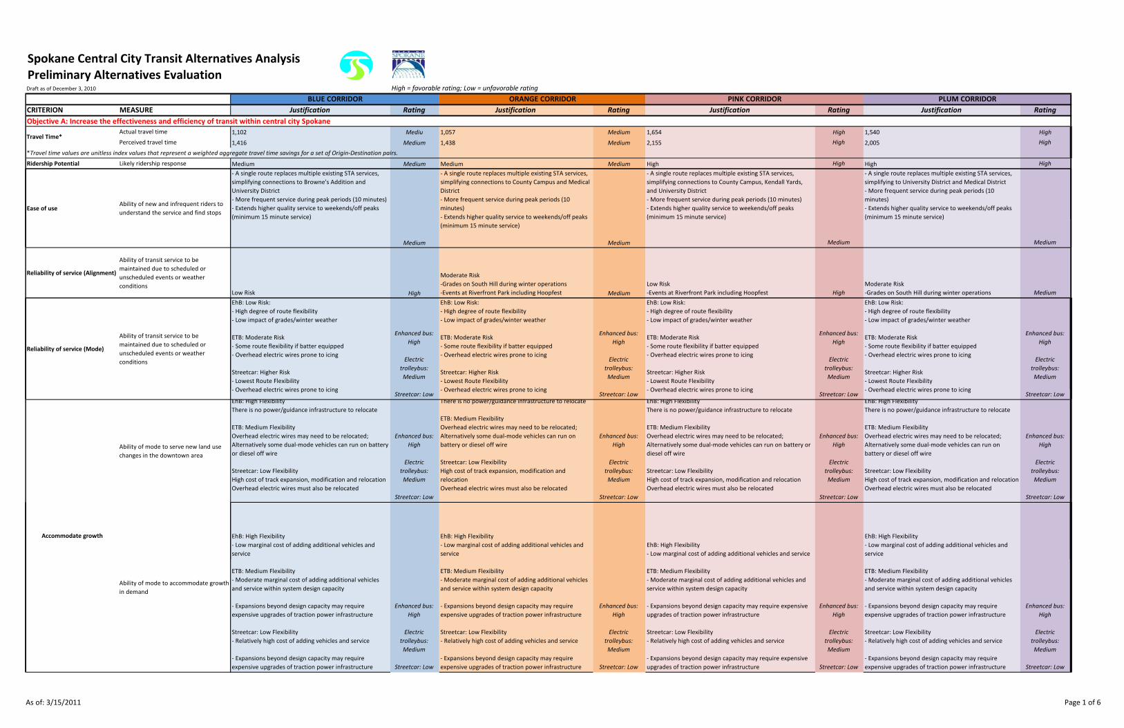
Spokane Central City Transit Alternatives AnalysisPreliminary Alternatives EvaluationDraft as of December 3, 2010 High = favorable rating; Low = unfavorable rating
CRITERION MEASURE Justification Rating Justification Rating Justification Rating Justification Rating
Actual travel time 1,102 Mediu 1,057 Medium 1,654 High 1,540 High
Perceived travel time 1,416 Medium 1,438 Medium 2,155 High 2,005 High
*Travel time values are unitless index values that represent a weighted aggregate travel time savings for a set of Origin‐Destination pairs.
Ridership Potential Likely ridership response Medium Medium Medium Medium High High High High
Ease of useAbility of new and infrequent riders to
understand the service and find stops
‐ A single route replaces multiple existing STA services,
simplifying connections to Browne's Addition and
University District
‐ More frequent service during peak periods (10 minutes)
‐ Extends higher quality service to weekends/off peaks
(minimum 15 minute service)
‐ A single route replaces multiple existing STA services,
simplifying connections to County Campus and Medical
District
‐ More frequent service during peak periods (10
minutes)
‐ Extends higher quality service to weekends/off peaks
‐ A single route replaces multiple existing STA services,
simplifying connections to County Campus, Kendall Yards,
and University District
‐ More frequent service during peak periods (10 minutes)
‐ Extends higher quality service to weekends/off peaks
(minimum 15 minute service)
‐ A single route replaces multiple existing STA services,
simplifying to University District and Medical District
‐ More frequent service during peak periods (10
minutes)
‐ Extends higher quality service to weekends/off peaks
(minimum 15 minute service)
BLUE CORRIDOR ORANGE CORRIDOR PINK CORRIDOR PLUM CORRIDOR
Objective A: Increase the effectiveness and efficiency of transit within central city Spokane
Travel Time*
( )
Medium
g q y / p
(minimum 15 minute service)
Medium
( )
Medium
( )
Medium
Reliability of service (Alignment)
Ability of transit service to be
maintained due to scheduled or
unscheduled events or weather
conditionsLow Risk High
Moderate Risk
‐Grades on South Hill during winter operations
‐Events at Riverfront Park including Hoopfest Medium
Low Risk
‐Events at Riverfront Park including Hoopfest High
Moderate Risk
‐Grades on South Hill during winter operations Medium
Reliability of service (Mode)
Ability of transit service to be
maintained due to scheduled or
unscheduled events or weather
conditions
EhB: Low Risk:
‐ High degree of route flexibility
‐ Low impact of grades/winter weather
ETB: Moderate Risk
‐ Some route flexibility if batter equipped
‐ Overhead electric wires prone to icing
Streetcar: Higher Risk
‐ Lowest Route Flexibility
‐ Overhead electric wires prone to icing
Enhanced bus:
High
Electric
trolleybus:
Medium
‐ Overhead electric wires prone to icingStreetcar: Low
‐ Overhead electric wires prone to icingStreetcar: Low
‐ Overhead electric wires prone to icingStreetcar: Low
‐ Overhead electric wires prone to icingStreetcar: Low
Ability of mode to serve new land use
changes in the downtown area
EhB: High Flexibility
There is no power/guidance infrastructure to relocate
ETB: Medium Flexibility
Overhead electric wires may need to be relocated;
Alternatively some dual‐mode vehicles can run on battery
or diesel off wire
Streetcar: Low Flexibility
High cost of track expansion, modification and relocation
Overhead electric wires must also be relocated
Enhanced bus:
High
Electric
trolleybus:
Medium
Streetcar: Low
There is no power/guidance infrastructure to relocate
ETB: Medium Flexibility
Overhead electric wires may need to be relocated;
Alternatively some dual‐mode vehicles can run on
battery or diesel off wire
Streetcar: Low Flexibility
High cost of track expansion, modification and
relocation
Overhead electric wires must also be relocated
Enhanced bus:
High
Electric
trolleybus:
Medium
Streetcar: Low
EhB: High Flexibility
There is no power/guidance infrastructure to relocate
ETB: Medium Flexibility
Overhead electric wires may need to be relocated;
Alternatively some dual‐mode vehicles can run on battery or
diesel off wire
Streetcar: Low Flexibility
High cost of track expansion, modification and relocation
Overhead electric wires must also be relocated
Enhanced bus:
High
Electric
trolleybus:
Medium
Streetcar: Low
EhB: High Flexibility
There is no power/guidance infrastructure to relocate
ETB: Medium Flexibility
Overhead electric wires may need to be relocated;
Alternatively some dual‐mode vehicles can run on
battery or diesel off wire
Streetcar: Low Flexibility
High cost of track expansion, modification and relocation
Overhead electric wires must also be relocated
Enhanced bus:
High
Electric
trolleybus:
Medium
Streetcar: Low
EhB: High Flexibility
‐ Low marginal cost of adding additional vehicles and
service
EhB: High Flexibility
‐ Low marginal cost of adding additional vehicles and
service
EhB: High Flexibility
‐ Low marginal cost of adding additional vehicles and service
EhB: High Flexibility
‐ Low marginal cost of adding additional vehicles and
service
Accommodate growth
Ability of mode to accommodate growth
in demand
ETB: Medium Flexibility
‐ Moderate marginal cost of adding additional vehicles
and service within system design capacity
‐ Expansions beyond design capacity may require
expensive upgrades of traction power infrastructure
Streetcar: Low Flexibility
‐ Relatively high cost of adding vehicles and service
‐ Expansions beyond design capacity may require
expensive upgrades of traction power infrastructure
Enhanced bus:
High
Electric
trolleybus:
Medium
Streetcar: Low
ETB: Medium Flexibility
‐ Moderate marginal cost of adding additional vehicles and
service within system design capacity
‐ Expansions beyond design capacity may require expensive
upgrades of traction power infrastructure
Streetcar: Low Flexibility
‐ Relatively high cost of adding vehicles and service
‐ Expansions beyond design capacity may require expensive
upgrades of traction power infrastructure
Enhanced bus:
High
Electric
trolleybus:
Medium
Streetcar: Low
ETB: Medium Flexibility
‐ Moderate marginal cost of adding additional vehicles
and service within system design capacity
‐ Expansions beyond design capacity may require
expensive upgrades of traction power infrastructure
Streetcar: Low Flexibility
‐ Relatively high cost of adding vehicles and service
‐ Expansions beyond design capacity may require
expensive upgrades of traction power infrastructure
Enhanced bus:
High
Electric
trolleybus:
Medium
Streetcar: Low
As of: 3/15/2011 Page 1 of 6

Spokane Central City Transit Alternatives AnalysisPreliminary Alternatives EvaluationDraft as of December 3, 2010 High = favorable rating; Low = unfavorable rating
CRITERION MEASURE Justification Rating Justification Rating Justification Rating Justification Rating
BLUE CORRIDOR ORANGE CORRIDOR PINK CORRIDOR PLUM CORRIDOR
Efficiency of the transit network
Travel time savings for the existing
system
‐Connection to other STA services via The Plaza
‐ Potential expansions to future STA HPTN routes
‐ Potential modifications to existing Browne's Addition
Routes 60, 61 to provide more efficient regional service
‐ Potential to optimize/improve Route 29 services for
outlying areas
Medium
‐Connection to other STA services via The Plaza
‐ Potential expansions to future STA HPTN routes
‐ Potential to optimize/express Monroe Corridor
Services
‐ Replacement/modification of the Route 2 Medical
Shuttle
Medium
‐Connection to other STA services via The Plaza‐ Potential
expansions to future STA HPTN routes
‐ Potential to optimize/express Monroe Corridor Services
‐ Potential to optimize/improve Route 29 services for outlying
areas
Medium
‐Connection to other STA services via The Plaza‐
Potential expansions to future STA HPTN routes
‐ Potential to optimize/improve Route 29 services for
outlying areas
‐ Replacement or modification of the Route 2 Medical
Shuttle
Medium
Objective B: Provide improved transit connections to, from, and between downtown activity areas
Number of major activity centers served 5 (2 are priority areas) High 5 (2 are priority areas) High 4 (2 are priority areas) Medium 5 (3 are priority areas) High
Number of residential dwelling units
located within 1/4 mile of the
alternative (2008) 5,100 High 3,900 Medium 3,400 Medium 4,700 High
Forecasted number of residential
dwelling units located within 1/4 mile of
the alternative (2030) 8,100 High 6,300 Low 7,600 Medium 7,700 Medium
Number of jobs located within 1/4 mile
of the alternative (2008) 26,600 Medium 31,300 High 21,800 Low 33,400 High
Forecasted number of jobs located
within 1/4 mile of the alternative (2030) 35,800 Medium 42,200 High 30,300 Low 45,000 High
Pedestrian accessibilityNumber of significant pedestrian
barriers crossed 3 Medium 4 Medium 4 Medium 6 High
Number of districts identified by the City
Transit accessibility
Objective C: Support and help stimulate new central city development and redevelopment
as priority job creation areas
1 Medium 1 Medium 2 High 1 Medium
Number of TIF districts served 1 (University District) Medium 1 (West Quadrant) Medium 2 (University District and West Quadrant) High 1 (University District) Medium
Percentage of vacant parcels within 1/4
mile of the alternative 23% High 16% Medium 22% High 20% Medium
Increased pedestrian activity at street
level: Pedestrian‐orientation rankings by
alternative
2.8.
Rating is an average of the pedestrian orientation ratings
for each street within the corridor. Streets were ranked
on a scale of 1 to 4 (4 being best) based on the presence
of pedestrian‐friendly features. Medium
3
Rating is an average of the pedestrian orientation
ratings for each street within the corridor. Streets were
ranked on a scale of 1 to 4 (4 being best) based on the
presence of pedestrian‐friendly features. High
2.3
Rating is an average of the pedestrian orientation ratings for
each street within the corridor. Streets were ranked on a
scale of 1 to 4 (4 being best) based on the presence of
pedestrian‐friendly features. Low
2.3
Rating is an average of the pedestrian orientation ratings
for each street within the corridor. Streets were ranked
on a scale of 1 to 4 (4 being best) based on the presence
of pedestrian‐friendly features. Low
Increased pedestrian activity at street
level: Percentage of vacant parcels
directly adjacent to each alternative
alignment 15.9% Medium 19.4% Medium 21.4% High 16.7% Medium
f
Urban form and activity
Objective D: Comply with and support local and regional adopted goals, objectives, and plans
Potential to create jobs and
business opportunities
Land use plans and economic
development goalsConsistency with the City of Spokane's
Comprehensive Plan
Consistent with 1 out of 1 applicable policies
‐ Encourage use of alternative forms of transportation (in
the University District) High
Consistent with 0 out of 0 applicable policies.
‐ The orange corridor does not enter the University
District and is therefore not applicable to policies
specifically for the University District ‐
Consistent with 1 out of 1 applicable policies
‐ Encourage use of alternative forms of transportation (in the
University District) High
Consistent with 1 out of 1 applicable policies
‐ Encourage use of alternative forms of transportation
(in the University District) High
Consistency with the Riverpoint Campus
Master Plan Consistent with 7 out of 7 applicable policies. High
Consistent with 7 out of 7 applicable policies.
‐ Orange Corridor exclusive objective in compliance:
Improve access to Riverfront Park and Spokane River
for all modes of travel High
Consistent with 8 out of 8 applicable policies.
‐ Pink Corridor exclusive objective in compliance: Develop
Kendall Yards and establish strong links to Downtown Core High Consistent with 7 out of 7 applicable policies High
Consistency with the Fast Forward
Spokane: Downtown Plan Update Consistent with 6 out of 6 applicable policies High
Consistent with 0 out of 0 applicable policies.
‐ The orange corridor does not enter the Univeristy
District and is therefore not applicable to policies
specifically for the University District ‐ Consistent with 6 out of 6 applicable policies High Consistent with 6 out of 6 applicable policies High
As of: 3/15/2011 Page 2 of 6

Spokane Central City Transit Alternatives AnalysisPreliminary Alternatives EvaluationDraft as of December 3, 2010 High = favorable rating; Low = unfavorable rating
CRITERION MEASURE Justification Rating Justification Rating Justification Rating Justification Rating
BLUE CORRIDOR ORANGE CORRIDOR PINK CORRIDOR PLUM CORRIDOR
Consistency with the University District
Master Plan
Serves 1 out of 7 TAD Districts and 1 TIF district.
‐ This includes the University District TAD and the
University District Revitalization Area TIF. Medium
Serves 1 out of 7 TAD districts and 1 TIF district.
‐ This includes the North Bank TAD and the West
Quadrant TIF. Medium
Serves 2 out of 7 TAD districts and 2 TIF districts.
‐ This includes North Bank and University Districts TADs and
the West Quadrant and University District Revitalization Area
TIFs. Medium
Serves 1 out of 7 TAD districts and 1 TIF district.
‐ This includes the University District TAD and the
University District Revitalization Area TIF. Medium
Consistency with Shoreline Master
P
The Shoreline Master program dictates that every effort
must be made to protect views of the water.
‐ The Blue corridor may include a view of the water from
the Spokane Falls Bridge, and may potentially obstruct
views temporarily for some pedestrians. However, this is
less than the potential impact from the Pink corridor,
hi h h i i Hi h
The Shoreline Master program dictates that every
effort must be made to protect views of the water.
‐ The Orange corridor may include a view of the water
from the Monroe St Bridge, and may potentially
obstruct views temporarily for some pedestrians.
However, this is less than the potential impact from the
Pi k id hi h h i i Hi h
The Shoreline Master program dictates that every effort must
be made to protect views of the water.
‐ The Pink corridor may include a view of the water from both
the Monroe St Bridge and the Spokane Falls bridge, and may
potentially obstruct views temporarily for some pedestrians
i b h l M di
The Shoreline Master program dictates that every effort
must be made to protect views of the water.
‐ The Plum corridor may include a view of the water
from the Spokane Falls bridge, and may potentially
obstruct views temporarily for some pedestrians.
However, this is less than the potential impact from the
Pi k id hi h h i i Hi hProgram which crosses the river twice. High Pink corridor, which crosses the river twice. High in both places. Medium Pink corridor, which crosses the river twice. High
Support of Targeted Area Development
districts
Corridor aligns with 7 HPTN routes:
‐ G2 and G5 from Browne's Addition to the University
District
‐ B1 and B2 from West Downtown to the University
District
‐ R1 from West Downtown to East Downtown
‐ R2 and G3 from Downtown Core to East Downtown High
Corridor approxmately aligns with 2 HPTN routes:
‐ G1 and G4 from Medical West to County Campus
* Many of the HPTN routes through downtown run east‐
west and and include the University District; the Orange
Corridor doesn't score well here because it runs north‐
south and doesn't include the University District Medium
Corridor aligns with 7 HPTN routes:
‐ G2, G5, B1, and B2 from Downtown Core to the University
District
‐ R1, R2, and G3 from the Downtown Core to East Downtown High
Corridor aligns with 7 HPTN routes:
‐ G2, G5, B1, and B2 from Downtown Core to the
University District
‐ R1, R2, and G3 from the Downtown Core to East
Downtown High
Consistency with STA's HPTN Plan
‐ G2 and G5 from Browne's Addition to the University
District High
‐ G1 and G4 from Medical West to County Campus
* Many of the HPTN routes through downtown run east‐ Medium
‐ G2, G5, B1, and B2 from Downtown Core to the University
District High
‐ G2, G5, B1, and B2 from Downtown Core to the
University District High
Consistency with Metropolitan
Transportation Plan
‐ Development focused along transit corridors
‐ Enhance major activity centers currently served by High
Consistent with 6 out of 6 applicable policies
* see Blue Corridor for the 6 policies High
Consistent with 6 out of 6 applicable policies
* see Blue Corridor for the 6 policies High
Consistent with 6 out of 6 applicable policies
* see Blue Corridor for the 6 policies High
Consistency with the Spokane Regional
Pedestrian Plan
‐ Increase pedestrian trips from 8.5% to 10%
‐ Provide pedestrian infrastructure High
Consistent with 6 out of 6 applicable policies
* see Blue Corridor for the 6 policies High
Consistent with 6 out of 6 applicable policies
* see Blue Corridor for the 6 policies High
Consistent with 6 out of 6 applicable policies
* see Blue Corridor for the 6 policies High
Consistent with 5 out of 5 applicable policies:
‐ Reduce drive alone trips by 10% and VMT by 13% for
employees at CTR‐affected work sites
Consistency with the Growth and
Transportation Efficiency Plan
employees at CTR‐affected work sites
‐ Reduce drive alone trips by 10% for employees at
unaffected work sites
‐ Reduce drive alone trips by 10% among selected
residential groups
‐ Convert an additional 1,000 commuters to drive‐alone
travel options for the entire GTEC area
‐ Reduce drive alone trips by 10% and VMT by 13% for the
entire city High
Consistent with 5 out of 5 applicable policies
* see Blue Corridor for the 5 policies High
Consistent with 5 out of 5 applicable policies
* see Blue Corridor for the 5 policies High
Consistent with 5 out of 5 applicable policies
* see Blue Corridor for the 5 policies High
Consistency with Connect Spokane ‐
Comprehensive Plan for Transportation
Consistent with 7 out of 7 applicable policies:
Consistent with:
‐ Routes should not travel along corridors that have
physical barriers, such as rivers
‐ Routes to have utility independent of transfers
‐ Routes to focus on generalized service
‐ Routes to serve multiple destinations
‐ Serve The Plaza
‐ Accommodate bicycles
‐ Provide pedestrian infrastructure High
Consistent with 7 out of 7 applicable policies
* See Orange Corridor for 7 policies High
Consistent with 7 out of 7 applicable policies
* See Orange Corridor for 7 policies High
Obj i E O i i fi l i i l i i i f d i
Transportation plans
Projected capital cost
Enhanced Bus: $3m ‐ $4.5m per mile
Electric Trolley Bus: $6m ‐ $9m per mile
Streetcar: $34m ‐ $51m per mile
Enhanced Bus:
High
Electric Trolley
Bus: Medium
Streetcar: Low
Enhanced Bus: $3m ‐ $4.5m per mile
Electric Trolley Bus: $6m ‐ $9m per mile
Streetcar: $34m ‐ $51m per mile
Enhanced Bus:
High
Electric Trolley
Bus: Medium
Streetcar: Low
Enhanced Bus: $3m ‐ $4.5m per mile
Electric Trolley Bus: $6m ‐ $9m per mile
Streetcar: $34m ‐ $51m per mile
Enhanced Bus:
High
Electric Trolley
Bus: Medium
Streetcar: Low
Enhanced Bus: $3m ‐ $4.5m per mile
Electric Trolley Bus: $6m ‐ $9m per mile
Streetcar: $34m ‐ $51m per mile
Enhanced Bus:
High
Electric Trolley
Bus: Medium
Streetcar: Low
Projected operating cost*
Enhanced Bus: $7.18 per vehicle revenue mile
Electric Trolley Bus2: $14.61 per vehicle revenue mile
Streetcar: $12.12 per vehicle revenue mile
Enhanced Bus:
High
Electric Trolley
Bus: Medium
Streetcar: Low
Enhanced Bus: $7.18 per vehicle revenue mile
Electric Trolley Bus2: $14.61 per vehicle revenue mile
Streetcar: $12.12 per vehicle revenue mile
Enhanced Bus:
High
Electric Trolley
Bus: Medium
Streetcar: Low
Enhanced Bus: $7.18 per vehicle revenue mile
Electric Trolley Bus2: $14.61 per vehicle revenue mile
Streetcar: $12.12 per vehicle revenue mile
Enhanced Bus:
High
Electric Trolley
Bus: Medium
Streetcar: Low
Enhanced Bus: $7.18 per vehicle revenue mile
Electric Trolley Bus2: $14.61 per vehicle revenue mile
Streetcar: $12.12 per vehicle revenue mile
Enhanced Bus:
High
Electric Trolley
Bus: Medium
Streetcar: Low
*Operating costs for electric trolleybus are based on a small sample size, and therefore they should be considered less reliable than estimates for streetcar and enhanced bus.
Affordability
Objective E: Optimize fiscal investments in central city transit infrastructure and service
As of: 3/15/2011 Page 3 of 6

Spokane Central City Transit Alternatives AnalysisPreliminary Alternatives EvaluationDraft as of December 3, 2010 High = favorable rating; Low = unfavorable rating
CRITERION MEASURE Justification Rating Justification Rating Justification Rating Justification Rating
BLUE CORRIDOR ORANGE CORRIDOR PINK CORRIDOR PLUM CORRIDOR
FTA Potential Sources:
‐Section 5309 Capital Investment Grant program*
‐Urban Circulator
‐TIGER/TIGGER
*Note: Small Starts federal funding allocation is limited to
$75 million. Any funds needed above that will need to
come from other sources.
State funding sources:
WSDOT Public Transportation Grant
Enhanced Bus:
Low
FTA Potential Sources:
‐Section 5309 Capital Investment Grant program*
‐Urban Circulator
‐TIGER/TIGGER
*Note: Small Starts federal funding allocation is limited
to $75 million. Any funds needed above that will need
to come from other sources.
State funding sources:
WSDOT Public Transportation Grant
Enhanced Bus:
Low
FTA Potential Sources:
‐Section 5309 Capital Investment Grant program*
‐Urban Circulator
‐TIGER/TIGGER
*Note: Small Starts federal funding allocation is limited to
$75 million. Any funds needed above that will need to come
from other sources.
State funding sources:
WSDOT Public Transportation Grant
Enhanced Bus:
Low
FTA Potential Sources:
‐Section 5309 Capital Investment Grant program*
‐Urban Circulator
‐TIGER/TIGGER
*Note: Small Starts federal funding allocation is limited
to $75 million. Any funds needed above that will need to
come from other sources.
State funding sources:
WSDOT Public Transportation Grant
Enhanced Bus:
LowAvailability of funding
Potential capital cost funding source(s)
‐WSDOT Public Transportation Grant
‐WSDOT Regional Mobility Grant
A high rating indicates more potential funding sources.
Low
Electric
Trolleybus: High
Streetcar: High
‐WSDOT Public Transportation Grant
‐WSDOT Regional Mobility Grant
A high rating indicates more potential funding sources.
Low
Electric
Trolleybus: High
Streetcar: High
‐WSDOT Public Transportation Grant
‐WSDOT Regional Mobility Grant
A high rating indicates more potential funding sources.
Low
Electric
Trolleybus: High
Streetcar: High
‐WSDOT Public Transportation Grant
‐WSDOT Regional Mobility Grant
A high rating indicates more potential funding sources.
Low
Electric
Trolleybus: High
Streetcar: High
Potential operating cost funding
source(s)
Examples from other systems include:
‐fares
‐sales tax
‐payroll tax
‐corporate sponsorship of stations
‐endowments
‐parking meter revenues
Enhanced Bus:
Low
Electric
Trolleybus: High
Streetcar: High
Examples from other systems include:
‐fares
‐sales tax
‐payroll tax
‐corporate sponsorship of stations
‐endowments
‐parking meter revenues
Enhanced Bus:
Low
Electric
Trolleybus: High
Streetcar: High
Examples from other systems include:
‐fares
‐sales tax
‐payroll tax
‐corporate sponsorship of stations
‐endowments
‐parking meter revenues
Enhanced Bus:
Low
Electric
Trolleybus: High
Streetcar: High
Examples from other systems include:
‐fares
‐sales tax
‐payroll tax
‐corporate sponsorship of stations
‐endowments
‐parking meter revenues
Enhanced Bus:
Low
Electric
Trolleybus: High
Streetcar: High
Leverage
Potential to leverage other
public/private investments
Examples from other systems show that rail‐based modes
encourage development to a greater degree than bus‐
based modes.
Enhanced Bus:
Low
Electric
Trolleybus:
Medium
Streetcar: High
Examples from other systems show that rail‐based
modes encourage development to a greater degree
than bus‐based modes.
Enhanced Bus:
Low
Electric
Trolleybus:
Medium
Streetcar: High
Examples from other systems show that rail‐based modes
encourage development to a greater degree than bus‐based
modes.
Enhanced Bus:
Low
Electric
Trolleybus:
Medium
Streetcar: High
Examples from other systems show that rail‐based
modes encourage development to a greater degree than
bus‐based modes.
Enhanced Bus:
Low
Electric
Trolleybus:
Medium
Streetcar: High
Up to 11 90‐degree turns. 90‐degree turns are likely to
Enhanced bus:
High Up to 9 90‐degree turns. 90‐degree turns are likely to
Enhanced bus:
High
Objective F: Optimize the engineering design and environmental sensitivity of the project
Number of parcels of land directly
affected by the project
Up to 7 90‐degree turns included. 90‐degree turns are
likely to necessitate small takings of ROW in order to
accommodate electric trolleybus or streetcar. The lower
amount of turns in this corridor indicates that there are
likely to be fewer ROW takings.
Enhanced bus:
High
Electric
trolleybus: High
Streetcar: High
p g g y
necessitate small takings of ROW in order to
accommodate electric trolleybus or streetcar. The
amount of turns in this corridor indicates that there are
likely to be fewer ROW takings than in the Plum
corridor, but more than in the Blue or Pink corridor.
g
Electric
trolleybus:
Medium
Streetcar:
Medium
p g g y
necessitate small takings of ROW in order to accommodate
electric trolleybus or streetcar. The amount of turns in this
corridor indicates that there would likely be fewer ROW
takings than in the Orange or Plum corridors, but more than
in the Blue corridor.
g
Electric
trolleybus:
Medium
Streetcar:
Medium
Up to 16 90‐degree turns. 90‐degree turns are likely to
necessitate small takings of ROW in order to
accommodate electric trolleybus or streetcar. The
amount of turns in this corridor indicates that there
would likely be the most ROW takings of all 4 corridors.
Enhanced bus:
High
Electric
trolleybus: Low
Streetcar: Low
Number of historic properties
potentially affectedQuarter mile buffer of the corridor includes:
3 historic districts (Browne's Addition, West Downtown,
East Downtown)
14 buildings on the National Register
1 building on the state register Low
Quarter mile buffer of the corridor includes:
2 historic districts (West Downtown, East Downtown)
15 buildings on the National Register
Monroe Street Bridge (on the National Register)
1 building on the State Register
1 district on the State Register (River District) Low
Quarter mile buffer of the corridor includes:
2 historic districts (West Downtown, East Downtown)
12 buildings on the National Register
Monroe Street Bridge
2 buildings on the State Register
1 district on the State Register (River District)
Because there are fewer historic properties in this buffer, the
alternative is rated higher due to the lower probability of
impacting a historic resource. Medium
Quarter mile buffer of the corridor includes:
2 historic districts (West Downtown, East Downtown)
15 buildings on the National Register
1 building on the State Register
Because there are fewer historic properties in this
buffer, the alternative is rated higher due to the lower
probability of impacting a historic resource. Medium
Number of 4(f) properties potentiallyPotential to impact parks:
Coeur d'Alene Park No
Potential to impact parks:
North Bank Park Maybe (Howard Street Option) Potential to impact parks:
Environmental impacts
Number of 4(f) properties potentially
usedCoeur d'Alene Park ‐ No
South Maple Street Parkway ‐ Maybe
Riverside‐Cedar Parkway ‐ Yes, for the North option along
Riverside Avenue Medium
North Bank Park ‐ Maybe (Howard Street Option)
Riverfront Park ‐ Yes (Howard Street Option)
Riverfront Park ‐ No (Monroe Street option)
Pioneer Park ‐ No (Stevens Street option) Medium
Potential to impact parks:
Riverfront park ‐ Maybe
Riverside‐Cedar Parkway ‐ No (though directly adjacent, this
alternative only impacts the very end of the parkway) High
Potential to impact parks:
Riverside‐Cedar Parkway ‐ No
Pioneer Park ‐ No High
Number of noise‐sensitive land uses
adjacent to the alternative
Adjacent to up to 23 noise‐sensitive properties
(residential areas, churches, day cares, libraries and
others) Medium
Adjacent to up to 19 noise‐sensitive properties
(residential areas, churches, day cares, libraries, and
others) Medium
Adjacent to up to 21 noise‐sensitive properties (residential
areas, churches, day cares, libraries, and others) Medium
Adjacent to up to 21 noise‐sensitive properties
(residential areas, churches, day cares, libraries, and
others) Medium
Approximate number of low‐income
persons within 1/4 mile of the
alternative 4,300 (70%) High 3,200 (64%) High 2,900 (70%) High 3,300 (68%) High
As of: 3/15/2011 Page 4 of 6

Spokane Central City Transit Alternatives AnalysisPreliminary Alternatives EvaluationDraft as of December 3, 2010 High = favorable rating; Low = unfavorable rating
CRITERION MEASURE Justification Rating Justification Rating Justification Rating Justification Rating
BLUE CORRIDOR ORANGE CORRIDOR PINK CORRIDOR PLUM CORRIDOR
Approximate number of persons of a
minority race or ethnicity within 1/4
mile of the alternative 1,100 (15%) Medium 1,000 (17%) High 900 (17%) High 900 (15%) Medium
Approximate number of transit‐inclined
persons within 1/4 mile of the
alternative
The transit inclination map rates areas according to the
relative number of transit inclined people. (scale is 1‐5,
with 5 being the most people). This corridor serves:
‐ Browne's Addition (4)
‐ Riverside (5)
‐ Logan (4) Medium
The transit inclination map rates areas according to the
relative number of transit inclined people. (scale is 1‐5,
with 5 being the most people). This corridor serves:
‐ Riverside (5)
‐ East Central (4) High
The transit inclination map rates areas according to the
relative number of transit inclined people. (scale is 1‐5, with 5
being the most people). This corridor serves:
‐ Riverside (5)
‐ West Central (3)
‐ Logan (4) Medium
The transit inclination map rates areas according to the
relative number of transit inclined people. (scale is 1‐5,
with 5 being the most people). This corridor serves:
‐ Riverside (5)
‐ East Central (4)
‐ Logan (4) Medium
Equity
Enhanced Bus:
• None. Use existing E Spokane Falls Blvd Bridge. Minor
modifications required.
Electric Trolley Bus:
• None Use existing E Spokane Falls Blvd Bridge Minor
Enhanced Bus:
• None if on N Monroe Street.
• None if on N Post Street but major modifications
required.
• One (south) if on Howard Street. Moderate to major
modifications to the middle and north bridges would be
required.
Electric Trolley Bus:
• None if on N Monroe Street. Minor modifications
required.
• None if on N Post Street but major modifications
required.
• One (south) if on Howard Street. Moderate to major
modifications to the middle and north bridges would be
required.
Streetcar:
• None if on N Monroe Street. Moderate modifications
required
Enhanced Bus:
• None if on N Monroe Street.
• None if on N Post Street but major modifications required.
• One (south) if on Howard Street. Moderate to major
modifications to the middle and north bridges would be
required.
• Use existing E Spokane Falls Blvd bridge with no
modification.
Electric Trolley Bus:
• None if on N Monroe Street. Minor modifications required.
• None if on N Post Street but major modifications required.
• One (south) if on Howard Street. Moderate to major
modifications to the middle and north bridges would be
required.
• Use existing E Spokane Falls Blvd bridge with minor
modification.
Streetcar:
• None if on N Monroe Street. Moderate modifications
required.
• One if on N Post Street
Enhanced Bus:
• None. Use existing E Spokane Falls Blvd Bridge. Minor
modifications required.
Electric Trolley Bus:
• None Use existing E Spokane Falls Blvd Bridge Minor
Number of new river crossings needed
• None. Use existing E Spokane Falls Blvd Bridge. Minor
modifications required.
Streetcar:
• None. Use existing E Spokane Falls Blvd Bridge.
Moderate modifications required. High
required.
• One if on N Post Street.
• Two (south and north) if on Howard Street. Moderate
to major modifications to the middle bridge would be
required. Low
• One if on N Post Street.
• Two (south and north) if on Howard Street. Moderate to
major modifications to the middle bridge would be required.
• Use existing E Spokane Falls Blvd bridge with moderate
modification. Low
• None. Use existing E Spokane Falls Blvd Bridge. Minor
modifications required.
Streetcar:
• None. Use existing E Spokane Falls Blvd Bridge.
Moderate modifications required. High
Enhanced Bus
• Route alternatives should avoid running along Browne,
Division and Hamilton due to heavy auto and truck traffic
Enhanced Bus
• Fairly high auto and truck traffic on Lincoln and
Monroe
Electric Trolley Bus
• Same as for Enhanced Bus plus:
‐ Access to the Medical District via all of the existing
access points through the railroad and I‐90 would
require a dedicated transit lane under the overpasses
due to non‐code compliant vertical clearance below the
trolley wire
‐ Access from east downtown via Stevens or Wall is a
fatal‐flaw due to the 11’‐6” vertical clearance (Stevens)
or 11'‐4" vertical clearance (Wall) under the railroad
Enhanced Bus
• Fairly high auto and truck traffic on Lincoln and
Monroe
• Route alternatives should avoid running along
Browne, Division and Hamilton due to heavy auto and
truck traffic
Electric Trolley Bus
• Same as for Enhanced Bus plus:
‐ Access to the Medical District via all of the existing
access points through the railroad and I‐90 would
require a dedicated transit lane under the overpasses
due to non‐code compliant vertical clearance below the
trolley wire.
‐ Access from east downtown via Stevens or Wall is a
fatal‐flaw due to the 11’‐6” vertical clearance (Stevens)
Constructability
Major design considerations
Electric Trolley Bus
• Same as for Enhanced Bus
Streetcar
• Same as for Enhanced Bus and Electric Trolley Bus
plus:
‐ Small traffic concern with introducing a fixed
guideway transit mode in the complicated
Maple/Walnut/Riverside/Pacific intersection
‐ Design of the bridge deck modification (E Spokane
Falls Blvd) will require detailed investigation of the
existing structure High (all modes)
unless major reconstruction of the road or railroad
bridge is done
Streetcar
• Same as for Enhanced Bus and Electric Trolley Bus
plus:
‐ Grades in excess of 9% south of I‐90 limit route
options. A Lincoln/Monroe couplet to W 5th Ave
appears feasible
‐ Design of the bridge deck modification (N Monroe
St) will require detailed investigation of the existing
structure
Enhanced bus:
High; Electric
Trolley Bus:
Medium;
Streetcar:
Medium
Enhanced Bus
• Fairly high auto and truck traffic on Monroe
• Route alternatives should avoid running along Browne,
Division and Hamilton due to heavy auto and truck traffic
Electric Trolley Bus
• Same as for Enhanced Bus
Streetcar
• Same as for Enhanced Bus and Electric Trolley Bus plus:
‐ Design of the bridge deck modification for E Spokane Blvd
and N Monroe Street will require detailed investigation of
the existing structure High (all modes)
or 11'‐4" vertical clearance (Wall) under the railroad
unless major reconstruction of the road or railroad
bridge is done
Streetcar
• Same as for Enhanced Bus and Electric Trolley Bus
plus:
‐ Grades in excess of 9% south of I‐90 limit route
options. A Lincoln/Monroe couplet to W 5th Ave
appears feasible
‐ Design of the bridge deck modification (E Spokane
Falls Blvd) will require detailed investigation of the
Enhanced bus:
High; Electric
Trolley Bus:
Medium;
Streetcar:
Medium
As of: 3/15/2011 Page 5 of 6

Spokane Central City Transit Alternatives AnalysisPreliminary Alternatives EvaluationDraft as of December 3, 2010 High = favorable rating; Low = unfavorable rating
CRITERION MEASURE Justification Rating Justification Rating Justification Rating Justification Rating
BLUE CORRIDOR ORANGE CORRIDOR PINK CORRIDOR PLUM CORRIDOR
Energy conservation Reduction in greenhouse gases
Enhanced Bus:
‐ Likely to be dependent on GHG‐generating energy
source (fossil fuel/biofuel)
‐ Diesel‐Electric Hybrid vehicles are highly cost effective
per ton of GHG reduced
‐ Low carbon cost of infrastructure development
Electric Trolleybus:
‐ Can be a zero‐carbon mode depending upon source of
electric power
‐ High cost per ton of GHG reduced
‐ Low carbon cost of infrastructure development
Enhanced Bus:
Medium
Enhanced Bus:
‐ Likely to be dependent on GHG‐generating energy source
(fossil fuel/biofuel)
‐ Diesel‐Electric Hybrid vehicles are highly cost effective per
ton of GHG reduced
‐ Low carbon cost of infrastructure development
Electric Trolleybus:
‐ Can be a zero‐carbon mode depending upon source of
electric power
‐ High cost per ton of GHG reduced
‐ Low carbon cost of infrastructure development
Enhanced Bus:
Medium
Enhanced Bus:
‐ Likely to be dependent on GHG‐generating energy
source (fossil fuel/biofuel)
‐ Diesel‐Electric Hybrid vehicles are highly cost effective
per ton of GHG reduced
‐ Low carbon cost of infrastructure development
Electric Trolleybus:
‐ Can be a zero‐carbon mode depending upon source of
electric power
‐ High cost per ton of GHG reduced
‐ Low carbon cost of infrastructure development
Enhanced Bus:
Mediump
Streetcar:
‐ Can be a zero‐carbon mode depending upon source of
electric power
‐ High cost per ton of GHG reduced
‐ Carbon cost of heavy construction needs to be
considered
Electric
Trolleybus:
Medium/High
Streetcar:
Medium
p
Streetcar:
‐ Can be a zero‐carbon mode depending upon source of
electric power
‐ High cost per ton of GHG reduced
‐ Carbon cost of heavy construction needs to be
considered
Electric
Trolleybus:
Medium/High
Streetcar:
Medium
p
Streetcar:
‐ Can be a zero‐carbon mode depending upon source of
electric power
‐ High cost per ton of GHG reduced
‐ Carbon cost of heavy construction needs to be considered
Electric
Trolleybus:
Medium/High
Streetcar:
Medium
p
Streetcar:
‐ Can be a zero‐carbon mode depending upon source of
electric power
‐ High cost per ton of GHG reduced
‐ Carbon cost of heavy construction needs to be
considered
Electric
Trolleybus:
Medium/High
Streetcar:
Medium
As of: 3/15/2011 Page 6 of 6

9. Appendix B: Summary of Stakeholder
Preference Survey Results

This page left blank intentionally.

Central City Transit Alternatives Analysis
Stakeholder Preference Survey
Prepared for: Downtown Spokane Partnership Business Improvement District University District Development Association Prepared by: Spokane Transit Authority Final 5/18/2011
Upon request, alternative formats of this document will
be produced for people with disabilities. Please call 325-
6094 or TTY (509) 232-6555 or email

This page left blank intentionally.

Stakeholder Preference Survey ii Central City Transit Alternatives Analysis Final 5/18/2011
Table of Contents Introduction ................................................................................................................................ 3
Survey Question Results ............................................................................................................. 3
Question 1: Project Understanding ........................................................................................ 3
Question 2: Project Criteria .................................................................................................... 4
Question 3: Downtown Projects ............................................................................................. 5
Question 4: Infrastructure, Policies, Incentives ...................................................................... 5
Question 5: Streetcar Advantages .......................................................................................... 6
Question 6: Streetcar Disadvantages...................................................................................... 8
Question 7: Streetcar Other Actions ....................................................................................... 9
Question 8: Streetcar Development ..................................................................................... 10
Question 9: Electric Trolley Bus Advantages ........................................................................ 11
Question 10: Electric Trolley Bus Disadvantages .................................................................. 12
Question 11: Electric Trolley Bus Other Actions ................................................................... 13
Question 12: Electric Trolley Bus Development ................................................................... 14
Question 13: Enhanced Bus Advantages .............................................................................. 15
Question 14: Enhanced Bus Disadvantages .......................................................................... 16
Question 15: Enhanced Bus Other Actions ........................................................................... 17
Question 16: Enhanced Bus Development ........................................................................... 18
Question 17: Project Support ............................................................................................... 19

This page left blank intentionally.

Central City Transit Alternatives Analysis 3 Spokane Transit Authority Final 5/18/2011
Introduction
The following report provides detailed results from the survey about the modes being
considered in the Central City Transit Alternatives Analysis. Members of the Business
Improvement District Board, Downtown Spokane Partnership Board, University District
Development Association Board and other major property owners along the preliminarily
preferred Central City Transit corridor. Responses were collected between April 25th and May
16th of 2011. 51 responses were collected; because some respondents did not answer every
question, the number of answers for each question may vary. The numbers associated with
each response are for reference purposes only. The responses have been sorted in alphabetical
order and therefore each number does not correspond with a particular survey throughout this
report.
Survey Question Results
Question 1: Project Understanding
Have you attended a presentation, open house or reviewed information regarding the Central
City Transit Alternatives Analysis?
0%
10%
20%
30%
40%
50%
60%
70%
80%
90%
100%
Yes No

Central City Transit Alternatives Analysis 4 Spokane Transit Authority Final 5/18/2011
Question 2: Project Criteria
In your opinion, how important are the individual project criteria when deciding which mode
should be constructed along the proposed alignment? (4 = Most Important, 1 = Least
Important)
0 1 2 3 4
The ability of the mode to improve the efficiency and effectiveness of the transit system.
The positive influence the mode will have on economic development and the built
environment.
The financial investments in the mode are optimal given the competing investments and
services.
The environmental sensitivity of the mode.

Central City Transit Alternatives Analysis 5 Spokane Transit Authority Final 5/18/2011
Question 3: Downtown Projects
Of the projects currently being planned and considered in the Central City, please rank their
importance they merit in improving the Central City. (4 = Most Important, 1 = Least
Important)
Question 4: Infrastructure, Policies, Incentives
This project will require a direct investment in transit infrastructure and service operation.
What other infrastructure, policies or incentives do you think need to be in place for this
transit project to become a success considering the goal of the project?
1 1. Adoption of code elements that permit residential in-fill in urban and near-urban neighborhoods surrounding Downtown. 2. Construction and occupation of 1,000+ more units. We need a clear path to greater residential density before we can consider paying even for a dedicated bus line.
2
A clearly outline development strategy to facilitate the rapid development of infill sites along the route. For example, an incentive program could be that a "new" development could forgo property tax assessment during the life of a 10-year LID contribution. Or perhaps they could simply forgo "increased assessments" for that 10 year period. Building the system is only a portion of the solution to infill the sea of parking lots and one level building in downtown. Incentives, or bottom line motivation, are absolutely necessary to encourage GOOD development.
3
A Port District - to retain the emphasis on measureable economic development improvements instead of efficiency and effectiveness of system wide transit operations. I don't view this as a "transit project". It is a project about continuing the growth of our Downtown as an economic engine and the entire region as a highly sought after, competitive destination.
4 City development standards that encourage and facilitate high density development along the route. Division St. gateway improvements and way finding.
5 Employer incentives for participating in transit ridership
6 Housing on the east end not Sprague
7 I believe the bus stops should be "themed" for the area/district to include "way finding" and merchant advertising.
8 Incentives must be provided to local landowners so they will develop their properties along the route, a plan must be put in place to fairly share the cost among riders and land owners
0 1 2 3 4
University District Pedestrian/Bicycle …
Central City Transit Line
Downtown Wayfinding System
Division Street Linear Gateway
Upgrade Street Tree System

Central City Transit Alternatives Analysis 6 Spokane Transit Authority Final 5/18/2011
9 North-South transit, Airport to city transit
10 Not sure, but incentives to private developers who invest in the construction process seems appropriate.
11
Only other infrastructure needed is political will and good leadership from our local electeds. Alas...that will be the toughest hurdle to overcome. Other than that....the city really needs to fix its "change of use" policy...otherwise there will be no development around the transit system because it'll be too difficult and expensive.
12 Park & ride available, friendly bike routes in the same area
13
Parking issues will need to be addressed in the neighborhoods at the east/west ends of the line. Parking overall is a area that the City needs to address seriously, and as over-used as it is as an example, Portland is a great model for the City's involvement in addressing parking needs in the core.
14 Parking policy needs to be resolved and implemented, expansion of BID into surrounding neighborhood business districts, infill and change of use requirements must be updated and ready for implementation
15 Policy of few/no new roads for vehicles; focus on maintaining current street system and providing alternative transportation, including transit.
16 Property tax abatement should be extended for a period of 5 - 10 years to encourage commercial development along the proposed route.
17
Realistic expectations for what this transit line will accomplish; a heavy, creative marketing campaign to excite the community about what this could be; financial responsibility to show the community that STA cares about investment to product ratios...does it make sense to spend hundreds of millions on a train when a really nice and consistent bus system will accomplish what the train will do and more?
18 Regulatory and zoning environment and attitude compatible with the required density to enable it to be successful.
19 Service should include a free zone.
20 The system must be VERY convenient and desirable to the riders; fares cheaper than parking, frequency of pickups (every ten minutes or so), proper security on the mode of transportation.
21 There is a need to encourage the development of more housing in the U-District area. The residents of this new housing would increase ridership.
22 This should be a part of a comprehensive review and fit within the city's comprehensive plan. At this point, given the limited resources, this proposal does not meet the short-term requirements for the city's top needs.
23 Tie workplace incentives to ridership. Get creative on really increasing ridership for all. Incent the behavior to get it to catch on by having businesses have incentives to get employees to ride.
24 Upgrade sidewalk system to remedy safety and major aesthetic deficiencies. Provide density, height, signage or other incentives to property owners along the chosen route who opt in to street level upgrades. If an LID is formed, study including sidewalks.
25 Wayfinding.
Question 5: Streetcar Advantages
What do you believe are the advantages of implementing the streetcar option?
1 A unique character that will attract riders that typically will not use public transit. The fixed track gives greater confidence to developers that the route is there to stay.
2 Aesthetics and the urban feel of a streetcar.
3 Appeal. Greater access for more categories of riders.
4 Connectivity to our most central and important districts. Economic impact on our local economy. Creating a more pedestrian friendly downtown. Just to be cool!
5 Different - somewhat of a tourist attraction. Make them like the San Francisco cable cars so that each stop is short. - many people get on and off quickly.
6 Easier for people to move around downtown
7 Easy to identify route. Allows Spokane to promote itself as a contemporary destination. Keep up with

Central City Transit Alternatives Analysis 7 Spokane Transit Authority Final 5/18/2011
the west side.
8 Economic Development
9 Economic development, Civic accomplishment, Making a positive statement that Spokane is really first class city, Better downtown transit
10 Establishing the route with a high degree of permanency, giving property owners and developers confidence that the route chosen will remain the route for the foreseeable future. It also has the most appeal from an emotional standpoint - the tracks differentiate it from other modes of transportation.
11 Fixed route seen as permanent investment
12 Fixed route service encourages economic development
13 Fixed route with increased frequency to high traffic users.
14 From the PowerPoint printout I was handed, my understanding is it's more appealing to users and moves more people. From my experience in other cities, it removes the barrier of feeling like it's being in a car navigating traffic. Speeds flow of traffic and has a "cool factor."
15 Higher ridership due to panache of a street car and the visibility of permanent tracks
16 Increased attractiveness to employers to locate downtown. Enhanced retail environment. Less demand for surface parking. Increased infill development potential. Enhanced property tax base.
17 Increased economic benefits connecting users to the retail/office core.
18 It is the only option that has the permanence to deliver meaningful investment and development activity. It does not crowd Downtown views with a web of wires. It has a "with it" factor that neither of the other modes can deliver.
19 Local transportation and identity of vehicles different from the standard bus.
20 Makes for a natural link between the three different districts. Provides a certain flair to downtown that would help it's appeal to out of town visitors.
21 None
22 None
23 None
24 Overall appeal of riding a streetcar. Gives the city some distinction.
25 Permanency
26 Permanent boarding stations; commitment to transit-oriented development
27 Permanent Infrastructure, a community attraction, a step outside the Spokane "norm,"
28 Permanent transportation, Impressive scope, Consistent routes
29 Quaint feel downtown, alleviate some traffic flow with reliable transportation
30 Safety, eases congestion, environmental impact
31 Sense of permanence for investors
32 Some people apparently really like trains and might vote for them vs. buses. Streetcars have prestige because they are viewed by some as symbols of prosperity and successful urban development.
33 The "cool" factor and the ability to move people through the city.
34 The only advantage I see is the 120-140 passenger aspect (but will we need one that large? If the intervals are every 10-15 minutes?) It does look better than a "Bus" and that may be perceived as an acceptable thing; has more of a commuter feel.
35 The permanence of the streetcar is an advantage. Because of the large investment it is not likely to be moved. This would give more confidence to people looking to invest in projects along the streetcar route. The streetcar also has a "big city" feel and is more classy.
36 The permanentness (I don't know if that is a word) of the rail demonstrates a long term investment.
37 The style of transportation is more conducive to long-term investment around it and higher level of acceptance by users.
38 Unique, dedicated circulator giving the central city something to "buzz" about. Of all three modes, I think it is most likely to draw people to the area, simply as a result of the cool factor.
39 Winter travel through the corridor

Central City Transit Alternatives Analysis 8 Spokane Transit Authority Final 5/18/2011
Question 6: Streetcar Disadvantages
What do you believe are the disadvantages of implementing the streetcar option?
1 Benefits do not outweigh costs
2 Cost
3 Cost
4 Cost
5 Cost
6 Cost
7 Cost is the primary disadvantage
8 Cost of construction.
9 Cost to property owners should not be disproportionate to long term financial benefits. If a track system is laid, the siting needs to be right the first time as course corrections would be too expensive.
10 Cost. The cost may exceed the immediate return on investment thus discouraging land owners and developers from supporting and funding the system.
11 cost; construction delays
12 Costs too much and who will ride it?
13 Expense
14 Expense, pubic resistance to the cost that may bleed into opposition of the other alternatives
15 Expense; overhead electric lines
16 Fair sharing of costs.
17 Fixed rail is most expensive, routes are inflexible.
18 Fixed route forever
19 Fixed route that may not warrant continued scheduling commitment
20 From what I read in the 2/17/2010 mode evaluation presentation: Not good in winter, most expensive per mile by a factor of almost 10x, least flexible, too much capacity, difficult to grow outside the city core.
21 Gas powered vehicle.
22 High construction cost
23 I have little background in the details of city transit, but my understanding is that it's more expensive.
24 Initial cost!
25 Installation and maintenance of the tracks. Winter might be a real challenge.
26 It is tough to stomach the long term cost of the project. Even with stakeholder contributions, the unknowns around federal and state support are unnerving.
27 It's crushingly expensive.
28 Its very expensive for a small population of people to use
29 None
30 Occasional interference with traffic on streets. Cost.
31 Overhead conductors (wires) and winter and cost
32 Still have condensed traffic base downtown
33 The cost is a big bite. But our City and region are overdue for major Federal investments. Construction period will be most intrusive of the alternatives and will demand a lot of patience.
34 The cost, bike unfriendly nature of rails, and the cost involved.
35 The hassle of the construction of tracks in the street, if that's the way it will be operating, vs. overhead lines.
36 The high cost of construction and the availability of funding is a huge disadvantage.
37 The high initial capital costs, hopefully, these high initial investment levels can be value engineered down some.
38 The initial cost, and the flip side of permanency - the cost of changing the route is necessary in the future.
39 Tracks and the limitations they imply relative to flexibility of route.

Central City Transit Alternatives Analysis 9 Spokane Transit Authority Final 5/18/2011
Question 7: Streetcar Other Actions
What actions (e.g. property marketing, development, parking policies, etc.) do you believe
your property or business might implement based on the construction and operation of a
streetcar line in downtown Spokane?
1 1) More effective marketing vs. competing periphery office complexes 2) Strong emphasis in employee recruiting programs.
2 All of them appropriate actions and policies
3 An increase in attendance at the MAC. Easy to get to with a unique mode of transportation.
4 Because we're a professional services firm very few, other to continue to encourage our employees to take advantage of mass transit.
5 Definitely property marketing. Easy to ride the streetcar from business locations just outside the CBD into the downtown.
6 I believe a frequent transit vehicle would encourage employees to park outside the core reducing the demand for surface lots. It would make it more feasible for employees who live in close-in neighborhoods to ride transit to work.
7 If the street car (or trolley or bus) passed our residential or commercial property we would mention that fact in our marketing materials as an additional convenience for tenants and customers.
8 It will not improve the business district
9 Marketing
10 Marketing and development would definitely be impacted. For office space, the streetcar could effectively expand the size of the "core", making outlying buildings that are on or near the line competitive with buildings currently considered to be in the core. The presence of the line might also make development more feasible for some properties along the line.
11 Marketing the ease of movement to and from downtown. Promoting the benefit of park once, catch the "street car" here.
12 Marketing; ie ownership of a streetcar stop
13 N/a
14 N/A
15 N/a
16 N/A
17 N/A
18 No change.
19 None - maybe internal business ridership encouragement
20 Not a property owner
21 Not a property owner or manager
22 Not applicable
23 Probably look to extend passes at reduced rates to employees to get them to exhibit green behaviors
24 The development of property will be entirely dependent upon demand and the ability to deliver.
25 this might lead to changes in parking policies to further discourage students and employees from bringing their cars to campus.
26 Unlikely to change
27 Unsure, but would clearly work to capitalize on the route access.
28 We are tenants and I cannot think of a specific action. Our employees will benefit from the advantages the streetcar offers.
29 We would be much more likely to develop our parking lot into a multi-story mixed use income property- central city infill. Though the whole system will deliver more results once connected to one or more light rail feeder options.
30 We would definitely promote our proximity to the street car line.
31 Would influence attempts to get a major new hotel constructed in the CC district.

Central City Transit Alternatives Analysis 10 Spokane Transit Authority Final 5/18/2011
Question 8: Streetcar Development
In your opinion, what would be the development changes to downtown Spokane as a direct
result of an investment in a streetcar line?
1 "What to do about snow across tracks?
2
broadly speaking I think that there would be a higher density of building and a higher diversity in use, increasing economic activity in the mid and long term. I think the effects of $5+ gas cannot be fully understood at this time. I also think it will further define the entire concept and value of a regional core.
3 Continued improvement of outside perception, increased traffic flow
4 Development along the route
5 Ease of access to business and downtown corridor
6 Easier and convenient mobility. A more interesting street scape including themed bus stops/shelters. Vehicles with an identity.
7 Generally positive -- respecting my prior comments.
8 Higher occupancy downtown, more variety of night life, and day life...and fewer problems with parking since there would finally be a viable option. Hopefully, we would even see some of our surface parking lots developed with new buildings.
9 I do not think it will impact development to a degree that someone specifically seeks to be on the line; but it may improve commutability for those coming and going to any business on the line.
10
I think it would help the periphery of downtown develop to its potential. Retail would be helped, I think, because people who don't normally shop downtown might be brought downtown by the desire to ride streetcar. If parking is handled well, those people might reconsider their aversion to downtown, which is primarily based on a perception of difficult parking now.
11 Increased development density in the U-District, the East Downtown area and the West downtown area.
12 Increased focus on the core neighborhoods connected by the route.
13 Increased opportunities for employees to live and work downtown
14 Increased retail revenue given the number of shoppers able to navigate more easily through downtown; as well as shoppers that may typically not even GO downtown that now would/could.
15 Investments in the open lots along SFB and other parts of the route.
16 It would encourage more downtown residential, which in term would increase property values and cash flow for the City.
17 It would increase access to downtown businesses from the U-District
18 It would increase accessibility throughout downtown, encourage commerce and make it much easier for consumers. Think Portland.
19 It would make downtown a more attractive option for working, visiting, and living. It would enhance development in all sectors and in the University District.
20 Little if any
21 Mobility for people; access to businesses
22 More housing, improved street scape, fewer buildings with empty second, third and fourth floors.
23 More use of downtown by Spokane County and adjoing county residents. Enhanced appeal to potential visitors.
24
No change. I'm not aware of new prospective tenants or developers seeking a streetcar as part of a development plan. Residential developers face huge hurdles to developing modern urban structures in Downtown; in my opinion these should be addressed before we consider implementing even an enhanced bus line.
25 Opportunity sites on the proposed route and adjacent parcels would see major economic investment if the right mode is selected that has longevity.
26 Reduction in surface parking lots. Increased rents. More density. More vibrancy. More housing/urban residents. Spread fixed infrastructure costs over a much larger base so that all services cost each individual less.
27 Reinvestment in vacant or underutilized properties due to proximity to street car line.
28 Significant increase in access would spur retail development

Central City Transit Alternatives Analysis 11 Spokane Transit Authority Final 5/18/2011
29 Slight improvement in retail shops along the track
30 Spokane is ready for a Street Car system. We are ready for the next step in urban infrastructure so that sprawl and unwise use of resources doesn't continue. In fill is best option and options that support that like mass transit are important enablers.
31 Street level development and infill would accelerate along the line and especially nearest the stops.
32 The shops on the street that used the cars would become more visible and likely increase sales. Skywalk business might return to the street level.
33 Too complex a question to answer in this format.
34 Unsure. Perhaps small business encouragement. Until Kendall Yards comes to fruition with small businesses or as a second downtown area, the need for this system seems suspect.
35 Where to put stations?
36 Who's paying for this?"
37 With Streetcar alone, there will be little change. With streetcar combined with economic incentives to develop property, infill development will take off.
Question 9: Electric Trolley Bus Advantages
What do you believe are the advantages of implementing the electric trolley bus option?
1 "- state of the art - innovative"
2 A nice compromise between traditional buses and steetcars. Dedicated line, reduced difficulty in navigating traffic.
3 Access. Appeal. Getting people out of their cars.
4 Best Option! The initial cost is moderate (considering) yet it gives the feeling of a modern and advanced commute options, will actually improve Spokane's image (other options do not do that).
5 Cost, more permanent than enhanced busses.
6 Efficiency, cost to implement, flexibility to routing to some degree.
7 Fixed route...encourages economic development
8 Flexibility in expansion and the proven use in winter.
9 Great connectivity at a reasonable cost.
10 I think that the concept of "permanence" can be achieved with this mode. It is less costly to build and to operate.
11 If there are no overhead lines, elimination of fuel odors and noise.
12 Interesting, convenient, environmentally friendly, somewhat flexible in that trolleys can leave the route to get to storage/repair facilities, etc. Less expensive than the traditional fixed rail streetcar.
13 It is a good balance between permanent fixed route and cost. If it does not look like a bus it can attract new riders. More availability of federal funding. More affordable.
14 It is more cost effective than fixed rail
15 Kind of gets the feel of the big city now doesn't it
16 Less expensive
17 Lower cost.
18 Lower emissions
19 Most cost-effective and yet still looks nice; has permanence.
20 Much better than a "bus" option, but less than a streetcar. Better acceptance by users, some improvement in infrastructure. Less cost than streetcar.
21 No advantages over buses or streetcars.
22 None
23 None
24 None
25 None
26 None
27 People are "in to" the electric options now
28 Permanent stations; commitment to transit-oriented development; "cool" factor
29 Provides a semi-permanent feel. The mode seems right for introduction to US urban markets. It is

Central City Transit Alternatives Analysis 12 Spokane Transit Authority Final 5/18/2011
more near term affordable than street car. Provides some perception of environmentally friendly mode.
30 Same as for streetcar
31 Same as street car, but a lot cheaper! Also, perhaps an innovative solution to high cost of streetcar.
32 Same as streetcar but at a reduced cost.
33 Same as streetcar with rail costs.
34 Sense of permanence, lower cost than rail
35
The electrical lines are permanent enough to have the same advantages of rail, but are much more affordable. You can do more for less. You would also have the ability to promote the "green" element and potentially, could qualify for EPA funding as the electric buses would lower vehicle emissions and reduce PM-10 related challenges.
36 The much lower cost of this option over the streetcar is a big advantage. It is not as permanent but offers a sense of permanence relative to the enhanced bus option.
37 The Overhead wires would still convey some permanence to the trolley bus, and it would have much lower initial capital costs.
38
The permanency of the system is somewhat comparable to the streetcar option. The lower cost compared to the streetcar is a huge advantage. The electric trolley bus option has no advantage unless it looks something like a modern streetcar, and not like a bus. Being the first US city to implement such a system might draw a lot of initial attention to Spokane, but that would likely be short-lived. It also would be a system better suited to an incremental expansion, as seems likely to happen here - the cost is so much lower than a streetcar that it would be more feasible to expand the system across the river or to the hospitals. A larger system is more valuable to it users.
39 You either need to do a full rail system or a flexible bus system -- i don’t think the mid-level system is beneficial since there is a significant cost over the bus system without the feel of a real streetcar
Question 10: Electric Trolley Bus Disadvantages
What do you believe are the disadvantages of implementing the electric trolley bus option?
1 - expensive - short - lack of focus and vision
2 A bus is a bus and the Seattle electric trolley busses feel like any other bus inside. Overhead wires will not improve the look of our downtown and neighborhoods.
3 Catenary system is ugly and the cost of the system is high.
4 Conductors and winter cost
5 Connecting points and parking
6 Cost
7 Costs more than the rubber tire mode. Visual impact of overhead wires may be a negative but am willing to consider that impact.
8 Ease of getting on and off, where the stops are located
9 Either trolley bus option generates unsightly electric wires overhead, generating a visual pollution.
10 Electric trolleys are not built in the U.S. so we would not be eligible for federal funds. A bus is a bus is a bus is a bus
11 Expense
12 Fair distribution of costs.
13 fixed route that may not warrant continued scheduling commitment
14 I don't particularly like the overhead electrical grid necessary to make it function.
15 I'm not sure.
16 Initial Cost.
17 It is a "bus" and not a fancy street car. It would be critical to choose a modern looking trolley bus.
18 It is doubtful that permanent economic development would follow the trolley bus, because it does not convey a permanent commitment to transit.
19 It isn't the cheapest mode and some will object to the overhead wires as unsightly. Unresolved is the entire question of the source of these buses.
20 Less infrastructure improvement over a long period of time.
Central City Transit Alternatives Analysis 13 Spokane Transit Authority Final 5/18/2011
21 None
22 Not as cool as a street car. Overhead wires can be ugly.
23 Not as cool as a trolley. Less potential economic benefit than a trolley.
24 Not permanent enough for investment. The overhead infrastructure and its recurring maintenance will not be popular and will further complicate new development downtown. As it is really a "super enhanced bus" option, it will be difficult to make the case for the incremental investment over straight forward enhanced bus option. O&M expenses will be higher than enhanced bus option.
25 Not sure
26 Overhead lines, if any.
27 Overhead wire system
28 Overhead wires are not attractive
29 Same as for streetcar
30 The opportunity for cheap, hunky, bus-like system. Instead of an ugly bus, it will be an ugly bus with wires.
31 The overhead wires aren't very attractive
32 The potential perception that it is just a bus.
33 The unsightly nature of the electrical wires.
34 Too expensive and no one will ride it
35 UGLY overhead lines.
36 Unsightly power line.
37 Visual concerns of overhead wiring.
38 Wires everywhere; what to do about Hoopfest? Time spent converting from gas engine to electric power during commute
Question 11: Electric Trolley Bus Other Actions
What actions (e.g. property marketing, development, parking policies, etc.) do you believe
your property or business might implement based on the construction and operation of an
electric trolley bus line in downtown Spokane?
1 Fix the "change of use" policy.
2 I believe a frequent transit vehicle would encourage employees to park outside the core reducing the demand for surface lots. It would make it more feasible for employees who live in close-in neighborhoods to ride transit to work.
3 Incentives for employees to utilize and connect this to other mass transit options.
4 It would give the campus options to consider to further encourage students and employees to not bring their cars to campus.
5 Less direct response than to streetcar improvements
6 Marketing; ownership of a stop
7 N/a
8 N/A
9 N/a
10 N/A
11 No change.
12 No difference.
13 None
14 None
15 None
16 None - maybe internal business ridership encouragement
17 None anticipated
18 None. Concerned about all the new power pole locations that will be required.
19 Not applicable
20 Not interested in seeing this option.

Central City Transit Alternatives Analysis 14 Spokane Transit Authority Final 5/18/2011
21 Parking structures at both ends of line or somewhere along line
22 Same answer as previous option.
23 Same as fixed rail streetcar listed earlier.
24 Same as for streetcar
25 Same as prior answer to similar question.
26 Same as question #3
27 Same as streetcar
28 Same as with the streetcar
29 Similar to street car.
30 We do not support this alternative.
31 We're a professional services firm. Few actions.
Question 12: Electric Trolley Bus Development
In your opinion, what would be the development changes to downtown Spokane as a direct
result of an investment in an electric trolley bus line?
1 Access to business and downtown corridor
2 As stated earlier, easier to move around town encouraging commerce, and breaks down the barriers between Division, Maple Street, etc.
3 Hipper. Attract the folks to start more businesses and increase traffic and ease of use for those that are there.
4 Huge impact on econ development -- bringing awareness to DT, shoppers, and other revenues that may not either ever even come DT or wouldn't come as much given the transportation and parking constraints currently there.
5 I do not think it will impact development to a degree that someone specifically seeks to be on the line; but it may improve commutability for those coming and going to any business on the line
6 I think there would be investment in new projects as a result, but not as much as a trolley system.
7 Improved access to downtown from the U-District
8 Increased capital investment by more diverse group of developers seeing opportunity to capitalize on foot traffic near the route
9 Increased development density in the U-District, the East Downtown area and the West downtown area.
10 Increased opportunities for employees to live and work downtown
11 Infrastructure build, short-term traffic congestion, longer-term attraction, little overall economic value.
12 It will not affect the downtown business district positively
13 Little if any
14 Might produce an uptick in tourism which might be sustainable. I highly doubt there would be any directly attributable, meaningful investments made in Downtown as a result of this mode choice.
15 More reinvestment in vacant/underutilized properties
16 No difference compared to streetcar or bus options.
17 No different than modern rail street car
18 None
19 None
20 None that I know of.
21 Not sure exactly what this question is asking. I do believe that this mode demonstrates a commitment to future of the core and will help make the case to property owners and users that there is value here and that there is more to come
22 Same answer as previous option.
23 Same as for streetcar
24 Same as prior answer.
25 Same as question #3
26 Same as streetcar

Central City Transit Alternatives Analysis 15 Spokane Transit Authority Final 5/18/2011
27 Same as the rail. The electric trolleys will move people throughout the urban core.
28 Same as with the streetcar
29 See previous answer
30 Themed Bus Shelters would create an opportunity to promote businesses and the unique areas of the CBD and City.
31 Unsure. Perhaps small business encouragement. Until Kendall Yards comes to fruition with small businesses or as a second downtown area, the need for this system seems suspect.
32 With proper marketing, the development changes could be similar to that of a street car. We want to promote a state of the art system, and to do that, we should stop using the phrase "electric trolley bus." We should be saying something more ambiguous like Electric Transit. Call it something "techy" like "The Charge," "The Volt," "the Bolt." An opportunity to promote a new way of sleek/sexy urban circulator.
Question 13: Enhanced Bus Advantages
What do you believe are the advantages of implementing the enhanced bus option?
1 Absolutely none!
2 Access. Connects to current system well.
3 Adaptable and flexible with the ability to terminate without huge sunk cost
4 Best option least cost
5 Better mobility for short trips. Convenience.
6 Cheapest option
7 Cost
8 Cost
9 Cost
10 Cost effective. Simple to implement. Current rider base already familiar. O&M costs understood and addressable.
11 Cost, ease of implementation, flexibility as to routing.
12 Cost.
13 Expands access, reduces traffic congestion; positive environmental impact
14 Flexibility in growth, proven in winter, easier to eliminate if the transit system concept is not proven to be useful as intended or becomes not cost effective. Also requires the same road maintenance as auto so not an additional maintenance requirement.
15 Flexibility--can add/delete resources to lines as demand changes
16 I'm afraid this would not be a "step up" enough over a regular bus or shuttle route to have an advantage. Obviously the lower cost is an advantage.
17 It is not an option worth pursuing.
18 It is the cheapest option
19 Least expensive and utilizes an existing system.
20 Least expensive mode being considered. Most flexible in terms of route modification needs. Least impacted by snow related issues during severe weather.
21 Least expensive,
22 Less expensive
23 Limited
24 Limited, if any.
25 Low-cost
26 Lower cost in a tight budget environment
27 Lower cost to implement
28 Lower cost, More attractive vehicles, Easier to use; system already in place and waiting for improved service
29 Lowest cost alternative
30 Lowest cost option. ti would allow the route to be initiated and interest develop over time.
31 None.

Central City Transit Alternatives Analysis 16 Spokane Transit Authority Final 5/18/2011
32 None. I think the enhanced bus mode is a waste of money. The perception would simply be that downtown got fancy bus stops and better busses than the rest of the system.
33 None. They can use the shuttle that currently operates to Arena
34 Not as user friendly like the feel of the streetcar/electric bus
35 Not many.
36 Permanent stations; versatility of bus; environmental advantages of hybrid/electric vehicles and no overhead electric lines
37 Seems simple to implement and maintain
38 STA does a good job now and could continue the same level of service to other areas.
39 The enhanced bus, like the other options, creates a dedicated means of traveling efficiently across downtown when it's too far or inconvenient to walk, but too close to warrant driving, finding another parking spot, etc.
40 There are no advantages of an enhanced bus option.
41 They look better on the outside than a regular bus. Easy maintenance without significant new investment by STA in bus barns.
Question 14: Enhanced Bus Disadvantages
What do you believe are the disadvantages of implementing the enhanced bus option?
1 Additional expense without appropriate return. Not an attractive solution for new users.
2 Buses are very large they are not as easy to stop all over downtown I believe people will want transportation that stops every few blocks.
3 Can't think of any
4 confusion to the riders...
5 Cost of service.
6 Does not add anything significant to the transportation system.
7 Enhanced bus has never meant to be a "circulator." They are designed for rapid, longer distance trips. The word 'bus' will never produce economic development.
8 Everything that is positive about a streetcar would not be realized by a bus. A bus is a bus is a bus is a bus. Enough said
9 Feels like a bus and may not get the property owners' support and marketing dollars for an initiative that doesn't seem that much different than what we already have.
10 Few if any
11 Harder to convince developers to make long term investments
12 Harder to get business community and property owner buy-in.
13 It is the cheapest option. We can do better. We need to inspire with this investment and not settle just for cheap. It is hard to demonstrate the commitment to permanence with this choice.
14 It is too much like regular transit to attract a new demographic of riders. Will do little to encourage development.
15 It's just a glorified bus. And in Spokane we don't have a culture of mass transit. I say this as a native New Yorker, and having spent a decade in Boulder, CO where use of transit is engrained in the culture. Buses here for many reasons seem to be used primarily by the disenfranchised. My concern is most would view the enhanced bus as "another bus."
16 Just another bus. Would not do this option.
17 Just feels like more of the same...time to break out! Stop with the attitude that the same stuff will serve us into the future...be progressive! The big issue is cost in the arguments and this is least cost up front so it tends to get the uninterested vote. The visionary thing to do is the hardest some times...not just settle.
18 Just looks like another bus. I don't believe this mode would stimulate any "cool factor" or "buzz" for downtown. Don't think this mode would generate any material capital investment in the core of downtown.
19 Lacks as much "cool" factor as streetcar or trolley
20 Like a rose, a bus, is still a bus. It lacks a certain cache or style of a rail system. We would be setting

Central City Transit Alternatives Analysis 17 Spokane Transit Authority Final 5/18/2011
ourselves for failure.
21 Many
22 More of the same. Just not an attractive way to travel.
23 No appeal for tourists. No sex appeal.
24 Nobody cares and there would not be any incremental riders
25 Non exist
26 None
27 Not as sexy as the other options; everyone likes having new toys. Not as clean as electric power
28 Not enough different to encourage the cultural, mindset change required for mass transit to be fully accepted in this market.
29 Not permanent enough and not as much public appeal to draw people to use.
30 Not permanent enough. I would expect limited investment from adjacent property owner's
31 Reliance on fuel and subjected to fuel price fluctuations, sensitive to driver characteristics.
32 See above - the enhanced bus mode is a waste of time and money.
33 The route can change, thus reducing economic development
34 This option does not quite have the appeal as a trolley option would have.
35 Too expensive and not enough riders
36 Why bother -- it is just a higher capacity "bus"
37 Won't appreciably increase ridership or patronage in Downtown as a direct result. Won't be a draw for visitors and won't likely be used by visitors. Won't reduce the demand for surface parking. May not be viewed as sufficiently different from present option to gain support of the tax base.
38 Would likely be viewed as "just another bus route" and so unlikely to attract new users. Does not make for an exciting and new link between the three districts.
Question 15: Enhanced Bus Other Actions
What actions (e.g. property marketing, development, parking policies, etc.) do you believe
your property or business might implement based on the construction and operation of an
enhanced bus line in downtown Spokane?
1 I believe a frequent transit vehicle would encourage employees to park outside the core reducing the demand for surface lots. It would make it more feasible for employees who live in close-in neighborhoods to ride transit to work.
2 Incentives to employees to utilize and incentives to businesses to participate...we need the alternatives to buy down the cost so its not about cost up front to get usage up.
3 Increased access to public transportation allows reconsideration of campus parking policies to encourage students and employees not to bring their cars to campus.
4 Informing businesses and current ridership
5 Limited initial actions.
6 Limited.
7 Little or none.
8 N.A.
9 N/a
10 N/A
11 N/a
12 N/A
13 No action.
14 No change.
15 None
16 None
17 None
18 None - maybe internal business ridership encouragement
19 None other than helping to fund a top if on our site.

Central City Transit Alternatives Analysis 18 Spokane Transit Authority Final 5/18/2011
20 None that I could see.
21 None.
22 None.
23 Not sure - but probably some marketing
24 Perhaps change bus passes offered to employees to provide greater incentive to use DT circulator
25 Same as mentioned before.
26 Same as prior answer.
Question 16: Enhanced Bus Development
In your opinion, what would be the development changes to downtown Spokane as a direct
result of an investment in an enhanced bus line?
1 Bringing shoppers downtown to spend money
2 Ease of downtown access and thus likely economic enhancement.
3 Far fewer than with the other two options. Yes, provides connectivity between GU and Browne's but that's about it.
4 I do not think it will impact development to a degree that someone specifically seeks to be on the line; but it may improve commutability for those coming and going to any business on the line
5 Improved access to downtown business by students from the U-District.
6 Increased opportunities for employees to live and work downtown
7 Less than zero
8 Limited.
9 Little if any
10 Little or none.
11 May not affect business as bus routes exist. But providing more access points always encourages demand in those areas
12 Minimal
13 Minimal.
14 More consumers
15 More empty buses downtown.
16 N.A.
17 No development changes.
18 No difference.
19 No different than modern rail street car
20 None
21 None
22 None, since a flexible route that is open to change will not provide people any incentive to develop -- only a stable fixed route will provide this
23 None.
24 Not sure -- need more info
25 Nothing material
26 Possibly reduced need for surface parking lots for those working Downtown.
27 Potentially good, but market demand will drive opportunity. It cannot be forced.
28 Reinvestment in vacant/underutilized properties
29 Same as prior answer.
30 Still capture increased foot traffic with better access
31 Unsure. Perhaps small business encouragement. Until Kendall Yards comes to fruition with small businesses or as a second downtown area, the need for this system seems suspect.
32 Very little impact.
33 We'd increase retail activity and restaurant activity = economic development...as that happens more businesses will be attracted to either grow downtown, move downtown or come to the area...it will increase the sense of place like the street car would.

Central City Transit Alternatives Analysis 19 Spokane Transit Authority Final 5/18/2011
Question 17: Project Support
Many downtown and urban neighborhoods across the country are seeking to construct and
operate circulation systems to promote economic development and reduce reliance on the
automobile for short trips. Please indicate your level of support for the following statement:
“A downtown circulator in Spokane is necessary for the next phase of economic development
to occur along with providing connectivity, permanency and efficient transportation.”
62.8%
20.9%
11.6%
4.7%
Strongly Support
Support
Do Not Support
Strongly Do Not Support

This page left blank intentionally.

10. Appendix C: Resolutions Adopting the Locally Preferred
Alternative

This page left blank intentionally.