special permit 1808a permit #1808a page 4 use sidewalks for pedestrian movement, and in order to...
TRANSCRIPT
LINCOLN/LANCASTER COUNTY PLANNING STAFF REPORT
P.A.S.: Fallbrook - Special Permit #1808A DATE: April 23, 2001
PROPOSAL: Olsson Associates for NEBCO Inc. has applied to amend SpecialPermit #1808 Fallbrook Community Unit Plan as follows for the areagenerally north of Highway 34, south of Alvo Road and west of North 1 st
Street:
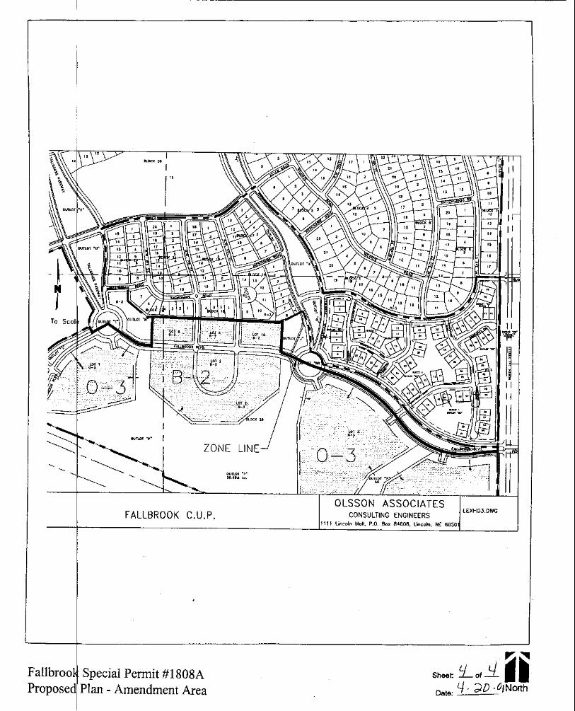
1. To increase lot size and change two single family lots into two single family attachedlots, which creates two additional dwelling units.
2. To waive the requirement of the Design Standards for sidewalks to allow for sidewalkson only one side of the street on Saltgrass Road, Bushclover Road, Snowberry Road,Windflower Road and Windflower Court.
3. To waive Section 26.23.095 that states that sidewalks shall be provided on both sidesof streets. Section 26.27.020 states that as part of the minimum requiredimprovements sidewalks shall be constructed on both sides of the streets within asubdivision.
4. To waive Section 27.15.080 for front, side and rear yard setbacks for main andaccessory buildings in the R-3 district.
GENERAL INFORMATION:
APPLICANT: NEBCO Inc.(Contact Russ McGowan)1815 Y StreetLincoln, NE 68508(402) 434-1212
CONTACT: Gary Bredehoft, Olsson Associates1111 Lincoln MallLincoln, NE 68508(402) 474-6311
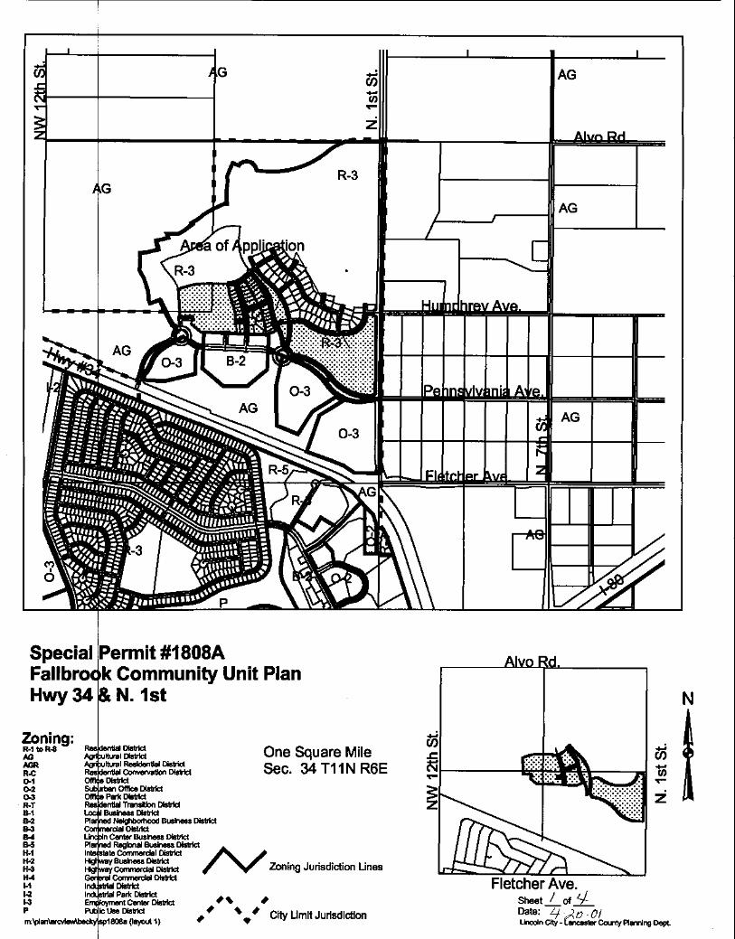
LOCATION: North of Highway 34, south of Alvo Road and west of North 1st Street
Special Permit #1808A Page 2
LEGAL DESCRIPTION: General: Outlots A, B, G, H, I, J, M, O, Q, R, T and V; Lots 1-13,Block 10; Lots 1-9 Block 12; Lots 1 and 2, Block 13; Lots 1-8 and Lots 10-15, Block 11; allof Fallbrook Addition, and a portion of Lot 8 I.T., all located in the South ½ of Section 34,T11N, R6E, Lancaster County, Nebraska, generally located at N. 1st Street and FallbrookBoulevard.
SIZE: 54.44 Acres, more or less.
EXISTING ZONING: R-3
EXISTING LAND USE: Vacant.
SURROUNDING LAND USE AND ZONING: AG Agricultural zoning and agricultural landuses to the north and west; AG zoning and large lot residential uses to the east across North1st Street; to the south across U.S. Highway #34 is the Highlands subdivision with a mix ofapartments, single family and commercial uses in R-3, R-5, B-2 and O-2 zoning.
COMPREHENSIVE PLAN SPECIFICATIONS: In general conformance. Designated asurban residential, urban village and commercial in the Land Use Plan
HISTORY:
Zoned A-A Rural and Public Use District until it was changed during the 1979 update. In 1979the area was zoned AG Agriculture as part of the 1979 update.
In 1999 an application was made to annex the area legally described above to create a NewUrbanist community through a Change of Zone and Special Permit for Community Unit Planprocess. A Use Permit was also required.
On December 1, 1999, Planning Commission recommended conditional approval forFallbrook Special Permit #1808.
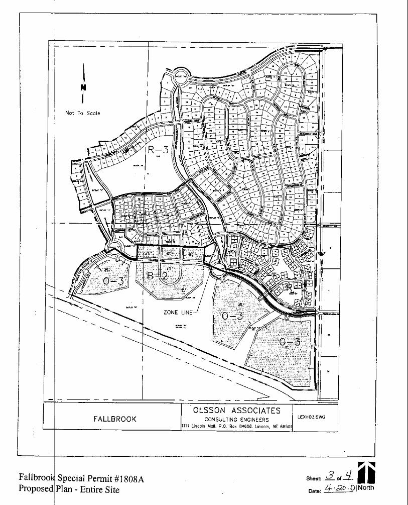
On January 24, 2000, City Council adopted the Fallbrook Special Permit #1808, Use Permit#124 and Preliminary Plat #99023 to allow 314 dwelling units on the property legallydescribed as the above. Front, side and rear yard setbacks were waived by City Council.
On January 24, 2000, City Council adopted Change of Zone #3202 to change the zone fromAG to R-3, O-3 and B-2.
On June 5, 2000, City Council amended Change of Zone #3202 to correct the legaldescription in the R-3 district.
Special Permit #1808A Page 3
On November 29, 2000, the Planning Director approved Administrative Amendment #00069to the Special Permit #1808. The amendment relocated Outlot “D” from Block 17 to Block 16.One lot was removed from Block 17.
Administrative Amendment #01005 to the Special Permit for the Landscape Plan is currentlyunder review. This application amends landscaping material-type only, not the placement ornumber of materials.
SPECIFIC INFORMATION:
UTILITIES: Available.
TOPOGRAPHY: There are no new topography issues with this application.
TRAFFIC ANALYSIS: Sidewalks on only one side of the streets and private roadways willinhibit free-flowing pedestrian movement from the north. Due to the location of Block 1 relativeto the commercial and office areas of the town center, a higher volume of pedestrian traffic isexpected. Reducing the number of sidewalks discourages pedestrian access to thecommercial areas.
There are no new vehicular traffic issues with this proposed amendment. Public streets andprivate roadways are unchanged with this amendment.
PUBLIC SERVICE: The nearest Fire Department is located in the Highlands on N.W. 1st
Street.
ENVIRONMENTAL CONCERNS: There are no new environmental concerns with thisamendment.
ALTERNATIVE USES: To develop the plan with sidewalks on both sides of the streets.
ANALYSIS:
Fallbrook is intended to be a mixed-used “new urbanist” type community. A fundamentalpremise of this type of community is extensive pedestrian orientation. The relationshipbetween the mixed uses in combination with trails encourages pedestrian movement. Toapprove a waiver of sidewalks on one side of the streets would be contrary to the fundamentalpremise of the proposed development and, to some extent, discourage pedestrian movement.The site plan should provide for the space needed for sidewalks on both sides of the streets.Every person who lives in and moves through this development should have full opportunity to
Special Permit #1808A Page 4
use sidewalks for pedestrian movement, and in order to fully achieve this goal sidewalks onboth sides of the streets are necessary.
An increase in the size of some of the lots in Block 1 does not substantially affect the overalldesign goals of the proposed development. Converting two single family lots to duplex dotsin Block 1 does not substantially affect the proposed development.
The requested waivers to front, side and rear yard setbacks helps to achieve some of the newurbanist goals, such as bringing the buildings closer to the street.
STAFF CONCLUSION:
Fallbrook was approved with significant pedestrian orientation. The proposed plan promotesthe development of a more complete neighborhood with stores offices, open space andschools all within walking distance. The approved plans provide an excellent street andpedestrian network that allows for better access and encourages walking throughout the area.Unfortunately the request to waive the requirement that sidewalks be provided on both sidesof the streets will hinder the design goals of the approved development.
Adding two dwelling units is allowable based on previously calculated densities. The additionof these units does not substantially impact the project.
STAFF RECOMMENDATION: Waive setbacks and Change lots: Conditional approvalWaive Sidewalks on one side of the streets: Denial
CONDITIONS:
Site Specific:
1. After the applicant completes the following instructions and submits the documents andplans to the Planning Department office and the plans are found to be acceptable, theapplication will be scheduled on the City Council's agenda:
1.1 Revise the site plan to show:
1.1.1 All references to the Use Permit and Preliminary Plat from the Note Plan(Sheet 2 of 18) are removed.
1.1.2 Waivers listed as a separate title block on the Note Plan (Sheet 2 of 18).
Special Permit #1808A Page 5
1.1.3 Note #3 B of the General Notes to the Special Permit on the Note Plan(Sheet 2 of 18) indicates a minimum distance between the lots and thepublic R.O.W. of 13'.
1.1.4 All changes clearly indicated.
1.1.5 The total # of units indicated in the Community Unit Plan.
1.1.6 Legal Description corrected to show Humphrey Avenue, include OutlotsG and I, spelling error corrected from “o9f” to “of”, Chord Bearing for “S”shown in text and Chord Length of “X” corrected in “Boundary CurveData” to show correct Chord Length.
1.1.7 All dimensions indicated on the Site Plan. Three south dimensions ofthe Community Unit Plan boundary are missing.
1.1.8 The boundary of the Community Unit Plan clearly indicated.
1.1.9 Sidewalks shown on both sides of all public streets and privateroadways.
1.1.10 All landscaping materials shown on the Landscape Plan which are within the boundaries of the Community Unit Plan.
1.1.11 Planning Commission “Approval” certificate removed from the CoverSheet.
1.1.12 City Council approval changed to indicate “Community Unit Plan” ratherthan “Preliminary Plat” on the Cover Sheet.
1.1.13 The blocks and lots renumbered in “Block 1".
1.1.14 Setbacks corrected on the “Single Family Attached” detail and in the textof the Notes.
1.2 Revise the Landscape Plan to show:
1.2.1 Scotch and Ponderosa Pine replaced with Black Hills Spruce, NorwaySpruce, Colorado Spruce and Serbian Spruce.
1.2.2 No more than 10% of any one specie of evergreen.
Special Permit #1808A Page 6
1.2.3 Snowdrift Crab replaced with either “Donald Wyman” or “ProfessorSprenger” Crab.
1.2.4 Street trees on private streets located no closer than 5 feet from backof curb or 5 feet from edge of sidewalk.
1.2.5 Minimum distance between street trees and the foundation oftownhouses is 20 feet.
2. This approval permits 316 dwelling units and variances to front and side yard setbacksas indicated by building envelopes.
General:
3. Before receiving building permits:
3.1 The permittee shall have submitted a revised final plan including 5 copies to thePlanning Department.
3.2 The construction plans shall comply with the approved plans.
3.3 Final Plats shall be approved by the City.
STANDARD CONDITIONS:
4. The following conditions are applicable to all requests:
4.1 Before occupying the dwelling units all development and construction shall havebeen completed in compliance with the approved plans.
4.2 All privately-owned improvements shall be permanently maintained by theowner or an appropriately established homeowners association approved bythe City Attorney.
4.3 The site plan accompanying this permit shall be the basis for all interpretationsof setbacks, yards, locations of buildings, location of parking and circulationelements, and similar matters.
4.4 This resolution's terms, conditions, and requirements bind and obligate thepermittee, its successors and assigns.
Special Permit #1808A Page 7
4.5 The City Clerk shall file a copy of the resolution approving the permit and theletter of acceptance with the Register of Deeds. The Permittee shall pay therecording fee in advance.
5. The site plan as approved with this resolution voids and supersedes all previouslyapproved site plans, however all resolutions approving previous permits remain inforce unless specifically amended by this resolution.
Prepared by:
Becky HornerPlanner
I:\pc\permits\sp1808A.rdh