south asia geography & history chapter test b · 2018-08-06 · name class date south asia...
TRANSCRIPT
Name Class Date
Part 1: Multiple Choice Circle the best answer for each question from the choices available.
1 What is the Ganges Delta?A the place where the Ganges splits
into two partsB the place where the Ganges begins
in the Himalaya MountainsC the place where the Ganges empties
into the Bay of BengalD the place where the Ganges joins
with the Indus River
2 What challenge is faced by people living in the Himalaya Mountains?A no animals or plants to live onB extreme heat and humidityC flooding from living below sea levelD less oxygen in the air
3 Which area receives the least amount of rain from summer or winter monsoons?A Thar Desert B Himalaya Mountains C Deccan PlateauD Sri Lanka
4 What was one result of the Green Revolution for India?A increased its amount of arable landB greatly increased its food productionC started using more solar energyD started a recycling program
5 How does a growing population lead to pollution of the Ganges River?A increased use of industrial chemicalsB more human waste to dispose ofC run-off from fertilizer and pesticidesD water leaking from poisoned wells
6 How does polluted water affect people in South Asia?A Polluted water tastes bad but it
is safe to drink.B Pollution controls make water too
expensive for most people.C Polluted water is unsafe for fish but
does not affect humans.D When water is very polluted it is
unsafe to drink.
7 Which of the following came from the Aryan civilization?A BuddhismB city planningC Sanskrit languageD a system of measurement
8 Which empire practiced Hinduism and made important cultural contributions to India beginning in A.D. 320?A GuptaB HarappanC MauryanD Mughal
9 What mostly Muslim country was known as East Pakistan between 1947 and 1971?A BangladeshB BhutanC NepalD Sri Lanka
10 What religion is associated with the Bhagavad Gita?A BuddhismB ChristianityC HinduismD Islam
South Asia Geography & History
ChApter test B
© NGSP & HB South Asia Geography & History ChApter test B 95
88-99_FA99999_U09C17_1.indd 95 2/14/11 7:47 PM
Name Class Date
Part 2: Interpret Maps Use the map and your knowledge of South Asia to answer the questions below.
80°E70°E60°E 90°E
30°N
20°N
10°N
Tropic of Cancer
Bay of
BengalArabian
Sea
I N D I A N O C E A N
BHUTAN
I N D I A
BANGLADESH
PA K I S TA N
SRI LANKA
N E PA L
Dhaka
Karachi
Delhi
Islamabad
Kolkata(Calcutta)
Bangalore(Bengaluru)
Mumbai(Bombay)
N
S
EW
0 500 Kilometers
0 500 Miles
250
250
0 500 Kilometers
0 500 Miles
250
250
One dot represents100,000 people
Population Density
NGWG_TE_U09_C17_EM_M015FA10 South Asia Population DensityFirst Proof01/26/11
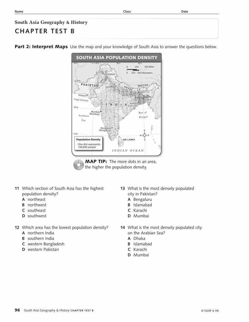
south asIa PoPulatIon densIty
MaP tIP: The more dots in an area, the higher the population density.
11 Which section of South Asia has the highest population density?A northeastB northwestC southeastD southwest
12 Which area has the lowest population density?A northern IndiaB southern IndiaC western BangladeshD western Pakistan
13 What is the most densely populated city in Pakistan?A BengaluruB IslamabadC KarachiD Mumbai
14 What is the most densely populated city on the Arabian Sea?A DhakaB IslamabadC KarachiD Mumbai
South Asia Geography & History
ChApter test B
© NGSP & HB96 South Asia Geography & History ChApter test B
88-99_FA99999_U09C17_1.indd 96 3/15/11 9:53 AM
Name Class Date
Part 3: Interpret Charts Use the chart and your knowledge of South Asia to answer the questions below.
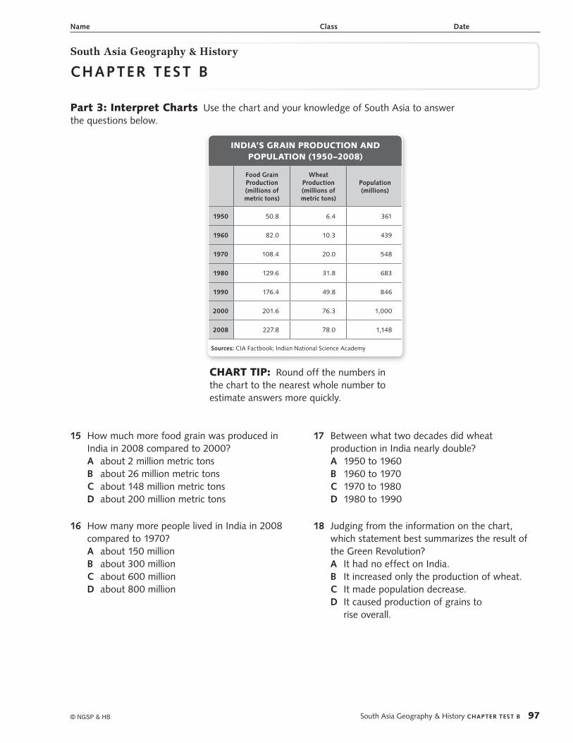
IndIa’s GraIn ProduCtIon and PoPulatIon (1950–2008)
Food Grain Production (millions of metric tons)
Wheat Production (millions of metric tons)
Population (millions)
1950 50.8 6.4 361
1960 82.0 10.3 439
1970 108.4 20.0 548
1980 129.6 31.8 683
1990 176.4 49.8 846
2000 201.6 76.3 1,000
2008 227.8 78.0 1,148
Sources: CIA Factbook; Indian National Science Academy
CHart tIP: Round off the numbers in the chart to the nearest whole number to estimate answers more quickly.
15 How much more food grain was produced in India in 2008 compared to 2000?A about 2 million metric tonsB about 26 million metric tonsC about 148 million metric tonsD about 200 million metric tons
16 How many more people lived in India in 2008 compared to 1970?A about 150 millionB about 300 millionC about 600 millionD about 800 million
17 Between what two decades did wheat production in India nearly double?A 1950 to 1960B 1960 to 1970C 1970 to 1980D 1980 to 1990
18 Judging from the information on the chart, which statement best summarizes the result of the Green Revolution?A It had no effect on India.B It increased only the production of wheat.C It made population decrease.D It caused production of grains to
rise overall.
South Asia Geography & History
ChAPter teSt B
© NGSP & HB South Asia Geography & History ChAPter teSt B 97
88-99_FA99999_U09C17_1.indd 97 2/23/11 11:37 AM
Name Class Date
South Asia Geography & History
Chapter test b
Part 4: Document-Based Question Use the documents and your knowledge of South Asia to answer the questions below.
IntroductionThe British ruled India from 1858 until 1947. Mohandas Gandhi was a leader who helped India become independent. He told Indians to disobey British laws but not to use violence. In July 1947, Great Britain passed the India Independence Act. The act divided India into two separate countries: India and Pakistan, East and West. This is called Partition. East Pakistan became Bangladesh in 1971.
Objective: Explain the Partition of India in 1947.
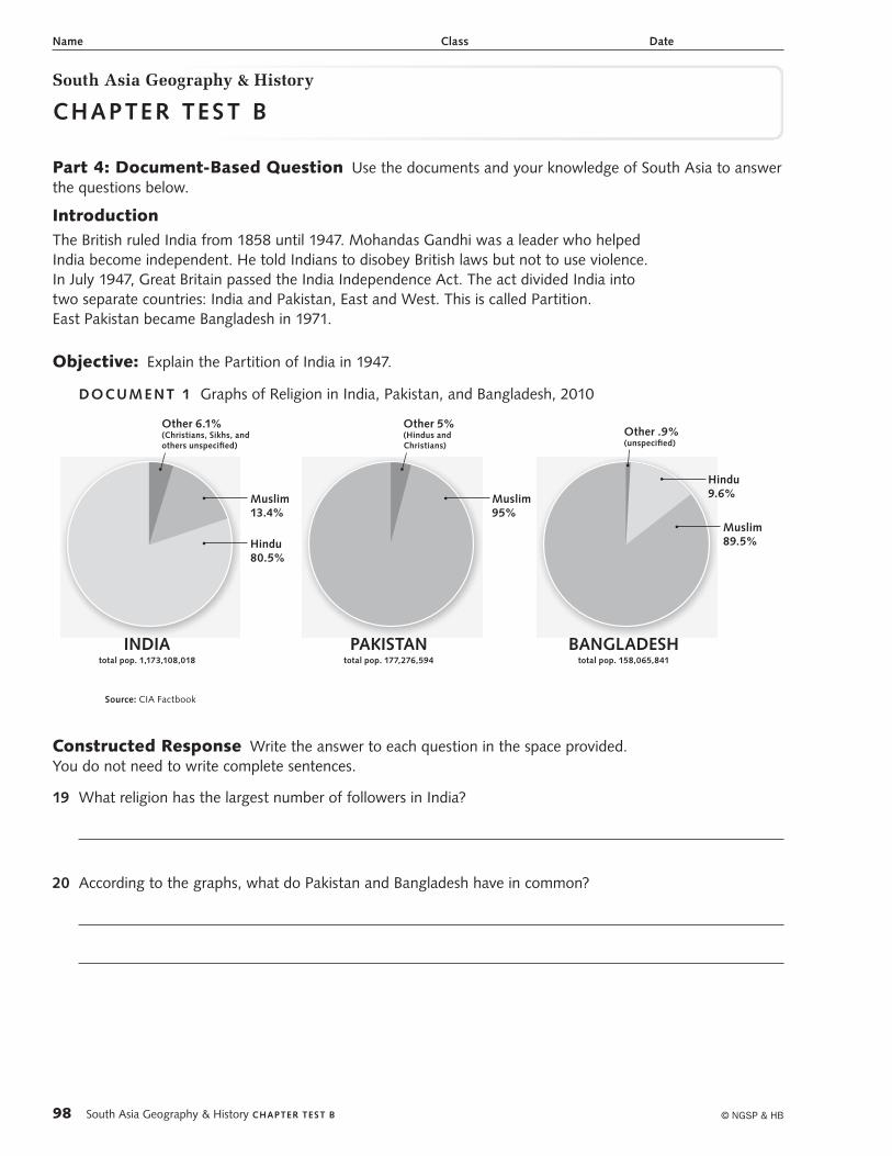
DOCUMe Nt 1 Graphs of Religion in India, Pakistan, and Bangladesh, 2010
INDIAtotal pop. 1,173,108,018
Hindu 80.5%
Muslim 13.4%
Other 6.1% (Christians, Sikhs, and others unspecified)
PAKISTANtotal pop. 177,276,594
Muslim 95%
Other 5% (Hindus and Christians)
BANGLADESHtotal pop. 158,065,841
Muslim 89.5%
Hindu 9.6%
Other .9% (unspecified)
source: CIA Factbook
Constructed Response Write the answer to each question in the space provided. You do not need to write complete sentences.
19 What religion has the largest number of followers in India?
20 According to the graphs, what do Pakistan and Bangladesh have in common?
© NGSP & HB98 South Asia Geography & History Chapter test b
88-99_FA99999_U09C17_1.indd 98 2/23/11 11:38 AM
DOCUME NT 2 Quotation from a prayer by Mohandas Gandhi, January 26, 1948
[Let] us permit ourselves to hope that though geographically and politically India is divided into two, at heart we shall ever be friends and brothers helping and respecting one another and be one for the outside world.
Source: M. K. Gandhi, Delhi Diary, The Essential Gandhi, New York: Random House, 1962
Constructed Response Write the answer to each question in the space provided. You do not need to write complete sentences.
21 What does Gandhi mean when he says “India is divided into two”?
22 How does Gandhi want Hindus and Muslims to act toward one another?
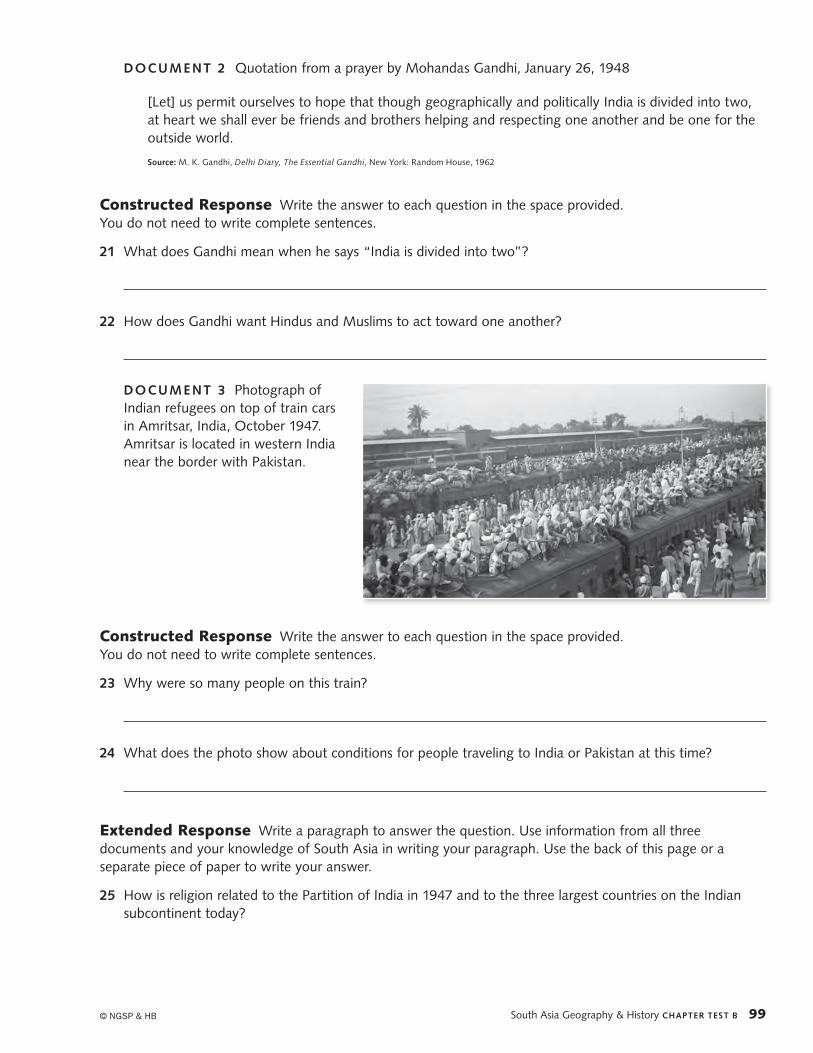
DOCUME NT 3 Photograph of Indian refugees on top of train cars in Amritsar, India, October 1947. Amritsar is located in western India near the border with Pakistan.
Constructed Response Write the answer to each question in the space provided. You do not need to write complete sentences.
23 Why were so many people on this train?
24 What does the photo show about conditions for people traveling to India or Pakistan at this time?
Extended Response Write a paragraph to answer the question. Use information from all three documents and your knowledge of South Asia in writing your paragraph. Use the back of this page or a separate piece of paper to write your answer.
25 How is religion related to the Partition of India in 1947 and to the three largest countries on the Indian subcontinent today?
© NGSP & HB South Asia Geography & History CHAPTER TEST B 99
88-99_FA99999_U09C17_1.indd 99 4/7/11 4:27 PM