some observations made from rov on mid-depth habitats and
TRANSCRIPT
1
Some Observations Made From ROV on Mid-Depth Habitats and
Reef Fish Communities of Saba Bank, Netherlands Antilles
Wes Toller1, Shelley Lundvall
1, and Paul Hoetjes
2
January 25, 2008
1 Saba Conservation Foundation
Saba, Netherlands Antilles
2 Department of Environment & Nature (MINA)
Ministry of Public Health & Social Development (VSO)
Schouwburgweg 26 (APNA building)
Curaçao, Netherlands Antilles
Abstract
A small submersible remotely operated vehicle (ROV) was used to explore mid-depth habitats of
Saba Bank – a submerged carbonate platform in the northeastern Caribbean Sea. The ROV
enabled observation and specimen collection to greater depths (40 to > 150 m) than possible with
conventional scuba methods. The topography, substrate, benthic communities and fish
assemblages of a prominent front reef system at Overall Bank were examined in some detail.
Observations made from ROV indicate that substrate and benthic communities show consistent
zonation patterns along the depth gradient of the front reef slope. A transition in the reef fish
assemblage was also evident, though less pronounced, along this same depth gradient. Fish
diversity (number of species observed per survey) was greatest in the reef crest zone and
declined with depth, however sightings of commercially important lutjanids species such as silk
and blackfin snapper increased with depth. Significant cover by reef-building corals (i.e.
constructional reef development) was only evident in the reef crest zone, and terminated at 38 to
42 m depth. Substrate of the transition slope zone, from 42 m to 75 m depth, was primarily a
hard bottom consisting of consolidated reef structures and rubble with sand interspersed.
Sponges, gorgonians and macro algae dominated the benthic community there. In the deep slope
zone (> 75 m depth), a soft bottom substrate predominated that was composed of fine, readily
resuspended sediments together with scattered rubble fragments. Benthic invertebrates were
very sparse in the deep slope zone. In addition to the surveys at Overall Bank, four ROV surveys
were made at two other Saba Bank areas: Poison Bank and Grapplers Bank. The substrate at
Poison Bank was comprised of coralline algal nodules or “rhodoliths” which formed extensive
rhodoliths beds. At Grapplers Bank, a steep rocky escarpment was explored. The near-vertical
rocky scarp began at 120 m depth and extended down slope beyond the limits of the ROV survey
(157 m depth). Observations made from ROV at Overall Bank suggested a continuous reef
system that is relatively uniform and predictable at mid-depths in terms of its structure, substrate
composition, and community zonation patterns. In contrast, the few observations made by ROV
at Poison Bank and Grapplers Bank revealed habitats that were quite different from those at
Overall Bank. This implies that future ROV explorations to new areas of Saba Bank are likely to
reveal still greater diversity in mid-depth habitat types.
2
Introduction
Saba Bank, Netherlands Antilles, is a large and completely submerged island located in the
northeastern Caribbean Sea. Saba Bank is a flat-topped carbonate platform whose geological
origin sparked some controversy among geologists (Vaughan, 1919, Davis, 1926). Most recent
authors consider Saba Bank to be a submerged coral reef atoll (Van der Land, 1977, Meesters et
al., 1996). To date, two factors have impeded an adequate survey of the marine resources of
Saba Bank - its size and its depth. Saba Bank occupies > 2,200 km2 above the 200 meter isobath
(Meesters et al., 1996), which makes it challenging to sample on an adequate spatial scale. In
addition, much of Saba Bank lies below 40 m depth, thus complicating the use of conventional
scuba diving for surveying, sampling, or direct observation.
Despite the challenges of surveying Saba Bank, many recent studies indicate that the coral reefs
of Saba Bank are - at least potentially - quite large. Percentage bottom cover by scleractinian
corals is reported to be high (Meesters et al., 1996, Klomp and Kooistra, 2003). In addition,
recent surveys of Saba Bank coral reef communities suggest an unanticipated abundance and
diversity of marine organisms in groups such a shallow water reef fishes (RAP Survey Report,
2006, J. Williams, pers. comm.), commercially-harvested fisheries resources (Dilrosun, 2000,
Toller and Lundvall, 2008), crustaceans (Kilgour and Shirley, in prep.), octocorals (Etnoyer et
al., in prep.), and macro algae (M. Littler, pers. comm.). Saba Bank may have the richest
diversity of marine life known from the Caribbean (Conservation International, 2006). Yet these
observations and collections were largely confined to the shallowest habitats of Saba Bank. The
deeper environments of Saba Bank have hardly been explored.
Little is known of coral reefs beyond scuba diving depths, leading some researchers to conclude
that deep reefs “... are a neglected and understudied marine environment” (Bak et al., 2005).
There are a number of compelling reasons to study the deeper reef habitats of Saba Bank. Deep
reef habitats may form refugia from anthropogenic stressors or from natural catastrophic events
such as hurricanes. Such deep reef refugia would serve as important reservoirs for repopulating
degraded coral reef habitats in shallower, near shore areas (e.g. Armstrong et al., 2006). Studies
of deep reef habitats may also support a better informed management of the commercially
important fish species which are harvested from mid-depth habitats of Saba Bank. Additionally,
recent efforts to develop taxonomic inventories for Saba Bank marine communities would
simply be incomplete without exploration of deep reef areas.
Use of submersibles, whether manned (Liddell et al., 1997, Weaver et al., 2006) or unmanned
(Armstrong et al., 2006), allows direct observation of mid-depth or deep reef habitats that lie
beyond the depth limits of conventional scuba diving. This report presents observations made
from a remotely operated vehicle (ROV) on the distribution of physical substrate, benthic
community structure, and species composition of fish assemblages in mid-depth habitats (30 m
to >150 m depth) of Saba Bank. Observations presented here are preliminary and largely
qualitative. However, it is felt that results of this study will encourage more extensive and
quantitative investigations of deep reef habitats of Saba Bank in the future.
3
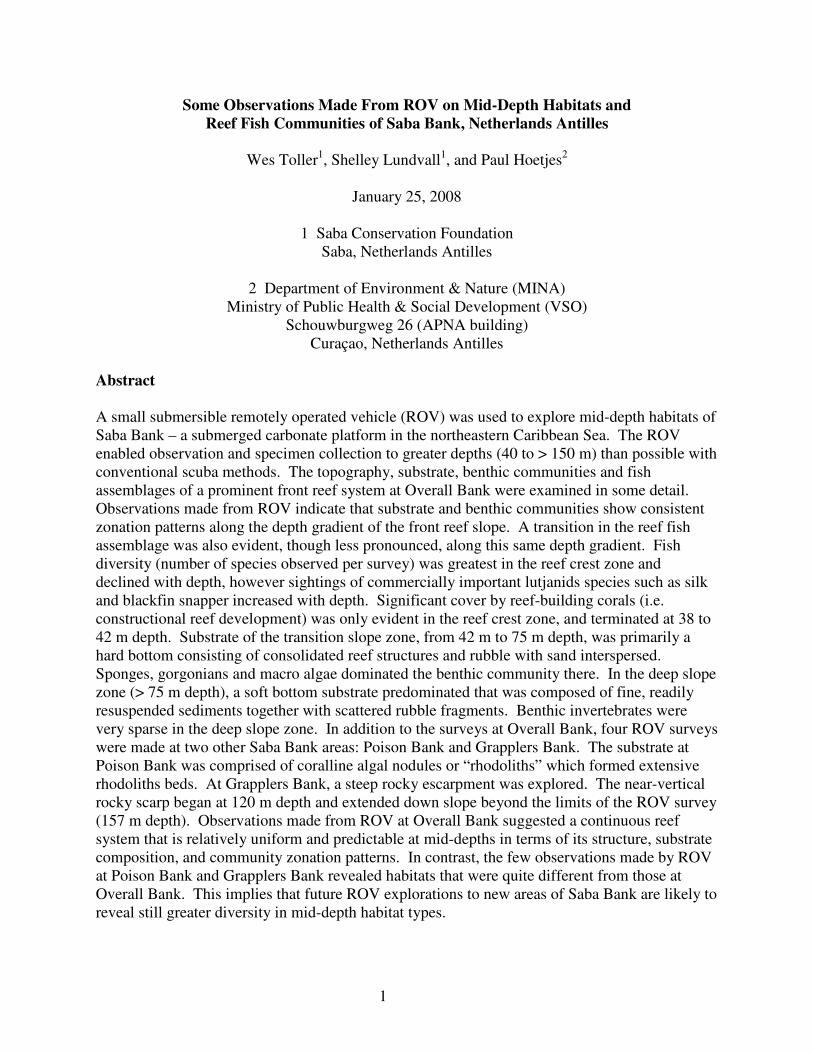
Figure 1. Map of Saba Bank, Saba, Netherlands Antilles, showing ROV survey
sites. Gray polygon shows area enclosed by the 50-m depth contour.
Methods
Study Area:
Saba Bank is located 3-5 km southwest of the Saba Island, Netherlands Antilles, in the northern
Lesser Antilles (Meesters et al., 1996). Saba Bank is a flat-topped structure, approximately 60
km long by 40 km wide (Figure 1). The platform is gently tilted along a southwest to northeast
axis, such that depth increases as one proceeds to the north and west. The shallowest depths and
the most abundant reef structures known to occur on Saba Bank are located along the southern
and eastern margins (Van der Land, 1977). The reef areas on western and northern Saba Bank
have been considered “drowned” reefs (Van der Land, 1977).
In the present study, ROV surveys were targeted to a “front reef” feature (Van der Land, 1977)
located at the shelf-edge (Figure 2) at Overall Bank. The front reef is a zone of rather complex
topography located on eastern Saba Bank. Surveys were designed to complement ongoing
habitat-mapping studies in the adjacent shallow areas of Overall Bank (see Toller, 2008). In
addition to surveys at Overall Bank, limited ROV surveys were conducted at two other areas of
Saba Bank (Figure 1) as described below.
4
ROV:
A small, surface-tended Remotely Operated Vehicle (ROV) - the “Little Benthic Vehicle” or
LBV 200L2 (Seabotix, Inc., San Diego, CA) – was used to explore mid-depth habitats. This
lightweight ROV (200 m depth rating) was selected because it could be deployed from a small
vessel without requirements for specialized shipboard equipment. It was also a comparatively
economical option suitable for work in the remote location of Saba. The pilot operated the ROV
from a shipboard integrated control console with 15-inch color monitor. A floating umbilical
cable (250 m) with optical fiber provided video/command communications between pilot and
ROV. Surface-supplied power (Honda EU2000i gas-powered generator) was delivered via the
umbilical cable.
The ROV was equipped with a primary color video camera (570 line Ex-View HAD, 0.2 Lux
light requirement) and a secondary black & white video camera (430 line resolution, 0.03 Lux
light requirement). Video images were captured on a 73fifty Pelicase Unit digital video recorder
(NETmc Marine, Aberdeenshire, UK) in time-restricted mode. The real-time menu display for
ROV operation was recorded simultaneously and included information for heading (magnetic
compass bearing), depth (m), temp (°C), time, and date. Video files (MPEG format) of five
minute duration (~ 223 Mb per file) were recorded continuously during ROV surveys. Video
files were later transferred to personal computer for review and archiving. The ROV unit was
nicknamed “sharkbait” after the video recorded a close inspection by a tiger shark (Galeocerdo
cuvier) during surface haulback on 6-Nov-07.
Quantification of Observations:
The ROV pilot attempted to make on-the-spot identification of fish species, invertebrates, and
substrate characteristics while conducting surveys. In addition, video recordings were reviewed
post hoc in the lab on a large screen television. Examination of video tapes by independent
viewers allowed for either confirmation or rejection of diagnoses made during initial
observation.
Fish were identified to species where possible and scored for presence/absence in each of the
habitat zone. Scleractinian corals were identified to genus. Most other invertebrates
(gorgonians, sponges, macro algae) were either identified to genus or placed into broad
morphological groupings.
Bathymetry:
In 2006, a detailed multibeam sonar bathymetric survey of Saba Bank was conducted by the
Dutch Hydrographic Service aboard the HNLMS Snellius. With the assistance of Conservation
International, this dataset was assembled as map layers in a geographic information system (GIS)
database (ArcGIS 9.2, ESRI, Inc.). The 2-m resolution bathymetric maps proved to be highly
accurate and were extremely useful for planning survey missions and examining bottom profiles
of mid-depth sites.
Collections:
At a limited number of stations, the ROV was used to collect live benthic specimens (primarily
gorgonian colonies). A Seabotix mechanical “grabber” arm, consisting of three opposing pincer
elements, was fitted to the front of the ROV. Gorgonian specimens were collected by
5
deliberately maneuvering the ROV into position, closing the pincers at the colony base, and then
forcibly rocking/twisting the ROV until the specimen was dislodged.
Results
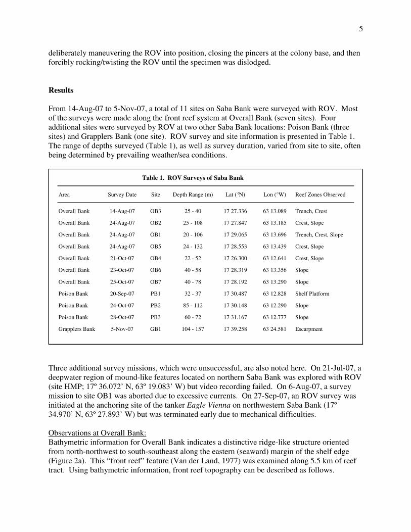
From 14-Aug-07 to 5-Nov-07, a total of 11 sites on Saba Bank were surveyed with ROV. Most
of the surveys were made along the front reef system at Overall Bank (seven sites). Four
additional sites were surveyed by ROV at two other Saba Bank locations: Poison Bank (three
sites) and Grapplers Bank (one site). ROV survey and site information is presented in Table 1.
The range of depths surveyed (Table 1), as well as survey duration, varied from site to site, often
being determined by prevailing weather/sea conditions.
Table 1. ROV Surveys of Saba Bank
Area Survey Date Site Depth Range (m) Lat (°N) Lon (°W) Reef Zones Observed
Overall Bank 14-Aug-07 OB3 25 - 40 17 27.336 63 13.089 Trench, Crest
Overall Bank 24-Aug-07 OB2 25 - 108 17 27.847 63 13.185 Crest, Slope
Overall Bank 24-Aug-07 OB1 20 - 106 17 29.065 63 13.696 Trench, Crest, Slope
Overall Bank 24-Aug-07 OB5 24 - 132 17 28.553 63 13.439 Crest, Slope
Overall Bank 21-Oct-07 OB4 22 - 52 17 26.300 63 12.641 Crest, Slope
Overall Bank 23-Oct-07 OB6 40 - 58 17 28.319 63 13.356 Slope
Overall Bank 25-Oct-07 OB7 40 - 78 17 28.192 63 13.290 Slope
Poison Bank 20-Sep-07 PB1 32 - 37 17 30.487 63 12.828 Shelf Platform
Poison Bank 24-Oct-07 PB2 85 - 112 17 30.148 63 12.290 Slope
Poison Bank 28-Oct-07 PB3 60 - 72 17 31.167 63 12.777 Slope
Grapplers Bank 5-Nov-07 GB1 104 - 157 17 39.258 63 24.581 Escarpment
Three additional survey missions, which were unsuccessful, are also noted here. On 21-Jul-07, a
deepwater region of mound-like features located on northern Saba Bank was explored with ROV
(site HMP; 17º 36.072’ N, 63º 19.083’ W) but video recording failed. On 6-Aug-07, a survey
mission to site OB1 was aborted due to excessive currents. On 27-Sep-07, an ROV survey was
initiated at the anchoring site of the tanker Eagle Vienna on northwestern Saba Bank (17º
34.970’ N, 63º 27.893’ W) but was terminated early due to mechanical difficulties.
Observations at Overall Bank:
Bathymetric information for Overall Bank indicates a distinctive ridge-like structure oriented
from north-northwest to south-southeast along the eastern (seaward) margin of the shelf edge
(Figure 2a). This “front reef” feature (Van der Land, 1977) was examined along 5.5 km of reef
tract. Using bathymetric information, front reef topography can be described as follows.
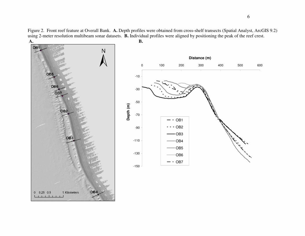
6
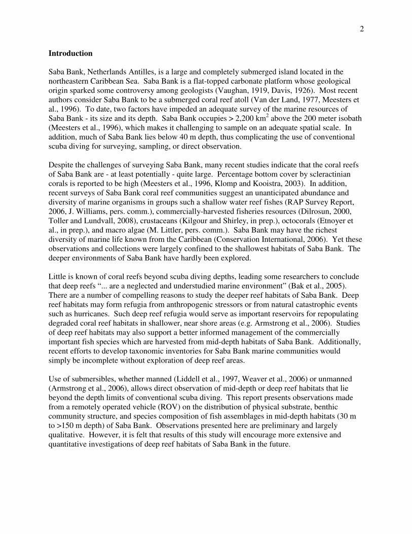
Figure 2. Front reef feature at Overall Bank. A. Depth profiles were obtained from cross-shelf transects (Spatial Analyst, ArcGIS 9.2)
using 2-meter resolution multibeam sonar datasets. B. Individual profiles were aligned by positioning the peak of the reef crest.
A. B.
-150
-130
-110
-90
-70
-50
-30
-10
0 100 200 300 400 500 600
Distance (m)
Dep
th (
m)
OB1
OB2
OB3
OB4
OB5
OB6
OB7
The shallowest depth of the front reef crest (i.e. the summit) is approximately 24 m. This
summit depth was relatively uniform along the axis of the ridge system, averaging 24.2 ± 1.7 (±
st. dev.) and ranging from 22.3 to 26.7 m. Inshore or west of the ridge crest, a “trench” is
present. Trench width (< 40 to > 160 m wide) and depth (32 to > 44 m deep) were highly
variable along the axis of the ridge system (Figure 2a, b). The two ROV surveys that explored
the trench indicated a substrate comprised primarily of sand with some scattered rubble.
Available hard substrate was covered by sponges, gorgonians and macro algae. Although not
quantified, fish diversity and abundance was low within the trench. Fishes observed in the
trench were typical of soft bottom habitats, and included species such as the margate (Haemulon
album), sand tilefish (Malacanthus plumieri), and southern stingray (Dasyatis americana).
Farther inshore (westward) of the front reef crest and trench zone, the reef sloped upward to a
depth of 15 - 20 m. The reef located in this inner zone had a spur & groove morphology. ROV
surveys were not conducted in the inner spur & groove zone because it was surveyed more
effectively using scuba (see Toller, 2008).
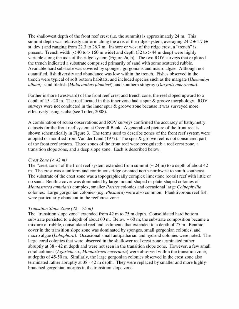
A combination of scuba observations and ROV surveys confirmed the accuracy of bathymetry
datasets for the front reef system at Overall Bank. A generalized picture of the front reef is
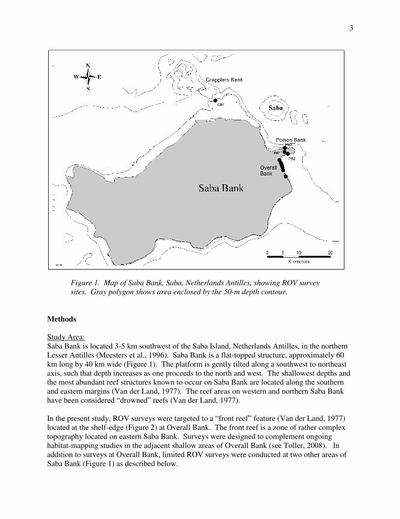
shown schematically in Figure 3. The terms used to describe zones of the front reef system were
adopted or modified from Van der Land (1977). The spur & groove reef is not considered part
of the front reef system. Three zones of the front reef were recognized: a reef crest zone, a
transition slope zone, and a deep slope zone. Each is described below.
Crest Zone (< 42 m)
The “crest zone” of the front reef system extended from summit (~ 24 m) to a depth of about 42
m. The crest was a uniform and continuous ridge oriented north-northwest to south-southeast.
The substrate of the crest zone was a topographically complex limestone (coral) reef with little or
no sand. Benthic cover was dominated by large mound-shaped or plate-shaped colonies of
Montastraea annularis complex, smaller Porites colonies and occasional large Colpophyllia
colonies. Large gorgonian colonies (e.g. Plexaura) were also common. Planktivorous reef fish
were particularly abundant in the reef crest zone.
Transition Slope Zone (42 – 75 m)
The “transition slope zone” extended from 42 m to 75 m depth. Consolidated hard bottom
substrate persisted to a depth of about 60 m. Below ~ 60 m, the substrate composition became a
mixture of rubble, consolidated reef and sediments that extended to a depth of 75 m. Benthic
cover in the transition slope zone was dominated by sponges, small gorgonian colonies, and
macro algae (Lobophora). Occasional small antipatharian and hydroid colonies were noted. The
large coral colonies that were observed in the shallower reef crest zone terminated rather
abruptly at 38 - 42 m depth and were not seen in the transition slope zone. However, a few small
coral colonies (Agaricia sp., Montastraea cavernosa) were observed within the transition zone,
at depths of 45-50 m. Similarly, the large gorgonian colonies observed in the crest zone also
terminated rather abruptly at 38 - 42 m depth. They were replaced by smaller and more highly-
branched gorgonian morphs in the transition slope zone.
8
-110
-100
-90
-80
-70
-60
-50
-40
-30
-20
-10
0
0 100 200 300 400 500 600
Crest Zone
Transition Slope Zone
Deep Slope Zone
Front Reef SystemTrenchSpur &
Groove
Figure 3. Schematic illustration of zones observed at Overall Bank shelf-edge.
Deep Slope Zone (> 75 m)
The “deep slope zone” extended from 75 m to the limits of ROV survey depths (132 m at Overall
Bank). At approximately 75 m depth, a distinct change in slope was generally discernable. The
slope inflexion appeared as a sandy bench extending more gradually down slope. This point
coincided with the deepest extent of consolidated reef and rubble, below which soft bottom
substrate predominated. The depth of the observed inflexion point was corroborated in
bathymetric profiles of survey sites (Figure 2). Sediments in the deep slope zone were very fine
and were easily resuspended by turbulence created by the ROV thrusters. The soft-bottom
substrate of the deep slope zone was largely devoid of benthic invertebrate cover. Small tube
structures (1-2 cm) projected from the sand in some areas. In some areas, meandering tracks
were seen crossing the smooth sediment surface. One set of tracks was followed to a hermit
crab. At OB2, a small rocky outcrop was found and fish were noticeably more abundant near
this structure.
At site OB6, a lost lobster trap was found on the sandy bench at 76 m depth. The trap was
heavily fouled with telestos, sponges and hydroids - an indication that it had been in place for
quite some time. Fortuitously, the vessel captain recognized the trap as his own construction.
He estimated that it was lost about four years ago. Fishes (graysby, rock beauty) were observed
entering and exiting the trap. An attempt was made to recover the lost trap in order to examine
its fouling community, but the trap was firmly lodged into place by sediment accumulation.
Observations at Poison Bank:
Poison Bank or “copper bank” has long been known to the fishermen of Saba. As its name
implies, ciguatera poisoning is commonly associated with fishes taken in this area (Boeke, 1907).
To this day, Saban fishermen rarely fish on Poison Bank (W. Toller, pers. obs.).
9
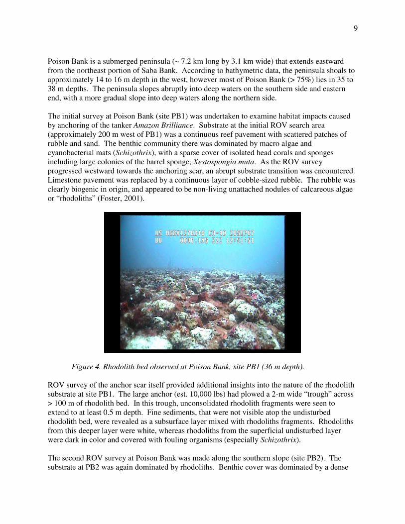
Poison Bank is a submerged peninsula (~ 7.2 km long by 3.1 km wide) that extends eastward
from the northeast portion of Saba Bank. According to bathymetric data, the peninsula shoals to
approximately 14 to 16 m depth in the west, however most of Poison Bank (> 75%) lies in 35 to
38 m depths. The peninsula slopes abruptly into deep waters on the southern side and eastern
end, with a more gradual slope into deep waters along the northern side.
The initial survey at Poison Bank (site PB1) was undertaken to examine habitat impacts caused
by anchoring of the tanker Amazon Brilliance. Substrate at the initial ROV search area
(approximately 200 m west of PB1) was a continuous reef pavement with scattered patches of
rubble and sand. The benthic community there was dominated by macro algae and
cyanobacterial mats (Schizothrix), with a sparse cover of isolated head corals and sponges
including large colonies of the barrel sponge, Xestospongia muta. As the ROV survey
progressed westward towards the anchoring scar, an abrupt substrate transition was encountered.
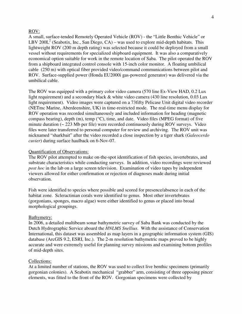
Limestone pavement was replaced by a continuous layer of cobble-sized rubble. The rubble was
clearly biogenic in origin, and appeared to be non-living unattached nodules of calcareous algae
or “rhodoliths” (Foster, 2001).
Figure 4. Rhodolith bed observed at Poison Bank, site PB1 (36 m depth).
ROV survey of the anchor scar itself provided additional insights into the nature of the rhodolith
substrate at site PB1. The large anchor (est. 10,000 lbs) had plowed a 2-m wide “trough” across
> 100 m of rhodolith bed. In this trough, unconsolidated rhodolith fragments were seen to
extend to at least 0.5 m depth. Fine sediments, that were not visible atop the undisturbed
rhodolith bed, were revealed as a subsurface layer mixed with rhodoliths fragments. Rhodoliths
from this deeper layer were white, whereas rhodoliths from the superficial undisturbed layer
were dark in color and covered with fouling organisms (especially Schizothrix).
The second ROV survey at Poison Bank was made along the southern slope (site PB2). The
substrate at PB2 was again dominated by rhodoliths. Benthic cover was dominated by a dense
10
layer of Schizothrix as well as calcareous green algae (Halimeda) and discoidal fleshy brown
algae (Lobophora). Few corals were observed. Large sponges and gorgonians were sparse. The
rhodolith-dominated substrate at PB2 extended to a depth of ~ 87 m. Below this, a more
gradually sloping sand bench extended to a depth of 100 m. Few invertebrates were observed on
this sand bench. At 100 m depth, an abrupt drop off occurred at an exposed rocky scarp. Fish
were comparatively abundant at this drop off. Gorgonians (sea fans and sea whips) were dense
along the scarp as well.
The third ROV survey at Poison Bank was made along the northern slope (site PB3). At PB3,
only a narrow depth range (60 to 72 m) could be surveyed by ROV. Throughout this range, the
substrate was dominated by rhodoliths. Benthic cover was dominated by dense layers of
Schizothrix and macro algae (Lobophora, Halimeda). Sponge and gorgonian cover was sparse.
However there was an abundance of small agariciid colonies (20 - 35 cm diameter) that were
growing atop the rhodoliths bed. Fish species composition was not quantified at PB1 or PB3.
Observations at Grapplers Bank:
The Grapplers Bank is an irregularly-shaped underwater peninsula that extends > 16.5 km to the
northwest from northernmost portion of Saba Bank. It lies between 17.5 and 32 km to the west-
northwest of Saba Island. Recent bathymetric data indicates that Grapplers Bank has an uneven
topography, with shoal areas occurring from 75 to 100 m depth (Figure 1). Average depth is ~
85 m across most of Grapplers Bank. Bathymetry also shows that Grapplers Bank is marked by
numerous precipitous fissures and canyon-like features. The extent of these submarine features,
however, cannot be determined with existing datasets that are limited to < 200 m depth. Only a
single Grapplers Bank site (GB1) could be visited in this study.
Site GB1 was visited on a day of exceptionally calm weather and sea conditions (5-Nov-07). At
the initial point of ROV descent (104 m), the seafloor was a gently sloping soft sediment bottom
with scattered rhodoliths and rubble. As the survey progressed westward, the slope increased
rapidly. A sheer rock escarpment occurred at 120 m depth. This near vertical scarp was
explored to a maximum depth of 157 m. The rocky surface was irregular and punctuated with
ledges and overhangs. Sediments had accumulated on the horizontal surfaces, suggesting
periodic sand flows from above. Scattered gorgonians, sea whips, and sponges lined the wall but
benthic cover by macro invertebrates was generally sparse. Closer inspection of the substrate
indicated a benthic cover of diminutive black corals and hydroids on the rock surface. One
gorgonian colony (colony height ~ 35 cm) was collected at 138.6 m depth from a rock ledge at
GB1. This specimen was sent to P. Etnoyer, Texas A&M University, for identification. Fishes
were not particularly abundant at GB1, and only two species were recorded at this site: blackfin
snapper (L. buccanella) and red hind (E. guttatus).
Fish Observations:
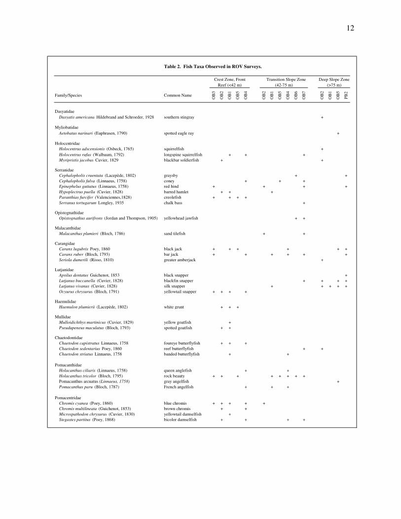
A total of 51 fish species representing 21 families were observed during ROV surveys (Table 2).
When examined by depth zone, observed fish diversity decreased with depth. On average more
species were observed in the reef crest (15.6 ± 5.2 species per survey, range: 8 - 22) than in the
transition zone (6.8 ± 5.5 species per survey, range: 3 - 14) or in the deep slope zone (6.0 ± 3.8
species per survey, range: 1 - 9). The cumulative number of taxa observed was also greater in
the shallow reef crest zone (35 species) than in the transition zone (26 species) or in the deep
11
slope zone (17 species). However, there was substantial overlap in the composition of fishes
observed among zones: 15 taxa co-occurred in reef crest and transition zones, nine taxa co-
occurred in transition slope and deep slope zones.
The most frequently observed fish species were the rock beauty (Holocanthus tricolor), the bar
jack (Caranx ruber), and the black jack (C. lugubris). Some species were observed in all depth
zones, including bar jack, black jack, red hind (Epinephelus guttatus), and great barracuda
(Sphyraena barracuda). Observed taxa that are generally reported from deeper waters included
the silk snapper (L. vivanus), blackfin snapper (L. buccanella) and greater amberjack (Seriola
dumerili). Each of these species was observed only at depths greater than 42 m. In addition, one
adult Caribbean spiny lobster (Panulirus argus) was observed at a depth of 63 m sheltering
beneath a large sponge-encrusted rubble fragment at site OB5.
Fish behavior may have influenced observations to some extent. It was evident that some fish
species were positively attracted to the ROV. Larger predatory species, such as black jack, bar
jack, greater amberjack, and great barracuda, seemed to make deliberate inspections of the ROV
at close range (< 1 m). Ocean triggerfish were also particularly inquisitive. Other fish species
were evidently attracted by disturbances of the substrate caused by the ROV thrusters. This
group included blackfin and silk snappers.
Invertebrate Collections:
In late October of 2007, a multi-national team of scientists joined the project to conduct more
detailed studies on the taxonomic diversity of gorgonians and crustaceans of Saba Bank.
Collections using ROV were instrumental in procuring a number of gorgonian colonies and
crustacean from depths > 40 m. The results from gorgonian studies (Etnoyer et al., in prep.) and
crustacean studies (Kilgour and Shirley, in prep.) will be presented elsewhere.
Limitations of the Methods used:
A number of limitations were identified with the ROV methodology used in this study. These
limitations should be considered carefully in the experimental design of future investigations.
Video-based observation does not provide unequivocal identification to the species level. This
limitation was most evident when dealing with unfamiliar deepwater fauna such as many of the
benthic invertebrates observed below 60 m depth. The accuracy of video-based identification
was further compromised when the organisms 1) were fast moving, 2) were relatively small-
bodied (< 5 cm), and 3) did not allow close approach by ROV. Collection of high quality, color
still photographs may improve the ability to make accurate species diagnoses.
ROV deployment from a small vessel was also not without problems. Despite a depth rating to
200 m, such depths were never realized on the open seas of Saba Bank. A number of factors
contributed to reduced maximum operating depths. Factors included: current, wind, sea surface
state, and length of umbilical cable deployed. In addition, currents and agitated seas acted
synergistically to render the ROV unsteady at depth. The resulting unsteady video images made
it difficult to quantify observations, and in extreme cases, made it impossible to provide positive
taxonomic identifications.
12
Table 2. Fish Taxa Observed in ROV Surveys.
Family/Species Common Name
OB
3
OB
2
OB
1
OB
5
OB
4
OB
2
OB
1
OB
5
OB
4
OB
6
OB
7
OB
2
OB
1
OB
5
PB
2
Dasyatidae
Dasyatis americana Hildebrand and Schroeder, 1928 southern stingray +
Myliobatidae
Aetobatus narinari (Euphrasen, 1790) spotted eagle ray +
Holocentridae
Holocentrus adscensionis (Osbeck, 1765) squirrelfish +
Holocentrus rufus (Walbaum, 1792) longspine squirrelfish + + +
Myripristis jacobus Cuvier, 1829 blackbar soldierfish + +
Serranidae
Cephalopholis cruentata (Lacepède, 1802) graysby + +
Cephalopholis fulva (Linnaeus, 1758) coney + + +
Epinephelus guttatus (Linnaeus, 1758) red hind + + + +
Hypoplectrus puella (Cuvier, 1828) barred hamlet + + +
Paranthias furcifer (Valenciennes,1828) creolefish + + + +
Serranus tortugarum Longley, 1935 chalk bass +
Opistognathidae
Opistognathus aurifrons (Jordan and Thompson, 1905) yellowhead jawfish + +
Malacanthidae
Malacanthus plumieri (Bloch, 1786) sand tilefish + +
Carangidae
Caranx lugubris Poey, 1860 black jack + + + + + +
Caranx ruber (Bloch, 1793) bar jack + + + + + +
Seriola dumerili (Risso, 1810) greater amberjack +
Lutjanidae
Apsilus dentatus Guichenot, 1853 black snapper +
Lutjanus buccanella (Cuvier, 1828) blackfin snapper + + + +
Lutjanus vivanus (Cuvier, 1828) silk snapper + + + + +
Ocyurus chrysurus (Bloch, 1791) yellowtail snapper + + + +
Haemulidae
Haemulon plumierii (Lacepède, 1802) white grunt + + +
Mullidae
Mulloidichthys martinicus (Cuvier, 1829) yellow goatfish +
Pseudupeneus maculatus (Bloch, 1793) spotted goatfish + +
Chaetodontidae
Chaetodon capistratus Linnaeus, 1758 foureye butterflyfish + + +
Chaetodon sedentarius Poey, 1860 reef butterflyfish + +
Chaetodon striatus Linnaeus, 1758 banded butterflyfish + +
Pomacanthidae
Holacanthus ciliaris (Linnaeus, 1758) queen anglefish + +
Holacanthus tricolor (Bloch, 1795) rock beauty + + + + + + + +
Pomacanthus arcuatus (Linnaeus, 1758) gray angelfish +
Pomacanthus paru (Bloch, 1787) French angelfish + + +
Pomacentridae
Chromis cyanea (Poey, 1860) blue chromis + + + + +
Chromis multilineata (Guichenot, 1853) brown chromis + +
Microspathodon chrysurus (Cuvier, 1830) yellowtail damselfish +
Stegastes partitus (Poey, 1868) bicolor damselfish + + + +
Crest Zone, Front
Reef (<42 m)
Transition Slope Zone
(42-75 m)
Deep Slope Zone
(>75 m)
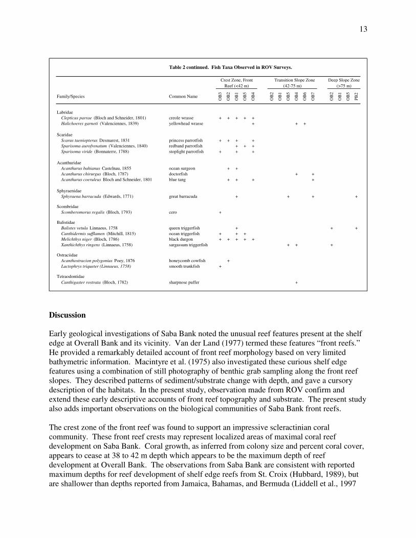
13
Table 2 continued. Fish Taxa Observed in ROV Surveys.
Family/Species Common Name
OB
3
OB
2
OB
1
OB
5
OB
4
OB
2
OB
1
OB
5
OB
4
OB
6
OB
7
OB
2
OB
1
OB
5
PB
2
Labridae
Clepticus parrae (Bloch and Schneider, 1801) creole wrasse + + + + +
Halichoeres garnoti (Valenciennes, 1839) yellowhead wrasse + + +
Scaridae
Scarus taeniopterus Desmarest, 1831 princess parrotfish + + + +
Sparisoma aurofrenatum (Valenciennes, 1840) redband parrotfish + + +
Sparisoma viride (Bonnaterre, 1788) stoplight parrotfish + + +
Acanthuridae
Acanthurus bahianus Castelnau, 1855 ocean surgeon + +
Acanthurus chirurgus (Bloch, 1787) doctorfish + +
Acanthurus coeruleus Bloch and Schneider, 1801 blue tang + + + +
Sphyraenidae
Sphyraena barracuda (Edwards, 1771) great barracuda + + + +
Scombridae
Scomberomorus regalis (Bloch, 1793) cero +
Balistidae
Balistes vetula Linnaeus, 1758 queen triggerfish + + +
Canthidermis sufflamen (Mitchill, 1815) ocean triggerfish + + +
Melichthys niger (Bloch, 1786) black durgon + + + + +
Xanthichthys ringens (Linnaeus, 1758) sargassum triggerfish + + +
Ostraciidae
Acanthostracion polygonius Poey, 1876 honeycomb cowfish +
Lactophrys triqueter (Linnaeus, 1758) smooth trunkfish +
Tetraodontidae
Canthigaster rostrata (Bloch, 1782) sharpnose puffer +
Crest Zone, Front
Reef (<42 m)
Transition Slope Zone
(42-75 m)
Deep Slope Zone
(>75 m)
Discussion
Early geological investigations of Saba Bank noted the unusual reef features present at the shelf
edge at Overall Bank and its vicinity. Van der Land (1977) termed these features “front reefs.”
He provided a remarkably detailed account of front reef morphology based on very limited
bathymetric information. Macintyre et al. (1975) also investigated these curious shelf edge
features using a combination of still photography of benthic grab sampling along the front reef
slopes. They described patterns of sediment/substrate change with depth, and gave a cursory
description of the habitats. In the present study, observation made from ROV confirm and
extend these early descriptive accounts of front reef topography and substrate. The present study
also adds important observations on the biological communities of Saba Bank front reefs.
The crest zone of the front reef was found to support an impressive scleractinian coral
community. These front reef crests may represent localized areas of maximal coral reef
development on Saba Bank. Coral growth, as inferred from colony size and percent coral cover,
appears to cease at 38 to 42 m depth which appears to be the maximum depth of reef
development at Overall Bank. The observations from Saba Bank are consistent with reported
maximum depths for reef development of shelf edge reefs from St. Croix (Hubbard, 1989), but
are shallower than depths reported from Jamaica, Bahamas, and Bermuda (Liddell et al., 1997
14
and references therein) where reef development occurs to depths > 60 m. It should also be noted
that at Poison Bank, plating agariciids were observed at considerably greater depths (> 60 m)
than at Overall Bank. Thus, it is also possible that maximum depth of reef development varies as
a function of the specific location on Saba Bank.
The discovery of extensive rhodolith beds on Poison Bank is novel, and represents a new “class”
of mid-depth habitat on Saba Bank. Foster (2001) suggested that rhodoliths beds may be one of
the world’s most ecologically significant habitat types. The extent of such rhodoliths beds on
Saba Bank is unknown at present. If initial indications from Poison Bank are substantiated, then
the extent of rhodolith beds there (as much as 17 km2) may be substantial. It is important to
consider that only a trivial portion of Saba Bank mid-depth habitats have been surveyed.
Forthcoming side scan sonar datasets should be useful for identifying rhodolith beds and
quantifying their spatial extent.
Isolated carbonate platforms or “banks” such as the Pedro Bank of Jamaica (Aiken and Kong,
2000) may support valuable commercial fisheries. Despite their economic importance to
regional Caribbean fisheries, the habitats of such banks, as well as the processes controlling reef
development on them, remain poorly known (Hallock and Elrod, 1998). Saba Bank is no
exception. Commercial finfish harvests from Saba Bank are dominated by silk snapper, Lutjanus
vivanus, and blackfin snapper, L. buccanella, captured with trap or hook & line from mid-depths
(Dilrosun, 2000, Toller and Lundvall, 2008). Effective management of these finfish resources
requires a more detailed understanding of specific fish-habitat associations and knowledge of
habitat distribution.
In conclusion, the results from this study give an initial glimpse of mid-depth habitats of Saba
Bank. Additional studies are clearly needed. Future work should focus on acquiring quantitative
estimates of fish and benthic invertebrate abundance. The sampling design of future Saba Bank
mid-depth habitat studies will be greatly facilitated by existing and forthcoming remote sensing
mapping products for Saba Bank (i.e. multibeam sonar, sidescan sonar). Conversely, ROV
studies may provide critical ground-truth observations to facilitate accurate mapping of the
distribution of habitats across Saba Bank.
Acknowledgments
Many individuals contributed to the success of our ROV surveys. We wish to thank Nicholas
Johnson (captain, F/V Jackie Jane) and Sue Hurrell (Saba National Marine Park). Participating
project scientists each added to the surveys. We extend our thanks to Tom Shirley, Morgan
Kilgour, and Peter Etnoyer (Texas A&M University), Herman Wirshing (University of Miami)
and Juan Armando Sanchez (University of Colombian). Shelley and Norman Maruri Robertson
of Seabotix, Inc., provided training in ROV operations and maintenance. Jan den Dulk, manager
of Saba National Marine Park, provided office space and logistical support to The Saba Bank
Project. This work was part of the implementation of the Nature and Environment Policy Plan
(NEPP) of the department of Environment & Nature of the Netherlands Antilles, funded by
Dutch development support administered provided through the Development Foundation of the
15
Netherlands Antilles (USONA) and carried out with the help of the Saba Conservation
Foundation, Saba, Netherlands Antilles.
References
Aiken, K., and G. A. Kong (2000) The marine fisheries of Jamaica. NAGA, The ICLARM
Quarterly, 23(1):29-35.
Armstrong, R. A., H. Singh, J. Torres, R. S. Nemeth, A. Can, R. Eustice, L. Riggs, and G.
Garcia-Moliner (2006) Characterizing the deep insular shelf coral reef habitat of the Hind
Bank marine conservation district (US Virgin Islands) using the Seabed autonomous
underwater vehicle. Continental Shelf Research 26:194-205.
Bak, R. P. M., G. Nieuwland, and E. H. Meesters (2005) Coral reef crisis in deep and shallow
reefs: 30 years of constancy and change in reefs of Curacao and Bonaire. Coral Reefs
24:475-479.
Boeke, J. (1907) Rapport betreffende een voorloopig onderzoek naar den toestand van de visserij
en de industrie van zeeproducten in de kolonie Curacao. Eerste gedeelte, [iv] + 200 pp.
Conservation International (2006) Expedition discovers marine treasures. Biological
Conservation Newsletter. Plant Conservation Unit, Department of Botany, Smithsonian
National Museum of Natural History No. 255, March 2006.
Davis, W. M. (1926) The Lesser Antilles. American Geological Society Publication 2, 207 pp.
Dilrosun, F. (2000) Monitoring the Saba Bank fishery. Department of Public Health and
Environmental Hygiene, Environmental Division. Curacao, Netherlands Antilles. 56 pp.
Etnoyer, P., H. Wirshing, and J. A. Sanchez (in prep.) Shallow and deep-water gorgonian
surveys on Saba Bank, Netherlands Antilles. Abstract. Eleventh International Coral Reef
Symposium, Ft. Lauderdale, Florida, 2008.
Foster, M. S. (2001) Rhodoliths: Between rocks and soft places. Journal of Phycology 37:659-
667.
Hallock P., and J. A. Elrod (1998) Oceanic chlorophyll around carbonate platforms in the
Western Caribbean; observations from CZCS data. Proceedings of the Sixth International
Coral Reef Symposium, Australia. Vol. 2:449-454.
Hubbard, D. (1989) The shelf-edge reefs of Davis and Cane Bays, Northwestern St. Croix,
U.S.V.I. 12th
Caribbean Geological Conference, 167-179. Teague Bay, St. Croix: West
Indies Laboratory.
16
Kilgour, M., and T. C. Shirley (in prep.) Crustaceans of Saba Bank, Netherlands Antilles.
Abstract. Eleventh International Coral Reef Symposium, Ft. Lauderdale, Florida, 2008.
Klomp, K. D., and D. J. Kooistra (2003) A post-hurricane, rapid assessment of reefs in the
windward Netherlands Antilles (stony corals, algae and fishes). Pp. 404-437, in: J.C. Lang
(Ed.) Status of Coral Reefs in the Western Atlantic: Results of Initial Surveys, Atlantic and
Gulf Rapid Reef Assessment (AGRRA) Program. Atoll Research Bulletin 496.
Liddell, W. D., W. E. Avery, and S. L. Ohlhorst (1997) Patterns of benthic community structure,
10-250 m, The Bahamas. Proceedings of the Eighth International Coral Reef Symposium,
Panama. Vol. 1:437-442.
Macintyre, I. G., D. J. J. Kinsman, and R. C. German (1975) Geological reconnaissance survey
of Saba Bank, Caribbean Sea. Caribbean Journal of Science 15(1-2):11-20.
Meesters, E. H., H. Nijkamp, and L. Bijvoet (1996) Towards sustainable management of the
Saba Bank. A report for the Department of Public Health and Environment (VOMIL),
Curacao, Netherlands Antilles. AIDEnvironment, Amsterdam, The Netherlands. 58 pp.
RAP Survey Report (2006) Preliminary Report: Marine RAP Survey of Saba Bank, Saba Island,
Netherlands Antilles, Caribbean. January 4 to 15, 2006. 9 pp.
Toller, W. (2008) Habitat surveys of Saba Bank, Netherlands Antilles: An assessment of benthic
communities and fish assemblages. Saba Conservation Foundation, Saba, Netherlands
Antilles. 52 pp.
Toller, W., and S. Lundvall (2008) Assessment of the commercial fishery of Saba Bank.. Saba
Conservation Foundation, Saba, Netherlands Antilles. 56 pp.
Van der Land, J. (1977) The Saba Bank – A large atoll in the northeastern Caribbean. FAO
Fisheries Report No. 200, 469-481.
Vaughan, T. W. (1919) Fossil corals from Central America, Cuba, and Puerto Rico, with an
account of the American Tertiary, Pleistocene, and recent coral reefs. Smithsonian Institution
U.S. National Museum Bulletin 103.
Weaver, D. C., E. L. Hickerson, and G. P. Schmahl (2006) Deep reef fish surveys by
submersible on Alderdice, McGrail, and Sonnier Banks in the Northwestern Gulf of Mexico.
Professional Paper NMFS 5, National Marine Fisheries Service, pp. 69-87.