sinkholes 2
TRANSCRIPT

Sinkholes are a fact of life in Florida. They occur because the entire state of Florida is underlain by limestone, a type of rock that is slowly dissolved by weak natural acids found in rain and in the pore spaces in soil.
Sinkholes become more of a problem in areas where sediments that lie above the limestone are mainly clays mixed with sand. Clay causes these sediments, which also range in thickness from 30 to 200 feet, to be cohesive. They are not very permeable to water. In these areas sinkholes are most numerous. They vary in size and may form suddenly. In a few areas of Florida over 200 feet of sediments cover the underlying limestone. These sediments are cohesive because of the clay and layers of limestone they contain. Although there are not many sinkholes in these areas, the ones that occur are deep and wide. These types of sinkholes are referred to as “cover-collapse sinkholes” because cohesive layers of sediment collapse into underground cavities when they form.
The abrupt formation of sinkholes may follow extreme rain producing events such as tropical storms or hurricanes. This is because the weight of a large amount of rain water at the earth’s surface may bring about the collapse of an underground cavity if its limestone “ceiling” has become thin. This tendency for sinkholes to form following events that produce large amounts of rainfall is made worse in times of drought. During periods of drought underground cavities that might normally be filled with water may be only partially filled. These cavities are less likely to bear the weight of flood waters without collapsing.
Sinkholes are part of Florida’s natural environment. Surface water flows through sinkholes into the underlying limestone layers of the Floridan aquifer system, the major source of drinking water in Florida. Because they provide a direct connection from the surface to the aquifer system, it is very important to protect sinkholes from pollution. This may be as simple as making sure that sinkholes do not become convenient sites for dumping. The use of conservation buffers (strips of land maintained in permanent vegetation) around sinkholes can help protect groundwater from fertilizers and pesticides that might otherwise enter sinkholes on farm lands. The use of fencing around sinkholes may help protect groundwater from animal waste.
http://www.youtube.com/results?search_query=Mahfuz+haq
http://www.youtube.com/watch?v=N-sU_Rwbmaw
Mahfuz Haq …..

SinkholeFrom Wikipedia, the free encyclopedia
(Redirected from Sinkholes)
For the War of 1812 battle, see Battle of the Sink Hole. For a hole in a sink, see Drain (plumbing).
A sink hole in Oman

The Devil's Hole sinkhole nearHawthorne, Florida, USA.
A sinkhole, also known as a sink, snake hole, swallow hole, swallet, doline, orcenote, is a natural
depression or hole in the Earth's surface caused by karst processes — the chemical dissolution of carbonate
rocks[1] or suffosion processes[2] for example insandstone. Sinkholes may vary in size from 1 to 600 meters (3.3
to 2,000 ft) both in diameter and depth, and vary in form from soil-lined bowls to bedrock-edged chasms.
Sinkholes may be formed gradually or suddenly, and are found worldwide. The different terms for sinkholes are
often used interchangeably.[3]
Contents
[hide]
1 Formation mechanisms
2 Occurrence
3 Local names of sinkholes
4 Piping pseudokarst
5 Notable sinkholes
6 See also
7 References
8 External links
[edit]Formation mechanisms

Sinkholes near the Dead Sea, formed by dissolution of underground salt by incoming freshwater, as a result of a continuing sea level drop.
A special type of sinkhole – formed by rainwater leaking through the pavement and carrying dirt into a ruptured sewer pipe.
Sinkholes may capture surface drainage from running or standing water, but may also form in high and dry
places in a certain location.
The mechanisms of formation involve natural processes of erosion[4] or gradual removal of slightly soluble
bedrock (such as limestone) by percolating water, the collapse of a cave roof, or a lowering of the water table.
Sinkholes often form through the process of suffosion. Thus, for example, groundwater may dissolve the
carbonate cement holding the sandstone particles together and then carry away the lax particles, gradually
forming a void.
Occasionally a sinkhole may exhibit a visible opening into a cave below. In the case of exceptionally large
sinkholes, such as Minyé sinkhole in Papua New Guinea or Cedar Sink at Mammoth Cave National Park, USA,
a stream or river may be visible across its bottom flowing from one side to the other.
Sinkholes are common where the rock below the land surface is limestone or othercarbonate rock, salt beds, or
rocks that can naturally be dissolved by circulating ground water. As the rock dissolves, spaces and caverns
develop underground. These sinkholes can be dramatic because the surface land usually stays intact until
there is not enough support. Then, a sudden collapse of the land surface can occur.

Sinkholes also form from human activity, such as the rare but still occasional collapse of abandoned mines in
places like West Virginia, USA. More commonly, sinkholes occur inurban areas due to water main breaks
or sewer collapses when old pipes give way. They can also occur from the overpumping and extraction of
groundwater and subsurface fluids. They can also form when natural water-drainage patterns are changed and
new water-diversion systems are developed. Some sinkholes form when the land surface is changed, such as
when industrial and runoff-storage ponds are created; the substantial weight of the new material can trigger an
underground collapse of supporting material, thus, causing a sinkhole.
[edit]Occurrence
Sinkholes are usually but not always linked with karst landscapes. In such regions, there may be hundreds or
even thousands of sinkholes in a small area so that the surface as seen from the air looks pock-marked, and
there are no surface streams because all drainage occurs sub-surface. Examples of karst landscapes dotted
with numerous enormous sinkholes are Khammouan Mountains (Laos) and Mamo Plateau (Papua New
Guinea).[5] The largest known sinkholes formed in sandstone are Sima Humboldt and Sima
Martel in Venezuela.[5]
The most impressive sinkholes form in thick layers of homogenous limestone. Their formation is facilitated by
high groundwater flow, often caused by high rainfall – such high rainfall causes formation of the giant sinkholes
in Nakanaï Mountains, New Britain island in Papua New Guinea.[6] On the contact of limestone and insoluble
rock below it there form powerful underground rivers which may create large underground voids.
In such conditions have formed the largest known sinkholes of the world, like the 662-metre (2,172 ft) deep
Xiaozhai tiankeng (Chongqing, China), giant sótanos in Querétaro and San Luis Potosí states in Mexico and
others.[5][7][8]
Unusual processes have formed the enormous sinkholes of Sistema Zacatón in Tamaulipas (Mexico) – here
more than 20 sinkholes and other karst formations have been shaped by volcanically heated, acidic
groundwater.[9][10] This has secured not only the formation of the deepest water-filled sinkhole in the world
– Zacatón, but also unique processes of travertine sedimentation in upper parts of sinkholes, leading to sealing
of these sinkholes with travertine lids.[citation needed]
The state of Florida in the USA is known for having frequent sinkholes, especially in the central part of the
state. The Murge area in southern Italy also has numerous sinkholes. Sinkholes can be formed in retention
ponds from large amounts of rain.[citation needed]

The Great Blue Hole, located nearAmbergris Caye, Belize.
Sinkholes have been used for centuries as disposal sites for various forms of waste. A consequence of this is
the pollution of groundwater resources, with serious healthimplications in such areas. In contrast, the Maya
civilization sometimes used sinkholes in the Yucatán Peninsula (known as cenotes) as places to deposit
precious items and sacrifices.[citation needed]
Many sinkholes are found in Northern Michigan. These are prominent in Alpena County in Northeast Michigan.
In Lachine, Michigan there are five sinkholes that are found to be very deep and within 2 miles (3.2 km) from
each other. Alpena's visitor information cites their sinkholes as an attraction for visitors to the area. In August
1998 a 16 year old Alpena boy survived a 200 feet (61 m)+ fall in an open sinkhole .75 miles (1.2 km) from
Leer road inLachine, Michigan.[11] A majority of sinkholes in Alpena are also found underwater. Many divers
explore these on a regular basis.[citation needed]
When sinkholes are very deep or connected to caves, they may offer challenges for experienced cavers or,
when water-filled, divers. Some of the most spectacular are the Zacatón cenote in Mexico (the world's deepest
water-filled sinkhole), the Boesmansgat sinkhole in South Africa, Sarisariñama tepuy in Venezuela, and in the
town of Mount Gambier, South Australia. Sinkholes that form in coral reefs and islands that collapse to
enormous depths are known as Blue Holes, and often become popular diving spots.[citation needed]

Image of the entire surface water flow of the Alapaha River near Jennings, Floridagoing into a sinkhole leading to the Floridan Aquifer groundwater.
The overburden sediments that cover buried cavities in the aquifer systems are delicately balanced
by groundwater fluid pressure. The water below ground is actually helping to keep the surface soil in place.
Groundwater pumping for urban water supply and for irrigation can produce new sinkholes in sinkhole-prone
areas. If pumping results in a lowering of groundwater levels, then underground structural failure, and thus
sinkholes, can occur.[citation needed]
[edit]Local names of sinkholes
Large and visually unusual sinkholes have been well known to local people since ancient times. Also nowadays
sinkholes are grouped and named in site specific or generic names. Some examples of such names are:[12]
cenotes. Characteristic water filled sinkholes in Yucatán Peninsula, Belize and some other regions. Many
cenotes have formed in limestone which deposited in shallow seas created by Chicxulub meteorite impact.
tiankengs. These are extremely large sinkholes which are deeper and wider than 100 m, with mostly
vertical walls, most often created by the collapse of underground caverns. This term is proposed by
Chinese geologists as many of the largest sinkholes are located in China. The largest tiankeng is the 662
m deep Xiaozhai tiankeng, which is also the largest known sinkhole of the world.
sótanos. This name is given to several giant pits in several states of Mexico. The best known is the 372 m
deep Sótano de las Golondrinas – Cave of Swallows.
blue holes. This name initially has been given to the deep underwater sinkholes of Bahamas but often is
used for any deep water-filled pits formed in carbonate rocks. Name originates from the deep blue color of
water in these sinkholes, which in turn is created by the high lucidity of water and the large depth of
sinkholes – only the deep blue color of the visible spectrum can penetrate such depth and after reflection
return back. The deepest known undersea sinkhole is Dean's Blue Hole in Bahamas.
black holes. Group of unique round, water filled pits in Bahamas. These formations seem to be dissolved
in carbonate mud from above, by the sea water. Dark color of water is caused by the layer of phototropic
microorganisms concentrated in dense, purple colored layer in 15 – 20 metre depth – this layer "swallows"
the light. Metabolism in the layer of microorganisms causes heating of water – the only known case in
natural world where microorganisms create significant thermal effects. Most impressive is Black Hole of
Andros.[13]
tomo used in New Zealand karst country to describe pot holes.
[edit]Piping pseudokarst
What has been called a "sinkhole" by the popular press formed suddenly in Guatemala in May 2010. Torrential
rains from Tropical Storm Agatha and a bad drainage system were blamed for creating the 2010 "sinkhole" that
swallowed a three story building and a house.[14] This large vertical hole measured approximately 66 feet (20 m)
wide and 100 feet (30 m) deep. A similar hole had formed nearby in February 2007.[15][16]
This large vertical hole, called a "sinkhole" in the popular press, is not a true sinkhole as it did not form via the
dissolution either of limestone, dolomite, marble, or any other carbonate rock.[17][18] Guatemala City is not
underlain by any carbonate rock; instead, thick deposits of volcanic ash, unwelded ash flow tuffs, and
other pyroclastic debris underlie all of Guatemala City. Thus, it is impossible for the dissolution of carbonate
rock to have formed the large vertical holes that swallowed up parts of Guatemala City in 2007 and 2010.[17]
The large holes that swallowed up parts of Guatemala City in 2007 and 2010 are a spectacular example of
"piping pseudokarst", created by the collapse of large cavities that had developed in the weak, crumbly
Quaternary volcanic deposits underlying the city. Although weak and crumbly, these volcanic deposits have
enough cohesion to allow them to stand in vertical faces and develop large subterranean voids within them. A
process called "soil piping" first created large underground voids as water from leaking water mains flowed
through these volcanic deposits and washed fine volcanic materials out of them, then progressively eroded and
removed coarser materials. Eventually, these underground voids became large enough that their roofs
collapsed to create large holes.[17]
[edit]Notable sinkholes
Some of the largest and most impressive sinkholes in the world are:[5]
Xiaozhai tiankeng – Chongqing Municipality, China. Double nested sinkhole with vertical walls, 662 m
deep.
Dashiwei tiankeng – Guangxi, China. 613 m deep, with vertical walls, bottom contains isolated patch of
forest with rare species.
Red Lake – Croatia. Approximately 530 m deep pit with nearly vertical walls, contains approximately 280 –
290 m deep lake.
Minyé sinkhole – East New Britain, Papua New Guinea. 510 m deep, with vertical walls, crossed by
powerful stream.
Sótano del Barro – Querétaro, Mexico. 410 m deep, with nearly vertical walls.
Cave of Swallows – San Luis Potosí, Mexico. 372 m deep, round sinkhole with overhanging walls.
Sima de las Cotorras - Chiapas, Mexico. 160 m across, 140 m deep, with thousands of green
parakeets and ancient rock paintings.
Zacatón – Tamaulipas, Mexico. Deepest water-filled sinkhole in world, 339 m deep.
Floating travertine islands.
Sima Humboldt – Venezuela. Largest sinkhole in sandstone, 314 m deep, with vertical walls. Unique,
isolated forest on bottom.

Teiq sinkhole – Oman. One of the largest sinkholes in the world by volume – 90 million cubic metres.
Several perennial wadis fall with spectacular waterfalls into this 250 m deep sinkhole.
Dean's Blue Hole – Bahamas. Deepest known sinkhole under the sea, depth 203 m. Popular location for
world championships offree diving.
Blue Hole – Dahab, Egypt. A round sinkhole or blue hole, 130m deep. Includes an extraordinary archway
leading out to the Red Sea at 60m, renowned for freediving and scuba attempts, the latter often fatal. Also
see Bell's to Blue Hole drift dive.
Great Blue Hole – Belize. Spectacular, round sinkhole, 124 m deep. Unusual features are tilted stalactites
in great depth, which mark the former orientation of limestone layers when this sinkhole was above the
water level.
Kingsley Lake – Florida, USA. 2,000 acres (8.1 km2) in area, 90 ft (27 m) deep and almost perfectly round.
Gypsum Sinkhole – Utah, USA. Nearly 50 ft (15 m) in diameter and approximately 200 ft (61 m) deep.
Harwood Hole - Abel Tasman National Park, New Zealand, 183 m deep
Bimmah Sinkhole - Wadi Shab and Wadi Tiwi, Oman, 80 m deep
Florida
From Wikipedia, the free encyclopedia
This article is about the U.S. state of Florida. For other uses, see Florida (disambiguation).
State of Florida
Flag Seal

Nickname(s): The Sunshine State
Motto(s): In God We Trust
State anthem: Florida, Where the Sawgrass Meets the Sky
Official language(s) English [1]
Spoken language(s) English 74.5%
Spanish 18.7%[2]
Demonym Floridian
Capital Tallahassee
Largest city Jacksonville
Largest metro area Miami metropolitan area
Area Ranked 22nd in the U.S.
- Total 65,755[3] sq mi
(170,304[3] km2)
- Width 361 miles (582 km)
- Length 447 miles (721 km)
- % water 17.9
- Latitude 24° 27′ N to 31° 00' N

- Longitude 80° 02′ W to 87° 38′ W
Population Ranked 4th in the U.S.
- Total 19,057,542 (2011 est)[3]
- Density 353.4/sq mi (136.4/km2)
Ranked 8th in the U.S.
Elevation
- Highest point Britton Hill [4] [5]
345 ft (105 m)
- Mean 100 ft (30 m)
- Lowest point Atlantic Ocean[4]
sea level
Before statehood Florida Territory
Admission to Union March 3, 1845 (27th)
Governor Rick Scott (R)
Lieutenant Governor Jennifer Carroll (R)
Legislature Florida Legislature
- Upper house Senate
- Lower house House of Representatives
U.S. Senators Bill Nelson (D)
Marco Rubio (R)
U.S. House delegation 19 Republicans, 6 Democrats (list)
Time zones

- Peninsula and "Big Bend" region Eastern: UTC -5/-4
- Panhandle west of theApalachicola River Central: UTC -6/-5
Abbreviations FL Fla. US-FL
Website www.myflorida.com
[show]
Florida State symbols
Map of Florida's incorporated municipalities
Florida ( i / ̍ f l ɒr ɪ d ə / ) is a state in the southeastern region of the United States, bordered to the west by the Gulf of Mexico, to the north
by Alabama and Georgia and to the east by the Atlantic Ocean. Florida is the 22nd most extensive, the 4th most populous, and the 8th most densely
populated of the 50 United States. The state capital is Tallahassee, its largest city is Jacksonville, and the Miami metropolitan areais the largest
metropolitan area in the southeastern United States.
Much of Florida is situated on a peninsula between the Gulf of Mexico, the Atlantic Ocean, and the Straits of Florida. Its geography is marked by a
coastline, by the omnipresence of water and the threat of hurricanes. Florida has the longest coastlinein the contiguous United States, encompassing
approximately 1,350 miles (2,170 km), and is the only state to border both the Gulf of Mexico and the Atlantic Ocean. Much of the state is at or near

sea level and its terrain is characterized by sedimentary soils. The climate varies from subtropical in the north to tropical in the south.[7] Its symbolic
animals like the American alligator, Florida panther and the manatee, can be found in the Everglades, one of the most famous national parks in the
world.
Since the first European contact was made in 1513 by Spanish explorer Juan Ponce de León – who named it La Florida ("Flowery Land") upon landing
there during the Easter season, Pascua Florida [8] – Florida was a challenge for the European colonial powers before it gained statehood in the United
States in 1845. It was a principal location of the Seminole Wars against the Indians, and racial segregation after theAmerican Civil War. Today, it is
distinguished by its large Hispanic community, and high population growth, as well as its increasing environmental concerns. Its economy relies mainly
on tourism, agriculture and transportation, which developed in the late 19th century. Florida is also known for its amusement parks, the production of
oranges and the Kennedy Space Center.
Florida culture is a reflection of influences and multiple inheritance; Native American,European American, Hispanic and African American heritages can
be found in the architecture and cuisine. Florida has attracted many writers such as Marjorie Kinnan Rawlings, Ernest Hemingway and Tennessee
Williams, and continues to attract celebrities and athletes. It is internationally known for tennis, golf, auto racing andwater sports.
Contents
[hide]
1 History
2 Geography
o 2.1 Boundaries
o 2.2 Climate
o 2.3 Fauna
o 2.4 Environmental issues
2.4.1 Recycling
o 2.5 Geology
3 Demographics
o 3.1 Population
o 3.2 Racial makeup
o 3.3 Ancestry groups
o 3.4 Cities and metropolitan areas
o 3.5 Languages
o 3.6 Religion
4 Governance
o 4.1 Political history
4.1.1 Recent elections
o 4.2 Statutes

o 4.3 Law enforcement
5 Health
6 Architecture
7 Economy
o 7.1 Personal income
o 7.2 Real estate
o 7.3 Labor
o 7.4 Agriculture and fishing
o 7.5 Mining
o 7.6 Government
o 7.7 Industry
7.7.1 Tourism
o 7.8 Energy
8 Education
o 8.1 State University System
o 8.2 Private universities
9 Infrastructure
o 9.1 Communication
o 9.2 Transportation
9.2.1 Public transit
9.2.2 Highways
9.2.3 Intercity rail
9.2.4 Airports
10 Sports
o 10.1 Auto-racing tracks
11 Sister states
12 See also
13 References
14 External links
15 Related information
History
Main article: History of Florida
Juan Ponce de León
See also: Seminole Wars and Florida in the American Civil War
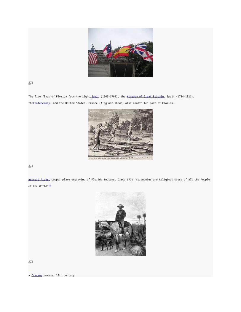
The five flags of Florida from the right,Spain (1565–1763), the Kingdom of Great Britain, Spain (1784–1821), theConfederacy, and the United States. France (flag
not shown) also controlled part of Florida.

Bernard Picart copper plate engraving of Florida Indians, Circa 1721 "Ceremonies and Religious Dress of all the People of the World" [9]
A Cracker cowboy, 19th century
The Battle of Olustee during theAmerican Civil War in 1864
Winter in Florida, 1893
Soldiers and crowds in Downtown Miami 20 minutes after surrender during World War II (1945)
Archaeological research indicates that Florida was first inhabited by Paleo-Indians, the first human inhabitants of the Americas, perhaps as early as 14
thousand years ago. The region was continuously inhabited through the Archaic period (to about 2000 BC). After about 500 BC the previously relatively
uniform Archaic culture began to coalesce into distinctive local cultures.[10]By the 16th century, the earliest time for which there is a historical record,
major Native American groups included the Apalachee (of the Florida Panhandle), the Timucua (of northern and central Florida), the Ais (of the central
Atlantic coast), the Tocobaga (of the Tampa Bayarea), the Calusa (of southwest Florida) and the Tequesta (of the southeastern coast).
Florida was the first part of what is now the continental United States to be visited by Europeans. The earliest known European explorers came with the
Spanish conquistador Juan Ponce de León, who spotted the peninsula on April 2, 1513. According to his chroniclers, Ponce de León named the
region La Florida ("flowery land") because it was then the Easter Season, known in Spanish as Pascua Florida (roughly "Flowery Easter"), and
because the vegetation was in bloom.[11] It is possible Juan Ponce de León was not the first European to reach Florida, however; reportedly, at least
one indigenous tribesman whom he encountered in Florida in 1513 spoke Spanish.[12] From 1513 onward, the land became known as "La Florida",
although after 1630 and throughout the 18th century, Tegesta (after the Tequesta tribe) was an alternate name of choice for the Florida peninsula
following publication of a map by the Dutch cartographerHessel Gerritsz in Joannes de Laet's History of the New World.[13][14]
Over the following century, both the Spanish and French established settlements in Florida with varying degrees of success. In 1559, Don Tristán de
Luna y Arellano established a colony at present-day Pensacola, one of the first European attempts at settlement in the continental United States. It was
abandoned by 1561 due to hurricanes, famine and warring tribes, and the area was not re-inhabited until the 1690s. French
Protestant Huguenots founded Fort Caroline in modern-day Jacksonville in 1564. The following year, the Spanish colony of St. Augustine(San Agustín)
was established, and forces from there conquered Fort Caroline that same year. The Spanish maintained tenuous control over the region by converting
the local tribes, briefly with Jesuits and later with Franciscanfriars.
The area of Spanish Florida diminished with the establishment of English colonies to the north and French colonies to the west. The English weakened
Spanish power in the area by supplying their Creek and Yamasee allies with firearms and urging them to raid the Timucuan and Apalachee client-tribes
of the Spanish. The English attacked St. Augustine, burning the city and its cathedral to the ground several times, while the citizens hid behind the
walls of the Castillo de San Marcos.
Florida was attracting a large number of Africans and African Americans from British-occupied North America who sought freedom from slavery. Once
in Florida, the Spanish Crown converted them to Roman Catholicism and gave them freedom. Those ex-slaves settled in a community north of St.

Augustine, called Gracia Real de Santa Teresa de Mose, the first freedom settlement of its kind in what became the United States. Many of those
slaves were also welcomed by Creek and Seminole Native Americans who had established settlements there at the invitation of the Spanish
government.
Great Britain gained control of Florida and other territory diplomatically in 1763 through thePeace of Paris. The British divided their new acquisitions
into East Florida, with its capital at St. Augustine, and West Florida, with its capital at Pensacola. Britain tried to develop the Floridas through the
importation of immigrants for labor, but this project ultimately failed. Spain received both Floridas after Britain's defeat by the American colonies and the
subsequent Treaty of Versailles in 1783, continuing the division into East and West Florida. They offered land grants to anyone who settled in the
colonies, and many Americans moved to them.
After settler attacks on Indian towns, Seminole Indians based in East Florida began raidingGeorgia settlements, purportedly at the behest of the
Spanish. The United States Army led increasingly frequent incursions into Spanish territory, including the 1817–1818 campaign against the Seminole
Indians by Andrew Jackson that became known as the First Seminole War. Following the war, the United States effectively controlled East Florida. In
1819, by terms of the Adams-Onís Treaty, Spain ceded Florida to the United States in exchange for the American renunciation of any claims on Texas
that they might have from the Louisiana Purchase and $5 million.
In 1830, the Indian Removal Act was passed and as settlement increased, pressure grew on the United States government to remove the Indians from
their lands in Florida. To the chagrin of Georgia landowners, the Seminoles harbored and integrated runaway blacks, known as the Black Seminoles,
and clashes between whites and Indians grew with the influx of new settlers. In 1832, the United States government signed the Treaty of Payne's
Landing with some of the Seminole chiefs, promising them lands west of the Mississippi River if they agreed to leave Florida voluntarily. Many of the
Seminoles left at this time, while those who remained prepared to defend their claims to the land. The U.S. Army arrived in 1835 to enforce the treaty
under pressure from white settlers, and the Second Seminole War began at the end of the year with the Dade Massacre, when Seminoles ambushed
and killed or mortally wounded all but one in a group of 110 Army troops, plus Major Dade and seven officers, marching from Fort Brooke (Tampa) to
reinforce Fort King (Ocala).[15] Between 900 and 1,500 Seminole Indian warriors employed guerrilla tactics against United States Army troops for seven
years until 1842. The U.S. government is estimated to have spent between $20 million and $40 million on the war, at the time an astronomical sum.
The United States quarter dollar coin released March 29, 2004, in honor of the state of Florida.
On March 3, 1845, Florida became the 27th state of the United States of America, although initially its population grew slowly. White settlers continued
to encroach on lands used by the Seminoles, and the United States government resolved to make another effort to move the remaining Seminoles to

the West. The Third Seminole War lasted from 1855 to 1858, and resulted in the removal of most of the remaining Seminoles. Even after three bloody
wars, the U.S. Army failed to force all of the Seminole Indians in Florida to the West.[16] Though most of the Seminoles were forcibly exiled to Creek
lands west of the Mississippi, hundreds, including Seminole leader Aripeka (Sam Jones), remained in the Everglades and refused to leave the native
homeland of their ancestors. Their descendants remain there to this day.
White settlers began to establish cotton plantations in Florida, which required numerous laborers. By 1860 Florida had only 140,424 people, of whom
44% were enslaved. There were fewer than 1000 freeAfrican Americans before the Civil War.[17]
On January 10, 1861, before the start of the American Civil War, Florida declared its secession from the Union; ten days later, the state became a
founding member of the Confederate States of America. The war ended in 1865. On June 25, 1868, Florida's congressional representation was
restored. After Reconstruction, white Democrats succeeded in regaining power in the state legislature. In 1885 they created a new constitution,
followed by statutes through 1889 that effectively disfranchised most blacks and many poor whites over the next several years. Provisions included poll
taxes, literacy tests, and residency requirements. Disfranchisement for most African Americans in the state persisted until the Civil Rights Movement of
the 1960s gained federal legislation to protect their suffrage.
Until the mid-20th century, Florida was the least populous Southern state. In 1900 its population was only 528,542, of whom nearly 44% were African
American.[18] The boll weevil devastated cotton crops, and early 20th century lynchings and racial violence caused a record number of African
Americans to leave the state in the Great Migration to northern and midwestern industrial cities. Forty thousand blacks, roughly one-fifth of their 1900
population, left for better opportunities.[19] Economic prosperity in the 1920s stimulated tourism to Florida. Combined with its sudden elevation in profile
was the Florida land boom of the 1920s, which brought a brief period of intense land development. Devastating hurricanes in 1926 and 1928, followed
by the stock market crash and Great Depression, brought that period to a halt.
Florida's economy did not fully recover until the buildup for World War II. The climate, tempered by the growing availability of air conditioning, and low
cost of living made the state a haven. Migration from the Rust Belt and the Northeast sharply increased the population after the war. In recent decades,
more migrants have come for the jobs in a developing economy. With a population of more than 18 million according to the 2010 census, Florida is the
most populous state in the Southeastern United States, the second most populous state in the South behind Texas, and the fourth most populous in
the United States.
St. Augustine is the oldest city in the United States, established in 1565 by Spain

Key West Historic District
Historic Ybor City in Tampa
The Downtown Miami Historic District has some of the oldest buildings in Miami
Miami Art Deco District, built throughout the 1920-1930s
Geography

A map of Florida showing county names and boundaries
Main article: Geography of Florida
See also: List of counties in Florida and List of Florida state parks
Much of the state of Florida is situated on a peninsula between the Gulf of Mexico, the Atlantic Ocean and the Straits of Florida. Spanning two time
zones, it extends to the northwest into a panhandle, extending along the northern Gulf of Mexico. It is bordered on the north by the states
of Georgiaand Alabama, and on the west, at the end of the panhandle, by Alabama. It is near several Caribbean countries, particularly The
Bahamas and Cuba. Florida is one of the largest states east of the Mississippi River, and only Alaska andMichigan are larger in water area.
At 345 feet (105 m) above mean sea level, Britton Hill is the highest point in Florida and the lowest highpoint of any U.S. state.[20] Much of the state
south of Orlando is low-lying and fairly level; however, some places, such asClearwater, feature vistas that rise 50 to 100 feet (15 – 30 m) above the
water. Much of Central and North Florida, typically 25 miles (40 km) or more away from the coastline, features rolling hills with elevations ranging from
100 to 250 feet (30 – 76 m). The highest point in peninsular Florida, Sugarloaf Mountain, is a 312-foot (95 m) peak in Lake County.[21]
Boundaries
The state line begins in the Atlantic Ocean, traveling west, south, and north up the thalweg of the Saint Mary's River. At the origin of that river, it then
follows a straight line nearly due west and slightly north, to the point where the confluence of the Flint River (from Georgia) and the Chattahoochee
River (down the Alabama/Georgia line) used to form Florida's Apalachicola River. (Since Woodruff Dam was built, this point has been under Lake
Seminole.) The border with Georgia continues north through the lake for a short distance up the former thalweg of the Chattahoochee, then with
Alabama runs due west along latitude 31°N to the Perdido River, then south along its thalweg to the Gulf via Perdido Bay. The water boundary is 3
nautical miles (3.5 mi; 5.6 km) offshore in the Atlantic Ocean[22] and 9 nautical miles (10 mi; 17 km) offshore in the Gulf of Mexico.[22] Much of the state
is at or near sea level.

Climate
Main article: Climate of Florida
See also: List of Florida hurricanes and List of all-time high and low temperatures by state
Hurricane Andrew bearing down on Florida on August 23, 1992.
The climate of Florida is tempered somewhat by the fact that no part of the state is very distant from the ocean. North of Lake Okeechobee, the
prevalent climate is humid subtropical (Köppen: Cfa), while coastal areas south of the lake (including the Florida Keys) have a true tropical
climate (Köppen: Aw).[23] Mean high temperatures for late July are primarily in the low 90s Fahrenheit (32–34 °C). Mean low temperatures for early to
mid January range from the low 40s Fahrenheit (4–7 °C) in northern Florida to the mid-50s (≈13 °C) in southern Florida. With an average daily
temperature of 70.7 °F (21.5 °C), it is the warmest state in the country.[24]
In the summer, high temperatures in the state seldom exceed 100 °F (38 °C). Several record cold maxima have been in the 30s °F (−1 to 4 °C) and
record lows have been in the 10s (−12 to −7 °C). These temperatures normally extend at most a few days at a time in the northern and central parts of
Florida. Southern Florida, however, rarely encounters freezing temperatures.
The hottest temperature ever recorded in Florida was 109 °F (43 °C), which was set on June 29, 1931 in Monticello. The coldest temperature was −2
°F (−19 °C), on February 13, 1899, just 25 miles (40 km) away, in Tallahassee.
Due to the tropical climate Florida rarely receives snow. However, on very rare occasions, a combination of cold moisture and freezing temperatures
can result in snowfall. Frost is more common than snow, occurring several times during the winter months.

Snowball fight on the Florida State Capitol Building in Tallahassee on February 13, 1899
The USDA Plant hardiness zones for the state range from zone 8a (no colder than 10 °F(−12 °C)) in the inland western panhandle to zone 11 (no
colder than 40 °F (4 °C)) in the lower Florida Keys.[25]
Florida's nickname is the "Sunshine State", but severe weather is a common occurrence in the state. Central Florida is known as the lightning capital of
the United States, as it experiences more lightning strikes than anywhere else in the country. [26] Florida has the highest average precipitation of any
state,[citation needed] in large part because afternoonthunderstorms are common in most of the state from late spring until early autumn. A narrow eastern
part of the state including Orlando and Jacksonville receives between 2,400 and 2,800 hours of sunshine annually. The rest of the state, including
Miami, receives between 2,800 and 3,200 hours annually.[27]
Florida leads the United States in tornadoes per area (when including waterspouts)[28] but they do not typically reach the intensity of those in
the Midwest and Great Plains. Hail often accompanies the most severe thunderstorms.
Hurricanes pose a severe threat during hurricane season, which lasts from June 1 to November 30, although some storms have been known to form
out of season. Florida is the most hurricane-prone state, with subtropical or tropical water on a lengthy coastline. From 1851 to 2006, Florida has been
struck by 114 hurricanes, 37 of them major—category 3and above.[29] It is rare for a hurricane season to pass without any impact in the state by at least
a tropical storm. For storms, category 4 or higher, 83% have either hit Florida or Texas.[29] August to October is the most likely period for a hurricane in
Florida.
In 2004, Florida was hit by a record four hurricanes. Hurricanes Charley (August 13), Frances (September 4–5), Ivan (September 16),
and Jeanne (September 25–26) cumulatively cost the state's economy $42 billion. Additionally, the four storms caused an estimated $45 billion in
damage. [30] In 2005, Hurricane Dennis (July 10) became the fifth storm to strike Florida within eleven months. Later,Hurricane Katrina (August 25)
passed through South Florida and Hurricane Rita (September 20) swept through the Florida Keys.Hurricane Wilma (October 24) made landfall
near Cape Romano, just south of Marco Island, finishing another very active hurricane season. Wilma is the second most expensive hurricane in
Florida history, due in part to a five year window in which to file claims.[31]

Florida was the site of the second costliest weather disaster in U.S. history, Hurricane Andrew, which caused more than $25 billion in damage when it
struck on August 24, 1992. In a long list of other infamous hurricane strikes are the 1926 Miami hurricane, the 1928 Okeechobee hurricane, the Labor
Day Hurricane of 1935, Hurricane Donna in 1960, and Hurricane Opal in 1995. Recent research suggests the number of storms are part of a natural
cycle which rises in some years, falls in others.[32][33]
Average High and Low temperatures for various Florida Cities
City Jan Feb Mar Apr May Jun Jul Aug Sep Oct Nov Dec
Jacksonville [34] 65/42 68/45 74/50 79/55 86/63 90/70 92/73 91/73 87/69 80/61 74/51 67/44
Key West [35] 75/65 76/66 79/69 82/72 85/76 88/78 89/80 90/80 88/78 85/76 80/71 76/67
Melbourne [36] 72/51 73/53 77/57 81/61 85/67 88/71 90/73 90/73 88/72 83/67 78/60 73/53
Miami[37] 76/60 78/62 80/65 83/68 87/73 89/76 91/77 91/77 89/76 86/73 82/68 78/63
Orlando [36] 71/49 74/52 78/56 83/60 88/66 91/72 92/74 92/74 90/73 85/66 78/59 73/52
Pensacola [38] 61/43 64/46 70/51 76/58 84/66 89/72 90/74 90/74 87/70 80/60 70/50 63/45
Tallahassee [39] 64/39 68/42 74/47 80/52 87/62 91/70 92/72 92/72 89/68 82/57 73/48 66/41
Tampa [40] 70/51 73/54 77/58 81/62 88/69 90/74 90/75 91/76 89/74 85/67 78/60 72/54
The Royal Poincianagrows in South Florida and blooms in the winter, an indication of South Florida's tropical climate

Summer afternoon showers from theEverglades traveling eastward over Downtown Miami
Fall foliage occurs annually in North and Central Florida.
Snow is uncommon in Florida, but has occurred in every major Florida city at least once.
Winter in Miami. Miami's mild winters make it a major tourist destination in the winter.
Fauna
Further information: List of mammals of Florida

American Alligator in the Florida Everglades
Florida is host to many types of wildlife including:
Marine Mammals: Bottlenose Dolphin, Short-finned Pilot Whale, North Atlantic Right Whale, West Indian Manatee
Mammals: Florida panther, Northern River Otter, Mink, Eastern Cottontail Rabbit,Marsh Rabbit, Raccoon, Striped Skunk, Squirrel, White-tailed
deer, Key Deer,Bobcats, Gray Fox, Coyote, Wild Boar, Florida Black Bear, Nine-banded Armadillos
Reptiles: Eastern Diamondback and Pygmy Rattlesnakes, Gopher Tortoise, Greenand Leatherback Sea Turtles, and Eastern Indigo Snake. In
2012, there were about one million American Alligators and 1,500 Crocodiles.[41]
Birds: Bald Eagle, Northern Caracara, Snail Kite, Osprey, White and Brown Pelicans, Sea Gulls, Whooping and Sandhill Cranes, Roseate
Spoonbill, Florida Scrub Jay (state endemic), and others. One subspecies of Wild Turkey, Meleagris gallopavo, namely subspecies osceola, is
found only in the state of Florida.[42] The state is a wintering location for many species of eastern North American birds.
Invertebrates: carpenter ants, termites, American cockroach, Africanized bees, the Miami blue butterfly, and the grizzled mantis.
The only known calving area for the Northern Right Whale is off the coasts of Florida and Georgia.[43]
The native bear population has risen from a historic low of 300 in the 1970s, to 3,000 in 2011.[44]
Since their accidental importation from South America into North America in the 1930s, the Red imported fire ant population has increased its territorial
range to include most of the Southern United States, including Florida. They are more aggressive than most native ant species and have a painful
sting.[45]
A number of non-native snakes and lizards have been released in the wild. In 2010 the state created a hunting season for Burmese andIndian
pythons, African rock pythons, green anacondas, and Nile monitor lizards.[46] Green iguanas have also established a firm population in the southern
part of the state.

Key Deer in the lowerFlorida Keys
The Florida Scrub Jay is found only in Florida.
West Indian Manatee
Florida Panther, native ofSouth Florida
Leatherback Sea Turtle

Whooping Crane
Environmental issues
Main article: Environment of Florida
The beaches of Key Biscayne in Miami
Florida is a low per capita energy user.[47] It is estimated that approximately 4% of energy in the state is generated through renewable resources.
[48] Florida's energy production is 6% of the nation's total energy output, while total production of pollutants is lower, with figures of 5.6% for nitrogen
oxide, 5.1% for carbon dioxide, and 3.5% forsulfur dioxide.[48]
It is believed that significant petroleum resources are located off Florida's western coast in the Gulf of Mexico, but that region has been closed to
exploration since 1981.[49]
Red tide has been an issue on the southwest coast of Florida, as well as other areas. While there has been a great deal of conjecture over the cause of
the toxic algae bloom, there is no evidence that it is being caused by pollution or that there has been an increase in the duration or frequency of red
tides.[50]
The Florida panther is close to extinction. A record 23 were killed in 2009 predominately by automobile collisions, leaving only about 100 individuals in
the wild. The Center for Biological Diversity and others have therefore called for a special protected area for the panther to be established.
[51] Manatees are also dying at a rate higher than their reproduction.

Prior to instituting controlled burns, the state forests and pastures burned for months during the dry season. From the 1940s to the 1970s, the state and
federal government assumed control of burning that largely prevented uncontrolled fires.[52] In 2010, the state burned a record 2,600,000 acres
(11,000 km2).[53]
Recycling
The recycling rate in Florida is estimated at 28% in 2000.[54] In 2008, The Energy, Climate Change, and Economic Security Act of 2008 set a goal of
progressively improving recycling to reach a 75 percent rate by the year 2020.
It directs public entities (schools, state and local public agencies) to report the amount they recycle annually to their counties. Private businesses are
encouraged (but not mandated) to report the amount they recycle to their counties. Finally, the section directs DEP to create the Recycling Business
Assistance Center.[55] Under the new law, each county must implement a recyclable materials recycling program that shall have a goal of recycling
recyclable solid waste by 40 percent by December 31, 2012, 50 percent by 2014, 60 percent by 2016, 70 percent by 2018, and 75 percent by 2020.
[56] The county with the highest recycling rate is Lee County with a 43% recycling rate as of 2008.[57]
Geology
Topographic map of Florida
The Florida peninsula is a porous plateau of karst limestone sitting atopbedrock known as the Florida Platform. The emergent portion of the platform
was created during the Eocene to Oligocene as the Gulf Trough filled with silts, clays, and sands. Flora and fauna began appearing during
the Miocene. No land animals were present in Florida prior to the Miocene.
The largest deposits of potash in the United States are found in Florida.[58]
Extended systems of underwater caves, sinkholes and springs are found throughout the state and supply most of the water used by residents. The
limestone is topped with sandy soils deposited as ancient beaches over millions of years as global sea levels rose and fell. During the last glacial

period, lower sea levels and a drier climate revealed a much wider peninsula, largely savanna.[59] The Everglades, an enormously wide, very slow-
flowing river encompasses the southern tip of the peninsula. Sinkhole damage claims on property in the state exceeded a total of $2 billion from 2006
through 2010.[60]
Florida is tied for last place[61] as having the fewest earthquakes of any US state.[62] Because Florida is not located near any tectonic plate boundaries,
earthquakes are very rare, but not totally unknown.
The 1755 Lisbon earthquake triggered a tsunami that would have struck Central Florida with an estimated 5-foot (1.5 m) wave.[63]
In January, 1879, a shock of Mercalli intensity scale VI occurred near St. Augustine. There were reports of heavy shaking that knocked plaster from
walls and articles from shelves. Similar effects were noted at Daytona Beach 50 miles (80 km) south. The tremor was felt as far south as Tampa and as
far north as Savannah, Georgia.
In January 1880, Cuba was the center of two strong earthquakes that sent severe shock waves through the city of Key West, Florida.[64]
The shock from the 1886 Charleston, South Carolina, earthquake was felt throughout northern Florida, ringing church bells at St. Augustine and
severely jolting other towns along that section of Florida's east coast. Jacksonville residents felt many of the strong aftershocks that occurred in
September, October, and November 1886.[65]
In 2006, a magnitude 6.0 earthquake centered about 260 miles (420 km) southwest of Tampa in the Gulf of Mexico sent shock waves through
southwest and central Florida. The earthquake was too small to trigger a tsunami and no damage was reported.[66]|
Everglades National Parkin Southern Florida
Bahia Honda in the Florida Keys

Ocala National Forest in North Florida
Demographics
Main article: Demographics of Florida
Population
Historical populations
Census Pop. %±
1830 34,730 —
1840 54,477 56.9%
1850 87,445 60.5%
1860 140,424 60.6%
1870 187,748 33.7%
1880 269,493 43.5%
1890 391,422 45.2%
1900 528,542 35.0%
1910 752,619 42.4%
1920 968,470 28.7%
1930 1,468,211 51.6%
1940 1,897,414 29.2%
1950 2,771,305 46.1%
1960 4,951,560 78.7%
1970 6,789,443 37.1%
1980 9,746,324 43.6%
1990 12,937,926 32.7%

2000 15,982,378 23.5%
2010 18,801,310 17.6%
Sources: 1910–2010[67]
The United States Census Bureau estimates that the population of Florida was 19,057,542 on July 1, 2011, a 1.36% increase since the 2010 United
States Census.[68] The center of population of Florida is located in Polk County, in the town of Lake Wales.[69] As of 2009, Florida's population was
estimated to be 18,537,969. The state grew 128,814, or 0.7% from 2007. Using the latest population estimates, Florida is the nation's thirtieth-fastest-
growing state. During Florida's recent peak growth year of 2005, it was the nation's fifth fastest growing state and grew at an annual rate of 2.2%.[70]
About two-thirds of the population was born in another state, the second highest in the country.[71]
In 2010, illegal immigrants constituted an estimated 5.7% of the population. This was the sixth highest percentage of any state in the country.[72]
[73] There were an estimated 675,000 illegal immigrants in the state in 2010.[74]
There were 186,102 military retirees living in the state in 2008.[75]
Racial makeup
According to the 2010 U.S. Census, Florida had a population of 18,801,310. In terms of race and ethnicity, the state was:
75.0% White (57.9% Non-Hispanic White alone)
16.0% Black or African American
0.4% American Indian and Alaska Native
2.4% Asian
0.1% Native Hawaiian and Other Pacific Islander
3.6% from Some Other Race
2.5% from Two or More Races
Hispanics and Latinos of any race made up 22.5% of the population.[76]
Ancestry groups
The largest reported ancestries in the 2000 Census were German (11.8%), Irish (10.3%), English (9.2%), American (8%), Italian
(6.3%),Cuban (5.2%), Puerto Rican (3.0%) French (2.8%), Polish (2.7%) and Scottish (1.8%).[77]
In the 2000 Census, 1,278,586 people in Florida self-identified as having "American" ancestry, most of these people are of English descent and some
are of Scots-Irish descent however have families that have been in the state so long, in many cases since the colonial period, that they choose to
identify simply as having "American" ancestry or do not in fact know their own ancestry.[77][78][79][80][81][82] In the 1980 United States census the largest
ancestry group reported in Florida was English with 2,232,514 Floridians citing that they were of English or mostly English ancestry.[83] Their ancestry
primarily goes back to the original thirteen colonies and for this reason many of them today simply claim "American" ancestry, though they are of
predominately Englishstock. They were followed by Irish at 1,617,433.

Before the American Civil War, when slavery was legal, and during the Reconstruction era that followed, blacks made up nearly half of the state's
population.[84] Their proportion declined over the next century, as many moved north in the Great Migration while large numbers of
northern whites moved to the state. In 1970, non-Hispanic whites were nearly 80% of Florida's population.[85] Recently, the state's proportion of black
residents has begun to grow again. Today, large concentrations of black residents can be found in northern Florida (notably in
Jacksonville, Gainesville, Tallahassee, and Pensacola), the Tampa Bay area, the Orlando area, especially in Orlando and Sanford.
Florida's Hispanic population includes large communities of Cuban Americans in Miami and Tampa, Puerto Ricans in Orlando and Tampa, and Central
American migrant workers in inland West-Central and South Florida. The Hispanic community continues to grow more affluent and mobile.
White Americans of all European backgrounds are present in all areas of the state. Those of English and Irish ancestry are present in large numbers in
all the urban/suburban areas across the state. Native white Floridians, especially those who have descended from long-time Florida families,
affectionately refer to themselves as "Florida crackers". Like whites in most of the other Southern states, they descend mainly from English and Scots-
Irish settlers, as well as some other British settlers.[86]
Cities and metropolitan areas
See also: List of urbanized areas in Florida (by population), Florida census statistical areas, List of municipalities in Florida, andFlorida locations by per
capita income
Largest cities in Florida and Metropolitan Statistical Areas

Florida's population density
Largest cities in Florida
Rank City Year of Incorporation Metropolitan AreaPopulation
(2010 census)Population Density
(people per mi2)City's Size
(mi2)
1 Jacksonville 1832 Jacksonville metropolitan area 821,784 1,061.6 885
2 Miami 1896 Miami metropolitan area 408,568 12,139.5 55.3
3 Tampa 1855 Tampa Bay Area 335,709 2,969.6 170.6
4Saint Petersburg
1903 Tampa Bay Area 244,769 1,800 137.6
5 Orlando 1885 Orlando metropolitan area 238,300 2,327.3 110.7
6 Hialeah 1925 Miami metropolitan area 224,669 11,701.2 19.7
7 Tallahassee 1825 Tallahassee metropolitan area 181,376 1,809.3 103.1

Largest cities in Florida
Rank City Year of Incorporation Metropolitan AreaPopulation
(2010 census)Population Density
(people per mi2)City's Size
(mi2)
8 Fort Lauderdale 1911 Miami metropolitan area 165,521 5,221.8 36.0
9 Port Saint Lucie 1961Port St. Lucie metropolitan area
164,603 1,444.5 76.7
10 Pembroke Pines 1960 Miami metropolitan area 154,750 4,671.9 34.4
Largest metropolitan areas in Florida
Rank
Metropolitan area Population
1 Miami metropolitan area 5,564,635
2 Tampa Bay Area 2,783,243
3 Orlando metropolitan area 2,134,411
4 Jacksonville metropolitan area 1,345,596
5 North Port–Bradenton–Sarasota 702,281
The largest metropolitan area in the state as well as the entire southeastern United States is the Miami metropolitan area, with about 5.5 million people.
The Tampa Bay Area, with over 2.7 million people, is the second largest; the Orlando metropolitan area, with over 2.1 million people, is the third; and
the [[Jacksonville metropolitan area, with over 1.3 million people, is fourth.

Florida has twenty Metropolitan Statistical Areas (MSAs) defined by the United States Office of Management and Budget (OMB). Thirty-nine of
Florida's sixty-seven counties are in an MSA. Reflecting the distribution of population in Florida, Metropolitan areas in the state are concentrated
around the coast of the peninsula. They form a continuous band on the east coast of Florida, stretching from the Jacksonville MSA to the Miami-Fort
Lauderdale-Pompano Beach MSA, including every county on the east coast, with the exception ofMonroe County. There is also a continuous band of
MSAs on the west coast of the peninsula from the Tampa-St. Petersburg-Clearwater MSA to the Naples-Marco Island MSA, including all of the coastal
counties from Hernando County to Collier County. The interior of the northern half of the peninsula also has several MSAs, connecting the east and
west coast MSAs. A few MSAs are scattered across the Florida panhandle.
Downtown Miami
Downtown Tampa
Downtown Orlando

Downtown Jacksonville
Downtown Sarasota
Languages
First settled by the Spanish in the 16th century, today, 19% of Floridians speak Spanish, and is the most widely taught second language.
As of 2005, 74.54% of Florida residents age 5 and older spoke English at home as a first language, while 18.65% spoke Spanish, and French
Creole (almost entirely Haitian Creole) was spoken by 1.73% of the population. In all, 25.45% of Florida's population age 5 and older spoke a language
other than English.[87]
Florida's public education system identified over 150 first languages other than English spoken in the homes of students.[citation needed] In 1990, the League
of United Latin American Citizens (LULAC) won a class action lawsuit against the state Florida Department of Education that required educators to be
trained in teaching English for Speakers of Other Languages (ESOL).[citation needed]
Article II, Section 9, of the Florida Constitution provides that "English is the official language of the State of Florida." This provision was adopted in 1988
by a vote following an Initiative Petition.
Religion

As of the year 2000, the three largest denominational groups in Florida are Catholic, Evangelical Protestant, and Mainline Protestant.[88]
Florida is mostly Protestant, but Roman Catholicism is the single largest denomination in the state. There is also a sizable Jewish community, located
mainly in South Florida; this is the largest Jewish population in the South and the third largest in the country behind New York and California.
[89] Florida's current religious affiliations are shown in the table below:[90]
Roman Catholic, 26%
Protestant, 48%
Baptist , 9%
Methodist , 6%
Pentecostal , 3%
Jewish, 3%
Jehovah's Witness , 1%
Muslim, 1%
Orthodox , 1%
other religions, 1%
non-religious, 16%
Governance
Main article: Government of Florida
See also: List of Florida Governors, United States Congressional Delegations from Florida, and Florida Cabinet
Florida Capitol buildings.

The basic structure, duties, function, and operations of the government of the state of Florida are defined and established by the Florida Constitution,
which establishes the basic law of the state and guarantees various rights and freedoms of the people. The state government consists of three
separate branches: judicial, executive, and legislative. The legislature enacts bills, which, if signed by the governor, become Florida Statutes.
The Florida Legislature comprises the Florida Senate, which has 40 members, and the Florida House of Representatives, which has 120 members.
The current Governor of Florida is Rick Scott. The Florida Supreme Court consists of a Chief Justice and six Justices.
There are 67 Counties in Florida, but some reports show only 66 because of Duval County, which is consolidated with the City of Jacksonville. There
are 379 cities in Florida (out of 411) that report regularly to the Florida Department of Revenue, but there are other incorporated municipalities that do
not. The primary source of revenue for the state government is sales tax (Florida does not impose a personal income tax), but the primary revenue
source for cities and counties is property tax.
Political history
From 1885 to 1889, the state legislature passed statutes with provisions to reduce voting by blacks and poor whites, which had threatened white
Democratic power with a populist coalition. As these groups were stripped from voter rolls, white Democrats established power in a one-party state, as
happened across the South. In 1900 African Americans comprised 44% of the state's population,[91] the same proportion as before the Civil War, but
they were effectively disfranchised. From 1877 to 1948, Florida voted for the Democratic candidate for president in every election except for the 1928
election.
The Florida Supreme Court
In response to segregation, disfranchisement and agricultural depression, many African Americans migrated from Florida to northern cities in the Great
Migration, in waves from 1910–1940, and again starting in the later 1940s. They moved for jobs, better education for their children and the chance to
vote and participate in society. Given migration of other groups into Florida (as noted in other sections of this article), by 1960 the proportion of African
Americans in the state had declined to 18%.[92]
Further information: Political party strength in Florida
Since 1952, despite having a majority of registered Democrats, the state has voted for the Republican presidential candidate in every election except
for the 1964, 1976, and 1996elections, when the Democrat was from the South, and the 2008 election, which was the first time since Franklin D.
Roosevelt that Florida had voted for a Northern Democrat. The first post-reconstruction Republican congressional representative was elected in 1954.
[93] The state's first post-reconstruction Republican senator was elected in 1968,[94] two years after the first post-reconstruction Republican governor.[95]

Presidential elections results
Year Republican Democratic
2008
48.22% 4,045,624 50.96% 4,282,074
2004
52.10% 3,964,522 47.09% 3,583,544
2000
48.85% 2,912,790 48.84% 2,912,253
1996
42.32% 2,244,536 48.02% 2,546,870
1992
40.89% 2,173,310 39.00% 2,072,698
1988
60.87% 2,618,885 38.51% 1,656,701
1984
65.32% 2,730,350 34.66% 1,448,816
1980
55.52% 2,046,951 38.50% 1,419,475
1976
46.64% 1,469,531 51.93% 1,636,000
1972
71.91% 1,857,759 27.80% 718,117
1968
40.53% 886,804 30.93% 676,794
1964
48.85% 905,941 51.15% 948,540
1960
51.51% 795,476 48.49% 748,700
In 1998, Democrats were described as most dominant in areas of the state with high percentages of racial minorities, as well as transplanted white
liberals coming primarily from the Northeastern United States.[96] South Florida and the Miami metropolitan area was a good example of this as it had a
particularly high level of both racial minorities and white liberals. Because of this, the area has been one of the most Democratic areas of the state. The
Daytona Beach area has been, to a lesser extent, somewhat similar to South Florida demographically and the city of Orlando had a large Hispanic
population, which often favored Democrats. Republicans remain dominant throughout much of the rest of Florida particularly in the more rural and
suburban areas, as is the case throughout the Deep South.[96]

The fast growing I-4 corridor area, which runs through Central Florida and connects the cities ofDaytona Beach, Orlando, and Tampa/St. Petersburg,
had a fairly similar number of both Republican and Democratic voters. The area is often seen as a merging point of the conservative northern portion of
the state and the liberal southern portion making it the biggest swing area in the state. In recent times, whichever way the I-4 corridor area, containing
40% of Florida voters, votes has often determined who will win the state of Florida in presidential elections.[97]
The Democratic Party has maintained an edge in voter registration, both statewide and in 40 of the 67 counties, including Miami-Dade County, Broward
County, and Palm Beach County, the state's three most populous counties.[98]
There were 800 federal corruption convictions from 1988 to 2007, more than any other state.[99]
Recent elections
Main article: United States presidential election in Florida, 2000
In 2000, George W. Bush won the U.S. Presidential election by a margin of 271–266 in the Electoral College.[100] Of the 271 electoral votes for Bush, 25
were cast by electors from Florida.[101] Reapportionment following the 2000 United States Census gave the state two more seats in the House of
Representatives.[102]
Despite the Democratic advantage in registration, as of 2008, Republicans controlled the governorship and most other statewide elective offices; both
houses of the state legislature; and 15 of the state's 25 seats in the House of Representatives. Florida has been listed as aswing state in Presidential
elections since 1950, voting for the losing candidate once in that period of time.[103] In the closely contested2000 election the state played a pivotal role.
[100][101][104][105][106][107]
In 2008, delegates of both the Republican Florida primary election and Democratic Florida primary election were stripped of half of their votes when the
conventions met in August due to violation of both parties' national rules.
In the 2010 elections, Republicans solidified their dominance state-wide, by winning the governor's mansion, maintaining firm majorities in both houses
of the state legislature. They won four previously Democratic-held seats to create a 19–6 Republican majority delegation representing Florida in the
federal House of Representatives. As a result of the 2010 United States Census, Florida will gain two House of Representative seats in 2012.[102]
Statutes
All potable water resources have been controlled by the state government through five regional water authorities since 1972.[108]
The state repealed mandatory auto inspection in 1981.[109]
In 1972, the state made personal injury protection auto insurance mandatory for drivers, becoming the second in the nation to enact ano-fault
insurance law. The ease of receiving payments under this law is seen as precipitating a major increase in insurance fraud.[110]Auto insurance fraud was
the highest in the nation in 2011, estimated at close to $1 billion.[111] Fraud is particularly centered in the Miami-Dade metropolitan and Tampa areas.[112]
[113][114]
Law enforcement
Further information: List of law enforcement agencies in Florida and Crime in Florida

Florida was ranked the fifth most dangerous state in 2009. Ranking was based on the record of serious felonies committed in 2008.[115]
The state was the sixth highest scammed state in 2010. It ranked first in mortgage fraud in 2009.[116]
In 2009, 44% of highway fatalities involved alcohol.[117]
Florida is one of seven states that prohibit the open carry of handguns. This law was passed in 1987.[118]
Health
There were 2.7 million Medicaid patients in Florida in 2009. The governor has proposed adding $2.6 billion to care for the expected 300,000 additional
patients in 2011.[119] The cost of caring for 2.3 million clients in 2010 was $18.8 billion.[120] This is nearly 30% of Florida's budget.[121]
Medicaid paid for 60% of all births in Florida in 2009.[31]
The state has a program for those not covered by Medicaid.
Some people suffer from various allergies from plants at varying seasons including pollen from oak trees and juniper shrubs.[122]
Architecture
While many houses and commercial buildings look similar to those elsewhere in the country, the state has appropriated some unique styles in some
section of the state including Spanish revival, Florida vernacular, and Mediterranean Revival Style.[123][124]
Economy
Launch of Space Shuttle Columbia from theKennedy Space Center

The Port of Miami is the world's largest cruise ship port, and is the headquarters of many of the world's largest cruise companies.
The Brickell Financial District in Miami contains the largest concentration of international banks in the United States.[125][126]
South Florida's climate is ideal for growingsugarcane.
Historically, the economy of Florida was dependent on agricultural products such as citrus, sugar, cotton and cattle. In the twentieth century, tourism,
industry, construction, international banking, biomedical and life sciences, healthcare research, simulation training, aerospace and defense, and
commercial space travel have contributed to the state's economic development.[citation needed]
The Gross Domestic Product (GDP) of Florida in 2010 was $748 billion.[127] Its GDP is the fourth largest economy in the United States.[128] In 2010, it
became the fourth largest exporter of trade goods.[129] The major contributors to the state's gross output in 2007 were general services, financial
services, trade, transportation and public utilities, manufacturing and construction respectively. In 2010–11, the state budget was $70.5 billion, having
reached a high of $73.8 billion in 2006–07.[130] Chief Executive Magazine name Florida the third "Best State for Business" in 2011.[131]
The economy is driven almost entirely by its nineteen metropolitan areas. In 2004, they had a combined total of 95.7% of the state's domestic product.
[132]
Personal income

Preliminary data from the Bureau of Economic Analysis shows that in 2011, per capita personal income was $39,563, ranking 27th in the nation.[133]
The state was one of the few states to not have a state minimum wage law of its own and was therefore obliged to follow federal minimum wage law.
This changed in 2004, when voters passed a constitutional amendment establishing a state minimum wage and (unique among minimum wage laws)
mandating that it be adjusted for inflation annually. For 2010, the calculated Florida minimum wage was lower than the federal rate of $7.25, so the
federal rate controlled.[134]
Florida is one of the seven states that do not impose a personal income tax.
According to a study by Experian, Florida has 4 cities in the top 25 cities in the country with the most credit card debt.[135]
There were 2.4 million Floridians living in poverty in 2008. 18.4% of children 18 and younger were living in poverty.[136] Miami is the sixth poorest big city
in the United States.[137]
The state also had the second-highest credit card delinquency rate, with 1.45% of cardholders in the state more than 90 days delinquent on one or
more credit cards.[138]
In 2010, over 2.5 million Floridians were on food stamps, up from 1.2 million in 2007. To qualify, Floridians must make less than 133% of the federal
poverty level, which would be under $29,000 for a family of four.[139]
Real estate
In the early 20th century, land speculators discovered Florida, and businessmen such as Henry Plant and Henry Flagler developed railroad systems,
which led people to move in, drawn by the weather and local economies. From then on, tourism boomed, fueling a cycle of development that
overwhelmed a great deal of farmland.
Because of the collective effect on the insurance industry of the hurricane claims of 2004, homeowners insurance has risen 40% to 60% and
deductibles have risen.[30]
At the end of the third quarter in 2008, Florida had the highest mortgage delinquency rate in the country, with 7.8% of mortgages delinquent at least 60
days.[138] A 2009 list of national housing markets that were hard hit in the real estate crash included a disproportionate number in Florida.[140] The early
21st century building boom left Florida with 300,000 vacant homes in 2009, according to state figures.[141] In 2009, the US Census Bureau estimated
that Floridians spent an average 49.1% of personal income on housing-related costs, the third highest percentage in the country.[142]
In the third quarter of 2009, there were 278,189 delinquent loans, 80,327 foreclosures.[143] Sales of existing homes for February 2010 was 11,890, up
21% from the same month in 2009. Only two metropolitan areas showed a decrease in homes sold: Panama City andBrevard County. The average
sales price for an existing house was $131,000, 7% decrease from the prior year.[144][dubious – discuss]
Labor
As of February 2011, the state's unemployment rate was 11.5%.[145]
In 2009, there were 89,706 federal workers employed within the state.[146]
In 2012, government was a top employer in all counties in the state. This was mainly due to the prevalence of teachers, whose school boards employ
nearly 1 out of every 30 workers in the state. The military was the top employer in three counties.[147]

Agriculture and fishing
Historically, Florida's economy was based upon cattle farming and agriculture (especially sugarcane, citrus, tomatoes, andstrawberries).
The second largest industry is agriculture. Citrus fruit, especially oranges, are a major part of the economy, and Florida produces the majority of citrus
fruit grown in the U.S.—in 2006 67% of all citrus, 74% of oranges, 58% of tangerines, and 54% of grapefruit. About 95% of commercial orange
production in the state is destined for processing (mostly as orange juice, the official state beverage).[148] Citrus canker continues to be an issue of
concern. Other products include sugarcane, strawberries, tomatoes and celery.[149] The state is the largest producer of sweet corn and green beans for
the country.[150]
The Everglades Agricultural Area is a major center for agriculture. The environmental impact of agriculture—especially water pollution—is a major
issue in Florida today.
In 2009, fishing was a $6 billion industry, employing 60,000 jobs for sports and commercial purposes.[151]
Mining
Phosphate mining, concentrated in the Bone Valley, is the state's third-largest industry. The state produces about 75% of the phosphate required by
farmers in the United States and 25% of the world supply, with about 95% used for agriculture (90% for fertilizerand 5% for livestock feed supplements)
and 5% used for other products.[152]
Government
Since the arrival of the NASA Merritt Island launch sites on Cape Canaveral (most notably Kennedy Space Center) in 1962, Florida has developed a
sizable aerospace industry.
Another major economic engine in Florida is the United States Military. There are currently 24 military bases in the state, housing threeUnified
Combatant Commands; United States Central Command in Tampa, United States Southern Command in Doral, and United States Special Operations
Command in Tampa. There are 109,390 U.S. military personnel currently stationed in Florida,[153]contributing, directly and indirectly, $52 billion a year
to the state's economy.[154]
Industry
This section does
not cite anyreferences or
sources.(February 2012)

The Miami Civic Center has the second-largest concentration of medical and research facilities in the United States.[155]
After the watershed events of Hurricane Andrew in 1992, the State of Florida began investing in economic development through OTTED (Office of
Trade, Tourism, and Economic Development). Governor Jeb Bush realized that watershed events such as Andrew negatively impacted Florida's
backbone industry of tourism severely. The office was directed to target Medical/Bio-Sciences among others. Three years later, TheScripps Research
Institute (TSRI) announced it had chosen Florida for its' newest expansion. In 2003, TSRI announced plans to establish a major science center in Palm
Beach, a 364,000 square feet (33,800 m2) facility on 100 acres (40 ha), which TSRI planned to occupy in 2006.[156]
At the same time that Scripps started operations in Florida, Tavistock Group, an investment firm that held 7,000 acres (2,800 ha) of land immediately
South East ofOrlando International Airport began formulating new possibilities for its land use after the decline in tourism to the state. Tavistock
decided to use part of the land to establish a Bio-Sciences cluster. In 2005, the State of Florida along with Tavistock Group and the University of
Central Florida agreed that Tavistock would donate 50 acres (20 ha) and $12.5 Million (which the state would match for a total of $25 Million) to start
the UCF College of Medicine and the Burnett School of Biomedical Sciences. The UCF College of Medicine won approval from the State Board of
Governors in 2006. That decision was key to attracting Sanford-Burnham Medical Research Institute to Central Florida. Tavistock then donated another
50 acres (20 ha) and $17.5 Million to Sanford-Burnham which allowed Sanford-Burnham's East Coast expansion. In February and March
2007, Nemours and theThe V/A(respectively) announced Lake Nona as the site of two new hospitals.[citation needed]
Other prospective tenants of the Lake Nona Medical City included M.D. Anderson Cancer Center, the University of Florida research center,
and Valencia Community College.[citation needed]
It was determined in 2008 from a study done by Arduin, Laffer and Moore Econometrics that the Lake Nona Medical City cluster has in two years
reached 80% of the Milken Numbers which were based on the commitments made by the economic development statements. The study then released
new projections for the 10 year period which included 30,000 jobs created and a $7.6 Billion economic impact.[157]
This section does
not cite anyreferences or
sources.(February 2012)
Florida has become a simulation training cluster.[citation needed] There are the aerospace and defense industries. Companies have expanded.
The Electronic Arts Tiburon, the division responsible for popular games such as the Madden NFL series as well as other sports games, has given way
to a cluster of highly skilled digital media workers who transformed their craft into simulation and simulation training. The United States Military has
been the driving force and primary client of these simulation training firms.[citation needed] It has since spilled over into local police and fire agencies across
the country and across the world. Aviation simulation has also benefited greatly from the advances of the Central Florida simulation training cluster.
[citation needed]
Tourism
Tourism makes up the largest sector of the state economy. Warm weather and hundreds of miles of beaches attract about 60 million visitors to the
state every year. Florida was the top destination state in 2011. 42% of poll respondents living in the Northeast United States said they planned on
visiting Florida over spring break.[158]

Amusement parks, especially in the Orlando area, make up a significant portion of tourism. The Walt Disney World Resort is the largest vacation resort
in the world, consisting of four theme parks and more than 20 hotels in Lake Buena Vista, Florida; it, andUniversal Orlando Resort, Busch
Gardens, SeaWorld, and other major parks drive state tourism. Many beach towns are also popular tourist destinations, particularly in the winter
months. 23.2 million tourists visited Florida beaches in 2000, spending $21.9 billion.[159]
The public has a right to beach access under the public trust doctrine. However, some areas have access effectively blocked by private owners for a
long distance.[160]
Energy
Florida ranks 45th out of 50 states in total energy consumption per capita, despite the heavy reliance on commercial and residential air conditioning.
This includes coal, natural gas, petroleum, and retail electricity sales.[47][not in citation given]
Education
Main article: Education in Florida
Florida's public primary and secondary schools are administered by the Florida Department of Education.
State University System
The State University System of Florida was founded in 1905, and is governed by the Florida Board of Governors. During the 2010 academic year,
312,216 students attended one of these member institutions.
Florida A&M University
Tallahassee
Florida Atlantic University
Boca Raton

Florida Gulf Coast University
Fort Myers
Florida International University
Miami
Florida State University
Tallahassee
New College of Florida
Sarasota

University of Central Florida
Orlando
University of Florida
Gainesville
University of North Florida
Jacksonville
University of South Florida
Tampa

University of West Florida
Pensacola
Private universities
Florida's first private university, Stetson University, was founded in 1883. The Independent Colleges and Universities of Florida is an association of 28
private, educational institutions in the state.[161] This Association reported that their member institutions served over 121,000 students in the fall of 2006.
[162]
Barry University
Miami Shores
Flagler College
Saint Augustine
University of Miami
Coral Gables

Nova Southeastern University
Fort Lauderdale
Stetson University
DeLand
University of Tampa
Tampa
Infrastructure
Communication
27% of Floridians exclusively own cell phones for communication; no landline. Nationally, figures vary from 13–35%, with the higher percentages an
indication of lower income.[163]
Transportation
Main article: Transportation in Florida

The Miami Metrorail is the state's onlyrapid transit system. About 15% of Miamians use public transit daily.
Public transit
Miami's public transportation is served by Miami-Dade Transit that runs Metrorail, a heavy rail rapid transit system, Metromover, a people mover train
system in Downtown Miami, andMetrobus, Miami's bus system. Metrorail runs throughout Miami-Dade County and has two lines and 23 stations
connecting to Downtown Miami's Metromover and Tri-Rail. Metromover has three lines and 21 stations throughout Downtown Miami. Outside of Miami-
Dade County, public transit in the Miami metropolitan area is served by Broward County Transit and Palm Tran; intercountycommuter rail service is
provided by Tri-Rail, with 18 stations including the region's three international airports.
Orlando utilizes the LYNX bus system as well as a downtown bus service called LYMMO, and has attempted to plan a local light rail service for years.
A commuter rail service – SunRail – has been approved by all concerning counties and is in final planning stages.
Tampa and its surrounding area use the Hillsborough Area Regional Transit Authority system ( "HART"). In addition, downtown Tampa has continuous
trolley services in the form of a heritage trolley powered by Tampa Electric Company. Pinellas County and St. Petersburg provide similar services
through the Pinellas Suncoast Transit Authority or "PSTA". The beaches of Pinellas County also have a continuous trolley bus. Downtown St.
Petersburg has a trolley system.
Public transit usage in Florida
Rank
CityDaily weekday
passenger ridership
Populationserved
% Dailytransit riders
Modes of transit
1 Miami 369,600[164] 2,496,435 14.8%Tri-Rail (commuter rail), Miami Metrorail (heavy rail), Metromover(people mover), & Metrobus
2 Fort Lauderdale 125,710 1,748,066 7.2% Tri-Rail (commuter rail), & Broward County Transit (bus)
3 Orlando 84,061 2,134,411 3.9% LYNX (bus)

4 Tampa 40,000[165] 1,229,226 3.2% HART (bus), & TECO Line Streetcar
5West Palm Beach
34,000[165] 1,320,134 2.6% Tri-Rail (commuter rail), & Palm Tran (bus)
6 Jacksonville 28,220 821,784 3.4% Jacksonville Transportation Authority: Bus, and JTA Skyway (people mover)
Highways
Further information: State Roads in Florida
The Sunshine Skyway Bridgecrosses Tampa Bay, and is one of the largest bridges in the state.
Florida's interstates, state highways and U.S. Highways are maintained by the Florida Department of Transportation. Florida's interstate highway
system contains 1,473 miles (2,371 km) of highway, and there are 9,934 miles (15,987 km) of non-interstate highway in the state, such as Florida state
highways and U.S. Highways.
In 2011, there were about 9,000 retail gas stations in the state.On an average day, Floridians consume 21 million gallons of gasoline, ranking it third in
national use.[166][167]
Motorists have the 45th worst rate of car insurance in the country. 24% are uninsured.[168]Drivers between 15 and 19 years of age averaged 364 car
crashes a year per ten thousand licensed Florida drivers in 2010. Drivers 70 and older averaged 95 per 10,000 during the same time frame. A
spokesperson for the non-profit Insurance Institute said that "Older drivers are more of a threat to themselves."[169]
State highways are numbered according to convention. The first digits of state highways[170] are numbered with the first digit indicating what area of the
state the road is in, from 1 in the north and east to 9 in the south and west. Major north-south state roads generally have one- or two-digit odd route
numbers that increase from east to west, while major east-west state roads generally have one- or two-digit even route numbers that increase from
north to south. Roads of secondary importance usually have three-digit route numbers. The first digit x of their route number is the same as the first

digit of the road with two-digit number x0 to the immediate north. The three-digit route numbers also increase from north to south for even numbers and
east to west for odd numbers.
Following this convention, State Road 907, or Alton Rd. on Miami Beach, is farther east than State Road 997, which is Krome Ave, or the farthest west
north-south road in Miami-Dade County. One notable exception to the convention is State Road 826, or the Palmetto Expressway (pictured at the right
heading north) which, although even numbered, is signed north-south. State roads can have anywhere from one to four digits depending on the
importance and location of the road.[171] County roads often follow this same system.
Prior to the construction of routes under the Federal Aid Highway Act of 1956, Florida began construction of a long cross-state toll road,Florida's
Turnpike. The first section, from Fort Pierce south to the Golden Glades Interchange was completed in 1957. After a second section north through
Orlando to Wildwood (near present-day The Villages), and a southward extension around Miami to Homestead, it was finished in 1974.
Florida's primary interstate routes include:
I-4, which bisects the state, connecting Tampa, Lakeland, Orlando, and Daytona Beach, connecting with I-95 in Daytona Beachand I-
75 in Tampa.
I-10, which traverses the panhandle, connecting Jacksonville, Lake City, Tallahassee and Pensacola, with junctions with I-
95 inJacksonville and I-75 in Lake City.
I-75, which enters the state near Lake City (45 miles (72 km) west of Jacksonville) and continues southward
through Gainesville,Ocala, Tampa's eastern suburbs, Bradenton, Sarasota, Fort Myers and Naples, where it crosses the "Alligator Alley" as a toll
roadto Fort Lauderdale before turning southward and terminating in Hialeah/Miami Lakes having junctions with I-10 in Lake City and I-
4 inTampa.
I-95, which enters the state near Jacksonville and continues along the Atlantic Coast through Daytona Beach Melbourne/Titusville , Palm
Bay, Vero Beach, Fort Pierce, Port Saint Lucie, Stuart, West Palm Beach, and Fort Lauderdale before terminating in Downtown Miami, with
junctions with I-10 in Jacksonville and I-4 in Daytona Beach.
Intercity rail
Amtrak connects all major cities in Florida. This West Palm Beach Stationserves Amtrak and Tri-Rail commuter railservice.

Florida is served by Amtrak, operating numerous lines throughout, connecting the state's largest cities to points north in the United States and Canada.
The busiest Amtrak train stations in Florida in 2011 were: Sanford (259,944), Orlando (179,142), Tampa Union Station (140,785),Miami (94,556),
and Jacksonville (74,733).[172] Sanford, in Greater Orlando, is the southern terminus of the Amtrak Auto Train, which originates at Lorton, Virginia, south
of Washington, D.C.. Orlando is also the eastern terminus of the Sunset Limited, which travels across the southern United States via New
Orleans, Houston, and San Antonio to its western terminus of Los Angeles. Florida is served by two additional Amtrak trains (the Silver Star and
the Silver Meteor), which operate between New York City and Miami. Miami Central Station, the city's newunion station is under construction, and is
expected to be completed in 2013.
The Miami metropolitan area is connected by Tri-rail, a 70.9 miles (114.1 km) long line with 18 stations which operates on Amtrak rails.
The Florida Department of Transportation was preparing to build a high speed rail betweenTampa, Lakeland and Orlando.[173] This was to be the first
phase of the Florida High Speed Rail system.[174] Soil work began in July 2010[175][176] and construction of the line was slated to begin in 2011, with the
initial Tampa-Orlando phase completed by 2014.[177] The second phase, would have extended the line to Miami. Governor Scott, however, refused
federal funds and the project has been canceled.
Airports
Miami International Airport is the world's 10th-largest cargo airport, and the state's busiest airport.
See also: List of airports in Florida
Major international airports in Florida which processed more than 15 million passengers each in 2010 are Miami International
Airport (35,698,025), Orlando International Airport(34,877,899), Fort Lauderdale-Hollywood International Airport (22,412,627) and Tampa International
Airport (16,645,765).
Secondary airports, with annual passenger traffic exceeding 5 million each in 2010, include Southwest Florida International Airport (Fort Myers)
(7,514,316), Palm Beach International Airport (West Palm Beach) (5,887,723), and Jacksonville International Airport (5,601,500).[178]
Florida's extensive coastline made it a perceived target during World War II, so the government built airstrips throughout the state; today,
approximately 400 airports are still in service. According to the National Drug Intelligence Center, Florida has 131 public airports, and more than 700
private airports, airstrips, heliports, and seaplane bases.[179]
Sports
See also: Florida Sports Hall of Fame and List of sports teams in Florida
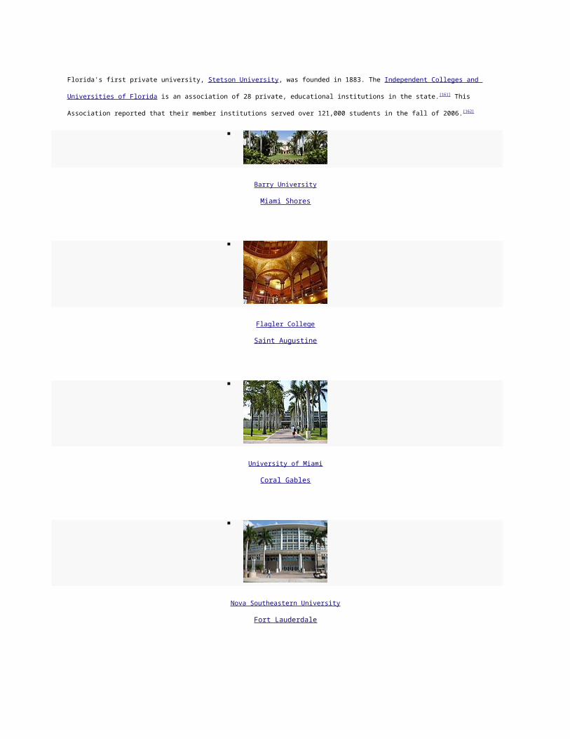
Fourteen, about half, of all Major League Baseball teams conduct spring training in the state. Throughout MLB history other teams, at one time or
another, held spring training in Florida.
Yet Florida did not have a permanent major-league-level professional sports team until the American Football League added the Miami Dolphins in
1966. The state now has three NFL teams, two MLB teams, two NBA teams, and two NHL teams.
The state of Florida has given professional sports franchises some subsidies in the form of tax breaks since 1991.[180]
Three of the Arena Football League's teams are in Florida.
Golf, tennis, and auto racing are popular. NASCAR (headquartered in Daytona Beach) begins all three of its major Series in Florida atDaytona
International Speedway, and ends all three Series in November at Homestead-Miami Speedway. The PGA of America is headquartered in Palm Beach
Gardens while the LPGA is headquartered in Daytona Beach.
Minor league baseball, football, basketball, ice hockey, soccer and indoor football teams are based in Florida. Florida's universities have a number
of collegiate sport teams. Florida is the traditional home for Major League Baseball spring training, with teams informally organized into the "Grapefruit
League".
Club League Venue Championships
Miami Dolphins National Football League Sun Life Stadium (Miami Gardens) 2 (1972, 1973)
Miami Heat National Basketball Association American Airlines Arena (Miami) 2 (2006, 2012)
Miami Marlins Major League Baseball Marlins Park (Miami) 2 (1997, 2003)
Florida Panthers National Hockey League BankAtlantic Center (Sunrise) 0
Tampa Bay Buccaneers
National Football League Raymond James Stadium (Tampa) 1 (2003)
Tampa Bay Rays Major League Baseball Tropicana Field (St. Petersburg) 0
Tampa Bay Lightning National Hockey League Tampa Bay Times Forum (Tampa) 1 (2004)
Orlando Magic National Basketball Association Amway Center (Orlando) 0

Jacksonville Jaguars National Football League EverBank Field (Jacksonville) 0
Auto-racing tracks
Daytona International Speedway
Homestead-Miami Speedway
Sebring International Raceway
Streets of St. Petersburg
Walt Disney World Speedway
Palm Beach International Raceway
American Airlines Arena
Miami
Miami Heat
Amway Center
Orlando
Orlando Magic
EverBank Field
Jacksonville
Jacksonville Jaguars

Sun Life Stadium
Miami Gardens
Miami Dolphins & Miami Hurricanes
Tampa Bay Times Forum
Tampa
Tampa Bay Lightning &Tampa Bay Storm
Tropicana Field
St. Petersburg
Tampa Bay Rays
Sister states
Sister jurisdiction Country Year[181]
Languedoc-Roussillon France 1989
Taiwan Province Taiwan, R.O.C. 1992
Wakayama Prefecture Japan 1995

Western Cape South Africa 1995
Nueva Esparta Venezuela 1999
Kyonggi South Korea 2000
See also
History portal
Native America portal
New Spain portal
British Empire portal
Geography portal
North America portal
United States portal
Florida portal
Topic overview:
Outline of Florida
Index of Florida-related articles
List of National Register of Historic Places in Florida
List of people from Florida
List of places in Florida
Timeline of Florida History
References
1. ̂ "Article 2, Section 9, Constitution of the State of Florida". State of Florida. Archived from the original on November 20, 2010. Retrieved
December 8, 2008.
2. ̂ Florida — Languages . MLA. Archived from the original on December 1, 2007. Retrieved April 15, 2010.
3. ^ a b c "American FactFinder". United States Census Bureau. Retrieved January 31, 2008.
4. ^ a b "Elevations and Distances in the United States". United States Geological Survey. 2001. Retrieved October 21, 2011.
5. ̂ Elevation adjusted to North American Vertical Datum of 1988.
6. ^ a b "SB 230 – State Symbols/Fla. Cracker Horse/Loggerhead Turtle [RPCC"]. Florida House of Representatives. Retrieved April 7, 2012.
7. ̂ "Köppen Climate Classification Map". John Abbott College, Geosciences Department. Archived from the original on November 20, 2010.
Retrieved July 18, 2007.
8. ̂ "Historic Feature: Juan Ponce de Leon Landing – Brevard County Parks and Recreation Department on Florida's Beautiful Space
Coast". Brevard County Parks & Recreation. BrevardParks.com. Retrieved April 3, 2011.
9. ̂ "Cérémonies et Coutumes Religieuses de tous les Peuples du Monde"
10. ̂ Milanich, Jerald T. (1998). Florida's Indians From Ancient Time to the Present, pp. 12–37. University Press of Florida.
11. ̂ From the 1601 publication by the pre-eminent historian of 16th century Spanish exploration in America, Antonio de Herrera y Tordesillas,
in Stewart, George (1945). Names on the Land: A Historical Account of Place-Naming in the United States. New York: Random House.
pp. 11–12. ISBN 978-1-59017-273-5.
12. ̂ Smith, Hale G., and Gottlob, Marc (1978). "Spanish-Indian Relationships: Synoptic History and Archaeological Evidence, 1500–1763".
In Tacachale: Essays on the Indians of Florida and Southeastern Georgia during the Historic Period. Edited by Jerald Milanich and Samuel
Proctor. Gainesville, Florida: University Presses of Florida. ISBN 978-0-8130-0535-5
13. ̂ Ehrenberg, Ralph E. "'Marvellous countries and lands' Notable Maps of Florida, 1507–1846", Archived August 3, 2008 at the Wayback
Machine
14. ̂ The name Florida, sometimes expanded to cover more of the present-day southeastern U.S., remained the most commonly used
Spanish term, however, throughout the entire period. De Bow, J.D.B. (1857). De Bow's Review, Vol. XXII Third Series Vol. II. Washington,
D.C. and New Orleans. pp. 303–305.
15. ̂ "From Florida", Daily National Intelligencer, January 27, 1836 (Library of Congress)
16. ̂ Tindall, George Brown, and David Emory Shi. (edition unknown) America: A Narrative History. W. W. Norton & Company. 412. ISBN
978-0-393-96874-3
17. ̂ Historical Census Browser, Retrieved October 31, 2007[dead link]
18. ̂ Historical Census Browser, 1900 Federal Census, University of Virginia [1][dead link]. Retrieved March 15, 2008.
19. ̂ Rogers, Maxine D.; Rivers, Larry E.; Colburn, David R.; Dye, R. Tom & Rogers, William W. (December 1993), "Documented History of
the Incident Which Occurred at Rosewood, Florida in January 1923", p.5. Retrieved April 9, 2011.
20. ̂ Main, Martin B.; Allen, Ginger M. (July 2007). "The Florida Environment: An Overview". University of Florida, Institute of Food and
Agricultural Sciences. Archived from the original on November 20, 2010. Retrieved January 23, 2008.
21. ̂ "Green Mountain Scenic Byway". Florida Department of Transportation. Retrieved January 23, 2008.[dead link]
22. ^ a b Office of Ocean and Coastal Resource Management (July 1, 2011). "State Costal Zone Boundaries". National Oceanic and
Atmospheric Administration. Retrieved October 28, 2011.

23. ̂ Ritter, Michael. "Wet/Dry Tropical Climate". University of Wisconsin, Stevens Point. Archived from the original on November 20, 2010.
Retrieved July 18, 2007.
24. ̂ "Average Annual Temperature for Each US State". Current Results Nexus. Retrieved August 19, 2011.
25. ̂ United States National Arboretum. "Florida Hardiness Zones". St Johns River Water Management District. Retrieved March 25, 2011.
26. ̂ "Lightning Information Center". National Weather Service.Archived from the original on November 20, 2010. Retrieved January 23, 2008.
27. ̂ "united states annual sunshine map". HowStuffWorks, Inc. Retrieved March 14, 2011.
28. ̂ Aten, Tim (July 1, 2007). "Waterspouts common off coastal Florida in summer". Naples Daily News. Archived from the original on
November 20, 2010. Retrieved January 23, 2008.
29. ^ a b Doe (March 28, 2009). "Florida is US lightning capital".Florida Today Factbook (Melbourne, Florida): 34.
30. ^ a b "Weather, politics shook things up". Florida Today(Melbourne, Florida): p. 1A. December 31, 2009.
31. ^ a b Read, Matt (February 2, 2010). "Watchdog:Discounts may boost price for insurance". Florida Today (Melbourne, Florida): p. 1B.
32. ̂ Than, Ker (August 31, 2005). "Many More Hurricanes To Come". Live Science. Archived from the original on November 20, 2010.
Retrieved December 3, 2007.
33. ̂ "NOAA Attributes Recent Increase In Hurricane Activity To Naturally Occurring Multi-Decadal Climate Variability".National Oceanic and
Atmospheric Administration. Archivedfrom the original on November 20, 2010. Retrieved December 3, 2007.
34. ̂ "NowData – NOAA Online Weather Data". National Oceanic and Atmospheric Administration. Retrieved March 5, 2012.
35. ̂ "KEY WEST WSO AIRPORT, FLORIDA—Climate Summary". Southeast Regional Climate Center. Archived from the original on
November 20, 2010. Retrieved January 26, 2008.
36. ^ a b "NowData – NOAA Online Weather Data". National Oceanic and Atmospheric Administration. Retrieved March 5, 2012.
37. ̂ "NowData – NOAA Online Weather Data". National Oceanic and Atmospheric Administration. Retrieved March 5, 2012.
38. ̂ "PENSACOLA FAA ARPT, FLORIDA—Climate Summary". Southeast Regional Climate Center. Archived from the original on November
20, 2010. Retrieved January 26, 2008.
39. ̂ "TALLAHASSEE WSO AP, FLORIDA—Climate Summary". Southeast Regional Climate Center. Archived from the original on November
20, 2010. Retrieved January 26, 2008.
40. ̂ "TAMPA WSCMO ARPT, FLORIDA—Climate Summary". Southeast Regional Climate Center. Archived from the original on November
20, 2010. Retrieved January 26, 2008.
41. ̂ Morgan, Curtis (April 9, 2012). "Crocs crawl back to coast".Florida Today (Melbourne, Florida): pp. 8B.
42. ̂ C. Michael Hogan. 2008. Wild turkey: Meleagris gallopavo , GlobalTwitcher.com, ed. N. Stromberg
43. ̂ Waymer, Jim (December 28, 2009). "Whale habitat could grow". Florida Today (Melbourne, Florida): p. 1A.[dead link]
44. ̂ Lelis, Ludmilla (December 6, 2011). "Neighborhoods need to outsmart bears". Florida Today (Melbourne, Florida): pp. 5B.
45. ̂ "Not all alien invaders are from outer space". United States Department of Agriculture. Archived from the original on November 20, 2010.
Retrieved December 3, 2007.
46. ̂ "State creates season for hunting pythons". Florida Today(Melbourne, Florida): p. 6B. February 23, 2010.[dead link]

47. ^ a b "Energy Consumption by Source and Total Consumption per Capita, Ranked by State, 2004" (PDF). US Department of
Energy. Archived from the original on February 22, 2010. Retrieved January 27, 2008.
48. ^ a b "State Energy Profiles: Florida". US Department of Energy. Archived from the original on November 20, 2010. Retrieved January 27,
2008.
49. ̂ Mouawad, Jad (October 13, 2005). "Gulf of Mexico's depths beckon". International Herald-Tribune. Archived from the original on
November 20, 2010. Retrieved February 2, 2008.
50. ̂ Daley, Beth (March 28, 2005). "Tide's toxins trouble lungs ashore". Boston Globe. Archived from the original on November 20, 2010.
Retrieved December 3, 2007.
51. ̂ Williams Hale, Leslie (December 29, 2009). "Record number of panthers killed by vehicles in 2009". Naples News.Archived from the
original on November 20, 2010. Retrieved January 1, 2010.
52. ̂ Pyne, Stephen J. (February 2011), "DoF: Florida’s Fire Fulcrum", A Fire History of America (1960–2010), Arizona State University,
retrieved March 19, 2011
53. ̂ Waymer, Jim (March 14, 2011). "Despite burns, fire threat still high". Florida Today (Melbourne, Florida): p. 1A. Retrieved March 19,
2011.[dead link]
54. ̂ Cummings, Larry (April 27, 2007). "Recycling In The State of Florida". Earth911.com. Retrieved November 4, 2011.
55. ̂ "Recycling Program Statutes and Rules Page | Solid & Hazardous Waste | Waste Mgmt | Florida DEP". Dep.state.fl.us. June 2, 2011.
Retrieved November 4, 2011.
56. ̂ "WTE features in Florida recycling law". Wte.org. May 28, 2010. Retrieved November 4, 2011.
57. ̂ [2][dead link]
58. ̂ "Industry overview". First research. hoovers.com. March 25, 2010.
59. ̂ Allen, Ginger M.; Main, Martin B (May 2005). "Florida's Geological History". Florida Cooperative Extension Service. University of
Florida. Archived from the original on November 20, 2010. Retrieved January 20, 2009.
60. ̂ "State Farm seeks 28% rate hike". Florida Today(Melbourne, Florida): p. 8B. February 16, 2011.[dead link]
61. ̂ with North Dakota
62. ̂ Presler, Margaret Webb (April 14, 2010). "More earthquakes than usual? Not really.". KidsPost (Washington D.C.): p. C10.
63. ̂ [3][dead link]
64. ̂ See List of earthquakes in Cuba
65. ̂ "Florida:Earthquake History". United States Geological Survey. Archived from the original on November 20, 2010. Retrieved December
3, 2007.
66. ̂ "6.0 quake in Gulf shakes Southeast". CNN. September 11, 2006. Archived from the original on November 20, 2010. Retrieved
December 3, 2007.
67. ̂ Resident Population Data. "Resident Population Data – 2010 Census". 2010.census.gov. Retrieved November 4, 2011.

68. ̂ "Annual Estimates of the Resident Population for the United States, Regions, States, and Puerto Rico: April 1, 2010 to July 1,
2011" (CSV). 2011 Population Estimates. United States Census Bureau, Population Division. December 2011. Retrieved December 21,
2011.
69. ̂ "Population and Population Centers by State: 2000". US Census Bureau. Archived from the original on January 17, 2010. Retrieved
November 17, 2007.
70. ̂ "Annual Population Estimates 2000 to 2008". US Census Bureau. Archived from the original on July 31, 2007. Retrieved December 25,
2008.
71. ̂ Amy Goodman (April 6, 2009). ""A Ponzi State"–Univ. of South Florida Professor Examines the Economic Crisis in Florida".Democracy
Now!.
72. ̂ Slevin, Peter (April 30, 2010). "New Arizona law puts police in 'tenuous' spot". Washington Post (Washington, D.C.): p. A4.Archived from
the original on November 20, 2010.
73. ̂ behind Nevada, Arizona, New Jersey, California and Texas
74. ̂ Reed, Matt (January 18, 2011). "E-Verify best way to find illegals". Florida Today (Melbourne, Florida): p. 1B.[dead link]
75. ̂ "Retired Military Personnel". The Intercom (Patrick Air Force Base, Florida: Military Officers Association of Cape Canaveral): p. 4. June
2009.
76. ̂ "Race, Hispanic or Latino, Age, and Housing Occupancy: 2010". 2010 Census Redistricting Data (Public Law 94-171) Summary
File. U.S. Census Bureau. Retrieved November 14, 2011.
77. ^ a b "Florida Factstreet". US Census Bureau. [ttp://www.webcitation.org/5uNhLPtXf Archived] from the original on November 20, 2010.
Retrieved December 3, 2007.
78. ̂ Sharing the Dream: White Males in a Multicultural AmericaBy Dominic J. Pulera.
79. ̂ Reynolds Farley, 'The New Census Question about Ancestry: What Did It Tell Us?', Demography, Vol. 28, No. 3 (August 1991), pp. 414,
421.
80. ̂ Stanley Lieberson and Lawrence Santi, 'The Use of Nativity Data to Estimate Ethnic Characteristics and Patterns', Social Science
Research, Vol. 14, No. 1 (1985), pp. 44–6.
81. ̂ Stanley Lieberson and Mary C. Waters, 'Ethnic Groups in Flux: The Changing Ethnic Responses of American Whites', Annals of the
American Academy of Political and Social Science, Vol. 487, No. 79 (September 1986), pp. 82–86.
82. ̂ Mary C. Waters, Ethnic Options: Choosing Identities in America (Berkeley: University of California Press, 1990), p. 36.
83. ̂ "Ancestry of the Population by State: 1980 – Table 3" (PDF). Retrieved November 4, 2011.
84. ̂ "Compendium of the Ninth Census:Population, with race."(PDF). US Census Bureau. p. 14. Archived from the original on November 20,
2010. Retrieved December 3, 2007.
85. ̂ "Historical Census Statistics on Population Totals By Race, 1790 to 1990, and By Hispanic Origin, 1970 to 1990, For The United States,
Regions, Divisions, and States". U.S. Census Bureau. Retrieved January 3, 2012.
86. ̂ David Hackett Fischer, Albion's Seed: Four British Folkways in America, New York: Oxford University Press, 1989, pp.633–639

87. ̂ "Most spoken languages in Florida". Modern Language Association. Archived from the original on December 1, 2007. Retrieved October
6, 2008.
88. ̂ "State Membership Reports". thearda.com. Archived from the original on November 20, 2010. Retrieved June 15, 2010.
89. ̂ http://www.jewishvirtuallibrary.org/jsource/US-Israel/usjewpop.html
90. ̂ Religion and Politics 2008:Florida – Pew Forum on Religion & Public Life[dead link] Archived March 6, 2008 at the Wayback Machine[dead link]
91. ̂ "Historical Census Browser: 1900 US Census". University of Virginia, Geospatial and Statistical Data Center. University of Virginia
Library. 2004. Retrieved August 29, 2008.[dead link]
92. ̂ "Historical Census Browser: 1960 US Census". University of Virginia, Geospatial and Statistical Data Center. University of Virginia
Library. 2004. Retrieved August 29, 2008.[dead link]
93. ̂ Saxon, Wolfgang (October 27, 2003). "William C. Cramer, 81, a Leader Of G.O.P. Resurgence in South". The New York Times.
Retrieved February 26, 2008.
94. ̂ Thomas, Jr, Robert McG (May 23, 1996). "E. J. Gurney, 82, Senator Who Backed Nixon". The New York Times. Retrieved February 26,
2008.
95. ̂ "Claude Roy Kirk, Jr.". Office of Cultural and Historic Programs, State of Florida. Archived from the original on August 18, 2007.
Retrieved February 26, 2008.
96. ^ a b Navarro, Mireya (September 21, 1998). "Florida's Split: Will It Play in the Panhandle?". The New York Times. Retrieved May 2, 2010.
97. ̂ Lengell, Sean. "As I-4 corridor goes, so goes Florida". The Washington Times. Archived from the original on November 20, 2010.
98. ̂ "Voter Registration by Party Affiliation and County". Florida Department of State. January 2008. Archived from the original on November
20, 2010. Retrieved February 26, 2008.
99. ̂ "Editorial:Culture of corruption". Florida Today (Melbourne, Florida): p. 1A. January 7, 2011.[dead link]
100. ^ a b "U.S. Electoral College". Archived from the original on November 20, 2010.
101. ^ a b "Florida Certificate of Vote". Archived from the original on November 20, 2010.
102. ^ a b Leary, Alex: "Florida gains two U.S. House seats in Census" St. Petersburg Times, December 21, 2010
103. ̂ "Florida". 270towin.com. January 2, 2010.
104. ̂ See Bush v . Gore , 531 U.S. 98 (2000)
105. ̂ See also Bush v . Palm Beach County Canvassing Board , 531 U.S. 70 (2000).
106. ̂ Fessenden, Ford; Broder, John M. (November 12, 2001)."Study of Disputed Florida Ballots Finds Justices Did Not Cast the Deciding
Vote". The New York Times.
107. ̂ Cf. Fla. Stat. § 103.011 (web version) ("Votes cast for the actual candidates for President and Vice President shall be counted as votes
cast for the presidential electors supporting such candidates. The Department of State shall certify as elected the presidential electors of
the candidates for President and Vice President who receive the highest number of votes.")
108. ̂ "Florida Statutes". Leg.state.fl.us. Retrieved November 4, 2011.
109. ̂ "New laws include auto inspection repeal". Ocala Star-Banner. September 27, 1981.
110. ̂ "Personal Injury Protection (PIP)". The Florida Senate, Committee on Banking and Insurance. August 2011. Retrieved February 9, 2012.

111. ̂ "Corruption at Miami-Dade auto accident clinics creates huge financial burden on drivers". United Auto Courts Report. United Auto
Insurance Co.. January 15, 2012. Retrieved February 9, 2012.
112. ̂ Deslatte, Aaron (January 26, 2012). "Scott says PIP program 'has to be fixed'". Orlando Sentinel.
113. ̂ Mitchell, Tia (January 25, 2012). "Scott-backed bill to combat fraud advances in House". Miami Herald.
114. ̂ "House version of PIP reform gets Scott endorsement".Tampa Bay Times. January 25, 2012.
115. ̂ "20 Most Dangerous States for 2009"[dead link]. Retrieved March 23, 2009.
116. ̂ "Don't get scammed". Florida Today (Melbourne, Florida): p. 13A. January 22, 2011. Retrieved March 17, 2011.
117. ̂ Basu, Kaustuv (February 7, 2010). "Officials cite safer cars, seat belts". Florida Today (Melbourne, Florida): p. 1A.
118. ̂ Basu, Kaustuv (January 7, 2011). "Change would relax handgun law". Florida Today (Melbourne, Florida): p. 1B. Retrieved March 17,
2011.
119. ̂ Hobson, Will (January 16, 2010). "County Medicaid tab rises, could get worse". The Miami Herald. Archived from the original on
November 20, 2010.
120. ̂ Ryan, MacKenzie (December 26, 2010). "Qualifying for care a minefield". Florida Today (Melbourne, Florida): p. 3A.
121. ̂ Marshal, James (December 26, 2010). "Sunday debate: No: Longtime official lost touch with voters". =Florida Today(Melbourne,
Florida): p. 19A.
122. ̂ Torres, John A. (March 2, 2010). "Rough week ahead for allergy sufferers". Florida Today (Melbourne, Florida): p. 1A.
123. ̂ [4][dead link]
124. ̂ "Official: Design rules haven't cost Palm Bay new businesses". Florida Today. April 23, 2009. Archived from the original on November
20, 2010. Retrieved August 2, 2010.
125. ̂ "Brickell Neighborhood Guide". Nestseekers.com. Retrieved November 4, 2011.
126. ̂ "Brickell Real Estate – Millionaires Row". Miamisignaturehomes.com. Retrieved November 4, 2011.
127. ̂ "GDP by State". Greyhill Advisors. Retrieved September 14, 2011.
128. ̂ "Gross Domestic Product by state Table 8:Gross Domestic Product by State in Current Dollars, 2003–2006" (PDF).Bureau of Economic
Analysis, United States Department of Commerce. July 2007. Archived from the original on November 20, 2010. Retrieved March 2, 2008.
129. ̂ Szakonyi, Mark (March 7, 2011). "Florida is No. 4 in US exports". Florida Today (Melbourne, Florida): p. 14A.
130. ̂ Flemming, Paul (March 6, 2011). "Budget battle set to begin". Florida Today (Melbourne, Florida): p. 1A. Retrieved March 21, 2011.[dead
link]
131. ̂ "Site Selection Rankings". Greyhill Advisors. Retrieved October 18, 2011.
132. ̂ "The Role of Metro Areas In The US Economy" (PDF). Retrieved November 4, 2011.
133. ̂ "STATE PERSONAL INCOME 2011". Bureau of Economic Analysis, United States Department of Commerce. March 28,
2012. Archived from the original on April 14, 2012. Retrieved April 14, 2012.
134. ̂ "Florida's Minimum Wage". State of Florida, Agency for Workforce Innovation. October 15, 2009. Archived from the original on
November 20, 2010. Retrieved July 16, 2010.
135. ̂ Ellis, Blake (March 4, 2011). "Cities with the most credit card debt". CNN.

136. ̂ Flemming, Paul (November 29, 2009). "Poverty estimates pain sad picture". Florida Today (Melbourne, Florida): p. 8B.Archived from the
original on November 20, 2010.
137. ̂ Bill Glauber and Ben Poston (September 28, 2010)."Milwaukee now fourth poorest city in nation". JSOnline. Retrieved November 4,
2011.
138. ^ a b "State scores well in credit card, mortgage payment delinquency". The Burlington Free Press. December 3, 2008. Retrieved
December 3, 2008.[dead link]
139. ̂ Hafenbrack, Josh (March 9, 2010). "2.5 million on Fla. food stamps". South Florida Sun-Sentinel (Fort Lauderdale,
Florida). Archived from the original on November 20, 2010. Retrieved July 16, 2010.
140. ̂ Orr, Deborah (January 7, 2009). "America's 25 Weakest Housing Markets". Forbes. Archived from the original on November 20, 2010.
Retrieved January 25, 2009.
141. ̂ "Our views:Playing with fire". Florida Today. March 20, 2009. Retrieved March 22, 2009.[dead link]
142. ̂ McCaffrey, Scott (October 15, 2009). "Census Bureau: 1 in 3 Virginians Pays Plenty for Housing". Arlington Sun Gazette.Archived from
the original on November 20, 2010. Retrieved October 16, 2009.
143. ̂ Enrique, Eric (February 27, 2010). "No to noncourt foreclosures". Florida Today (Melbourne, Florida): p. 13A.[dead link]
144. ̂ Price, Wayne T. (March 24, 2010). "Area home sales down".Florida Today (Melbourne, Florida): p. 6C. Retrieved March 27, 2011.
145. ̂ Bls.gov; Local Area Unemployment Statistics
146. ̂ Waymer, Jim (April 7, 2011). "Shutdown spares essential services". Florida Today (Melbourne, Florida): pp. 1A.[dead link]
147. ̂ "Study:Government a top employer in Florida". Florida Today (Melbourne, Florida): pp. 12B. May 16, 2012.
148. ̂ "Commodity Profile: Citrus" (PDF). Agricultural Issues Center, University of California. Archived from the original on February 22, 2010.
Retrieved November 17, 2007.
149. ̂ "Crop Profile for Celery in Florida". NSF Center for Integrated Pest Management, North Carolina State University.Archived from the
original on November 20, 2010. Retrieved November 17, 2007.
150. ̂ "Corn, Green Bean Prices Rise After Florida Freezes". Calorielab. January 1, 2011.
151. ̂ Price, Wayne T. (February 23, 2010). "Locals to protest fish regulation". Florida Today (Melbourne, Florida): p. 8C.[dead link]
152. ̂ "About Phosphate". The Mosaic Company. Archived fromthe original on September 23, 2007. Retrieved November 17, 2007.
153. ̂ "State-by-State Listing of Major U.S. Military Bases — Florida" . Archived from the original on November 20, 2010. Retrieved July 6,
2009.
154. ̂ Ash, Jim (April 15, 2009). "Military-friendly bill cruise". Florida Today (Melbourne, Florida): p. 9B.
155. ̂ http://www.miamiherald.com/2011/08/28/v-fullstory/2379490/a-new-university-of-miami-research.html
156. ̂ "TSRI Plans to Open Major Science Center in Palm Beach County, Florida". News & Views. The Scripps Research Institute. October
2003. Retrieved May 14, 2012.
157. ̂ http://www.cityoforlando.net/elected/mayor/soc04_medical.htm
158. ̂ "Vacation trends". Florida Today (Melbourne, Florida): pp. 1E. March 13, 2011.
159. ̂ Waymer, Jim (February 15, 2010). "Beaches get pumped up". Florida Today (Melbourne, Florida): p. 13A.[dead link]

160. ̂ "Laying out an "unwelcome mat" to public beach access"(PDF). Retrieved November 4, 2011.
161. ̂ "Official website of ICUF". Icuf.org. Retrieved November 4, 2011.
162. ̂ Atherton, Blair (August 2006). "2005–2006 Accountability Report: Quality, Productivity, Diversity, and Access" (PDF). Archived from the
original on September 25, 2007. Retrieved September 14, 2007.
163. ̂ Alan Fram (April 20, 2011). "Arkansas, Mississippi rely on cellphones most". Florida Today. Florida Today.
164. ̂ http://www.miamidade.gov/transit/news_technical_reports.asp
165. ^ a b http://www.gohart.org/departments/marketing/press/press-release-12-2-08.html
166. ̂ behind California and Texas
167. ̂ Moody, R. Norman (January 30, 2011). "Guidelines tight to drive a fuel tanker". Florida Today (Melbourne, Florida): p. 2A.
168. ̂ "Recession Marked by Bump in Uninsured Motorists"(PDF). Retrieved November 4, 2011.
169. ̂ Kennerley, Britt (September 18, 2011). "Olde drivers take fewer risks". Florida Today (Melbourne, Florida): p. 11A.[dead link]
170. ̂ with some exceptions (such as State Road 112 connecting Interstate 95 to the Miami International Airport)
171. ̂ FHP State Road Listings[dead link]. Retrieved March 29, 2009. Archived August 22, 2008 at the Wayback Machine[dead link]
172. ̂ www.amtrak.com/pdf/factsheets/FLORIDA11.pdf
173. ̂ "FLORIDA HIGH SPEED RAIL UPDATE:Regional Rail Briefing March 24, 2010, Lakeland" (PDF). Florida Department of Transportation.
March 2010. Retrieved April 7, 2010.[dead link]
174. ̂ "Environmental Studies". Floridahighspeedrail.org. May 20, 2010. Retrieved August 2, 2010.[dead link]
175. ̂ "Bullet Train Work Begins With Soil in I-4 Median". The Ledger. Lakeland, Florida. July 20, 2010. Retrieved August 2, 2010.
176. ̂ "Work begins on Florida's high speed rail". WTSP.com. July 19, 2010. Archived from the original on November 20, 2010. Retrieved
August 2, 2010.
177. ̂ Jackovics, Ted. January 28, 2010, "Obama calls high speed rail funding a 'down payment'".[dead link] The Tampa Tribune (TBO.com). .
Retrieved February 18, 2010.
178. ̂ www.aci-na.org/sites/default/files/_rankings-2010nam_.xls
179. ̂ "Florida Drug Threat Assessment-Overview". National Drug Intelligence Center. Archived from the original on November 20, 2010.
Retrieved July 18, 2007.
180. ̂ Peltier, Michael (November 5, 2011). "Lawmaker's bill would fine teams that black out games". Florida Today (Melbourne, Florida):
pp. 4B.
181. ̂ "Florida Sister City/Sister State Directory 2001" (PDF). State of Florida. 2001. Archived from the original on June 27, 2008. Retrieved
August 19, 2010.
External links
Find more about Florida on Wikipedia's sister
projects:
Definitions and translations from

Wiktionary
Images and media from Commons
Learning resources from Wikiversity
News stories from Wikinews
Quotations from Wikiquote
Source texts from Wikisource
Textbooks from Wikibooks
State website
Florida at the Open Directory Project
Florida State Guide, from the Library of Congress
Florida travel guide from Wikitravel
Geographic data related to Florida at OpenStreetMap
Florida Memory Project Over 300,000 photographs and documents from the State Library & Archives of Florida
Online collection of the Spanish Land Grants.
USGS real-time, geographic, and other scientific resources of Florida
Florida Rivers and Watersheds – Florida DEP
U.S. Census Bureau
Economic and farm demographics fact sheet from the USDA
Energy & Environmental Data For Florida
List of searchable databases produced by Florida state agencies hosted by the American Library Association Government Documents
Roundtable
Heliconius charitonia , zebra longwing Florida state butterfly, on the UF / IFAS Featured Creatures Web site
TerraFly Property Value and Aerial Imagery Spatio-temporal animation Real Estate Trends in Florida
Related information
[hide]
Topics related to FloridaThe Sunshine State
[hide]

V
T
E
State of Florida
Tallahassee (capital)
Topics
Delegations
Environment
Floridians
Geography
Government
History
State Parks
Transportation
Visitor Attractions
SocietyCulture
Crime

Demographics
Economy
Education
Politics
RegionsBig Bend
Central Florida
Emerald Coast
First Coast
Florida Heartland
Florida Keys
Florida Panhandle
Forgotten Coast
Fun Coast
Glades
Gold Coast

Nature Coast
North Central Florida
North Florida
Northeast Florida
South Florida
Southwest Florida
Space Coast
Suncoast
Tampa Bay Area
Treasure Coast
Metro areasCape Coral–Fort Myers
Deltona–Daytona Beach–Ormond Beach
Fort Walton Beach–Crestview–Destin
Gainesville
Jacksonville

Lakeland–Winter Haven
Miami–Fort Lauderdale–Pompano Beach
Naples–Marco Island
North Port–Bradenton–Sarasota
Ocala
Orlando–Kissimmee–Sanford
Palm Bay–Melbourne–Titusville
Palm Coast
Panama City–Lynn Haven–Panama City Beach
Pensacola–Ferry Pass–Brent
Port St. Lucie
Punta Gorda
Sebastian–Vero Beach
Tallahassee
Tampa-St. Petersburg–Clearwater
Largest citiesJacksonville

Miami
Tampa
St. Petersburg
Orlando
Hialeah
Tallahassee
Fort Lauderdale
Port St. Lucie
Pembroke Pines
Cape Coral
Hollywood
Gainesville
Miramar
Coral Springs

Clearwater
Miami Gardens
Palm Bay
West Palm Beach
Pompano Beach
Spring Hill
Lakeland
Davie
Miami Beach
Deltona
CountiesAlachua
Baker
Bay
Bradford
Brevard

Broward
Calhoun
Charlotte
Citrus
Clay
Collier
Columbia
DeSoto
Dixie
Duval
Escambia
Flagler
Franklin
Gadsden

Gilchrist
Glades
Gulf
Hamilton
Hardee
Hendry
Hernando
Highlands
Hillsborough
Holmes
Indian River
Jackson
Jefferson
Lafayette

Lake
Lee
Leon
Levy
Liberty
Madison
Manatee
Marion
Martin
Miami - Dade
Monroe
Nassau
Okaloosa
Okeechobee

Orange
Osceola
Palm Beach
Pasco
Pinellas
Polk
Putnam
Santa Rosa
Sarasota
Seminole
St. Johns
St. Lucie
Sumter
Suwannee

Taylor
Union
Volusia
Wakulla
Walton
Washington
[show]
V
T
E Mayors of cities with populations exceeding 100,000 in Florida
[show]
V
T
E Former Confederate States of America (CSA)
[show]
V
T
E Political divisions of the United States
[show]
V
T
E United States topics
Alabama Georgia (U.S. state)
Gulf of Mexico Atlantic Ocean Florida: Outline • Index
Straits of FloridaCaribbean Sea
The Bahamas
Coordinates: 28.1°N 81.6°W
Preceded byMichigan
List of U.S. states by date of statehoodAdmitted on March 3, 1845 (27th)
Succeeded byTexas
View page ratings
Rate this page
What's this?
Trustworthy
Objective
Complete

Well-written
I am highly knowledgeable about this topic (optional)
Submit ratings
Categories:
Florida
States of the United States
States of the Southern United States
States of the Confederate States of America
Former British colonies
Former Spanish colonies
States and territories established in 1845
Peninsulas of the United States
Create account
Log in
Article
Talk
Read
View source
View history
Main page
Contents
Featured content
Current events
Random article
Donate to Wikipedia Interaction
Help
About Wikipedia
Community portal
Recent changes
Contact Wikipedia ToolboxPrint/exportLanguages
Afrikaans
Ænglisc
العربية
Aragonés
Arpetan
Asturianu
Avañe'ẽ
Azərbaycanca
বাং��লা�
Bân-lâm-gú
Беларуская
беларуская (тарашкевіца)
Bikol Central
Bislama
Български
Boarisch
བོ� ད་ཡི� ག
Bosanski
Brezhoneg
Català
Ч ӑ вашла
Česky
Chavacano de Zamboanga
Cymraeg
Dansk
Deutsch
Diné bizaad
Eesti
Ελληνικά
Español
Esperanto
Euskara
فارسی
Fiji Hindi
Føroyskt
Français
Frysk
Gaeilge
Gaelg
Gagauz
Gàidhlig
Galego
Hak-kâ-fa
Хальмг
한국어
Hawai`i
Հայերեն
हि�न्दी�
Hornjoserbsce
Hrvatski
Ido
Igbo
Ilokano

বিবাংষ্ণু� বিয়া� মবি�পু�রী�
Bahasa Indonesia
Interlingua
Interlingue
/inuktitutᐃᓄᒃᑎᑐᑦ
Iñupiak
Ирон
IsiZulu
Íslenska
Italiano
עברית
Basa Jawa
ಕನ್ನ�ಡ
Kapampangan
Къарачай-Малкъар
ქართული
Kernowek
Kiswahili
Kreyòl ayisyen
Kurdî
Кырык мары
Ladino
Latina
Latviešu
Lëtzebuergesch
Lietuvių
Ligure
Limburgs
Lumbaart
Magyar
Македонски
Malagasy
മലയാ�ളം�
Māori
मराठी�
مصرى
ماِز[رونی
Bahasa Melayu
Монгол
မြ�န်��ဘသ
Nāhuatl
Nederlands
Nedersaksisch
ने पाल भाषा
日本語
Nordfriisk
norsk (bokmål)
norsk (nynorsk)

Occitan
Oʻzbekcha
پنجابی
Papiamentu
Piemontèis
Plattdüütsch
Polski
Português
Română
Rumantsch
Runa Simi
Русский
Саха тыла
Sámegiella
सं�स्कृ� तम�
Scots
Shqip
Sicilianu
Simple English
Slovenčina
Slovenščina
Ślůnski
Soomaaliga
کوردی
Српски / srpski
Srpskohrvatski / српскохрватски
Suomi
Svenska
Tagalog
தமி�ழ்
Татарча/tatarça
తెలు�గు�
ไทย
Türkçe
Українська
اردو
Uyghurche / ئۇيغۇرچە
Vèneto
Tiếng Việt
Volapük
Winaray
吴 语
יִידיש
Yorùbá
粵語
Zazaki
Žemaitėška
中文

This page was last modified on 5 July 2012 at 18:05.
Text is available under the Creative Commons Attribution-ShareAlike License; additional terms may apply. See Terms of use for details.
Wikipedia® is a registered trademark of the Wikimedia Foundation, Inc., a non-profit organization.
Contact us
Privacy policy
About Wikipedia
Disclaimers
Mobile view