silver lake research natural area - oregon … lake rna pub283.pdf · silver lake research natural...
TRANSCRIPT

SILVER LAKE RESEARCH NATURAL AREA Supplement No. 15 1
Sarah E. Greene 2
Robin Lesher
Robert Wasem
The Research Natural Area described in this supplement is administered by the National Park Service, an agency of the U.S. Department of the Interior. Research Natural Areas located within National Parks or National Monuments are administered by the Superintendent of the Park or Monument. A scientist wishing to use one of the tracts should contact the Superinten-dent responsible and outline the proposed research.
Because of long involvement with scientific and educational use of National Parks and Monuments, the National Park Service has de-veloped standard procedures regarding applica-tions to use areas for research. A study proposal must be prepared by the principal investigators and approved by the Superintendent. Park Ser-vice research biologists will assist in preparing proposals. Collecting permits are necessary. There may be limitations on research activities.
The Research Natural Area described in this supplement is part of a Federal system of such tracts established for research and educational purposes. Each Research Natural Area consti-tutes a site where natural features are preserved for scientific purposes and natural processes are allowed to dominate. Their main purposes are to provide: 1. Baseline areas against which effects of
human activities can be measured;
1Supplement No. 15 to "Federal Research Natural Areas in Oregon and Washington: A Guidebook for Scientists and Educators," by .Jerry F. Franklin, Frederick C. Hall. C. T. Dyrness, and Chris Maser (U.S. Department of Agriculture, Forest Service. Pacific Northwest Forest and Range Experiment Station, 498 p., illus .. 1972). The guidebook is available from the Superintendent of Documents, U.S. Government Printing Office. Washington. D.C. 20402: stock number 001-001-00225-9.
2Sarah E. Greene is a research forester, Forestry Sciences Laboratory, USDA Forest Service, Pacific Northwest Forest andRange Experiment Station, Corvallis, Oregon. Robin Lesher is a botanist in Bellingham, Washington. Robert Wasem is Park Biologist, North Cascades National Park, Sedro Woolley, Washington.
1984
3 Federal Committee on Ecological Reserves. A directory of the Research Natural Areas on Federal lands of the United States of America. Washington, D.C.: U.S. Department of Agriculture, Forest Service; 1977. 4
Six agencies cooperate in this program in the Pacific Northwest: U.S. Department of Agriculture-Forest Service; U.S. Department of the Interior-Bureau of Land Management, Fish and Wildlife Service, and National Park Service; U.S. Department of Energy, and U.S. Department of Defense.
Sl-1
2. Sites for study of natural processes in undis-turbed ecosystems; and
3. Gene pool preserves for all types of or-ganisms, especially rare and endangered types.
The Federal system is outlined in "A Direc-tory of the Research Natural Areas on Federal Lands of the United States of America." 3
Of the 71 Federal Research Natural Areas es-tablished in Oregon and Washington, 45 are described in "Federal Research Natural Areas in Oregon and Washington: A Guidebook for Scientists and Educators" (see footnote 1). Sup-plements to the Guidebook describe additions to the system.
The guiding principle in management of Re-search Natural Areas is to prevent unnatural encroachments or activities that directly or in-directly modify ecological processes. Logging and uncontrolled grazing are not allowed, for example, nor is public use that might impair sci-entific or educational values. Management practices necessary for maintenance of ecosys-tems may be allowed.
Federal Research Natural Areas provide a unique system of publicly owned and protected examples of undisturbed ecosystems where sci-entists can conduct research with minimal interference and reasonable assurance that in-vestments in long-term studies will not be lost to logging, land development, or similar activities. In return, a scientist wishing to use a Research Natural Area is obligated to: 1. Obtain permission from the appropriate ad-
ministering agency before using the area; 4
2. Abide by the administering agency's regula-tions governing use, including specific limi-tations on the type of research, sampling methods, and other procedures; and
3. Inform the administering agency on progress of the research, published results, and disposition of collected materials.
The purpose of these limitations is to: 1. Insure that the scientific and educational
values of the tract are not impaired; 2. Accumulate a documented body of knowl-
edge about the tract; and 3. Avoid conflict between studies.
Research must be essentially nondestructive; destructive analysis of vegetation is generally not allowed, nor are studies requiring extensive modification of the forest floor or extensive ex-cavation of soil. Collection of plant and animal specimens should be restricted to the minimum necessary to provide voucher specimens and other research needs. Under no circumstances may collecting significantly reduce population levels of species. Collecting must also be carried out in accordance with applicable State and Federal agency regulations. Within these broad guidelines, appropriate uses of Research Natural Areas are determined by the administering agency.
Sl-2 1984
4.
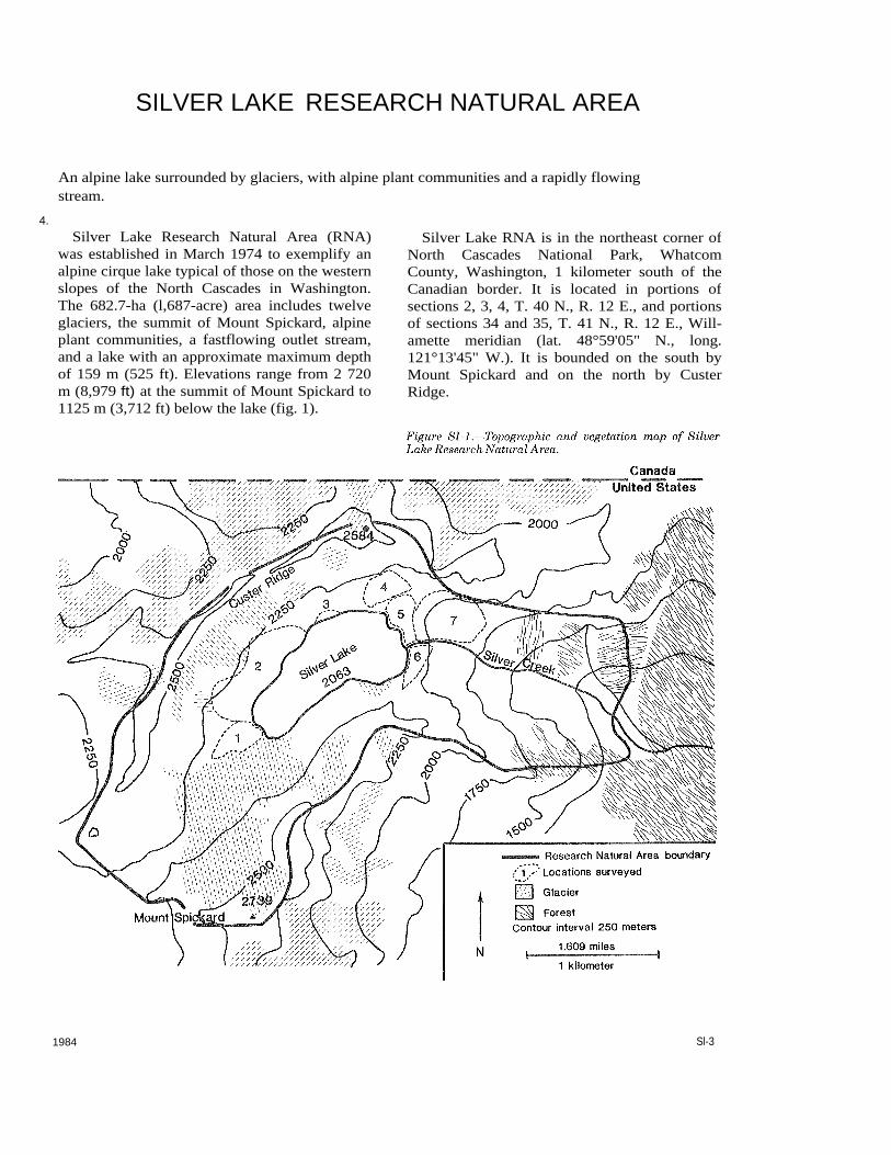
SILVER LAKE RESEARCH NATURAL AREA
An alpine lake surrounded by glaciers, with alpine plant communities and a rapidly flowing stream.
Silver Lake Research Natural Area (RNA) was established in March 1974 to exemplify an alpine cirque lake typical of those on the western slopes of the North Cascades in Washington. The 682.7-ha (l,687-acre) area includes twelve glaciers, the summit of Mount Spickard, alpine plant communities, a fastflowing outlet stream, and a lake with an approximate maximum depth of 159 m (525 ft). Elevations range from 2 720 m (8,979 ft) at the summit of Mount Spickard to 1125 m (3,712 ft) below the lake (fig. 1).
Silver Lake RNA is in the northeast corner of North Cascades National Park, Whatcom County, Washington, 1 kilometer south of the Canadian border. It is located in portions of sections 2, 3, 4, T. 40 N., R. 12 E., and portions of sections 34 and 35, T. 41 N., R. 12 E., Will-amette meridian (lat. 48°59'05" N., long. 121°13'45" W.). It is bounded on the south by Mount Spickard and on the north by Custer Ridge.
1984 Sl-3
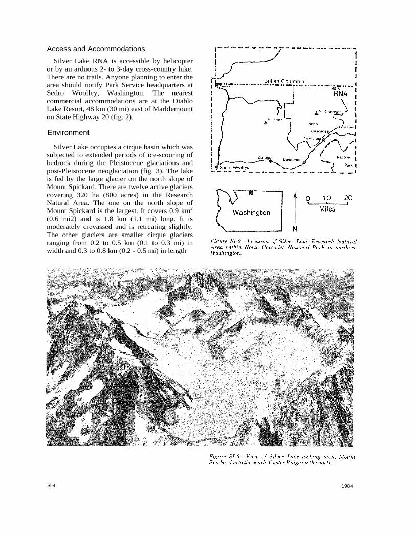
Access and Accommodations Silver Lake RNA is accessible by helicopter
or by an arduous 2- to 3-day cross-country hike. There are no trails. Anyone planning to enter the area should notify Park Service headquarters at Sedro Woolley, Washington. The nearest commercial accommodations are at the Diablo Lake Resort, 48 km (30 mi) east of Marblemount on State Highway 20 (fig. 2).
Environment
Silver Lake occupies a cirque basin which was subjected to extended periods of ice-scouring of bedrock during the Pleistocene glaciations and post-Pleistocene neoglaciation (fig. 3). The lake is fed by the large glacier on the north slope of Mount Spickard. There are twelve active glaciers covering 320 ha (800 acres) in the Research Natural Area. The one on the north slope of Mount Spickard is the largest. It covers 0.9 km2
(0.6 mi2) and is 1.8 km (1.1 mi) long. It is moderately crevassed and is retreating slightly. The other glaciers are smaller cirque glaciers ranging from 0.2 to 0.5 km (0.1 to 0.3 mi) in width and 0.3 to 0.8 km (0.2 - 0.5 mi) in length
Sl-4 1984

and varying in number of crevasses. All glaciers are stationary, and the source of snow and ice accumulation is direct snowfall and minor snowdrift (Post and others 1971).
Silver Lake is unusually deep for a lake with such a small surface area-0.16 kmP
2P (0.26 miP
2P).
Table 1 shows how it compares with other lakes in the United States. The continental ice sheet around Silver Lake may have reached up to 2121 m (7,000 feet) in this area, but around Silver Lake alpine glaciers were more prominent. The extreme depth of Silver Lake is the result of extensive, erosive action by these alpine glaciers.
Daly (1912) mapped the area around Silver Lake in 1904 and 1905, but the lake was not shown on the map he published in 1912. Ice is shown extending into the area now occupied by the northeast end of the present lake. A 1:62,500-scale topographic map published by the U.s. Geological Survey in 1913 shows Silver Lake (then known as Glacier Lake) with about one third of its present surface covered by the Mount Spickard Glacier.
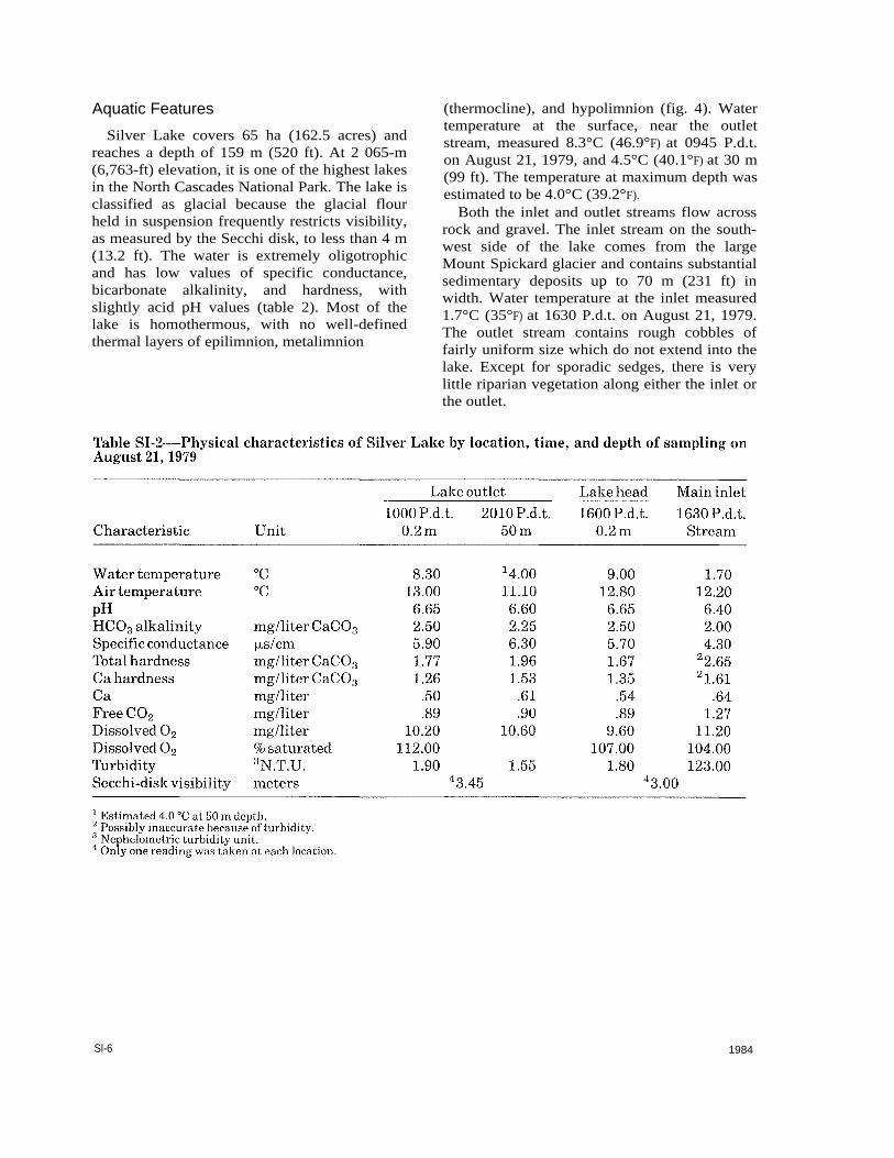
Aquatic Features Silver Lake covers 65 ha (162.5 acres) and
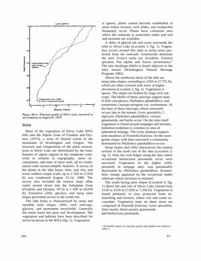
reaches a depth of 159 m (520 ft). At 2 065-m (6,763-ft) elevation, it is one of the highest lakes in the North Cascades National Park. The lake is classified as glacial because the glacial flour held in suspension frequently restricts visibility, as measured by the Secchi disk, to less than 4 m (13.2 ft). The water is extremely oligotrophic and has low values of specific conductance, bicarbonate alkalinity, and hardness, with slightly acid pH values (table 2). Most of the lake is homothermous, with no well-defined thermal layers of epilimnion, metalimnion
(thermocline), and hypolimnion (fig. 4). Water temperature at the surface, near the outlet stream, measured 8.3°C (46.9°F) at 0945 P.d.t. on August 21, 1979, and 4.5°C (40.1°F) at 30 m (99 ft). The temperature at maximum depth was estimated to be 4.0°C (39.2°F).
Both the inlet and outlet streams flow across rock and gravel. The inlet stream on the south-west side of the lake comes from the large Mount Spickard glacier and contains substantial sedimentary deposits up to 70 m (231 ft) in width. Water temperature at the inlet measured 1.7°C (35°F) at 1630 P.d.t. on August 21, 1979. The outlet stream contains rough cobbles of fairly uniform size which do not extend into the lake. Except for sporadic sedges, there is very little riparian vegetation along either the inlet or the outlet.
Sl-6 1984
Biota Most of the vegetation of Silver Lake RNA
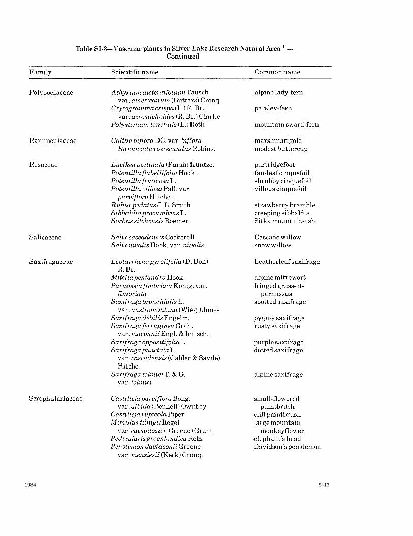
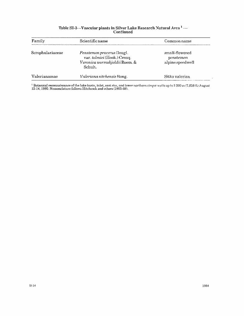
falls into the Alpine Zone of Franklin and Dyr-ness (1973), a zone of limited extent in the mountains of Washington and Oregon. The structure and composition of the plant associa-tions at Silver Lake are determined by the basic features of alpine regions in the temperate zone-wind in relation to topography, snow ac-cumulation, and time of snow melt, all in combi-nation with various edaphic features. A survey of the plants in the lake basin, inlet, east rim, and lower nothern cirque walls, up to 2 320 m (7,656 ft) was conducted August 12-14, 1980. The survey also included the eastern slope ofthe outlet stream down into the Subalpine Zone (Franklin and Dyrness 1973) at 1 830 m (6,039 ft). Extensive cliffs, glaciers, and steep talus slopes prevented access to the south rim.
The lake basin is characterized by steep and unstable talus slopes, cliffs, rock outcrops, glaciers, and permanent snowfields. Generally the entire basin has poor soil development. The vegetation and habitats have been described for seven locations in the RNA (fig. 1). Vegetation
1984
is sparse; plants cannot become established in areas where erosion, rock slides, and avalanches frequently occur. Plants have colonized sites where the substrate is somewhat stable and soil and moisture are available.
A delta of glacial silt and scree surrounds the inlet to Silver Lake (Location 1, fig. 1). Vegeta-tion occurs around this inlet in moist areas pro-tected from the outwash. Graminoids dominate the area: Festuca ouina var. breuifolia, Trisetum spicatum, Poa alpina, and Juncus mertensianus.5The rare Saxifraga debilis is found adjacent to the inlet stream (Washington Natural Heritage Program 1982).
Above the northwest shore of the lake are steep talus slopes, extending to 2350 m (7,755 ft), which are often covered with snow at higher elevations (Location 2, fig. 1). Vegetation is sparse. The slopes are broken by large rock out-crops. The bluffs of these outcrops support mats of Salix cascadensis, Phyllodoce glanduliflora, and sometimes Cassiope tetragona var. saximontana. At the base of these outcrops, where snowmelt occurs late in the season, Carex spectabilis, C. nigricans, Phyllodoce glanduliflora, various graminoids, and herbs occur. On the talus itself vegetation is found around seepages and streams. Epilobium latifolium is common in sites of ephemeral seepage. The rocky plateaus support lush meadows of Potentilla fruticosa. On the more gentle slopes with later snowmelt a community dominated by Phyllodoce glanduliflora occurs
Steep slopes and cliffs characterize the eastern section of the north rim of the lake (Location 3, fig. 1). Only the rock ledges along the lake where occasional herbaceous perennials occur were surveyed. Vegetation of the higher cliffs,primarily in seepage sites, was presumably dominated by Phyllodoce glandulifiora. Krumm-holz clumps appeared on the occasional stable substrate where moisture is retained.
The south-facing talus slopes (Location 4, fig. 1) above the east rim of Silver Lake extend from 2130 to 2230 m (7,029 to 7,359 ft). Vegetation is found primarily in sites protected from av-alanching and erosion, where soil and water ac-cumulate. Vegetation mats on these areas are composed of Potentilla fruticosa, Carex spectabilis, Salix niualis, Silene acaulis, graminoids and herbaceous perennials.
Sl-7
5 Scientific names of vascular plants and authors are listed in table 3.

A bench along the east rim north of the outlet, about 30 m (100 ft) above the lake (Location 5, fig. l), is primarily a fell-field with boulders (fig. 5). An extensive boulder field covers the west slope down to the lake shore. Sprawling, low-growing shrubs inhabit the fell-field: Juniperus communis, Arctostaphylos uva-ursi, Penstemon davidsonii, and Potentilla fruticosa. Pinus albicaulis, Abies lasiocarpa and Picea engelmannii grow in krummholz clumps along the east flank of the bench. Lichens grow on the rocks.
Vegetation along the east rim south of the outlet stream is sparse (Location 6, fig. 2). Thearea is characterized by a bench of fell-fields and boulder fields, barren talus slopes to the east, and terraced cliffs on the west slope down to the lake shore. Empetrum nigrum is the dominant shrub found in rocky, exposed sites. Salix nivalis forms vegetative mats in rockier and more exposed sites than those inhabited by Empetrum nigrum. Various heather communities occur in the more protected sites with accumulated soil.
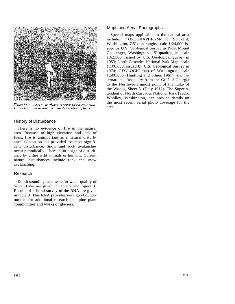
The east-facing slope north of the outlet stream is barren, with only a few refuge areas for plants (Location 7, fig. 1). Heather communities grow on sites of higher ground and better drainage (fig. 6). Sedge meadows of Carex spectabilis and/or C. nigricans occur where snowmelt is late. Seepage areas at higher eleva-tions are dominated by lush carpets of moss, Saxifraga tolmiei, and Luzula piperi. Abies lasiocarpa, growing as krummholz, occupies steeper parts of the slope in well drained sites (fig. 7).
Sl-8 1984
Maps and Aerial Photographs
Special maps applicable to the natural area include: TOPOGRAPHIC-Mount Spickard, Washington, 7.5' quadrangle, scale 1:24,000 is-sued by U.S. Geological Survey in 1969; Mount Challenger, Washington, 15' quadrangle, scale 1:62,500, issued by U.S. Geological Survey in 1953; North Cascades National Park Map, scale 1:100,000, issued by U.S. Geological Survey in 1974; GEOLOGIC-map of Washington, scale 1:500,000 (Huntting and others 1961); and In-ternational Boundary from the Gulf of Georgia to the Northwesternmost point of the Lake of the Woods, Sheet 5, (Daly 1912). The Superin-tendent of North Cascades National Park (Sedro Woolley, Washington) can provide details on the most recent aerial photo coverage for the area.
81-9 1984
History of Disturbance There is no evidence of fire in the natural
area. Because of high elevation and lack of fuels, fire is unimportant as a natural disturb-ance. Glaciation has provided the most signifi-cant disturbance. Snow and rock avalanches occur periodically. There is little sign of disturb-ance by either wild animals or humans. Current natural disturbances include rock and snow avalanching.
Research
Depth soundings and tests for water quality of Silver Lake are given in table 2 and figure 1. Results of a floral survey of the RNA are given in table 3. This RNA provides very good oppor-tunities for additional research in alpine plant communities and works of glaciers.
SI-10 1984

1984 81-11
81-12 1984
1984 Sl-13
Sl-14 1984
Literature Cited
Bue, C. D. Principal lakes of the United States. Geological Survey Circular 476. U.S. Department of the In-terior, U.S. Geological Survey. Washington D.C.: 1963. 22 p.
Daly, R. E. Geology of the North American Cordillera at the forty-ninth parallel. Memoir No. 38, Part I. Map 88A. Ottawa, Canada: Geological Survey of Canada, 1912.
Franklin, Jerry F. and Dyrness, C. T. Natural vegetation of Oregon and Washington . Gen. Tech. Rep. PNW-8. Portland, OR: U.S. Department of Agriculture, Forest Service, Pacific Northwest Forest and Range Experiment Station. 1973.417 p.
Hitchcock, C.; Cronquist, A.; Ownbey, M.; and Thompson, J. W.
Vascular plants of the Pacific Northwest: 5 Vol-umes. Seattle, WA; University of Washington Press; 1955-69.
Huntting, Marshall T.; Bennett, W.A.G.; Livingston Jr., Vaughan E.; and Moen, Wayne S.
Geologic map of Washington. Olympia, WA: Washington Department of Natural Resources, Division of Geology and Earth Resource. 1961.
Post, Austin; Richardson, Don; Tangfour, Wendell V.; Rosselot, F. L.
Inventory of glaciers in North Cascades, Washington. Prof. Paper 705-A. Washington, D.C.: Department of the Interior, U.S. Geological Survey. 1971. 26 p.
Washington Natural Heritage Program. Endangered, threatened, and sensitive vascular plants of Washington. Olympia, W A: Department of Natural Resources. 1982.25 p.
1984 Sl-15