sedimentation history of waipaoa catchment envirolink ... · waipaoa catchment envirolink project...
TRANSCRIPT

Sedimentation History of Waipaoa Catchment
Envirolink project 1015-GSDC96


Sedimentation History of Waipaoa Catchment
Envirolink project 1015-GSDC96
Mike Marden,
Landcare Research
Prepared for:
Gisborne District Council
15 Fitzherbert Street P.O Box 747 Gisborne 4040 New Zealand
September 2011
Landcare Research, ZG FM Building, Grey Street, PO Box 445, Gisborne 4040, New Zealand, Ph +64 6 863 1345, Fax +64 6 863 1346, www.landcareresearch.co.nz

Reviewed by: Approved for release by:
Ian Lynn Soil Scientist Landcare Research
Craig Ross Acting Science Team Leader Soils and Landscape Responses
Landcare Research Contract Report: LC 790
© Landcare Research New Zealand Ltd 2011
This information may be copied and distributed to others without limitation, provided Landcare Research New Zealand Ltd and the source of the information are acknowledged. Under no circumstances may a charge be made for this information without the written permission of Landcare Research..

Landcare Research Page iii
Contents
Summary ..................................................................................................................................... v
Recommendations and future research needs ........................................................................ vii
1 Introduction ....................................................................................................................... 1
2 The Waipaoa River Catchment ......................................................................................... 2
3 Sediment sources .............................................................................................................. 4
3.1 Shallow landslides ............................................................................................................... 4
3.2 Earthflows ............................................................................................................................ 5
3.3 Gullies .................................................................................................................................. 6
3.4 Cliffs and river banks ........................................................................................................... 7
3.5 Aggraded riverbeds ............................................................................................................. 9
3.6 Slumps ............................................................................................................................... 10
3.7 Slopewash .......................................................................................................................... 11
4 Evolution of the Waipaoa catchment and sedimentation history of Poverty Bay ......... 11
5 Post-settlement erosion and sediment contribution to sediment yield......................... 13
6 The role of forest vegetation in mitigating erosion processes ....................................... 14
7 Effectiveness of past erosion mitigation efforts ............................................................. 15
7.1 Shallow landslides ............................................................................................................. 15
7.2 Earthflows ......................................................................................................................... 17
7.3 Gullies ................................................................................................................................ 18
7.4 River banks and cliffs ......................................................................................................... 19
7.5 Aggraded river beds .......................................................................................................... 19
7.6 Slopewash .......................................................................................................................... 20
8 Modelled reductions in sediment yield following reforestation .................................... 20
8.1 Sediment from harvested areas of exotic forest ............................................................... 22
Envirolink project 1015-GSDC96
Page iv Landcare Research
9 Off-site benefits of sediment reduction .......................................................................... 23
9.1 Protection of infrastructure .............................................................................................. 23
9.2 Stream health .................................................................................................................... 23
9.3 Best Management Options ................................................................................................ 25
9.4 Fencing waterways and establishing riparian plantings .................................................... 25
9.5 Reversion ........................................................................................................................... 26
9.6 Natural and constructed wetlands .................................................................................... 27
9.7 Debris dams/stock ponds .................................................................................................. 28
9.8 Culverts/bridging of stream crossings ............................................................................... 28
9.9 Reforestation/soil conservation planting .......................................................................... 28
9.10 Floodplains and estuaries as sediment traps .................................................................... 31
10 Prioritisation of areas for best management options (BMPs) ........................................ 31
11 Impact of climate change on hill country erosion ........................................................... 32
11.1 Implications from process studies ..................................................................................... 33
12 Conclusions ...................................................................................................................... 35
13 Recommendations and future research needs ............................................................... 37
14 Acknowledgements ......................................................................................................... 38
15 References ....................................................................................................................... 38

Landcare Research Page v
Summary
Project and Client
Gisborne District Council requested a literature review of the pre- and post-human
settlement erosion and sedimentation rates in Waipaoa catchment. By assessing the
proportion of sediment derived by erosion processes considered to be part of the natural
background erosion rates versus that induced essentially since the clearance of
indigenous forest for pastoral farming, the Council seeks to better understand where
and how improved land management and remediation practices could potentially result
in a reduction in sedimentation. Information from this report will be provided to the
Fresh Water Advisory Group and used to assess effective management strategies for
managing sedimentation in the Waipaoa Catchment.
The reports objectives are to:
collate and review existing literature relevant to establishing sedimentation rates pre-
and post-human settlement
provide an account of the relative contributions of sediment derived by the different
erosion processes identified in the Waipaoa catchment
summarise the causal factors and scientific evidence explaining the increase in erosion
and sedimentation following human settlement.
provide an assessment of the effectiveness of past erosion control efforts in reducing
sediment generation and delivery to streams
provide modelling results showing potential future trends in sediment production with
and without further erosion control treatment of erosion-prone parts of the landscape
provide examples of best management practices that could be used to mitigate sediment
input into Waipaoa River, their effectiveness and any associated benefits in overall
stream health
indicate the implications of climate change on erosion and sedimentation in Waipaoa
catchment.
Conclusions
The relative contributions of sediment derived from different sources have changed
over time and in response to different drivers including tectonics, climate and more
recently, deforestation. Prior to human settlement channel incision, shallow and deep-
seated landslides were the major processes that delivered sediment to stream channels.
Following deforestation, gully erosion and shallow landsliding dominate the present-
day sediment budget of the Waipaoa River.
The present day sedimentation problem in the Waipaoa catchment is of historical origin
and can be attributed directly to the dramatic increase in hill slope erosion following
clearance of the indigenous forest from erosion-prone terrain during the early European
settlement period. The delivery of sediment to the main channels of the Waipaoa and
Mangatu river’s, primarily from gullies, exceeded the rate at which these rivers could
transport the material and hence it accumulated in these channels. This legacy of stored

Envirolink project 1015-GSDC96
Page vi Landcare Research
sediment together with ongoing sediment delivery from existing, untreated gullies and
from shallow landslides during periodic storm events, has the greatest, long-term, on-
site (loss of soil depth and productive capacity) and off-site (sedimentation and
flooding) environmental impact. Although other sediment-generating processes,
including earthflows, slumps, bank and cliff erosion and slopewash, can at times be
significant sources they tend to be localised and ‘event driven’ and their contribution,
relative to gullies and shallow landslides, is small and short term.
Geology (rock type, induration, regolith composition, drainage and permeability), uplift
rates, and climate (rainfall amounts and intensities, frequency of large storms) largely
determine the landscape’s inherent susceptibility to erosion, including the response to
vegetation change. Susceptibility to erosion is readily identifiable at a regional scale
and increasingly tools and methods are becoming available that can be used at hillslope
and farm scale. Large, high-magnitude, low-frequency storms or long wet periods drive
mass movement erosion (landslide, earthflow) on hillslopes. For fluvial erosion
(gullying, bank and channel erosion) the smaller more frequent storms are more
important (i.e. low-magnitude, high-frequency events). Earthquakes are a significant
driver for deep-seated mass movements and are much lower frequency events.
Closed-canopy woody vegetation reduces rates of hillslope erosion by an order of
magnitude on the most susceptible terrain. Past vegetative erosion control efforts
through reforestation, reversion and pole planting have proved successful for
controlling much erosion. However, the use of pole planting for the treatment of large
and active mass movement features (earthflow and slump) and gully erosion, in the
most highly erodible terrains, has had only limited success. Space-planted poles can
provide protection against the initiation of shallow landslides if planted in sufficient
numbers and in the appropriate position on slopes. The encouragement of natural
reversion and/or the establishment of riparian vegetation ‘strips’ as a means of reducing
sediment input into streams has its limitations in hill country terrain dominated by mass
movement failures, as the mobilised and often ‘liquid-like’ sediment tends to be
transported through all but the densest vegetation barriers. Nonetheless, streamside
vegetation can be an effective barrier to sediment (derived either by mass movement or
slopewash), nutrients and animal pathogens in situations where alluvial terraces act as a
buffer between the stream and a hill slope and the terraces are elevated above high
flood level.
Further planting of all remaining gullies, earthflows and of terrain identified as having a
high potential for shallow landsliding is required if further sediment input into Waipaoa
river is to be minimised. The reforestation of gullies is the most practical and effective
means of stabilising all but the largest gullies. If all remaining untreated gullies in each
of the three major catchments were to be reforested before 2020, and no new gullies
were initiated during this period, gully-derived sediment yield could be halved by 2030
and would remain constant thereafter. A modelled reforestation strategy aimed at
prioritising land for reforestation according to landslide susceptibility could have a
significant impact on fine sediment yields. With prioritisation, a 40% reduction in
landslide-derived sediment could be achieved through reforestation of 8% of the
Waipaoa River catchment, whereas 25% of the land would need to be reforested to
achieve the same effect through random selection. Sediment yields from other sources,
including earthflows, stream banks and reworked material in temporary storage as
bedload could be considered as being of lesser concern.
Envirolink project 1015-GSDC96
Landcare Research Page vii
Following reforestation, streams within mature plantation forests have greater stability
and lower water temperature than adjacent pastoral streams, resulting in improved
overall stream ecological health approaching the condition of reference streams in
native forest. Reductions in sediment input and improvements in stream health are
possible at a localised scale and within a relatively short time frame but are unlikely to
make a significant difference to the sediment load or water quality of the Waipaoa
River as a whole for many decades, if not millennia. Without further erosion mitigation
intervention and in the event of more severe storm events, erosion on unprotected hill
slopes will increase and further exacerbate the current sedimentation issues of the
Waipaoa catchment.
For sediment management to be effective and sustainable the fundamental unit of
management should be the whole river basin. This introduces some important issues. It
is necessary to recognise the numerous environments within a river basin (including
soils/hillslopes, rivers, floodplains, wetlands, lakes/reservoirs and the coastal zone ),
and the interconnectivity between these environments. The interconnection between
land-use changes on hillslopes, sediment delivery and transport in rivers, and sediment
deposition and flooding in downstream reaches has been demonstrated for the Waipaoa
River (Owens et al. 2004). This study illustrated the potential for targeted management
in headwater reaches to control downstream problems (i.e. controlling the source of the
problem as opposed to downstream management). Second, there is a need for a greater
understanding of how the processes that control sediment generation, delivery and
transport within rivers operate at scales that are meaningful for management and based
on this the means of identifying which remediation strategies could provide a reduction
in sediment generation from hillslopes and where to apply them.
The impacts of pre- and post-European deforestation have persisted for more than a
century. Climate change is likely to exacerbate erosion problems and lead to increased
sedimentation since it is predicted to cause heavier and/or more frequent extreme
rainfalls.
Recommendations and future research needs
In view of the potential worsening of hill slope erosion and its impact on sedimentation
patterns within the Waipaoa River, it is recommended that the Gisborne District
Council use Snelder et al.’s (2005) River Environmental Classification (REC) as a
spatial framework for mapping and classifying rivers or reaches within the catchment
into classes discriminated by variations in physical (land cover, geology, climate,
topography) and biological (water chemistry, biological communities) characteristics
at a range of scales. The REC classes can be treated as management units, each of
which can be linked to a monitoring strategy and used as a framework for
environmental assessment, management and reporting.
Use existing data to establish the current ‘base level’ of suspended sediment yield from
monitored sub-catchments, and based on this use prediction tools/models to prioritise
sub-catchments/parts of sub-catchments according to where the greatest gains in
sediment reduction might be possible if mitigation measures were to be implemented.

Envirolink project 1015-GSDC96
Page viii Landcare Research
Develop appropriate erosion mitigation implementation plans targeting existing, active
sediment sources (e.g. gullies) first, then future proof vulnerable areas (e.g. steep hill
slopes, stream banks) through further tree planting (poles, reversion and/or forestry).
A survey of regional councils, industry, central government agencies and science
providers identified a wide variety of research needs to assist improved management of
hill country erosion and resultant sedimentation. Gaps identified by the greatest number
of stakeholders included: (from Basher et al. 2008)
ability to measure regional/catchment rates of erosion and determine what is
tolerable, including measuring the contribution from different land uses and
land management practices, being able to distinguish natural and induced
erosion, and the contribution of different processes
integrated research on sediment dynamics (connectivity and lags) within
catchments and downstream effects, including slope–channel linkages
development of erosion prediction tools/models incorporating land
use/management effects and able to distinguish different erosion processes
effectiveness of space-planted trees (including willows, poplars and natives) for
erosion control and their management requirements, and other erosion control
measures, over a range of event magnitudes
cost–benefit analysis of different mitigation techniques including co-benefits of
erosion control on carbon storage, role of erosion in the carbon budget
effective community engagement processes for erosion and catchment
management, and improved technology transfer.
Envirolink project 1015-GSDC96
Landcare Research Page 1
1 Introduction
One of the most dramatic examples of landscape response to environmental disturbance by
humans can be found in the East Coast Region, North Island, New Zealand. In the brief
European settlement history of this region (from ~1860s) the greatest impact has been the
widespread initiation and development of erosion following clearance of mature indigenous
forest for pastoral farming (Allsop 1973; Gage & Black 1979). Concern over accelerated
erosion induced by human activity has generated a substantial literature (Campbell 1946;
NWASCO 1970; Jones & Howie1970; Eyles 1985). Several recent studies have highlighted
the erosion response to land-use change, sediment generation processes and river channel
sedimentation (Marutani et al. 2001; Owens et al. 2005; Liebault et al. 2005; Page et al. 2008;
Hicks et al. 2011).
Equally dramatic has been the implementation of restorative efforts, principally reforestation,
and other soil conservation strategies on eroding pastoral hill country and its success in
effectively treating erosion and slowing the delivery of sediment to stream channels. There
are few documented cases where land-use change from indigenous forest to pasture followed
by the re-establishment of a forest cover for erosion control has occurred over such an
extensive area and in a timeframe measurable in decades rather than in centuries.
This short but dramatic change in land use has left a legacy of problems associated with
extensive sedimentation within river channels including increased risk of flooding, degraded
stream ecology and water quality issues. Sediment has been identified as a major contaminant
affecting freshwater (Parkyn et al. 2002; Davies-Colley et al. 2003) and is the single biggest
stressor to the marine environment (Morrison et al. 2009). Managing the freshwater effects
relies on managing sediment generation from the land.
A requirement of the National Policy Strategy for Freshwater Management is for Gisborne
District Council to set appropriate water quality standards as part of a proposed Gisborne
District Water Plan for the Waipaoa Catchment. In view of the susceptibility of the soft rock
lithologies comprising this catchment, with consequent very high suspended sediment yields,
it is important to establish a ‘base level’ for what could be considered ‘natural’ background
(pre-human) yields. This requires an understanding of the history of erosion, the causal
factors and processes that produce sediment, together with knowledge of those mitigation
measures that afford effective restoration and thereby offer potential solutions to manage, if
not to reduce, sedimentation levels.
With a focus on the Waipaoa River this report:
collates and reviews existing literature relevant to establishing sedimentation rates pre-
and post-human settlement
provides an account of the relative contributions of sediment derived by the different
erosion processes identified in the Waipaoa catchment
summarises the causal factors and scientific evidence explaining the increase in erosion
and sedimentation following human settlement.
provides an assessment of the effectiveness of past erosion control efforts in reducing
sediment generation and delivery to streams

Envirolink project 1015-GSDC96
Page 2 Landcare Research
provides modelling results showing potential future trends in sediment production with
and without further erosion control treatment of erosion-prone parts of the landscape
provides examples of best management practices that could be used to mitigate
sediment input into Waipaoa River, evidence of their effectiveness, and associated
benefits in overall stream health
indicates the implications of climate change on erosion and sedimentation in the
Waipaoa catchment.
2 The Waipaoa River Catchment
The Waipaoa River (Fig. 1) drains an area of about 2205 km2
on the North Island of New
Zealand, flowing south-eastward from the Raukumara Range and discharging to Poverty Bay
(Hicks et al. 2000). The watershed is located in the forearc region of the Hikurangi Margin,
where the Pacific Plate is subducting obliquely westward beneath the Australian Plate. The
river has incised into uplifted and variously deformed, jointed and clay-rich marine
sedimentary rocks of Cretaceous to Pliocene age (Fig.2) (Mazengarb & Speden 2000) that are
predisposed to mass movement, gullying and mechanical disintegration under the influence
of water and to acid sulphate weathering (Pearce et al. 1981).
Figure 1 Location map of Waipaoa catchment

Envirolink project 1015-GSDC96
Landcare Research Page 3
Superimposed on this bedrock base are remnants of four Quaternary-aged alluvial terraces,
each of which represents floodplain aggradation during a cool glacial period (Berryman et al.
2000; Eden et al. 2001; Marden et al. 2008a) and seven levels of alluvial terrace that formed
since the Last Glacial Maximum (Marden et al. 2010). Over the past 18 000 years a mantle
of volcanic ash, derived from the Taupo and Okataina Volcanic centres ~150 km to the west,
has blanketed both the alluvium and sedimentary rocks of the Waipaoa catchment to several
meters thickness, and serves as the foundation for many of its soils.
Figure 2 Distribution of lithologies within Waipaoa and Waimata catchments. The dark grey area in the
headwater reaches (8% of catchment area) is underlain with Cretaceous-aged lithologies prone to mass
movement (earthflow and slump) and gullying. The light grey area in the mid and lower reaches (78% of
catchment area) is underlain with Miocene to Pliocene-aged lithologies more prone to shallow landsliding.
Elsewhere in this document these areas are referred to as the Cretaceous and Tertiary terrains, respectively.
The climate is warm temperate maritime, with warm moist summers and cool wet winters.
Rainfall gradients increase from the coast to inland areas. Mean annual rainfall for coastal
areas in the south (Gisborne City) is 1200 mm, while inland areas receive ~2500 mm (Hessell
1980). The region’s climate is strongly influenced by the El Niño/Southern Oscillation
(ENSO), with an increase in major rainfall events during La Niña conditions and severe and
prolonged droughts during El Niño years. Tropical cyclones during the summer months
(November–March) have on occasion accelerated erosion, the last being in 1988 (Cyclone
Bola). In the Waipaoa catchment there is a 29% chance of a major event every year, and a

Envirolink project 1015-GSDC96
Page 4 Landcare Research
greater than 99% chance one will occur every 10 years (Kelliher et al. 1995). This volatile
climate contributes to high erosion rates (Water and Soil Directorate 1987).
Current vegetation cover in hill country areas comprises pasture (70%), exotic forest (20%),
indigenous forest (6%), and bare ground (4%). Before Maori (~600 yr BP) and European
(commencing in the 1820s) settlement, the East Coast region was almost completely
vegetated with podocarp/hardwood (mainly conifer) forest in the lowlands, Nothofagus forest
at higher altitudes, and alpine-subalpine shrub land and grasslands on the highest parts of the
axial ranges (McGlone 1988; Wilmshurst 1997).
Deforestation of the watershed, primarily by burning, commenced in its lower reaches with
the arrival of Polynesian (Maori) settlers around 700 years ago and extended into the
headwater reaches following European settlement (Pullar 1962; McGlone et al. 1994;
McGlone & Wilmshurst, 1999 Wilmshurst et al. 2008). Much of the lowland had been
deforested by 1875 (Murton 1968) and by the late 1920s 97.5 % of the old-growth native
forests had been destroyed (Gomez et al. 1999).
Early photographs (c. 1903–1910) show that the landscape revealed by the clearance of forest
had been subjected to mass movement in the past, a process that has continued since at least
the end of the last glacial period and throughout the Holocene (~ 18 000 years). Accounts of
the early onset of erosion in the Waipaoa catchment since settlement are obscure. Anecdotal
evidence suggests it was likely initiated within a decade or two following the clearance of
indigenous forest beginning in the late 1800s with early observations of extensive landsliding
in the hill country during the winters of 1883 and 1894. During the first decade of the 20th
century there followed a period of geomorphic slope adjustment in response to the removal of
this forest (Hill 1895; Henderson & Ongley 1920), the most noticeable being the initiation of
mass movement (earthflows and slumps) and associated gullying. Erosion was precipitated
by changing soil moisture conditions, the pattern of hillslope runoff (from subsurface, diffuse
drainage to surface runoff and its concentration along preferred drainage channels) and the
loss of root strength that lowered the threshold for their development (O’Loughlin 1974a,b).
Erosion, and gully erosion in particular, had a noticeable effect on river channel aggradation
(Kennedy 1912; Allsop 1973; Gage & Black 1979), and in headwater streams the cobble-
sized bed material had been replaced by fine gravel and sand (Kelman, undated; Laing-
Meason 1914; Jones & Howie 1979; Black 1977) leading to an estimated 6.5-fold increase in
suspended sediment discharge of the Waipaoa River (Kettner et al. 2007).
The combination of highly erodible, steep and jointed bedrock, tephric soils and alluvium,
episodically intense precipitation, seismic activity, and human disturbance contribute to rapid
erosion of the Waipaoa watershed, and one of the highest suspended sediment yields in the
world (7216 tons km–2
yr–1
; Hicks et al. 2011).
3 Sediment sources
3.1 Shallow landslides
Shallow landsliding (Fig 3) is defined as the movement of soil/or subsoil to expose a slip
surface that is approximately parallel to the original slope. It is the dominant mode of
sediment generation and delivery over much of the middle and lower watershed, where more

Envirolink project 1015-GSDC96
Landcare Research Page 5
competent Miocene-Pliocene sandstone, mudstone, and minor limestone underlie the hill
slopes (78% of catchment area) (Reid & Page 2003; Hicks et al. 2004; Marden et al. 2008b).
Landsliding is triggered during lower-frequency, higher magnitude storms that occur with
typical decadal return periods (Hicks et al. 2000; Reid & Page 2003; Hicks et al. 2004). Slope
failure tends to occur at less than one metre, but where surficial coverbeds are thicker failure
often occurs at the bedrock-soil interface at depths up to two metres and mobilizes generally
sandy, pumiceous material (Preston & Crozier 1999).
Figure 3 Shallow landsides initiated on steep pasture slopes in the Ngatapa area following a storm in July 1985.
3.2 Earthflows
Earthflows (Fig 4) are described as the downslope movement of soil and rock, involving a
large quantity of water. The ratio of soil to water causes the material to behave like a liquid.
When soil moisture conditions become ‘wet’ and remain so for long periods (months) they
mobilise at glacier–like pace interspersed with surge-like displacements in increments of
metres to tens of metres in a day (Marden et al. 2008c). Displacement of material occurs
through sliding along an internal and planar shear surface of depths between 0.5 and 6 m
below ground surface. Most earthflows are associated with slopes of 5–25 degrees. During
dry periods they remain stable for long periods of time (decades to centuries).

Envirolink project 1015-GSDC96
Page 6 Landcare Research
Figure 4. Wether Run earthflow, Mangatu Forest, before reforestation.
3.3 Gullies
Accelerated erosion by gullying (Fig. 5) is a major source of sediment in steepland
catchments. Gully and associated mass movement erosion is most prevalent in crushed
argillite and mudstone underlying the basin headwaters (~ 8% of the total catchment area)
and is currently the primary source of fine-grained sediment to the system (Hicks et al. 2004;
Marden et al. 2008b). Studies of the morphology and development of gullies (relatively deep
and rapidly eroding channels) suggest they have a limited lifespan and rapidly evolve to a
condition of relative stability. Some gullies appear to be a natural component of landscape
evolution, but many contemporary gullies formed after native forests were cleared and
agriculture intensified in the 19th
and 20th
centuries (Ireland et al. 1939). In either case, gully
extension represents a major adjustment to the landscape that is imprinted on the drainage
network and has a profound impact on basin sediment yield. As gullies are part of and thus
directly connected with the drainage network, sediment supply from them dominates even
during high-frequency, low magnitude rainfall events (<1 yr return period; Hicks et al. 2004).

Envirolink project 1015-GSDC96
Landcare Research Page 7
Figure 5 Example of a gully that was already too active and large at the time of planting for reforestation to
become an effective treatment. Sediment from this (Tarndale Gully) and all other gullies considered to be
‘active’ contribute sediment directly into the drainage system.
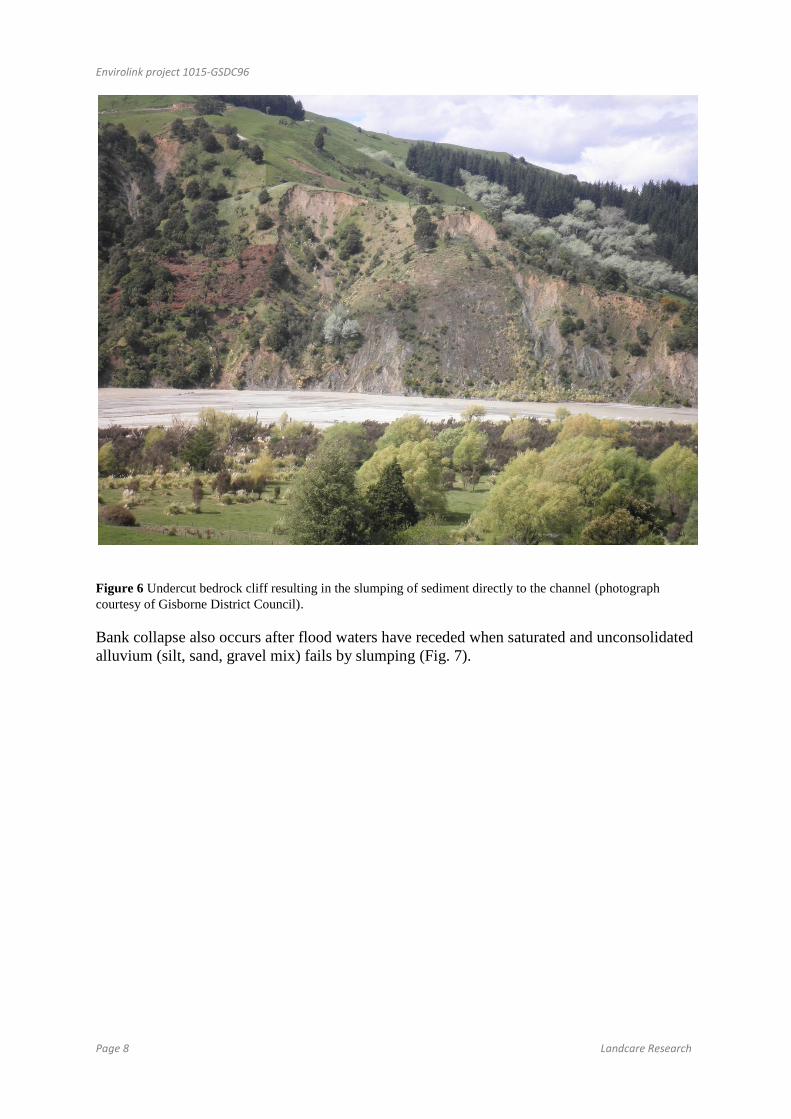
3.4 Cliffs and river banks
Cliff and bank erosion is the removal of material along a permanent course by the action of
flowing water. This normally involves the undercutting of the bank (generally unconsolidated
alluvium) or cliff (generally more consolidated bedrock) resulting in the collapse of blocks of
material directly into the river (e.g., Fig. 6). Lateral and vertical erosion of cliffs and banks
occurs mainly during high peak flows (floods).
Envirolink project 1015-GSDC96
Page 8 Landcare Research
Figure 6 Undercut bedrock cliff resulting in the slumping of sediment directly to the channel (photograph
courtesy of Gisborne District Council).
Bank collapse also occurs after flood waters have receded when saturated and unconsolidated
alluvium (silt, sand, gravel mix) fails by slumping (Fig. 7).

Envirolink project 1015-GSDC96
Landcare Research Page 9
Figure 7 Bank consisting of unconsolidated alluvium that likely failed after flood waters receded (photograph
courtesy of Gisborne District Council).
3.5 Aggraded riverbeds
Significant amounts of sediment are stored within the stream system as bed load. In the
headwater reach of Mangatu and Waipaoa river aggradation has appreciably raised and
widened their respective channels, burying terraces which used to be former homestead sites.
In catchments draining soft rock that is mudstone dominated the bed load is overwhelmingly
dominated by smaller particle sized material (e.g. fine gravel, sand and silt). In other
catchments where the lithologies comprise harder material such as sandstone and limestone
their bed load comprises mainly cobble and boulder sized material with minor sand and silt.
Bed load, irrespective of its composition, breaks down into smaller particles as a consequence
of in-situ weathering processes (heating, cooling, wetting, drying etc) and attrition/abrasion
as it is transported along the streambed. These finer particles (silt and clay) are transported as
suspended sediment and during high flows is a significant component of total sediment load
Fig. 8).

Envirolink project 1015-GSDC96
Page 10 Landcare Research
Figure 8 An actively aggrading river bed in the headwater reach of the Waipaoa River. The pre-settlement bed
level is thought to lie ~20 m below the current bed level.
3.6 Slumps
These are rotational failures where displacement occurs at depth along a surface of rupture
that is curved concavely upward. Slumps (Fig. 9) combined with other types of slope failure
in the Waipaoa catchment have at one time or another over the past 18 000 years affected ~
18.5% of the hill slopes present in this and Waimata catchment (Page and Lukovic, 2011).
Extensive slumping occurred during the early settlement period, particularly in the headwater
areas now occupied by Mangatu Forest. More recently, slump failures have tended to occur
as temporally and spatially separated features with failure usually associated with heavy
rainfall events or earthquakes. Although slumping is currently uncommon in this catchment,
when they do fail they tend to connect with and hence deliver an initial and significant
volume of sediment to a stream channel. Slumps can result in the temporary blocking of a
channel. With time the channel cuts through the slump and often continues to deliver
sediment to the stream years after the initial failure.

Envirolink project 1015-GSDC96
Landcare Research Page 11
Figure 9 Isolated slump with stream undercutting along the toe slope contributing a small amount of sediment
to the stream channel with most of the displaced material remaining on-slope.
3.7 Slopewash
Slopewash sediment is derived from diffuse areas of bare ground within the pasture sward,
especially from steep areas where the pasture is heavily grazed or affected by drought. Farm
tracks, landslide scars, and debris tails are also sources of slopewash sediment. Slopewash
occurs by a combination of splash and surface water movement downhill. It usually occurs
when intense rainfall exceeds the infiltration capacity of the soil. Slopewash is less common
in standing forest than in areas of pasture and cleared forest. Slopewash can result in the
redistribution and delivery of organic matter, fine sediment, forest slash, nutrients, and faecal
microbes to stream channels.
4 Evolution of the Waipaoa catchment and sedimentation history of Poverty Bay
Since the late Quaternary there have been ten identifiable periods of extensive floodplain
aggradation. The cessation of each phase of aggradation was brought about when drainage
channels began to incise into their floodplain in response to variations in climate and regional
uplift (Berryman et al. 2000; Eden et al. 2001; Marden et al. 2008a. Thus periods of
floodplain aggradation alternated with periods of channel incision to leave abandoned
remnants of former floodplains as alluvial terraces. Seven of the alluvial terrace surfaces
identified in Waipaoa catchment have formed in the last 27 000 years, that is, since the Last
Glacial Maximum (Marden et al. 2010).
Sediment generated during periods of channel incision and by subsequent hill slope failures,
in response to a lowering of stream base level, formed the Poverty Bay floodplain. Channel
incision is thought to have primed hillslopes for failure through the oversteepening and
removal of slope support to produce12.1 cubic kilometres of sediment since the Last Glacial

Envirolink project 1015-GSDC96
Page 12 Landcare Research
Maximum (Marden et al. 2008a). This is about 42% of the estimated 28.6 km3 of sediment
stored in depositional sinks (Poverty Bay floodplain and offshore) with shallow landslides
producing 21%, deep-seated landslides (slumps) 8%, slopewash 3% and lake sediments
released by dam breaching 1% ( Page and Lukovic,2011).
Over the entire Holocene period (~last 10 000 years) up until extensive deforestation in the
19th
century the influx of suspended sediment to the coastal plain remained roughly constant
at ~2.7 Mt/year (Wolinsky et al. 2010); ~ 5 times less than the 15Mt /year at present. From
the distribution of dated tephra (volcanic ash) and palaeo-shorelines (Fig. 10), Pullar and
Penhale (1970) and Brown (1995) estimated that the shoreline has advanced seaward from its
maximum inland extent 7000–6000 years ago to its position 5000 years ago at a rate of 4
m/year, and during the period 5000–2000 years ago the rate of advance slowed to 1.3 m/year.
Over the last 2000 years this decreased further to 0.6 m/year (Gibb 1995). Wolinsky et al.
(2010) demonstrate that the slowing in coastal progradation is not the result of decreasing
sediment supply or increased subsidence of the Poverty Bay floodplain but rather is due to an
increase in accommodation space as the area of floodplain increased. This suggests that
baseline sedimentary processes (sediment supply, coastal subsidence, regional uplift) were
relatively constant prior to recent anthropogenic disturbance in the Waipaoa catchment. For
the post-deforestation period it is estimated that of the sediment stored in depositional sinks
(floodplain and offshore) since the Last Glacial Maximum, gullies have contributed 1%,
shallow landslides 1%, slopewash 0.2% and other processes combined (earthflow and
streambank erosion) 0.5% (Page and Lukovic,2011). Based on the high suspended sediment
yield currently discharged from Waipaoa River it is expected that the shoreline will continue
to advance well into the next century and beyond (Gibb 1995).
Figure 10 Evolution of the Poverty Bay shoreline over the last 7000 years (From Wolinski et al. 2010).
Envirolink project 1015-GSDC96
Landcare Research Page 13
5 Post-settlement erosion and sediment contribution to sediment yield
Estimates suggest that there has been at least an order-of–magnitude increase in erosion
within Waipaoa River as a consequence of anthropogenic deforestation and land use change.
For example, before deforestation the incidence of gully erosion within areas of indigenous
forest was low but soon became a pervasive feature on farmland with 99.5% of the total
composite area of all gullies present in 1957 being associated with areas of cleared land. It is
likely therefore that the majority of gullies were initiated subsequent to, and in response to,
forest clearance. The relative contribution of sediment derived by gully erosion is the
equivalent of ~ 43% of the annual suspended sediment yield of Waipaoa River (Marden et al.
2008b).
Similarly, the incidence of shallow landsliding before deforestation was likely negligible, as
it is today within remaining forested and reforested areas. Since deforestation the frequency
and extent of shallow landsliding have increased dramatically, with landslides contributing
~60% of the sediment yield of the Waipaoa river during floods but 10–20% overall (Reid &
Page 2003).
There has been no appreciable change in rates of cliff erosion over the past 18 000 years.
Bank and cliff erosion processes were likely relatively more important as a source of
sediment before widespread land-use conversion from native forest to pasture. In an
essentially pastoral land-use regime the contribution of sediment from bank and cliff erosion
(74.3 and 23.3 kt a –1
, respectively) to suspended sediment load is low (<2%) because the
Waipaoa river has a high specific load dominated by mass movement erosion (De Rose &
Basher 2011). Although Rosser (2007) found that bank-derived sediment from a 21-km
floodplain reach of Waikohu River during the 1952–2002 equated to ~8% of the total annual
suspended sediment yield of Waipaoa River most of it was generated during a single event on
Labour Weekend 2005. In contrast, the long-term records show that the entire Waikohu
catchment produces just 1.4% of the total annual suspended sediment of the Waipaoa River.
The contribution of sediment derived by slopewash has not been quantified for Waipaoa
catchment. Page et al. (2004) estimated that the slopewash component of sediment derived
from pastoral hillslopes and delivered to Lake Tutira following Cyclone Bola was in the order
of 7% of the total sediment mobilised from all sources (predominantly landslides) during this
event. Given the extreme nature of this event, the longer term average annual contribution
would be less than this. Studies on slopewash derived from harvested forests indicate that the
bulk of sediment generated occurs within a year of the completion of harvesting and that
most of this remains on the slope. The general consensus is that slopewash from harvested
forests is short term and does not contribute in a significant way to the overall long term
sediment yield of streams draining the forested areas studied (Marden et al. 2006, 2007). In
view of the currently high average annual suspended sediment yield of the Waipaoa river
slopewash-derived sediment from pasture and harvested forest slopes combined, is likely to
be one of the least important sediment generating processes in this catchment.
Contributions of sediment from other sources within Waipaoa catchment such as large
landslides and earthflows have not been quantified but are probably in the range of between 2
and 5%. The proportion of suspended sediment derived by the breakdown of bedload material
from the broad expanses of aggraded river bed, though unknown, is likely to be significant.

Envirolink project 1015-GSDC96
Page 14 Landcare Research
The extent to which the total sediment yield of the Waipaoa River has been increased by
anthropogenic deforestation and land use change has not been determined. Page and
Trustrum (1997) observed a ~10-fold increase in sedimentation rates after European
settlement, in cores from Lake Tutira (Hawke’s Bay). Similarly, Kettner et al. (2007), using a
simulation model that incorporated the effects of land cover on runoff and sediment yield,
estimated that the suspended sediment yield of the Waipaoa River had increased by 350%
after European arrival, when pastoral farming began on the coastal lowland of Poverty Bay,
and by 660% once the catchment headwaters were deforested. Increases in river sediment
yield following European settlement are evident in cores from the Waipaoa floodplain and
from the continental shelf off the Waipaoa river mouth (Gomez et al. 2007).
In recent times, in coastal Hawke’s Bay hill country, a pasture catchment produced about 4
times more suspended sediment than a forested catchment (Fahey & Marden, 2000; Fahey et
al. 2003).
The scant availability of bedload estimates makes it difficult to derive a total sediment load
delivered to the coast. Nonetheless, because of the high abrasion rates for the relatively soft
mudstone and sheared argillite found in its catchment and also simply because of the very
high generation rate of muddy suspended load at source (Trustrum et al. 1999; Hicks et al.
2000) the Waipaoa River is considered to have a low bedload equivalent (<1% of its
suspended load (Gomez et al. 2009).
The relative contributions of sediment derived from different sources have changed over time
and in response to different drivers including tectonics, climate and more recently,
deforestation. Prior to human settlement channel incision, shallow and deep-seated landslides
were the major processes that delivered sediment to stream channels. Following
deforestation, gully erosion and shallow landsliding dominate the present-day sediment
budget of the Waipaoa River.
6 The role of forest vegetation in mitigating erosion processes
The understanding of how vegetation contributes to slope stability and erosion control is
relatively well advanced. In general terms, the above-ground components of vegetation
(canopy) reduce the ability of rainfall to initiate slope failure through the processes of
interception and evapotranspiration, while the below-ground components (roots) provide
mechanical reinforcement and are the means by which trees extract soil moisture from the
soil to reduce pore water pressures. These processes become most effective when canopy
closure (canopies of individual trees touch) and full root occupancy (lateral roots of adjacent
trees overlap) first occur. Factors affecting the rate at which canopy closure and root
occupancy occur include plant spacing and growth rate. Within a reforested area any
measured reduction in ‘active’ eroded area of individual shallow landslides, earthflows, and
gullies is attributed to increasing tree canopy size over time. A closed canopy (i.e. the erosion
feature is no longer visible on aerial photography) by inference, implies the erosion feature
has stabilised. Conversely, an increase in ‘active’ eroded area over time is interpreted as a
reactivation of the erosion feature. The size of individual erosion scars and any change in size
over time are able to be measured from sequential aerial photography and captured in a
Geographic Information System (GIS).

Envirolink project 1015-GSDC96
Landcare Research Page 15
The development of models to predict the rate of canopy closure are time-dependent and rely
on the measurement of the size of individual erosion scars before reforestation, knowledge of
the date of planting and the duration (years) since planting, and the remeasurement of each
feature at the end of the study period. Our current understanding of the role and modelling of
canopy closure and root occupancy with respect to shallow landslides, gully erosion and
earthflows stabilised by exotic forest (predominantly pine) is largely based on studies
initiated in the East Coast Region, North Island, following Cyclone Bola in 1988.
7 Effectiveness of past erosion mitigation efforts
On account of the scale and rapidity of the onset of erosion many of the initial on-farm
attempts to stabilise riverbeds and gullies by check-dams or tree planting were largely
ineffective as these became rapidly overwhelmed with sediment. Increasing costs associated
with on-farm conservation efforts for the protection of downstream infrastructure and utilities
led the Government to purchase large tracts of eroding farmland for reforestation. The
principal tree species included radiata pine (Pinus radiata), Douglas fir (Pseudotsuga
menziesii), and assorted minor species. Reforestation started in this region in 1961, and by
1985 in excess of 14 000 hectares of exotic forest had been established, creating Mangatu
Forest. Following extensive damage sustained to large tracts of pastoral hill country during
successive storms in 1980, 1982 and 1988 (Cyclone Bola) there was a second wave of forest
plantings commencing ~1990, mainly in Waihora, Te Arai, and Waingaromia catchments,
and by 1997 a total of ~20 000 ha of eroding pastoral hill country had been replanted in
exotic forest.
7.1 Shallow landslides
Researchers have attempted to quantify the effectiveness of different vegetation types in
mitigating the impact of relatively infrequent but large magnitude storms against landslide
initiation. Much of this research focused on P. radiata (radiata pine) and kanuka (Kunzea
ericoides var. ericoides), the two species used most widely for erosion control in this region.
The effectiveness of P. radiata for protection against shallow landslides in New Zealand is
well documented (O’Loughlin 1984; Phillips et al. 1991; Marden & Rowan 1993; Marden
2004). Less well-known is the role that kānuka, a species endemic to New Zealand and an
early coloniser of harsh sites, plays in soil conservation and erosion prevention (Marden &
Rowan 1993; Bergin et al. 1995; Rowe et al. 1999) and that of native forest (Marden &
Rowan 1993; Parkner et al. 2007) . The following is a summary of those findings.
Comparisons of storm-initiated landslide densities and different vegetation types showed that
there is little difference in the protective value between different closed-canopy evergreen
forest species but that forest age has a significant effect on the number of landslides initiated.
For example, areas under indigenous forest and exotic plantations > 8 years old were 16 times
less susceptible than pasture and exotic pines < 6 years old, and 4 times less susceptible than
regenerating scrub and exotic pines 6–8 years old to landsliding during Cyclone Bola
(Marden & Rowan 1993). In another East Coast study of landslide damage to fully stocked
stands of reverting kānuka and mānuka scrub of known age, damage to 10-year-old stands
was estimated to be 65% less than that sustained by pasture and 90% less in 20-year-old
stands (Bergin et al. 1993, 1995). Similarly, following the Manawatu storm in 2004,
landsliding under forest was 90% less than that under pasture and 80% less under scrub
Envirolink project 1015-GSDC96
Page 16 Landcare Research
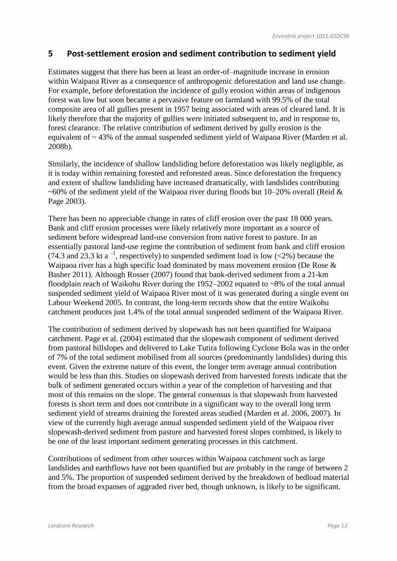
(Dymond et al. 2006). These figures show that a forest cover affords considerable protection
against the initiation of landslides and is consistent with process-based research showing little
difference in the magnitude of interception loss, as a percentage of rainfall, across different,
closed-canopy vegetation communities (Rowe et al. 1999). Soils under a forest cover will
therefore be less prone to rainfall-induced landslides than similar soils under pasture (Fig. 11)
or soils with an open or partial vegetation cover such as young stands of pines < 5-years old
and scattered, regenerating scrub that sustain a similar level of landslide damage (Marden &
Rowan 1993).
Figure 11 Contrasting incidence of shallow landsliding on pasture and a closed-canopy stand of native forest
following Cyclone Bola in March 1988.
Within forested areas, and particularly during extreme rainfall events, factors additional to the
soil-water regime are also likely to influence landslide initiation. These include stand density,
root-system dimensions, and the magnitude of root-soil reinforcement. Comparisons of
excavated root systems of kānuka and P. radiata revealed that, although the roots of
individual kānuka were smaller than those of P. radiata at all stages of growth, the difference
in total root mass was more than compensated for by the higher stand densities of the kānuka.
Thus, the annual rate of root production of stands of regenerating kānuka exceeds that of P.
radiata for the first 9 years of growth (Watson et al. 1995). As a consequence, the calculation
of slope safety factors (a measure of a slope’s resistance to failure) showed that slopes with a
dense stand of regenerating kānuka were less likely to fail than similar slopes in P. radiata, at
least for the first 9 years after establishment. Thereafter, older aged stands of both species
afforded a high and comparable level of slope resistance against landslide initiation
(Ekanayake et al. 1997).
A study of the relationship between soil erosion and farm conservation plantings
(predominantly deciduous poplar and willow) concluded that the effectiveness of these
plantings was contingent on correct planting and maintenance. Appropriately planted and
maintained trees reduced erosion by 75% compared with similar unplanted slopes, whereas if

Envirolink project 1015-GSDC96
Landcare Research Page 17
improperly installed and not maintained their effectiveness declined to 10%. The same study
concluded that properly installed farm conservation trees (planting density unspecified), close
afforestation with pines, and reversion to native scrub all reduced erosion (erosion type not
specified) by about the same amount (Hicks 1991).
7.2 Earthflows
There can be little doubt that the removal of the original indigenous forest cover increased the
risk of earthflow initiation and that the absence of a forest canopy and lack of a dense
network of intertwining roots in the subsoil is directly related to today’s accelerated rates of
earthflow movement on pastoral hill country (Marden et al. 1992).
Surface-movement studies of a grassed earthflow complex (Fig. 12) showed that surface-
displacement rates were fastest during wet periods and were moderately correlated with
monthly rainfall (Zhang et al. 1993). In an earlier study it was shown that the difference in
movement rates between reforested and grassed earthflows represents an order of magnitude
reduction in erosion rate by earthflows after reforestation, with interception loss by the forest
canopy being the principal contributing factor (Pearce et al. 1987). Depending on planting
density and growth rate, canopy closure in this area occurs within 8–10 years of planting
pines. Thereafter, the soil water content of forested earthflows is dryer for longer periods than
grassed earthflows and as a consequence surface displacement slows appreciably (Pearce et
al. 1987). Surface displacement of the earthflow depicted in Figure 4 (this report) slowed
within 4 years of planting and by 2000 the earthflow had stabilised.
Figure 12 Actively moving earthflow under pasture (left) stabilised following establishment of a closed canopy
of exotic pines.
In addition, and at about the time of canopy closure, the root systems of 8–10-year-old pines
are known to develop both strong lateral structural roots, which may extend up to 5 m from
the root bole, and vertical sinker roots up to 2.1 m deep (Watson et al. 1999). Given that most
earthflow displacement occurs along a basal shear plane typically 5–7 m below the ground
surface and at a depth exceeding that of the maximum root penetration of most forest tree
species, it has been suggested that where trees are planted close enough, the roots of
individual trees interlock to form a large raft. The interlocking roots constitute a reinforced,
semi-rigid layer that floats on the more mobile material beneath (Zhang et al. 1993).

Envirolink project 1015-GSDC96
Page 18 Landcare Research
Through its superior interception function, a closed-canopy of evergreen forest affords the
best option for stabilising mobile earthflows. However, earthflows can be stabilised by space-
planted trees and afforestation, along with the use of subsurface drains and diversion banks.
Tree spacings recommended vary depending on attributes such as the extent of the earthflow,
its movement, and stage of development, and depth to the failure plane. On intermittently
moving or creeping earthflows, tree spacing of < 12 m may enable adequate erosion control
and satisfactory pasture production, whereas for more active, continuously moving
earthflows, spacings < 5 m are recommended to encourage development of a denser root
network. Deep earthflows (e.g., several metres deep) are much more difficult to control with
vegetation and dewatering with fast-growing evergreen species and subsurface drains are
recommended.
7.3 Gullies
Gully erosion is prevalent in many East Coast catchments with most gullies forming after the
indigenous forest was cleared and the land converted to pasture in the first quarter of the 20th
century. Within three or four decades after deforestation the headwater reaches of the
Waipaoa catchment had become severely degraded with gullies occupying ~2% of a 14-km2
study area. By the early 1960s the area affected by gullies increased to a maximum of ~4%,
but 24 years after reforestation with exotic species this had decreased by ~64%, to 1.5% of
the study area (Marden et al. 2005).
Canopy closure models (Marden et al. 2005, 2011) developed to measure the effectiveness of
exotic forest in stabilising gullies showed that the time required to ‘shut down’ gullies was
strongly associated with gully size and the duration (years) since planting and, for gullies of
equivalent size, the duration since planting is similar in both geological terrains. Also, linear
gullies are likely to stabilise earlier than their amphitheatre-shaped counterparts. Physical
evidence that reforestation has been effective in stabilising gullies include channel narrowing
and incision as an initial response to the decrease in sediment yield. A similar response to
reforestation has been widely documented, notably in Europe where major reforestation
occurred a century ago (Garcia-Ruiz et al. 1997; Liébault & Piégay 2001; Surian & Rinaldi
2003, Piégay et al. 2004). Additional indicators are the survival of forest plantings within a
once-active and open gully, channel incision into depositional fans emanating from them, and
the subsequent stabilisation of these fans (Fig. 13).
Envirolink project 1015-GSDC96
Landcare Research Page 19
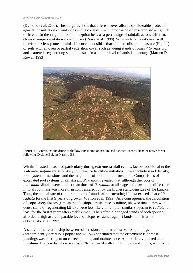
Figure 13 A medium-sized gully (7.6 ha) before reforestation (1961) and post-reforestation (1972, 2004).
Within 10 years (1972) the planting of pines had effectively reduced sediment input into the channel and the
channel responded by incising below the level of the fan at the mouth of the gully. The latest photograph shows
that in spite of a major cyclonic event in 1988 (Cyclone Bola) this and similarly reforested gullies of equivalent
size have remained stable.
At catchment scale, the magnitude in the reduction in gully-derived sediment yield reflects
the timing and area of land reforested. In the Waipaoa catchment, the early establishment
(1960s to 1980s) of exotic forest in the most gully-prone part of this catchment resulted in a
33% decrease in gully-derived sediment yield. The benefits of later plantings (1990s) have
yet to be realised.
7.4 River banks and cliffs
Although the planting of streambanks, largely with poplars and willows, as a means of
slowing streambank erosion is a widespread practice, there is little documentation of its
effectiveness. Similarly, the benefits of the establishment of native riparian strips or
encouragement of natural reversion along waterways as a means of trapping sediment derived
from mass movement processes is largely unproven. There are documented cases where mass
movement failures (landslides) originating upslope of existing riparian buffers have passed
through the buffer with little or no sediment trapped by the buffer. However, their value in
filtering pathogens and chemicals from agricultural land has been documented (Collins et al.
2007).
7.5 Aggraded river beds
Attempts to revegetate actively aggrading reaches of river beds as a means of slowing the rate
of sediment mobility within a river channel have met with mixed success. While some
accounts indicate that the revegetation of river bars slows sediment mobility, thereby
retaining the sediment in headwater catchments, others actively remove vegetation to increase
sediment transport rates through the river channels so that aggradation does not occur.

Envirolink project 1015-GSDC96
Page 20 Landcare Research
7.6 Slopewash
Maintenance of a complete, healthy ground cover is essential for effective prevention or
control (Hicks 1991; Hicks & Anthony 2001). This can be achieved through pasture
improvement using cultivars of grasses and legumes that are persistent and adapted to
drought, wet, cold, and variable intensities of grazing pressure. Associated with this are
management options such as subdivision of large blocks (e.g., sunny vs shady aspects) and
improved stock grazing practices (e.g., destocking paddocks at particular times of the year,
more rotational grazing), and maintenance of soil fertility through strategic topdressing and
animal transfer. Cover of unimproved pasture swards can also be maintained using some of
these management options, but pasture growth responses are not generally as large as when
applied to swards comprising improved pasture cultivars.
8 Modelled reductions in sediment yield following reforestation
In degrading catchments dominated by hill country (e.g. Waipaoa catchment), shallow
landslides are often perceived to be the most important source of sediment. While shallow
landslides supply as much as 60% of the suspended sediment transported during high flow
events they overall generate only 10 to 20% of the Waipaoa River’s annual suspended yield
(Page et al. 2000; Reid & Page 2003). A modelled reforestation strategy (Fig. 14) aimed at
prioritising land for reforestation according to landslide susceptibility could have a significant
impact on fine sediment yields. With prioritisation, a 40% reduction in landslide-derived
sediment could be achieved through reforestation of 8% of the Waipaoa River basin, whereas
25% of the land would need to be reforested to achieve the same effect through random
selection (Reid & Page 2003).

Envirolink project 1015-GSDC96
Landcare Research Page 21
Figure 14 Percentage change in landslide-derived sediment for different levels of reforestation for two
reforestation strategies.
In contrast, gullies are the dominant sediment source in each of the major river systems in
this region. For the period since reforestation began gullies have generated the equivalent of
43% of the average annual suspended sediment yield of the Waipaoa catchment (Marden et
al. 2008b).
Based on the gully degradation model presented in Marden et al. (2008b) and gully
stabilisation models in Marden et al. (2005, 2011), further models have been developed
specifically to forecast potential reductions in sediment yields from remaining untreated
gullies, including those already considered too large to stabilise through reforestation (Herzig
et al. 2011). Several practical reforestation scenarios were considered (see Table 2 in Herzig
et al. 2011). The results show that reforestation would be most effective if all remaining
gullies in the Waipaoa catchments were to be planted before 2020, and providing no new
gullies developed during this period, the annual sediment yield could be halved by 2030 and
remain constant thereafter (Fig. 15). Within Waipaoa catchment if the remaining 413
untreated gullies were to be treated and if no new gullies formed before 2050 it is expected
that sediment yield would decline to ~2 Mt/year by the end of the modelling period (Fig. 15).
Conversely, if new gullies were to form and remained untreated during this period, the annual
sediment yield as at 2050 would be approximately twice that if no new gullies were initiated
(Herzig et al. 2011).

Envirolink project 1015-GSDC96
Page 22 Landcare Research
Figure 15. Modelled reductions in gully-derived sediment yield (Million tons per year) if all remaining gullies
within the respective catchments were to be reforested by year 2020. Solid line includes sediment yield from
new gullies initiated but not treated during the modelling period. Dashed line assumes that no new gullies were
initiated during the modelling period.
8.1 Sediment from harvested areas of exotic forest
It is well documented that forests in general terms result in a reduction of sediment generated
from eroding hill slopes and improve overall stream health (Parkyn et al.2006). However,
Fahey and Marden (2000) and Fahey et al. (2003) showed that during the harvesting phase
there is a sharp increase in suspended sediment yield but this declined over a 2-year period
and within 5 years had returned to pre-harvest levels. In other studies of slopewash-derived
sediment on harvested slopes the largest proportion of sediment generated occurred within a
few months of clearfelling and within less than 2 years had declined to almost zero. The same
study showed that a single landslide contributed the equivalent of ~6000 times more sediment
than was delivered to the stream by slopewash from a 38-ha area of clearfelled forest
(Marden et al. 2007). Within the Waipaoa catchment the progressive harvesting of exotic
forest began in 1990 and will continue henceforth. The size of the area harvested at any one
time is small relative to the size of the catchment as a whole and any resultant increase in the
amount of sediment generated during the harvest phase will not be detectable at the
catchment scale. Nonetheless, there have been increasing instances when large volumes of
sediment have been generated from forests. This usually occurs when a storm event coincides
with the location of an area of recently harvested forest and/or areas replanted in pines
younger than about 8-years old, that is, before replanted areas have attained canopy closure
(Marden & Rowan 1995; Phillips & Marden 1996; Basher 2010). During these storms
Envirolink project 1015-GSDC96
Landcare Research Page 23
sediment is generated from natural slope failures (landslides) and failures associated with
forestry infrastructure such as landings and roads. Sediment, when combined with logs,
logging waste (slash) and flood waters, produce debris flows that often result in severe
scouring of ephemeral stream channels. The runoff and entrained debris can bring about
serious on- and off-site damage to roads, cause washouts, block culverts and bridges, and
trigger the flooding of low lying land. During such events debris-laden sediment often
reaches the coast, resulting in off-shore sedimentation and the accumulation of woody debris
on beaches.
9 Off-site benefits of sediment reduction
9.1 Protection of infrastructure
In the Waipaoa catchment the continued sediment generation from large gully complexes that
have remained ‘active’ within reforested areas, together with sediment derived from untreated
gullies and shallow landslides on farmland, has led to an increase in the rate at which
alluvium has accumulated on the Poverty Bay flats. Overbank deposition periodically
continues to increase the elevation of the active floodplain and reduce the standard of flood
protection. This off-site impact suggests that remediation efforts should focus on the benefits
of on-site management strategies and conservation measures, previously shown to be
effective in reducing the supply of sediment, by targeting remaining untreated gullies
(Marden et al. 2011) and land classes most susceptible to shallow landsliding (Reid and Page
2003) for reforestation. The contribution to the overall budget of the Waipaoa River derived
from earthflows is unknown. As not all earthflows are necessarily active at any one time, and
given the low periodicity and slow pace of activity, the amount of sediment earthflows
deliver to the Waipaoa River may be minor. Banks and cliffs probably generate < 2% of the
sediment budget (DeRose & Basher 2010) and slopewash < 1%.
Prevention of sediment entering the drainage network, particularly from gullies and shallow
landslides, probably represents the most sustainable management option. Attempting to retain
sediment in aggraded reaches of channels is likely to be high risk and the least effective
management option.
In the longer term, as a consequence of an expected reduction in sediment generation from
hill slopes following reforestation, bed load aggradation rates will decline (Peacock & Turner
2003; Peacock & Marden 2004). This will in turn result in additional benefits, namely: 1) a
reduction in the cost of bridge replacement and road repair; 2) obviation of the need for
expensive channel excavation, realignment and /or stopbank construction; and 3) likely
reduction in the risk and clean-up costs associated with the flooding of low-lying, high-value
farmland.
9.2 Stream health
Parkyn et al. (2006), in comparing the water quality and stream ecological ‘health’ of streams
in pasture, pine plantation, and native forest in catchments that were characterised by
differing forms of erosion, concluded that streams in mature pine plantations had generally
better water quality (lower faecal contamination and nutrient concentrations) than in pasture,

Envirolink project 1015-GSDC96
Page 24 Landcare Research
and tended to approach the condition of reference streams in native forest. Visual clarity and
turbidity and particulate forms of nutrients, however, remained degraded in pine plantations
where deeply incised gullies continued to yield large amounts of fine sediment and were
therefore more strongly associated with geological differences than land use. Nonetheless,
given that invertebrate community metrics of stream health were more degraded in pasture
streams than in streams draining mature pine and native forest, the conclusion drawn was that
a pine plantation established on degraded pastoral hill country in soft rock terrain appeared,
in time, to improve water quality and stream health toward conditions found in streams
draining native forest.
This study is of importance to the Waipaoa Catchment as one of the sites studied included an
area of native bush, an exotic forest and a pasture sub-catchment located in the Te Arai River
catchment. The waterworks bush reserve is the only significant area of in-tact native forest
remaining in Waipaoa catchment and from which a substantial proportion of Gisborne City’s
water supply is drawn. This then potentially becomes the reference stream (Fig. 16) with
which to compare water quality and stream ecological ‘health’ of other streams elsewhere
throughout Waipaoa catchment.

Envirolink project 1015-GSDC96
Landcare Research Page 25
Figure 16 Section of Te Arai River upstream of Gisborne water uptake. Note the predominance of cobble- and
boulder-sized material and lack of ‘fines’ comprising the bedload. Presumably most of the riverbeds within the
Waipaoa catchment looked like this in pre-settlement times when the catchment was fully forested.
The results from the area of exotic forest indicate how quickly stream health can return to an
acceptable standard and those from the pasture catchment could be considered as the current
norm for all remaining areas of pastoral hill country and requiring improvement.
9.3 Best Management Options
Best management practices are practical mitigation measures that can prevent or reduce the
movement of sediment, microbes, nutrients and other pollutants from the land to streams or to
groundwater. These practices are generally site specific and are developed to achieve a
balance between water quality protection and economically viable agricultural activities
(Ballantine & Davies-Colley 2009).
9.4 Fencing waterways and establishing riparian plantings
Grazing animals in hill country areas migrate to waterways and can severely damage
streambanks adding both sediment and faecal matter to streams. While fencing and the
establishment of vegetation may prevent livestock access to streams and greatly reduce faecal
pollution, sediment runoff and damage to stream banks, it is only practical where river
terraces flank a stream and occur above the maximum flood level (Fig. 17). Fencing and
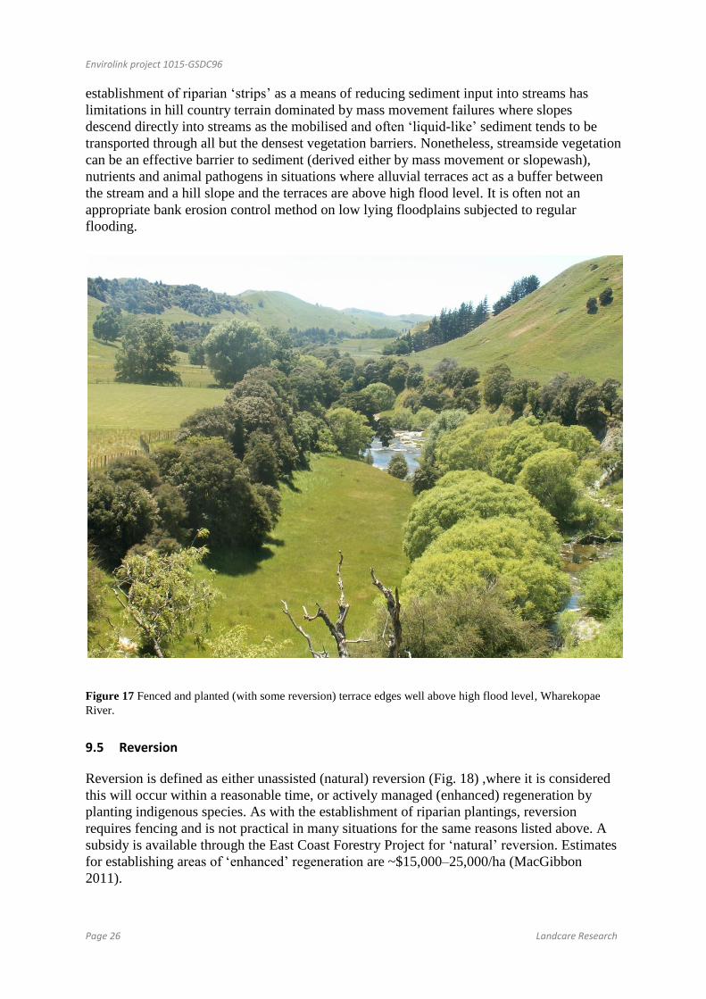
Envirolink project 1015-GSDC96
Page 26 Landcare Research
establishment of riparian ‘strips’ as a means of reducing sediment input into streams has
limitations in hill country terrain dominated by mass movement failures where slopes
descend directly into streams as the mobilised and often ‘liquid-like’ sediment tends to be
transported through all but the densest vegetation barriers. Nonetheless, streamside vegetation
can be an effective barrier to sediment (derived either by mass movement or slopewash),
nutrients and animal pathogens in situations where alluvial terraces act as a buffer between
the stream and a hill slope and the terraces are above high flood level. It is often not an
appropriate bank erosion control method on low lying floodplains subjected to regular
flooding.
Figure 17 Fenced and planted (with some reversion) terrace edges well above high flood level, Wharekopae
River.
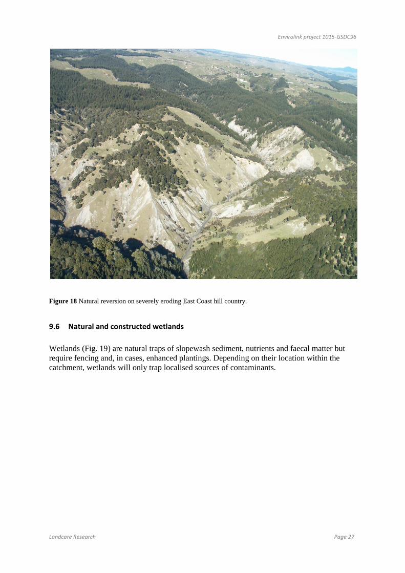
9.5 Reversion
Reversion is defined as either unassisted (natural) reversion (Fig. 18) ,where it is considered
this will occur within a reasonable time, or actively managed (enhanced) regeneration by
planting indigenous species. As with the establishment of riparian plantings, reversion
requires fencing and is not practical in many situations for the same reasons listed above. A
subsidy is available through the East Coast Forestry Project for ‘natural’ reversion. Estimates
for establishing areas of ‘enhanced’ regeneration are ~$15,000–25,000/ha (MacGibbon
2011).
Envirolink project 1015-GSDC96
Landcare Research Page 27
Figure 18 Natural reversion on severely eroding East Coast hill country.
9.6 Natural and constructed wetlands
Wetlands (Fig. 19) are natural traps of slopewash sediment, nutrients and faecal matter but
require fencing and, in cases, enhanced plantings. Depending on their location within the
catchment, wetlands will only trap localised sources of contaminants.

Envirolink project 1015-GSDC96
Page 28 Landcare Research
Figure 19 Reinstating a previously drained wetland, Nicks Head Station.
9.7 Debris dams/stock ponds
The construction of debris dams in combination with pole plantings in small streams and
gullies has been used for years to prevent small streams from incising and thereby reduce
their potential to generate sediment. While debris dams are useful for trapping mostly
sediment from localised sources, they are costly and labour intensive, and the technique
proved unsuccessful in retaining sediment derived from large and active gullies. Without
subsidies very few debris dams are currently being built.
9.8 Culverts/bridging of stream crossings
The construction of bridges and culverts aimed at keeping stock out of waterways has
improved water quality in the Sherry Catchment (Ballantine & Colley 2011).
9.9 Reforestation/soil conservation planting
Hill slopes with mature cover of native or exotic forestry have the lowest incidence of erosion
and this appears largely independent of species (Phillips et al. 1991; Brown 1991; Hicks
1991, 1995; Marden & Rowan 1993; Hicks & Crippen 2004). The major considerations for
erosion management in tree plantations focus on establishment and harvesting activities,
where vegetation removal and mechanical earthworks temporarily increase soil movement
and the risk of significant soil loss. The forestry industry and government agencies have thus
developed extensive guidelines (NWASCO 1978; Vaughan 1984; Spiers 1987) and a code of
practice (Vaughan et al. 1993; New Zealand Forest Owners Association 2007) to guide

Envirolink project 1015-GSDC96
Landcare Research Page 29
operational planning and maintain soil and water values through mitigation of erosion and
sedimentation. These focus heavily on the practices that have been shown to contribute most
to sediment generation, particularly management of roads, landings, and stream crossings.
Shallow landslides:
Areas prone to shallow landslides can be identified from the remains of previous slip scars
and from knowledge of the soil type, slope, existing vegetation cover, and total rainfall and
its distribution. Landsliding can be reduced or prevented by:
ensuring a dense, healthy pasture sward coupled with establishment of wide-spaced
trees, e.g. Populus spp., to provide deeper root-reinforcement of the substrate, and
transpiration to reduce soil pore water pressure
changing land use to regenerating scrub – indigenous forest, or
establishing exotic forest for commercial timber production
(see Hathaway 1986; Lambrechtsen 1986; Pollock 1986; Brown 1991; Hicks 1995; Hicks &
Anthony 2001; Quinn et al. 2007).
Revegetation of slip scars occurs naturally through seed dispersal from vegetation on
neighbouring uneroded ground and stock defecation, and can take 20+ years for full
coverage. The process can be hastened by oversowing with appropriate grasses, legumes, and
herbs and seed mixtures are often tailored to site conditions to accommodate variation in such
attributes as aspect (sunny vs shady), soil pH, and soil type (Lambrechtsen 1986; Lambert
etal. 1993; Quilter et al. 1993). Opinion varies on the best time to oversow slips, ranging from
as soon as possible after landsliding, while the sites are still moist, to autumn or spring in line
with the timing of normal oversowing practice. Total sowing rates of 60–100 kg/ha or even
higher have been used, but for general practice, they are uneconomic. Litherland et al.
(2005a, b) describe experiences with regrassing slips and silt-covered areas following the
2004 Manawatu storm and suggest recommendations for best practice. Vegetation (both
pasture and primary succession to natives) and soil recovery rates are described in Lambert
et al. (1993), DeRose et al. (1995), Smale et al. (1997), and Sparling et al. (2003). These
studies indicate landslide erosion causes a permanent reduction in mean herbage production
and soil depth on hillslopes.
Trees for slope stabilisation should be planted at 5 × 5 m to 15 × 15 m (Hathaway 1986a)
depending on the severity of landsliding, and it is recommended that planting be extended
beyond the slipped land onto relatively stable ground. Lateral roots of broadleaved trees
interlock for distances of up to 12 m from the trunk, and form very dense networks within 5–
6 m of the trunk (Hicks 1995). Trees can be planted on slipped sites but it is recommended
that they be planted on sites with potential to slip (Hicks and Anthony 2001), rather than for
remediation.
Gully erosion
Most control of this erosion type aims to reduce further deepening and undercutting in the
gully and its consequent effects on surrounding slope stability and reducing sediment
Envirolink project 1015-GSDC96
Page 30 Landcare Research
discharge (Hathaway 1986b). The severity of the gully often dictates the type of treatment.
For shallow (<2 m deep) gullies, spaced planting of Populus spp. or Salix spp., in
combination with engineering structures (e.g. debris dams) while the trees establish, is
recommended. For moderate (2–5 m deep) gullies the outcome of this type of treatment is
less certain.
Tree planting patterns and spacings vary depending on the severity of erosion; with the most
successful system being ‘pair planting’ up the watercourse at spacings of 2–10 m between
pairs. Each pair comprises a tree on opposite sides of the watercourse, frequently between 1
and 2 m apart, or alternate planting in a ‘zigzag’ fashion along opposite sides of the
watercourse (Hathaway 1986b; Hicks 1995; Hicks & Anthony 2001). The main treatment
options for controlling gully erosion were presented in a hierarchical structure by Thompson
and Luckman (1993), and although somewhat arbitrary, the classification is useful in the
context of land management. They summarised the techniques commonly used to control
gullying in soft rock terrain as debris retention dams, channel (or pair) planting, gully wall
planting, and afforestation.
Severely eroded gullies should be retired from grazing and closed-planted with trees
(Hathaway 1986b; Hicks 1995; Hicks & Anthony 2001). Considerable experience has been
gained with plantings of Pinus radiata but other species may also be used (e.g. Populus spp.).
The land stabilisation role of the trees is paramount and therefore they should generally not
be harvested for timber, although currently many gullies that have previously been afforested
are being harvested (e.g. at Mangatu Forest). Succession to indigenous scrub and forest
should be a long-term objective. There has been some success with retirement, planting Salix
spp., and then selectively removing the trees to encourage establishment and growth of
indigenous species. Depending on the severity and distribution of gully erosion in a
catchment, treatment may range from individual gullies and their perimeters being planted, to
afforestation of most or all of the catchment.
Earthflow erosion
There is a range of vegetation techniques to control earthflows including options such as
space-planted trees and afforestation; non-biological options include subsurface drains and
diversion banks (Thompson & Luckman 1993). Tree spacings recommended vary depending
on attributes such as the extent of the earthflow, its movement and stage of development, and
depth to the failure plane. On intermittently moving or creeping earthflows, tree spacing of
>8 m may enable adequate erosion control and satisfactory pasture production. When using
broadleaved tree species for control of mass movement such as earthflows, Hicks (1995)
recommended that trees should be 12 m apart or closer to ensure some interlocking of roots
from adjacent trees. For more active, continuously moving earthflows, spacings < 5 m (400+
stems per hectare) are recommended to encourage development of a denser root network.
Recommendations on appropriate control techniques vary with site geomorphology (Hicks &
Anthony 2001). On crushed argillite, options are erosion control forestry, dewatering, and
construction of debris dams, whereas on other sedimentary rocks, pole planting and
dewatering are recommended. Successful control of shallow earthflows (< 3 m deep) has
been achieved using various plantings of Populus spp. and Salix spp. Deep earthflows (e.g.
several metres deep) are much more difficult to control with vegetation, and dewatering with
fast-growing evergreen species is recommended (Hicks & Anthony 2001). Reforestation at >
Envirolink project 1015-GSDC96
Landcare Research Page 31
1200 stems per hectare affords the quickest and cheapest means of stabilising deep
earthflows.
Slump erosion
Mitigation options are similar to those used to manage earthflow erosion. Spaced planting of
trees in pasture is an effective preventative technique for potentially active sites or those with
limited movement, and may offer some control on more active terrain. Depth of the failure
plane is an important influence on how effective spaced-tree planting will be, and at depths
greater than 5 m, additional control methods such as drainage will probably be necessary.
Engineering methods have been used (Hicks 1995) to stabilise large, deep-seated slumps in
bedrock where erosion threatens valuable infrastructure (e.g. roads, buildings) but their high
cost precludes general applicability.
Severe slumping may require retirement from grazing and afforestation (close spacing) with
species such as Populus, Salix, and Pinus radiata and other conifers (Hicks & Anthony
2001). The priority should be to retain the forest long-term. Harvesting for timber may be
considered but care should be taken in deciding which trees are harvested. Replanting is
recommended as soon as possible after harvesting to enable a new root system to develop
before the previous system decays significantly. Encouraging the development of indigenous
forest may offer better long-term stability.
9.10 Floodplains and estuaries as sediment traps
Floodplains and estuaries are considered to intercept only a small percentage of the total
sediment delivered to the coast (Hicks et al. 2011). For example, Gomez et al. (1999) found
that the Waipaoa floodplain intercepted only 5% of the 15Mt/year of its suspended sediment
load over an 11-year period (1979–1990). More particularly, floodplain sequestration
amounted to only 16% of the suspended load carried during events that exceeded the bankfull
discharge, which included the 70-year return period flood of March 1988 associated with
Cyclone Bola (Peacock & Philpott 2009). Supporting this, Hicks et al. (2000, 2002) used an
extensive set of suspended sediment gaugings to show that 86% of the Waipaoa River’s
suspended load was carried at sub-bankful flows. The most effective strategy for sediment
entrapment is to intercept it near source rather than sequestering it on the floodplain.
10 Prioritisation of areas for best management options (BMPs)
Priority areas will need to be selected at varying scales (sub-catchment, single reach of a
major river, swampy part of a small stream, existing wetland or create new ones, etc.) and
matched with BMPs where remediation would be expected to produce a beneficial outcome,
i.e. a reduction in sediment yield and/or improved stream health.
Realistically, sediment reduction is more likely in parts of catchments where sediment is
generally produced by surficial erosion processes such as slopewash and periodic shallow
landsliding but less likely in catchments where erosion is dominated by mass movement
processes and /or gullying. It would also be possible to make a difference at a localised scale
( on-farm) but unrealistic to expect a measureable difference in suspended sediment yield in
Envirolink project 1015-GSDC96
Page 32 Landcare Research
the bigger rivers, especially those with large volumes of sediment storage in their channels
(e.g. Mangatu, headwater reach of Waipaoa River) or those rivers with extensive areas of
floodplain where stream banks comprise unconsolidated sands and silt (e.g. lower reaches of
Te Arai, Wharekopae, Totangi, Waikohu, Waingaromia and Waihora).
Positive outcomes are more likely to be achieved in sub-catchments with a ‘low’ base
sediment yield (e.g. Wharekopae, Waikohu and Waihuka) with extensive channel incised
between banks of bedrock rather than alluvium (unconsolidated silt and sand). Typically, the
stream beds of these reaches comprise cobble- and boulder-sized material with little stored
sand and silt, indicating that hill slope erosion upstream of these reaches produces little fine
material, most of which is able to be mobilised down the channel rather that stored as
bedload.
11 Impact of climate change on hill country erosion
The main features of the New Zealand climate projections for the 2030s and 2080s include:
Mean temperature is projected to increase (mid-scenario) 0.6–0.7°C by 2030s and 1.6–
2.0°C by 2080s, with the strongest warming in winter, and a tendency for slightly more
warming in the east and north.
Daily temperature extremes will increase with fewer cold temperatures and frosts and
more high temperature episodes projected.
Mean rainfall impacts will vary around the country, with a tendency for annual rainfall
to decrease in the north and east and increase in the south and west, associated with a
stronger west-east rainfall gradient. Changes of the order of −5 to +5% by the 2030s
and −10 to +15% by the 2080s are expected.
Heavier and/or more frequent extreme rainfalls are expected, especially where mean
rainfall increases are predicted, since a warmer atmosphere can hold more moisture
(about 8% more for every 1ºC increase in temperature). There may be up to a four-fold
reduction in storm return period by the 2080s, although there is little quantitative
information available1. The frequency of extra tropical cyclones (which bring large
storm events to the north and east of New Zealand) is predicted to decrease but their
intensity is expected to increase.
An increase in both mean annual westerly windflow and severe winds that cause wind
erosion.
The impact of climate change on soils and landscape processes has been reviewed by Basher
(1990) using earlier estimates of likely climate change scenarios.2 The direct effect of climate
change on erosion is likely to be reflected in changes to the rates of erosion processes rather
than the types of erosion occurring. The greatest effects are likely to occur through changes to
1 Gray et al. (2005) provide guidance on how to assess likely changes in extreme rainfall
2 The 2007 IPCC estimates of climate change alter the magnitude of likely temperature rise but provide little
more detail on impacts on rainfall amounts, intensities or frequency of large storms.

Envirolink project 1015-GSDC96
Landcare Research Page 33
precipitation processes and regimes, which will affect rates of erosion processes and recovery
of vegetation following erosion. The pattern of erosion would be similar to the present, but
the rates of individual erosion processes would be determined by changes in the frequency
and magnitude of rain and wind storms. Annual rainfall is the dominant control on rates of
erosion, as measured by suspended sediment yields (Griffiths 1981, 1982; Hicks et al. 1996),
and if rainfall increases as predicted for many parts of the country, then erosion rates can be
expected to increase substantially. Since most erosion occurs in large storm events, and these
are predicted to increase even in areas where annual rainfall decreases, further information on
likely changes in their patterns, frequency, and intensity is needed to assess quantitatively the
likely impact of climate change on hill country erosion. Climate scenarios suggest that for
many areas there would be an increase in high-intensity storms (i.e. more rain on fewer days)
and an increase in intensity of cyclonic storms of tropical origin, especially in the North
Island. Tropical cyclonic storms tend to cause mass movement erosion and flooding over
wide areas as experienced during Cyclones Alison (Bell 1976) and Bola (Trotter 1988).
Likely changes in their frequency and magnitude are currently poorly known.
Temperature changes will modify water balance. With the projected increases in erosion
rates, water storage and retention capability of hillslopes will be severely reduced because the
storage capacity provided by the porous regolith will be depleted with removal leading to
increased droughtiness especially in eastern regions. As a consequence, more land will be
exposed to sheet and wind erosion with drought effecting vegetation cover and re-
establishment.
The newly exposed slip surfaces will also rapidly shed runoff water. Downstream channels
will be affected by the increased frequency and magnitude of storm flows and consequently
may become destabilised. Where there is a high degree of coupling between erosion
processes and the drainage system, sediment supply will be enhanced. Low-gradient
watercourses will consequently aggrade, reducing channel capacity and promoting overbank
flooding.
The impacts of climate change on soils and landscape processes on the hill country in the
Gisborne region can be summarised as follows:
This area is likely to become drier overall. However, there is likely to be a significant
increase in landslide erosion on the steep Tertiary soft rock hill country, especially on
deforested slopes, with predicted higher-intensity rainfalls and intensity of extra-tropical
cyclones (i.e. more ‘Bola’-like storms with major effects on the hill country) (after Basher
1990).
11.1 Implications from process studies
Several key findings have come out of the extensive literature on erosion processes:
Geology (rock type, induration, regolith composition, drainage, and permeability),
uplift rates, and climate (rainfall amounts, intensities) largely determine the landscape’s
inherent susceptibility to erosion. Susceptibility to erosion is readily identifiable at a
regional scale and increasingly at hillslope and farm scale.
Shallow landslides affect the greatest proportion of hill country terrain; earthflow,
slumps, and gully erosion are far less extensive and frequent. The relative impact of
Envirolink project 1015-GSDC96
Page 34 Landcare Research
sheetwash erosion and its contribution to the sediment budget in pastoral hillcountry
areas (farm scale/catchments/erosion terrains/regions/nationally) is poorly known.
Sheetwash is the least important of the sediment-generating processes on forest cutover,
with shallow landsliding, roads, and landings generating the most sediment. Shallow
landslides and gully erosion result in the greatest long-term, on-site (soil loss) and off-
site (sedimentation and flooding) environmental degradation.
In all terrains, but particularly in terrains identified as highly erodible, gully erosion
needs to be identified and treated early. Untreated gullies increase in size and activity
over time, lessening the chance of treatment being successful.
Large storms, or long wet periods, drive mass movement (landslide, earthflow, slump)
on hillslopes. These are high-magnitude events that occur at low frequency. In
catchments where these features dominate the landscape, sediment production from
mass movements dominates catchment sediment budgets during, and for a short time
after, storm events.
For fluvial erosion (gullying, bank and channel erosion) the smaller more frequent
storms are more important (i.e. low-magnitude, high-frequency events) because they
are directly connected to the stream network. A substantial proportion of the sediment
generated between large climatic events can be generated by these processes, and in at
least some landscapes they can dominate overall sediment generation. Recovery of
river networks from the impacts of gully-derived sedimentation is slower (decades to
millennia) than for rivers periodically impacted by other sediment-producing processes
(annual to decade).
Earthquakes are a significant driver for deep-seated mass movements but are far less
frequent.
Closed-canopy woody vegetation (evergreen species) reduces rates of hillslope erosion
by an order of magnitude on the most susceptible terrain. On other less susceptible
terrains hillslope erosion is reduced but the degree of reduction is not as well
quantified, especially for space-planted poles.
The impacts of pre- or post-European deforestation have persisted for more than a
century especially in those landscapes with thick regoliths and/or soft rocks.
Harvesting of forests in highly erodible terrain increases erosion rates in the short term,
but over the length of a forest rotation (c. 27–30 years) pasture produces four times
more sediment than forestry.
Across all terrains, vegetative erosion control through reforestation, reversion, and pole
planting has proven successful for controlling much of the erosion. However, the use of
pole planting for the treatment of large and active mass movement features (earthflow
and slump) and gully erosion, in the most highly erodible terrains, has had only limited
success. Space-planted poles can provide protection against the initiation of shallow
landslides if planted in sufficient numbers and in the appropriate position on slopes.
Failure to recognise this has resulted in a poor outcome for many past soil conservation
efforts.
Storm-initiated landslides deplete the soil resource on hill country. Soil loss as a
consequence of recurrent storm events is cumulative. Soil recovery on landslide scars is
slow. Productivity after 20 years is 80% of that for stable sites unaffected by
landsliding.

Envirolink project 1015-GSDC96
Landcare Research Page 35
Climate change is likely to exacerbate erosion problems in the worst affected areas
since it is predicted to cause heavier and/or more frequent extreme rainfalls. This will
result in a higher incidence of landsliding, and gullying in some areas where rainfall
increases, and further depletion of the soil resource. Continued soil loss combined with
slow soil recovery will ultimately impact the economic viability of hill country farms,
particularly small farms in the more highly erodible terrains (from Basher et al. 2008).
12 Conclusions
The relative contributions of sediment derived from different sources have changed over time
and in response to different drivers including tectonics, climate and more recently,
deforestation. Prior to human settlement channel incision, shallow and deep-seated landslides
were the major processes that delivered sediment to stream channels. Following
deforestation, gully erosion and shallow landsliding dominate the present-day sediment
budget of the Waipaoa River.
The present day sedimentation problem in the Waipaoa catchment is of historical origin and
can be attributed directly to the dramatic increase in hill slope erosion following clearance of
the indigenous forest from erosion-prone terrain during the early European settlement period.
The delivery of sediment to the main channels of the Waipaoa and Mangatu Rivers, primarily
from gullies, exceeded the rate at which these rivers could transport the material; hence it
accumulated in these channels. This legacy of stored sediment, together with ongoing
sediment delivery from existing, untreated gullies as well as that derived from shallow
landslides during periodic storm events, has the greatest, long-term, on-site (loss of soil depth
and productive capacity) and off-site (sedimentation and flooding) environmental impact.
Although other sediment-generating processes, including earthflows, slumps, bank and cliff
erosion and slopewash, can at times be significant sources, they tend to be localised and
‘event driven’, and their contribution, relative to gullies and shallow landslides, is small and
short term.
Geology (rock type, induration, regolith composition, drainage and permeability), uplift rates,
and climate (rainfall amounts and intensities, frequency of large storms) largely determine the
landscape’s inherent susceptibility to erosion, including the response to vegetation change.
Susceptibility to erosion is readily identifiable at a regional scale and increasingly tools and
methods are becoming available that can be used at hillslope and farm scale. Large storms, or
long wet periods, drive mass movement (landslide, earthflow) on hillslopes. These are high-
magnitude events that occur at low frequency. For fluvial erosion (gullying, bank and channel
erosion) the smaller more frequent storms are more important (i.e. low-magnitude, high-
frequency events). Earthquakes are a significant driver for deep-seated mass movements and
are much lower frequency events.
Closed-canopy woody vegetation reduces rates of hillslope erosion by an order of magnitude
on the most susceptible terrain. Past vegetative erosion control efforts through reforestation,
reversion and pole planting has proven successful for controlling much erosion. However, the
use of pole planting for the treatment of large and active mass movement features (earthflow
and slump) and gully erosion, in the most highly erodible terrains, has had only limited
success. Space-planted poles can provide protection against the initiation of shallow
landslides if planted in sufficient numbers and in the appropriate position on slopes. The
encouragement of natural reversion and/or the establishment of riparian vegetation ‘strips’ as

Envirolink project 1015-GSDC96
Page 36 Landcare Research
a means of reducing sediment input into streams has its limitations in hill-country terrain
dominated by mass movement failures as the mobilised and often ‘liquid-like’ sediment tends
to be transported through all but the densest vegetation barriers. Nonetheless, streamside
vegetation can be an effective barrier to sediment (derived either by mass movement or
slopewash), nutrients and animal pathogens in situations where alluvial terraces act as a
buffer between the stream and a hill slope and the terraces are elevated above high flood
level.
Further planting of all remaining gullies, earthflows and of terrain identified as having a high
potential for shallow landsliding is required if further sediment input into the Waipaoa River
is to be minimised. The reforestation of gullies is the most practical and effective means of
stabilising all but the largest of them, and if all remaining untreated gullies were to be
reforested before 2020, and no new gullies were initiated during this period, gully-derived
sediment yield could be halved by 2030 and remain constant thereafter. A modelled
reforestation strategy aimed at prioritising land for reforestation according to landslide
susceptibility could have a significant impact on fine sediment yields. With prioritisation, a
40% reduction in landslide-derived sediment could be achieved through reforestation of 8%
of the Waipaoa River basin, whereas 25% of the land would need to be reforested to achieve
the same effect through random selection Sediment yields from other sources, including
earthflows, stream banks and reworked material in temporary storage as bedload could be
considered as being of lesser concern.
Following reforestation, streams within mature plantation forests have greater stability and
lower water temperature than adjacent pastoral streams, resulting in improved overall stream
ecological health approaching the condition of reference streams in native forest. Reductions
in sediment input and improvements in stream health are possible at a localised scale and
within a relatively short time frame but are unlikely to make a significant difference to the
sediment load or water quality of the Waipaoa River as a whole for many decades, if not
millennia. Without further erosion mitigation intervention and in the event of more severe
storm events, erosion on unprotected hill slopes will increase and further exacerbate the
current sedimentation issues of the Waipaoa catchment.
For sediment management to be effective and sustainable, the fundamental unit of
management should be the river basin. The use of the river basin, as the scale of water and
sediment management, introduces some important issues. First, it is necessary to recognise
the numerous environments within a river basin (including soils/hillslopes, rivers,
floodplains, wetlands, lakes/reservoirs, and the coastal zone) and the interconnectivity
between these environments. The study by Owens et al. (2005) demonstrated the
interconnection between land-use changes on hillslopes, sediment delivery and transport in
rivers, and sediment deposition and flooding in downstream reaches for the Waipaoa River.
This study illustrated the potential for targeted management in headwater reaches to control
downstream problems (i.e. controlling the source of the problem as opposed to downstream
management). Second, there is a need for greater understanding of how the processes that
control sediment generation, delivery, and transport within rivers operate at scales that are
meaningful for management and, based on this, there is also a need to identify which
remediation strategies could provide a reduction in sediment generation from hillslopes and
where to apply them.

Envirolink project 1015-GSDC96
Landcare Research Page 37
The impacts of pre- or post-European deforestation have persisted for more than a century.
Climate change is likely to exacerbate erosion problems and lead to increased sedimentation
since it is predicted to cause heavier and/or more frequent extreme rainfalls.
13 Recommendations and future research needs
In view of the potential worsening of hill slope erosion and its impact on sedimentation
patterns within the Waipaoa River, it is recommended that Gisborne District Council use
NIWA’s River Environmental Classification (REC) by Snelder et al. (2005) as a spatial
framework for mapping and classifying rivers or parts of rivers within the Waipaoa
catchment into REC classes discriminated by variations in physical (land cover, geology,
climate, topography) and biological (water chemistry, biological communities) characteristics
at a range of scales. Classes can be treated as management units, each of which can be linked
to a monitoring strategy and used as a framework for environmental assessment,
management, and reporting.
Use existing data to establish the current ‘base level’ of suspended sediment yield from
monitored sub-catchments and, based on this, use prediction tools/models to prioritise
sub-catchments/parts of sub-catchments according to where greatest gains in sediment
reduction might be possible if mitigation measures were to be implemented.
Develop appropriate erosion mitigation implementation plans targeting existing, active
sediment sources (e.g. gullies) first, then future proof vulnerable areas (e.g. steep hill
slopes, stream banks) through further tree planting (poles, reversion and/or forestry)
A survey of regional councils, industry, central government agencies and science
providers identified a wide variety of research needs to assist improved management of
hill country erosion and resultant sedimentation. Gaps identified by the greatest number
of stakeholders included (from Basher et al. 2008):
ability to measure regional/catchment rates of erosion and determine what is
tolerable, including measuring the contribution from different land uses and
land management practices, being able to distinguish natural and induced
erosion, and the contribution of different processes
integrated research on sediment dynamics (connectivity and lags) within
catchments and downstream effects, including slope–channel linkages
development of erosion prediction tools/models incorporating land
use/management effects and able to distinguish different erosion processes
effectiveness of space-planted trees (including willows, poplars and natives) for
erosion control and their management requirements, and other erosion control
measures, over a range of event magnitudes
cost–benefit analysis of different mitigation techniques including co-benefits of
erosion control on carbon storage, role of erosion in the carbon budget
effective community engagement processes for erosion and catchment
management, and improved technology transfer.
Envirolink project 1015-GSDC96
Page 38 Landcare Research
14 Acknowledgements
This work was supported by the Ministry of Science and Innovation through the Envirolink
Fund. Ian Lynn kindly reviewed the draft, Anne Austin edited the text, and Mandy Cains
formatted the manuscript.
15 References
Allsop F 1973. The story of Mangatu. Wellington, New Zealand, Government Printers.
Ballantine DJ, Davies-Colley RJ 2009. Recommendations for water quality monitoring of a
new dairying area-Upper Motu Catchment. NIWA Report HAM2009-168. 36 p.
Basher LR 1990. Soil and landscape processes. In: Climate change: Impacts on New Zealand;
implications for the environment, economy and society. Wellington, Ministry for the
Environment. Pp. 34–37.
Basher LR 2010. Storm damage in the Tapawera area during the storm of 16 May 2010.
Unpublished Landcare Research Report.
Basher LR, Botha N, Dodd MB, Douglas GB, Lynn I, Marden M, McIvor IR, Smith W
2008. Hill country erosion: a review of knowledge on erosion processes, mitigation
options, social learning and their long-term effectiveness in the management of hill
country erosion. Landcare Research Contract Report: LC0708/081. 201 p.
Bell DH 1976. High intensity rainstorms and geological hazards: Cyclone Alison, March
1975, Kaikoura, New Zealand. Bulletin of the International Association of Engineering
Geology 14: 189–200
Bergin DO, Kimberley MO, Marden M 1993. How soon does regenerating scrub control
erosion? New Zealand Forestry 38(2): 38–40.
Bergin DO, Kimberley MO, Marden M 1995. Protective value of regenerating tea tree stands
on erosion-prone hill country, East Coast, North Island, New Zealand. New Zealand
Journal of Forestry Science 25: 3–19.
Berryman K, Marden M, Eden D, Mazengarb C, Ota Y, Moriya I 2000. Tectonic and
paleoclimatic significance of Quaternary river terraces of the Waipaoa River, east coast,
North Island, New Zealand. New Zealand Journal of Geology and Geophysics 43: 229–
245.
Black RD 1977. Rivers of change: Early history of the Upper Waipaoa and Mangatu
Catchments. Christchurch, Protection Forestry Division, Forestry Research Institute.
Brown LJ 1995. Holocene shoreline depositional processes at Poverty Bay, a tectonically
active area, northeastern North Island, New Zealand. Quaternary International 26: 21–
33.
Brown WJ 1991. Landslide control on North Island, New Zealand. The Geographical Review
81: 457–472.

Envirolink project 1015-GSDC96
Landcare Research Page 39
Campbell DA 1946. Down to the sea in slips. Soil Conservation and Rivers Control Council,
Bulletin No. 5.
Collins R, McLeod M, Hedley M, Donnison A, Close M, Hanley J, Horne D, Ross C, Davies-
Colley R, Bagshaw C, Mathews L 2007. Best management practices to mitigate faecal
contamination by livestock of New Zealand waters. New Zealand Journal of
Agricultural Research 50(2): 267–278.
Davies-Colley RJ, Cameron K, Francis G, Bidwell V, Ball A, Pang L 2003. Effects of rural
land use on water quality. NIWA Client Report HAM2003-057 to the New Zealand
Ministry for Environment; Land and Water Forum 2010. Report of the Land and Water
Forum: A Fresh Start for Fresh Water. Wellington, Land and Water Forum.
DeRose RC, Trustrum NA, Thomson NA, Roberts AHC 1995. Effect of landslide erosion on
Taranaki hill pasture production and composition. New Zealand Journal of Agricultural
Research 38: 457–471.
DeRose R, Basher L 2010.Measurement of river bank and cliff erosion from sequential
LIDAR and historical aerial photography. Geomorphology 126: 132–147.
Dymond JR, Ausseil AG, Shepherd JD, Buettner L 2006. Validation of a region-wide model
of landslide susceptibility in the Manawatu-Wanganui region of New Zealand.
Geomorphology 74: 70–79.
Eden DN, Palmer AS, Cronin SJ, Marden M, Berryman KR 2001. Dating the culmination of
river aggradation at the end of the last glaciation using distal tephra compositions,
eastern North Island, New Zealand. Geomorphology 38: 133–151.
Ekanayake JC, Marden M, Watson JA, Rowan D 1997. Tree roots and slope stability: a
comparison between Pinus radiata and kanuka. New Zealand Journal of Forestry
Science 27(2): 216–33.
Eyles GO 1985. The New Zealand land resource inventory erosion classification. Water and
Soil Miscellaneous Publication 85. Wellington, Ministry of Works and Development.
Fahey BD, Marden M 2000. Sediment yields from a forested and a pasture catchment, coastal
Hawke’s Bay, North Island, New Zealand. Journal of Hydrology (NZ) 39(1): 49–63.
Fahey BD, Marden M, Phillips CJ 2003. Sediment yields from plantation forestry and
pastoral farming, coastal Hawke’s Bay, North Island, New Zealand. Journal of
Hydrology (NZ) 42(1): 27–38.
Gage M, Black D 1979. Slope-stability and geological investigations at Mangatu State Forest.
New Zealand Forest Service Technical Paper No. 66. Wellington, New Zealand Forest
Service. 37 p.
Garcia-Ruiz JM, White SM., Lasanta T, Marti C, Gonzalez C, Errea MP, Valero B 1997.
Assessing the effects of land-use changes on sediment yield and channel dynamics in
the central Spanish Pyrenees. In: Walling DE, Probst JL, eds. Human impact on erosion
and sedimentation. Wallingford UK, International Association of Hydrological
Sciences. Pp. 151–158.

Envirolink project 1015-GSDC96
Page 40 Landcare Research
Gibb J (1995. Assessment of coastal hazard zones for northern Poverty Bay and Wainui
Beach, Gisborne District. Report prepared for Gisborne District Council, 56 p.
Gomez B, Eden DE, Hicks DM, Trustrum NA, Peacock DH, Wilmshurst J 1999.
Contribution of floodplain sequestration to the sediment budget of the Waipaoa River,
New Zealand. In: Marriott SB, Alexander J eds. Floodplains: interdisciplinary
approaches. Special Publication 163. London, Geological Society. Pp. 69–88.
Gomez B, Carter, L, Trustrum N 2007. A 2400 yr record of natural events and anthropogenic
impacts in inter-correlated terrestrial and marine sediment cores: Waipaoa Sedimentary
System, New Zealand. Geological Society of America Bulletin 119: 1415–1432.
Gomez B, Cui Y, Kettner AJ, Peacock DH, Syvitski JPM 2009. Simulating changes to the
sediment transport regime of the Waipaoa River, New Zealand, driven by climate
change in the twenty-first century. Global and Planetary Change 67: 153–166.
Gomez B, Eden DN, Hicks DM, Trustrum NA, Peacock DH, Wilmshurst J 1999.
Contribution of floodplain sequestration to the sediment budget of the Waipaoa River,
New Zealand. In: Alexander J, Marriott SB, Hey R. eds Floodplains: interdisciplinary
approaches. Geological Society of London, Special Publication 163. Pp. 69–88.
Gray W, Ibbitt R, Turner R, Duncan M, Hollis M 2005. A methodology to assess the impacts
of climate change on flood risk in New Zealand. NIWA Client Report CHC2005-060.
Christchurch, National Institute of Water and Atmospheric Research.
Griffiths GA 1981. Some suspended sediment yields from South Island catchments, New
Zealand. Water Resources Bulletin 17: 662–671.
Griffiths GA 1982. Spatial and temporal variability in suspended sediment yields of North
Island basins, New Zealand. Water Resources Bulletin 18: 575–584.
Hathaway R 1986. Trees for soil conservation. NZ Forestry Service, Trees and Timber 16.
Hathaway RL 1986a. Plant materials for slope stabilisation. In: Van Kraayenoord CWS,
Hathaway RL eds Plant materials handbook for soil conservation. Volume 1: Principles
and practices. Water and Soil Miscellaneous Publication 93. Wellington, Ministry of
Works and Development. Pp. 39–47.
Hathaway RL 1986b. Plant materials for gully control. In: Van Kraayenoord CWS, Hathaway
RL eds Plant materials handbook for soil conservation. Volume 1: Principles and
practices. Water and Soil Miscellaneous Publication 93. Wellington, Ministry of Works
and Development. Pp. 49–56.
Henderson J, Ongley M 1920. The geology of the Gisborne and Whatatutu subdivisions,
Raukumara Division. Bulletin 21 (new series), Wellington, Geological Survey Branch,
Department of Mines.
Herzig A, Dymond JR, Marden M 2011. A gully-complex model for assessing gully
stabilisation strategies. Geomorphology 133: 23–33.

Envirolink project 1015-GSDC96
Landcare Research Page 41
Hessell JWD 1980. The climate and weather of the Gisborne region. New Zealand
Meteorological Service Miscellaneous Publication 115 (8).
Hicks DL (1991). Erosion under pasture, pine plantations, scrub and indigenous forest: a
comparison from Cyclone Bola. New Zealand Forestry 36(3), 21–22.
Hicks DL, Anthony T eds (2001). Soil conservation technical handbook. Prepared for the
Ministry for the Environment by the New Zealand Resource Management Association.
Wellington, Ministry for the Environment
Hicks DL, Crippen T (2004). Erosion of Manawatu-Wanganui hill country during the storm
on 15-16 February 2004. Report prepared for Horizons Regional Council by Ecological
Research Associates.
Hicks DL (1995). A way to estimate the frequency of rainfall-induced mass movements
(note). Journal of Hydrology (NZ) 33(1), 59–67.
Hicks DM, Hill J, Shankar U (1996). Variation of suspended sediment yields around New
Zealand: the relative importance of rainfall and geology. In: Erosion and sediment
yield: global and regional perspectives. IAHS Publication 236. Pp. 149–156.
Hicks DM, Gomez B, Trustrum NA (2000). Erosion thresholds and suspended sediment
yields: Waipaoa River basin, New Zealand. Water Resources Research 36:1129-1142.
Hicks DM, Shankar U, McKerchar AI (2002). River suspended sediment yields to the New
Zealand coast and estuaries. Poster paper presented at 2002 New Zealand Marine
Sciences Symposium, Nelson, New Zealand.
Hicks DM, Gomez B, Trustrum NA (2004). Event suspended sediment characteristics anf the
generation of hyperpycnal plumes at river mouths: East Coast continental margin,
North Island, New Zealand. Journal of Geology 112, 471-485.
Hicks DM, Shankar U, McKerchar AI, Basher, L, Lynn I, Page M, Jessen M 2011.
Suspended sediment yields from New Zealand rivers. Journal of Hydrology (NZ) 50(1):
81–141.
Hill H 1895. Denudation as a factor of geological time. Transactions and Proceedings of the
New Zealand Institute 28: 666–80.
Ireland HA, Sharpe CFS, Eargle DH. 1939. Principles of gully erosion in the piedmont of
South Carolina, U.S. Department of Agriculture Technical Bulletin 633.
Jones IE, Howie WR 1970. The measurement and control of erosion and sedimentation. In:
Proceedings of the New Zealand Water Conference, Auckland Branch of the New
Zealand Institute of Engineers, Auckland, New Zealand 46:.1–23.
Kelliher FM, Marden M, Watson AJ, Arulchelvam IM 1995. Estimating the risk of
landsliding using historical extreme river flood data. Journal of Hydrology (New
Zealand) 33: 123–129.

Envirolink project 1015-GSDC96
Page 42 Landcare Research
Kelman EHH (undated). Introduction to Waipaoa River. Internal East Cape Catchment Board
Report 6.
Kennedy CD 1912. Flood Prevention Report: Poverty Bay River District. Poverty Bay
Herald, 12 October 1912, p. 5.
Kettner AJ, Gomez B, Syvitski JPM 2007. Modelling suspended sediment discharge from the
Waipaoa river system, New Zealand: the last 3000 years. Water Resources Research
43, doi:10.1029/2006WR005570.
Laing-Meason G 1914. Prevention of floods: the Waipaoa River trouble. Poverty Bay River
Board report on flood prevention. Gisborne Times, 17 July 1914, p. 11.
Lambert MG, Costall, DA, Foote AG, Trustrum NA 1993. Revegetation of erosion scars in
Wairarapa hill country. Proceedings of the New Zealand Grassland Association 55:
177–181.
Lambrechtsen NC (1986). Management and uses of grasses, legumes and herbs – an
introduction. In: Van Kraayenoord CWS, Hathaway RL eds Plant materials handbook
for soil conservation, Volume 2: introduced plants. Water and Soil Miscellaneous
Publication 94. Wellington, Ministry of Works and Development, Pp. 119–245.
Liébault F, Piégay H 2001. Assessment of channel changes due to long-term bedload supply
decrease, Roubion River, France. Geomorphology 36: 167–186.
Liebault F, Gomez, Page M, Marden M, Peacock D, Richard D, Trotter CM 2005. Land-use
change, sediment production and channel response in upland regions. River Research
and Applications 21: 739–756.
Litherland A, Brown M, Kemp P, Benn D, Stobie L, McNabb I, Hunt C 2005a. Slip recovery
southern North Island storm event 2004. Report for Sustainable Farming Fund and
Meat and Wool New Zealand, prepared by AgResearch for Lower North Island
Combined Provincial Federated Farmers Storm Group.
Litherland A, Brown M, Wilson M, Benn D, Stobie L, McNabb I, Hunt C, Kemp P,
Valentine I 2005b. Silt recovery lower North Island storm event 2004. Report for
Sustainable Farming Fund and Meat and Wool New Zealand prepared by AgResearch.
Mc Glone MS 1988. Glacial and Holocene vegetation history: 20 ky to present – New
Zealand. In: Huntly B, Webb T III eds Vegetation history: Handbook of Vegetation
Science. Kluwer, Dordrecht. Pp. 557–559.
McGlone MS, Anderson AJ, Holdaway RN 1994. An ecological approach to the Polynesian
settlement of New Zealand. In: Sutton DG eds The origins of the first New Zealanders.
Auckland, Auckland University Press. Pp. 136–163.
McGlone MS, Wilmshurst JM 1999. Dating initial Maori environmental impacts in New
Zealand. Quaternary International 59: 5–16.

Envirolink project 1015-GSDC96
Landcare Research Page 43
MacGibbon R 2011. Farming under the nitrogen cap-can native forest plantings help? Joint
Australian and New Zealand Institute of Forestry Conference, Auckland, May 2011, pp.
255–269.
Marden M 2004. Future-proofing erosion-prone hill country against soil degradation and loss
during large storm events: have past lessons been heeded? New Zealand Journal of
Forestry 49: 11–16.
Marden M, Rowan D 1993. Protective value of vegetation on Tertiary terrain before and
during Cyclone Bola, East Coast, North Island, New Zealand. New Zealand Journal of
Forestry Science 23(3): 255–263.
Marden M, Rowan D 1995. Assessment of storm damage to Whangapoua Forest and its
immediate environs following the storm of March 1995. Landcare Research Contract
Report LC9495/172 Prepared for Ernslaw One Limited. 29 p.
Marden M, Phillips C, Jackson R, Zhang XB, Ekanayake J 1992. A decade of earthflow
research and inter-related studies in the North Island of New Zealand. In: Wallingford
DE, Davies TR, Hasholt B eds Erosion, debris flows and environment in mountain
regions. International Association of Hydrological Sciences Publication 209.
Wallingford, Oxfordshire, UK, IAHS. Pp. 263–271.
Marden M, Arnold G, Gomez B, Rowan D 2005. Pre- and post-reforestation gully
development in Mangatu Forest, East Coast, North Island, New Zealand. River
Research and Applications 21: 1–15.
Marden M, Rowan D, Phillips C 2006. Sediment sources and delivery following plantation
harvesting in a weathered volcanic terrain, Coromandel Peninsula, North Island, New
Zealand. Australian Journal of Soil Research 44: 219-232.
Marden M, Rowe J, Rowan D 2007. Slopewash erosion following plantation harvesting in
pumice terrain and its contribution to stream sedimentation, Pokairoa catchment, North
Island, New Zealand. Journal of Hydrology (NZ) 46(2): 73–90.
Marden M, Mazengarb C, Palmer A, Berryman K, Rowan D 2008a. Late glacial aggradation
and postglacial sediment production from the non-glacial Waipaoa and Waimata
catchments, Hikurangi Margin, North Island, New Zealand. Geomorphology 99: 404–
419.
Marden M, Betts H, Arnold G, Hambling R 2008b. Gully erosion and sediment load:
Waipaoa, Waiapu and Uawa rivers, eastern North Island, New Zealand. In: Schmidt J,
Cochrane T, Phillips C, Elliott S, Davies T, Basher L eds Sediment dynamics in
changing environments. International Association of Hydrological Sciences Publication
325. Wallingford, Oxfordshire, UK, IAHS. Pp. 339–350.
Marden M, Rowan D, Phillips C 2008c. Recurrent displacement of a forested earthflow and
implications for forest management, East Coast Region, New Zealand. In: Schmidt J,
Cochrane T, Phillips C, Elliott S, Davies T, Basher L eds Sediment dynamics in
changing environments. International Association of Hydrological Sciences Publication
325. Wallingford, Oxfordshire, UK, IAHS. Pp. 491–501.

Envirolink project 1015-GSDC96
Page 44 Landcare Research
Marden M, Betts H, Palmer A 2010. Post-glacial downcutting rates for selected tributaries,
Waipaoa catchment. Internal Landcare Research Report. 6 p.
Marden M, Herzig A, Arnold G 2011. Gully degradation, stabilisation and effectiveness of
reforestation in reducing gully-derived sediment, East Coast region, North Island.
Journal of Hydrology (NZ) 50(1): 19–36.
Marutani T, Brierley GJ, Trustrum NA, Page MJ 2001. Preface. In: Marutani T, Brierley GJ,
Trustrum NA, Page MJ eds Source-to-sink sedimentary cascades in Pacific Rim
geosystems. Motomachi, Matsumoto, Nagano, Japan, Matsumoto Sabo Work Office,
Ministry of Land, Infrastructure and Transport. . Pp. 3–10.
Mazengarb C, Speden IG 2000. Geology of the Raukumara area. Institute of Geological and
Nuclear Sciences 1:250 000 geological map 6. Lower Hutt, NZ Institute of Geological
and Nuclear Sciences,. 1 sheet + 60 p.
Morrison MA, Lowe ML, Parsons DM, Usmar NR, McLeod IM 2009. A review of land-
based effects on coastal fisheries and supporting biodiversity in New Zealand. New
Zealand Aquatic Environment and Biodiversity Report No. 37.
Murton BJ 1968. Mapping the immediate pre-European vegetation on the east coast of the
North Island of New Zealand. The Professional Geographer 20: 262–264.
National Water and Soil Conservation Organisation (NWASCO) 1970. Wise land use and
community development. Report of the technical committee of enquiry into the
problems of the Poverty Bay-East Coast District of New Zealand. National Water and
Soil Conservation Organisation, Ministry of Works, Wellington, New Zealand.
National Water and Soil Conservation Organisation 1978. Forest operations guidelines.
Water and Soil Management Publication 5. Wellington, NWASCO.
New Zealand Forest Owners Association 2007. New Zealand environmental code of practice
for plantation forestry. Wellington, New Zealand Forest Owners Association.
O’Loughlin CL 1974a. The effect of timber removal on the stability of forest soils. Journal of
Hydrology (NZ) 13:121–34.
O’Loughlin CL 1974b. A study of tree root strength deterioration following clearfelling.
Canadian Journal of Forest Research 4: 107–13.
O’Loughlin CL 1984. Effectiveness of introduced forest vegetation for protection against
landslides and erosion in New Zealand’s steeplands. In: O’Loughlin CL, Pearce AJ eds.
Symposium on effects of forest land use on erosion and slope stability. Honolulu,
Hawaii, Environment and Policy Institute, East-West Centre, University of Hawaii, .
Pp. 275–280.
Owens PN, Batalla RJ, Collins AJ, Gomez B, Hicks DM, Horowitz AJ, Kondolf GM,
Marden M, Page M, Peacock DH, Pettigrew EL, Salomons W, Trustrum NA 2005.
Fine-grained sediment in river systems:environmental significance and management
issues. River Research and Applications 21: 693–717.

Envirolink project 1015-GSDC96
Landcare Research Page 45
Page MJ, Trustrum N 1997. A Holocene lake sediment record of the erosion response to land
use change in a steepland catchment, New Zealand. Zeitschrift fur Geomorphologie 41:
369–392.
Page M, Trustrum NA, Gomez B 2000. Implications of a century of anthropogenic erosion
for future land use in the Gisborne-East Coast region of New Zealand. New Zealand
Geographer 56(2): 13–24.
Page MJ, Lukovic B 2011. An inventory of deep-seated landslides in the Waipaoa and
Waimata catchments. GNS Science Report 2011/08, June 2011, 75p.
Page MJ, Trustrum N, Brackley H, Baisden T 2006. Erosion-related soil carbon fluxes in a
pastoral steepland catchment, New Zealand. Agriculture Ecosystems and Environment
103: 561–579.
Page MJ, Marden M, Kasai M, Gomez B, Peacock D, Betts H, Parkner T, Marutani T,
Trustrum N 2008. Changes in basin-scale sediment supply and transfer in a rapidly
transformed New Zealand landscape. In: Habersack H, Piergay H, Rinaldi M eds
Gravel-bed riversVI: from process understanding to river restoration. Developments in
Earth Surface Processes 11. Elsevier, Amsterdam. Pp. 337–358.
Parkner T, Page M, Marden M, Marutani T 2007. Gully systems under undisturbed
indigenous forest, East Coast region, New Zealand. Geomorphology 84(3–4): 241–253.
Parkyn S, Matheson F, Cooke J, Quinn J 2002. Review of the environmental effects of
agriculture on freshwater. NIWA Client Report FGC02206 to Fish and Game NZ.
Parkyn SM, Davies-Colley R, Scarsbrook MR, Halliday NJ, Nagels JW, Marden M, Rowan
D 2006. Pine afforestation and stream health: a comparison of land-use in two soft rock
catchments, East Cape, New Zealand. New Zealand Natural Sciences 31: 113–135.
Peacock D, Marden M 2004. Bed level changes in the Raparapaririki, Mangapoi and
Mangawhairiki Streams, Ruatoria. Gisborne District Council Engineering and Works
Technical report 2004/01 (EWTR 2004/01). 19 p + Appendices.
Peacock DH, Philpott J 2009. Waipaoa River Flood Control Scheme review. Report by
Peacock DH Ltd, John Philpott and Associates Ltd to Gisborne District Council.
Peacock DH, Turner WJ 2003. Waipaoa River Flood Control Scheme – proposed review of
Scheme 3B. Gisborne District Council report GDC2003/410, pp. 150–155.
Pearce A.J, Black RD, Nelson CS 1981. Lithologic and weathering influences on slope form
and process, eastern Raukumara Range, New Zealand. In: Erosion and sediment
transport in Pacific-rim steeplands. International Association Hydrological Sciences
Publication 132, Proceedings of Christchurch Symposium. Pp. 95–122.
Pearce AJ, O’Loughlin CL, Jackson RJ, Zhang XB 1987. Reforestation: on-site effects on
hydrology and erosion, eastern Raukumara Range, New Zealand. In: Forest Hydrology
and Watershed Management, International Association of Hydrological Sciences
Publication 167. Vancouver, IAHS. Pp. 489–497.

Envirolink project 1015-GSDC96
Page 46 Landcare Research
Phillips C, Marden M 2006. Reforestation schemes to manage regional landslide risk. In:
Glade T, Anderson MG, Crozier MJ eds Landslide hazard and risk. Chichester, UK,
John Wiley and Sons. Pp. 731–752.
Phillips C, Marden M 1996. Mohaka Forest storm damage. Landcare Research Contract
Report LC9596/121 prepared for Carter Holt Harvey Forests, Central Region. 25 p.
Phillips CJ, Marden M, Pearce AJ 1991. Effectiveness of reforestation in prevention and
control of landsliding during large cyclonic storms. In: Proceedings 19th
International
Union of Forestry Research Organisations, Montreal. Pp. 358–361.
Piégay H, Walling DE, Landon N, He Q, Liébault F, Petiot R 2004. Contemporary changes in
sediment yield in an alpine mountain basin due to afforestation (the upper Drôme in
France). Catena 55: 183–212.
Pollock KM 1986. Plant materials handbook for soil conservation, Part 3 Native plants.
Water & Soil Miscellaneous Publication 95. Wellington, Water and Soil Directorate,
Ministry of Works and Development.
Preston NJ, Crozier MJ 1999. Resistance to shallow landslide failure through root-derived
cohesion in East Coast hill country soils, North Island, New Zealand. Earth Surface
Processes and Landforms 24: 665–675.
Pullar WA 1962. Soils and agriculture of Gisborne Plains. New Zealand Soil Bureau Bulletin
20.
Pullar WA, Penhale HR 1970. Periods of recent infilling of the Gisborne Plains basin. New
Zealand Journal of Science 13: 410–434.
Quilter SJ, Korte CJ, Smith DR 1993. Low cost revegetation of slips near Gisborne.
Proceedings of the New Zealand Grassland Association 55: 187–191.
Quinn JM, Dodd MB, Thorrold BS 2007. Whatawhata Catchment Management Project: the
story so far. Proceedings of the New Zealand Grassland Association 69: 229–233.
Reid LM, Page MJ 2003. Magnitude and frequency of landsliding in a large New Zealand
catchment. Geomorphology 49(1–2): 71–88.
Rosser B 2007. Bank erosion in the Waikohu River: results of a field survey and possible
causes of instability. Landcare Research Contract Report LC0708/085.
Rowe LK, Marden M, Rowan D 1999. Interception and throughfall in a regenerating stand of
kanuka (Kunzea ericoides var. ericoides), East Coast region, North Island, New
Zealand, and implications for soil conservation. Journal of Hydrology (NZ) 38(1): 29–
48.
Smale MC, McLeod M, Smale PN 1997. Vegetation and soil recovery on shallow landslide
scars in tertiary hill country, East Cape Region, New Zealand. New Zealand Journal of
Ecology 21: 31–41.
Envirolink project 1015-GSDC96
Landcare Research Page 47
Snelder TH, Woods R, Biggs BJF 2005. Improved eco-hydrological classification of rivers.
River Research and Applications 21(6): 609–628.
Sparling G, Ross D, Trustrum N, Arnold G, West A, Speir T, Schipper L 2003. Recovery of
topsoil characteristics after landslip erosion in dry hill country of New Zealand, and a
test of the space-for-time hypothesis. Soil Biology and Biochemistry 35: 1575–1586.
Spiers JJK 1987. Logging operations guidelines. Rotorua, New Zealand Logging Industry
Research Organisation.
Surian N, Rinaldi M 2003. Morphological response to river engineering and management in
alluvial channels in Italy. Geomorphology 50: 307–326.
Thompson RC, Luckman PG 1993. Performance of biological erosion control in New
Zealand soft rock hill terrain. Agroforestry Systems 21: 191–211.
Trotter C 1988. Cyclone Bola: the inevitable disaster. New Zealand Engineering 43(6): 13–
16.
Trustrum NA, Gomez B, Reid LM, Page MJ, Hicks DM 1999. Sediment production, storage
and output: the relative role of large magnitude events in steepland catchments.
Zeitschrift fur Geomorphologie Suppl. Band 115: 71–86.
Vaughan L 1984. Logging and the environment: a review of research findings and
management practices. Rotorua, Logging Industry Research Association.
Vaughan L, Visser R, Smith M 1993. New Zealand forest code of practice, 2nd edn. Rotorua,
Logging Industry Research Organisation.
Water and Soil Directorate 1987. East Coast Project Review. Wellington, Water and Soil
Directorate, Ministry of Works and Development. 126 p.
Watson A, Marden M, Rowan D 1995. Tree species performance and slope stability. In:
Barker DH ed. Vegetation and slopes – stabilisation, protection and ecology. London,
Thomas Telford, London. Pp. 161–71.
Watson A, Phillips C, Marden M 1999. Root strength, growth, and rates of decay: root
reinforcement changes of two tree species and their contribution to slope stability. Plant
and Soil 217: 39–47.
Wilmshurst JM 1997. The impact of human settlement on vegetation and soil stability in
Hawke’s Bay, New Zealand. Journal of Botany (NZ) 35: 97–111.
Wilmshurst JM, Anderson AJ, Higham TFG, Worth TH 2008. Dating the late prehistoric
dispersal of Polynesians to New Zealand using the common Pacific rat. Proceedings of
the National Academy of Sciences 105: 7676–7680.
Wolinsky MA, Swenson JB, Litchfield N, Mc Ninch JE 2010. Coastal progradation and
sediment partitioning in the Holocene Waipaoa Sedimentary System, New Zealand.
Marine Geology 270: 94–107.

Envirolink project 1015-GSDC96
Page 48 Landcare Research
Zhang X, Phillips C, Marden M 1993. A comparison of earthflow movement mechanisms on
forested and grassed slopes, Raukumara Peninsula, North Island, New Zealand.
Geomorphology 6: 175–187.