section 3 alternatives - michigan.govsection 3 alternatives ... aid in alternatives development,...
TRANSCRIPT

M-15 Draft Environmental Impact Statement and Draft Section 4(f) Evaluation 3-1
SECTION 3 ALTERNATIVES This section describes how the alternatives were developed and the process that led to a Preferred Alternative. Although a Preferred Alternative has been identified, the No Action Alternative remains a practical alternative. A decision will not be made until after the public hearing and following 60-day comment period, and consideration of all comments in this decision-making process. 3.1 Alternatives Development During the course of the analysis supporting this document, Illustrative and Practical Alternatives that addressed the project purpose and need were developed and evaluated in cooperation with a Steering Committee and an Advisory Committee that were established for this study. Technical documentation has been prepared that addresses engineering, relocations, traffic, air quality, noise, hazardous materials, cultural resources, wetlands, and threatened/endangered resources. A detailed technical memorandum on each of these areas is available under separate cover and summarized in the appendices of this Draft EIS. A series of public meetings was held to solicit the views of the public, aid in alternatives development, inform them of the results of the ongoing analysis, and gain their participation in the decision-making process. These meetings and their focus are listed below. Comment forms were available at all meetings and the public was asked to submit comments on the forms or later via telephone, fax, or email.
1. June 7 & 8, 2000 – Kickoff meeting to introduce the project, discuss the schedule, and solicit initial ideas regarding solutions.
2. August 24, 2000 – Display of information on Illustrative Alternatives and traffic projections.
3. October 25, 2000 – Presentation of the results of the evaluation of the Illustrative Alternatives.
4. November 15, 2000 – Meeting devoted to historic resources to inform citizens about study process, make them aware of known resources, and solicit their comments.
5. January 24, 2001 – Display of information on the Practical Alternatives and historic resources.
6. April 3 & 4, 2001 - Presentation of the results of the evaluation of the Practical Alternatives and the consultant's Preferred Alternative, including historic resources.
Meetings were also held with a variety of area stakeholders, including elected officials, schools and emergency service agencies, planning agencies, business owners, churches, and others who expressed an interest in meeting in a small group setting. Also, “scoping” meetings were held September 20, 2000 in Lansing and Ortonville to inform regulatory agencies and those with special interest or review authority of: 1) the need for the project; 2) the potential alternatives under consideration; and, 3) the kinds and magnitudes of project impacts. This information was presented in a “Scoping Document”6 that was distributed to all those invited. The scoping meetings were also designed to gain insight into the concerns of the agencies and their input regarding avoidance and mitigation. Appendix C covers those scoping meetings. A multi-agency 6 “Scoping Document,” The Corradino Group, September 2000.

M-15 Draft Environmental Impact Statement and Draft Section 4(f) Evaluation 3-2
meeting sponsored by MDOT (covering many MDOT projects) was attended November 1, 2000. The M-15 project was presented at that meeting. 3.2 Alternatives Eliminated from Further Study The process embodied in the above-mentioned meetings allowed all reasonable and prudent alternatives to be considered. Analysis indicated those which clearly do not address the project purpose and need. They were then eliminated from future consideration. For example, even if many new travelers were attracted to transit so that five percent of all trips were made by bus (there is no fixed-route transit in the study corridor today7), the project need remains four through travel lanes on M-15. Therefore, a Mass Transit Alternative is not a practical alternative. Three illustrative alternatives, plus the No Action Alternative were developed. The three “build alternatives” were: 1) Low Cost Improvements / Transportation Systems Management; 2) New Alignments; and, 3) M-15 Reconstruction. These alternatives were presented in Technical Memorandum No. 1 (August 2000) and evaluated in Technical Memorandum No. 2 (October 2000). In Technical Memorandum No.18 the Low-Cost/TSM Illustrative Alternative (Alt. 1) called for: 1) paving many gravel roads to provide alternative routes to M-15; 2) upgrading intersections along M-15; 3) improving incident management; 4) improving access control; and, 5) encouraging reduced trip-making (Figure 3-1). Travel analysis found it did not meet the purpose and need for the project. Even with all the proposed measures in place, projected traffic volumes showed a need of four through-travel lanes along the entire length of M-15 (Table 3-1). The second Illustrative Alternative considered improving Irish Road (west of and parallel to M-15 in the north section of the corridor) and constructing bypasses of the Village of Goodrich or the Glass Road / Seymour Lake area (Alternatives 2, 2A, 2B, and 2C) (Figure 3-2). Traffic modeling found these potential alternative routings, tested separately, would not divert sufficient traffic from M-15 to meet the purpose and need of the project. The testing included variations of the land use development scenario used in the travel models for the area. One variation reallocated land use in the corridor so that development is shifted from Oakland County north towards I-69. Another land use scenario reduced the expected growth in Atlas Township by 75 percent. Under both scenarios the demand on M-15 for four lanes remained (Alt. 2A plus SLAM, Alt. 5 and Alt 6). The third Illustrative Alternative explored design options for M-15 (Alternative 3). Because traffic forecasts show four through travel lanes are required to meet travel demand, the “super-2” and three-lane options were discarded. Given the need for turning movements through the length of the corridor, little application of a four-lane road was found, compared to a five-lane section, which allows for turn movements at all required locations. A narrow boulevard was found to have merit from traffic and safety standpoints, while still allowing turns as required. A wide boulevard, by comparison, was found to have substantially more impacts than the narrow boulevard and was dropped from further consideration when it was determined that the narrow boulevard was equal from a traffic standpoint and acceptable from a design standpoint.
7 In some portions of Oakland County SMART provides service, but no service is available in Brandon and Independence Townships. In Genesee County dial-a-ride service is provided. 8 “Technical Memorandum No. 1,” The Corradino Group, August 2000.

M-15 Draft Environmental Impact Statement and Draft Section 4(f) Evaluation 3-3

M-15 Draft Environmental Impact Statement and Draft Section 4(f) Evaluation 3-4
Table 3-1 Additional 2025 Traffic Projections
2025 Scenarios
Location 1998
Existing No
Action Alt. No. 1 Alt. No. 2A Alt. No. 2A plus SLAM Alt. No. 2B Alt. No. 2C Alt. No. 3 Alt. No. 4* Alt. No. 5* Alt. No. 6*
I-69 12,400 21,000 21,700 19,800 21,100 21,000 21,000 21,800 19,000 19,300 17,400 Atherton Road 12,600 20,800 20,800 18,500 18,000 20,800 20,800 21,400 19,400 19,600 18,300 Maple Road 10,900 19,700 19,300 16,400 16,300 19,700 19,700 20,100 18,900 18,900 18,100 Perry Road 11,300 18,400 18,000 13,000 12,800 14,900 18,400 18,800 17,700 17,600 16,900 Hegel Road 12,100 18,500 18,300 15,800 14,400 15,000 18,500 20,200 17,500 18,000 17,000 Horton Road 12,500 18,600 18,600 18,600 16,000 18,600 18,600 20,700 17,300 18,400 17,100 Groveland Road 17,000 21,900 21,900 21,900 18,600 21,900 17,000 22,900 21,200 21,700 21,100 Seymour Lake Road 19,000 25,100 25,100 25,100 21,100 25,100 25,100 25,100 25,100 25,000 25,000 Rattalee Lake Road 27,300 35,200 35,100 35,200 29,500 35,200 35,200 35,200 35,200 35,100 35,100 I-75
Source: The Corradino Group Alternative 1 ...................TSM Improvements plus pave local roads Alternative 2A ................Improve Irish Road Alternative 2A plus SLAMImprove Irish Road plus Land Use Reallocation proposed by the Simplified Land Allocation Model Alternative 2B.................Build Goodrich Bypass Alternative 2C.................Build Lake Louise Bypass Alternative 3 ...................Widen M-15 to four lanes for through travel Alternative 4 ...................Pave Hadley Road from Rattalee Lake to Sawmill Lake Roads Alternative 5 ...................No Action, plus limit 1995-2025 trip growth in Atlas Township to 25 percent Alternative 6 ...................Alternative 4 and 5
*Alternative analyzed late in the study in response to public input.

M-15 Draft Environmental Impact Statement and Draft Section 4(f) Evaluation 3-5

M-15 Draft Environmental Impact Statement and Draft Section 4(f) Evaluation 3-6
Technical Memorandum No. 29 described the impacts of each of the alternatives and the evaluation process used to advance to Practical Alternatives. Citizens were asked to weight a number of evaluation factors (Table 3-2). Each alternative was then scored against these weighted factors. In the end, the No Action Alternative together with two build alternatives, a five-lane road and narrow boulevard were advanced as Practical Alternatives. A narrow boulevard could not be built through Goodrich without impacts. So, the opportunity to create a one-way pair through Goodrich to lessen anticipated impacts was studied. This one-way pair concept in Goodrich was advanced as a Practical Alternative (Figure 3-3).
Table 3-2 First-Level Screening
Evaluation Factors Percentage Weighting and Ranking (x)
Evaluation
Factor Citizens Consultant
Displacements Historics Waterways Farmland Wetlands Parks Cohesion Engineering Traffic
16.55% (1) 10.06% (6) 13.45% (3) 11.17% (4) 16.02% (2) 7.49% (8) 10.41% (5) 4.97% (9) 9.88% (7)
17.53% (1) 10.62% (6) 11.11% (4/5) 5.19% (9) 15.06% (2) 6.17% (8) 11.11% (4/5) 8.89% (7) 14.32% (3)
100.00% 100.00% Source: The Corradino Group In Technical Memorandum No. 310 the Practical Alternatives were subjected to in-depth engineering and environmental analyses. Again citizen-weighted evaluation factors were used in conjunction with scoring of each alternative's performance by a consultant team of 14 professional engineers and planners. The alternatives were compared on a sector-by-sector basis to allow a more detailed comparison of their advantages and disadvantages (see Figure 3-4 and Table 3-3 which follow this page). The results of the evaluation were scores for each sector for the five-lane and narrow boulevard alternatives (Table 3-4). Sector A1 was not evaluated because extending the existing five-lane road from I-69 to south of Lippincott Road is part of each alternative. The narrow boulevard was favored over a five-lane cross section through much of the length of the corridor because it would provide a safer road and be less divisive to the local communities.
9 “Technical Memorandum No. 2,” The Corradino Group, October 2000. 10 “Technical Memorandum No. 3,” The Corradino Group, March 2001.
Figure 3-3 One-way Pair Concept - Goodrich

M-15 Draft Environmental Impact Statement and Draft Section 4(f) Evaluation 3-7

M-15 Draft Environmental Impact Statement and Draft Section 4(f) Evaluation 3-8
Table 3-3 Evaluation Data
Practical Alternatives to Widening M-15
Sector Sector A Sector B Sector C
A2 - 3.64 miles B1 - 2.14 miles B2 - 1.25 miles B3 - 1.25 miles C1 - 1.70 miles C2 - 0.59 miles
S of Lippincott to Hill Hill to N of Hege l N of Hegel to Green
(Goodrich) Green to Kipp Kipp to Auten Auten to Groveland
Improvement Five -Lane Narrow Blvd. Five -Lane Narrow Blvd. Five -Lane One-way Pair
* Five -Lane Narrow Blvd. Five -Lane Narrow Blvd. Five -Lane Very Narrow
Blvd.
Factor # Per Mi. #
Per Mi. #
Per Mi. #
Per Mi. #
Per Mi. #
Per Mi. #
Per Mi. #
Per Mi. #
Per Mi. #
Per Mi. #
Per Mi. #
Per Mi.
1. Displacements
Homes 3 0.8 46 12.6 0 0.0 7 3.3 3 2.4 3 2.4 0 0.0 0 0.0 1 0.6 5 2.9 0 0.0 1 1.7
Businesses 2 0.5 4 1.1 0 0.0 0 0.0 11 8.8 10 8.0 0 0.0 0 0.0 0 0.0 0 0.0 0 0.0 0 0.0
Vacant DU Lots ** 0 0.0 0 0.0 0 0.0 0 0.0 0 0.0 3 2.4 0 0.0 0 0.0 0 0.0 0 0.0 0 0.0 0 0.0 2. Historics (Properties Directly Affected)
Maybe Nat. Reg. 1 -- 1 -- 0 -- 0 -- 1 -- 0 -- 0 -- 0 -- 0 -- 0 -- 0 -- 0 --
3. Wetlands (acres)
Highest value 0.00 0.00 0.00 0.00 0.00 0.00 0.00 0.00 1.45 1.16 1.45 1.16 0.00 0.00 0.00 0.00 0.00 0.00 0.00 0.00 1.57 2.66 1.57 2.66
Medium value 0.74 0.20 1.22 0.34 0.02 0.01 0.04 0.02 0.01 0.01 0.38 0.30 0.01 0.01 0.03 0.02 0.05 0.03 0.10 0.06 0.00 0.00 0.00 0.00
Lowest value 2.28 0.63 4.71 1.29 0.16 0.07 0.31 0.14 0.07 0.06 0.14 0.11 0.07 0.06 0.14 0.11 0.03 0.02 0.08 0.05 0.00 0.00 0.00 0.00
Total (acres) 3.02 0.83 5.93 1.63 0.18 0.08 0.35 0.16 1.53 1.22 1.97 1.58 0.08 0.06 0.17 0.14 0.08 0.05 0.18 0.11 1.57 2.66 1.57 2.66
4. Community Cohesion
High/Medium/Low Medium Medium Medium Medium High Medium to
High Medium Medium Medium Medium Medium Medium
5. Construction Cost
(millions of 2001 $) $13.20 $3.63 $14.66 $4.03 $7.28 $3.40 $7.37 $3.44 $4.57 $3.66 $6.46 $5.17 $4.18 $3.34 $4.40 $3.52 $5.06 $2.98 $5.11 $3.01 $2.52 $4.27 $2.58 $4.37
6 Roadway Safety . Total Crashes Year 2025 167 45.9 75 20.6 86 40.2 39 18.2 54 43.2 24 19.2 54 43.2 24 19.2 76 44.7 34 20.0 26 44.1 12 20.3
* In Goodrich (Sector B2) a one-way pair would be developed. ** The number of platted but "unbuilt" residential lots that may be required. Source: The Corradino Group

M-15 Draft Environmental Impact Statement and Draft Section 4(f) Evaluation 3-9
Table 3-3 (continued)
Evaluation Data Practical Alternatives to Widening M-15
Sector Sector D Sector E Sector F Total
D - 1.80 miles E - 3.79 miles F1 – 2.20 miles F2 - 1.25 miles 20.27 miles
Groveland to Wolfe
(Ortonville) Wolfe to Oak Hill Oak Hill to N of Hubbard N of Hubbard to I-75 I-69 to I-75
Improvement Five -Lane Narrow Blvd. Five -Lane Narrow Blvd. Five -Lane Narrow Blvd. Five -Lane Narrow Blvd. Five -Lane Narrow Blvd.
Factor # Per Mi. #
Per Mi. #
Per Mi. #
Per Mi. #
Per Mi. #
Per Mi. #
Per Mi. #
Per Mi. #
Per Mi. #
Per Mi.
1. Displacements Homes 0 0.0 4 2.8 0 0.0 10 2.6 1 0.5 8 3.6 1 0.8 1 0.8 9 0.4 86 4.2
Businesses 3 1.7 16 8.9 6 1.6 22 5.8 0 0.0 1 0.5 0 0.0 0 0.0 22 1.1 55 2.7
Vacant DU Lots ** 0 0.0 0 0.0 0 0.0 0 0.0 0 0.0 0 0.0 0 0.0 0 0.0 0 0.0 3 0.1 2. Historics (Properties Directly Affected)
Maybe Nat. Reg. 2 -- 2 -- 0 -- 1 -- 0 -- 0 -- 1 -- 1 -- 5 -- 5 --
3. Wetlands (acres)
Highest value 0.53 0.29 1.03 0.57 2.22 0.59 4.02 1.06 0.62 0.28 1.01 0.46 0.00 0.00 0.00 0.00 6.39 0.32 9.08 0.45
Medium value 0.80 0.44 1.55 0.86 0.96 0.25 1.50 0.40 0.04 0.02 0.09 0.04 0.00 0.00 0.00 0.00 2.63 0.13 4.91 0.24
Lowest value 0.17 0.09 0.23 0.13 0.76 0.20 2.24 0.59 0.00 0.00 0.06 0.03 0.00 0.00 0.00 0.00 3.54 0.18 7.91 0.39
Total (acres) 1.50 0.83 2.81 1.56 3.94 1.04 7.76 2.05 0.66 0.30 1.16 0.53 0.00 0.00 0.00 0.00 12.56 0.62 21.90 1.08
4. Community Cohesion
High/Medium/Low Medium Medium Medium Medium Medium Medium Medium Medium NA NA
5. Construction Cost (millions of 2001 dollars) $6.56 $3.64 $7.21 $4.01 $13.96 $3.68 $18.87 $4.98 $8.28 $3.76 $9.53 $4.33 $3.70 $2.96 $4.82 $3.86 $69.31 $3.53 $81.01 $4.11
6 Roadway Safety Total Crashes Year 2025 89 49.44 40 22.2 204 53.8 92 24.3 119 54.1 53 24.1 95 76.0 43 34.4 1002.0 49.4 468.0 23.1
Source: The Corradino Group
M-15 Draft Environmental Impact Statement and Draft Section 4(f) Evaluation 3-10
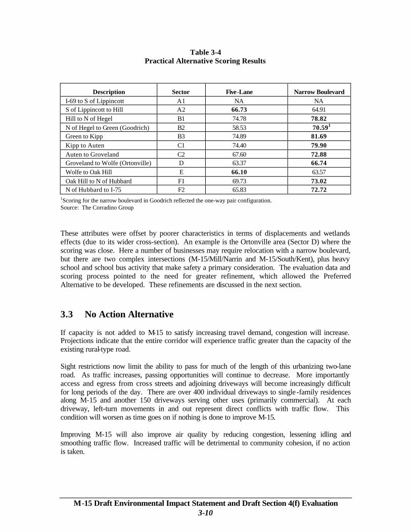
Table 3-4 Practical Alternative Scoring Results
Description Sector Five-Lane Narrow Boulevard I-69 to S of Lippincott A1 NA NA S of Lippincott to Hill A2 66.73 64.91 Hill to N of Hegel B1 74.78 78.82 N of Hegel to Green (Goodrich) B2 58.53 70.591 Green to Kipp B3 74.89 81.69 Kipp to Auten C1 74.40 79.90 Auten to Groveland C2 67.60 72.88 Groveland to Wolfe (Ortonville) D 63.37 66.74 Wolfe to Oak Hill E 66.10 63.57 Oak Hill to N of Hubbard F1 69.73 73.02 N of Hubbard to I-75 F2 65.83 72.72
1Scoring for the narrow boulevard in Goodrich reflected the one-way pair configuration. Source: The Corradino Group These attributes were offset by poorer characteristics in terms of displacements and wetlands effects (due to its wider cross-section). An example is the Ortonville area (Sector D) where the scoring was close. Here a number of businesses may require relocation with a narrow boulevard, but there are two complex intersections (M-15/Mill/Narrin and M-15/South/Kent), plus heavy school and school bus activity that make safety a primary consideration. The evaluation data and scoring process pointed to the need for greater refinement, which allowed the Preferred Alternative to be developed. These refinements are discussed in the next section. 3.3 No Action Alternative If capacity is not added to M-15 to satisfy increasing travel demand, congestion will increase. Projections indicate that the entire corridor will experience traffic greater than the capacity of the existing rural-type road. Sight restrictions now limit the ability to pass for much of the length of this urbanizing two-lane road. As traffic increases, passing opportunities will continue to decrease. More importantly access and egress from cross streets and adjoining driveways will become increasingly difficult for long periods of the day. There are over 400 individual driveways to single-family residences along M-15 and another 150 driveways serving other uses (primarily commercial). At each driveway, left-turn movements in and out represent direct conflicts with traffic flow. This condition will worsen as time goes on if nothing is done to improve M-15. Improving M-15 will also improve air quality by reducing congestion, lessening idling and smoothing traffic flow. Increased traffic will be detrimental to community cohesion, if no action is taken.

M-15 Draft Environmental Impact Statement and Draft Section 4(f) Evaluation 3-11
Doing-nothing will lead to crashes increasing at a faster rate than if the project were built. If nothing were done, it is estimated that there will be 707 crashes in 2025. It is estimated that with the implementation of the Preferred Alternative, M-15 will experience 644 crashes in 2025. If nothing were done there will be 145 dwelling units exposed to 66 dBA or more (residential noise criteria ). 3.4 Preferred Alternative The Preferred Alternative combines five-lane and boulevard sections to provide four through travel lanes over the 20-mile length of the corridor. Though a Preferred Alternative has been identified, the No Action Alternative remains an option. A final alternative will not be selected until after the public hearing and following comment period (60 days) are concluded and all comments have been considered. The cross section of a road should not change frequently to ensure effective movement of traffic. Thus, the following description reflects an effort to provide narrow boulevard sections of reasonable length, with five-lane road construction in locations where constraining circumstances, such as existing development, wetlands, and historic resources do not favor boulevard construction. In addition, where access is less critical, a “very narrow boulevard” is proposed to make the road as narrow as possible while preserving some of the safety and aesthetic benefits of the boulevard. From north to south the following mix of roadway types is proposed as the Preferred Alternative (Figure 1-2):
• I-69 to Maple – Five-lane, with a transition to narrow boulevard north of Maple Road. • Maple to north side of Goodrich – Narrow Boulevard, with a transition to five-lane road
north of East Hegel. • North side of Goodrich to Green - Five-lane, with a transition to narrow boulevard south
of Green. • Green to south of Auten – Narrow Boulevard. • South of Auten to south of Groveland – The recommendation is for very narrow
boulevard through this area (which includes a high-quality wetland and historic site) with transitions placed as needed. With little access needed on either side of the road, due to the presence of wetlands, a narrow, unbroken median is possible.
• South of Groveland to Brandon High School access road (south of Wolfe) – Narrow Boulevard, with transition to a five-lane section south of the school access road.
• Brandon High School access road to Seymour Lake Road – Five-lane, with transition to narrow boulevard north of Seymour Lake Road.
• Seymour Lake Road to Hubbard Road – Narrow Boulevard, with transition to very narrow boulevard just north of Hubbard Road.
• Hubbard Road to Cranberry Lake Road – Very Narrow Boulevard, with transition to five-lane road at Cranberry Lake Road.
• Cranberry Lake Road to I-75 – Five-lane. A narrow boulevard configuration would necessitate additional right-of-way acquisition, so it was not chosen. And, access needs are such that a center turn lane configuration is the practical solution in this area.
The sector descriptions above vary from the scoring preferences in Table 3-4 in several locations reflecting refinements that led to the Preferred Alternative:

M-15 Draft Environmental Impact Statement and Draft Section 4(f) Evaluation 3-12
• In Sector A2, the five-lane cross section was favored in the scoring. However, once past the heavy concentration of homes along M-15 north of Maple Road, there is no reason not to transition to a boulevard (Sector A2b). With the boulevard preferred for safety reasons, this change was made.
• In Sector B2, Goodrich, a one-way pair was favored in the scoring, but it presents some
difficulties. It was originally developed to avoid impacts to historic resources along M-15, as preliminary research indicated a five-lane widening would displace a property potentially eligible for the National Register of Historic Places. Further research found the candidate building is likely not eligible, so a prime reason for the one-way pair was not substantiated. Also, the Goodrich United Methodist Church, in conjunction with a private developer, indicated plans to build a 100-unit senior residence center on land that the one-way pair would occupy. It was uncertain whether the one-way pair could be made compatible with the senior center and other church plans. Finally, there are wetlands at the south end of the one-way pair’s northbound leg as well as platted subdivision lots. These lots may be built on before right-of-way acquisition could occur for improving M-15 thereby interfering with the roadway's development.
• In Sector E, the five-lane cross section was favored in the scoring. But, as in Sector A2
there is a subsection of the sector where a narrow boulevard could be constructed with relatively minor impacts compared to the five-lane. This is the section south of Seymour Lake Road (Sector E2).
• In Sector F2, construction of a boulevard (which was favored in scoring) is a complicated
issue. Independence Township favors construction of a boulevard and their master plan so indicates, but safety, access, and existing right-of-way must be considered. The proposed blend of boulevard and center turn lane construction is discussed below.
From Hubbard Road south, land use is essentially “built out,” with little new land available for development. Consequently, as the roadway type was considered in this area, maintaining existing right-of-way limits had priority. The question was what kind of boulevard could be constructed in 120 feet of right-of-way? The very narrow boulevard is the answer. It calls for narrowing the typical section to look like the five-lane, except with a grass median rather than a paved turn-lane in the middle. Very narrow boulevard construction can occur without conflict south to Cranberry Lake Road. Full intersections with left-turn lanes are required in this section because “Michigan” left turns (right turn from the side street, then a U-turn) cannot be accommodated in the 120 feet. With or without the boulevard, left turns out of the gas station in the northeast quadrant of the interchange should not be allowed. Motorists will invariably attempt to reach the northbound interstate on-ramp. To do so would require crossing the throat of the ramp at a point past where the ramp separates from the lanes of M-15.
3.4.1 Typical Sections The typical roadway sections are presented in Figure 3-5, which includes photos of representative examples of such roads. Most of the project will be of rural design with a paved shoulder and then a gentle slope (usually a ratio of 1:6) to a ditch. The typical section for a narrow boulevard

M-15 Draft Environmental Impact Statement and Draft Section 4(f) Evaluation 3-13

M-15 Draft Environmental Impact Statement and Draft Section 4(f) Evaluation 3-14
would require 172 feet of right-of-way. The five-lane road would require 120 feet of right-of-way. In developed areas the drainage would be collected with a curb and gutter to minimize right-of-way acquisition. Travel lanes would normally be 12 feet. In some curb-and-gutter sections, a wide curb lane may substitute for a paved shoulder for use by bicycles. In more built-up areas safety paths (sidewalks) would be provided, normally separated from the road by at least 8 feet. The median of the boulevard would generally be 40 feet wide and there would also be inside and outside shoulders. If there were no access needs (driveways and cross roads), the median would be narrowed wherever there are constraining circumstances, such as wetlands or historic resources, or simply existing development. Examples are the wetland area north of Groveland Road and the section between Hubbard and Cranberry Lake Roads. In addition to narrowing the median in wetland areas, the side-slopes will be more steep and guard rails installed to minimize wetland impacts. The five-lane road through Goodrich would be narrowed as much as possible in keeping with design standards. A 93-foot right-of-way is planned in this section. Lanes as narrow as 11 feet may be appropriate. 3.4.2 U-turn Channels and Loons U-turn channels are planned at intervals of no more than 1000 feet in boulevard sections. Their function supports access management. Left turns from some side streets and driveways are not allowed. Instead drivers will turn right, then use the next U-turn channel to complete the “left” turn. Where the width of the median is inadequate for a U-turn by a large vehicle, a “loon” will be provided. The narrow boulevard is sufficiently wide (172 feet) to allow the U-turn, if the shoulder is used. Where the road is narrowed further, additional pavement would be required (a “loon”). At this planning stage, the design principle is that the median will only be narrowed where no side-of-the-road access is required; so few loons are likely along the entire route. 3.4.3 Interchange at I-75 Improvements may be warranted over the long term at the M-15/I-75 interchange. In the morning peak, southbound traffic on M-15 trying to get onto southbound I-75 backs up to the intersections of Amy Drive and Cranberry Lake Road. Backups could be reduced by improving the taper of the southbound on-ramp from southbound M-15. Extending that ramp would also necessitate relocating the ramp from northbound M-15 to southbound I-75. It is noted that independent planning is underway for an additional travel lane on I-75 in each direction. In the afternoon peak hour, traffic sometimes backs up onto I-75 at the northbound exit to M-15. Additional storage could be created on the off-ramp to M-15 by lengthening the ramp. Adding or modifying interchanges on the Interstate system requires preparation of an Interchange Justification Study for approval by the Federal Highway Administration; however, the minor changes proposed here do not change the configurations of the interchanges and hence do not require such studies or approvals.