sandwich pedestrian/bicycle planning - cape cod … · introduction ... the bicycle feasibility...
TRANSCRIPT
Sandwich Pedestrian/Bicycle Planning - 2014
Sandwich Pedestrian/Bicycle Planning Improved Pedestrian and Bicycle Connections with the Cape Cod Canal Multi-use Path
February 2014

Sandwich Pedestrian/Bicycle Planning - 2014
Sandwich Pedestrian/Bicycle Planning - 2014
Table of Contents
Introduction ........................................................................................................................... 1
Background ........................................................................................................................ 1
Study Goals ........................................................................................................................ 3
Metohodolgy for Development of Alternatives ................................................................. 4
Activity Centers .................................................................................................................. 4
Overview of Existing Conditions ........................................................................................... 5
Crash History ..................................................................................................................... 5
Limited Sidewalks .............................................................................................................. 5
Development of Alternatives ................................................................................................. 7
Public Workshop One ........................................................................................................ 7
Public Workshop Two ...................................................................................................... 12
Jarves Street Options Meeting ........................................................................................ 23
Conclusion/Recommendations ........................................................................................... 25
Conclusion ........................................................................................................................ 27
List of Figures Figure 1 - Regional Bike Routes ............................................................................................ 2
Figure 2 - Local Bike Routes ................................................................................................. 3
Figure 3 - Sidewalk Inventory ............................................................................................... 6
Figure 4 - Initial Route Proposals, Workshop 1 ................................................................... 8
Sandwich Pedestrian/Bicycle Planning - 2014
Figure 5 - Merchant Square Concept D ................................................................................ 9
Figure 6 - Merchant Square Plan Details ............................................................................ 10
Figure 7 - Merchant Square Visualization ........................................................................... 11
Figure 8 - Alignment Options, Workshop Two .................................................................. 14
Figure 9 - Alignment A Site Views and Cross-Sections ..................................................... 15
Figure 10 - Alignment B Site View ...................................................................................... 16
Figure 11 - Alignments B & C .............................................................................................. 17
Figure 12 - Alignment D - Site View and Cross-Sections ................................................... 18
Figure 13 - Alignment E Site View and Cross-Sections ...................................................... 19
Figure 14 - Alignment F Cross-Sections .............................................................................20
Figure 15 - Alignment G Site View ...................................................................................... 21
Figure 16 - Informational Signage - Cape Cod Canal Kiosk ............................................... 22
Figure 17 - Site View at Jarves Street .................................................................................. 23
Figure 18 - Jarves Street Cross-Sections............................................................................. 24
Figure 19 Recommended Route Proposals ......................................................................... 25
List of Tables
Table 1 - Crash History .......................................................................................................... 5
Table 2 - Alignment Option Pro's and Con's, Workshop Two ........................................... 13
Table 3 - Conceptual Cost Estimates .................................................................................. 26
Sandwich Pedestrian/Bicycle Planning - 2014 1 | P a g e
Introduction BACKGROUND
Cape-wide bicycle and pedestrian planning was explored in the 2010 Bicycle Feasibility Study: Integrated Bicycle Plan for Cape Cod. This feasibility study was undertaken by the National Park Service in partnership with the Cape Cod Commission to identify improvements necessary to develop an integrated bicycle network throughout Cape Cod. This plan will help to ensure an efficient, coordinated approach to addressing needed bicycle network improvements. Improvements recommended in this study are as follows:
1. Interpretive signage for the kiosk at the end of the Canal Path near the Marina. 2. Completion of the bike route between the Canal and Tupper Road. 3. Install a crosswalk across Tupper Road at Freezer Road. 4. Develop the connection from Freezer Road to Route 6A. 5. Strategies for Jarves Street need some more public discussion before a strategy
can be developed. The proposed bike/pedestrian options for this roadway segment needs to be examined in terms of traffic and parking impacts.
With active participation of Cape Cod Commission staff and many other stakeholders, the study helps lay the groundwork needed to improve bicycling conditions on Cape Cod by developing a comprehensive and connected bicycle network. The plan included a list of both infrastructure improvements and programmatic initiatives to promote bicycling, enhance bicycle access and improve safety. These improvements are expected to help establish bicycling as a viable transportation option while reducing dependence on automobile transportation. This is to be accomplished by creating an integrated, multimodal transportation environment throughout Cape Cod. The study established an approach to identifying opportunities for projects and initiatives, and provides guidance on implementing them in an efficient and coordinated manner.
The feasibility plan included 47 priority projects and a number of regional routes that converged on Sandwich as well as local concepts which lead to the demand for this study. The 2010 Bicycle Feasibility Study: Integrated Bicycle Plan for Cape Cod also identified the Sandwich Marina area as a potential regional hub for bicycling on Cape Cod. Additional planning also supported investigation of bicycle and pedestrian potential in this area.
Sandwich hosts a portion of the Army Corps of Engineers’ (ACOE) Cape Cod Canal Service Road commonly referred to as “the Cape Cod Canal Bike Path.” This Canal multi-use path runs along the southern edge of the Cape Cod Canal and ends at the Sandwich Marina near several business areas.
P a g e | 2 Sandwich Pedestrian/Bicycle Planning - 2014
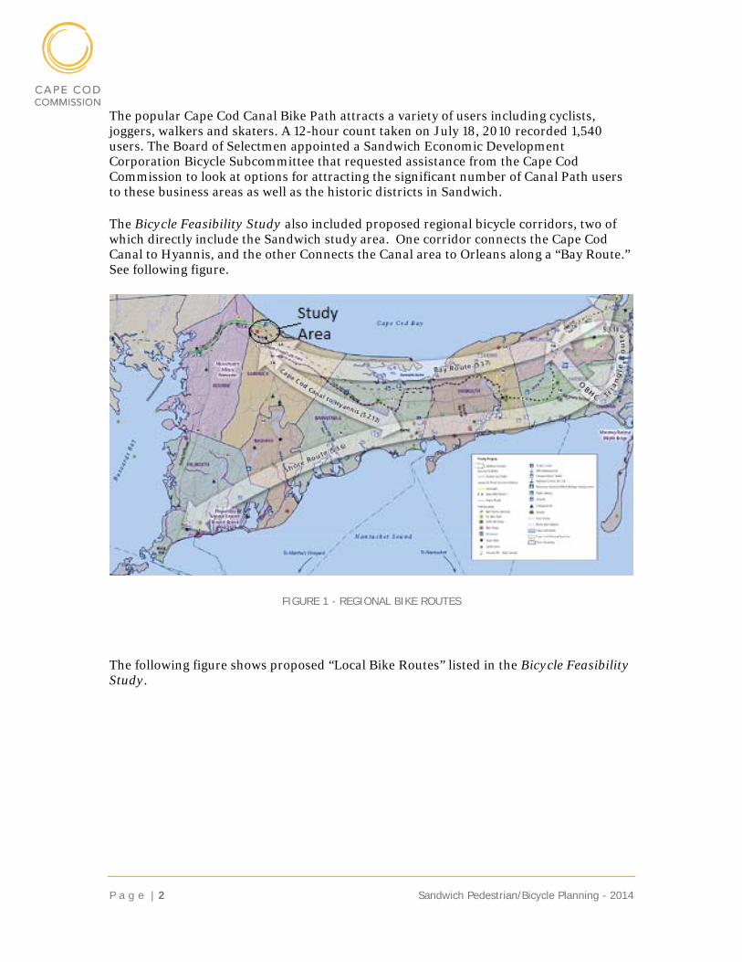
The popular Cape Cod Canal Bike Path attracts a variety of users including cyclists, joggers, walkers and skaters. A 12-hour count taken on July 18, 2010 recorded 1,540 users. The Board of Selectmen appointed a Sandwich Economic Development Corporation Bicycle Subcommittee that requested assistance from the Cape Cod Commission to look at options for attracting the significant number of Canal Path users to these business areas as well as the historic districts in Sandwich.
The Bicycle Feasibility Study also included proposed regional bicycle corridors, two of which directly include the Sandwich study area. One corridor connects the Cape Cod Canal to Hyannis, and the other Connects the Canal area to Orleans along a “Bay Route.” See following figure.
FIGURE 1 - REGIONAL BIKE ROUTES
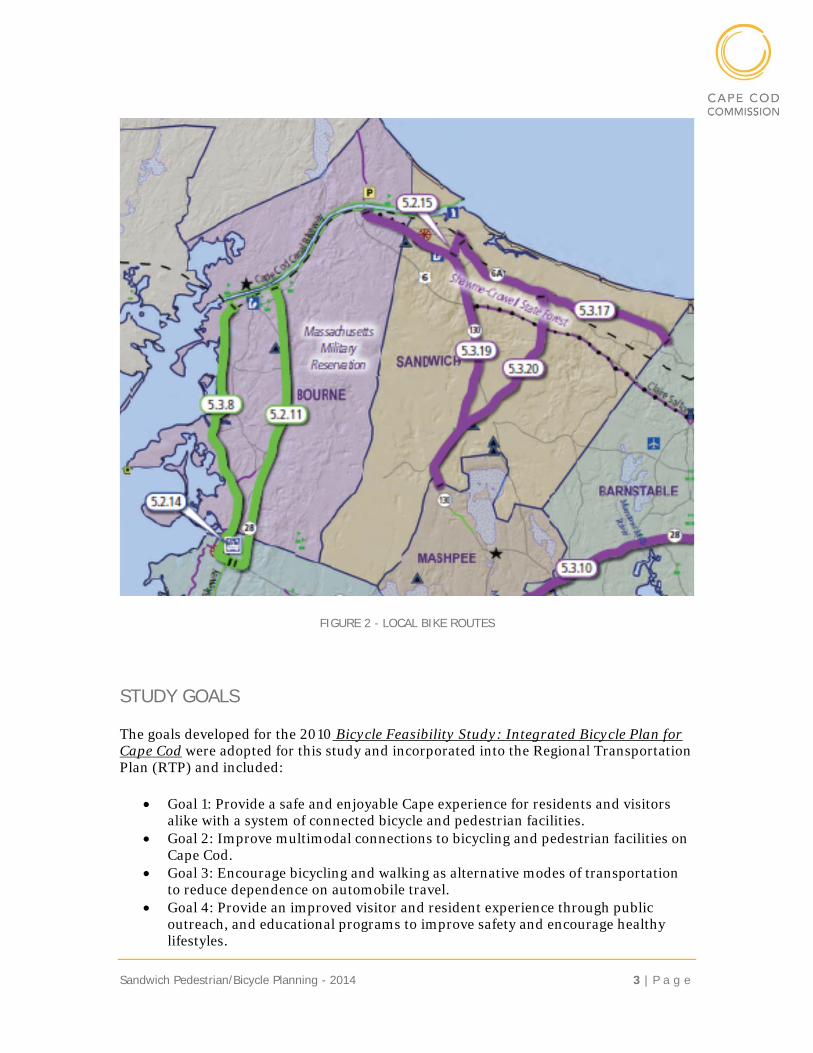
The following figure shows proposed “Local Bike Routes” listed in the Bicycle Feasibility Study.
Sandwich Pedestrian/Bicycle Planning - 2014 3 | P a g e
FIGURE 2 - LOCAL BIKE ROUTES
STUDY GOALS
The goals developed for the 2010 Bicycle Feasibility Study: Integrated Bicycle Plan for Cape Cod were adopted for this study and incorporated into the Regional Transportation Plan (RTP) and included:
Goal 1: Provide a safe and enjoyable Cape experience for residents and visitors alike with a system of connected bicycle and pedestrian facilities.
Goal 2: Improve multimodal connections to bicycling and pedestrian facilities on Cape Cod.
Goal 3: Encourage bicycling and walking as alternative modes of transportation to reduce dependence on automobile travel.
Goal 4: Provide an improved visitor and resident experience through public outreach, and educational programs to improve safety and encourage healthy lifestyles.
P a g e | 4 Sandwich Pedestrian/Bicycle Planning - 2014
Goal 5: Avoid and/or mitigate adverse environmental impacts of proposed improvements, while seeking ways to realize positive environmental enhancements.
Goal 6: Capitalize on opportunities to improve bicycle and pedestrian networks through planned construction or maintenance.
Goal 7: Based on the Upper Cape’s location as the gateway to Cape Cod, build public awareness that this area is the foundation of making Cape Cod a nationally recognized bike-friendly area.
Additionally, it is important that bicycling planners work with the Cape Cod Regional Transit Authority to provide sufficient bike transport capacity and transit service, especially during the busy summer season.
METOHODOLGY FOR DEVELOPMENT OF ALTERNATIVES
The development of alternatives was based on several public meetings and two workshops. The initial meetings focused on the identification of:
Activity Centers o Bicycle and Pedestrian Destinations
Issue Areas o Safety o Environmental o Other
Additional Ideas Local/Regional Connections Needed Sidewalk Locations
ACTIVITY CENTERS
The project was initiated with the focus on attracting the many users of the Cape Cod Canal Bike Path to Merchant’s Square, a commercial area with a variety of shops and restaurants. Discussions with the bicycle committee quickly expanded the scope of the study to include the Sandwich Historic District and other commercial areas and attractions.
Primary destinations included: Merchant’s Square The Sandwich Marina The Sandwich Boardwalk Commercial development at Rte. 6A and Tupper Road Jarvesville – which has recently been designated as a historic district Historic Sandwich Center The Sandwich Glass Museum The Wing School
Sandwich Pedestrian/Bicycle Planning - 2014 5 | P a g e
Overview of Existing Conditions CRASH HISTORY
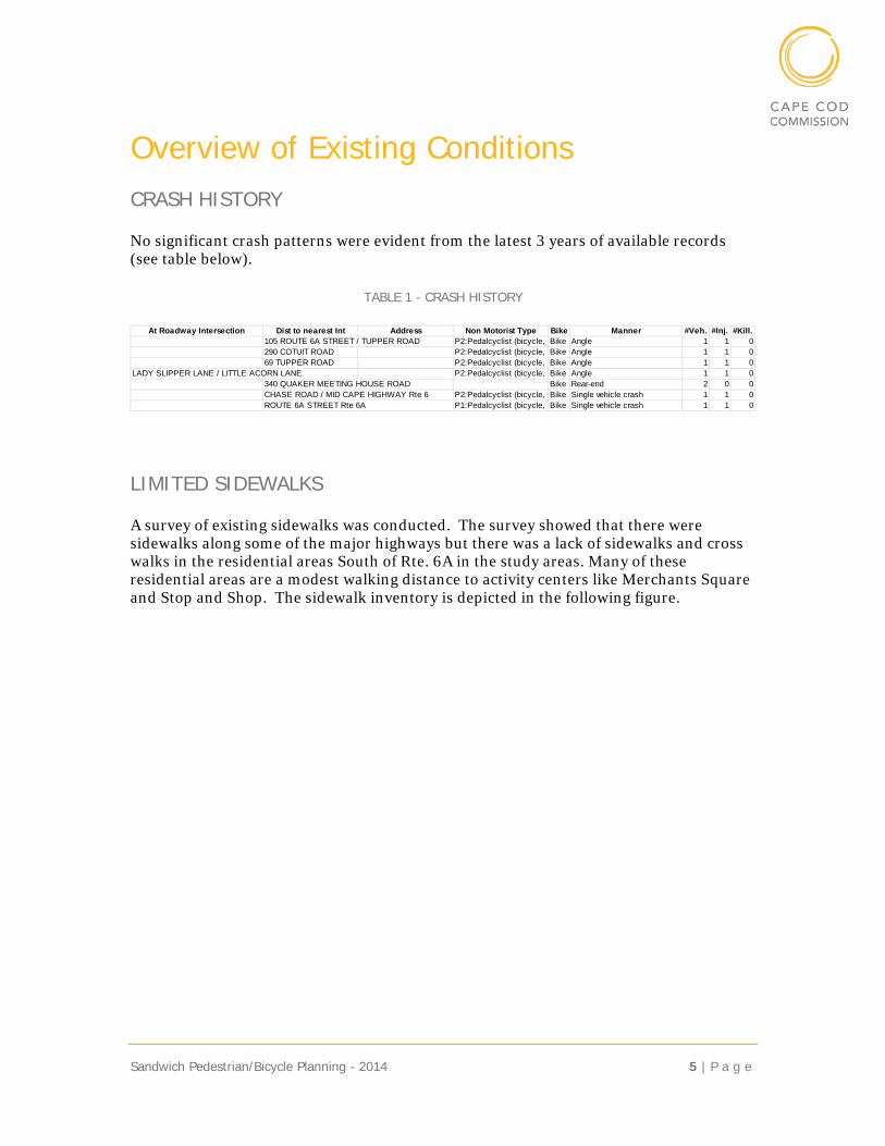
No significant crash patterns were evident from the latest 3 years of available records (see table below).
TABLE 1 - CRASH HISTORY
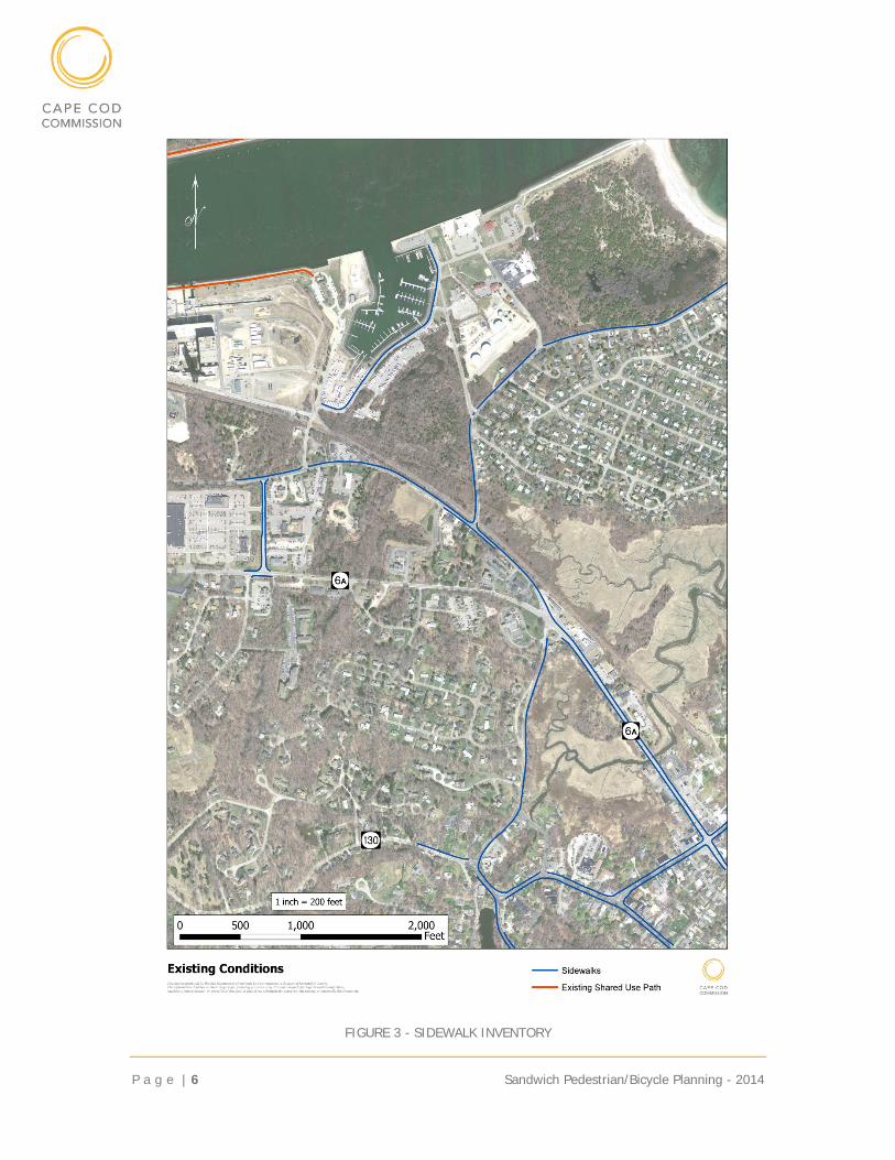
LIMITED SIDEWALKS
A survey of existing sidewalks was conducted. The survey showed that there were sidewalks along some of the major highways but there was a lack of sidewalks and cross walks in the residential areas South of Rte. 6A in the study areas. Many of these residential areas are a modest walking distance to activity centers like Merchants Square and Stop and Shop. The sidewalk inventory is depicted in the following figure.
At Roadway Intersection Dist to nearest Int Address Non Motorist Type Bike Manner #Veh. #Inj. #Kill.105 ROUTE 6A STREET / TUPPER ROAD P2:Pedalcyclist (bicycle, tBike Angle 1 1 0290 COTUIT ROAD P2:Pedalcyclist (bicycle, tBike Angle 1 1 069 TUPPER ROAD P2:Pedalcyclist (bicycle, tBike Angle 1 1 0
LADY SLIPPER LANE / LITTLE ACORN LANE P2:Pedalcyclist (bicycle, tBike Angle 1 1 0340 QUAKER MEETING HOUSE ROAD Bike Rear-end 2 0 0CHASE ROAD / MID CAPE HIGHWAY Rte 6 P2:Pedalcyclist (bicycle, tBike Single vehicle crash 1 1 0ROUTE 6A STREET Rte 6A P1:Pedalcyclist (bicycle, tBike Single vehicle crash 1 1 0
P a g e | 6 Sandwich Pedestrian/Bicycle Planning - 2014
FIGURE 3 - SIDEWALK INVENTORY
Sandwich Pedestrian/Bicycle Planning - 2014 7 | P a g e
Development of Alternatives The following sections describe the development of alternatives that occurred during a series of public workshops.
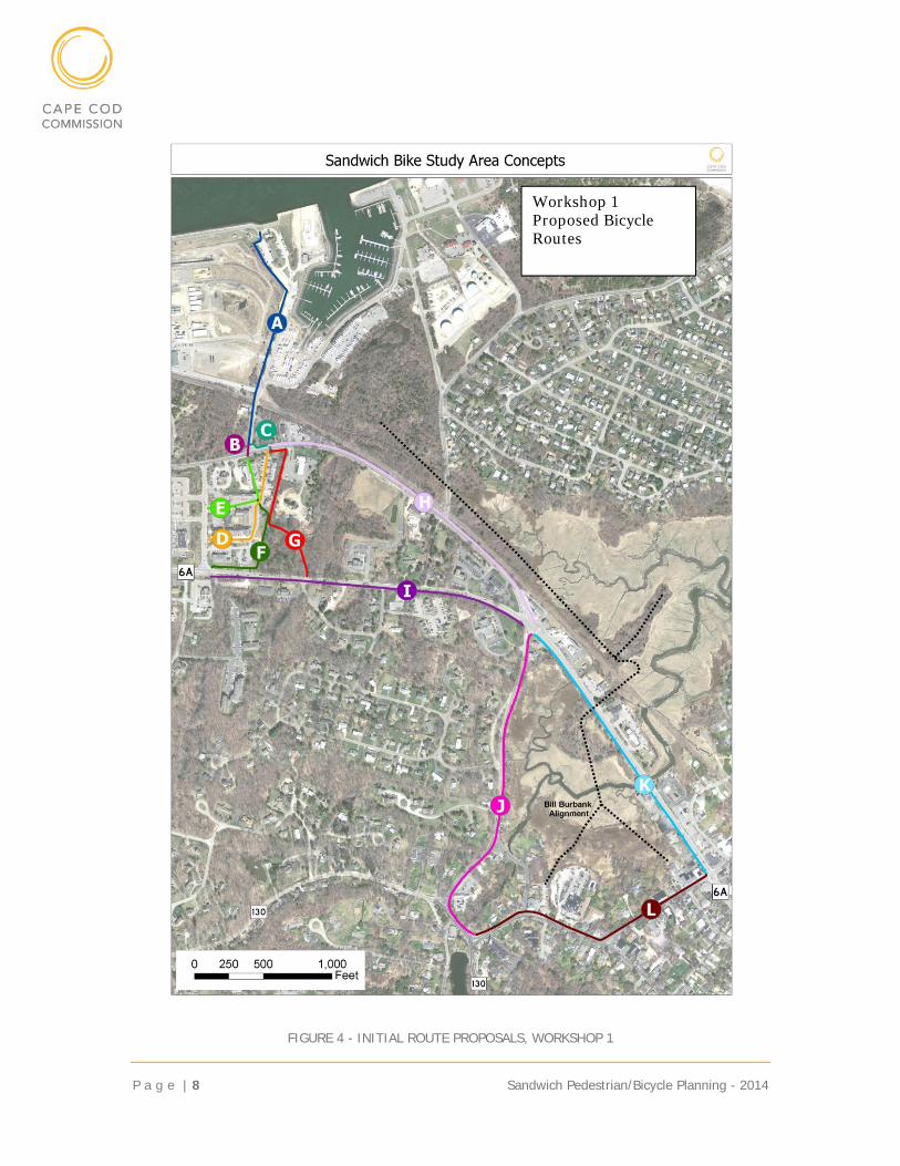
PUBLIC WORKSHOP ONE
The project was discussed at several Sandwich Bicycle subcommittees before the first public workshop on March 4, 2011, primarily with the business owners in the Merchant’s Square Shopping Center. The intent of this first workshop was to present a number of preliminary concepts including an update of the shopping center concepts and receive feedback.
The preliminary alignments that were presented are shown in the following figure:
P a g e | 8 Sandwich Pedestrian/Bicycle Planning - 2014
FIGURE 4 - INITIAL ROUTE PROPOSALS, WORKSHOP 1
Workshop 1 Proposed Bicycle Routes
Sandwich Pedestrian/Bicycle Planning - 2014 9 | P a g e
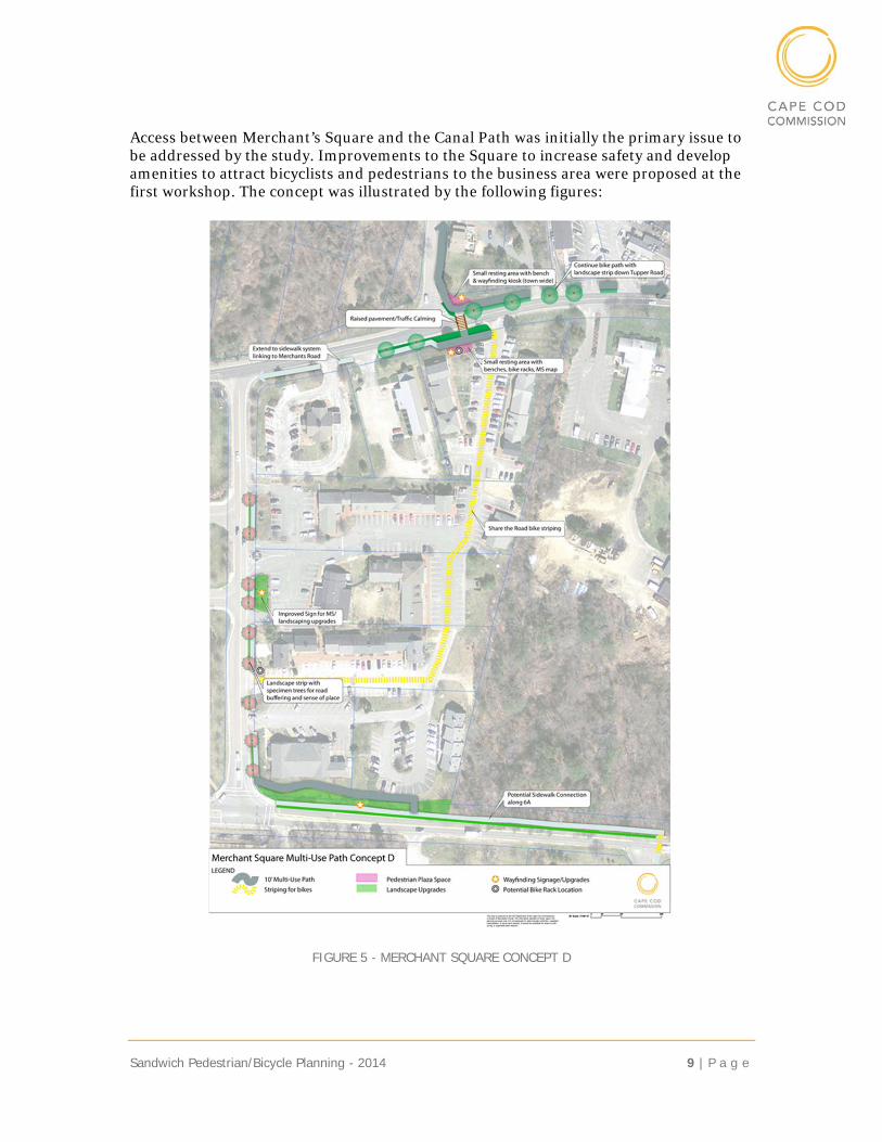
Access between Merchant’s Square and the Canal Path was initially the primary issue to be addressed by the study. Improvements to the Square to increase safety and develop amenities to attract bicyclists and pedestrians to the business area were proposed at the first workshop. The concept was illustrated by the following figures:
FIGURE 5 - MERCHANT SQUARE CONCEPT D
P a g e | 10 Sandwich Pedestrian/Bicycle Planning - 2014
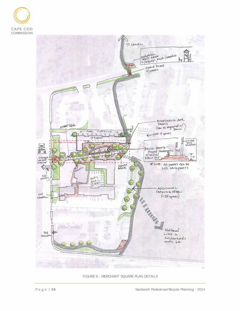
FIGURE 6 - MERCHANT SQUARE PLAN DETAILS
Sandwich Pedestrian/Bicycle Planning - 2014 11 | P a g e
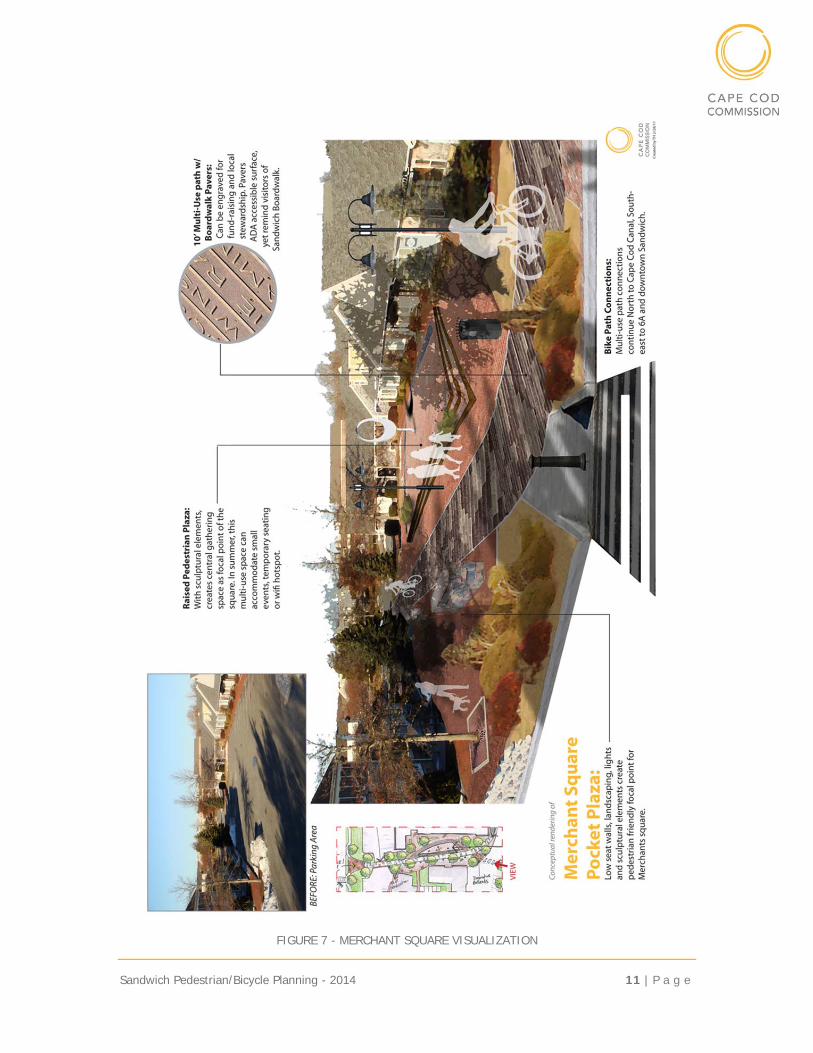
FIGURE 7 - MERCHANT SQUARE VISUALIZATION
P a g e | 12 Sandwich Pedestrian/Bicycle Planning - 2014
The workshop provided guidance with respect to the preliminary proposals. Key comments included:
Continue to develop the alignments as presented. Funding sources for the improvements to Merchants Square are unlikely so more
modest improvements should be considered. Parking is critical – improvements should not decrease available parking. Provide a parking area for cyclists and pedestrians near the Canal Path. Develop low cost, implementable solutions as an initial phase of the project.
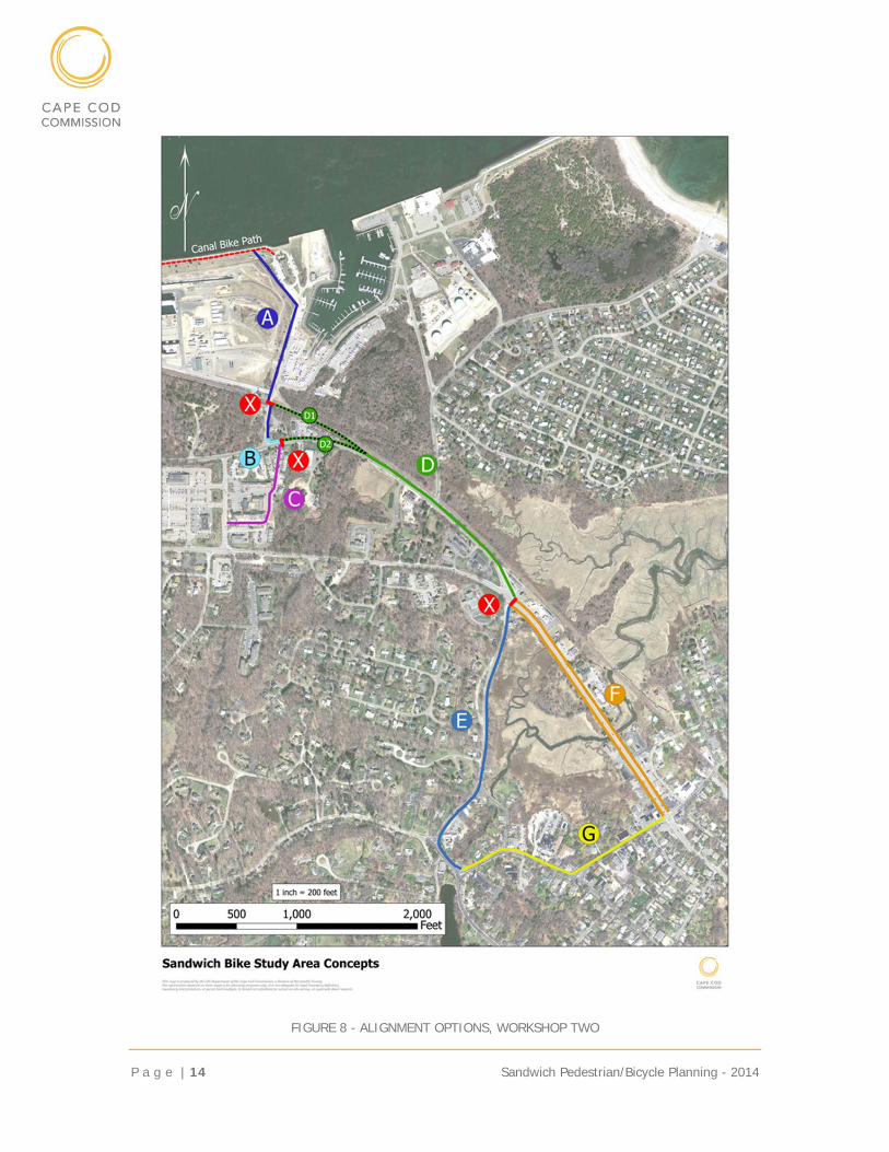
PUBLIC WORKSHOP TWO
Commission staff refined the alignments based on comments received at Workshop One and developed preliminary cost estimates for the project for discussion at a workshop on June 28, 2011. Further investigation of the originally proposed alignments resulted in the elimination or modification of several.
The “Bill Burbank Alignment” proposed by others that provided a boardwalk across the Great Marsh and access to Brady’s Island was considered infeasible for permitting and financial reasons.
Crossing of Tupper Road to provide a link to Merchant’s Square and alignment “B” was eliminated as alignment “C” was preferred.
Internal alignment “E” for Merchant’s Square was eliminated due to consumption of existing parking.
Exterior alignment “F” for Merchant’s Square was eliminated as not cost effective.
Water District Path “G” was eliminated as the Water District was unwilling to provide the right of way required to support the path.
The following revised alignments were presented to receive additional public input and to develop consensus. The revised options were given new letter designation as follows with the “X”s indicating improved cross walks. The Commission team also provided a matrix to describe the alignments including “pros and cons” as shown in the following table. The Concepts are shown on the following figure.
Sandwich Pedestrian/Bicycle Planning - 2014 13 | P a g e
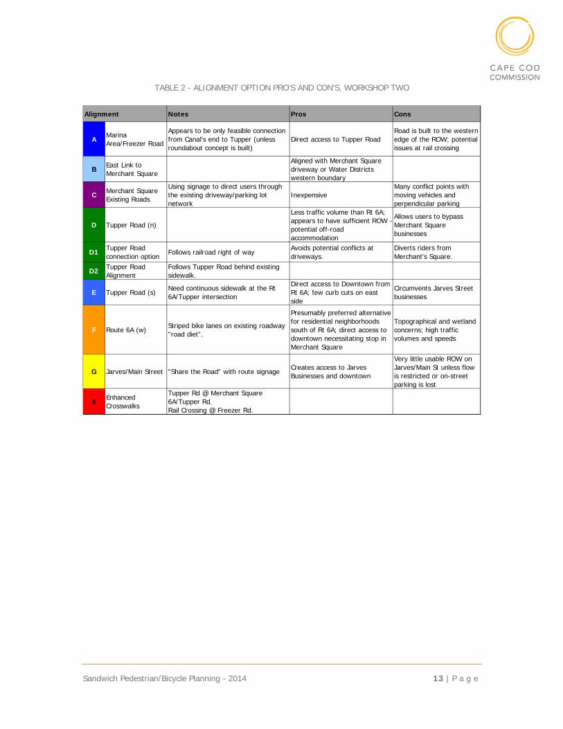
TABLE 2 - ALIGNMENT OPTION PRO'S AND CON'S, WORKSHOP TWO
Alignment Notes Pros Cons
A Marina Area/Freezer Road
Appears to be only feasible connection from Canal's end to Tupper (unless roundabout concept is built)
Direct access to Tupper RoadRoad is built to the western edge of the ROW; potential issues at rail crossing
B East Link to Merchant Square
Aligned with Merchant Square driveway or Water Districts western boundary
C Merchant Square Existing Roads
Using signage to direct users through the existing driveway/parking lot network
InexpensiveMany conflict points with moving vehicles and perpendicular parking
D Tupper Road (n)
Less traffic volume than Rt 6A; appears to have sufficient ROW - potential off-road accommodation
Allows users to bypass Merchant Square businesses
D1 Tupper Road connection option
Follows railroad right of way Avoids potential conflicts at driveways.
Diverts riders from Merchant's Square.
D2 Tupper Road Alignment
Follows Tupper Road behind existing sidewalk.
E Tupper Road (s) Need continuous sidewalk at the Rt 6A/Tupper intersection
Direct access to Downtown from Rt 6A; few curb cuts on east side
Circumvents Jarves Street businesses
F Route 6A (w) Striped bike lanes on existing roadway "road diet".
Presumably preferred alternative for residential neighborhoods south of Rt 6A; direct access to downtown necessitating stop in Merchant Square
Topographical and wetland concerns; high traffic volumes and speeds
G Jarves/Main Street "Share the Road" with route signage Creates access to Jarves Businesses and downtown
Very little usable ROW on Jarves/Main St unless flow is restricted or on-street parking is lost
X Enhanced Crosswalks
Tupper Rd @ Merchant Square 6A/Tupper Rd.Rail Crossing @ Freezer Rd.
P a g e | 14 Sandwich Pedestrian/Bicycle Planning - 2014
FIGURE 8 - ALIGNMENT OPTIONS, WORKSHOP TWO
Sandwich Pedestrian/Bicycle Planning - 2014 15 | P a g e
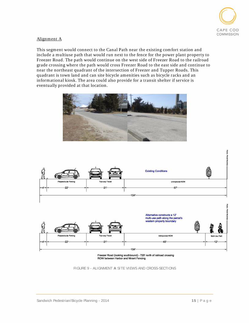
Alignment A
This segment would connect to the Canal Path near the existing comfort station and include a multiuse path that would run next to the fence for the power plant property to Freezer Road. The path would continue on the west side of Freezer Road to the railroad grade crossing where the path would cross Freezer Road to the east side and continue to near the northeast quadrant of the intersection of Freezer and Tupper Roads. This quadrant is town land and can site bicycle amenities such as bicycle racks and an informational kiosk. The area could also provide for a transit shelter if service is eventually provided at that location.
FIGURE 9 - ALIGNMENT A SITE VIEWS AND CROSS-SECTIONS
P a g e | 16 Sandwich Pedestrian/Bicycle Planning - 2014
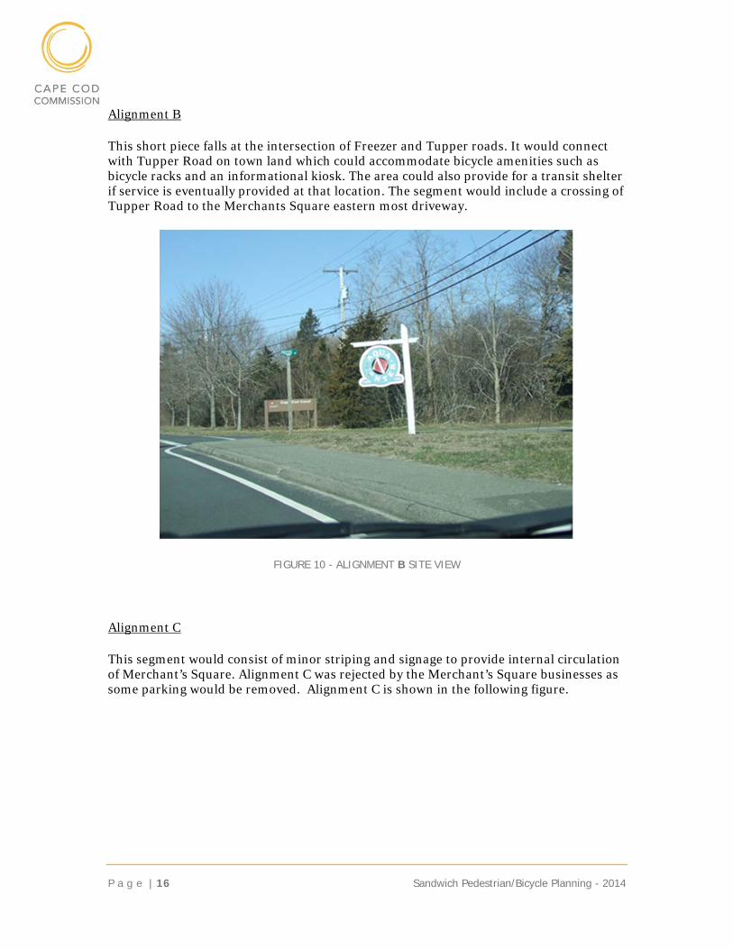
Alignment B
This short piece falls at the intersection of Freezer and Tupper roads. It would connect with Tupper Road on town land which could accommodate bicycle amenities such as bicycle racks and an informational kiosk. The area could also provide for a transit shelter if service is eventually provided at that location. The segment would include a crossing of Tupper Road to the Merchants Square eastern most driveway.
FIGURE 10 - ALIGNMENT B SITE VIEW
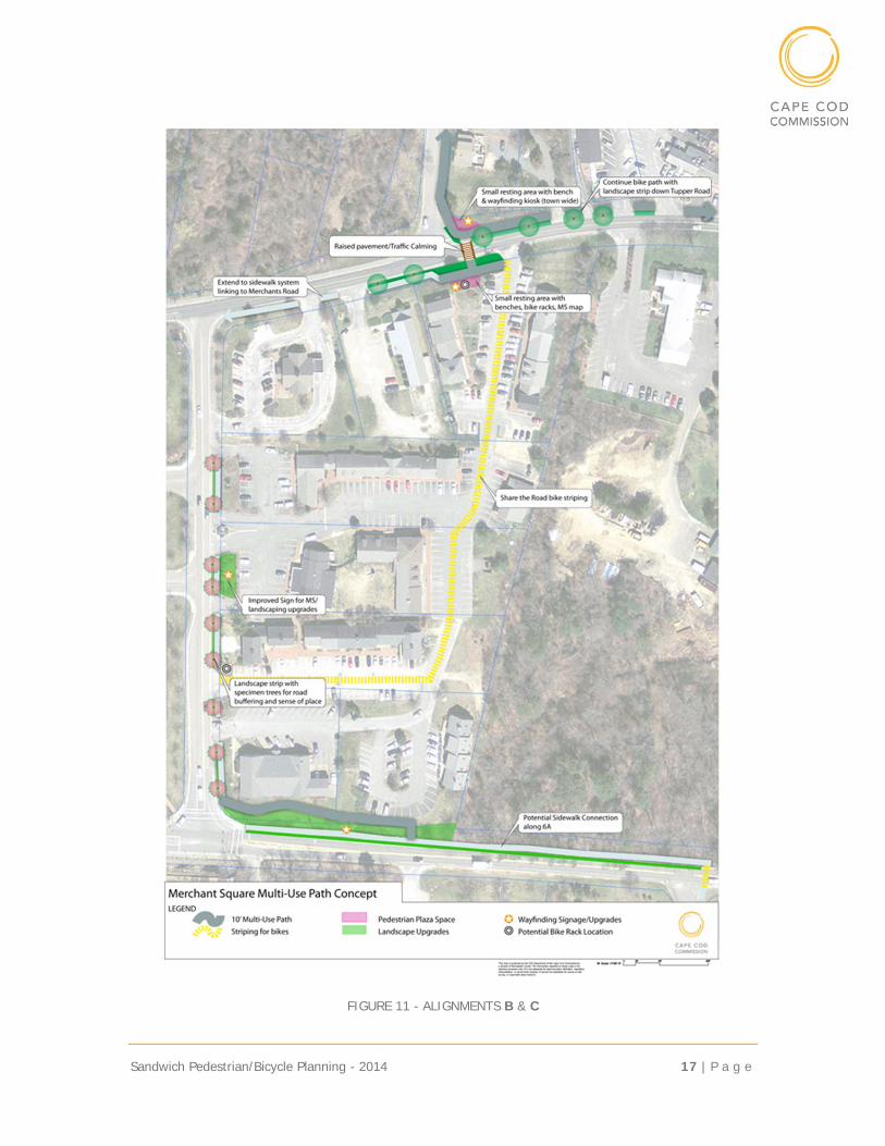
Alignment C
This segment would consist of minor striping and signage to provide internal circulation of Merchant’s Square. Alignment C was rejected by the Merchant’s Square businesses as some parking would be removed. Alignment C is shown in the following figure.
Sandwich Pedestrian/Bicycle Planning - 2014 17 | P a g e
FIGURE 11 - ALIGNMENTS B & C
P a g e | 18 Sandwich Pedestrian/Bicycle Planning - 2014
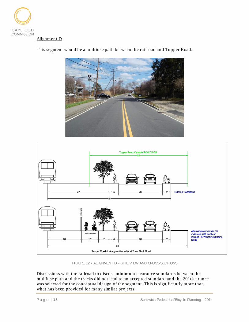
Alignment D
This segment would be a multiuse path between the railroad and Tupper Road.
FIGURE 12 - ALIGNMENT D - SITE VIEW AND CROSS-SECTIONS
Discussions with the railroad to discuss minimum clearance standards between the multiuse path and the tracks did not lead to an accepted standard and the 20’ clearance was selected for the conceptual design of the segment. This is significantly more than what has been provided for many similar projects.
Sandwich Pedestrian/Bicycle Planning - 2014 19 | P a g e
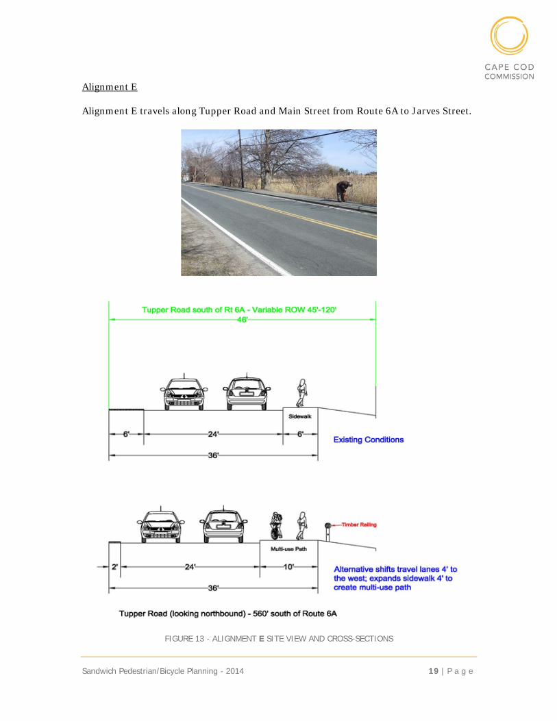
Alignment E
Alignment E travels along Tupper Road and Main Street from Route 6A to Jarves Street.
FIGURE 13 - ALIGNMENT E SITE VIEW AND CROSS-SECTIONS
P a g e | 20 Sandwich Pedestrian/Bicycle Planning - 2014
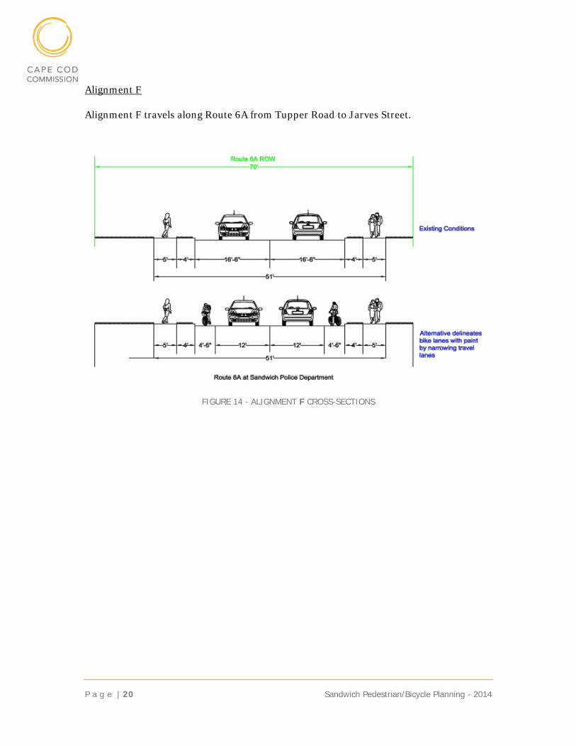
Alignment F
Alignment F travels along Route 6A from Tupper Road to Jarves Street.
FIGURE 14 - ALIGNMENT F CROSS-SECTIONS
Sandwich Pedestrian/Bicycle Planning - 2014 21 | P a g e
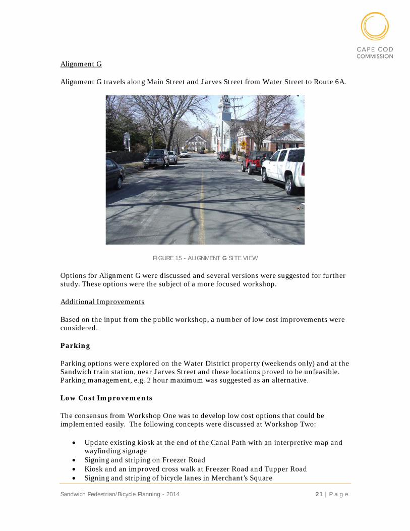
Alignment G
Alignment G travels along Main Street and Jarves Street from Water Street to Route 6A.
FIGURE 15 - ALIGNMENT G SITE VIEW
Options for Alignment G were discussed and several versions were suggested for further study. These options were the subject of a more focused workshop.
Additional Improvements
Based on the input from the public workshop, a number of low cost improvements were considered.
Parking
Parking options were explored on the Water District property (weekends only) and at the Sandwich train station, near Jarves Street and these locations proved to be unfeasible. Parking management, e.g. 2 hour maximum was suggested as an alternative.
Low Cost Improvements
The consensus from Workshop One was to develop low cost options that could be implemented easily. The following concepts were discussed at Workshop Two:
Update existing kiosk at the end of the Canal Path with an interpretive map and wayfinding signage
Signing and striping on Freezer Road Kiosk and an improved cross walk at Freezer Road and Tupper Road Signing and striping of bicycle lanes in Merchant’s Square
P a g e | 22 Sandwich Pedestrian/Bicycle Planning - 2014
Share the road signs Restriping Rte. 6A for a “road diet”
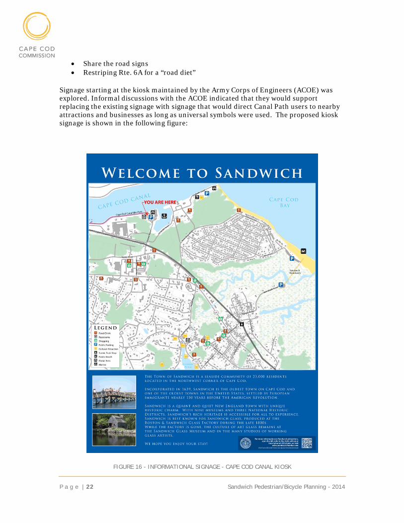
Signage starting at the kiosk maintained by the Army Corps of Engineers (ACOE) was explored. Informal discussions with the ACOE indicated that they would support replacing the existing signage with signage that would direct Canal Path users to nearby attractions and businesses as long as universal symbols were used. The proposed kiosk signage is shown in the following figure:
FIGURE 16 - INFORMATIONAL SIGNAGE - CAPE COD CANAL KIOSK
Sandwich Pedestrian/Bicycle Planning - 2014 23 | P a g e
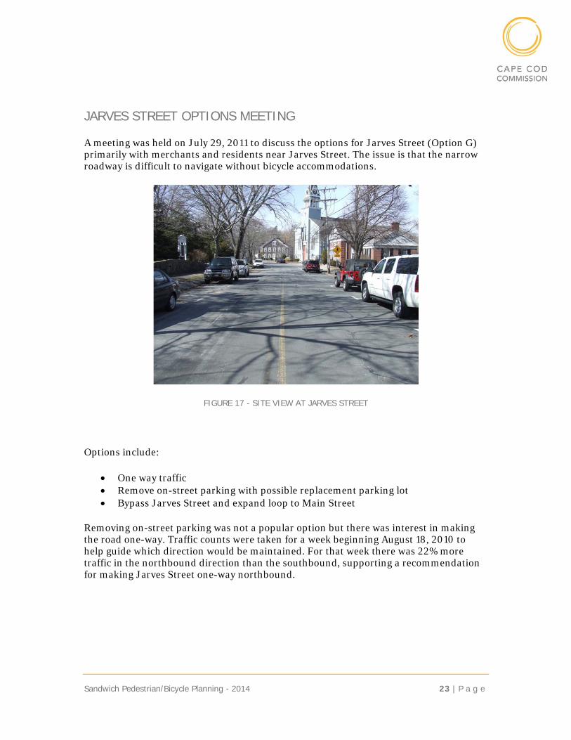
JARVES STREET OPTIONS MEETING
A meeting was held on July 29, 2011 to discuss the options for Jarves Street (Option G) primarily with merchants and residents near Jarves Street. The issue is that the narrow roadway is difficult to navigate without bicycle accommodations.
FIGURE 17 - SITE VIEW AT JARVES STREET
Options include:
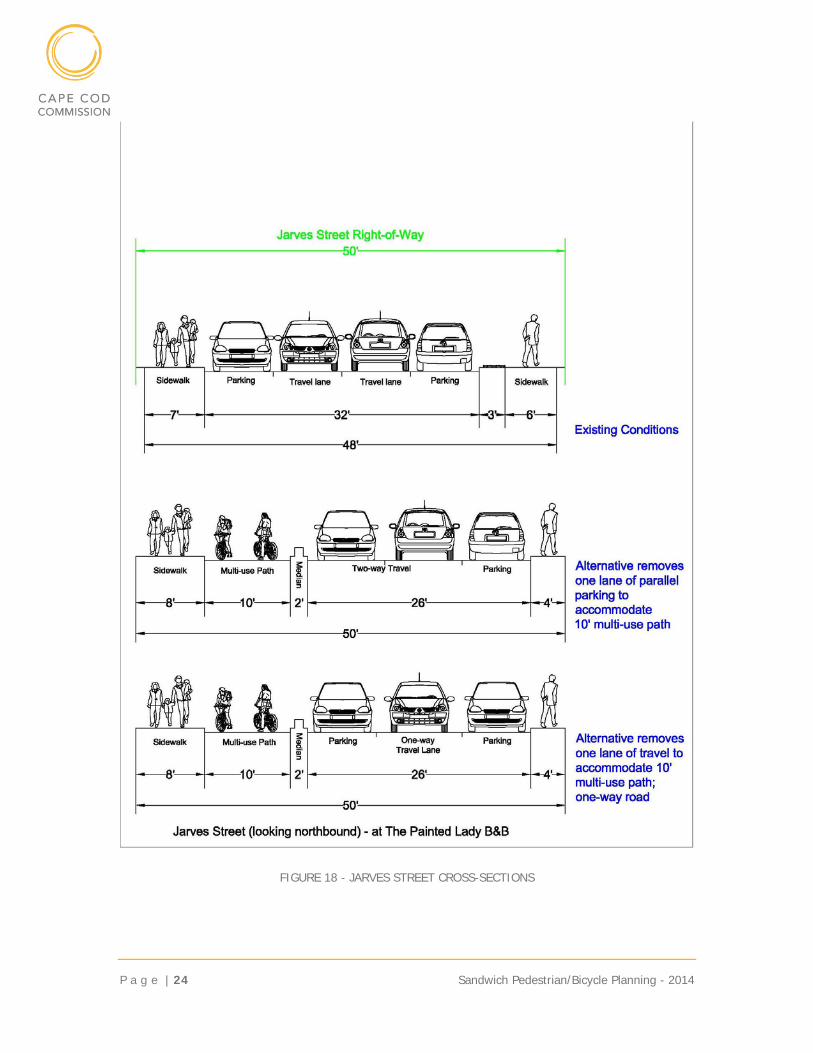
One way traffic Remove on-street parking with possible replacement parking lot Bypass Jarves Street and expand loop to Main Street
Removing on-street parking was not a popular option but there was interest in making the road one-way. Traffic counts were taken for a week beginning August 18, 2010 to help guide which direction would be maintained. For that week there was 22% more traffic in the northbound direction than the southbound, supporting a recommendation for making Jarves Street one-way northbound.
P a g e | 24 Sandwich Pedestrian/Bicycle Planning - 2014
FIGURE 18 - JARVES STREET CROSS-SECTIONS
Sandwich Pedestrian/Bicycle Planning - 2014 25 | P a g e
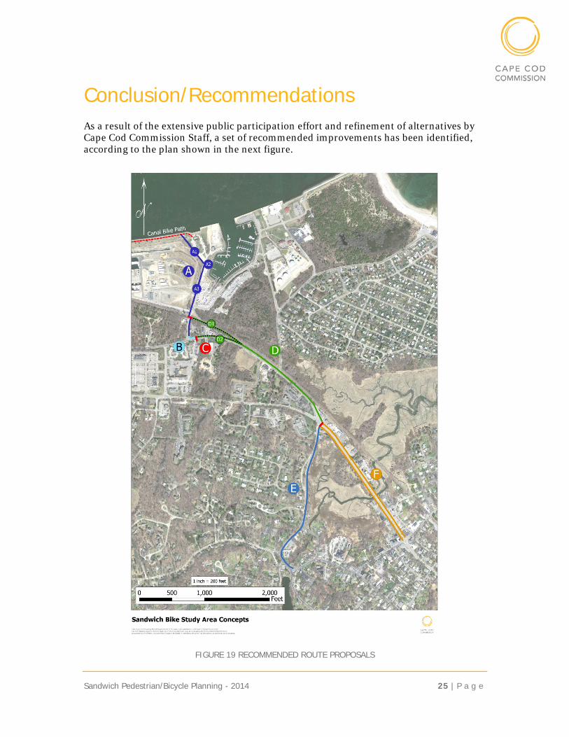
Conclusion/Recommendations As a result of the extensive public participation effort and refinement of alternatives by Cape Cod Commission Staff, a set of recommended improvements has been identified, according to the plan shown in the next figure.
FIGURE 19 RECOMMENDED ROUTE PROPOSALS
P a g e | 26 Sandwich Pedestrian/Bicycle Planning - 2014
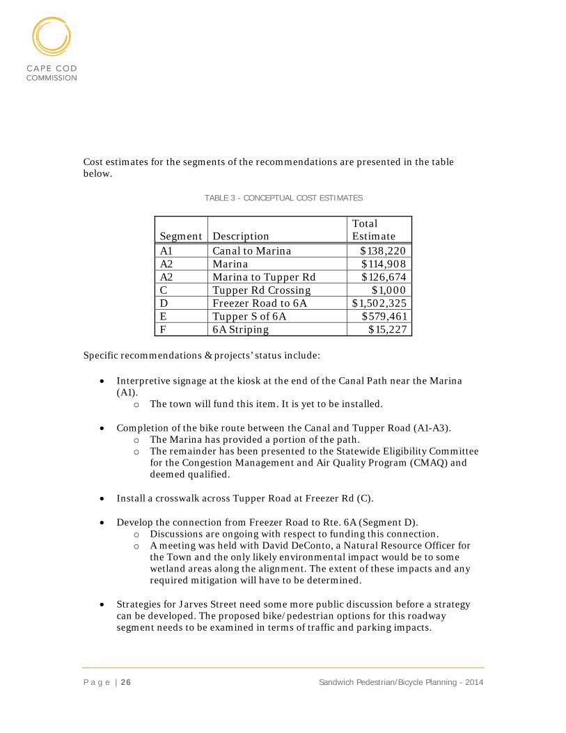
Cost estimates for the segments of the recommendations are presented in the table below.
TABLE 3 - CONCEPTUAL COST ESTIMATES
Segment Description Total Estimate
A1 Canal to Marina $138,220 A2 Marina $114,908 A2 Marina to Tupper Rd $126,674 C Tupper Rd Crossing $1,000 D Freezer Road to 6A $1,502,325 E Tupper S of 6A $579,461 F 6A Striping $15,227
Specific recommendations & projects’ status include:
Interpretive signage at the kiosk at the end of the Canal Path near the Marina (A1).
o The town will fund this item. It is yet to be installed.
Completion of the bike route between the Canal and Tupper Road (A1-A3). o The Marina has provided a portion of the path. o The remainder has been presented to the Statewide Eligibility Committee
for the Congestion Management and Air Quality Program (CMAQ) and deemed qualified.
Install a crosswalk across Tupper Road at Freezer Rd (C).
Develop the connection from Freezer Road to Rte. 6A (Segment D).
o Discussions are ongoing with respect to funding this connection. o A meeting was held with David DeConto, a Natural Resource Officer for
the Town and the only likely environmental impact would be to some wetland areas along the alignment. The extent of these impacts and any required mitigation will have to be determined.
Strategies for Jarves Street need some more public discussion before a strategy
can be developed. The proposed bike/pedestrian options for this roadway segment needs to be examined in terms of traffic and parking impacts.
Sandwich Pedestrian/Bicycle Planning - 2014
CONCLUSION
The Upper Cape’s Cape Cod Canal paths in Bourne and Sandwich are an essential part of the biking gateway to the rest of Cape Cod. The recommendations of this plan advance the goal of making the Cape biking friendly by extending bicycle accommodations through Sandwich Village and eventually to the majority of the Cape’s towns.
While not specifically examined in this study, there a numerous reports that have identified significant economic benefits of providing bicycling infrastructure. For Cape Cod especially, the climate supports biking activity for most months of the year – thus extending the peak season to include the spring and fall and occasional moderate days during winter months.