salinas river national wildlife refuge wildland … · salinas river national wildlife refuge...
TRANSCRIPT
SALINAS RIVER NATIONAL WILDLIFE REFUGE
WILDLAND FIRE MANAGEMENT PLAN
2002
I-1
DECEMBER 2002
WILDLAND FIRE MANAGEMENT PLAN
SALINAS RIVER NATIONAL WILDLIFE REFUGE Prepared: ____________________________________ _____________
Robert Parris, PhD Date Acting Fire Management Officer San Luis NWR Complex ____________________________________ _____________ Margaret Kolar Date Project Leader San Francisco Bay NWR Complex
Concurred: ____________________________________ ____________
Pam Ensley Date Regional Fire Management Coordinator Pacific Region, US Fish and Wildlife Service
Approved: ____________________________________ ____________ Steve Thompson Date Acting Manager
California/ Nevada Operation Manager Pacific Region, US Fish and Wildlife Service
I-2


TABLE OF CONTENTS
EXECUTIVE SUMMARY ........................................................................................................................I-1 INTRODUCTION ......................................................................................................................................I-3 COMPLIANCE WITH USFWS POLICY .................................................................................................I-4 FIRE MANAGEMENT OBJECTIVES......................................................................................................I-6 DESCRIPTION OF REFUGE....................................................................................................................I-6
Cultural Resources .........................................................................................................................I-6 Fish and Wildlife ...........................................................................................................................I-6 Vegetation....................................................................................................................................I-10 Structures and Facilities...............................................................................................................I-12
WILDLAND FIRE MANAGEMENT SITUATION ...............................................................................I-13
Historic Role of Fire ....................................................................................................................I-13 Pre-settlement Fires ........................................................................................................I-13 Post-settlement Fire History ...........................................................................................I-13 Prescribed Fire History ...................................................................................................I-13
Responsibilities ............................................................................................................................I-13 Agency Administrator/ Project Leader (PL)...................................................................I-13 Deputy Project Leader (DPL) .........................................................................................I-14 Refuge Manager (RM).......................................................................................................... Biologist..........................................................................................................................I-14 Zone Fire Management Officer (FMO) ..........................................................................I-14 Prescribed Fire Specialist (PFS) .....................................................................................I-15 Fire Management/Suppression Personnel ......................................................................I-15 Incident Commander.......................................................................................................I-16 Initial Attack Teams........................................................................................................I-16
Interagency Operations ................................................................................................................I-16 Protection of Sensitive Resources................................................................................................I-17
WILDLAND FIRE ACTIVITIES ............................................................................................................I-20
Fire Management Strategies ........................................................................................................I-20 Preparedness ................................................................................................................................I-21
Historical Weather Analysis ...........................................................................................I-21 Fire Prevention................................................................................................................I-22 Staffing Priority Levels...................................................................................................I-22 Training...........................................................................................................................I-22 Supplies and Equipment .................................................................................................I-23
Detection......................................................................................................................................I-23 Communications ..........................................................................................................................I-23 Pre-Attack Plan ............................................................................................................................I-23 Fire Management Units................................................................................................................I-24
Vegetation Type..............................................................................................................I-24
I-1
Fuel Types.......................................................................................................................I-24 Suppression Tactics .....................................................................................................................I-24
Suppression Conditions ..................................................................................................I-25 Wildland Fire Situation Analysis....................................................................................I-25 Aircraft Operations .........................................................................................................I-25
Rehabilitation and Restoration.....................................................................................................I-25 Required Reporting......................................................................................................................I-26 Fire Investigation .........................................................................................................................I-26
PRESCRIBED FIRE ACTIVITIES..........................................................................................................I-27
Prescribed Burn Program Objectives...........................................................................................I-27 Fire Management Strategies ........................................................................................................I-27 Prescribed Fire Planning ..............................................................................................................I-28
Annual Activities ............................................................................................................I-28 Prescribed Burn Plan ......................................................................................................I-28 Strategies and Personnel .................................................................................................I-29 Monitoring and Evaluation .............................................................................................I-30 Required Reports ............................................................................................................I-31 Prescribed Burn Critique ................................................................................................I-31
AIR QUALITY / SMOKE MANAGEMENT GUIDELINES .................................................................I-32 FIRE RESEARCH ...................................................................................................................................I-32 PUBLIC SAFETY ....................................................................................................................................I-33 PUBLIC INFORMATION AND EDUCATION .....................................................................................I-34 FIRE CRITIQUES AND ANNUAL PLAN REVIEW.............................................................................I-35
Fire Critiques ...............................................................................................................................I-35 Annual Fire Summary Report ......................................................................................................I-35 Annual Fire Management Plan Review .......................................................................................I-35
CONSULTATION AND COORDINATION ..........................................................................................I-36 Appendices................................................................................................................................................I-37
Appendix A: References Cited ...................................................................................................I-37 Appendix B: Definitions .............................................................................................................I-38 Appendix C: Special Status Species on the Refuge....................................................................I-41 Appendix D: Fire Dispatch Plan/ Contact List ...........................................................................I-45 Appendix E: Delegation of Authority.........................................................................................I-47 Appendix F: Notification List for Prescribed Burning ...............................................................I-49 Appendix G: Cultural Resource Compliance..............................................................................I-50 Appendix H: Sample WFSA.......................................................................................................I-51 Appendix I: Sample Burn Plan ...................................................................................................I-57
LIST OF FIGURES
I-2

Figure 1: Vegetation ...................................................................................................................................I-7 Figure 2: Heavy equipment use areas .......................................................................................................I-18
I-3
EXECUTIVE SUMMARY When approved, this document will become the Salinas River National Wildlife Refuge fire management plan. Major components include: B updated policy for prescribed fires at Salinas River National Wildlife Refuge, B reference to and inclusion within the Refuge’s 2001 Comprehensive Conservation Plan, B format changes under the direction of Fire Management Handbook (Release Date 6/1/00), and B establishes a Prescribed Fire Program for management of sensitive habitat and reduction of hazardous fuels. This plan is written to provide guidelines for appropriate suppression and prescribed fire programs at Salinas River National Wildlife Refuge. Prescribed fires may be used to reduce hazard fuels, restore the natural processes and vitality of ecosystems, improve wildlife habitat, remove or reduce non-native species, and/or conduct ecological research.
I-4
INTRODUCTION Salinas River National Wildlife Refuge (Refuge) is a valuable natural resource supporting a diversity of habitats and a great variety of aquatic and terrestrial biological resources. The Refuge provides important habitat to many endangered and threatened species as well as species that are candidates for federal listing. Historically, many factors have contributed to the decline of endangered, threatened and rare species present in the Refuge, including historic loss of habitat, human disturbance, exotic vegetation encroachment, and increased predation. The history of fire at the Refuge including fire regimes is not documented or well known. The primary purpose for which the 367-acre Refuge was established in 1973 was for its "particular value in carrying out the national migratory bird management program." It was acquired by the Service through a transfer of surplus military land from the U.S. Army and U.S. Coast Guard. From 1974 through 1991, the area was operated as a Wildlife Management Area under a cooperative agreement with the California Department of Fish and Game. By the mid-1980’s, the growing importance of the Refuge to sensitive species prompted the need for more active management and protection of its resources. In 1991, the Fish and Wildlife Service began managing the area as a National Wildlife Refuge under the National Wildlife Refuge System Administration Act and the Refuge Recreation Act of 1962. Management emphasis is on threatened and endangered species and sensitive migratory birds. The Fire Management Plan (FMP) for the Refuge is written as an operational guide for managing the Refuge's wildland fire and prescribed fire programs. It defines levels of protection needed to ensure safety, protect facilities and resources, and restore and perpetuate natural processes, given the current understanding of the complex relationships in natural ecosystems. It is written to comply with a service-wide requirement that refuges with burnable vegetation develop a fire management plan (620 DM 1). The FMP will be used to help achieve resource objectives of managing unplanned fire and using prescribed fire to control non-native vegetation and restore native upland grassland habitat. The Department of the Interior policy requires that all refuges with vegetation that can sustain fire must have a Fire Management Plan that details fire management policies, the use of prescribed fire for attaining resource management objectives, and fire program operational procedures. This plan is evaluated under NEPA in chapter five of the Draft Comprehensive Conservation Plan/Environmental Assessment. The FMP outlines procedures for wildland suppression and prescribed fires. The fire plan furthers the mission of the Refuge by providing increased protection for Refuge resources and by establishing the framework for a prescribed fire program designed to enhance and maintain native grassland habitat on the Refuge. Increasing coordination and preparedness will help ensure quick response for suppression of fires which have the potential to be devastating to Refuge resources. There is no dedicated fire staff at Salinas River NWR or San Francisco Bay NWRC. All wildland fires will be suppressed by local cooperating agencies with the oversight of the Project Leader and Zone Fire Management Officer (FMO). All prescribed fires will be coordinated through the Zone FMO.
I-5
COMPLIANCE WITH USFWS POLICY The Refuge was established in 1973 by authority of 16 U.S.C. subsection 667b (An Act Authorizing the Transfer of Certain Real Property for Wildlife, or other purposes, 16 U.S.C. subsection 667b-667d, as amended) for wildlife conservation purposes and, in particular, for “carrying out the national migratory bird management program.” Values to be considered in the FMP include: protection of Refuge property and historical sites, protection of neighboring private properties, protection of endangered/threatened/and rare species, and enhancement and protection of Refuge habitats. There are currently 40 special status species known or believed to use habitat at the Refuge (Appendix C). Endangered species include the Smith’s blue butterfly (Euphilotes enoptes smithi), California brown pelican (Pelecanus occidentalis), and the Monterey gilia (Gilia tenuiflora ssp. arenaria); threatened species include the Western snowy plover (Charadrius alexandrinus nivosus) and Monterey spineflower (Chorizanthe pungens var. pungens). This Fire Management Plan has been completed in conjunction with the Refuge’s 2001 Comprehensive Conservation Plan (CCP). The following goals for Salinas River NWR were developed by Refuge staff and are outlined in the CCP. These goals further define the purpose and direction of the Refuge.
$ Protect, restore, and enhance populations of migratory birds and other native species and their habitats.
$ Protect and enhance populations of endangered, threatened, and rare species, and promote their recovery by restoring and enhancing their natural habitats.
$ Provide opportunities for safe, unique, wildlife-dependent recreation when compatible with other Refuge goals.
Several operational plans are used by the Refuge to meet these objectives. These include the CCP, recovery plan for the endangered Smith’s blue butterfly, recovery plan for coastal plants which includes the Monterey spineflower and Monterey (sand) gilia, predator management plan, hunt plan, and internal Section 7 endangered species consultations. The FMP is a detailed program of action to implement fire management policies and objectives, and addresses policy on prescribed burning to control non-native vegetation and restore native grassland habitat. The FMP meets the objectives of the Refuge’s operational plans by supporting strategies which rely upon fire as a management tool and by identifying where and when fire should be applied. The Department Manual, DM 910 (USDI 1997) states the following regarding wildland fires:
“Wildfires may result in loss of life, have detrimental impacts upon natural resources, and damage to or destruction of man-made developments. However, the use of fire under carefully defined conditions is to be a valuable tool in wildland management. Therefore, all wildfires within the Department will be classified either as wildfire or as prescribed fires.
Wildfires, whether on lands administered by the Department or adjacent thereto, which threaten life, man-made structures, or are determined to be a threat to the natural resources or the facilities under the Department's jurisdiction, will be considered emergencies and their suppression given priority over normal Departmental programs.
Bureaus will give the highest priority to preventing the disaster fire - the situation in which a wildfire causes damage of such magnitude as to impact management objectives and/or socio-
I-6
economic conditions of an area. However, no wildfire situation, with the possible exception of threat to human survival, requires the exposure of firefighters to life threatening situations. Within the framework of management objective and plans, overall wildfire damage will be held to the minimum possible giving full consideration to (1) an aggressive fire prevention program; (2) the least expenditure of public funds for effective suppression; (3) the methods of suppression least damaging to resources and the environment; and (4) the integration of cooperative suppression actions by agencies of the Department among themselves or with other qualified suppression organizations.
Prescribed fires...may be used to achieve agency land or resource management objectives as defined in the fire management plans....Prescribed fires will be conducted only when the following conditions are met:
a. Conducted by qualified personnel under written prescriptions. b. Monitored to assure they remain within prescription.
Prescribed fires that exceed the limits of an approved prescribed fire plan will be reclassified as a wildfire. Once classified a wildfire, the fire will be suppressed and will not be returned to prescribed fire status.”
The authority for funding (normal fire year programming) and all emergency fire accounts is found in the following authorities:
Section 102 of the General Provisions of the Department of Interior's annual Appropriations Bill provides the authority under which appropriated monies can be expended or transferred to fund expenditures arising from the emergency prevention and suppression of wildland fire.
P.L. 101-121, Department of the Interior and Related Agencies Appropriation Act of 1990, established the funding mechanism for normal year expenditures of funds for fire management purposes.
31 US Code 665(E)(1)(B) provides the authority to exceed appropriations due to wildland fire management activities involving the safety of human life and protection of property.
Authorities for procurement and administrative activities necessary to support wildland fire suppression missions are contained in the Interagency Fire Business Management Handbook. The Reciprocal Fire Protection Act of May 27, 1955 (42 USC 815a; 69Stat 66) provides Authorities to enter into agreements with other Federal bureaus and agencies; with state, county, and municipal governments; and with private companies, groups, corporations, and individuals regarding fire activities. Authority for interagency agreements is found in AInteragency Agreement between the Bureau of Land Management, Bureau of Indian Affairs, National Park Service, US Fish and Wildlife Service of the United States Department of the Interior and the Forest Service of the United States Department of Agriculture@ (1996).
I-7
FIRE MANAGEMENT OBJECTIVES General Fire Management Objectives for this Refuge are:
1. Protect life and resources/property. 2. Use prescribed fire as a tool to accomplish Refuge habitat management objectives.
Specific Refuge Fire Management Objectives include:
1. Safely suppress all wildland fires using strategies and tactics appropriate to safety considerations and values at risk. 2. Minimize the impact and cost of fire suppression actions. 3. Prevent human-caused wildland fires. 4. Educate the public regarding the role of fire within the Refuge. 5. Use prescribed fire to reduce abundance and limit the spread of non-native plant species and enhance habitats for other species.
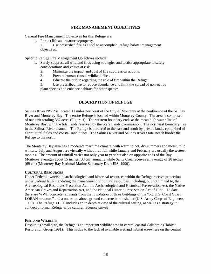
DESCRIPTION OF REFUGE Salinas River NWR is located 11 miles northeast of the City of Monterey at the confluence of the Salinas River and Monterey Bay. The entire Refuge is located within Monterey County. The area is composed of one unit totaling 367 acres (Figure 1). The western boundary ends at the mean high water line of Monterey Bay, with the tidal lands reserved by the State Lands Commission. The northeast boundary lies in the Salinas River channel. The Refuge is bordered to the east and south by private lands, comprised of agricultural fields and coastal sand dunes. The Salinas River and Salinas River State Beach border the Refuge to the north. The Monterey Bay area has a moderate maritime climate, with warm to hot, dry summers and moist, mild winters. July and August are virtually without rainfall while January and February are usually the wettest months. The amount of rainfall varies not only year to year but also on opposite ends of the Bay. Monterey averages about 15 inches (38 cm) annually while Santa Cruz receives an average of 28 inches (69 cm) (Monterey Bay National Marine Sanctuary Draft EIS, 1990). CULTURAL RESOURCES Under Federal ownership, archaeological and historical resources within the Refuge receive protection under Federal laws mandating the management of cultural resources, including, but not limited to, the Archaeological Resources Protection Act; the Archaeological and Historical Preservation Act; the Native American Graves and Repatriation Act, and the National Historic Preservation Act of 1966. To date, there are WWII concrete remnants from the foundation of three buildings of the “old U.S. Coast Guard LORAN structure” and a one room above ground concrete bomb shelter (U.S. Army Corps of Engineers, 1999). The Refuge’s CCP includes an in depth review of the cultural setting, as well as a strategy to conduct a formal Refuge-wide cultural resource survey. FISH AND WILDLIFE Despite its small size, the Refuge is an important wildlife area in central coastal California (Habitat Restoration Group 1991). This is due to the lack of available wetland habitat elsewhere on the central
I-8
Figure 1: Vegetation
I-9

coast as well as the unique wildlife, diversity of habitats, and many significant biological resources the Refuge supports. The diverse habitats within the Refuge include: ocean beach, saline pond, riparian, sand dunes (includes foredunes and coastal scrub dunes), salt marsh, grassland, coastal river lagoon, and formerly farmed upland. Wildlife of dune and beach habitats are able to live under harsh conditions. They survive with little or no fresh water, limited cover and forage. Three federally listed species are reported to occur in these areas of the Refuge: Smith’s blue butterfly, western snowy plover, and California brown pelican. Other special-status species found in this habitat include globuse dune beetle (Coelus globosus), black legless lizard (Anniella pulcha nigra), American white pelican (Pelecanus erythrorhynchos), merlin (Falco columbarius), peregrine falcon, long-billed curlew (Numenius americanus), California gull (Larus californicus), elegant tern (Sterna elegans), and Caspian tern (Sterna elegans) (Appendix C). There are also a variety of non-status species present including: western fence lizard (Sceloporus occidentalis), gopher snake (Pituophis melanoleucus), deer mouse (Peromyscus maniculatis), gray fox (Urocyon cinereoargenteus), red fox (Vulpes fulva), and longtail weasel (Mustela frenata). The Salinas River Lagoon contains both fresh and salt water aquatic species. Native freshwater fish include: Sacramento blackfish (Orthodon microlepidotus), Sacramento sucker (Catostomus occidentalis), Sacramento squawfish (Ptychocheilus grandis), California roach (Lavinia exilicauda), threespine stickleback (Gasterosteus aculeatus) and the federally threatened steelhead/rainbow trout (Oncorhynchus mykiss). Introduced freshwater fish include: carp (Cyprinus carpo), white bass (Morone chrysops), bluegill (Lepomis macrochirus), green sunfish (Lepomis cyanellus), mosquitofish (Gambosia affinis), and threadfin shad (Dorosoma petenense). Saltwater fish found year round at the Refuge include: starry flounder (Platichthyes stellatus) and staghorn sculpin (Leptocottus armatus). Some of the saltwater fish that can be found in the Lagoon include: Pacific herring (Clupia harengus), topsmelt (Atherinops affinis), northern anchovy (Engralis mordax), and at least 5 species of surfperch. (Refer to Chapter 4, Salinas River NWR CCP for a more complete list of species). The upland areas contain grassland, coyote brush scrub, and previously farmed habitats and are used by a variety of wildlife. Reptiles present in these habitats include the western skink (Eumeces skiltonianus), racer (Coluber constrictor), gopher snake, common king snake (Lampropeltis getulus), and western terrestrial garter snake (Thamnophis elegans). Typical upland mammals include gray and red fox, longtail weasel, western harvest mouse (Reithrodontomys megalotis), black-tailed jackrabbit (Lepus californicus), deer mouse, and California ground squirrel (Spermophylis beecheyi). Songbirds and raptors forage in this habitat. Special status species include: white-tailed kite (Elanus leucurus), northern harrier (Circus cyanus), Cooper’s hawk (Accipiter cooperii), merlin, short-eared owl (Asio flammeus), Monterey ornate shrew (Sorex ornatus salarius), and Salinas harvest mouse (Reithrodontomys megalotis: Appendix C). Wetland habitat found at the Refuge provide shelter, forage, and cover for a wide variety of herpetofauna, birds, crustaceans, insects, and mammals, including many special status species. The Refuge’s federally listed species include the western snowy plover and the California brown pelican. Other special status species include: California brackish water snail (Tryonia imitator), Southwestern pond turtle (Clemmys marmorata pallida), steelhead, American white pelican, double-breasted cormorant (Phalacrocorax auritus), bufflehead (Bucephala albeola), osprey, white-tailed kite, northern harrier, sharp-shinned hawk (Accipiter striatus), Cooper’s hawk, merlin, long-billed curlew, California gull, elegant tern, Caspian tern, Forster’s tern (Sterna forsteri), short-eared owl, willow flycatcher (Empidonax traillii), California yellow warbler (Dendroica petechia brewsteri), salt marsh wandering shrew (Sorex vagrans halicoetes), Monterey ornate shrew, and Salinas harvest mouse (Appendix C). Some non-status herpetofauna include the western fence lizard, common garter snake (Thamnophis sirtalis), sharp-tailed snake (Contia tenuis),
I-10
California slender salamander (Batrachoseps attenuatus), and western toad (Bufo boreas). Some mammals include muskrat (Ondatra zibethica), red and gray fox, Virginia opossum (Didelphis virginiana), vagrant shrew (Sorex vagrans), and coyote (Refer to Salinas River CCP for a more complete list of species). The many bird species present are listed below. This unique diversity of habitats supports an enormous variety of wildlife, including many species of migratory birds. The Refuge provides breeding, wintering, foraging, and roosting habitat for shorebirds, waterfowl, raptors, neotropical migrants, terns, gulls, and seabirds. Shorebirds occur at the Refuge year round. The ocean beach and exposed mud flats found along the pond, river and island edges, provide excellent feeding and roosting habitat. Numbers peak during the spring and fall migration periods when thousands of shorebirds use the Refuge. Large wintering populations consist of a variety of species including western snowy plover , western sandpipers (Calidris mauri), American avocets (Recurvirostra americana), black-necked stilts (Himantopus mexicanus), dunlin (C. alpina), other small sandpipers (Calidris sp.), sanderlings (C. alba), dowitchers (Limnodromus sp.), and phalaropes (Phalaropus sp.). Three species of shorebirds are known to nest on the Refuge. They include the Federally threatened western snowy plover, American avocet, and black-necked stilt. All three species have been documented nesting on Refuge islands occurring in the Salinas River. They also nest on saline flats that form as the saline pond evaporates throughout the summer. In addition, snowy plover nests within the foredune habitat. The Refuge has been one of the most productive snowy plover breeding areas in central coastal California (SFNWRC 1998) and traditionally has supported a significant proportion of the remaining breeding population in Monterey Bay. Breeding plovers were once abundant on beaches in San Diego, Los Angeles, Orange, Ventura, and Santa Barbara Counties; however, loss of habitat and increased human disturbance have eliminated the birds from some or all of these areas. This loss of breeding habitat (and plovers) in southern California has made remaining breeding areas, particularly the Monterey Bay area, crucial to maintaining a stable plover population. Since the mid-1980's, increased human disturbance and predation by non-native red fox (Vulpes fulva) have greatly reduced the nesting success of plovers in the Monterey Bay area and at the Refuge (SFNWRC 1998). Major threats to the snowy plover include human disturbance, loss of habitat, exotic vegetation encroachment, and increased predation (SFNWRC 1998). Presently, exotic vegetation control and predator management (avian and mammalian) are being conducted at the Refuge and at other lands throughout the Monterey Bay area to alleviate some of the pressures affecting snowy plovers. A variety of waterbirds use the Refuge for foraging, roosting, and bathing. It provides one of the last freshwater roost sites in central California for as many as 1,400 endangered California brown pelicans. This freshwater roost is especially significant as it may aid the pelicans in ridding their pouches of saltwater lice (SFNWRC 1998). Also, the roost site allows the pelicans to successfully winter, building resources in preparation for the breeding season. Loss of the Moss Landing roost site, due to prolonged disturbance from restoration activities, has likely increased the importance of this Refuge roost site. One of the objectives of the California brown pelican Recovery Plan (USFWS 1983) is to ensure the long-term protection of important roosting locations. Historically, the Federally endangered California least tern (Sterna antillarum browni) and Caspian tern nested at the Refuge. Caspian terns nested on the Refuge in 1996 after a failed attempt at Moss Landing Ecological and Estuarine Research Reserve. This breeding attempt on the Refuge was unsuccessful. Some of the eggs were abandoned while others were incubated to hatching. Indications are that the hatched chicks had been predated by avian predators. Prior to this
I-11
attempt in 1996, the last nesting attempt by Caspian terns occurred in 1986 but that attempt also failed, probably due to human disturbance (SFNWRC 1998). In 1992, five California least terns were seen on the Refuge and may have been nesting in the vicinity. The Refuge also provides roosting and foraging habitat for elegant terns, Forster's terns (S. Forsteri), double-crested cormorants, ring-billed gulls (Larus delawarensis), California gulls (L. californicus), Bonaparte's gulls (L. philadelphia), western gulls (L. occidentalis), great blue herons (Ardea herodias), green-backed herons (Butorides striatus), black-crowned night-herons (Nycticorax nycticorax), snowy egrets (Egretta thula), and great egrets (Casmerodius albus). The Refuge provides important wintering and breeding habitat for waterfowl in the Monterey Bay area. Wintering waterfowl populations vary from 500 to 3,000 on the Refuge depending on water availability. Primary species include ruddy duck (Oxyura jamaicensis), mallard (Anas platyrhynchos), green-winged teal (A. crecca), American wigeon (A. americana), northern shoveler (A. clypeata), cinnamon teal (A. cyanoptera), gadwall (A. strepera), northern pintail (A. acuta), scaup (Aythya sp.), bufflehead, common goldeneye (B. clangula), scoters (Melanitta sp.), and canvasback (A. valisineria). Wintering waterfowl use the Salinas River as well as the saline pond. This 15-acre pond and associated salt marsh is unique as there is no other pond of this type in central coastal California. It receives heavy use by dabbling ducks during spring migration, with as many as 500 ducks foraging and roosting there. Mallards, cinnamon teal, and gadwall have been documented nesting at the Refuge in recent years. These species nest throughout the Refuge in upland and wetland habitats. In addition, American coots (Fulica americana) are seasonally abundant, with as many as 600 present during winter months. Coots also nest at the Refuge in emergent wetland vegetation along the Salinas River. Numerous species of raptors are supported by the Refuge. Northern harriers (Circus cyaneus), American kestrels (Falco sparverius), white-tailed kites (Elanus leucurus), and short-eared owls (Asio flammeus) have been known to nest on the Refuge. Peregrine falcons , barn owls (Tyto alba), red-tailed hawks (Buteo jamaicensis), golden eagles (Aquila chrysaetos), ospreys (Pandion haliaetus), and merlins have also been observed on the Refuge. VEGETATION The biological environment of the Salinas River and surrounding areas (including the Refuge) has been altered drastically from pristine conditions. Historical accounts describe the area as supporting shallow lakes, sloughs, vernal pools, marsh vegetation, expanses of grassland, and riparian corridors. The Salinas River was a part of an enormous wetland ecosystem that included Elkhorn Slough and the Pajaro River. This wetland ecosystem was highly productive as wildlife habitat, especially as wintering habitat for a magnificent number and diversity of waterbird. This area also supported California grizzly bear (Ursus californicus) and tule elk (Cervus elaphus nannodes). Since the time of early European settlement in California, extensive areas have been converted for agricultural purposes. By the early 1900's, much of the land within the lower Salinas Valley had been converted to agricultural production. For example, a series of large finger lakes and associated wetlands had been drained, vernal pools were converted, riparian habitat was removed, and the Salinas and Pajaro rivers were channelized and associated wetlands drained. The mouth of the Salinas River was redirected to its present location. The highly productive Salinas Valley wetland ecosystem that included the Salinas River, Elkhorn Slough and the Pajaro River had been fragmented and greatly reduced in size. As a result of agricultural conversion, the area's wildlife has been severely impacted (SFNWRC1998). The extensive conversion of wetlands resulted in a significant reduction of birds (particularly waterbirds and neotropical migrants), the elimination of tule elk from the region and the probable loss of many vernal pool species. Over 90 percent of the Salinas Valley wetlands have been lost to agricultural
I-12
conversion (SFNWRC 1998). A portion of the Refuge once contained an artichoke field. It has now returned to shrub and grassland habitat, through restoration efforts. As such, the Refuge provides important habitat as it is one of just a few places where remnant wetland and riparian habitats remain from the original Salinas Valley wetland ecosystem. This area was spared from being totally converted for agricultural purposes due to its close proximity to the ocean, susceptibility to flooding, and its former military ownership. There is also a fragile sand dune system on the Refuge that supports a number of sensitive plant species. These dunes include foredunes and coastal scrub dunes. The foredunes are just above the high tide line and have stabilized to some degree, while the dune scrub just beyond the foredunes are more established. Plant species diversity in the foredunes is low. Species commonly found in the foredunes include yellow and pink sand verbena (Abronia latifolia and A. umbellata), silky beach pea (Lathyrus litoralis), beach primrose (Casmissonia cheiranthifolia), sea rocket (Cakile maritima), beach morning glory (Calystegia sordanella), and beach bur (Franseria chamissonis ssp. bipinnatisecta and F. c. ssp. chamissonis) (Appendix C). Dune scrub occurs in the more stabilized areas. The most common species include beach bur, mock heather (Ericameria ericoides ssp. ericoides), branching phacelia (Phacelia ramisissima), blue beach lupine (Lupinus chamisonis), coast buckwheat (Eriogonum latifolium), and dune buckwheat (Eriogonum parvifolium). While neither species of buckwheat is rare or endangered they are hosts to the endangered Smith's blue butterfly. This habitat also supports federally listed plants, Monterey gilia (endangered) and Monterey spineflower (threatened), as well as, sensitive species like the coast wallflower (Erysimum ammophilum), Monterey paintbrush, (Castlleja latifolia var. latifolia), and branching beach aster (Corethrogne leucophlla: Appendix C). Central coast riparian scrub occurs along the Salinas River and on islands within the River. Dominant plant species include willows such as arroyo willow (Salix lasiolepis), red willow (S. laevigata), sandbar willow (S. hindsiana), and yellow willow (S. lasiandra). Understory is typically dense and consists of young trees and shrubs, such as coyote brush (Baccharis pilularis), poison oak (Toxicodendron diversilobum), Himalayan blackberry (Rubus ursinus), and California rose (Rosa californica). The Watershed Institute of California State University have been conducting intensive restoration activities in this habitat to reestablish native riparian scrub vegetation and to slow bank erosion. Species planted include willows, box elder (Acer negundo), creekside dogwood (Cornus serica ssp. occidentalis), red alder (Alnus rubra), and black cottonwood (Populus trichocarpa). Coyote brush scrub represents a successional community that has developed following the abandonment of agriculture fields that were in operation prior to Service occuaption. The dominant species is coyote brush (Baccharis pilularis), which forms dense stands in some places. Grassland, with native and nonnative species, is interspersed throughout this habitat. The Watershed Institute has recently restored a large portion of the grassland to native grasses. In 1996, they drill-seeded 80 lbs. of a native grass mix composed of wild rye (Elymus glaucus), California barley (Hordeum brachyantherum), annual hair grass (Deschamsia caespitosa), and California brome (Bromus carinatus). These native grasses have been maintained by intensive weed pulling, weed wacking, and mowing. STRUCTURES AND FACILITIES The only structure on the Refuge is a World War II era concrete bunker near the parking lot. Because the structure is made entirely of concrete, it is of little concern in a fire situation. No buildings exist offsite in the vicinity of the Refuge. A wooden fence is located on the eastern boundary along the artichoke field. A disced line is maintained on the Refuge adjacent to the fence.
I-13
Most of the Refuge is closed to the public due to the sensitivity of the habitat. However, there are two trails, the River Trail and the Ocean Beach Trail, open to the public (Figure 1). These trails enable visitors to see a variety of habitats and the wildlife that inhabit them. The River Trail begins at the parking lot, runs north through upland habitat and leads to the south bank of the Salinas River. It continues northwest along the south bank of the River for approximately 1/4 mile where it loops back to the southwest through upland habitat to the Beach Trail. This trail is open for walking, hiking, wildlife observation, and wildlife photography. It is also used by hunters to gain access to the hunt area. The Ocean Beach Trail begins in the parking lot, winds through upland habitat, skirts the saline pond, and cuts through the coastal dunes to end at the ocean beach. This trail is open for hiking, wildlife observation, wildlife photography, and access to the ocean and ocean beach. The upper beach habitat, except on the designated trail, is closed along the foredune boundary to protect the western snowy plover. In addition, the saline pond, salt marsh, and coastal dunes are closed to visitor use due to the extreme sensitivity of these habitats. Since parts of the Refuge are open to the public, public use may be impacted for a short duration during fire activities. During prescribed fire activities, certain parts of the Refuge (i.e., trails and area to be burned) would be closed to the public to ensure their safety. Wildland fire suppression and the use of prescribed fire could affect neighboring landowners by altering adjacent habitats and/or potentially escaping onto their properties. However, the escape risk is minimal due to the nature of the adjoining properties. Dune areas along the northern and southern boundaries are sparsely vegetated and would not carry fire under most circumstances. Prescribed fires will be conducted in the grassland habitats of the Refuge. This area is separated from the eastern property by a 15' disced line. In addition, the artichoke plants on the adjacent property are succulent and would not burn. Within the Refuge itself, the judicious, conservative use of prescribed fire will greatly increase the efficiency and effectiveness of grassland/upland management.
I-14
WILDLAND FIRE MANAGEMENT SITUATION HISTORIC ROLE OF FIRE Pre-settlement Fires Historical information on natural or anthropogenic fire is not readily available. Fire history does not generally apply directly to wetlands or riparian areas due to the nature of the wetlands. Post-settlement Fire History There is no record of wildland fires to date. When contacted, the MCFD said they had not responded to a call at the Refuge in the past 10 years (I. Larkin, pers. comm.). The period of high fire danger is from June 1 through October 31, determined by CDF Monterey-San Benito County Unit. Damage from any small fires that might occur include the potential effects on resident or nesting wildlife depending on the time of year. Generally, damaged areas return to their original condition after one or two years. Prescribed Fire History The prescribed fire season at the Refuge is from May to June (I. Loredo, pers. comm). Fires during this period allow non-native weeds to sprout but prevent them from going to seed. Two small prescribed fires were conducted in the Refuge when the property was managed by CA Department of Fish and Game (B. Elliott, pers. comm.). To date, prescribed fire management has not been used on the Refuge by USFWS personnel. RESPONSIBILITIES Salinas River NWR does not have on-site fire management staff or any on-site fire suppression equipment. There is a Service fire crew stationed part-time (late spring to early fall) at San Luis NWRC and a limited number of fire qualified personnel stationed at San Francisco Bay NWRC. Both of these sites are approximately 100 miles from the Refuge. Because the unit is an un-staffed satellite Refuge, Refuge personnel presence is limited to periodic surveys. Wildland fires in this area are generally reported by the public and suppressed by firefighters from the Monterey Bay Fire Department before Service staff can respond.
I-15

Responsibilities for fire management at Salinas River are shared by: the Salinas River Refuge Manager, Refuge Biologist, SFBNWR Complex Project Leader, and the SLNWR Complex Fire Management
I-16

I-17
Χ provide overall management of the Refuge including the fire program, Χ ensure collateral duty fire personnel are meeting Service standards, Χ conduct prescribed fire activities in support of Refuge habitat management programs, $ establish and maintain appropriate fire-related agreements/contracts, $ monitor results of wildland and prescribed fires, $ update fire management and associated plans (dispatch, training, etc.), call-out lists, and
mobilization guidelines, and $ maintain the Refuge fire cache and fire equipment in a ready state. Agency Administrator/ Project Leader (PL) Χ Is the primary line officer responsible for implementation of all Fire Management
activities within the Complex and will ensure compliance with Department, Service and Refuge policies.
Χ Selects the appropriate management responses to wildland fire. Deputy Project Leader (DPL) Χ Coordinates Complex programs to ensure personnel and equipment are made available
and used for fire management activities including fire suppression, prescribed burning and fire effects monitoring.
Χ Ensures that the fire management program has access to Refuge and Complex resources when needed.
Χ Ensures that Refuge Managers and Complex Staff consider the fire management program during Refuge related planning and implementation.
Refuge Manager (RM) Χ Identifies prescribed burn units and biological objectives to Fire Management Officer
(FMO) and Prescribed Fire Specialist (PFS), notifies FMO of prescribed fire project constraints, and ensures that Refuge resources are available to accomplish prescribed fire and fire suppression objectives.
Χ Acts as the primary Refuge Resource Management Specialist during fire management planning and operations.
Χ Prepares an annual report detailing fire occurrences and prescribed fire activities undertaken in each calendar year. This report will serve as a post-year's fire management activities review, as well as provide documentation for development of a comprehensive fire history record for the Refuge.
Χ Is responsible for planning, coordinating, and directing preparedness activities including fire training, physical fitness testing and Interagency Fire Qualification System (IFQS) data entry, fire cache and equipment inventory accountability, maintenance, and operation, cooperation with cooperative agencies.
Biologist Χ Coordinates through Refuge Managers and Deputy Project Leader to provide biological
input for the fire program with the FMO and PFS. Χ Ensures fire effects monitoring is being implemented and drafts wildland fire
Rehabilitation Plans for Deputy Project Leader. Χ Assists in design and implementation of fire effects monitoring, with FMO and PFS. Χ Participates, as requested, in prescribed burning and wildland fire suppression.
I-18
Zone Fire Management Officer (FMO) Χ Responsible for all fire related planning and implementation for the Refuge. Χ Integrates biological Refuge objectives into all fire management planning and
implementation. Χ Solicits program input from the RM and Biologist. Χ Supervises prescribed fire planning. Χ Coordinates fire related training. Χ Coordinates with cooperators to ensure adequate resources are available for fire
operational needs. Χ Decides when to request overhead or additional firefighting personnel and equipment. Χ Is responsible for implementation of this Plan. This responsibility includes coordination
and supervision of all prevention, pre-suppression, detection, wildland fire, prescribed fire, suppression, monitoring, and post-fire activities involving Refuge lands.
Χ Is responsible for preparation of fire reports following the suppression of wildfires and for operations undertaken while conducting prescribed fires.
Χ Submits budget requests and monitors FIREBASE funds. Χ Maintains records for all personnel involved in suppression and prescribed fire activities,
detailing the individual's qualifications and certifications for such activities. Χ Updates all fire qualifications for entry into the Fire Management Information System. Χ Nominates personnel to receive fire-related training, as appropriate. Χ Designates the person to serve as Incident Commander (IC) for initial attack purposes.
The FMO may assume the position of IC at his/her discretion or designate other personnel to take over that position at his/her discretion.
Prescribed Fire Specialist (PFS) Χ Responsible for the planning and implementation of a program, which collects
information for the documentation, analysis, and prediction of fire behavior and effects. Χ Develops and recommends, plans, and schedules management ignited fire activities for
the Refuge. Χ Implements and directs burns. Χ Plans and develops a program to collect information on the effects and behavior of
prescribed fire. Χ Plans and directs studies to monitor and analyze fire behavior parameters, then uses these
data to support the development of fire plans. Χ Plans and directs surveys for the collection, analysis and documentation of data relating
to fire effects on biotic and abiotic resources. Χ Organizes and performs studies to develop fire management prescriptions for prescribed
burns. Χ Is responsible for ensuring a cadre of qualified prescribed fire overhead by
recommending personnel for training, through both formal in-house and field training assignments.
Χ Is responsible for record keeping associated with burn planning, fire occurrence reporting and fire weather.
Χ Identifies areas of fire management requiring research and works with research scientists in the development of project statements to accomplish this research.
Fire Management/Suppression Personnel
I-19
Χ Consist of all Refuge personnel, whether permanent or seasonal, who meet the minimum standard set by the National Wildfire Coordinating Group (NWCG) for firefighters.
Χ Are fully equipped with proper personal protective equipment, have taken and passed the minimum classroom training, and meet physical fitness standards required.
Χ Undertake fire management duties as assigned by the Prescribed Fire Burn Boss on each prescribed fire project.
Χ Are responsible for their personal protective equipment and physical conditioning, qualifying annually with the work capacity test before May 31.
Incident Commander Incident Commanders (of any level) use strategies and tactics as directed by the Refuge Manager and WFSA where applicable to implement selected objectives on a particular incident. A specific Limited Delegation of Authority (Appendix E) will be provided to each Incident Commander prior to assuming responsibility for an incident. Major duties of the Incident Commander are given in NWCG Fireline Handbook, including: Χ Brief subordinates, direct their actions and provide work tools. Χ Ensure that safety standards identified in the Fire Orders, the Watch Out Situations, and
agency policies are followed at all times. Χ Personally scout and communicate with others to be knowledgeable of fire conditions,
fire weather, tactical progress, safety concerns and hazards, condition of personnel, and needs for additional resources.
Χ Order resources to implement the management objectives for the fire. Χ Inform appropriate dispatch of current situation and expected needs. Χ Coordinate mobilization and demobilization with dispatch and the Collateral FMO. Χ Perform administrative duties; i.e., approving work hours, completing fire reports for
command period, maintaining property accountability, providing or obtaining medical treatment, and evaluating performance of subordinates.
Χ Assure aviation safety is maintained to the highest standards. Initial Attack Teams Initial attack teams will consist of fully-qualified firefighters and leaders. Teams will be prepared and equipped with hand and power tools as needed and will be dispatched with a day's supply of food and water, so they can continue work for 24 hours without additional support. Employees participating in any wildland fire activities on Fish and Wildlife Service or cooperator=s lands will meet fitness requirements established in PMS 310-1, except where Service-specific fitness requirements apply. Exceptions to fitness requirements on Initial attack activity are available from the Regional Fire Management Coordinator per guidelines in Chapter 1.5 of the Fire Management Handbook (USFWS 2000a). INTERAGENCY OPERATIONS There are no formal cooperative fire agreements in place at this time, however a Memorandum of Understanding is currently being established between the Refuge and the Monterey County Fire Department (MCFD). The MCFD has traditionally responded to wildland fires at the Refuge because of their legal fire protection responsibility to the property surrounding the Refuge. Thus, any wildland fire originating on Refuge lands is considered a threat to their property.
I-20
Salinas River NWR will use the Incident Command System (ICS) as a guide for fireline organization. Qualifications for individuals is per DOI Wildland Fire Qualifications and Certification System, part of NIIMS and the National Wildland Fire Coordination Group (NWCG) Prescribed Fire Qualification Guide. Depending on fire complexity, some positions may be filled by the same person. The County of Monterey Fire Department has the responsibility for preventing, controlling, and extinguishing fire throughout unincorporated portions of the County. The County responds to fires near the Refuge border because of their protection responsibilities for County property. Any fire starting on Refuge lands would be suppressed by County resources because of their interest in preventing fires from spreading onto their Local Responsibility Area. While no formal agreement is currently in place, the County has expressed a willingness to respond to emergency suppression activities (Appendix F). Monterey Bay Unified Air Pollution Control District (MBUAPCD) is responsible for all non-point and point source air degradation within their designated area of responsibility. Burn permits and smoke management concerns from prescribed burning on the Refuge must be coordinated through them. Like all air polluction control districts, MBUAPCD has regulatory authority and enforces all District, state and federal laws relating to the emissions of air pollutants (Appendix F). A listing of key interagency contacts can be found in the Fire Dispatch Plan. The plan is an annual assembly of information required to facilitate a rapid response to a fire report and to coordinate the initial attack. (Appendix D). There are no formal fire related agreements in place at this time. All agreements at this time are informal. PROTECTION OF SENSITIVE RESOURCES Aggressive attack of all unplanned ignitions with minimum acreage burned is the suppression goal. Heavy equipment shall not be used due to the sensitivity of the habitat, except in cases where life or fire-fighter safety is threatened or when the Refuge Manager determines necessary. Dozer lines should only be constructed, when necessary, in Coyote Scrub/Grassland Habitat, preferably along highlighted established trail lines, but also allowed within the shaded area on map (Figure 2). The Regional Archaeologist and/or his/her staff will work with fire staff, project leaders, and incident commanders to ensure that cultural resources are protected from fire and fire management activities. The “Request For Cultural Resource Compliance” form (Appendix G) will be used to inform the Regional Archaeologist of impending activities, thereby meeting the regulations and directions governing the protection of cultural resources as outlined in Departmental Manual Part 519, National Historic Preservation Act (NHPA) of 1966, Code of Federal Regulations (36CFR800), the Archaeological Resources Protection Act of 1979, as amended, and the Archaeological and Historic Preservation Act of 1974. The NHPA Section 106 clearance will be followed for any fire management activity that may affect historic properties (cultural resources eligible to the National Register of Historic Places). Impacts to archaeological resources by fire and suppression resources vary. The four basic sources of damage are (1) fire intensity, (2) duration of heat, (3) heat penetration into soil, and (4) suppression actions. Of the four, the most significant threat is from equipment during line construction for prescribed fires or wildfire holding actions.
I-21
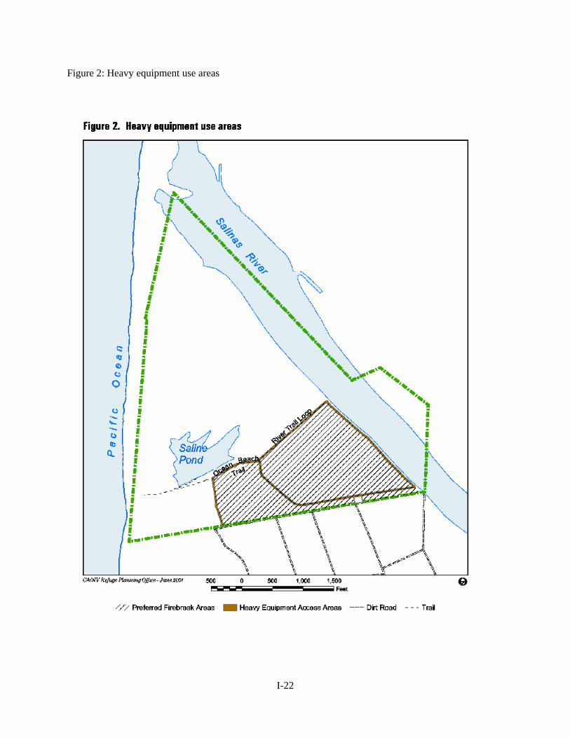
Figure 2: Heavy equipment use areas
I-22
The following actions will be taken to protect archaeological and cultural resources: Wildland Fires Χ Minimum impact fire suppression tactics will be used to the fullest extent possible. Χ Resource Advisors will inform Fire Suppression personnel of any areas with cultural resources. Χ The Resource Advisor should contact the Regional Archaeologist and /or his/her staff for more
detailed information. Χ Foam use will be minimized in areas known to harbor surface artifacts. Χ Mechanized equipment should not be used in areas of known cultural significance. Χ The location of any sites discovered as the result of fire management activities will be reported to
the Regional Archaeologist using the RCRC. Prescribed Fires Χ The Refuge Fire staff will submit a completed RCRC to the Regional Archaeologist and/or
his/her staff as soon as the burn area is identified (i.e., as soon as feasible). Χ Upon receipt of the RCRC, the Regional Archaeologist and/or his/her staff will be responsible for
consulting with the FMO and evaluating the potential for adverse impacts to cultural resources. Χ When necessary, the Regional Archaeologist and/or his/her staff will coordinate with the State
Historic Preservation Officer (SHPO). The SHPO has 30 days to respond. The Refuge will consider all SHPO recommendations.
Χ Mechanized equipment should not be used in areas of known cultural significance. Χ The location of any sites discovered as the result of fire management activities will be reported to
the Regional Archaeologist .
I-23
WILDLAND FIRE ACTIVITIES Fire program management describes the operational procedures necessary to implement fire management at Salinas River NWR. Program management includes: fire prevention, preparedness, emergency preparedness, fire detection, communication, step-up staffing plan, pre-attack plan, fire behavior predictions, fire suppression, minimum impact suppression, minimum impact rehabilitation, documentation, and fire investigation. All fires not classified as prescribed fires are wildland fires and will be appropriately suppressed. Suppression operations will generally be conducted by the Monterey County Fire Department (MCFD). Records show that fire season is typically from June 1 to October 31. Depending on the specific weather of any particular year, the seasons may be shorter or longer and, therefore, may start earlier or last longer. FIRE MANAGEMENT STRATEGIES All unplanned wildland fires will be suppressed in a prompt, safe, aggressive, and cost-effective manner to produce fast, efficient action with minimum damage to resources using appropriate management strategies. Wildland fires will not be used as a resource management tool. The following strategies will be employed to meet fire management objectives:
$ Suppress all unplanned ignitions in a safe and cost-effective manner consistent with resources and values at risk. Minimum impact strategies and tactics will be used when possible, particularly in areas with high densities of endangered species. However, use of heavy equipment remains an option for control of high intensity fires and fires threatening critical values such as endangered species and private lands. Χ Maintain formal and informal cooperative relationships with local fire agencies to provide immediate response to wildfires. Χ Conduct all fire-management programs in a manner consistent with applicable laws, policies and regulations. Χ Initiate cost-effective fire monitoring which will ascertain if objectives are being met. Monitoring information will also be used to refine burn prescriptions to better achieve objectives. Χ Use prescribed fire as a management tool for achieving hazard fuel reductions and resource management objectives. To the extent possible, hazard fuel prescribed fire will be used to accomplish specific objectives established for individual land units. Prescribed fires are fires which are deliberately set to burn under prescribed conditions in order to achieve pre-determined resource management objectives. Χ Integrate fire ecology and management themes into future information programs.
Although resource impacts of suppression alternatives must always be considered in selecting a fire management strategy, resource benefits will not be the primary consideration. Appropriate suppression action will be taken to ensure firefighter safety, public safety, and protection of the resources. Critical protection areas, such as dune and marsh habitat, will receive priority consideration in fire control planning efforts. In all cases, the primary concern of fire suppression personnel shall be safety, and if needed, all individuals not involved in the suppression effort may be evacuated. Suppression strategies should be applied so that the equipment and tools used to meet the desired objectives are those that inflict the least impacts upon the natural and cultural resources. Minimum
I-24
impact suppression strategies will be employed to protect all resources. Natural and artificial barriers will be used as much as possible for containment. When necessary, fire line construction will be conducted in such a way as to minimize long-term impacts to resources. Vehicle access to normally closed areas of the Refuge, except dune and beach habitat, will be made using existing roads when possible. When off-road travel is determined to be necessary, vehicle access will be allowed in designated areas of the Refuge with approval of the Project Leader or Delegate (Figure 2). Heavy equipment such as crawlers, tractors, dozers, or graders will not be used within the Refuge boundaries unless their use is necessary to prevent a fire from destroying privately-owned and/or government buildings and historic resources. Heavy equipment will only be used in designated areas (Figure 2). The use of any heavy equipment requires approval from the Refuge Manager or Delegate. Sites impacted by fire suppression activities or by the fire will be rehabilitated as necessary, based on an approved course of action for each incident. PREPAREDNESS Preparedness is the work accomplished prior to fire occurrence to ensure that the appropriate response, as directed by the Fire Management Plan, can be carried out. Preparedness activities include: budget planning, equipment acquisition, equipment maintenance, dispatch (i.e. initial attack, extended, and expanded), equipment inventory, personnel qualifications, and training. The preparedness objective is to have a well trained and equipped fire management organization to manage all fire situations within the Refuge. Preparedness efforts are to be accomplished in the time frames outside the normal fire season dates. The Fish and Wildlife Service has minimum training requirements for all fire positions. The Service is a member to the National Wildfire Coordinating Group (NWCG) and accepts its standards for interagency operations. There is a required refresher training for all personnel that are involved with wildland fire activities. These requirements are found in the USFWS Fire Management Preparedness and Planning Handbook, Section 1.5; Training, Qualification, and Certification (USFWS 2000b). The traditional approach to a step-up plan does not work in this situation. Due to the availability of a large number of local fire department resources, it would be a rare situation if Service fire crews were deployed to the Refuge during a step-up situation. Historical weather analysis The fire season generally begins with the curing of annual grasses in early June and extends until the first rains in late-October. In general, fire does not apply directly to wetlands or riparian habitats due to the hydrology. Salinas River NWR does not operate a weather station and does not monitor the weather at the Refuge. Monterey County Fire Department does not have any weather data that reflects the conditions at the Refuge. The closest weather information can be obtained from a hotline provided by the Monterey Peninsula Airport but mentions no specifics for the weather conditions at the Refuge. Fire Prevention An active fire prevention program may be conducted in conjunction with other agencies to protect human life and property, and prevent damage to cultural resources or physical facilities.
I-25
Firelines are disked by adjacent farm personnel along the eastern one-third of the southern boundary of the Refuge. The Salinas River forms the northeast boundary of the Refuge, and the Pacific Ocean forms the western boundary. The southern boundary abuts agricultural fields of artichokes and other garden-type produce. A program of internal and external education regarding potential fire danger may be implemented. Visitor contacts, bulletin board materials, and interpretive programs may be used to increase visitor and neighbor awareness of fire hazards. Employees need to relate to the public the beneficial effects of prescribed fires as opposed to unwanted human-caused fires, with emphasis on information, essential to understanding the potential severity of human-caused wildland fires and how to prevent them. During periods of extreme or prolonged fire danger (Red Flag Warnings), emergency restrictions regarding Refuge operations may become necessary. No heavy machinery, ATV’s, lawnmowers, etc. will be permitted in the coyote brush scrub/grassland at these times. Such restrictions, when imposed, will usually be consistent with those implemented by cooperators. The Refuge Manager or FMO will recommend when such restrictions are necessary. Staffing Priority Levels There are no fire-funded staff stationed at the Refuge. Fire suppression response is provided by MCFD, therefore MCFD will adjust staffing levels based on current fire danger. Because the Refuge headquarters is located 100 miles from the Refuge, MCFD will be first responders. The Refuge has no facilities located within the boundaries and will not require any closures (except to machinery previously mentioned) during Red Flag Warnings. Training Departmental policy requires that all personnel engaged in suppression and prescribed fire duties meet the standards set by the National Wildfire Coordinating Group (NWCG). Salinas River NWR will conform strictly to the requirements of the wildland fire management qualification and certification system and USFWS guidelines. Basic wildland fire training refreshers are offered annually for red-carded firefighters and records kept in a centralized database. Additional training is available from surrounding agencies in pump and engine operation, power saws, firefighter safety, fire weather and fire behavior, helicopter safety and prescribed fire objectives and activities. On-the job training is encouraged and will be conducted at the field level. Whenever appropriate, the use of fire qualification task books will be used to document fire experience of trainees. The FMO will coordinate fire training needs with those of other nearby refuges, cooperating agencies, and the RO. The Refuge supports the development of individual Incident Command System (ICS) overhead personnel from among qualified and experienced Refuge staff for assignment to overhead teams at the local, regional, and national level. Fire suppression is an arduous duty. On prescribed fires, personnel may be required to shift from implementation/monitoring activities to suppression. Poor physical condition of crew members can endanger safety and lives during critical situations. Therefore, personnel performing fire management duties will maintain a high level of physical fitness. This requires successful completion of a fitness pack test. Personnel must complete a three mile hike with a 45 pound pack in less than 45 minutes. Supplies and Equipment A small, 10-person cache for the Refuge is located at the Complex headquarters in Fremont, two hours from the Refuge. The cache is maintained by the Complex staff and is accessible 24 hours a day. The
I-26
cache consists of personal protective equipment (e.g. clothing and boots) and fire tools (e.g. shovel and rake). Additional equipment and supplies are available through cooperators and the interagency cache system. Requests for additional personnel and equipment are made through the Mendocino NF Dispatch. The contact list can be found in the Dispatch plan (Appendix D). Annual fire readiness requires an inventory of existing cache items. The cache should be capable of outfitting six personnel for wildfire activities and will be inventoried as ready by June 1 of each year. DETECTION Most wildland fires are reported by the public to the emergency telephone number 9-1-1. The 9-1-1 dispatchers contact MCFD for suppression response. The Refuge is contacted by MCFD with a report of all wildland fire activities. The Fire Management Plan does not discriminate between human-caused and lightning caused fire. All wildland fires will be suppressed. Any human-caused fires of suspicious origin (as determined by the Refuge Manager or FMO) will require an investigation and report by law enforcement personnel. For serious human-caused fires, including those involving loss of life, a qualified arson investigator will be requested. COMMUNICATIONS There is no open radio communication frequency for Refuge personnel. Instead, staff use a direct connect cellular phone system. Prescribed fire activities performed by Service personnel use the various NIFC Tactical channels as needed. Normally NIFC Tactical channels 2 (168.200 mhz) and 3 (168.600 mhz) are used depending upon the number of frequencies needed during prescribed burns. There is currently no common communication link between Service personnel and MCFD. PRE-ATTACK PLAN Maps showing locations of water sources, roads, sensitive plant communities, private property, etc will be kept at Refuge headquarters and distributed to Cooperators to facilitate actions that effectively suppress fires while protecting values at risk. The Refuge will use Del Monte Boulevard as the primary firebreak and other arterial crossroads as holding line (Figure 2). FIRE MANAGEMENT UNITS The Refuge will be managed as one unit. Although there are four vegetation communities, the overall objective is to restore and maintain the area with native vegetation. Consistent with Service policy, all fires will be managed as either wildland fires or prescribed fires. Suppression strategies, management restrictions, fuels, fire environment and values at risk are similar throughout the Refuge. Thus all lands will be managed as one single fire management unit. Due to staff limitations, relatively small land management parcels, long response times, valuable resources, and values at risk on neighboring lands, this plan does not recommend wildland fire managed for resource benefit as an option for the unit. Wildland fires will be suppressed using the appropriate suppression response. Prescribed fires will be used to reduce hazardous fuels and to meet resource management objectives.
I-27
Vegetation Type The majority of the vegetation on the Refuge is marsh or grass species which have high rate of fire spread when dry. Small expanses of riparian habitat with grass in the understory have high rates of fire spread in strong winds. The proposed prescribed fire burn area is within coyote scrub brush/ grassland habitat (Figure 1). There have been no observed federally listed plant species within this habitat. There are native plants that include wild rye, California barley, annual hair grass, and California brome, which were planted by the Watershed Institute for restoration. Currently, intensive hand weeding, weed wacking, and mowing are used to maintain native grassland. Late spring fires, in May and June, will benefit native grasses by reducing nonnative weed seed banks, which have later seed production. Fuel Types and Fire Behavior Fuel types at the Refuge are predominately upland grass, seasonal marsh, and riparian woodland-dominated fuel types, Fire Behavior Fuel Models (FBFM)1, 3, and 9. Fuel Model 1 and 3 encompasses approximately 195 acres of the Refuge and have high rates of spread. FBFM 1 has a rate of spread of 275 chains/hr (3.5 mph) and a flame length of 7.7 ft. FBFM has a rate of spread of 259 chains/hr (3.0mph) and a flame length of 20.4 ft. Fuel Model 9 encompasses approximately 20 acres and has a rate of spread of 22 chains/hr and a flame length of 4.8 ft. This small portion of riparian habitat with grass understory would exhibit smoldering and creeping rates due to the mosaic site characteristics unless strong winds are present. Fire behavior in these model types can be simulated with the model BEHAVE. SUPPRESSION TACTICS Wildland fires will be suppressed in a prompt, safe, aggressive, and cost-effective manner to produce fast, efficient action with minimum damage to resources. Suppression involves a range of possible actions from initial attack to final suppression. All wildland fires will be suppressed. Personnel and equipment must be efficiently organized to suppress fire effectively and safely. To this end, the FMO assumes the command function on major or multiple fire situations, setting priorities for the use of available resources, and establishing a suppression organization. There will be only one Incident Commander responsible through the FMO, Refuge Manager or Delegate. The Incident Commander will designate all overhead positions on fires requiring extended attack. Suppression Conditions The typical fire suppression response to a fire at SRNWR would consist of an IC provided by the MCFD and two engines. Water is the primary method for extinguishing fires. Handline is not usually needed for suppression efforts. Foam and/or retardents have not yet been determined to be compatible with Refuge resources. Aggressive attack of all unplanned ignitions with minimum acreage burned is the goal. Heavy equipment shall not be used due to the sensitivity of the habitat, except in cases where life or fire-fighter safety is threatened or when the Refuge Manager deems it necessary. Safety of personnel and sensitive habitat at risk will determine its use. This decision will be made by the incident commander, in concert with a Refuge Biologist or Manager. Suppression guidelines will be outlined in the MOU with MCFD. Wildland Fire Situation Analysis For fires that cannot be contained in one burning period, a WFSA must be prepared (Appendix H). In the case of a wildland fire, the Incident Commander, in conjunction with the FMO, will prepare the WFSA. Approval of the WFSA resides with the Refuge Project Leader.
I-28
The purpose of the WFSA is to allow for a consideration of alternatives by which a fire may be controlled. Damages from the fire, suppression costs, safety, and the probable character of suppression actions are all important considerations. Public safety will require coordination between all Refuge staff and the IC. Notices should be posted to warn visitors, trails may be closed, traffic control will be necessary where smoke crosses roads, etc. Where wildland fires cross roads, the burned area adjacent to the road should be mopped up and dangerous snags felled. Every attempt will be made to use natural and constructed barriers, including changing fuel complexes, in the control of wildland fire. Rehabilitation efforts will concentrate on the damages done by suppression activities rather than on the burned area itself. Aircraft Operations Aircraft may be used in all phases of fire management operations. All aircraft must be Office of Aircraft Services (OAS) or Forest Service approved. An OAS Aviation Policy Department Manual will be provided by OAS. Helicopters may be used for reconnaissance, bucket drops and transportation of personnel and equipment. Natural helispots and parking lots are readily available in most cases. Clearing for new helispots should be avoided where possible. Improved helispots will be rehabilitated following the fire. As in all fire management activities, safety is a primary consideration. Qualified aviation personnel will be assigned to all flight operations. REHABILITATION AND RESTORATION When suppression action is taken, rehabilitation is appropriate. The most effective rehabilitation measure is prevention of impacts through careful planning and the use of minimum impact suppression techniques. Fire rehabilitation will be as prompt as possible to prevent erosion and spread of non-native plants. This will be developed by the Refuge staff and submitted to the Regional Fire Management Coordinator for review within 90 days of the unplanned ignition being declared out. Rehabilitation will be initiated by the Incident Commander, FMO, or Refuge Manager. Rehabilitation will be directed toward minimizing or eliminating the effects of the suppression effort and reducing the potential hazards caused by the fire. These actions may include:
1. Backfill control lines, scarify, and seed. 2. Install water bars and construct drain dips on control lines to prevent erosion. 3. Install check dams to reduce erosion potential in drainages. 4. Restore natural ground contours. 5. Remove all flagging, equipment and litter. 6. Consider and plan more extensive rehabilitation or revegetation to restore sensitive impacted
areas. If revegetation or seeding is necessary, only native plant species will be used. If emergency rehabilitation measures are needed or if rehabilitation is needed to reduce the effects of a wildland fire then the Refuge can request appropriate funding through the Burned Area Emergency Rehabilitation (BAER) fund.
I-29
Rehabilitation plans for each fire will be reviewed by the Refuge Manager. A final plan will be submitted to Region for establishing an account. Rehabilitation should be initiated prior to complete demobilization or early the following season. REQUIRED REPORTING A DI-1202, fire report, will be filled out and submitted to the Regional Fire Management Officer for input into the Fire Management Information System (FMIS) within 20 days of the fire being declared out. Copies of reports from the Monterey County Fire Department will be obtained and report will be written to summarize the specifics of the fire, actions taken and outcomes from those actions. A formal review will be conducted on all serious injuries and losses of significant resources. FIRE INVESTIGATION Fire management personnel will attempt to locate and protect the probable point of origin and record pertinent information required to determine fire cause. They will be alert for possible evidence, protect the scene and report findings to the fireline supervisor. The Refuge Manager, FMO, or IC may request a fire investigator through the MCFD. Prompt and efficient investigation of all suspicious fires will be carried out. However, fire management personnel should not question suspects or pursue the fire investigation unless they are currently law enforcement commission qualified. Personnel and services of other agencies may be used to investigate wildland fire arson or fire incidents involving structures. All fire investigations should follow the guidelines outlined in 4.1-2 of the Fire Management Handbook (2000a).
PRESCRIBED FIRE ACTIVITIES PRESCRIBED BURN PROGRAM OBJECTIVES Prescribed fire can be a useful tool for restoring and maintaining natural conditions and processes at Salinas River NWR. The goal of prescribed fire at the Refuge is to maintain between 50% and 75% cover of native grassland composed of at least 90% (by plant cover) grasses and herbs native to the local area within 15 years, within the mosaic of grassland and coastal scrub habitat (Objective 2.2 of Salinas River NWR CCP). The objectives of prescribed fire are to:
1. Maintain and enhance native grassland with prescribed fire in addition to mowing and herbicide use. 2. Limit extent of nonnative species [e.g. wild radish (Raphanus sativus), hemlock (Conium maculatum), and mustard (Brassica rapa ssp.olifera)]
Prescribed fires involve the use of fire as a tool to achieve management objectives. Research burning may also be conducted when determined to be necessary for accomplishment of research project objectives. To meet the goals and objectives of prescribed fires on the Refuge, it is important to monitor the grasslands and choose the most appropriate areas and timing to conduct the burns. That is, burns should be conducted in areas that currently support native species, and should be conducted after native grasses have set seed and cured, but before nonnatives have seeded. Follow up is necessary to determine
I-30
frequency of burning and spot treating. Actions included in the prescribed burn program include: the selection and prioritization of prescribed burns to be carried out during the year, prescribed burn plans, burn prescriptions, burn operations, documentation and reporting, and burn critiques. Measures to ensure the successful implementation of the prescribed fire program are to:
1. Conduct a vigorous prescribed fire program with the highest professional and technological standards;
2. Identify the prescribed burn parameters that are most appropriate for meeting resource management objectives;
3. Efficiently accomplish resource management objectives through the application of prescribed fire;
4. Continually evaluate the prescribed fire program to better meet program goals by refining prescriptions treatments and monitoring methods, and by integrating applicable technical and scientific advancements;
5. Prepare prescribed burn plans with a review by a qualified Prescribed Fire Manager/Prescribed Burn Boss, and approval by the Refuge Manager; and
6. Conduct prescribed burns with an adequate number of qualified personnel to conduct the burn as well as to mop-up.
The Refuge reserves the option to use an interagency team approach for complex burns carried out on the boundaries and close to developed areas or burns of large acreage. The most highly qualified and experienced personnel in the regional interagency community would be requested to serve on this team. FIRE MANAGEMENT STRATEGIES Prescribed fire will be used to reduce hazard fuel accumulation, restore fire to fire-dependent ecological communities, improve wildlife habitat, and to maintain cultural/ historic scenes where appropriate. All prescribed fire activity will comply with applicable Federal, state, and local air quality laws and regulations. All prescribed fire projects will have a burn plan approved by the Project Leader. Each burn plan will be prepared using a systematic decision-making process, and contain measurable objectives, predetermined prescriptions, and using an approved environmental compliance document. Appropriate NEPA documentation exists for this Fire Management Plan in the Draft CCP/Environmental Assessment. Therefore, additional NEPA documentation will be necessary only for prescribed fire projects not meeting the criteria outlined in this Plan. Prescribed Fire Burn Plans must include components such as a Go/No/Go Checklist, contingency actions to be taken in the event the prescription is exceeded, and the need for alerting neighbors and appropriate public officials to the timing and the planing of the burn. A burn plan format meeting all required needs is located in Appendix I. Fire monitoring will be used to evaluate the degree to which burn objectives are accomplished. Monitoring can assist managers in documenting success in achieving overall programmatic objectives and limiting occurrence of undesired effects. PRESCRIBED FIRE PLANNING Annual Activities The FMO will be responsible for completing an annual fire summary report. The report will contain the number of fires by type, acres burned by fuel type, cost summary, personnel employed, and fire effects.
I-31
The Refuge Manager, Biologist, and FMO will determine burn unit priorities, timing, and burn plan development schedule by January of each year. Burn Plans will be prepared and submitted for Project Leader review and approval by March. The Burn Plan will be submitted to the Air Quality District by March 30 for smoke management review and authorizing letter. Prescribed Fire activities will be reviewed annually. Necessary updates or changes to the Fire Management Plan will be accomplished prior to the next fire season. Any additions, deletions, or changes will be reviewed by the Refuge Manager to determine if such alterations warrant a re-approval of the plan. Prescribed Burn Plan The Prescribed Burn Boss will conduct a field reconnaissance of the proposed burn location with the FMO, Biologist, and/or Refuge Manager to discuss objectives, special concerns, and gather all necessary information to write the burn plan. After completing the reconnaissance, a qualified Burn Boss will write the prescribed burn plan. All prescribed fires will have prescribed burn plans. The prescribed burn plan is a site specific action plan describing the purpose, objectives, prescription, and operational procedures needed to prepare and safely conduct the burn. The treatment area, objectives, constraints, and alternatives will be clearly outlined. No burn will be ignited unless all prescriptions of the plan are met. Fires not within those parameters will be suppressed. Prescribed Burn Plans will follow the format contained in Appendix I. Each burn plan will be reviewed by the Refuge Manager, Biologist, FMO, and Burn Boss. The Project Leader has the authority to approve the burn plan. The term “burn unit” refers to a specific tract of land to which a prescribed burn plan applies. Strategies and Personnel Execution of prescribed burns will only be executed by qualified personnel. The Prescribed Burn Boss will fill all required positions to conduct the burn with qualified personnel. All personnel listed in the burn plan must be available for the duration of the burn or the burn will not be initiated. Personnel will meet minimum USFWS fitness and qualifications standards for prescribed burning. Weather and fuel moisture conditions must be monitored closely in planned burn units to determine when the prescription criteria are met. A belt weather kit may also be utilized to augment monitoring. Fuel moisture samples of 10-, 100-, and 1000-hour down and dead logs (where applicable) and of live plants may be monitored each week and percent moisture contents figured to help determine when the prescription criteria are met. When all prescription criteria are within the acceptable range, the Prescribed Burn Boss will select an ignition date based on current and predicted weather forecasts. A thorough briefing will be given by the Prescribed Burn Boss and specific assignments and placement of personnel will be discussed. An updated spot weather forecast will be obtained on the day of ignition and all prescription elements will be rechecked to determine if all elements are still within the approved ranges. If all prescription elements are met, a test fire will be ignited to determine on-site fire behavior conditions as affected by current weather. If conditions are not satisfactory, the test fire will be suppressed and the burn will be rescheduled. If conditions are satisfactory the burn will continue as planned. Specific management needs for the Refuge as a whole and for specific areas will be determined annually. Specific burn objectives, fire frequency rotation, firing methodology, and prescriptions will vary from year to year. Burn plans will be updated to reflect any variations. Project Leader will approve prescribed fire plans.
I-32
Based on resource needs, 10 to 40 acres per year will be targeted for burning in coyote brush scrub/grassland habitat only. The burn would occur in May or June, allowing native grasses to drop seed, but prior to nonnatives going to seed. Additional planting of native grasses may be necessary to achieve final objectives. No threatened or endangered species are known to exist in this habitat, but ground nesting birds, such as mallards, have been found in the area. Prescribed burns will initially be used to restore and enhance the native grassland, controlling non-native weeds by burning for several consecutive years. Once non-natives are reduced to a controllable level in an area, fire will then be used for maintenance of the grasslands, requiring only periodic burns. Depending upon the complexity of the burn, two or more fire crews (3 crew members per crew) from the Central Valley Refuges Zone and 3-4 collateral fire duty personnel from SFBNWRC may be needed to ignite, hold, and mop-up the burn. In addition, personnel and equipment from MCFD shall be available in the event that fire spreads outside Refuge property and into their local responsibility area. A qualified Prescribed Burn Boss Type III or higher will be required to write the Burn Plan and serve as Burn Boss during any planned ignitions One person with botanical/sampling design expertise will also be needed to conduct pre and post burn monitoring. One person with biological/botanical expertise will be needed to assist in developing site specific prescribed burn plans. Only qualified personnel will be used to conduct burns on the Refuge. Pre- and post-fire briefings will be conducted on all planned ignitions. Coordination needed with the following entities: Χ Monterey Bay Unified Pollution Control District: Written approval required; Burn Plan
needs to be submitted 30 days in advance of planned ignition; day of fire approval required. Χ Monterey County Police Department: Needs to be contacted the day of the burn to notify
them of potential smoke across roads. Χ Monterey County Fire Department: Needs to receive copy of Prescribed Burn Plan 1 month
in advance. Χ California State Parks, Martin Jefferson & Sons, Robert Scattini, City of Marina, and other
adjacent landowners: Adjacent or nearby landowners need to be contacted at least 1 week prior to the burn so that vehicles are moved and employees are aware of the burn.
Χ Volunteers and personnel from other agencies or organizations that conduct research on the Refuge need to be contacted at least 1 week prior to the burn (Appendix F).
The Refuge will procure burn permits and follow procedures in them. In addition, the Zone Fire Management Officer or an individual qualified at the Prescribed Burn Boss Type III level will write a Burn Plan to be approved by the Project Leader. The guidance and format for writing Burn Plans is found in the Service’s Prescribed Fire Management Handbook, Section 2.2. All ignitions require a DI-1202 form to completed and returned to the responsible fire management officer for input into the Fire Management Information System (FMIS) within 20 days after the fire is declared out. If the prescribed burn escapes the predetermined burn area, all further ignition will be halted except as needed for suppression efforts. Suppression efforts will be initiated, as discussed in the preburn briefing. The FMO will be notified immediately of any control actions on a prescribed burn. If the burn exceeds the initial suppression efforts, the burn will be declared a wildland fire and suppressed using guidelines established in this plan. If a prescribed burn is declared a wildland fire, all personnel must meet NWCG
I-33
qualifications and fitness levels for wildland fire activities. A WFSA will be completed and additional personnel and resources ordered as determined by the Incident Commander. If the fire continues to burn out of control, additional resources will be called from the local cooperating agencies via the servicing dispatch. A management overhead team may be requested to assume command of the fire. Recommendations of the Monterey Bay Unified Pollution Control District will be followed which will satisfy the District's criteria for use of the "72-Hour Outlook/48-Hour Decision" forecasting procedure. These may include restrictions on igniting under certain wind speeds/directions, humidity, or other conditions that would cause local air quality to be degraded. Other conditions under which fires will not be ignited include: east wind conditions, Red Flag Warnings /Watches, situations where local fire department resources are over committed to wildland fires in the Bay Area (i.e., Oakland Hills Fire 1991 or Vision -Pt. Reyes Fire 1995). The prescribed fire plan will also identify other "go-no-go" or suppression criteria. Prior to any planned ignitions, Burn Boss will contact MCFD Emergency Communications Center to determine resource availability in case of an escaped burn. Monitoring and Evaluation Monitoring of prescribed fires is intended to provide information for quantifying and predicting fire behavior and its ecological effects on refuge resources while building a historical record. Monitoring measures the parameters common to all fires: fuels, topography, weather and fire behavior. In addition, ecological changes such as species composition and structural changes will be monitored after a fire. This information will be very useful in fine-tuning the prescribed burn program. All wildland fires will be appropriately suppressed. However, monitoring wildland fires may be appropriate and potentially valuable in mapping and documenting the growth of the fire, measuring on-site weather and fuel loading to provide the fire staff with present and expected fire behavior and effects. During prescribed burns, monitoring can serve as a precursor to invoking suppression action by determining if the fire is in prescription, assessing its overall potential, and determining the effects of the prescribed burn. During prescribed burning, monitoring should include mapping, weather, site and fuel measurements and direct observation of fire characteristics such as flame length, rate of spread and fire intensity. Operational monitoring provides a check to insure that the fire remains in prescription and serves as a basis for evaluation and comparison of management actions in response to measured, changing fire conditions, and changes such as fuel conditions and species composition. All fires may be monitored regardless of size. The FMO will establish specific fire information guidelines for each fire to update intelligence about the fire. Highest priority for monitoring will be assigned to large fires or fires which threaten to leave the Refuge. Short term: BEHAVE predictions will be used to model fire behavior, and a belt weather kit will be used to monitor actual burn day conditions. The Service presently has no fire effects results for the Refuge. Long term: The response of native and non-native vegetation to the prescribed fire will be monitored. Plant species composition and percent cover will be measured pre and post burn for certain native and weed species of concern. Monitoring must be done to document and verify that the stated objectives have been met. Plots, photo points, or other methods will be developed to document the results of the burn. These data will be stored for future refinement of prescriptions and to determine the success of the program.
I-34
Required Reports All prescribed burn forms will be completed as outlined by the Prescribed Burn Boss. A monitor will be assigned to collect all predetermined information and complete all necessary forms prior to, during, and after the burn. All records will be archived in the refuge's fire records for future use and reference. The Prescribed Burn Boss will prepare a final report on the prescribed burn for the Fire Analysis Committee. Information will include a narrative of the burn operation, a determination of whether objectives were met, weather and fire behavior data, map of the burn area, photographs of the burn, number of work hours, and final cost of the burn. Prescribed Burn Critique A report detailing the actual burn will accompany any recommendations or changes deemed necessary in the program. This report will be submitted to the Refuge Project Leader. A post-season critique of the fire management program, including the prescribed burn program, will be held each year at the conclusion of the fall fire season.
I-35
AIR QUALITY / SMOKE MANAGEMENT GUIDELINES Air quality is managed by the Monterey Bay Unified Air Pollution District (MBUAPD). Burn permits must be issued to conduct a prescribed burn. The Refuge would obtain a Prescribed Burn Permit each year prescribed burning is conducted. The Refuge would follow all conditions of the permits. MBUAPD is currently in the process of revising fee structure. There has been no determination, yet direction is forthcoming. The Refuge is located in an area that is classified by EPA and the California State Air Resources Board as "Non-Attainment" for Particulate Matter -10 (PM-10). Close coordination between the Refuge and the MBUAPD is required to meet PM-10 emission requirements if prescribed burning is done . Specific aspects of a Smoke Management Plan (wind, weather, visibility hazard, and residual smoke problems) would be addressed on project Prescribed Burn Plans prepared for each burn, as required per Title 17 of the State Air Resources Board.
FIRE RESEARCH The Refuge would collect data and monitor the success or failure of burning under certain conditions required to accomplish objectives of controlling non-native vegetation and restoring riverine and upland sand dune habitat. Weather conditions would be recorded to establish future successful/ideal burning results. Additional research may be conducted as funds become available.
I-36
PUBLIC SAFETY Salinas River NWR is dedicated to ensuring the safety of each visitor and to all residents and property adjacent to the Refuge's boundary. Therefore, during prescribed burns and wildland fires, the Refuge will be closed to the public. Firefighter and public safety will always take precedence over property and resource protection during any fire management activity. For public safety, the fire scene and areas determined by the Refuge Manager or Project Leader, will remain clear of unauthorized people. The responsibility for managing public safety lies with the Incident Commander (IC) or Burn Boss for wildland or prescribed fire. Public safety considerations will be included as part of the burn prescription. Where possible, areas of fire activity will be signed at visitor centers and bulletin boards. Residents adjacent to the Refuge may be notified of any prescribed burn and if any fire poses a threat to burn onto their lands (Appendix F). During prescribed burns at least one burn team member will have first aid training. A first aid kit will be on-site for prescribed burns as well as wildland fires. The local police, fire, and emergency medical services will be notified prior to the ignition of any prescribed burn. They will also be notified of the location of any wildland fires.
I-37
PUBLIC INFORMATION AND EDUCATION Informing the public is an important part of the fire management program. During a wildfire, the IC is responsible for providing information to the public. Prescribed fire public information would be addressed in the Prescribed Fire Plan and the Environmental Assessment when developed. Educating the public on the value of fire as a natural process is important to increasing public understanding and support for the fire management program. The Refuge will use the most appropriate and effective means to explain the overall fire and smoke management program. This may include signing, personal contacts, interpretive panels, or media releases. When deemed necessary, interpretive presentations will address the fire management program and explain the role of fire in the environment. The public information program will be developed as follows:
1. Concepts of the prescribed burn program will be incorporated, as appropriate, in future interpretive panels, and in local publications.
2. During periods when prescribed burns are ignited, handouts will be prepared, posted, and distributed to all visitors.
3. The fire management program may be incorporated into visitor contacts. Particular attention will be given when fires are conspicuous from roads or visitor use areas.
4. News releases will be distributed to the media as appropriate. 5. The public information outlets of neighboring and cooperating agencies and the regional
office will be provided with all fire management information. 6. The fire management program will be discussed in informal talks with all employees ,
volunteers, residents, and neighbors. Prior to the lighting of any planned ignition, information should be made available to visitors, local residents, and/or the press about what is scheduled to happen and why. On-site information will be provided to alleviate visitor concern about the apparent destruction of resources by fire or the impairment of views due to temporary smoke. This information will include prescribed burn objectives and control techniques, current fire location and behavior, effects caused by the fire, impacts on private and public facilities and services, and restrictions and closures. As outlined in the prevention section, restrictions may become necessary during Red Flag Warnings, but public use should not be affected.
I-38
FIRE CRITIQUES AND ANNUAL PLAN REVIEW FIRE CRITIQUES Fire reviews will be documented and filed with the final fire report. The FMO will retain a copy for the Refuge files. ANNUAL FIRE SUMMARY REPORT The FMO will be responsible for completing an annual fire summary report. The report will contain the number of fires by type, acres burned by fuel type, cost summary (prescribed burns and wildland fires), personnel utilized, and fire effects. ANNUAL FIRE MANAGEMENT PLAN REVIEW The Fire Management Plan will be reviewed annually. Necessary updates or changes will be accomplished prior to the next fire season. Any additions, deletions, or changes will be reviewed by the Refuge Manager to determine if such alterations warrant a re-approval of the plan. The fire management plan will be updated as major policy decisions are made. At a minimum, this plan will be reviewed once a year by the individual on the Refuge with fire responsibility to maintain the integrity of the plan. Amendments to the fire management plan itself will be made as needed by sending them to the Regional Fire Management Coordinator for concurrence and to be approved by the Regional Director in Portland. Minor changes to the appendices, such as phone number corrections and personnel changes, can be made at the Refuge level and attached to the plan during this yearly review process without involvement of the Regional Office.
I-39
CONSULTATION AND COORDINATION The following agencies, organizations and/or individuals were consulted in preparing this plan. Roddy Baumann, Prescribed Fire Specialist, Pacific Region, USFWS, Portland, OR Richard Hadley, Assistant Refuge Supervisor (NV/So. CA), USFWS, Sacramento, CA Rachel Hurt, Wildlife Biologist, San Francisco Bay NWRC, USFWS, Fremont, CA Diane Kodama, Wildlife Biologist, Salinas River NWR, USFWS, Fremont, CA Ivette Loredo, Refuge Manager, Salinas River NWR, USFWS, Fremont, CA Amanda McAdams, Fire Planner, Pacific Region, USFWS, Portland, OR Dave Paullin, Klamath/Central Valley Refuge Supervisor,USFWS, Sacramento, CA Tom Romanello, Assistant Fire Management Officer, Sheldon-Hart NWR, Lakeview, OR.
I-40
APPENDICES APPENDIX A: REFERENCES CITED Habitat Restoration Group, Inc. 1991. Salinas River Lagoon Management and Enhancement Plan. Administrative Draft. Prepared for Salinas River Lagoon Task Force. Monterey Bay National Marine Sanctuary Drafts EIS, 1990. San Francisco National Wildlife Refuge Complex (SFNWRC). 1998. Draft Public Use Management Plan and Environmental Assessment. U. S. Army Corps of Engineers. 1999. Inventory Project Report Castroville Amphibious Training Base. Supplemental. U. S. Fish and Wildlife Service. 1983. California Brown Pelican Recovery Plan. U. S. Fish and Wildlife Service. 2000a. Fire Management Handbook. U. S. Fish and Wildlife Service. 2000b. Fire Management Preparedness and Planning Handbook. Personal Communication: Larkin, Ian, ECC Captain, MCFD, 8 June 2001. Loredo, Ivette, Refuge Manager SRNWR, USFWS, 11 June 2001. Valentine, Nicholas, Archeologist, Museum Specialist, USFWS Region 1, 2000.
I-41
APPENDIX B: DEFINITIONS Agency Administrator. The appropriate level manager having organizational responsibility for management of an administrative unit. May include Director, State Director, District Manager or Field Manager (BLM); Director, Regional Director, Complex Manager or Project Leader (FWS); Director, Regional Director, Park Superintendent, or Unit Manager (NPS), or Director, Office of Trust Responsibility, Area Director, or Superintendent (BIA). Appropriate Management Action. Specific actions taken to implement a management strategy. Appropriate Management Response. Specific actions taken in response to a wildland fire to implement protection and fire use objectives. Appropriate Management Strategy. A plan or direction selected by an agency administrator which guide wildland fire management actions intended to meet protection and fire use objectives. Appropriate Suppression. Selecting and implementing a prudent suppression option to avoid unacceptable impacts and provide for cost-effective action. Bureau. Bureaus, offices or services of the Department. Class of Fire (as to size of wildland fires):Class A - 3 acre or less. Class B - more than 3 but less than 10 acres. Class C - 10 acres to 100 acres. Class D - 100 to 300 acres. Class E - 300 to 1,000 acres. Class F - 1,000 to 5,000 acres. Class G - 5,000 acres or more. Emergency Fire Rehabilitation/Burned Area Emergency Rehabilitation (EFR/BAER). Emergency actions taken during or after wildland fire to stabilize and prevent unacceptable resource degradation or to minimize threats to life or property resulting from the fire. The scope of EFR/BAER projects are unplanned and unpredictable requiring funding on short notice. Energy Release Component (ERC) A number related to the available energy (BTU) per unit area (square foot) within the flaming front at the head of a fire. It is generated by the National Fire Danger Rating System, a computer model of fire weather and its effect on fuels. The ERC incorporates thousand hour dead fuel moistures and live fuel moistures; day to day variations are caused by changes in the moisture content of the various fuel classes. The ERC is derived from predictions of (1) the rate of heat release per unit area during flaming combustion and (2) the duration of flaming. Extended attack. A fire on which initial attack forces are reinforced by additional forces. Fire Suppression Activity Damage. The damage to lands, resources and facilities directly attributable to the fire suppression effort or activities, including: dozer lines, camps and staging areas, facilities (fences, buildings, bridges, etc.), handlines, and roads. Fire effects. Any consequences to the vegetation or the environment resulting from fire, whether neutral, detrimental, or beneficial.
I-42
Fire intensity. The amount of heat produced by a fire. Usually compared by reference to the length of the flames. Fire management. All activities related to the prudent management of people and equipment to prevent or suppress wildland fire and to use fire under prescribed conditions to achieve land and resource management objectives. Fire Management Plan. A strategic plan that defines a program to manage wildland and prescribed fires and documents the Fire Management Program in the approved land use plan. The plan is supplemented by operational procedures such as preparedness plans, preplanned dispatch plans, prescribed fire plans and prevention plans. Fire prescription. A written direction for the use of fire to treat a specific piece of land, including limits and conditions of temperature, humidity, wind direction and speed, fuel moisture, soil moisture, etc., under which a fire will be allowed to burn, generally expressed as acceptable range of the various fire-related indices, and the limit of the area to be burned. Fuels. Materials that are burned in a fire; primarily grass, surface litter, duff, logs, stumps, brush, foliage, and live trees. Fuel loadings. Amount of burnable fuel on a site, usually given as tons/acre. Hazard fuels. Those vegetative fuels which, when ignited, threaten public safety, structures and facilities, cultural resources, natural resources, natural processes, or to permit the spread of wildland fires across administrative boundaries except as authorized by agreement. Initial Attack. An aggressive suppression action consistent with firefighter and public safety and values to be protected. Maintenance burn. A fire set by agency personnel to remove debris; i.e., leaves from drainage ditches or cuttings from tree pruning. Such a fire does not have a resource management objective. Natural fire. A fire of natural origin, caused by lightning or volcanic activity. NFDRS Fuel Model. One of 20 mathematical models used by the National Fire Danger Rating System to predict fire danger. The models were developed by the US Forest Service and are general in nature rather than site specific. NFFL Fuel Model. One of 13 mathematical models used to predict fire behavior within the conditions of their validity. The models were developed by US Forest Service personnel at the Northern Forest Fire Laboratory, Missoula, Montana. Prescription. Measurable criteria which guide selection of appropriate management response and actions. Prescription criteria may include safety, public health, environmental, geographic, administrative, social, or legal considerations. Prescribed Fire. A fire ignited by agency personnel in accord with an approved plan and under prescribed conditions, designed to achieve measurable resource management objectives. Such a fire is designed to produce the intensities and rates of spread needed to achieve one or more planned benefits to natural
I-43
resources as defined in objectives. Its purpose is to employ fire scientifically to realize maximize net benefits at minimum impact and acceptable cost. A written, approved prescribed fire plan must exist and NEPA requirements must be met prior to ignition. NEPA requirements can be met at the land use or fire management planning level. Preparedness. Actions taken seasonally in preparation to suppress wildland fires, consisting of hiring and training personnel, making ready vehicles, equipment, and facilities, acquiring supplies, and updating agreements and contracts. Prevention Activities directed at reducing the number or the intensity of fires that occur, primarily by reducing the risk of human-caused fires. Rehabilitation (1) Actions to limit the adverse effects of suppression on soils, watershed, or other values, or (2) actions to mitigate adverse effects of a wildland fire on the vegetation-soil complex, watershed, and other damages. Suppression. A management action intended to protect identified values from a fire, extinguish a fire, or alter a fire's direction of spread. Unplanned ignition. A natural fire that is permitted to burn under specific conditions, in certain locations, to achieve defined resource objectives. Wildfire. An unwanted wildland fire. Wildland Fire. Any non-structure fire, other than prescribed fire, that occurs in the wildland. Wildland Fire Situation Analysis (WFSA). A decision-making process that evaluates alternative management strategies against selected safety, environmental, social, economical, political, and resource management objectives as selection criteria. Wildland/urban interface fire A wildland fire that threatens or involves structures.
I-44
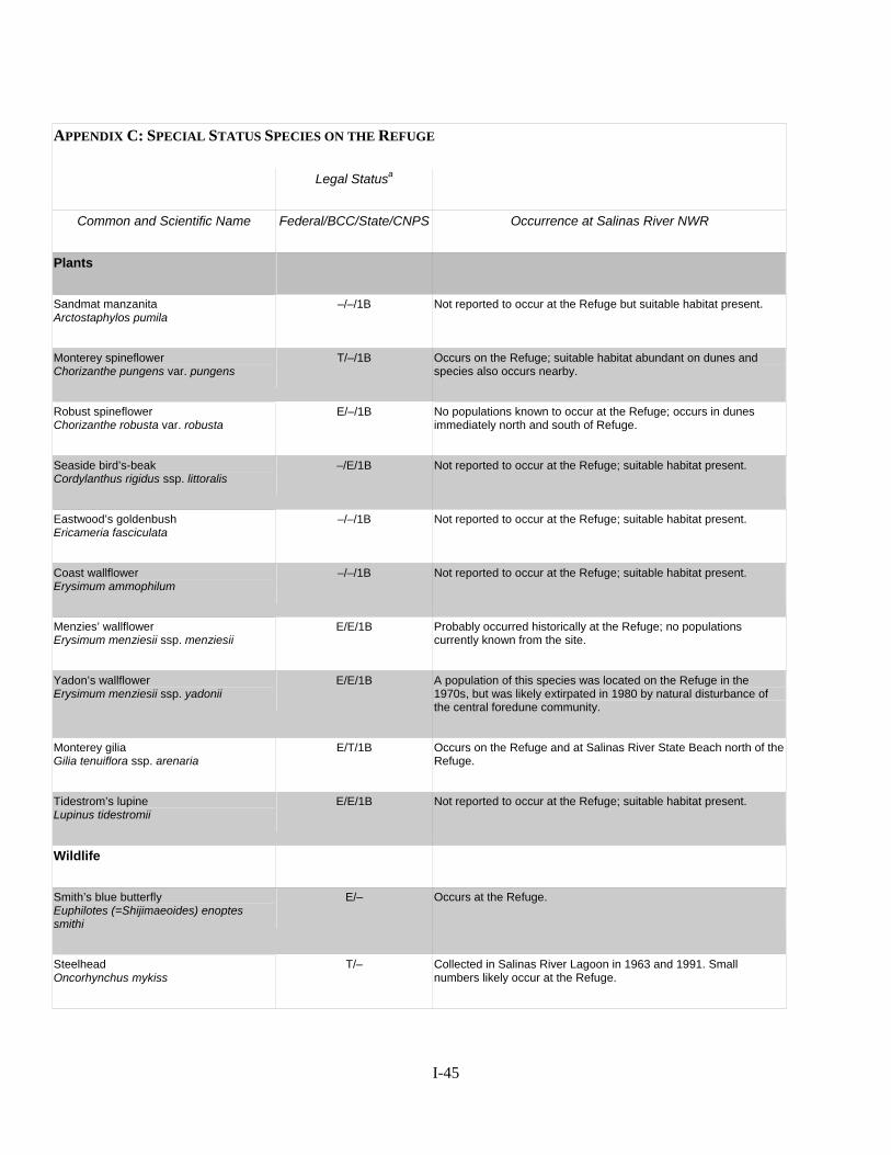
APPENDIX C: SPECIAL STATUS SPECIES ON THE REFUGE
Legal Statusa
Common and Scientific Name Federal/BCC/State/CNPS Occurrence at Salinas River NWR
Plants
Sandmat manzanita Arctostaphylos pumila
–/–/1B Not reported to occur at the Refuge but suitable habitat present.
Monterey spineflower Chorizanthe pungens var. pungens
T/–/1B Occurs on the Refuge; suitable habitat abundant on dunes and species also occurs nearby.
Robust spineflower Chorizanthe robusta var. robusta
E/–/1B No populations known to occur at the Refuge; occurs in dunes immediately north and south of Refuge.
Seaside bird’s-beak Cordylanthus rigidus ssp. littoralis
–/E/1B Not reported to occur at the Refuge; suitable habitat present.
Eastwood’s goldenbush Ericameria fasciculata
–/–/1B Not reported to occur at the Refuge; suitable habitat present.
Coast wallflower Erysimum ammophilum
–/–/1B Not reported to occur at the Refuge; suitable habitat present.
Menzies’ wallflower Erysimum menziesii ssp. menziesii
E/E/1B Probably occurred historically at the Refuge; no populations currently known from the site.
Yadon’s wallflower Erysimum menziesii ssp. yadonii
E/E/1B A population of this species was located on the Refuge in the 1970s, but was likely extirpated in 1980 by natural disturbance of the central foredune community.
Monterey gilia Gilia tenuiflora ssp. arenaria
E/T/1B Occurs on the Refuge and at Salinas River State Beach north of the Refuge.
Tidestrom’s lupine Lupinus tidestromii
E/E/1B Not reported to occur at the Refuge; suitable habitat present.
Wildlife
Smith’s blue butterfly Euphilotes (=Shijimaeoides) enoptes smithi
E/– Occurs at the Refuge.
Steelhead Oncorhynchus mykiss
T/– Collected in Salinas River Lagoon in 1963 and 1991. Small numbers likely occur at the Refuge.
I-45
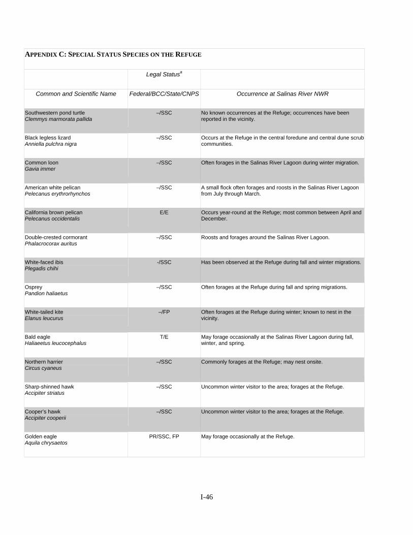
APPENDIX C: SPECIAL STATUS SPECIES ON THE REFUGE
Legal Statusa
Common and Scientific Name Federal/BCC/State/CNPS Occurrence at Salinas River NWR
Southwestern pond turtle Clemmys marmorata pallida
–/SSC No known occurrences at the Refuge; occurrences have been reported in the vicinity.
Black legless lizard Anniella pulchra nigra
–/SSC Occurs at the Refuge in the central foredune and central dune scrub communities.
Common loon Gavia immer
–/SSC Often forages in the Salinas River Lagoon during winter migration.
American white pelican Pelecanus erythrorhynchos
–/SSC A small flock often forages and roosts in the Salinas River Lagoon from July through March.
California brown pelican Pelecanus occidentalis
E/E Occurs year-round at the Refuge; most common between April and December.
Double-crested cormorant Phalacrocorax auritus
–/SSC Roosts and forages around the Salinas River Lagoon.
White-faced ibis Plegadis chihi
-/SSC Has been observed at the Refuge during fall and winter migrations.
Osprey Pandion haliaetus
–/SSC Often forages at the Refuge during fall and spring migrations.
White-tailed kite Elanus leucurus
–/FP Often forages at the Refuge during winter; known to nest in the vicinity.
Bald eagle Haliaeetus leucocephalus
T/E May forage occasionally at the Salinas River Lagoon during fall, winter, and spring.
Northern harrier Circus cyaneus
–/SSC Commonly forages at the Refuge; may nest onsite.
Sharp-shinned hawk Accipiter striatus
–/SSC Uncommon winter visitor to the area; forages at the Refuge.
Cooper’s hawk Accipiter cooperii
–/SSC Uncommon winter visitor to the area; forages at the Refuge.
Golden eagle Aquila chrysaetos
PR/SSC, FP May forage occasionally at the Refuge.
I-46
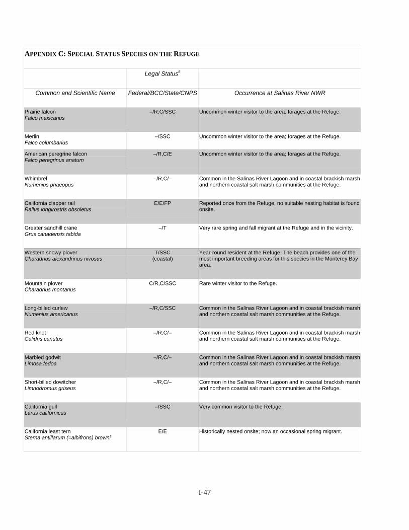
APPENDIX C: SPECIAL STATUS SPECIES ON THE REFUGE
Legal Statusa
Common and Scientific Name Federal/BCC/State/CNPS Occurrence at Salinas River NWR
Prairie falcon Falco mexicanus
–/R,C/SSC Uncommon winter visitor to the area; forages at the Refuge.
Merlin Falco columbarius
–/SSC Uncommon winter visitor to the area; forages at the Refuge.
American peregrine falcon Falco peregrinus anatum
–/R,C/E Uncommon winter visitor to the area; forages at the Refuge.
Whimbrel Numenius phaeopus
–/R,C/– Common in the Salinas River Lagoon and in coastal brackish marsh and northern coastal salt marsh communities at the Refuge.
California clapper rail Rallus longirostris obsoletus
E/E/FP Reported once from the Refuge; no suitable nesting habitat is found onsite.
Greater sandhill crane Grus canadensis tabida
–/T Very rare spring and fall migrant at the Refuge and in the vicinity.
Western snowy plover Charadrius alexandrinus nivosus
T/SSC (coastal)
Year-round resident at the Refuge. The beach provides one of the most important breeding areas for this species in the Monterey Bay area.
Mountain plover Charadrius montanus
C/R,C/SSC Rare winter visitor to the Refuge.
Long-billed curlew Numenius americanus
–/R,C/SSC Common in the Salinas River Lagoon and in coastal brackish marsh and northern coastal salt marsh communities at the Refuge.
Red knot Calidris canutus
–/R,C/– Common in the Salinas River Lagoon and in coastal brackish marsh and northern coastal salt marsh communities at the Refuge.
Marbled godwit Limosa fedoa
–/R,C/– Common in the Salinas River Lagoon and in coastal brackish marsh and northern coastal salt marsh communities at the Refuge.
Short-billed dowitcher Limnodromus griseus
–/R,C/– Common in the Salinas River Lagoon and in coastal brackish marsh and northern coastal salt marsh communities at the Refuge.
California gull Larus californicus
–/SSC Very common visitor to the Refuge.
California least tern Sterna antillarum (=albifrons) browni
E/E Historically nested onsite; now an occasional spring migrant.
I-47
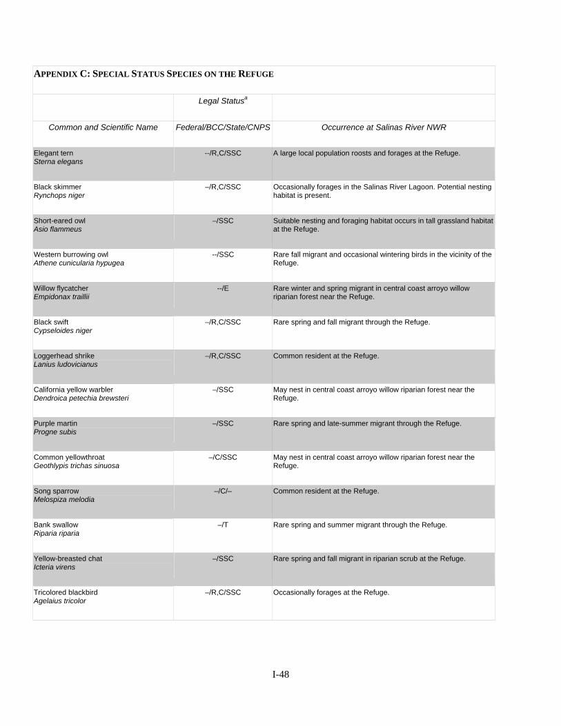
APPENDIX C: SPECIAL STATUS SPECIES ON THE REFUGE
Legal Statusa
Common and Scientific Name Federal/BCC/State/CNPS Occurrence at Salinas River NWR
Elegant tern Sterna elegans
--/R,C/SSC A large local population roosts and forages at the Refuge.
Black skimmer Rynchops niger
–/R,C/SSC Occasionally forages in the Salinas River Lagoon. Potential nesting habitat is present.
Short-eared owl Asio flammeus
–/SSC Suitable nesting and foraging habitat occurs in tall grassland habitat at the Refuge.
Western burrowing owl Athene cunicularia hypugea
--/SSC Rare fall migrant and occasional wintering birds in the vicinity of the Refuge.
Willow flycatcher Empidonax traillii
--/E Rare winter and spring migrant in central coast arroyo willow riparian forest near the Refuge.
Black swift Cypseloides niger
–/R,C/SSC Rare spring and fall migrant through the Refuge.
Loggerhead shrike Lanius ludovicianus
–/R,C/SSC Common resident at the Refuge.
California yellow warbler Dendroica petechia brewsteri
–/SSC May nest in central coast arroyo willow riparian forest near the Refuge.
Purple martin Progne subis
–/SSC Rare spring and late-summer migrant through the Refuge.
Common yellowthroat Geothlypis trichas sinuosa
–/C/SSC May nest in central coast arroyo willow riparian forest near the Refuge.
Song sparrow Melospiza melodia
–/C/– Common resident at the Refuge.
Bank swallow Riparia riparia
–/T Rare spring and summer migrant through the Refuge.
Yellow-breasted chat Icteria virens
–/SSC Rare spring and fall migrant in riparian scrub at the Refuge.
Tricolored blackbird Agelaius tricolor
–/R,C/SSC Occasionally forages at the Refuge.
I-48
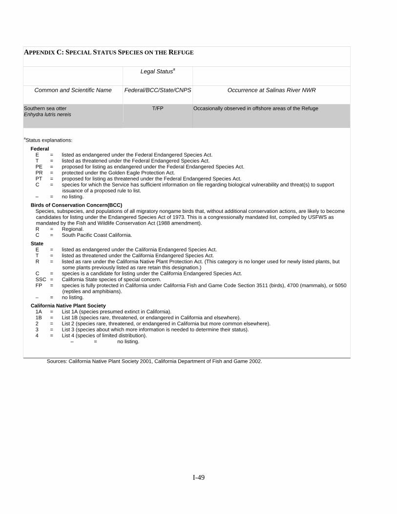
APPENDIX C: SPECIAL STATUS SPECIES ON THE REFUGE
Legal Statusa
Common and Scientific Name Federal/BCC/State/CNPS Occurrence at Salinas River NWR
Southern sea otter Enhydra lutris nereis
T/FP Occasionally observed in offshore areas of the Refuge
aStatus explanations: Federal E = listed as endangered under the Federal Endangered Species Act. T = listed as threatened under the Federal Endangered Species Act. PE = proposed for listing as endangered under the Federal Endangered Species Act. PR = protected under the Golden Eagle Protection Act. PT = proposed for listing as threatened under the Federal Endangered Species Act. C = species for which the Service has sufficient information on file regarding biological vulnerability and threat(s) to support
issuance of a proposed rule to list. – = no listing. Birds of Conservation Concern(BCC) Species, subspecies, and populations of all migratory nongame birds that, without additional conservation actions, are likely to become
candidates for listing under the Endangered Species Act of 1973. This is a congressionally mandated list, compiled by USFWS as mandated by the Fish and Wildlife Conservation Act (1988 amendment).
R = Regional. C = South Pacific Coast California. State E = listed as endangered under the California Endangered Species Act. T = listed as threatened under the California Endangered Species Act.
R = listed as rare under the California Native Plant Protection Act. (This category is no longer used for newly listed plants, but some plants previously listed as rare retain this designation.)
C = species is a candidate for listing under the California Endangered Species Act. SSC = California State species of special concern. FP = species is fully protected in California under California Fish and Game Code Section 3511 (birds), 4700 (mammals), or 5050
(reptiles and amphibians). – = no listing. California Native Plant Society 1A = List 1A (species presumed extinct in California). 1B = List 1B (species rare, threatened, or endangered in California and elsewhere). 2 = List 2 (species rare, threatened, or endangered in California but more common elsewhere). 3 = List 3 (species about which more information is needed to determine their status). 4 = List 4 (species of limited distribution). – = no listing.
Sources: California Native Plant Society 2001, California Department of Fish and Game 2002.
I-49
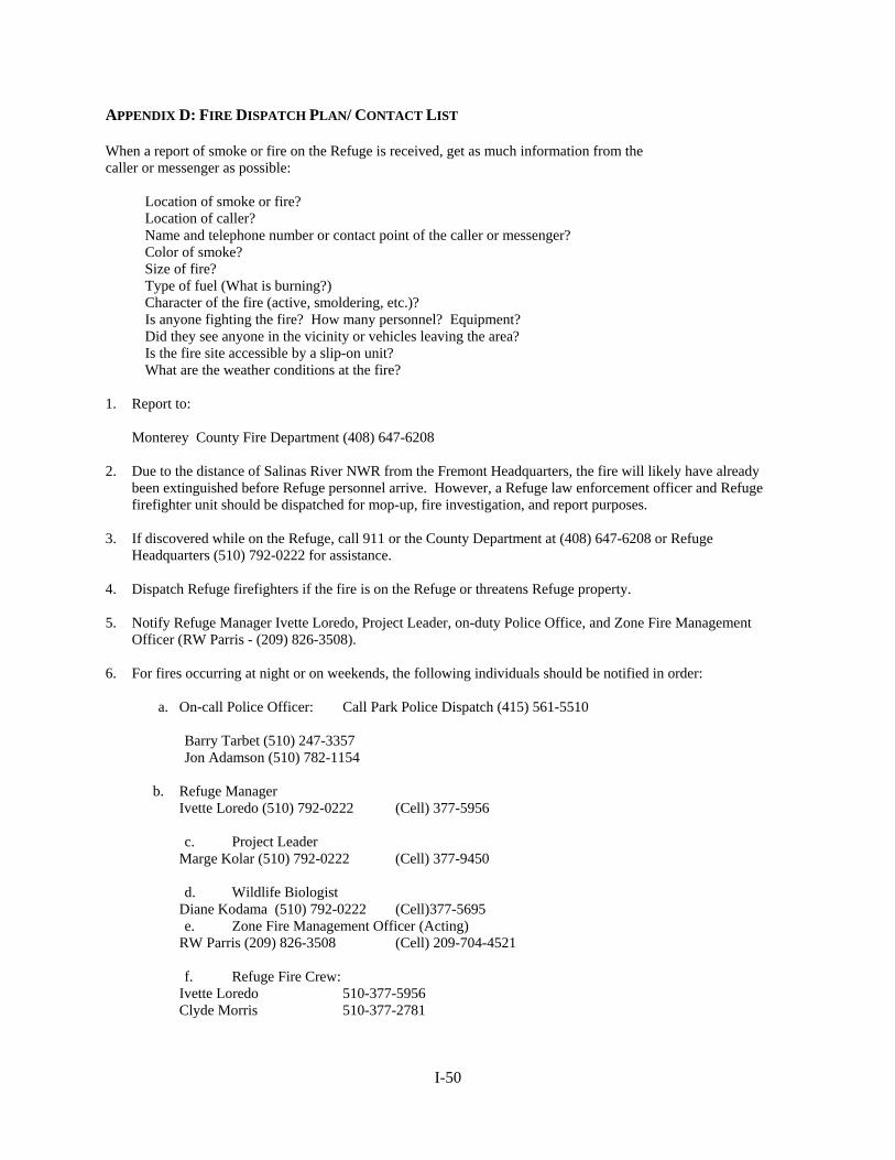
APPENDIX D: FIRE DISPATCH PLAN/ CONTACT LIST When a report of smoke or fire on the Refuge is received, get as much information from the caller or messenger as possible:
Location of smoke or fire? Location of caller? Name and telephone number or contact point of the caller or messenger? Color of smoke? Size of fire? Type of fuel (What is burning?) Character of the fire (active, smoldering, etc.)? Is anyone fighting the fire? How many personnel? Equipment? Did they see anyone in the vicinity or vehicles leaving the area? Is the fire site accessible by a slip-on unit? What are the weather conditions at the fire?
1. Report to:
Monterey County Fire Department (408) 647-6208 2. Due to the distance of Salinas River NWR from the Fremont Headquarters, the fire will likely have already
been extinguished before Refuge personnel arrive. However, a Refuge law enforcement officer and Refuge firefighter unit should be dispatched for mop-up, fire investigation, and report purposes.
3. If discovered while on the Refuge, call 911 or the County Department at (408) 647-6208 or Refuge
Headquarters (510) 792-0222 for assistance. 4. Dispatch Refuge firefighters if the fire is on the Refuge or threatens Refuge property. 5. Notify Refuge Manager Ivette Loredo, Project Leader, on-duty Police Office, and Zone Fire Management
Officer (RW Parris - (209) 826-3508). 6. For fires occurring at night or on weekends, the following individuals should be notified in order:
a. On-call Police Officer: Call Park Police Dispatch (415) 561-5510 Barry Tarbet (510) 247-3357 Jon Adamson (510) 782-1154
b. Refuge Manager Ivette Loredo (510) 792-0222 (Cell) 377-5956
c. Project Leader Marge Kolar (510) 792-0222 (Cell) 377-9450
d. Wildlife Biologist Diane Kodama (510) 792-0222 (Cell)377-5695
e. Zone Fire Management Officer (Acting) RW Parris (209) 826-3508 (Cell) 209-704-4521
f. Refuge Fire Crew: Ivette Loredo 510-377-5956 Clyde Morris 510-377-2781
I-50
Carmen Leong 510-377-9229 Joelle Buffa 510-377-5958 Joy Albertson 510-377-5693 Art Chan 510-377-3119 Juan Flores 510-377-5891 Mike Parker 510-928-0497 Chris Bandy 510-377-5928
g. Other personnel to be involved if necessary:
Dennis Macomber, Regional Fire Management Coordinator, Regional Office: (503) 231-6174 or residence (503) 698-2815 Andy Anderson, Regional Fire Management Officer (503) 231-6175 business or residence (360) 666-5031 Amanda McAdams, Fire Planner, Pacific Region Regional Office: (503) 872-2756 Pam Ensley, Regional Fire Management Coordinator, Regional Office: (503) 231-6174 or residence (360) 835-7004 Roddy Baumann, Regional Prescribed Fire Specialist Regional Office: (503) 231-2075 or (360) 573-9444 residence Mendicino NF Dispatch Willows, CA (888) 663-3479
I-51
APPENDIX E: DELEGATION OF AUTHORITY Salinas River NWR Delegation of Authority for ___________________ Incident _______________________ is assigned as Incident Commander. You have full authority and responsibility for managing the fire suppression activities within the framework of laws, Agency policy, and direction provided in the Wildland Fire Situation Analysis and the Agency Administrator Briefing. Your primary responsibility is to organize and direct your assigned resources for efficient and effective suppression of the fire. You are accountable to the Agency Administrator or the representatives designated below. Specific direction for this incident covering management and environmental concerns are: 1. Protection of life and private property is your highest priority task. 2. Give special consideration to firefighter safety, especially with respect to aviation operations,
working around dozers, snags, and entrapments. Avoid sensitive environmental areas. When in doubt, sacrifice acres not people in your strategic and tactical decisions.
3. You are authorized to utilize helicopters, chainsaws, portable pumps, fireline explosives, and retardant at Salinas River NWR. You are not authorized to use equipment within the _________________________________________.
4. Manage human resources assigned to the fire in a manner that promotes mutual respect and is consistent with the enclosed U.S. Fish & Wildlife Service “Harassment-Free Workplace” policy.
5. Be cost effective; final costs should be no more than 120% of the preferred WFSA alternative. 6. Manage equipment and supplies to ensure losses are within Acceptable Fire Loss/Use Rates. You should takeover management of the incident on or before _________, __________________. _________________________________ ________________ Marge Kolar, Project Leader, Salinas River NWR Date Delegation of Authority - Guidelines for Mitigating the Effects of Fire Suppression LINE BUILDING 1. Do not fall snags on the outside of the line unless they are an obvious safety hazard. 2. On the inside of the line, fall only those snags that would reach the fire line should they burn and
fall over, or if they are an obvious safety hazard. 3. Don’t cut live trees over 12" d.b.h. unless deemed absolutely necessary by the Refuge Manager.
Limbing of these trees, as necessary, should be the first choice. 4. Cut brush or small trees flush with the ground if the area is visible from roads. 5. Lop and scatter cut limbs so the depth will not exceed 15 inches. MOP-UP
I-52
1. Extinguish fire in living trees or snags within 200 feet of the fires perimeter with water or dirt.
Fell those trees as a last resort. 2. If felling occurs in the vicinity of service roads/trails, cut the stumps flush with the ground. 3. Buck fallen trees across service roads/trails only to the extent necessary to facilitate road/trail
passage. AIR OPERATIONS 1. Consider fixed wing delivery of water vs. standard colored retardant. 2. When possible, use long line slings instead of cutting helispots.
I-53
APPENDIX F: NOTIFICATION LIST FOR PRESCRIBED BURNING County Fire Department Reno DiTullio, Chief Monterey County Fire Department 2221 Garden Road Monterey, CA 93940 (408)647-6208 Monterey Bay Unified Air Pollution Control District (MBUAPCD) Amy Taketomo, Senior Air Quality Planner 24580 Silver Cloud Ct. Monterey, CA 93940 (831)647-9411 Gary Page, Point Reyes Bird Observatory, Snowy Plover Monitoring (415) 868-1221 x23 John and Ricky Warriner, Snowy Plover Monitoring (831) 722-5589 Martin Jefferson & Sons, Adjacent Landowner (831) 384-2049 Robert Scattini, Adjacent Landowner (831) 633-3509 x13 City of Marina (831) 384-3715 David Dixon, Cal. Dept. of Parks and Recreation (831) 384-6932 Nikki Nedeff, Big Sur Land Trust (831) 625-5523 Terry Palmisano, Cal. Dept. of Fish and Game (831) 649-2890
I-54
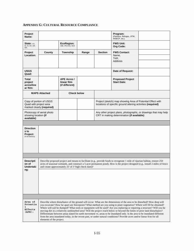
APPENDIX G: CULTURAL RESOURCE COMPLIANCE
Project Name:
Program: (Partners, Refuges, JITW, WSECP, etc.)
State: CA, ID, HI, NV, OR, WA
EcoRegion: CBE, IPE,KCE, NCE
FWS Unit: Org Code:
County Township Range Section
Project Location:
FWS Contact: Name, Tel#, Address
USGS Quad:
Date of Request:
Total project acres/linear ft/m:
APE Acres / linear ft/m (if different)
Proposed Project Start Date:
MAPS Attached Check below
Copy of portion of USGS Quad with project area marked clearly (required)
Project (sketch) map showing Area of Potential Effect with locations of specific ground altering activities (required)
Photocopy of aerial photo showing location (if available)
Any other project plans, photographs, or drawings that may help CRT in making determination (if available)
Directions to Project: (if not obvious)
Describe proposed project and means to facilitate (e.g., provide funds to revegetate 1 mile of riparian habitat, restore 250 acres of seasonal wetlands, and construct a 5-acre permanent pond). How is the project designed (e.g., install 2 miles of fence and create approximately 25' of 3' high check dam)?
Description of Undertaking:
Area of Potential Effects (APE):
Describe where disturbance of the ground will occur. What are the dimensions of the area to be disturbed? How deep will you excavate? How far apart are fenceposts? What method are you using to plant vegetation? Where will fill be obtained? Where will soil be dumped? What tools or equipment will be used? Are you replacing or repairing a structure? Will you be moving dirt in a relatively undisturbed area? Will the project reach below or beyond the limits of prior land disturbance? Differentiate between areas slated for earth movement vs. areas to be inundated only. Is the area to be inundated different from the area inundated today, in the recent past, or under natural conditions? Provide acres and/or linear ft/m for all elements of the project.
I-55
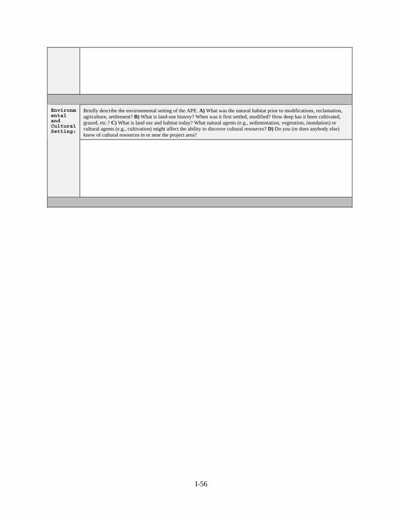
Briefly describe the environmental setting of the APE. A) What was the natural habitat prior to modifications, reclamation, agriculture, settlement? B) What is land-use history? When was it first settled, modified? How deep has it been cultivated, grazed, etc.? C) What is land use and habitat today? What natural agents (e.g., sedimentation, vegetation, inundation) or cultural agents (e.g., cultivation) might affect the ability to discover cultural resources? D) Do you (or does anybody else) know of cultural resources in or near the project area?
Environmental and Cultural Setting:
I-56
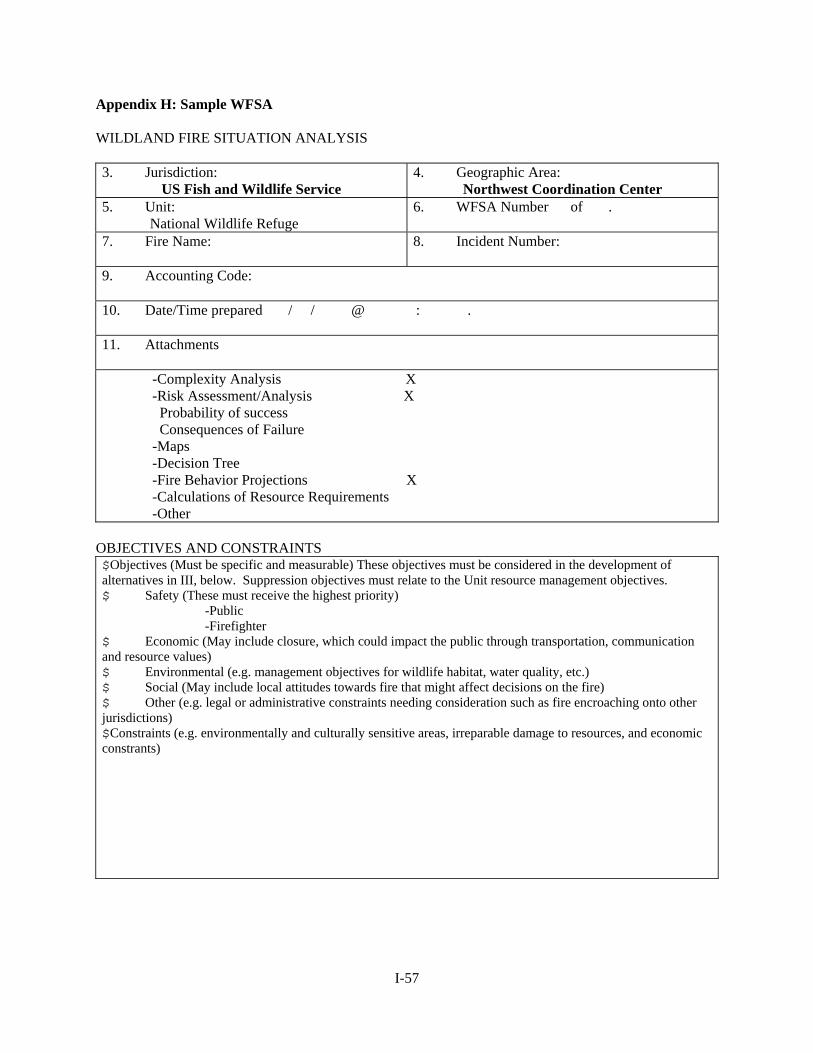
Appendix H: Sample WFSA WILDLAND FIRE SITUATION ANALYSIS 3. Jurisdiction:
US Fish and Wildlife Service 4. Geographic Area:
Northwest Coordination Center 5. Unit:
National Wildlife Refuge 6. WFSA Number of .
7. Fire Name:
8. Incident Number:
9. Accounting Code: 10. Date/Time prepared / / @ : . 11. Attachments
-Complexity Analysis X -Risk Assessment/Analysis X Probability of success Consequences of Failure -Maps -Decision Tree -Fire Behavior Projections X -Calculations of Resource Requirements -Other
OBJECTIVES AND CONSTRAINTS $Objectives (Must be specific and measurable) These objectives must be considered in the development of alternatives in III, below. Suppression objectives must relate to the Unit resource management objectives. $ Safety (These must receive the highest priority)
-Public -Firefighter
$ Economic (May include closure, which could impact the public through transportation, communication and resource values) $ Environmental (e.g. management objectives for wildlife habitat, water quality, etc.) $ Social (May include local attitudes towards fire that might affect decisions on the fire) $ Other (e.g. legal or administrative constraints needing consideration such as fire encroaching onto other jurisdictions) $Constraints (e.g. environmentally and culturally sensitive areas, irreparable damage to resources, and economic constrants)
I-57
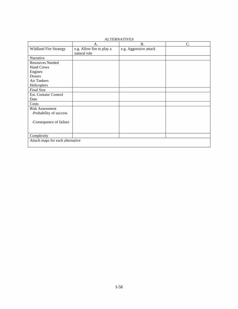
ALTERNATIVES A. B. C.
Wildland Fire Strategy e.g. Allow fire to play a natural role
e.g. Aggressive attack
Narrative Resources Needed Hand Crews Engines Dozers Air Tankers Helicopters
Final Size Est. Contain/ Control Date
Costs Risk Assessment -Probability of success -Consequence of failure
Complexity Attach maps for each alternative
I-58

EVALUATION OF ALTERNATIVES
A. B. C. Evaluation Process Safety Firefighter Aviation Public
Sum of safety values Economic Forage Improvements Recreation Water Wildlife Other
Sum of economic values Environmental Air Visual Fuels T&E Species Other
Sum of environmental values
Social Employment Public Concern Cultural Other
Sum of social values Other Sum of other values TOTAL
ANALYSIS SUMMARY
I-59

A. B. C. Compliance with Objectives Safety Economic Environmental Social Other
Pertinent Data Final fire size Complexity Suppression cost Resource values Probability of success
External/Internal Influences VI. DECISION The Selected Alternative is: . Rationale: Agency Administrator’s Signature Date/Time
I-60
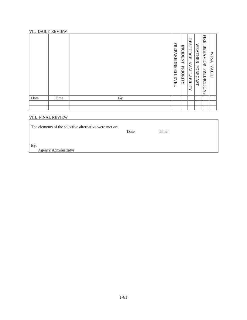
VII. DAILY REVIEW
PREPA
RED
NESS LEV
EL
INC
IDEN
T PRIO
RITY
RESO
UR
CE A
VA
I LAB
ILITY
WEA
THER
FOR
ECA
ST
FIRE B
EHA
VIO
R PR
EDIC
TION
S
WFSA
VA
LID
Date Time By
VIII. FINAL REVIEW The elements of the selective alternative were met on: Date Time: By: Agency Administrator
I-61
APPENDIX I: SAMPLE BURN PLAN Prescribed Fire Plan Refuge or Station Unit Prepared By: Date: Reviewed By: Date:
Refuge Manager Reviewed By: Date:
Prescribed Fire Burn Boss Reviewed By: Date:
Regional Fire Management Coordinator Reviewed By: Date: (Others) The approved Prescribed Fire Plan constitutes the authority to burn, pending approval of Section 7 Consultations, Environmental Assessments, or other required documents. No one has the authority to burn without an approved plan or in a manner not in compliance with the approved plan. Prescribed burning conditions established in the plan are firm limits. Actions taken in compliance with the approved Prescribed Fire Plan will be fully supported, but personnel will be held accountable for actions taken which are not in compliance with the approved plan. Approved By: Date:
I-62
PRESCRIBED FIRE PLAN Refuge: Refuge Burn Number: Sub Station: Fire Number: Name of Area: Unit No. Acres To Be Burned: Perimeter Of Burn: Legal Description: Lat. Long. T R S County: Is a Section 7 Consultation being forwarded to Fish and Wildlife Enhancement for review? Yes No (circle). (Page 2 of this PFP should be a refuge base map showing the location of the burn on Fish and Wildlife Service land.) The Prescribed Fire Burn Boss/Specialist must participate in the development of this plan. I. GENERAL DESCRIPTION OF BURN UNIT Physical Features and Vegetation Cover Types (Species, height, density, etc.): Primary Resource Objectives of Unit (Be specific. These are management goals): Objectives of Fire (Be specific. These are different than management goals): Acceptable Range of Results (Area burned vs. unburned, scorch height, percent kill of a species, range of litter removed,
I-63
II. PRE-BURN MONITORING Vegetation Type Acres % FBPS Fuel Model Total Habitat Conditions (Identify with transect numbers if more than one in burn unit.): Type of Transects: Photo Documentation (Add enough spaces here to put a pre-burn photo showing the habitat condition or problem you are using fire to change/correct. A photo along your transect may reflect your transect data.): Other:
I-64
III. PLANNING AND ACTIONS Complexity Analysis Results: Site preparation (What, when, who & how. Should be done with Burn Boss): Weather information required (who, what, when, where, how, and how much): Safety considerations and protection of sensitive features (Adjacent lands, visitors, facilities, terrain, etc., and needed actions. Include buffer and safety zones. Be specific, indicate on a burn unit map. Map should be a USGS quadrangle if possible, so ridges, washes, water, trails, etc. can be identified.) Special Safety Precautions Needing Attention (Aerial ignition, aircraft, ignition from boat, etc.): Media Contacts (Radio stations, newspaper, etc., list with telephone numbers): Special Constraints and Considerations (Should be discussed with Burn Boss): Communication and Coordination on the Burn (Who will have radios, frequencies to be used, who will coordinate various activities.):
I-65
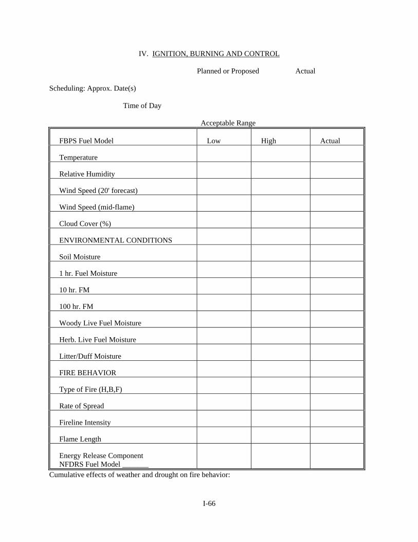
IV. IGNITION, BURNING AND CONTROL Planned or Proposed Actual Scheduling: Approx. Date(s) Time of Day Acceptable Range
FBPS Fuel Model Low High Actual
Temperature
Relative Humidity
Wind Speed (20' forecast)
Wind Speed (mid-flame)
Cloud Cover (%)
ENVIRONMENTAL CONDITIONS
Soil Moisture
1 hr. Fuel Moisture
10 hr. FM
100 hr. FM
Woody Live Fuel Moisture
Herb. Live Fuel Moisture
Litter/Duff Moisture
FIRE BEHAVIOR
Type of Fire (H,B,F)
Rate of Spread
Fireline Intensity
Flame Length
Energy Release Component NFDRS Fuel Model _______
Cumulative effects of weather and drought on fire behavior:
I-66
Ignition Technique (Explain and include on map of burn unit. Use of aerial ignition must be identified in this plan. Last minute changes to use aircraft will not be allowed and will be considered a major change to the plan. This will require a resubmission): Prescribed Fire Organization (See Section VII, Crew and Equipment Assignments. All personnel and their assignments must be listed. All personnel must be qualified for the positions they will fill.) Other (If portions of the burn unit must be burned under conditions slightly different than stated above, i.e., a different wind direction to keep smoke off of a highway or off of the neighbors wash, detail here.) Prescription monitoring (Discuss monitoring procedure and frequency to determine if conditions for the burn are within prescription):
I-67
V. SMOKE MANAGEMENT Make any Smoke Management Plan an attachment. Permits required (who, when): Distance and Direction from Smoke Sensitive Area(s): Necessary Transport Wind Direction, Speed and Mixing Height (Explain how this information will be obtained and used): Visibility Hazard(s) (Roads, airports, etc.): Actions to Reduce Visibility Hazard(s): Residual Smoke Problems (Measures to reduce problem, i.e., rapid and complete mop-up, mop-up of certain fuels, specific fuel moistures, time of day, etc.): Particulate emissions in Tons/Acre and how calculated (This should be filled in after the burn so more precise acreage figures can be used):
I-68
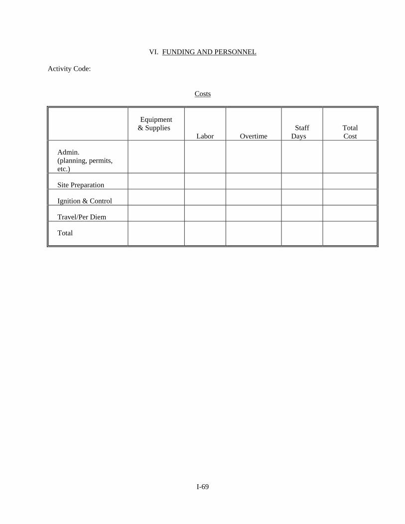
VI. FUNDING AND PERSONNEL Activity Code: Costs
Equipment & Supplies
Labor
Overtime
Staff Days
Total Cost
Admin. (planning, permits, etc.)
Site Preparation
Ignition & Control
Travel/Per Diem
Total
I-69
VII. BURN-DAY ACTIVITIES Public/Media Contacts on Burn Day (List with telephone numbers): Crew & Equipment Assignments (List all personnel, equipment needed, and assignments. The following is not an all-inclusive list for what you may need.) Burn Boss/Manager - Ignition Specialist - Ignition Crew - Holding Specialist - Holding Crew - Aircraft Manager - FWBS - Dispatcher- Other - Crew Briefing Points (Communications, hazards, equipment, water sources, escape fire actions, etc., to be done by Burn Boss. Refer to Safety Considerations in Planning Actions and points listed below): Ignition Technique (Methods, how, where, who, and sequence. Go over what was submitted in Section IV and any changes needed for the present conditions.) Attach ignition sequencing map if necessary: Personnel Escape Plan Special Safety Requirements: Go-No-Go Checklist: Holding and Control:
Critical Control Problems:
I-70
Water Refill Points:
Other:
Contingency Plan for Escaped Fire (Are there crews standing by to initial attack or will people doing other jobs be called upon to do initial attack, who must be called in case of an escape, what radio frequencies will be used, etc.) Mop Up and Patrol: Rehabilitation Needs: DI 1202 Submission Date:________________________________________ Special Problems:
I-71
VIII. CRITIQUE OF BURN Were burn objectives within acceptable range of results? (Refer to Section I): What would be done differently to obtain results or get better results? Was there any deviation from plan? If so, why? Problems and general comments: IX. POST-BURN MONITORING Date: Refuge Burn Number: Length of Time after Burn: Vegetative Transects: Comments on Habitat Conditions, etc.: Photo Documentation: Other: X. FOLLOW-UP EVALUATION Date: Refuge Burn Number: Length of Time after Burn: Vegetative Transects: Comments on Habitat Conditions, etc.: Photo Documentation: Other:
I-72