route 38 transportation study northern middlesex council of governments april 8, 2014 april 8, 2014
TRANSCRIPT

Route 38 Transportation Study
Northern Middlesex Council of Governments
April 8, 2014

Purpose and Goals
Evaluate transportation conditions within the Route 38 corridor◦ Traffic Operations◦ Bicycle and Pedestrian Accommodations◦ Safety◦ Access
Study Goals:◦ Assess existing and future operating conditions ◦ Identify deficiencies and needs ◦ Outline recommendations for addressing
existing and anticipated transportation needs

Zoning and Land Use6.3 mile corridor containing 431
parcels (968.63 acres of land)Base Zoning Characteristics
◦Commercial – 270 parcels (51.73% land area)
◦Industrial – 51 parcels (4.05%)◦Residence 40 – 86 parcels (28.18%)◦Multi-Family – 8 parcels (14.59%)◦Transitional – 14 parcels (1.18%)◦Municipal – 2 parcels (0.27%)

Overlay Zoning Districts◦Wireless Communications Facilities
◦Village Mixed-Use Overlay District◦Village Residential Overlay District◦Town Center Overlay District◦Community Village Overlay District
◦South Village Overlay District
Overlay Zoning Districts

Land Use CharacteristicsLand Use No. of
ParcelsAcreage % Acreage
Commercial 142 352.53 36.39
Residential 224 225.53 23.28
Exempt 19 245.23 25.32
Industrial 3 5.83 0.60
Vacant Industrial
8 18.31 1.90
Vacant Developable
16 76.45 7.90
Vacant Undevelopable
17 36.60 3.78
Potentially Developable
1 4.16 0.43
Residential Open Land
1 4.00 0.41
Totals 431 968.63 100.00
Land Use Characteristics

Study Methodology -Transportation
Evaluate Existing Traffic Operations◦ ATR and Turning Movement Counts◦ Traffic Safety Analysis◦ Inventory of Pedestrian and Bicycle Facilities◦ Level of Service (LOS) and Delay Analysis
Evaluate Future Traffic Conditions◦ Forecasted Traffic Volumes based on
background growth and known development proposals
◦ Level of Service (LOS) and Delay Analysis• Formulate Improvement Recommendations

Study Area Segments

Study Area Segments
Lowell City Line to Astle/Pike Street Astle/Pike Street to Pleasant Street Pleasant Street to Chandler Street Chandler Street to Victor Drive Victor Drive to Shawsheen Street Shawsheen Street to South Street South Street to Wilmington Town
Line
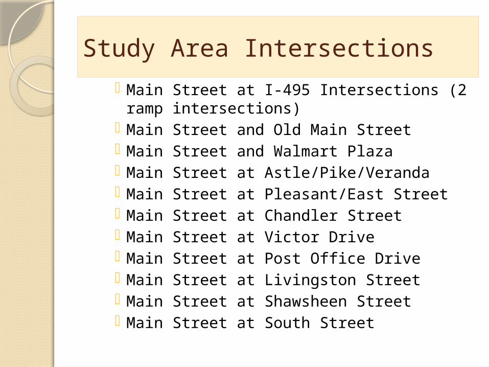
Study Area Intersections Main Street at I-495 Intersections (2 ramp
intersections) Main Street and Old Main Street Main Street and Walmart Plaza Main Street at Astle/Pike/Veranda Main Street at Pleasant/East Street Main Street at Chandler Street Main Street at Victor Drive Main Street at Post Office Drive Main Street at Livingston Street Main Street at Shawsheen Street Main Street at South Street
Study Area Intersections

Average Daily Traffic VolumesLocation
Average Daily Traffic (ADT) vehicles per day
(vpd)
P.M. Peak Hour Volume
A.M. Peak Hour Volume
Route 38 at Lowell City Line
29,400 3,184 2,128
Route 38 south of I-495
27,300 2,583 1,862
Route 38 north of Capitol Avenue
23,200 2,171 1,621
Route 38 north of Dewey Street
22,100 1,984 1,889
Route 38 South of Pleasant Street
19,000 1,679 1,334
Route 38 south of Chandler Street
20,100 1,826 1,447
Route 38 north of Shawsheen Street
22,400 1,965 1,454
Route 38 south of DeCarolis Drive
19,700 1,567 1,564
Route 38 south of South Street
15,100 1,365 1,382

Existing Operating Conditions at Study Area Intersections
INTERSECTION
Existing Conditions
AM Peak Hour PM Peak Hour
Control Delay (sec/veh)
LOSControl Delay
(sec/veh)LOS
Route 38 and I-495 SB Ramps 29.8 C 47.7 DRoute 38 and I-495 NB Ramps 47 D 39.7 DRoute 38 and Old Main Street 13 B 7.1 ARoute 38 and Walmart Plaza 4.8 A 13 BRoute 38 and Astle/Pike Street 18.9 B 45.7 DRoute 38 and Pleasant Street 26.5 C 39.8 DRoute 38 and Chandler Street 11.4 B 15.3 BRoute 38 and Victor Drive 11.7 B 11.4 BRoute 38 and Post Office Drive 7.2 A 10.1 BRoute 38 and Livingston Street 16.8 B 40 DRoute 38 and Shawsheen Street 54.5 D 72.4 ERoute 38 and South Street 60.7 E 68.8 E

Existing Traffic Operations
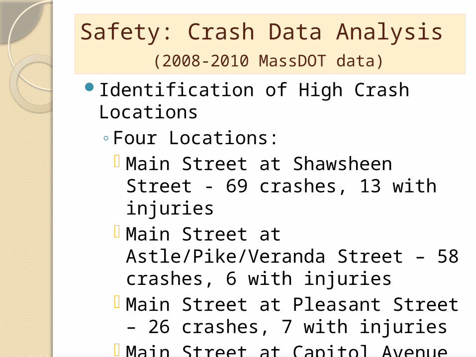
Safety: Crash Data Analysis (2008-2010 MassDOT data)
Identification of High Crash Locations◦Four Locations: Main Street at Shawsheen Street -
69 crashes, 13 with injuries Main Street at Astle/Pike/Veranda
Street – 58 crashes, 6 with injuries Main Street at Pleasant Street – 26
crashes, 7 with injuries Main Street at Capitol Avenue – 32
crashes, 4 with injuries

Pedestrian Facilities Inventory
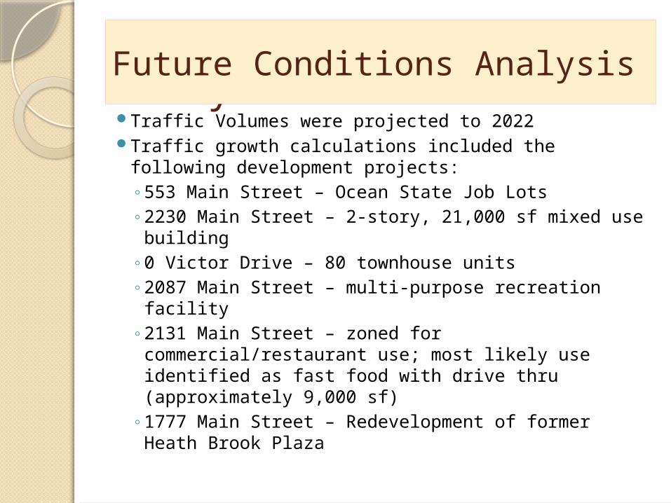
Future Conditions AnalysisTraffic Volumes were projected to 2022 Traffic growth calculations included the following
development projects:◦ 553 Main Street – Ocean State Job Lots◦ 2230 Main Street – 2-story, 21,000 sf mixed use
building◦ 0 Victor Drive – 80 townhouse units◦ 2087 Main Street – multi-purpose recreation facility◦ 2131 Main Street – zoned for
commercial/restaurant use; most likely use identified as fast food with drive thru (approximately 9,000 sf)
◦ 1777 Main Street – Redevelopment of former Heath Brook Plaza
Future Conditions Analysis

2022 Traffic Operations with Anticipated Development Projects
Intersection
2022 Conditions with Anticipated Development
AM Peak Hour PM Peak Hour
Control Delay (sec/veh) LOS
Control Delay (sec/veh) LOS
Route 38 and I-495 SB Ramps 29.5 C 53.0 DRoute 38 and I-495 NB Ramps 59.0 E 54.9 DRoute 38 and Old Main Street 13.4 B 8.0 ARoute 38 and Walmart Plaza 5.1 A 10.6 BRoute 38 and Astle/Pike Street 56.1 E 90.2 FRoute 38 and Pleasant Street 40.5 D 51.6 DRoute 38 and Chandler Street 12.9 B 33.1 C
Route 38 and Victor Drive 17.6 B 21.7 CRoute 38 and Post Office Drive 9.2 A 13.2 BRoute 38 and Livingston Street 27.4 C 182.1 FRoute 38 and Shawsheen Street 88.2 F 113.8 F
Route 38 and South Street 125.9 F 60.2 E

2022 Intersection Level of Service with Recommended Improvements
Intersection
2022 LOS with recommended Improvements
Recommended Operational Improvements
AM Peak Hour PM Peak Hour
Control delay (sec/veh)
LOS Control delay (sec/veh)
LOS
Route 38 and I-495 SB Ramps
29.5 C 53.0 D None
Route 38 and I-495 NB Ramps
49.0 D 54.9 D Signal timing only: add time to westbound left turn phase
Route 38 and Old Main Street
13.4 B 8.0 A None
Route 38 and Walmart Plaza
5.1 A 10.6 B None
Route 38 and Astle/Pike Street
54.5 D 38.9 D Add a SB Main St right turn lane, a NB Main St exclusive through lane, and adjust signal timing
Route 38 and Pleasant Street
40.5 D 51.6 D None
Route 38 and Chandler Street
12.9 B 33.1 C None
Route 38 and Victor Drive
17.6 B 21.7 C None
Route 38 and Post Office Drive
9.2 A 13.2 B None
Route 38 and Livingston Street
18.3 B 24.6 C Add a NB Main St exclusive through lane, add a WB Livingston St Right turn lane, adjust signal timing
Route 38 and Shawsheen Street
34.4 C 44.3 D NB and SB Main St Exclusive Through lanes, signal timing changes
Route 38 and South Street 46.3 D 47.7 D Combine EB and WB South Street signal phases, adjust signal timing

Two-Way Left Turn LanesReduction of delays at mid-block
access areas caused by left turning vehicles blocking mainline
Safety benefits (can reduce crashes)Emergency Vehicle benefitsFour Candidate Locations:

Two-Way Left Turn Lane Locations

Other Recommendations
Access Management
◦ Establish a partnership between the Town and MassDOT to address future access issues along corridor: Limit the number of conflict points at
Driveway Locations Separate Conflict Points Reduce the interference of Through Traffic
(two-way left turn lanes) Provide Adequate On-Site Circulation and
Storage in Parking Areas Provide adequate vehicle stacking for drive
through lanes

Other Recommendations (continued)
Transportation Demand Management◦ Encouraging a shift from single occupancy vehicle trips to
non-single occupant modes; shifting trips out of peak periods◦ Adopt a TDM Policy
Encourage use of transit, ridesharing, bicycling, walking or travel outside of peak periods
Participation in a Transportation Management Association (TMA)
Alternative Work Programs – Encourage Telecommuting/ Flextime
Work toward providing: ADA Compliant Sidewalks Bicycle Facilities Land Use policies that encourage mixed-use
development Enhances streetscaping and pedestrian amenities

Recommendations for Improving Traffic Operations
Corridor-Wide Traffic Signal Optimization; Coordination of Traffic Signals
Post Office Drive to Shawsheen Street I-495 Interchange Area from Clark Road to Old Main Street
Signal Phasing Modifications Main Street at South Street
Need for Increased Capacity at some locations: Main Street at Livingston Street – add a WB Livingston St.
right turn lane and NB Main St through lane Main Street at Astle/Pike Streets – add a SB Main St. right
turn lane and NB exclusive through lane Main Street at Shawsheen Street – additional NB and SB
Main St through lanes Widen Main Street to four lanes between Livingston St. and
Shawsheen St.

Recommendations for Bicycle and Pedestrian Facilities Bicycle and Pedestrian Accommodations
◦Where possible, include 5-foot shoulders to accommodate bicycles
◦Where 5-foot shoulders are not possible, “Share the Road” markings (Sharrows) may be substituted
◦Encourage the inclusion of bicycle storage facilities
◦Develop a continuous, ADA compliant sidewalk network
Develop performance criteria relative to transportation for inclusion in the Town’s Zoning Bylaws

Thank You!Questions?Contact information:
◦NMCOG phone number : 978-454-8021 Beverly Woods: [email protected] Justin Howard: [email protected]