route 10 – north lantau to yuen long highway section between north lantau …€¦ · ·...
TRANSCRIPT

Route 10 – North Lantau to Yuen Long HighwaySection between North Lantau to So Kwun Wat
PURPOSE
This paper informs Members of the Route 10 – North Lantau to YuenLong Highway (NLYLH) project, especially the provision of link roads at SiuLam and So Kwun Wat.
BACKGROUND OF ROUTE 10 (NLYLH)
2. Route 10 (NLYLH), a proposed dual 3-lane highway of about12.8 km long, will connect Lam Tei in North West New Territories to NortheastLantau via So Kwun Wat and Tsing Lung Tau. A site plan of the route is atAnnex A.
3. Route 10 (NLYLH) will perform the following functions –
(a) to provide an alternative external road link for Lantau and theairport;
(b) to meet anticipated population and employment growth in north-westNew Territories; and
(c) to meet forecast traffic demand generated by cross boundaryactivities.
4. The route comprises the following sections –
(a) Southern Section (8.3 km) – From North Lantau to So Kwun Wat
(b) Northern Section (4.5 km) – From So Kwun Wat to Lam Tei
(c) Two link roads to connect Tuen Mun Road –
(i) dual-2 So Kwun Wat Link Road which connects R10 (NLYLH)to Tuen Mun Road at So Kwun Wat, for vehicles to enter orleave the Southern Section; and

- 2 -
(ii) dual-2 Siu Lam Link Road which connects R10 (NLYLH) toTuen Mun Road at Siu Lam, for vehicles to enter or leave theNorthern Section.
THE NEED FOR CONNECTIONS BETWEEN ROUTE 10 (NLYLH)AND TUEN MUN ROAD
5. It is fundamental to the design of new trunk routes that connectionswith adjacent or intersecting routes are provided to enhance the utility of theroute. In the case of Route 10 (NLYLH), which runs in a north-south directionto the east of Tuen Mun Road before crossing it at Tsing Lung Tau, aninterchange between Route 10 (NLYLH) and Tuen Mun Road would allowtraffic from Route 10 (NLYLH) to access Tsuen Wan and Kowloon.
6. Highways Department commissioned a Feasibility Study in 1995,which examined several possible corridors for the Route 10 (NLYLH)mainline. This study found that an interchange with Tuen Mun Road was soimportant that it was one of the principal determining factors in the selection ofthe optimal corridor for Route 10 (NLYLH). Two interchange options wereconsidered with Tuen Mun Road, one at Tsing Lung Tau, and the other at SoKwun Wat. At Tsing Lung Tau the consultant concluded that a connection withTuen Mun Road was not feasible. The Study finally recommended that thenecessary movements should be provided by means of a link road through theSo Kwun Wat valley instead.
7. Highways Department subsequently commissioned the Investigationand Preliminary Design Assignment of Route 10 (NLYLH) in 1998. Theintention of this study was to refine the alignment and to examine in more detailthe predicted traffic demands, and to consider the expected impacts of the routeon the environment and the current drainage regime. Traffic studies haveindicated a considerable demand for the link in the So Kwun Wat valley. In2016, the demand predicted was in the order of 2500 passenger car units ineach direction, requiring a dual 2-lane link.
INVESTIGATIONS INTO THE POSSIBLE LOCATIONS FOR THEROUTE 10 (NLYLH) / TUEN MUN ROAD CONNECTION

- 3 -
8. HyD has looked into the possible locations for the connection withTuen Mun Road at three locations, including So Kwun Wat, Siu Lam and TsingLung Tau. Details of the considerations are set out in the ensuing paragraphs.

- 4 -
So Kwun Wat
9. The Feasibility Study conducted prior to the Investigation andPreliminary Design Assignment had recommended that one single link beprovided between Route 10 (NLYLH) and Tuen Mun Road in the So KwunWat valley. Provision of a link across the So Kwun Wat valley is feasible, butthere were a number of difficulties with the Feasibility Study alignment. Thelocation of the link road ran diagonally across the floor of the valley andoccupied much of the developable land, sterilising a residential site at thewestern end of the valley. The route also infringed designated Village areanecessitating major land resumptions and village relocation. Other majorconstraints included the property developments to the west of the valley, WSDfacilities and a fung shui hill at the eastern end of the valley. Location of thelink on embankment across both the valley and the major stream courses hadsignificant drainage impacts. There were also technical difficulties in achievingacceptable highway design standards for certain movements, especially thenorthward movement from the link road onto Route 10 (NLYLH), and thesouthward movement onto Tuen Mun Road from the link.
10. Modification of the Feasibility Study scheme was considered, but theresultant scheme still could not achieve the minimum design standards for aroad of this nature and therefore failed to overcome the major shortcomings ofthe Feasibility Study scheme.
11. For this reason an alternative alignment was developed (Annex B).The So Kwun Wat Link Road was relocated north onto the slopes of the valleyaway from developable areas. In this location the link road also has a muchlesser impact on existing properties, and because it is supported on viaduct ithas no significant adverse drainage impact on the valley. The detailedinvestigation of environmental impacts carried out in the environmental impactassessment has concluded that with appropriate mitigation measures the impactcould meet the established standards.
Siu Lam
12. With the So Kwun Wat Link Road relocated to the north, thenorthbound connections from the link road to Route 10 (NLYLH) could not beprovided due to site constraint and has to be relocated. These connections werereplaced by means of a new link, the Siu Lam Link Road. Studies showed thatfor north-south movements between Route 10 and Tuen Mun Road, traveldistance could be reduced by 2.4 km. This resulted in substantial savings in

- 5 -
journey time, as well as a reduction in traffic flows along Tuen Mun Roadbetween So Kwun Wat and Siu Lam. At the same time it achieved the desirabledesign standards.
13. The Siu Lam Link Road was developed during the Investigation andPreliminary Design Assignment following a review of constraints in the SiuLam area. The constraints were considerable. They include the WSD tunnelsand reservoirs, the development at Siu Lam and the Marine Police Base,amongst others. The proposed Siu Lam Link Road met all design criteria forhighway standards, and in addition, it provides a bypass relieving the traffic onTuen Mun Road between So Kwun Wat and Siu Lam.
Tsing Lung Tau
14. The area of Tsing Lung Tau where the Tsing Lung Bridge will crossthe Tuen Mun Highway is highly constrained by existing developments,existing land features and the proposed locations of tunnel portal, Tsing LungBridge anchorage and the bridge tower.
15. An interchange at Tsing Lung Tau or any form of connections therewas considered not feasible. This was due to the limited space and difficultterrain at the Tsing Lung Tau area. Furthermore, construction work wouldinvolve extensive earthwork requiring lane closures on the Tuen Mun Road tomitigate against risk of falling boulders. The interchange will be very close toexisting properties causing severe environmental impacts. Most of the sliproads would be in tunnel and will have to be designed to sub-standard highwaygeometry with steep gradients and tight radii which will be hazardous tomotorists. In view of unsafe designs, disruptions to Tuen Mun Road andenvironmental concerns, construction of an interchange at Tsing Lung Tau wasconsidered not feasible.
TRAFFIC IMPACT ON TUEN MUN ROAD WITH THE PROVISIONOF THE LINK ROADS
16. There is a misconception that the proposed Siu Lam Link Road willfeed in more traffic onto the already congested section of Tuen Mun Road atSiu Lam. Much of the traffic in the Siu Lam Link Road is in fact diverted fromTuen Mun Road, and is therefore not injecting additional traffic onto Tuen MunRoad at Siu Lam. The addition of Tsing Lung Bridge will provide relief toTuen Mun Road for traffic from North West New Territories to Lantau.

- 6 -
17. According to the 2016 AM peak traffic forecast for the recommendedscenario, the eastbound traffic flow between Siu Lam and Ting Kau is about6500 pcus. This has taken into account the traffic flow of about 2500 pcusjoining and 1800 pcus leaving Tuen Mun Road via Siu Lam Link Road and SoKwun Wat Link Road respectively. Tests have shown no significant increasein traffic on Tuen Mun Road east of Siu Lam Link Road after the completion ofRoute 10. The conditions so forecast for this section of Tuen Mun Road arequite close to the existing traffic conditions in terms of morning peak hourthroughput.
OBJECTIONS TO THE GAZETTED SCHEME
18. The Southern Section of Route 10 (NLYLH) was gazetted under theRoads (Works, Use and Compensation) Ordinance on 28 July 2000. During theobjection period, 577 objection letters were received. Most of the objectionswere from the residents of Palatial Coast. Since receiving the objections,Highways Department has been contacting the objectors in order to clarify anymisunderstanding that may exist on the proposed scheme and to ascertainwhether the objectors are willing to withdraw their objections. To address theconcerns of the residents of the Palatial Coast, HyD has agreed with theresidents to hold monthly meeting to address their concerns over the proposedSiu Lam Link Road. Highways Department is prepared to adopt less thandesirable standards for the design of the link road. Four options are now beingstudied, which include shifting of the alignment and lowering the level of theroad.
REVIEW OF THE SIU LAM LINK ROAD (SLLR)
19. Details of the four alternative options being studied are shown inFigures Nos. 596/RPT/H301 to 596/RPT/H304 attached at Annex C. They arebriefly described as follows.
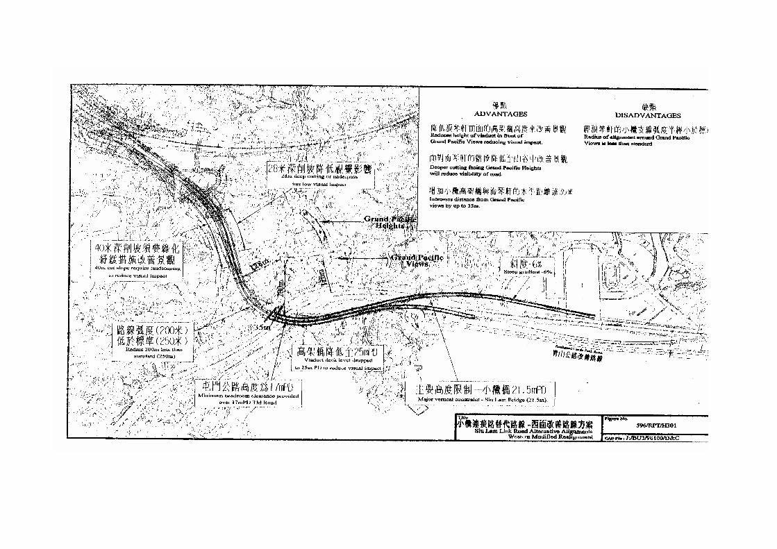
Option 1 - Western Realignment (Figure No. 596/RPT/H301)
20. This realignment follows the existing SLLR horizontal alignmentexcept where it passes in front of Grand Pacific Views (GPV) of Palatial Coastand over Tuen Mun Road. Here the level of the SLLR has been dropped from43mPD in the gazetted scheme to 25mPD, and the alignment shifted a further35m away from GPV. This will further reduce visual, noise and air quality
- 7 -
impacts. The horizontal realignment increases the distance of the link roadfrom the front of GPV to about 200m. On the western side the distance fromGPV remains at about 125m. The reduced SLLR level results in deeper cutslopes to the west of GPV which would make the SLLR less visible to theresidents of Grand Pacific Heights (GPH) of Palatial Coast.
Option 2 – Western Underpass (Figure No. 596/RPT/H302)
21. This option follows a similar route to Option 1, but is a moreexaggerated realignment. It diverges vertically from the existing alignment asit passes in front of the Marine Police Base and GPV. Here the level of theSLLR has also been dropped from 43mPD to 25mPD. It passes over Tuen MunRoad in an arc which shifts the SLLR by up to 90m west of the gazettedalignment and into the adjacent hillside. The minimum distance of the linkfrom GPV is about 200m. The link passes into tunnel to the west of GPH,exiting in a cutting 30m deep, which further reduces visibility from GPH.
Option 3 – Eastern Underpass (Figure No. 596/RPT/H303)
22. This alignment passes east of GPV under the Siu Lam Hospital afterfirst passing over the Siu Lam interchange at a high level. Only one crossing ofTuen Mun Road is required. Clearance under the WSD access road to the northof the hospital is minimal and this section would have to be constructed as a cutand cover tunnel, with temporary road diversions. North of the WSD accessroad and opposite GPV/GPH, the alignment is on a viaduct for 100m across avalley after which it is at grade, with retaining walls on the hillside. At thispoint the alignment is about 120m from GPH. Visual impact would bemitigated by bunding, plantings and landscaping. A noise barrier would berequired. At the northern end of GPH the alignment passes onto viaduct acrossthe Siu Lam valley, passing onto both sides of the Route 10 mainline and intounderpasses before merging with the mainline.
Option 4 – Eastern Tunnel (Figure No. 596/RPT/H304)
23. The eastern tunnel option diverges from the existing SLLR alignmentat the Tai Lam nullah. It passes north-west over Castle Peak Road on a bridge,and then into tunnel between the Siu Lam Prison and Hospital at a lower levelthan Option 3. Only a single crossing of Tuen Mun Road is required. Verticalclearance above Castle Peak Road is minimal. Notwithstanding this a steepgradient is required on the southbound SLLR carriageway between the tunnelsouth portal and the junction with Tuen Mun Road. The tunnel portal is veryclose to the security walls of the Siu Lam facility. The alignment is visible to

- 8 -
blocks 9 and 10 of GPH which are about 125m away. After crossing the SiuLam valley on viaduct it passes onto either side of the Route 10 mainline andinto underpasses before merging with the mainline.
24. The above four options are developed with a view to accommodatingthe concerns of the residents of the Palatial Coast as far as possible. Thesewere presented to the Tuen Mun District Council (TMDC) at its specialmeeting held on 5 December 2000. The members of the TMDC in generalsupported the Option 2. These options will be presented to the residents inFebruary 2001 and their comments will be incorporated as far as possible.
ADVICE SOUGHT
25. Members are invited to note the content of this paper.
Transport BureauFebruary 2001

Annex ARoute 10 - North Lantau to Yuen Long Highway
附件㆒
十號幹線 - 北大嶼山至元朗公路


Annex BSo Kwun Wat Link Road
附件㆓
掃管笏連接路


Annex CSiu Lam Link Road Alternative Alignments
附件㆔
小欖連接路替代方案