rockin’ - ccghtccght.org/wp-content/uploads/2012/05/geology_booklet.pdf · rockin’ the causeway...
TRANSCRIPT

Rockin’the
Causeway Coast & Glens
A Visitors Guide to the Geology of the Causeway Coast & Glens

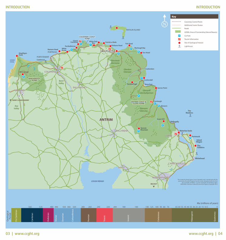
INTRODUCTION INTRODUCTION
01 | www.ccght.org www.ccght.org | 02
The Causeway Coast & Glens provide an opportunity to study anunparalleled variety of geology in a small area. The rocks wereformed in a range of environments from arid desert, warmtropical seas, explosive volcanic eruptions, to cold glacialconditions. Hints and clues to this geological history are allaround us, in the cliffs, mountains and beaches that make up ournatural landscape and in the rocks beneath our feet. With thisbooklet, take a tour of the Causeway Coast & Glens, and explorehow this wonderfully scenic area of Northern Ireland came to bethe shape it is today.
Geological History of The Causeway Coast & Glens - A Brief OverviewSome 500 million years ago, what we now know as Irelandexisted as a number of discrete areas of land and sea floor withinan ancient ocean called Iapetus. The affect of plate movementsthrough time carried the continents across the Earth’s surface,eventually closing this ocean. The continental collisions whichoccurred as the ocean contracted altered the mudstones andsandstones into other rock types known as schists. These rocks,which are among the oldest in Northern Ireland, can be foundtoday in Murlough Bay.
Around 400 million years ago, the Iapetus Ocean had closed andthe mountains in Northern Ireland resembled the Himalayas inscale. Ireland and Britain were situated in the rain shadow of theCaledonian mountain chain and experienced climate conditionsnot dissimilar to Death Valley in California. Erosion of theseupland areas generated the puddingstone conglomerates andsandstones formed in the hot desert conditions that occurredduring the Devonian Period (420 – 355 million years ago) andwhich can be found around Cushendun and Cushendall. Theprevailing conditions at this time also led to the evolution of fishinto amphibians, which was a major advancement for animal lifeon land.
Flooding of this desert landscape heralded the beginning of theCarboniferous Period (355 – 290 million years ago), when Irelandwas covered by shallow tropical seas and deltas. Sediments fromthis era comprise limestone and sandstone formed within majorriver deltas in what is now the Ballycastle area. Abundant growthin plants in the warm and moist conditions lead to anaccumulation of decayed vegetation, forming the coal seamssuch as those found in Ballycastle. Northern Ireland continued to
experience hot dry conditions during the Triassic Period (250 -205 million years ago), due to its location close to the currentSahara Desert. Evaporation left behind large quantities of salt,including the deposits preserved and mined near Carrickfergus.By the late Triassic Period, marine conditions returned andreptiles emerged as the dominant life form on Earth.
The Jurassic Period (205 - 145 million years ago) is the bestknown geological period and is associated with dinosaurs onEarth. Evidence from the Jurassic period can be seen at theWaterloo Beds, Larne where fossils such as a mmonites and otherremains of marine life can be found.
The Cretaceous period (145 - 65 million years ago), brought withit raised sea levels and the return of deeper marine conditions.During this period, shells and the remains of dead microscopicmarine plants known as coccoliths were deposited on the seabed, which over time led to the formation of chalk. This chalk,which is a pure form of limestone, can now be seen in the cliffs atWhite Rocks, Portrush.
The Palaeogene (65 - 25 million years ago), was associated withintense volcanic activity. Lava flows covered the limestonelandscape and as this cooled it formed the black basalt whichcharacterises much of the Northern Ireland landscape. The basaltforms the Antrim Plateau and Binevenagh and has protected theunderlying Cretaceous chalk from erosion. The most famousgeological site in Northern Ireland, the Giants Causeway, wasformed during this period. Other evidence of this period includevolcanic vents, these are places where the lava exploded out onthe surface of the earth. The best example of a volcanic vent canbe seen today at Carrickarade and remnants of such ventsinclude Scawt Hill and Slemish Moutain.
Many of the landscape features we see today were formedduring the last Ice Age and much of the bedrock across theCauseway Coast & Glens is covered by deposits left by thereceding ice sheets. Raised beaches, such as the one at BallintoyHarbour and Magilligan Point, are evidence of this time ingeological history, known as the Quaternary Period (2.5 millionyears ago - present ).
03 | www.ccght.org www.ccght.org | 04
INTRODUCTION INTRODUCTIONG
eolo
gica
lPe
riod
Ma (millions of years)

Period of Formation: Jurassic & Cretaceous & PalaeogeneLocation: Islandmagee, Co. AntrimTerrain: CoastalGrid Ref: D462 025Facilities: Parking and public toilets available at Portmuck
The Gobbins, located on the eastern coast of Islandmagee, is knownfor its spectacular basalt cliffs which rise to 60m above sea-levelThe basalt formed some 62 – 60 million years ago during thePalaeogene Period, when this area was subject to massivevolcanic fissure eruptions and lava flows which formed theAntrim Plateau.
At Hills Port, at the southern end of the Gobbins, the basalts areamygdaloidal, which refers to gas bubbles that formed in thelava that have since been filled with minerals known as zeolites.
The foreshore and cliffs along the coast of Islandmagee alsoexpose a sequence of rocks from the Lower Jurassic and UpperCretaceous time periods. The missing Upper Jurassic and LowerCretaceous rocks result in a break (or gap) in the geologicalsequence referred to as an unconformity.
At Portmuck, west of the Harbour and below the impressivewhite cliffs of Cretaceous chalk, one of the best exposures of theHibernian Greensands Formation in Northern Ireland can be seen– these comprise green and brown fossiliferous sandstones thatwere laid down in beds that are now slightly tilted by later earthmovements.
Exposures of Jurassic Waterloo Mudstone Formation can also beseen at low tide as blue clays and limestones.
THE GOBBINS & PORTMUCK
05 | www.ccght.org www.ccght.org | 06
INTRODUCTION
Rock Types in Northern IrelandIgneous rocks form as molten rockcools and solidifies. Basalt is a dark green-black, finegrained igneous rock in which thecrystals are so small they cannot beseen by the naked eye. This finecrystal size is due to the rapid rate
at which the magma cooled. Dolerite and gabbro are the samecomposition as basalt but took longer to cool giving the crystalsmore time to grow.
Sedimentary rocks are typicallycomposed of particles or pieces ofother rocks eroded and laid down inlayers over time. Sandstone is asedimentary rock, made up ofgrains, most commonly of quartz,bound together by minerals.
Animals and plants can contribute to sediment particles,deposited in layers known as beds eventually becomingconsolidated into rock.
Chalk in Northern Ireland was laiddown by accumulation of theremains of marine algae known ascoccoliths.
Metamorphic rocks have beensubject to intense heat and/orpressure. A schist is ametamorphosed mudstone.
Basalt
Chalk
Sandstone
Schist

SCAWT HILL
07 | www.ccght.org www.ccght.org | 08
Period of Formation: Cretaceous & PalaeogeneLocation: Located 2km NW of CarncastleTerrain: Steep & unevenGrid Ref: D333 073Facilities: Parking available 1.8km south of Scawt Hill
The summit of Scawt Hill is located about 2km NW of Carncastleand marks the outcrop of a volcanic plug composed of a rocktype known as olivine dolerite. The plug fills a conduit, or vent,through which magma that fed a volcano would have passedduring the Palaeogene (some 58 million years ago). Some of thatmagma failed to reach the surface and cooled within the vent toform the plug. The volcano has since been eroded away and thehill now exposes its root.
Prior to plug formation, large volumes of magma would havemoved through the vent heating its walls and causing them tochange or metamorphose. The rocks that formed the wall of thevent at Scawt Hill are the Cretaceous Ulster White Limestone,which led to the unusual variety of minerals found here.
Scawt Hill has yielded five minerals entirely new to science;Larnite; Scawtite; Rankinite; Portlandite and Hydrocalumite. Thediscovery of this mineral assemblage demonstrated chemicaland mineralogical relationships that had previously only beenanticipated in theory.
The site is designated an Area of Special Scientific Interest, byreason of its geology and flora. This area is popular for spottingPeregrine Falcons and the Irish Hare.
WATERLOO BEDS
Period of Formation: Triassic & JurassicLocation: Larne Foreshore, Co. AntrimTerrain: CoastalGrid Ref: D387 063Facilities: Foreshore accessible via promenade
Waterloo Beds is a sequence of sedimentary rocks that were laiddown across the boundary of the Triassic and the Jurassic timeperiods. It is a unique site in Northern Ireland and is one of thebest in Europe to see this geological transition.
Sediments deposited here during the hot and sometimes aridconditions of the Triassic Period are known as the MerciaMudstone Group. They are mainly orange-red mudstones thatwere laid down in shallow marine conditions and rarely containfossils. In the late Triassic, the sediments turn pale greyish greenand are silty mudstones known as the Collin Glen Formation, thatwere laid down in very shallow water.
These rocks were succeeded by grey and black fossiliferousmudstones known as the Penarth Group, that were deposited assea-levels rose. Jurassic rocks are identified by the appearance ofa specific species of ammonite know as Psiloceras planorbis.
From the start of the Penarth Group tonorth of the Waterloo Cottages,abundant fossils known as bivalves,crinoids and ammonites can be found.
The site is best visited on a falling or low tide.
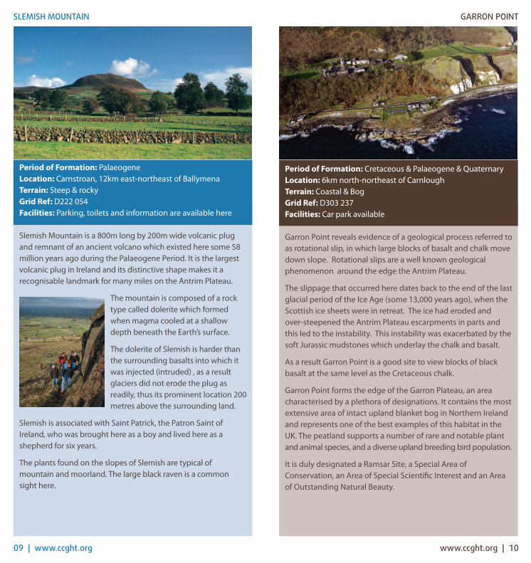
Period of Formation: Cretaceous & Palaeogene & QuaternaryLocation: 6km north-northeast of CarnloughTerrain: Coastal & Bog Grid Ref: D303 237Facilities: Car park available
Garron Point reveals evidence of a geological process referred toas rotational slip, in which large blocks of basalt and chalk movedown slope. Rotational slips are a well known geologicalphenomenon around the edge the Antrim Plateau.
The slippage that occurred here dates back to the end of the lastglacial period of the Ice Age (some 13,000 years ago), when theScottish ice sheets were in retreat. The ice had eroded and over-steepened the Antrim Plateau escarpments in parts andthis led to the instability. This instability was exacerbated by thesoft Jurassic mudstones which underlay the chalk and basalt.
As a result Garron Point is a good site to view blocks of blackbasalt at the same level as the Cretaceous chalk.
Garron Point forms the edge of the Garron Plateau, an areacharacterised by a plethora of designations. It contains the mostextensive area of intact upland blanket bog in Northern Irelandand represents one of the best examples of this habitat in theUK. The peatland supports a number of rare and notable plantand animal species, and a diverse upland breeding bird population.
It is duly designated a Ramsar Site, a Special Area ofConservation, an Area of Special Scientific Interest and an Areaof Outstanding Natural Beauty.
GARRON POINT
09 | www.ccght.org www.ccght.org | 10
SLEMISH MOUNTAIN
Period of Formation: PalaeogeneLocation: Carnstroan, 12km east-northeast of BallymenaTerrain: Steep & rockyGrid Ref: D222 054Facilities: Parking, toilets and information are available here
Slemish Mountain is a 800m long by 200m wide volcanic plugand remnant of an ancient volcano which existed here some 58million years ago during the Palaeogene Period. It is the largestvolcanic plug in Ireland and its distinctive shape makes it arecognisable landmark for many miles on the Antrim Plateau.
The mountain is composed of a rocktype called dolerite which formedwhen magma cooled at a shallowdepth beneath the Earth’s surface.
The dolerite of Slemish is harder thanthe surrounding basalts into which itwas injected (intruded) , as a resultglaciers did not erode the plug asreadily, thus its prominent location 200metres above the surrounding land.
Slemish is associated with Saint Patrick, the Patron Saint ofIreland, who was brought here as a boy and lived here as ashepherd for six years.
The plants found on the slopes of Slemish are typical ofmountain and moorland. The large black raven is a commonsight here.

Period of Formation: PalaeogeneLocation: West of CushendallTerrain: Steep, uneven, unsuitable for walking Grid Ref: D194 268Facilities: No access/parking available. Long range viewsavailable from Causeway Coastal Route
Tievebulliagh is the prominent hill located 4km west ofCushendall of which glimpses can be seen from the coast road.
The Palaeogene volcanism that formed the Antrim Plateau tookplace between 62 and 58 million years ago and constituted twooutpourings of basalt lava flows separated by an interval ofdormancy. The climate during this interval was subtropical with high levels of rainfall which lead to the surface of thebasalts rotting to create a red soil known as laterite. When avolcanic vent later punched through this lateritic soil, the hotmagma caused it to bake, forming the unique and extremelyhard rock Porcellanite.
During the Neolithic (4000 to 2,500 BC) Tievebulliagh was thesite of a stone axe factory. The highly prized porcellanite axeswere traded across Ireland and Britain during this time.
Abundant flakes of porcellanite can be found amongst the looserock debris (scree) at the foot of Tievebulliagh and represent therough working or shaping of the tools produced here.Occurrences of this rock type are restricted in Ireland to thislocation and Brockley on Rathlin Island. A collection ofporcellanite artefacts, including the Malone Hoard, can be seenin the Ulster Museum in Belfast.
TIEVEBULLIAGH
11 | www.ccght.org www.ccght.org | 12
PORT OBE
Period of Formation: DevonianLocation: CushendallTerrain: CoastalGrid Ref: D245 272Facilities: Parking available at Harbour in Cushendall
Rocks along the Antrim Coast from Port Obe at Cushendall toCushendun form what is referred to in geological terms as theCross Slieve Group. These rocks are 350-400 million years old,associated with the Devonian Period.
Rocks on the shore of Port Obe display both mudstone &sandstone from this period and are known as the BallyaganFormation.
Ridges of uncommon purple-red sandstone, varying in grain size,protrude through beach deposits here.
In some places, the top of these ridgesis characterised by a thick bed of hardpale green mudstone, featuring largecracks filled with sand. These cracks,known as dessication cracks, areassociated with the intense heatassociated with the Devonian period,which hardened the rock. Thesecracks have filled with sedimentsubsequently washed over them.
The coarse, pink sandstone forming the cliffs on the north side of Port Obe are also part of the Ballyagan Formation.
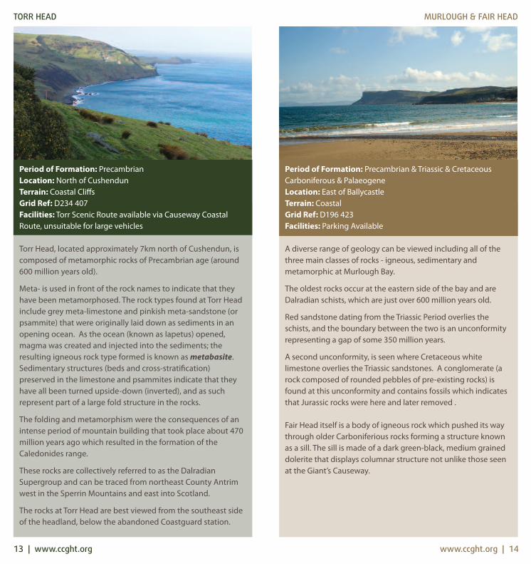
Period of Formation: Precambrian & Triassic & CretaceousCarboniferous & PalaeogeneLocation: East of BallycastleTerrain: Coastal Grid Ref: D196 423Facilities: Parking Available
A diverse range of geology can be viewed including all of thethree main classes of rocks - igneous, sedimentary andmetamorphic at Murlough Bay.
The oldest rocks occur at the eastern side of the bay and areDalradian schists, which are just over 600 million years old.
Red sandstone dating from the Triassic Period overlies theschists, and the boundary between the two is an unconformityrepresenting a gap of some 350 million years.
A second unconformity, is seen where Cretaceous whitelimestone overlies the Triassic sandstones. A conglomerate (arock composed of rounded pebbles of pre-existing rocks) isfound at this unconformity and contains fossils which indicatesthat Jurassic rocks were here and later removed .
Fair Head itself is a body of igneous rock which pushed its waythrough older Carboniferious rocks forming a structure knownas a sill. The sill is made of a dark green-black, medium graineddolerite that displays columnar structure not unlike those seenat the Giant’s Causeway.
MURLOUGH & FAIR HEAD
13 | www.ccght.org
TORR HEAD
Period of Formation: PrecambrianLocation: North of CushendunTerrain: Coastal CliffsGrid Ref: D234 407Facilities: Torr Scenic Route available via Causeway CoastalRoute, unsuitable for large vehicles
Torr Head, located approximately 7km north of Cushendun, iscomposed of metamorphic rocks of Precambrian age (around600 million years old).
Meta- is used in front of the rock names to indicate that theyhave been metamorphosed. The rock types found at Torr Headinclude grey meta-limestone and pinkish meta-sandstone (orpsammite) that were originally laid down as sediments in anopening ocean. As the ocean (known as Iapetus) opened,magma was created and injected into the sediments; theresulting igneous rock type formed is known as metabasite.Sedimentary structures (beds and cross-stratification)preserved in the limestone and psammites indicate that theyhave all been turned upside-down (inverted), and as suchrepresent part of a large fold structure in the rocks.
The folding and metamorphism were the consequences of anintense period of mountain building that took place about 470million years ago which resulted in the formation of theCaledonides range.
These rocks are collectively referred to as the DalradianSupergroup and can be traced from northeast County Antrimwest in the Sperrin Mountains and east into Scotland.
The rocks at Torr Head are best viewed from the southeast sideof the headland, below the abandoned Coastguard station.
www.ccght.org | 14

Period of Formation: Cretaceous & Palaeogene & QuaternaryLocation: Coastal Island, approx 9.5 miles from BallycastleTerrain: Coastal Grid Ref: D148 510Facilities: A regular ferry service runs between Ballycastle andRathlin weather permitting. Facilities available on the island
The geological structure of Rathlin Island, which can be viewedfrom the mainland, exhibits the startling contrast between theCretaceous white chalk and the overlying black Palaeogenebasalt.
A break in Palaeogene volcanic activity is recorded in theuppermost lava flows of the Lower Basalt Formation by theorange-red laterite preserved at various levels across the island.This deposit represents an ancient weathering that took placewhen rains and the subtropical conditions rotted the basaltlandscape surface.
This quiet period was interrupted by the eruption of lava flowsthat on the mainland formed the Giant’s Causeway. Theresulting rock formation (the Causeway Tholeiite Member) alsodisplays the famous columnar forms.
Rathlin also displays evidence of post-glacial sea-level changesand isostatic uplift. Both were due to the melting and retreat ofScottish ice. The melting initially raised sea-level, but this wasfollowed by the rise of the landscape due to it being unloadedof its ice (like taking the cargo off a ship) , the interaction ofthese processes created the platforms and raised beaches seenat various places around the island including Church Bay andRue Point.
RATHLIN ISLAND
15 | www.ccght.org www.ccght.org | 16
BALLYCASTLE
Period of Formation: Carboniferous & PalaeogeneLocation: BallycastleTerrain: CoastalGrid Ref: D136 417Facilities: Car-parking & facilities available in Ballycastle.
Ballycastle is one of the few places in Northern Ireland wheresedimentary rocks belonging to the upper part ofCarboniferous Period (also referred to as ‘the Coal Measures’)can be examined.
The rocks here are mainly sandstones and mudstones withabundant fossil plants and evidence of animal activity. Thesediments that formed these rocks were deposited in a delta toshallow marine setting. Vegetation was abundant on the deltaand built up into layers of peat that was later preserved asseams of coal.
The cliffs at Pans Rock have been designated as an Area ofSpecial Scientific Interest known as the Ballycastle Coalfield,and is the best exposure of a coalfield sequence in Ireland.Examples of the coal seams and abandoned adits are visible atMaguires Strand Caravan Park. Under no circumstances shouldthese mines be entered as they are highly dangerous due to instability.
Coal mining here dates back to the 13th Century and continueduntil the 1960’s. This area corresponds closely with theMachrihanism Coalfield in Kintyre, Scotland.

Period of Formation: Cretaceous Location: BallintoyTerrain: Coastal Grid Ref: D038 456Facilities: Car-parking, toilets and catering facilities available here
From Ballintoy Harbour west to Whitepark Bay, the shorelineconsists of metamorphosed chalk. This is the chalk laid down inmarine conditions during the Cretaceous which has been coveredwith and metamorphosed by the molten lava of the Palaeogene.
The Bendoo volcanic plug, a black igneous intrusion forms theheadland and this can be seen beside the old coastguard stationon the cliff-top, east of the Harbour.
A line of weakness in the earth exists here, known as theBallintoy Fault, which forms part of the larger Portbradden Fault.Erosion has occurred here and as a result of movement alongthis fault, the chalk exhibits a fractured appearance. This rocktype is known as rock breccia.
Large scale mining of the chalk occurred in this area and this industrylead to the establishment of the harbour here. Mining of the chalk isalso evidenced in the numerous lime kilns dotted around the areaincluding the kiln that can be seen at Ballintoy Harbour.
Ballintoy is notable for its well raised shoreline, its formationassociated with changes in sea level. During the last Ice Age,massive sheets of ice caused the land to sink here. Over time astemperatures rose and the ice sheets receded, this land slowlybegan to emerge, a process referred to as isostasy. The disusedquarry at Ballintoy Harbour Carpark shows a raised sea cave.
BALLINTOY HARBOUR
17 | www.ccght.org www.ccght.org | 18
CARRICKARADE
Period of Formation: PalaeogeneLocation: 2km east of BallintoyTerrain: CoastalGrid Ref: D061 449Facilities: : Car-parking, toilets and catering facilities available here
The island of Carrickarade and adjoining mainland reveal asection through a Palaeogene volcano which exploded heresome 62 million years ago.
The island is a volcanic plug composed of a dark green to black,medium-grain igneous rock known as dolerite. Once thefamous rope bridge has been crossed, the view back to themainland reveals large, angular, blocks of black Palaeogenebasalt, white Cretaceous chalk and grey Jurassic limestoneembedded in a sandy coloured volcanic ash. These deposits areknown as agglomerate and demonstrate the explosive natureof the volcano that formed them.
The chalk cliffs at Carrickarade host a raised sea cave which hasthe only known example of a speleotherm within the UlsterWhite Limestone. The speleotherm ,includes stalactites,stalagmites and a pillar and are thought to be a unique featurewithin the Cretaceous of Ireland and Britain.
The cliff-top habitats include maritime grassland, acid heathand chalk grassland. The site is home to two rare snails, thewrinkled snail and the heath snail, and breeding birds includetwites, kittiwakes, guillemots and razorbills.

Period of Formation: Palaeogene Location: Giants CausewayTerrain: Coastal Grid Ref: C945 440Facilities: Parking; public transport link & range of facilitiesavailable here
The Giant’s Causeway sits within a dynamic coastal landscape ofrugged cliffs, majestic headlands and secluded bays. It isdesignated a World Heritage Site by UNESCO in recognition of itsoutstanding geology and exceptional natural beauty.
Rocks that form the Giant’s Causeway date from the PalaeogenePeriod and are related to large scale volcanic activity whichprecluded the opening of the north Atlantic Ocean approximately55 million years ago.
The Causeway is made up of tens of thousands of basalt columnsthat together are referred to as the Causeway Tholeiite Member.The columns are preserved within lava flows that flooded a valleythat had become blocked – the result was a lava lake that cooledgradually but evenly. As the lava cooled it contracted and formedthe regular hexagonal shapes that we see today. The majority ofthe columns are five, six or seven sided with a few four and eightsided columns scattered around the site.
Occurring below the columnar basalts are a number of thinnerlava flows of the Lower Basalt Formation. The top of this rockformation was weathered due to the warm wet conditions duringa period of volcanic inactivity to form a deep orange-red materialknown as laterite.
Famous features to look out for include the Giant’s Organ, Eyesand Boot, and the Chimney Stacks.
GIANTS CAUSEWAY
19 | www.ccght.org www.ccght.org | 20
WHITE PARK BAY
Period of Formation: Jurassic & CretaceousLocation: Between Ballintoy & PortbraddenTerrain: CoastalGrid Ref: D001 440Facilities: Signposted from Causeway Coastal Route. Parking available adjacent to YHA Hostel
Rocks deposited during the Lower Jurassic Period (also known asthe Liassic or Lias) are present in Whitepark Bay. Towards theeastern side of the bay, during periods of low tide, grey mudstonesand limestones of the the Waterloo Mudstone Formation can beobserved. Marine fossils such as ammonites, belemnites andbivalves can be collected amongst the rocks here.
The younger, Cretaceous chalk is mainly exposed in the cliffsbehind the sand dunes and contain fossils such a belemnites,sea urchins and brachiopods.
The ground behind the beach anddunes is uneven because ofnumerous land-slipped blocks. Afterthe last glacial period when theScottish ice had retreated, the cliffshere were left in a seriously over-steepened state. This coupled withthe soft clay underlying the chalkcaused instability in this area.
The time interval between the last Liassic mudstone rocks andthe first Cretaceous rocks is over 100 million years. This gap inthe geological sequence is known as an unconformity.

Period of Formation: Cretaceous & Palaeogene Location: Between Portrush & PortballintraeTerrain: Coastal Grid Ref: C884 407Facilities: Parking & toilet facilities available here
The name White Rocks is derived from the magnificent whitechalk cliffs that date to the Cretaceous Period. A thick layer ofblack basalt caps this white chalk, evidence that lava flowed overthis area during the Palaeogene Period.
Numerous volcanic vents can be seen in the chalk cliffs at WhiteRocks. Agglomerate is a rock type that is found within thesevents,and is comprised of rounded and angular boulders of basaltand chalk reflecting the explosive nature of the volcano.
The vents in this area are thought to have formed due to theescape of gas and boiling fluids released by the formation of thePortrush sill, which intruded the Jurassic sediments present belowWhite Rocks.
Fossils in the chalk include brown, bullet-shaped belemnites, seaurchins and brachiopods.
To the east of White Rocks, Dunluce Castle is constructed onagglomerate. The unstable nature of the underlying geology atthis location may have led to the dramatic events reported in1639, when during a storm, the castle kitchens plunged into thesea below killing several staff.
WHITE ROCKS
21 | www.ccght.org www.ccght.org | 22
RUNKERRY STRAND
Period of Formation: Quaternary - recentLocation: PortballintraeTerrain: CoastalGrid Ref: C929 425Facilities: Parking & toilet facilities available besidePortballintrae Village Hall
The coastline at Runkerry Strand undergoes constant changeand absorbs more energy from waves than any other beach inNorthern Ireland. As a result of this, the beach demonstratesstrong seasonal variation. During adverse weather the beachcan be stripped of sand, and conversely, during fair weather,typical of summer months, the beach is fed material.
The River Bush, which enters the Bay at the southwest corner ofthe strand feeds the beach with terrestrial sediment, which iscrucial to balance out the material lost to the destructive wavesbattering the beach during the winter months.
A significant dune system backs thebeach and is thought to been formedin two different phases. Dunesshoreside of the tramline date back4000 years ago, while the older dunesbehind the tramline date back 5000 -6000 years.
The rapid rate of change at Runkerry Strand makes it an idealsite to study seasonal changes in the beach environment.

Period of Formation: Quaternary Location: MagilliganTerrain: Coastal Grid Ref: C662 392 Facilities: Parking available near entrance to Martello Tower.
Magilligan in the Binevenagh AONB is one of the largestcalcareous dune systems in the country. It is also noted for itsunmodified system of dune ridges and slacks and the greatnumber of dune grassland and dune slack plant communities.
The site also exhibits a record of Holocene sea-level changes thatoccurred as ice-sheets from the last glaciation receded. Floodingoccurred of the Lower Lough Foyle and material from a cliff, whichcan still be traced around the Lough, was transported. Gravelridges formed as a result of this process. As land levels rose withthe retraction of ice sheets and corresponding sea levels fell,lower volumes of water flowed in and out of the Lough.
When sea levels stabilised approximately 1500 years ago, sandsupply for ridge development was exhausted and erosion of theshoreline of Lough Foyle commenced until it stabilised to itscurrent position. This erosive phase released sand, which wasswept along coastline through long shore drift and sand droveashore formed the dune systems seen today. The dunes locatedalong the front reach a height of 17m in places.
Eastwards from Benone to Downhill, the coastline is relativelystable, however westwards the system is subject to significanterosion, up to 3 metres a year. The Magilligan system is the mostintensively studied coastal accumulation site in Ireland andamongst the top such localities in Europe.
MAGILLIGAN POINT
23 | www.ccght.org www.ccght.org | 24
RAMORE HEAD
Period of Formation: Palaeogene & JurassicLocation: PortrushTerrain: CoastalGrid Ref: C855 413Facilities: Various parking & facilities available in Portrush
Portrush is built upon a large body of Palaeogene igneous rock,which was intruded into older Jurassic rocks as magma. Such abody is referred to as a sill, and the Portush example is one ofthe thickest in Northern Ireland.
This is an internationally important locality in the history ofgeological study, as it caused much debate during the 18thcentury between two schools - the Neptunists and theVulcanists. Neptunists believed that basalt precipitated out ofsea water, whilst vulcanists believed that it was the result ofvolcanic activity.
The occurrence of ammonites, in what Nepunists believed wasbasalt, supported their theory. However, the Vulcanists wereable to show that although these rock closely resembled basalt,they were in fact sedimentary rocks, which as a result of theheat from molten lava, had been baked and metamorphosedinto a different rock type, known as hornfels.
The Skerries are a chain of small islands, 2km offshore andrepresent a continuation of the Portrush sill. Given thedistribution of the islands and exposed rocks onshore the sillcan be shown to be elliptical in shape.
Agglomerate: A rock type formed from a combination offragments of debris produced from explosive volcanic activity.
Ammonite: A now extinct marine animal that is related to themodern nautilus/squid.
Amphibian: A cold blooded vertebrate. The larvae live in waterand breathe using gills, the adults live on both land and waterand breathe using lungs.
Amygdaloidal Basalt: Bubble, or vesicles, in lava (in this casebasaltic lava) that have been filled with minerals.
Basalt: A volcanic igneous rock which is dark in colour, finegrained and basic in composition and which was originallyerupted as lava.
Belemnite: Belemnites (or belemnoids) are an extinct group ofmarine life, very similar in many ways to the modern squid
Bivalve: A class of marine and freshwater molluscs. Their shellconsists of two asymmetrically rounded halves known as valveswhich are mirror images of each other and joined by a hinge atone end.
Blanket Bog: An area of peatland which forms over a large areain conditions of high rainfall and low levels of evapotranspiration
Brachipod: Any of various marine invertebrates of the phylumBrachiopoda, having bivalve dorsal and ventral shells enclosing apair of tentacled, armlike structures that are used to sweepminute food particles into the mouth. Also called lampshell.
Breccia: A breccia that was formed due to tectonic processes. It is an unconsolidated rock composed of broken, fragmented rocks.
Calcareous: Mostly or partly composed of calcium carbonate.
Carboniferous: Geological time period extending from 354million years ago to 290 million years ago.
Chalk: A soft, white, porous sedimentary rock - a form oflimestone that is composed of the mineral calcite (calciumcarbonate). It forms in deep marine conditions as a result of thebuild up of the shells of microorganisms known as coccoliths.
Clay: A naturally occurring material that is very fine grained andforms due to long periods of chemical weathering of silicatebearing rocks.
Coccolith: A microscopic marine algae with a calcareous outer shell.
Conglomerate: A sedimentary rock which is made up offragments which range in shape and size.
Cretaceous: Geological time period after the Jurassic but beforethe Palaeogene, from approximately 142 million years ago to 65million years ago.
Crinoid: Also known as "sea lilies" or "feather-stars", are marineanimals that make up the class Crinoidea of the echinoderms(phylum Echinodermata). They live both in shallow water and indepths as great as 6000 meters. Crinoids are characterized by amouth on the top surface that is surrounded by feeding arms.
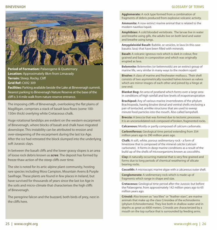
BINEVENAGH GLOSSARY OF TERMS
25 | www.ccght.org www.ccght.org | 26
Period of Formation: Palaeogene & QuaternaryLocation: Approximately 8km from LimavadyTerrain: Steep, Rocky, CliffGrid Ref: C692 309Facilities: Parking available beside the Lake at Binevenagh summit.Nearest parking to Binevenagh Nature Reserve at the base of thecliff is 3-4 mile walk from nature reserve entrance.
The imposing cliffs of Binevenagh, overlooking the flat plains ofMagilligan, comprises a stack of basalt lava flows (some 100-150m thick) overlying white Cretaceous chalk.
Huge rotational landslips are evident on the western escarpmentof Binevenagh, where blocks of basalt and chalk have migrateddownslope. This instability can be attributed to erosion and over-steepening of the escarpment during the last Ice Age. After the ice had retreated the block slumped into the underlyingsoft Jurassic clays.
In between the basalt cliffs and the lower grassy slopes is an areaof loose rock debris known as scree. The deposit has formed byfreeze thaw action of the steep cliffs over time.
The site is noted for its artic-alpine plant community, hosting rare species including Moss Campion, Mountain Avens & PurpleSaxifrage. These plants are found in few places in Ireland, buthave survived for thousands of years since the last Ice Age in the soils and micro-climate that characterises the high cliffs of Binevenagh.
The peregrine falcon and the buzzard, both birds of prey, nest inthe cliffs here.
Dalradian: A term that represents metamorphic rocks associatedwith the opening and closing of the Iapetus Ocean. They aremostly from 600 – 420 million years ago.
Desiccation cracks: A feature that form as a result of drying out.They confirm environments which are hot and arid thatexperience periodic rainfall followed by periods of drying out.
Devonian: Period of geological time extending from 417 millionyears ago to 354 million years ago. The Carboniferous is the timeperiod after and the Silurian the time period before.
Dolerite: An igneous rock which is dark in colour, mediumgrained and basic in composition. It has the same composition asbasalt only coarser crystals due to the rate of cooling.
Dune Ridges: In areas of large-scale dune activity, certain typesof dunes result in sand ridges
Dune Slacks: Low-lying depressions within a dune system
Fault: A planar fracture within a volume of rock over whichsignificant movement can occur. It is a line of weakness thatforms due to tectonic processes.
Flint: A rock type composed of microscopic crystalline silica. Itforms nodules within the Cretaceous Chalk
Fold/Folding: A deformation process that results deep within theEarth, at high temperatures and pressures. It results in rocks thatappear to have been bent.
Freeze-Thaw Action: A type of weathering process that operateswhen the temperature is around the freezing point of water. Itoperates on the basis that water contracts when it thaws andexpands when it freezes resulting in a change in volume.Therefore water in pore spaces or fractures in rocks causes themto weaken and ultimately to break up.
Hibernian Greensands Formation: A division of the Cretaceousrocks in Northern Ireland. This formation is restricted to the southand eastern fringes of the Antrim Plateau.
Holocene: Geological epoch within the Quaternary period. Itencompasses the last 10,000 years.
Hornfels: A name of a group of contact metamorphosed rocksthat have been baked by the heat of an igneous intrusion. Theyare usually very hard and fine grained rocks.
Isostasy: Describes the process that occurs when temperaturesrise and ice melts the weight of the ice is removed from thesurface of the Earth causing the Earth’s crust to gradually rise up;this is the process of isostasy.
Jurassic: Period of the stratigraphical column fromapproximately 206 million years ago to 142 million years ago.
Laterite: A weathering product, commonly igneous rocks.Generally occurs in wet tropical conditions and produces areddy/brown sediment
Liassic/Lias:Term used in defining the lower part of the Jurassic Period.It is characterised by grey clays and mudstones in northeast of Ireland.
GLOSSARY OF TERMS
Limestone: A sedimentary rock composed mainly of calciumcarbonate in the form of the mineral calcite.
Lower Basalts: The term given to the first series of lavas thatflowed across the region some 62 – 60 million years ago duringthe Palaeogene Period.
Magma: Molten rock that, when cooled, forms an igneous rock.Magma that extrudes onto the surface is termed lava and magmathat intruded below the surface and solidifies there formsintrusive igneous rocks.
Marine Transgression: A geological event whereby sea levelsrise relative to the land surface causing the shoreline to move tohigher ground.
Mercia Mudstone Group: A sequence of sedimentary rocks thatoccurs widely across Britain and Ireland. It consists of mudstones,siltstones and sandstones and is Triassic in age.
Metabasite: A collective term, for metamorphosed rock that haslost all traces of its original texture and mineralogy owing tocomplete recrystallization.
Metamorphism: This process is the recrystallization of pre-existing rocks due to changes in physical and chemicalconditions, primarily heat, pressure, and the introduction ofchemically active fluids
Mudstone: A sedimentary rock composed of clay size particles. It is structureless and unlaminated.
Neolithic: Prehistoric period related to the Stone Age beginningaround 4500 B.C. characterized by the development ofagriculture and the making of polished stone implements
Neptunist/Neptunism: A discredited scientific theory whichdates back to the 18th Century which proposed that rocks formedfrom the crystallisation of minerals in the earth’s oceans.
Olivine Basalt: A type of basalt that has an abundance of themineral olivine. Olivine is a yellow-green magnesium iron silicatemineral.
Palaeogene: Geological time period extending from 65 millionyears ago to 23 million years ago.
Penarth Group: A formation of rocks deposited over a period ofapproximately 4 million years associated with the close of theTriassic period.
Porcellanite: So called due to its fine-grain blue appearance thatlooks like porcelain. It forms by the heating of weathered basalt(laterite). The heat comes from the neighbouring volcanic plug.
Psammite: A medium grained metamorphic rock that wasoriginally sandstone.
Pyroclastic: A volcanic rock fragment/deposit that is ejected intothe air during a volcanic eruption.
Quaternary: Period of the stratigraphical column extending fromapproximately 2.6 million years ago to the present.
GLOSSARY OF TERMS
27 | www.ccght.org www.ccght.org | 28
Raised Beaches: Coastal beaches and other formations such ascliffs and caves that are above the present shore line. Theyformed after the Ice Age when the sea level was higher due tomelting of the ice.
Ramsar Site: Wetland sites of international importancedesignated under the Ramsar Convention
Rotational Slip: The slipping of a rock unit along a curved planeon a decline.
Sandstone: A sedimentary rock composed of cemented sandgrains. Its grain size can vary.
Schists: A metamorphic rock which has been subjected to hightemperatures and pressures deep within the earth. It ischaracterised by its shiny appearance due to the formation ofsecondary mica.
Scree: Accumulation of broken rock fragments on a slope.
Sill: Horizontal (or near horizontal) body of igneous rock that hasbeen intruded into older sediments in which it lies conformably.
Speleotherm: Formations that commonly form in limestone caves
Tombolo: A bar that extends outward from the shore, connectingwith an island.
Triassic: Time period extending from 248 million years ago to206 million years ago.
Unconformity: A surface of erosion or non-deposition thatseparates younger rocks from older rocks. It represents thepassage of time.
Upper Basalts: The termed given to the second cycle of lavasthat flowed across the region during the Palaeogene 65 millionyears ago to 23 million years ago.
Volcanic Cone: Created by eruptions that throw out mostly smallpieces of rock that build up around the vent. These can berelatively short-lived eruptions that produce a cone-shaped hill
Volcanic Plug: A volcanic landform formed when magmahardens within a volcanic vent of an active volcano.
Volcanic Vent: A volcanic opening, sometimes a pipe, which canoften be filled with fragmental material.
Waterloo Mudstone Formation: Also known as Lias Clay, it wasdeposited in the Jurassic approximately 200 million years ago.
World Heritage Site: A UNESCO World Heritage Site is a place(such as a forest, mountain, lake, desert, monument, building,complex, or city) that is listed by the UNESCO as of special culturalor physical significance.
Zeolite: A mineral with a porous structure, formed wherevolcanic rocks and ash layers react with alkaline groundwater
GLOSSARY OF TERMSAbbreviations
AONB: Area of Outstanding Natural Beauty ASSI: Area of Special Scientific Interest SPA: Special Protection AreaSAC: Special Area of ConservationNNR: National Nature ReserveWHS: World Heritage Site
References
A Geological Excursion Guide to the Causeway Coast - Paul Lyle (EHS) 2ND Edition 2005
A Story Through Time - Patrick McKeever (1991)
The Classic Geology of the North of Ireland - Ian Mitchell, Mark Cooper, Patrick McKeever & Brian McConnell (2010)
The Geology of Northern Ireland: Our Natural Foundation -Geological Survey of Northern Ireland (2004)
The North of Ireland – Classic Geology in Europe- Paul Lyle (2003)
www.doeni.gov.uk/niea/biodiversity
www.doeni.gov.uk/niea/landscape
www.habitas.org
Acknowledgements
This publication has been produced by the Causeway Coast &Glens Heritage Trust with the financial assistance of the RuralDevelopment Programme, Northern Ireland EnvironmentalAgency and the Northern Ireland Tourist Board.
Special thanks to Mark Cooper & Patrick McKeever, Geological SurveyNorthern Ireland for their invaluable assistance with this project.
The CCGHT provides a secretariat service to the Antrim Coast &Glens, Causeway Coast & Binevenagh AONB ManagementGroups. The Trust is grateful for support from the NorthernIreland Environmental Agency an agency with the Department ofthe Environment, Northern Ireland Tourist Board, Moyle DistrictCouncil; Coleraine Borough Council, Limavady Borough Council,Larne Borough Council & Ballymena Borough Council.
Photo Credits:Ballymena Borough Council; Geological Survey Northern Ireland;Limavady Borough Council; Mike Hartwell; Northern IrelandEnvironmental Agency; Northern Ireland Tourist Board & UlsterMuseum.
For information on the work of the Causeway Coast & GlensHeritage Trust please contact the staff at the following address:Tilly Molloys 18 Main Street, Armoy, Antrim BT 53 8RQ.Tel: (028) 20752100 Fax: (028) 20752101Or visit our website www.ccght.orgDesign by: www.thinkstudio.co.uk
REFERENCES & ACKNOWLEDGEMENTS
29 | www.ccght.org www.ccght.org | 30