road safety audit report
TRANSCRIPT
ROAD SAFETY AUDIT
Route 6 (Scenic Highway)
Town of Bourne
March 3, 2014
Prepared For:
MassDOT Highway Division
Prepared By:
BETA Group, Inc.

Road Safety Audit—Route 6 (Scenic Highway)—Bourne, MA Prepared by BETA Group, Inc.
Table of Contents
Project Data ................................................................................................................................. 1
Background ................................................................................................................................. 2
Project Description ..................................................................................................................... 2
Audit Observations ..................................................................................................................... 6
Potential Safety Enhancements ................................................................................................. 8
Summary of Road Safety Audit ................................................................................................. 9
List of Appendices
Appendix A. RSA Meeting Agenda
Appendix B. RSA Audit Team Contact List
Appendix C. Detailed Crash Data
Appendix D. Speed Regulations
List of Figures
Figure 1. Location Map ......................................................................................................................... 3
Figure 2. Location Detail ....................................................................................................................... 6
List of Tables
Table 1. Participating Audit Team Members ....................................................................................... 1
Table 2. Estimated Time Frame and Costs Breakdown ....................................................................... 8
Table 3. Potential Safety Enhancement Summary ............................................................................. 10
Road Safety Audit—Route 6 (Scenic Highway)—Bourne, MA Prepared by BETA Group, Inc.
Page 1
Project Data
A Road Safety Audit for Route 6 (Scenic Highway) between Route 25 and Route 3 was held on February
11, 2014 at Bourne Town Hall in Buzzards Bay, MA. As indicated in Table 1, the audit team consisted of
representatives from State, Regional and Local agencies and included a cross-section of engineering,
planning and emergency response expertise.
Table 1. Participating Audit Team Members Audit Team Member Agency/Affiliation
Corey O’Connor MassDOT Highway Division – Safety Section
Pamela Haznar MassDOT Highway Division – District 5
Sgt. James Czyryca Bourne Police
Barbara LaChance MassDOT Highway Division – District 5 Traffic Ops
Edward C. Feeney MassDOT Highway Division – District 5 Traffic Ops
Jason Walters MassDOT Highway Division – District 5 Projects
Jon Nelson Town of Bourne
George Sala Town of Bourne DPW
Greg Lucas BETA Group, Inc.
Justin Curewitz BETA Group, Inc.
Road Safety Audit—Route 6 (Scenic Highway)—Bourne, MA Prepared by BETA Group, Inc.
Page 2
Background
The Federal Highway Administration defines a Road Safety Audit (RSA) as the formal safety examination
of an existing or future road or intersection by an independent, multidisciplinary team. The purpose of an
RSA is to identify potential safety issues and possible opportunities for safety improvements considering
all roadway users. A Road Safety Audit was scheduled for Route 6 (Scenic Highway) between Route 25
and Route 3 because the corridor has experienced a significant number of crashes. A project is under
development to add shoulders and a center median to the segment of Route 6 between Nightingale Pond
Road and Edge Hill Road (MassDOT File No. 606082). The RSA is intended to identify potential short
and long term safety improvements that can be made along the corridor, which can then be implemented
through general maintenance for short term low cost improvements or incorporated into the planned
reconstruction project for long term improvements.
Project Description
Route 6 (Scenic Highway) serves a significant role as a regional connector to and from Cape Cod. The
segment of Route 6 between Route 25 and Route 3 runs parallel to the mainland side of the Cape Cod
Canal. Route 25 provides freeway access from the ends of both I-195 and I-495 to the Bourne Bridge,
while Route 3 provides freeway access from the South Shore and metro Boston to the Sagamore Bridge.
Route 3 has an interchange before the Sagamore Bridge with Route 6, which continues across the bridge
and along Cape Cod as a freeway known as the Mid-Cape Highway.
The study segment of Route 6, shown in Figure 1, is functionally classified as a Principal Arterial and is
under MassDOT jurisdiction. Route 6 is signed as an east-west roadway, but follows a southwest-
northeast alignment through the study area, following the alignment of the Cape Cod Canal. All other
intersecting freeways (Route 25, Route 3, and Route 6 Mid-Cape Highway) are also functionally
classified as Principal Arterials under MassDOT jurisdiction. The Bourne Bridge and Sagamore Bridge
are under the jurisdiction of the Army Corps of Engineers.
Route 6 generally provides two lanes in each direction within the study area. The western end of the study
area is the elongated rotary intersection with the ramps to and from Routes 25 and 28. Route 6 is median
divided from the rotary to a signalized intersection with Nightingale Pond Road approximately ¼ mile
east of the rotary. A Hess gas station with a Dunkin’ Donuts is located on the north side of Route 6 in this
segment, but is restricted to right-in/right-out access from Route 6 westbound due to the center median.
Sidewalks are provided on both sides of Route 6 between Route 25 and Nightingale Pond Road. A solid
white edge line with a minimal edge offset is provided in both directions. The signalized intersection of
Route 6 and Nightingale Pond Road is a 4-way intersection with Nightingale Pond Road forming the
north leg and a campground access road forming the south leg. Nightingale Pond Road provides a two-
lane approach with a shared lane for left turns and through vehicles and an exclusive right turn lane. No
left turn lanes are provided on Route 6; left turns to Nightingale Pond Road or the campground are
accommodated from shared lanes. A crosswalk is provided across the west leg of Route 6 with
pushbuttons activating an exclusive pedestrian phase.

Road Safety AuditRoute 6 Scenic Highway
Bourne, MA
Figure 1
Location Map
LEGEND
CAPE
COD
CANA
L
ROUTE25
ROUTE 6 SCENICHIGHWAY
SAND
WIC
HRO
AD
RO
UTE
6
NIGH
TING
ALE
POND
ROAD
STUDY CORRIDOR
EDGE HILL ROAD
BOURNEDALE ROAD
Road Safety Audit—Route 6 (Scenic Highway)—Bourne, MA Prepared by BETA Group, Inc.
Page 3
Figure 1. Location Map

Road Safety Audit—Route 6 (Scenic Highway)—Bourne, MA Prepared by BETA Group, Inc.
Page 4
Route 6 Westbound at Edge Hill Road
Route 6 continues east approximately 1.4 miles to a signalized intersection with Edge Hill Road. This
segment of Route 6 continues to provide two travel lanes in each direction, and is undivided except for a
median on the approach to Edge Hill Road. Shoulders of varying width are provided along this segment,
but no sidewalks are provided. The topography of the area generally slopes towards the canal, which
creates upward slopes on the north side of the roadway and guardrail along a downward slope on the
south (canal) side of the roadway. A sweeping horizontal curve to the right accompanies a downhill grade
for westbound drivers in this segment. A history of crashes on wet roadway surfaces led to resurfacing
and drainage improvements in this area.
A reconstruction project at the intersection of Edge Hill Road included installation of the traffic signal
and construction of an eastbound left turn lane and medians on the intersection approaches. Edge Hill
Road approaches Route 6 from the north, and provides separate lanes for left and right turns. Edge Hill
Road and Nightingale Pond Road both provide access to an otherwise isolated residential neighborhood
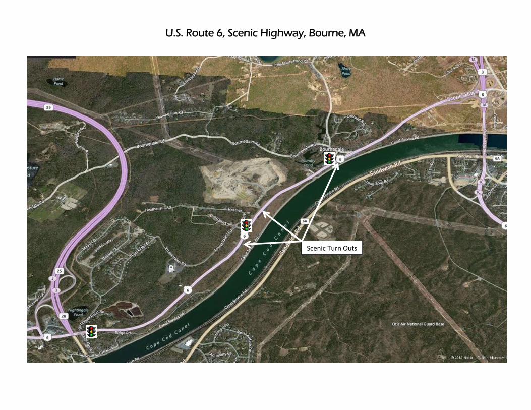
and to Bournedale Elementary School. Scenic turn-outs are provided along the south side of Route 6 on
both sides of Edge Hill Road; medians extending from the intersection prevent turns into either turn-out
from Route 6 westbound. Oversized Signal Ahead warning signs are provided in advance of Edge Hill
Road in both directions, supplemented by flashing beacons.
The median dividing the east leg of Route 6 at Edge Hill Road extends approximately 800 feet from the
intersection. Route 6 is undivided from the end of this median to the signalized intersection at Bournedale
Road. A driveway to a gravel plant intersects Route 6 just beyond the end of the median; trucks typically
follow right-in right-out operation, although left turns to and from the driveway are legally allowed.
Route 6 between Edge Hill Road and Bournedale Road continues to provide two lanes in each direction,
with shoulders of varying width and no sidewalks. Businesses and minor side streets on the north side of
Route 6 approaching Bournedale Road have access from both directions of Route 6. Route 6 eastbound
approaching Bournedale Road provides two through lanes, an exclusive left turn lane to Bournedale
Road, and a right turn lane to a scenic turn out adjacent to the Herring Run Recreation Area. Route 6
westbound provides a left turn lane to the scenic turn out parking area, and two through lanes. This scenic
parking area adjacent to Herring Run Recreation Area is the only one within the study area accessible
from Route 6 westbound. Herring Pond Road intersects Route 6 approximately 750 feet to the east of

Road Safety Audit—Route 6 (Scenic Highway)—Bourne, MA Prepared by BETA Group, Inc.
Page 5
Route 6 Eastbound at Bournedale Road
Bournedale Road and forms a triangle with Bournedale Road and Route 6; traffic from Route 6 west uses
Herring Pond Road to access Bournedale Road rather that turning right at the signalized intersection.
Bournedale Road at the signal has a wide approach lane which separates into left and right turning lanes,
separated by a triangular island. Crosswalks are provided across the west leg of Route 6 allowing a
pedestrian connection to Herring Run Recreation Area, and across Bournedale Road. A sidewalk is
provided along the north side of Route 6 between Bournedale Road and Herring Pond Road. Illuminated
RED Signal Ahead signs are provided in both directions, although only the eastbound sign is mounted
overhead. It was noted that the westbound sign was ground-mounted due to wind load concerns.
A median begins just to the west of Herring Pond Road, prohibiting left turns onto Route 6 eastbound
from Herring Pond Road. This median continues along Route 6 from Herring Pond Road through the
series of ramps and signalized intersections connecting this segment of Route 6 with Route 3 and the
Sagamore Bridge. The ramp carrying Route 6 eastbound to the Sagamore Bridge is approximately ¾ mile
east of Herring Pond Road and forms the eastern end of the study area. Route 6 eastbound widens to
provide a deceleration area for the ramp, and continues to provide two through lanes east of the ramp.
Crash data provided by both State and local police and summarized by MassDOT show 31 crashes within
the study area from January 2009 to June 2012. A crash summary is included in the Appendix. The most
prevalent crash type are single vehicle crashes, comprising 55% of all crashes. Sixteen of 31 crashes were
noted to involve a hydroplaning vehicle, and 74% of crashes involved wet or snowy roadways. It was
noted that vehicles hydroplane on the downhill grade and horizontal curve westbound between Edge Hill
Road and Nightingale Pond Road, and that vehicles end up encroaching on the eastbound lanes or striking
the guardrail bordering the south side of the roadway. Wet roadway crashes have continued in the wake of
recent drainage and resurfacing improvements.
Speed regulation information was provided for Route 6 in Bourne. The speed regulation for the study area
was updated in 2006 and establishes a signed 50 mph zone generally between Nightingale Pond Road and
Bournedale Road. The established, posted speed limit reduces to 40 mph in the vicinity of the Route 3
and Route 6 ramps at the eastern end of the study area, and reduces to 35 mph west of Nightingale Pond
Road at the western end of the study area. The westbound speed limit further reduces to 25 mph
approaching the elongated rotary at Routes 25 and 28.

Road Safety Audit—Route 6 (Scenic Highway)—Bourne, MA Prepared by BETA Group, Inc.
Page 6
Audit Observations
Following a brief introduction to the RSA process and a summary of existing crash information, the audit
participants were asked to discuss safety issues for Route 6 (Scenic Highway). Audit participants viewed
a video recording of the corridor, and subsequently offered observations on safety issues. A summary of
those major safety considerations is as follows:
Hydroplaning – Hydroplaning is of significant concern along Route 6, as evidenced by the history of
crashes on wet pavement. The area of concern is shown in Figure 2. A number of contributing factors
were identified.
o Pavement Rutting – Route 6 was recently resurfaced in this area, but heavy truck traffic along
the corridor results in visible ruts, especially along the outside lanes. Pavement rutting can create
ponding channels, which increase the potential for hydroplaning when braking.
o Sheet Flow and Superelevation – It was noted that the westbound downhill slope approaching
Nightingale Pond Road results in significant sheet flow, and that this flow then stays within the
westbound lanes due to the superelevation. This sheet flow in the westbound lanes can promote
hydroplaning across the roadway.
o Ponding – The superelevation contains the water within the westbound lanes through the
horizontal curve shown in Figure 2, which then results in ponding during heavy rain events in
the westbound shoulder. Recent drainage improvements included additional catch basins in this
area, but ponding still occurs where basins are not present.
Figure 2. Location Detail
AREA OF
CONCERN

Road Safety Audit—Route 6 (Scenic Highway)—Bourne, MA Prepared by BETA Group, Inc.
Page 7
Damaged Guardrail along Route 6 eastbound
Speed – Driver speed along Route 6 was noted as a safety concern, and a contributing factor in wet
roadway crashes. Nine of 31 crashes cited “driving too fast for conditions”. The downhill grade of
Route 6 westbound approaching the curve before Nightingale Pond Road encourages driver speed,
and may cause a driver to brake to slow the vehicle, initiating hydroplaning
Lack of Shoulders – The lack of usable shoulders along Route 6 between Nightingale Pond Road and
Edge Hill Road was cited as a safety concern. The lack of shoulders reduces the amount of time that a
driver has to correct an errant maneuver. The guardrail along the eastbound lanes shows extensive
evidence of vehicle strikes, likely from westbound vehicles traveling across the eastbound lanes and
the limited shoulder available.
Red Signal Ahead Sign –The Red Signal Ahead sign for Route 6 westbound in advance of
Bournedale Road is ground mounted, reducing its visibility and effectiveness. It was noted that this
sign was post-mounted rather than overhead mounted due to concerns over wind loading.

Road Safety Audit—Route 6 (Scenic Highway)—Bourne, MA Prepared by BETA Group, Inc.
Page 8
Potential Safety Enhancements
After viewing the video recording of the corridor, audit participants were asked to discuss the safety
issues and consider improvements. Audit participants were encouraged to consider both short and long
term improvements for each issue. Each improvement considered has been categorized as short-term,
mid-term, or long-term based on the definitions shown in Table 2. Additionally, a cost category has been
assigned to each improvement based on the parameters set forth in Table 2.
Table 2. Estimated Time Frame and Costs Breakdown Time Frame Costs
Short-term <1 year Low <$10,000
Mid-term 1–3 years Medium $10,000–$50,000
Long-term >3 years High >$50,000
Widen shoulders between Nightingale Pond Road and Edge Hill Road. It was noted that the planned
project will widen this segment of Route 6 and provide 4 foot minimum width shoulders. This is a
long-term, high cost improvement. It should be noted that a recent MassDOT directive requires 5 foot
minimum width shoulders for bicycle accommodation. The audit team discussed the need for bicycle
accommodation along Route 6, given the presence of the Cape Cod Canal Bikeway, which runs along
the canal parallel to Route 6. It was determined that despite the adjacent bike path, bicycle
accommodation should be provided along Route 6 if bicycles are legally allowed on the roadway.
Provide a center median between Nightingale Pond Road and Edge Hill Road. A center median is
proposed as part of the planned project, and would provide a continuous median from the rotary at the
Route 25 ramps to east of Edge Hill Road, with breaks only at the signalized intersections of
Nightingale Pond Road and Edge Hill Road. The median will break up sheet flow of stormwater, but
will require additional catch basins along the median edge. This is a long-term, high cost
improvement.
Provide proper superelevation through the horizontal curve between Nightingale Pond Road and Edge
Hill Road. Superelevation rates should meet AASHTO and MassDOT guidelines. Modifications to
existing cross slopes may require additional changes to drainage, in addition to those changes
required by median construction. This is a long-term, high cost improvement.
Construct drainage channels or swales on the north side of Route 6. Drainage swales in the area of
ponding concern would process stormwater and prevent ponding on the road. This is a long term,
high cost improvement.
Consider high friction pavement and subsurface investigation as part of pavement reconstruction
strategies. It was noted that the current project concept proposes resurfacing of Route 6 between
Nightingale Pond Road and Edge Hill Road, which will address current pavement rutting concerns. It
was suggested that further subsurface investigation should be conducted to determine if full depth
pavement reconstruction is required for all or part of the project segment, and that high friction
Road Safety Audit—Route 6 (Scenic Highway)—Bourne, MA Prepared by BETA Group, Inc.
Page 9
pavement may be appropriate for the downhill segment due to the heavy truck traffic along the
corridor. This is a long-term, potentially high cost improvement.
Continue speed enforcement along the corridor. This is a short-term and ongoing measure, the cost of
which is reduced enforcement elsewhere.
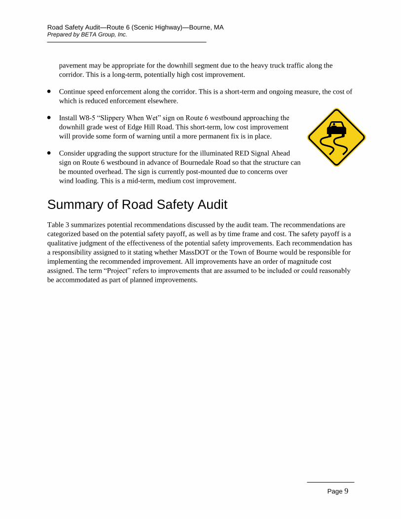
Install W8-5 “Slippery When Wet” sign on Route 6 westbound approaching the
downhill grade west of Edge Hill Road. This short-term, low cost improvement
will provide some form of warning until a more permanent fix is in place.
Consider upgrading the support structure for the illuminated RED Signal Ahead
sign on Route 6 westbound in advance of Bournedale Road so that the structure can
be mounted overhead. The sign is currently post-mounted due to concerns over
wind loading. This is a mid-term, medium cost improvement.
Summary of Road Safety Audit
Table 3 summarizes potential recommendations discussed by the audit team. The recommendations are
categorized based on the potential safety payoff, as well as by time frame and cost. The safety payoff is a
qualitative judgment of the effectiveness of the potential safety improvements. Each recommendation has
a responsibility assigned to it stating whether MassDOT or the Town of Bourne would be responsible for
implementing the recommended improvement. All improvements have an order of magnitude cost
assigned. The term “Project” refers to improvements that are assumed to be included or could reasonably
be accommodated as part of planned improvements.

Road Safety Audit—Route 6 (Scenic Highway)—Bourne, MA Prepared by BETA Group, Inc.
Page 10
Table 3. Potential Safety Enhancement Summary
Safety Issue Safety Enhancement Responsibility Safety Payoff
Time Frame
Cost
Lack of Shoulders Widen shoulders between Nightingale Pond Road and Edge Hill Road. 5 foot shoulders are recommended if bicycle accommodation is required.
MassDOT High Long-term High*
Hydroplaning, Sheet Flow
Provide a center median between Nightingale Pond Road and Edge Hill Road.
MassDOT High Long-term High*
Hydroplaning, Sheet Flow and Superelevation
Provide proper superelevation through the horizontal curve between Nightingale Pond Road and Edge Hill Road. This may require modifications to existing drainage.
MassDOT Medium Long-term High*
Ponding Construct drainage channels or swales on the north side of Route 6. MassDOT Medium Long-term High*
Pavement Rutting Consider high friction pavement and subsurface investigation as part of pavement reconstruction strategies.
MassDOT Medium Long-term High*
Speed Continue speed enforcement along the corridor. State/Town
Police Medium Short-term
$0 (Reduced
enforcement elsewhere)
Hydroplaning Install W8-5 “Slippery When Wet” sign on Route 6 westbound approaching the downhill grade west of Edge Hill Road.
MassDOT Low Short-term $300
Red Signal Ahead Sign
Consider upgrading the support structure for the illuminated RED Signal Ahead sign on Route 6 westbound in advance of Bournedale Road so that the structure can be mounted overhead.
MassDOT Low Mid-term $25,000
* Improvements to be incorporated into the proposed project are assumed to be included as part of the overall project cost.

Road Safety Audit—Route 6 (Scenic Highway)—Bourne, MA Prepared by BETA Group, Inc.
Appendix A. RSA Meeting Agenda

Road Safety Audit Bourne, MA
Route 6, Scenic Highway Meeting Location: Bourne Town Hall 24 Perry Avenue Buzzard’s Bay, MA
Tuesday, February 11, 2014 1:00 PM – 3:00 PM
Type of meeting: High Crash Location – Road Safety Audit Attendees: Invited Participants to Comprise a Multidisciplinary Team Please bring: Thoughts and Enthusiasm!!
1:00 PM Welcome and Introductions
1:15 PM Discussion of Safety Issues
• Crash history, Speed Regulations – provided in advance
• Existing Geometries and Conditions
2:00 PM View Video Footage and Site Visit (if necessary) • View video of Route 6 (Scenic Highway) and, if necessary, drive to a specific
location along Route 6.
• As a group, identify areas for improvement
2:30 PM Discussion of Potential Improvements • Discuss observations and finalize safety issue areas
• Discuss potential improvements and finalize recommendations
3:00 PM Adjourn for the Day – but the RSA has not ended
Instructions for Participants:
• Before attending the RSA on February 11th, participants are encouraged to drive/walk through the intersection and complete/consider elements on the RSA Prompt List with a focus on safety.
• All participants will be actively involved in the process throughout. Participants are encouraged to come with thoughts and ideas, but are reminded that the synergy that develops and respect for others’ opinions are key elements to the success of the overall RSA process.
• After the RSA meeting, participants will be asked to comment and respond to the document materials to assure it is reflective of the RSA completed by the multidisciplinary team.

Road Safety Audit—Route 6 (Scenic Highway)—Bourne, MA Prepared by BETA Group, Inc.
Appendix B. RSA Audit Team Contact List

Participating Audit Team Members Date: February 11, 2014 Location: Bourne – Route 6 Scenic Highway
Audit Team Member Agency/Affiliation Email Address Phone Number
Greg Lucas BETA [email protected] 781-255-1982
Justin Curewitz BETA [email protected] 781-255-1982
Corey O’Connor MassDOT – Safety [email protected] 857-368-9638
Pamela Haznar MassDOT D5 Projects [email protected] 508-884-4239
Sgt. James Czyryca Bourne Police [email protected] 508-759-4452
Barbara LaChance MassDOT D5 Traffic Ops [email protected] 508-884-4260
Edward C. Feeney MassDOT D5 Traffic Ops [email protected] 508-884-9242
Jason Walters MassDOT D5 [email protected] 508-884-4370
Jon Nelson Bourne DPW [email protected] 508-566-1349
George Sala Bourne DPW [email protected] 508-759-0640

Road Safety Audit—Route 6 (Scenic Highway)—Bourne, MA Prepared by BETA Group, Inc.
Appendix C. Detailed Crash Data
Scenic Turn Outs
U.S. Route 6, Scenic Highway, Bourne, MA
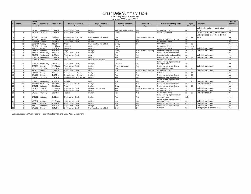
# Month #Crash Date Crash Day Time of Day Comments
Can it be located?
m/d/y Type Type Type Type Type D1 D2
1 1 1/7/09 Wednesday 1:31 PM Single Vehicle Crash Daylight Sleet, Hail, Freezing Rain Wet No Improper Driving 56Vehicle slid on ice. In construction zone. yes
2 3 3/19/09 Thursday 2:32 PM Single Vehicle Crash Daylight Cloudy Wet Visibility Obstructed 37 Visibility obstructed by heavy rainfall no
3 5 5/7/09 Thursday 4:48 AM Sideswipe, same direction Dark - roadway not lighted Rain Water (standing, moving) 41 71Vehicle hydroplaned. In construction zone. no
4 9 9/27/09 Sunday 12:04 PM Single Vehicle Crash Daylight Rain Wet Driving too fast for conditions 46 yes5 12 12/22/09 Tuesday 2:07 PM Single Vehicle Crash Daylight Clear Wet No Improper Driving 23 yes6 12 12/27/09 Sunday 5:29 PM Angle Dark - roadway not lighted Cloudy Dry Inattention 36 30 yes7 3 3/11/10 Thursday 11:15 AM Rear-end Daylight Cloudy Dry No Improper Driving 35 unk yes8 4 4/9/10 Friday 3:13 PM Rear-end Daylight Clear Dry Followed too closely 67 84 Vehicle hydroplaned yes9 7 7/24/10 Saturday 6:30 PM Angle Daylight Cloudy Water (standing, moving) Over-correcting/over-steering 30 28 Vehicle hydroplaned no
10 8 8/25/10 Wednesday 9:38 AM Single Vehicle Crash Daylight Rain Wet Driving too fast for conditions 52 yes11 10 10/6/10 Wednesday 6:37 AM Single Vehicle Crash Dawn Rain Wet Exceeded authorized speed limit 30 Vehicle hydroplaned yes12 11 11/17/10 Wednesday 7:29 AM Angle Daylight Rain Wet Driving too fast for conditions 36 37 Vehicle hydroplaned yes13 11 11/28/10 Sunday 7:15 PM Rear-end Dark - lighted roadway Unknown Dry Followed too closely 51 27 yes
14 12 12/8/10 Wednesday 10:30 AM Single Vehicle Crash Daylight Unknown DryFailure to keep in proper lane or running off road 22 no
15 2 2/25/11 Friday 11:09 AM Single Vehicle Crash Daylight Severe Crosswinds Wet Driving too fast for conditions 55 Vehicle hydroplaned no16 5 5/12/11 Thursday 7:30 AM Rear-end Daylight Clear Dry Other improper action 29 45 yes17 6 6/12/11 Sunday 7:27 AM Single Vehicle Crash Dawn Rain Water (standing, moving) No Improper Driving 24 Vehicle hydroplaned no18 7 7/22/11 Friday 6:00 AM Sideswipe, same direction Daylight Clear Dry Unknown 30 19 yes19 8 8/15/11 Monday 5:04 PM Sideswipe, same direction Daylight Rain Wet Driving too fast for conditions 20 30 no20 10 10/13/11 Thursday 7:45 AM Sideswipe, opposite direction Daylight Rain Wet Over-correcting/over-steering 38 76 yes
21 11 11/23/11 Wednesday 5:19 AM Head on Dusk Rain WetFailure to keep in proper lane or running off road 32 40 Vehicle hydroplaned no
22 11 11/23/11 Wednesday 12:08 PM Single Vehicle Crash Daylight Rain Wet Driving too fast for conditions 20 Vehicle hydroplaned yes23 1 1/21/12 Saturday 11:24 AM Angle Daylight Snow Snow Driving too fast for conditions 32 63 no24 1 1/24/12 Tuesday 12:40 AM Single Vehicle Crash Dark - lighted roadway Rain Water (standing, moving) No Improper Driving 32 Vehicle hydroplaned yes25 3 3/1/12 Thursday 7:29 AM Single Vehicle Crash Daylight Rain Wet No Improper Driving 45 Vehicle hydroplaned no26 3 3/1/12 Thursday 2:37 PM Head on Daylight Rain Wet No Improper Driving 21 57 Vehicle hydroplaned yes
27 3 3/31/12 Saturday 9:21 AM Single Vehicle Crash Daylight Rain WetFailure to keep in proper lane or running off road unk yes
28 4 4/23/12 Monday 11:01 AM Single Vehicle Crash Daylight Rain WetFailure to keep in proper lane or running off road 55 Vehicle hydroplaned no
29 4 4/23/12 Monday 4:16 PM Single Vehicle Crash Daylight Rain Wet Driving too fast for conditions 63 Vehicle hydroplaned yes30 6 6/2/12 Saturday 8:40 AM Single Vehicle Crash Daylight Rain Wet Driving too fast for conditions 33 Vehicle hydroplaned yes31 6 6/11/12 Monday 8:43 PM Single Vehicle Crash Dark - roadway not lighted Clear Dry Unknown 56 Deer jumped in vehicles path yes
Summary based on Crash Reports obtained from the State and Local Police Departments
January 2009 - June 2012Scenic Highway; Bourne, MA
Crash Data Summary Table
Manner of Collision Light Condition Weather Condition Driver Contributing Code AgesRoad Surface

Bourne Scenic Highway Crash Data.xls 2 of 3 1/27/2014
Crash Data Summary Tables and Charts
13%
6%
23% 23%
10% 13% 13%
0%5%
10%15%20%25%
Monday Tuesday Wednesday Thursday Friday Saturday Sunday
CRASH DAY OF WEEK
32% 26% 23%
10% 3% 6%
0%10%20%30%40%
6-10AM 10-2PM 2-6PM 6-10PM 10-2AM 2-6AM
CRASH TIME OF DAY
55%
13% 13% 10% 3% 6%
0% 0% 0%
10%20%30%40%50%60%
SingleVehicleCrash
Rear-end Angle Sideswipe,same
direction
Sideswipe,oppositedirection
Head on Rear to Rear Unknown
CRASH MANNER OF COLLISION
10%
3%
16%
10% 6%
10% 6% 6%
3% 6%
13% 10%
0%
5%
10%
15%
20%
J F M A M J J A S O N D
CRASH MONTH

Bourne Scenic Highway Crash Data.xls 3 of 3 1/27/2014
Crash Data Summary Tables and Charts
16% 13%
55%
3% 3% 0% 3% 0% 0% 6% 0%
10%20%30%40%50%60%
CRASH WEATHER CONDITION
26%
58%
3% 0% 0% 13%
0% 0% 0% 0%
10%20%30%40%50%60%70%
Dry
Wet
Sno
w Ice
San
d, m
ud,
dirt,
oil,
grav
el
Wat
er(s
tand
ing,
mov
ing)
Slu
sh
Oth
er
Unk
now
n
CRASH ROAD SURFACE
2%
21%
35%
12% 16%
7% 5% 2% 0%
10%
20%
30%
40%
15-20 21-29 30-39 40-49 50-59 60-69 70-79 80+
CRASH DRIVER AGES
74%
6% 3% 6% 10% 0% 0% 0% 0%
20%40%60%80%
Daylight Dawn Dusk Dark -Lighted
Roadway
Dark -Roadwaynot lighted
Dark -unknownroadwaylighting
Other Unknown
CRASH LIGHT CONDITION

Road Safety Audit—Route 6 (Scenic Highway)—Bourne, MA Prepared by BETA Group, Inc.
Appendix D. Speed Regulations