road impact assessment on habitat loss in latin america karolina argote, louis reymondin, carolina...
TRANSCRIPT
ROAD IMPACT ASSESSMENT ON HABITAT LOSS IN LATIN AMERICA
Karolina Argote, Louis Reymondin, Carolina Navarrete, Denny Grossman, Jerry Touval, Andy Jarvis
Decision and Policy Analysis Research Area (DAPA)International Center for Tropical Agriculture (CIAT)
Conservation Biology Institute (CBI)The Nature Conservancy (TNC)
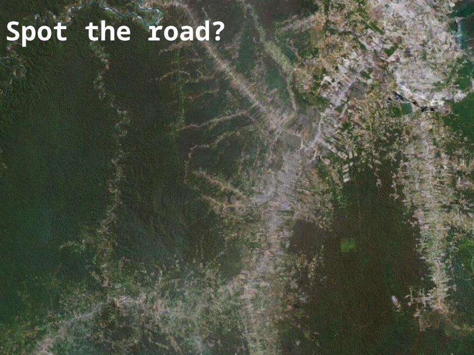
Spot the road?

Project outcomes
This project presents a habitat change monitoring methodology that can be used to identify environmental impacts of road
construction, and support improved design of future projects that would minimize negative environmental impacts.
The project has also helped understand the nature of environmental impacts of road infrastructure projects in distinct contexts across Latin America, demonstrating the importance of
policy and ecosystem specific safeguards.

Objectives of the project
• Evaluate the environmental impacts of road infrastructure in the past through monitoring of natural habitat loss pre- and post- construction for 5 road projects across Latin America
• Demonstrate how this can be integrated into a decision support tool – DATABASIN
• Identify entry points by which ex ante assessment can provide improved safeguards

Content1. Methodologies
1.1. Terra-I – Habitat Change Monitoring
2. Road Impact Results
2.1. The BR-364 highway in Brazil.
2.2. The IIRSA projects in Peru.
2.3. The Pan-American Highway in Panama.
2.4. The Santa Cruz – Puerto Suarez corridor in Bolivia.
2.5. The Trans-Chaco Highway in Paraguay.
3. Methodology of the Future Deforestation
Scenarios and Results
4. Carbon-Conservation Interface
5. Conclusions and Recommendations
Photo by Alvaro Gaviria in Cartagena del ChairaParques Nacionales Naturales de Colombia

1.1. Methodologies: Terra-i Methodology
Terra-i is a system that monitoring the habitat change in Latin America using Neural Network and satellite data
We therefore try to learn how each pixel (site) responds to climate, and any anomoly corresponds to human impact.
Neural-network, is a bio-inspired technology which emulates the basic mechanism of a brain.
It allows … To find a pattern in noisy dataset To apply these patterns to new dataset
INPUTS: Past NDVI (MODIS MOD13Q1) Previous Rainfall (TRMM)
OUTPUT: 16 day predicted NDVI4500
5000
5500
6000
6500
7000
7500
8000
8500
9000
1 2 3 4 5 6 7 8 9Time
NDVI
Measurments
Predictions
Interval max
Interval min
4500
5000
5500
6000
6500
7000
7500
8000
8500
9000
1 2 3 4 5 6 7 8 9Time
NDVI
Measurments
Predictions
Interval max
Interval min

1.1. Methodologies: Terra-i
The Bottom-Line
• 250m resolution• Latin American coverage (currently)• Satellite data to monitorithe habitat every 16 days• Identification of habitat change events• Habitat loss data online to visualize and download.
www.terra-i.org

1.1. Methodologies: Interpreting the maps
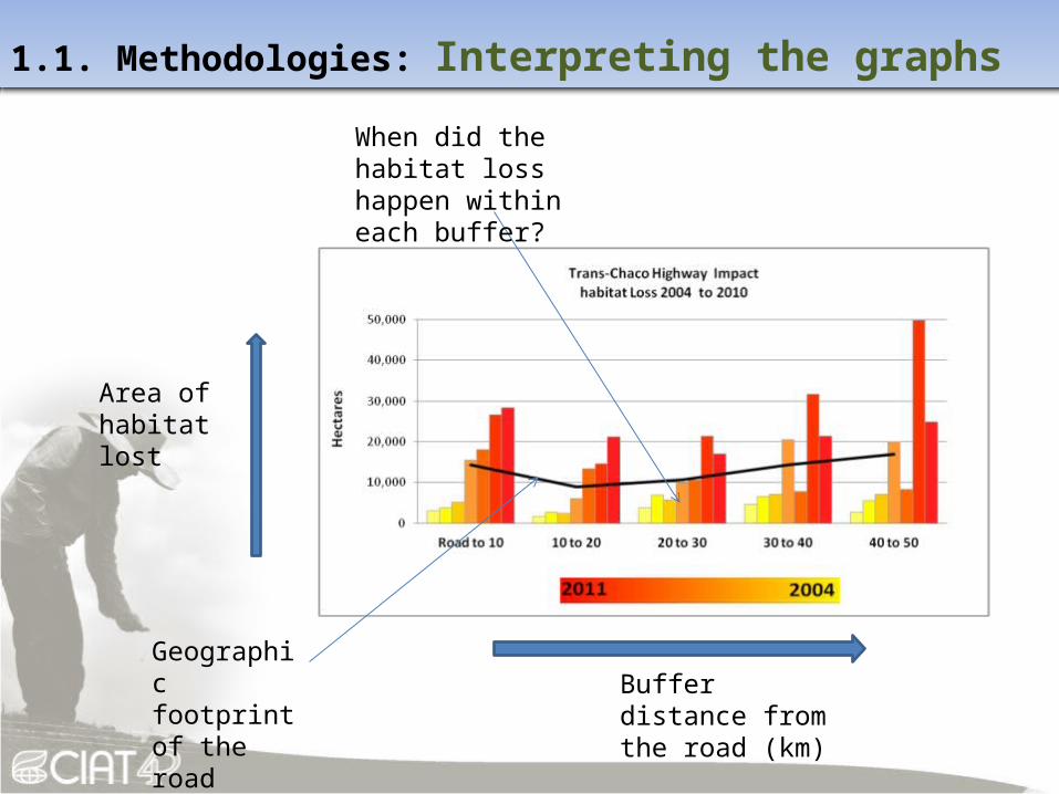
1.1. Methodologies: Interpreting the graphs
Area of habitat lost
Buffer distance from the road (km)
Geographic footprint of the road
When did the habitat loss happen within each buffer?

BR-364 Highway, BrazilDate
Acre Segment: Construction 2002 to 2010Rondonia Segment: Construction 1985 to 1997
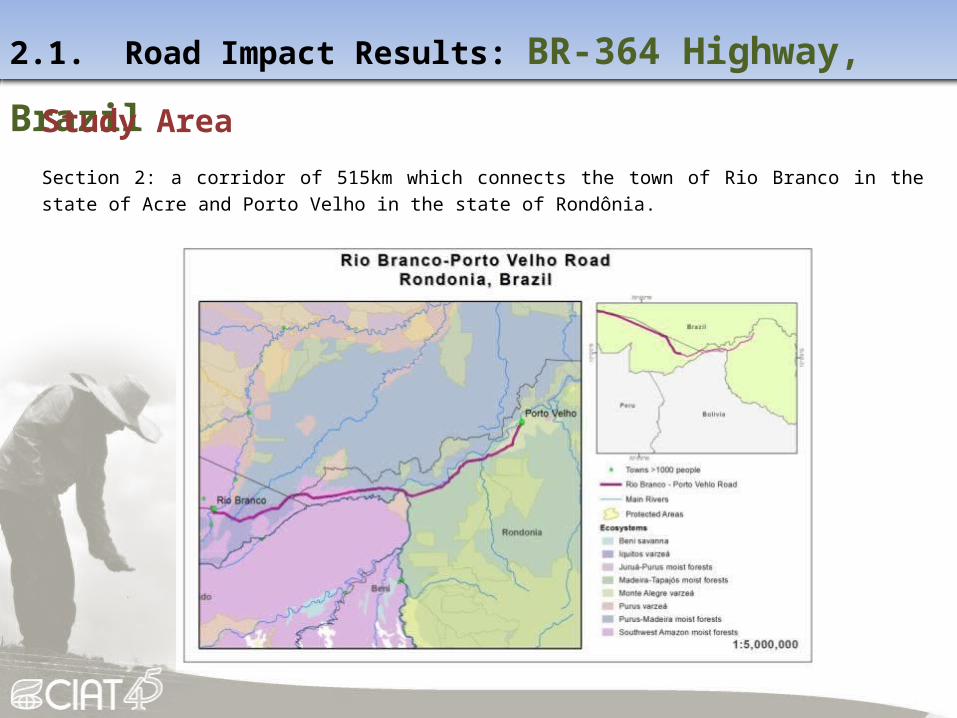
2.1. Road Impact Results: BR-364 Highway, Brazil
Study Area
Section 2: a corridor of 515km which connects the town of Rio Branco in the state of Acre and Porto Velho in the state of Rondônia.
2.1. Road Impact Results: BR-364 Highway, Brazil
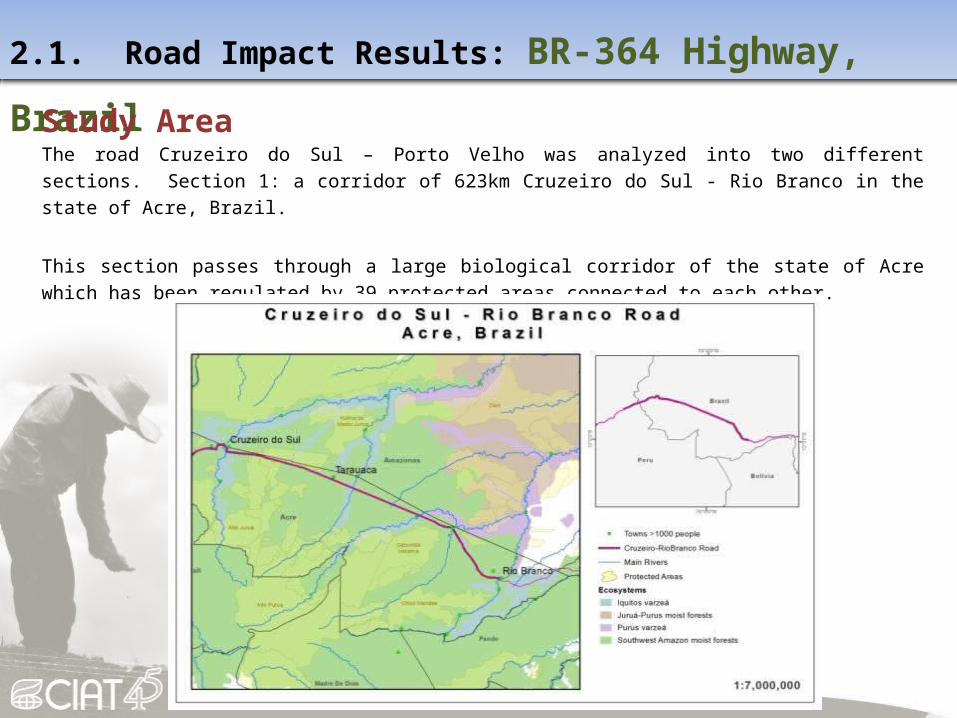
Study AreaThe road Cruzeiro do Sul – Porto Velho was analyzed into two different sections. Section 1: a corridor of 623km Cruzeiro do Sul - Rio Branco in the state of Acre, Brazil.
This section passes through a large biological corridor of the state of Acre which has been regulated by 39 protected areas connected to each other.

2.1. Road Impact Results: BR-364 Highway, Brazil

2.1. Road Impact Results: BR-364 Highway, Brazil
2.1. Road Impact Results: BR-364 Highway, Brazil
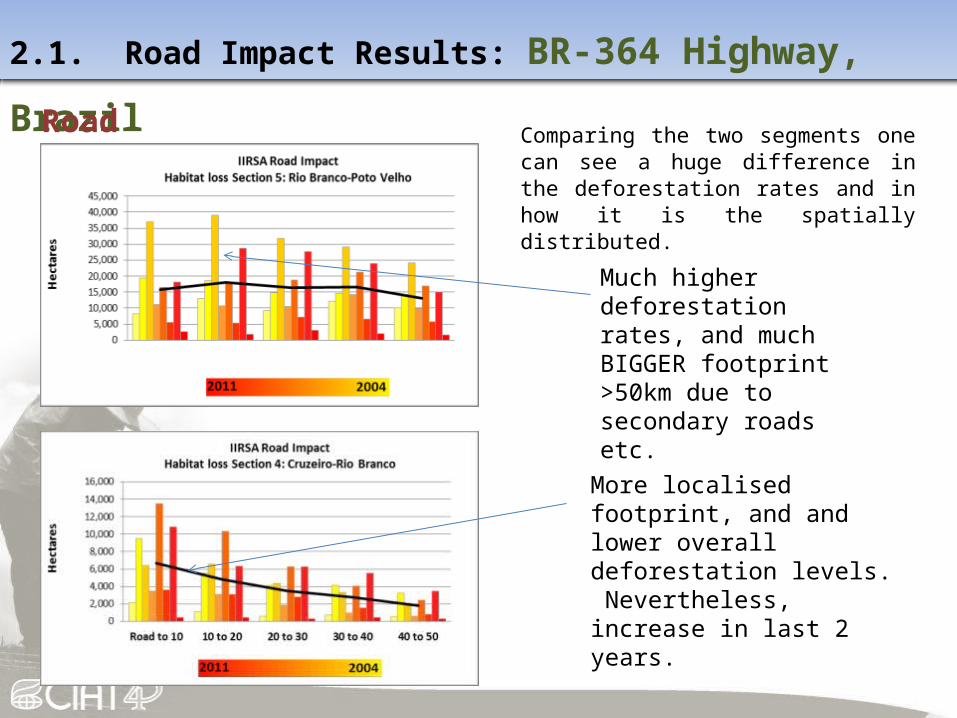
Road impactComparing the two segments one can see a huge difference in the deforestation rates and in how it is the spatially distributed.
More localised footprint, and and lower overall deforestation levels. Nevertheless, increase in last 2 years.
Much higher deforestation rates, and much BIGGER footprint >50km due to secondary roads etc.
2.1. Road Impact Results: BR-364 Highway, Brazil
2.1. Road Impact Results: BR-364 Highway, Brazil
Protected Areas
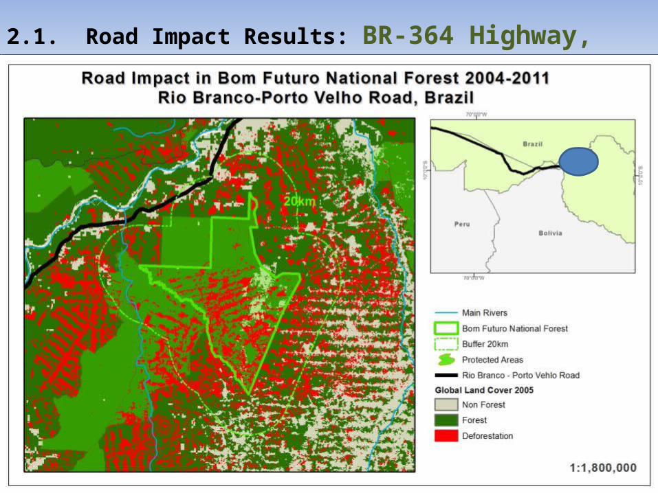
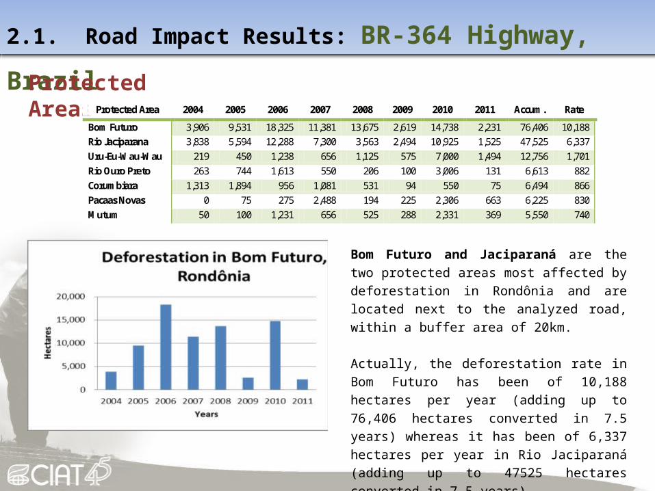
Bom Futuro and Jaciparaná are the two protected areas most affected by deforestation in Rondônia and are located next to the analyzed road, within a buffer area of 20km.
Actually, the deforestation rate in Bom Futuro has been of 10,188 hectares per year (adding up to 76,406 hectares converted in 7.5 years) whereas it has been of 6,337 hectares per year in Rio Jaciparaná (adding up to 47525 hectares converted in 7.5 years).
Protected Area 2004 2005 2006 2007 2008 2009 2010 2011 Accum. Rate
Bom Futuro 3,906 9,531 18,325 11,381 13,675 2,619 14,738 2,231 76,406 10,188 Rio Jaciparana 3,838 5,594 12,288 7,300 3,563 2,494 10,925 1,525 47,525 6,337 Uru-Eu-Wau-Wau 219 450 1,238 656 1,125 575 7,000 1,494 12,756 1,701 Rio Ouro Preto 263 744 1,613 550 206 100 3,006 131 6,613 882 Corumbiara 1,313 1,894 956 1,081 531 94 550 75 6,494 866 Pacaas Novas 0 75 275 2,488 194 225 2,306 663 6,225 830 Mutum 50 100 1,231 656 525 288 2,331 369 5,550 740
2.1. Road Impact Results: BR-364 Highway, Brazil
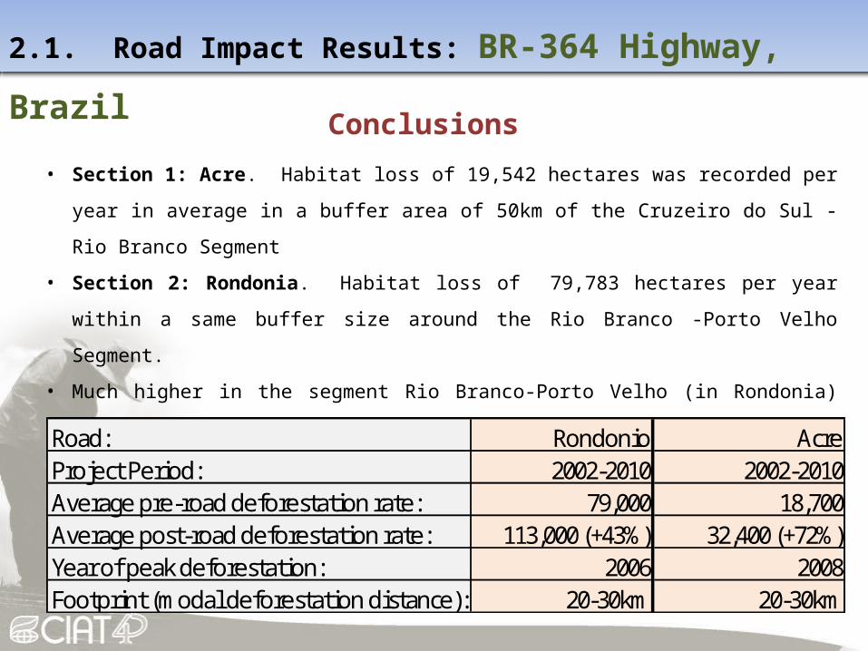
Conclusions
• Section 1: Acre. Habitat loss of 19,542 hectares was recorded per year in average in a buffer area
of 50km of the Cruzeiro do Sul -Rio Branco Segment
• Section 2: Rondonia. Habitat loss of 79,783 hectares per year within a same buffer size around
the Rio Branco -Porto Velho Segment.
• Much higher in the segment Rio Branco-Porto Velho (in Rondonia) than in Cruzeiro do Sul-Rio
Branco (In Acre) likely due to the conservation policies implemented in Acre state. Note fewer
secondary roads, and greater protection from National Parks in segment 1.
Road: Rondonio AcreProject Period: 2002-2010 2002-2010Average pre-road deforestation rate: 79,000 18,700Average post-road deforestation rate: 113,000 (+43%) 32,400 (+72%)Year of peak deforestation: 2006 2008Footprint (modal deforestation distance): 20-30km 20-30km

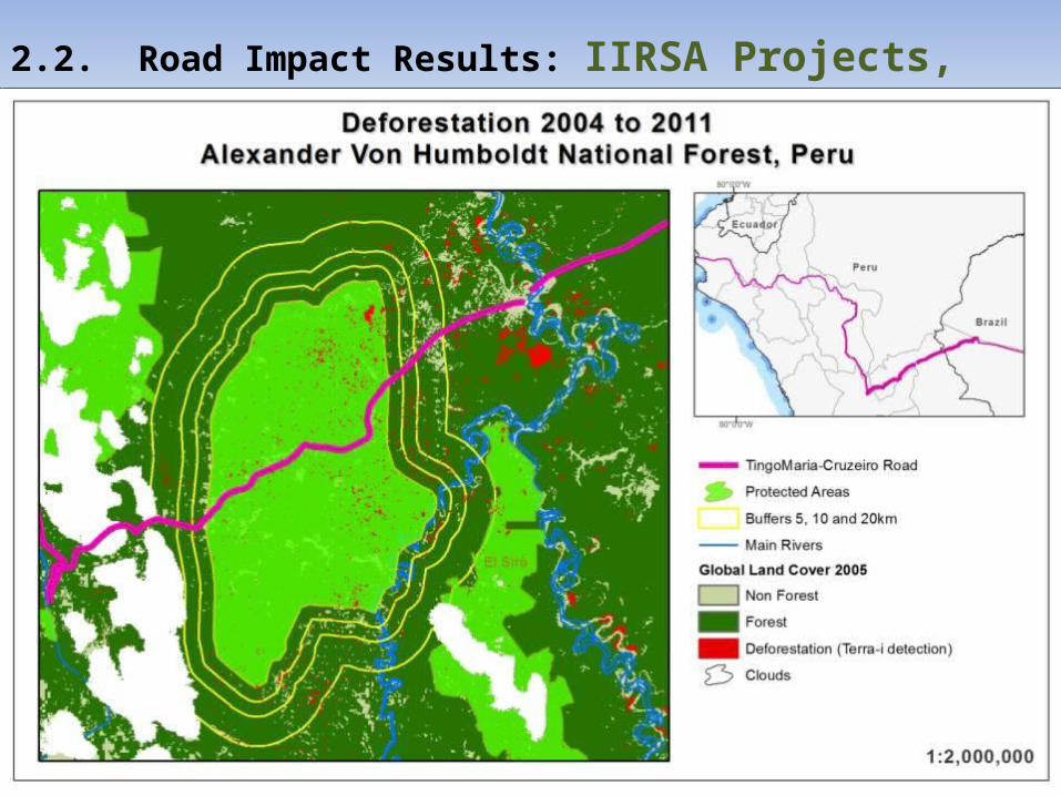
IIRSA Project, PeruDate
Construction: 1998 to 2007

2.2. Road Impact Results: IIRSA Projects, Peru
Study AreaThe analyzed roads have a total length of 1584km and go through all Peru from the Pacific coast to the Acre state in Brazil. The road was split into three different sections for the analysis:
Section 1Andean
Section 2Piedemonte
Section 3Amazon
Section 1: 752km.
Paita on the Pacific coast
(Piura) to Tarapoto.
Section 2: 381km.
Tarapoto - Huanuco (where
it passes 2km away from
Tingo Maria National Park).
Section 3: 451km.
Tingo Maria (Huanuco) -
Cruzeiro do Sul (Acre, Brazil).

2.2. Road Impact Results: IIRSA Projects, Peru

2.2. Road Impact Results: IIRSA Projects, Peru
Road Impact
Section 1 (Paita-Tarapoto) : accumulated loss of 40,794 hectares (5,439 Ha/yr).
0
1,000
2,000
3,000
4,000
5,000
6,000
Road to 10 10 to 20 20 to 30 30 to 40 40 to 50
Hect
ares
IIRSA Road ImpactHabitat loss Section 1: Patia-Tarapoto
Most habitat loss in first 10km (45%)
Significant increase in deforestation in past 3-4 years

2.2. Road Impact Results: IIRSA Projects, Peru

2.2. Road Impact Results: IIRSA Projects, Peru
Road Impact
Section 2 (Tarapoto-Tingo Maria) : accumulated loss of 30,763 Ha (4,102 Ha/yr). Most impacted areas are located in a buffer of 30km from the road.
0
500
1,000
1,500
2,000
2,500
3,000
Road to 10 10 to 20 20 to 30 30 to 40 40 to 50
Hect
ares
IIRSA Road ImpactHabitat loss Section 2: Tarapoto-TingoMaria
Most habitat loss in first 30km (88%)
Significant increase in deforestation in past 3-4 years

2.2. Road Impact Results: IIRSA Projects, Peru

2.2. Road Impact Results: IIRSA Projects, Peru
Road Impact
Section 3 (Tingo Maria-Cruzeiro): accumulated loss of 58,900 hectares (7,853 Ha/year). Most impacted areas are located in a buffer of 30km from the road.
0
1,000
2,000
3,000
4,000
5,000
6,000
7,000
Road to 10 10 to 20 20 to 30 30 to 40 40 to 50
Hect
ares
IIRSA Road ImpactHabitat loss Section 3: TingoMaria-Cruzeiro
Most habitat loss in first 30km (81%)
No apparent increase in deforestation during or after road construction
2.2. Road Impact Results: IIRSA Projects, Peru

2.2. Road Impact Results: IIRSA Projects, Peru
Conclusions
Section 1: Andes. Footprint more localised (<10km), 25% increase in habitat loss post-
project versus pre-project.
Section 2: Piedemonte. Larger footprint (10-20km), and > doubling of deforestation after
road finalization.
Section 3: Tingo Mario-Cruzeiro. High baseline levels of deforestation in the region, but
no increase since road project (major sections of road still not complete).
Road: IIRSA, Peru, Section 1 IIRSA, Peru, Section 2 IIRSA, Peru, Section 3Project period: 1998-2007 1998-2007 1998-2007Average pre-road deforestation rate: 4,900 2,300 7,600Average post-road deforestation rate: 6,100 (+25%) 5,200 (+125%) 7,500 (-1%)Year of peak deforestation: 2010 2010 2005Footprint (modal deforestation distance): 0-10km 10-20km 10-20km

Pan-American Highway, PanamaDate
Construction: 1985 to 1990
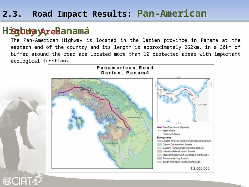
2.3. Road Impact Results: Pan-American Highway, Panamá
Study AreaThe Pan-American Highway is located in the Darien province in Panama at the eastern end of the country and its length is approximately 262km, in a 30km of buffer around the road are located more than 10 protected areas with important ecological functions.

2.3. Road Impact Results: Pan-American Highway, Panamá
Habitat Change Monitoring
Methodology
i. Reclassify the Land Cover Maps of 1992 and 2000 using ArcGIS software in Vegetation and non
vegetation maps.
ii. Generated the deforestation map of 1992-2000.
iii.Applied the Terra-I Methodology to monitoring the habitat change between 2004 to 2010.
iv.Analyze the road impact in buffers areas in 10, 20, 30, 40 and 50km of the road.
MAIN INPUTS For generated deforestation maps before 2000:
A dataset of land cover produced by the Forest Information System Project, the National Environmental Authority (ANAM) for 1992 and 2000.
For generated deforestation maps between 2004 and 2010: Terra-I dataset.

2.3. Road Impact Results: Pan-American Highway, Panamá

2.3. Road Impact Results: Pan-American Highway, Panamá
Buffers Area 1992-2000 2004-2010 Total loss %Loss
Road to 10km 253,546 77,930 3,675 81,605 32% 10km to 20km 260,711 37,391 1,606 38,997 15% 20km to 30km 539,159 39,849 4,700 44,549 8% 30km to 40km 497,927 16,051 2,531 18,583 4% 40km to 50km 380,294 7,466 1,844 9,310 2% Road to 50km 2,450,696 272,150 18,231 290,381 12%
The habitat loss is greater the
closest it’s to the road.
Vast majority of habitat change
occurred in the 1990’s directly
after road construction.
Deforestation 2004-2011 < 10%
of 1990’s levels.
Road impact
2.3. Road Impact Results: Pan-American Highway, Panamá
Conclusions
• Between 1992 and 2000 there was an alarming loss of 7% of the total national forest cover in Panama which is equivalent to 497,306 hectares. This deforestation is localized mostly in the provinces of Panama and Darien and close to the road.
• The impact occurs mainly in the direct influence area of the road (0 to 10km).
• The Darien province lost 24% of its forests, and Panama 23%. Most of this deforestation occurred in Mixed Cative forest in order to create new cropland areas.

Santa Cruz-Puerto Suarez, BoliviaDate
Construction: 2000 to 2011
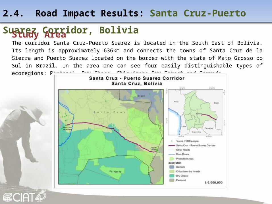
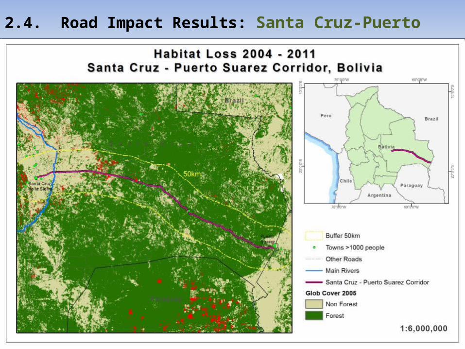
2.4. Road Impact Results: Santa Cruz-Puerto Suarez Corridor, Bolivia
Study AreaThe corridor Santa Cruz-Puerto Suarez is located in the South East of Bolivia. Its length is approximately 636km and connects the towns of Santa Cruz de la Sierra and Puerto Suarez located on the border with the state of Mato Grosso do Sul in Brazil. In the area one can see four easily distinguishable types of ecoregions: Pantanal, Dry Chaco, Chiquitano Dry Forest and Cerrado
2.4. Road Impact Results: Santa Cruz-Puerto Suarez Corridor, Bolivia
2.4. Road Impact Results: Santa Cruz-Puerto Suarez Corridor, Bolivia
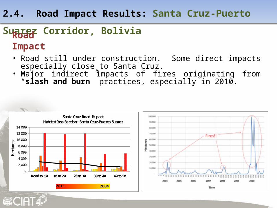
Road Impact
• Road still under construction. Some direct impacts especially close to Santa Cruz.
• Major indirect impacts of fires originating from “slash and burn” practices, especially in 2010.
0
2,000
4,000
6,000
8,000
10,000
12,000
14,000
Road to 10 10 to 20 20 to 30 30 to 40 40 to 50
Hect
ares
Santa Cruz Road ImpactHabitat loss Section: Santa Cruz-Puerto Suarez

2.4. Road Impact Results: Santa Cruz-Puerto Suarez Corridor, Bolivia
Conclusions
• Too early to say what direct impacts are until road fully connects Bolivia with Brazil
• Nevertheless, clear indirect impact through fires originating from slash and burn
activity, especially in the region of Santa Cruz
Road: Santa Cruz-Puerto SuarezProject period: 2000-2011Average pre-road deforestation rate: 11,392Average post-road deforestation rate: N/AYear of peak deforestation: 2010Footprint (modal deforestation distance): 20-30km

Trans-Chaco Highway, ParaguayDate
Construction: 2002 to 2006

2.5. Road Impact Results: The Trans-Chaco Highway, Paraguay
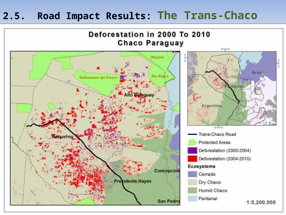
Study AreaThe trans-Chaco highway length approximately 736km, extending from the boundaries between Bolivia and Paraguay near the military post Mayor Infante Rivarola in the department of Boqueron until it intersects with the 9th Road which runs through the Dry Chaco in Boqueron continuing through the department of Presidente Hayes across the humid Chaco region up to the Asuncion metropolitan area in the Central Department.

2.5. Road Impact Results: The Trans-Chaco Highway, Paraguay
Habitat Change Monitoring
Methodology
i. Classify the Landsat-4 satellite images using the k-Means Algorithm .
ii. Generated the deforestation map of 2000-2004.
iii.Applied the Terra-I Methodology to monitoring the habitat change between 2004 to 2011.
iv.Analyze the road impact in buffers areas in 10, 20, 30, 40 and 50km of the road.
MAIN INPUTS For generated deforestation maps between 2000 and 2004:
Dataset from the high spatial resolution satellite Landsat 4 Thematic Mapper in the Dry Chaco ecoregion.
For generated deforestation maps between 2004 and 2010: Terra-I dataset.
2.5. Road Impact Results: The Trans-Chaco Highway, Paraguay
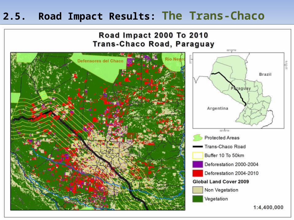
2.5. Road Impact Results: The Trans-Chaco Highway, Paraguay
2.5. Road Impact Results: The Trans-Chaco Highway, Paraguay
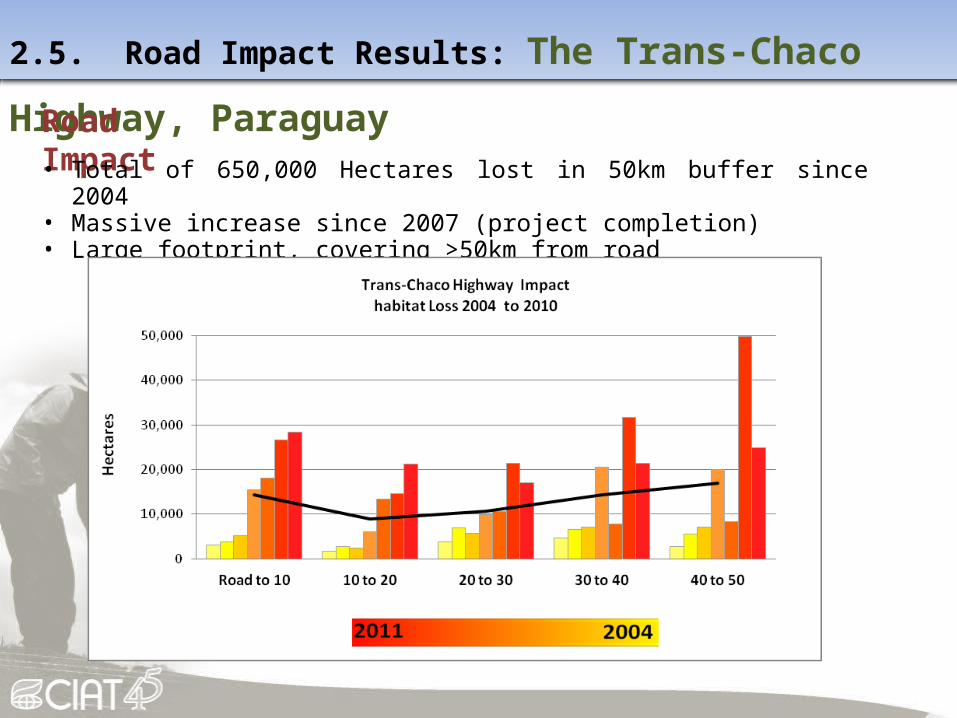
Road Impact• Total of 650,000 Hectares lost in 50km buffer since 2004• Massive increase since 2007 (project completion)• Large footprint, covering >50km from road
2.5. Road Impact Results: The Trans-Chaco Highway, Paraguay
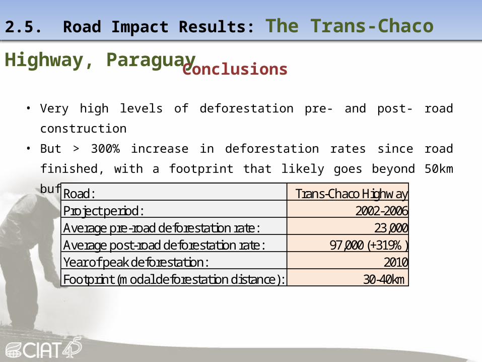
Conclusions
• Very high levels of deforestation pre- and post- road construction
• But > 300% increase in deforestation rates since road finished, with a footprint that
likely goes beyond 50km buffer
Road: Trans-Chaco HighwayProject period: 2002-2006Average pre-road deforestation rate: 23,000Average post-road deforestation rate: 97,000 (+319%)Year of peak deforestation: 2010Footprint (modal deforestation distance): 30-40km
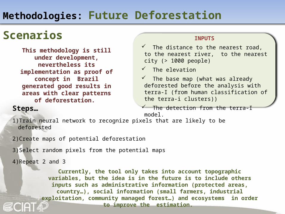
Methodologies: Future Deforestation Scenarios
Steps…
1) Train neural network to recognize pixels that are likely to be deforested
2) Create maps of potential deforestation
3) Select random pixels from the potential maps
4) Repeat 2 and 3
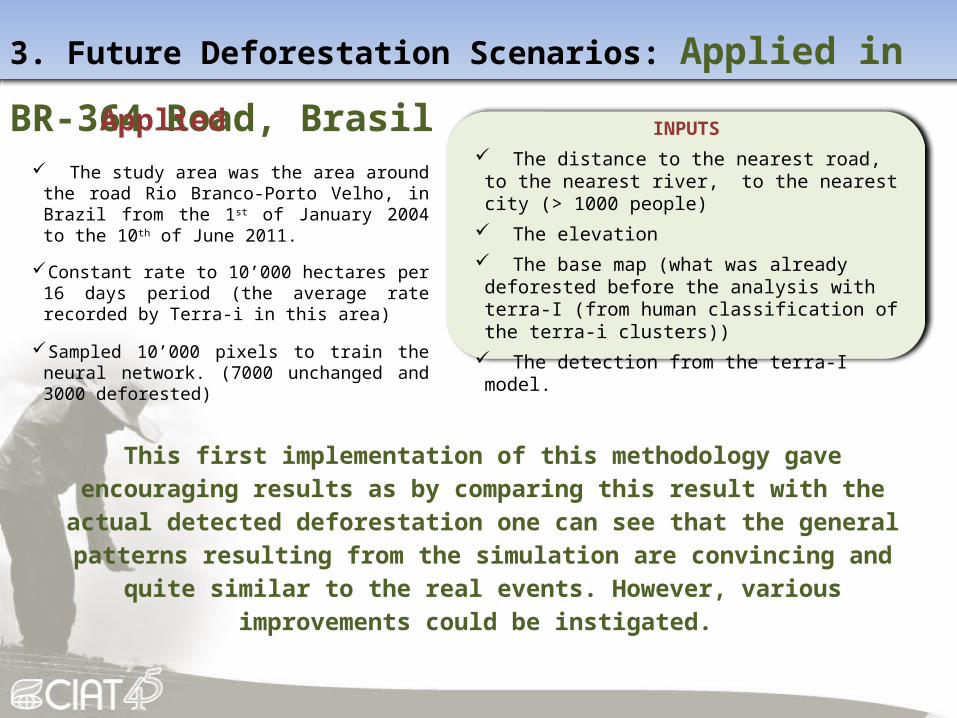
INPUTS The distance to the nearest road, to the nearest river,
to the nearest city (> 1000 people) The elevation The base map (what was already deforested before the
analysis with terra-I (from human classification of the terra-i clusters))
The detection from the terra-I model.
This methodology is still under development, nevertheless its implementation as proof of concept in Brazil generated good results in
areas with clear patterns of deforestation.
Currently, the tool only takes into account topographic variables, but the idea is in the future is to include others inputs such as administrative information (protected areas, country…),
social information (small farmers, industrial exploitation, community managed forest…) and ecosystems in order to improve the estimation.
3. Future Deforestation Scenarios: Applied in BR-364 Road, Brasil
Applied The study area was the area around the road Rio
Branco-Porto Velho, in Brazil from the 1st of January 2004 to the 10th of June 2011.
Constant rate to 10’000 hectares per 16 days period (the average rate recorded by Terra-i in this area)
Sampled 10’000 pixels to train the neural network. (7000 unchanged and 3000 deforested)
This first implementation of this methodology gave encouraging results as by comparing this result with the actual detected deforestation one can see that the
general patterns resulting from the simulation are convincing and quite similar to the real events. However, various improvements could be instigated.
INPUTS The distance to the nearest road, to the nearest river,
to the nearest city (> 1000 people) The elevation The base map (what was already deforested before the
analysis with terra-I (from human classification of the terra-i clusters))
The detection from the terra-I model.
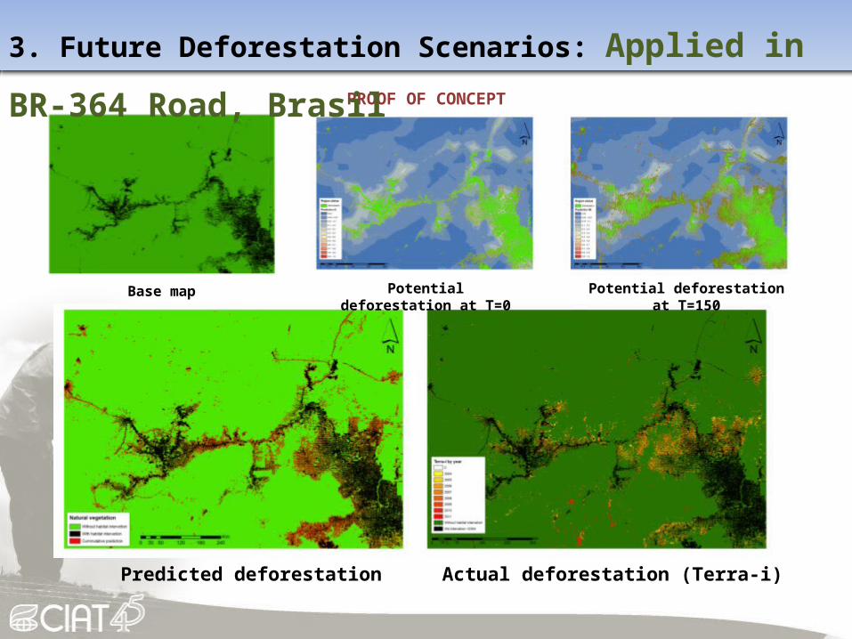
Potential deforestation at T=0 Potential deforestation at T=150
Predicted deforestation Actual deforestation (Terra-i)
Base map
PROOF OF CONCEPT
3. Future Deforestation Scenarios: Applied in BR-364 Road, Brasil

4. Carbon-Conservation Interface
Methodology

4. Carbon-Conservation Interface
Inputs Critical Natural Habitat (species, Protected Areas, Terrestrial Ecosystems) Natural Habitat (terrestrial Ecosystems) Other Conservation Value (CI Hotspots, TNC Portfolio Sites) Carbon

4. Carbon-Conservation Interface
Output
Final Index Value Combined Carbon and Biodiversity.


A synthesis of findingsRoad: Rondonio Acre IIRSA, Peru, Sect. 1 IIRSA, Peru, Sect. 2 IIRSA, Peru, Sect. 3 Trans-Chaco HighwayProject Period: 2002-2010 2002-2010 1998-2007 1998-2007 1998-2007 2002-2006Average pre-road deforestation rate: 79,000 18,700 4,900 2,300 7,600 23,000Average post-road deforestation rate: 113,000 (+43%) 32,400 (+72%) 6,100 (+25%) 5,200 (+125%) 7,500 (-1%) 97,000 (+319%)Year of peak deforestation: 2006 2008 2010 2010 2005 2010Footprint (modal deforestation distance): 20-30km 20-30km 0-10km 10-20km 10-20km 30-40km
• Roads clearly a significant driver of deforestation and land-use change, demonstrated in all 5 projects studies. Impacts are both direct and indirect.
• A road makes a different “footprint” depending on the ecosystem (Andes <10km, Amazon ~50km, Chaco >50km).

Lessons learned• Other factors such as secondary roads and rivers are
important drivers of habitat change and roads open access to them.
• As a Monitoring Tool Terra-I is only useful to analyze projects after 2004. In the cases of Acre-Rondonia, Peru and Paraguay we had three cases where the full power of Terra-I could be shown.
• Local, national and international policies are clearly important contexts that should be taken into account during and after road construction as they have a clear link to land-use change and can contribute to mitigation or exacerbation of the road project encironmental impact.

Policy Recommendations• Regional and national environmental policies in place can significantly reduce the
number of hectares deforested during and after the road construction project. The most outstanding case can be found in Brazil where Rondonia has higher deforestation rates compared to Acre.
• Most of the protected areas affected directly or indirectly by the road construction, were established after the roads where built. In cases were critical ecosystems are endangered, policy makers and development planners should consider for the future, well in advance, critical natural habitats for conservation and biodiversity hotspots.
• It’s expected that infrastructure allows the expansion of economic activities. In this sense, national and regional policies and incentives to promote sustainable and environmentally friendly agricultural practices are also important. In the case of the slash and burn method in Bolivia and Peru causing multiple forest fires, more national policies and programs to promote more sustainable practices should be in place, such as the Slash and Mulch Agroforestry Systems. It’s also key to have increased productivity. Land policy and law enforcement are also relevant in terms of reducing the negative environmental impact of road infrastructure.

Thank you!
Acknowledgements
This Consultancy Project was conducted by the International Center for Tropical Agriculture (CIAT), the Nature
Conservancy (TNC), and the Conservation Biology Institute (CBI) for the Environmental and Social Safeguards Unit of
the Inter-American Development Bank. This project was supported with funds from the German Federal
Bundesministerium fuer wirtschaftliche Zusammenarbeit und Entwicklung (BMZ) in the framework of a cooperation
program between the Inter-American Development Bank (IDB) and the Deutsche Gesellschaft fuer Internationale
Zusammenarbeit (GIZ).