riverdale, bronx nyc streetscape · pdf fileriverdale, bronx nyc . streetscape report . a...
TRANSCRIPT
7875677.2
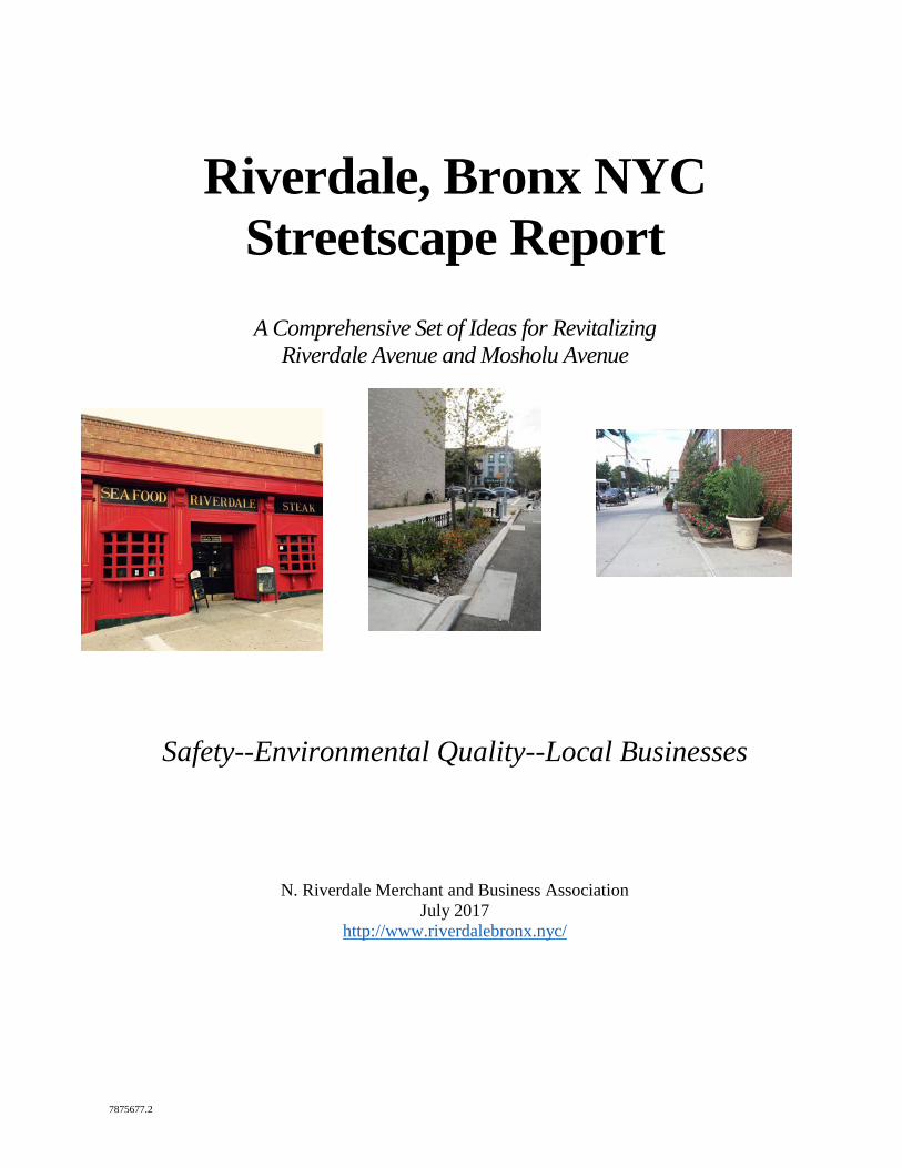
Riverdale, Bronx NYC Streetscape Report
A Comprehensive Set of Ideas for Revitalizing
Riverdale Avenue and Mosholu Avenue
Safety--Environmental Quality--Local Businesses
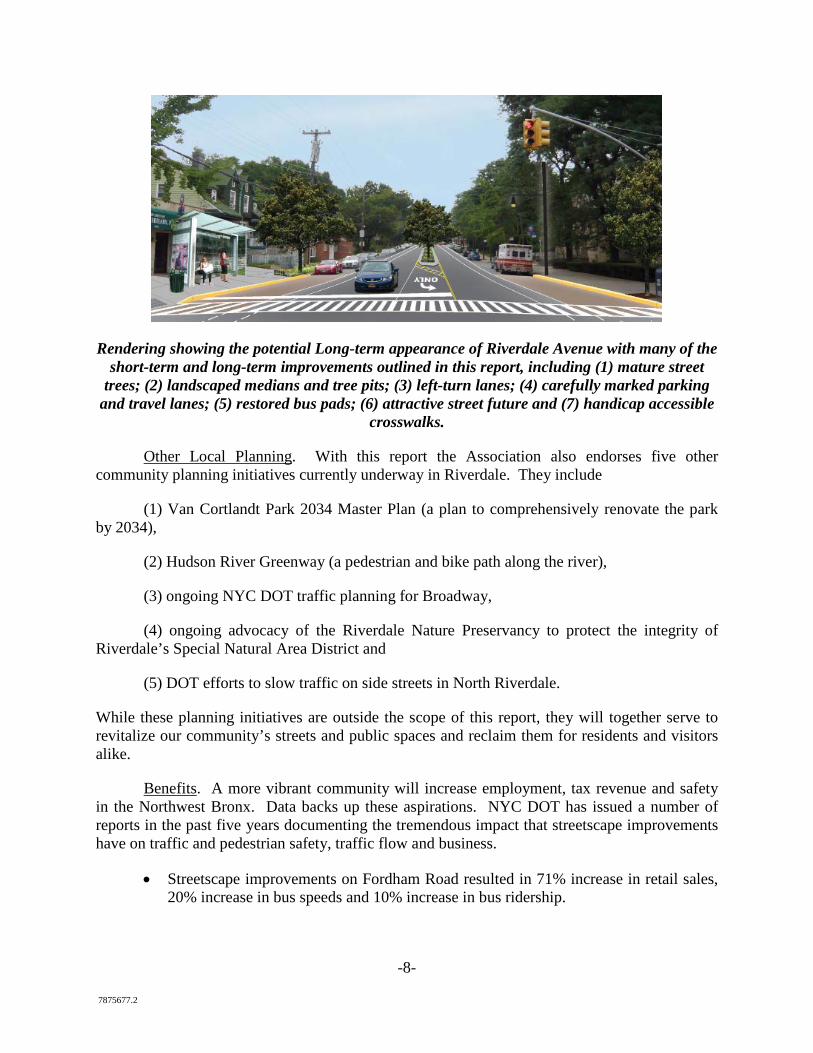
N. Riverdale Merchant and Business Association July 2017
http://www.riverdalebronx.nyc/
TABLE OF CONTENTS
Page
i
7875677.2
1. Request for DOT Study and Implementation of Safety Improvements in 2017................11
1.1. Re-Pave, Re-Mark and Re-Stripe Riverdale Avenue and Mosholu Avenue .........11
1.2. Skyview Shopping Center......................................................................................11
1.3. Carefully Mark Mosholu Avenue without changing basic traffic flow .................12
1.4. Create Safe Pedestrian Connections ......................................................................14
A. Sidewalk on West 254th Street to Metro-North Railroad Station ...................14
B. Independence Avenue Connecting Skyview and West 261st Street ...............15
C. Sidewalk on Netherland Avenue Connecting West 256th and West ..............16
254th Streets ............................................................................................................16
1.5. Repair Deteriorated Sidewalks ..............................................................................16
1.6. Create New Crosswalks .........................................................................................18
1.7. Upgrade Crosswalks for ADA Compliance ...........................................................22
1.8. Install Pedestrian Countdown Signals ...................................................................23
1.9. Create New Pedestrian Refuge Areas ....................................................................23
1.10. Restore the Median of Fieldston Road...................................................................25
1.11. Repave Bus Pads ....................................................................................................26
1.12. Create Left-Turn Lanes and Lights ........................................................................26
1.13. Install State-of-the-Art Traffic Signal Controllers .................................................26
1.14. Prohibit Truck Turns on Riverdale Avenue at W. 259th St ...................................27
2. Beautification and Non-Traffic Improvements ..................................................................28
2.1. Install Modern Street Furniture ..............................................................................28
2.2. Replace Dead Street Trees .....................................................................................30
2.3. Enhance trees pits ..................................................................................................30
2.4. Control animal waste and cigarette litter. ..............................................................31
2.5. Create Pocket Parks ...............................................................................................31
2.6. Develop a maintenance plan for public spaces. .....................................................32
2.7. Install a uniform series of Street Lights .................................................................33
2.8. Install Landscaping and Welcoming Signs at Key Locations ...............................34
2.9. Install Way-Finding Signage .................................................................................37
2.10. Install Banners .......................................................................................................37
2.11. Install Green Infrastructure ....................................................................................38
2.12. Create Public Art Programs ...................................................................................38
2.13. Create New Farmers Markets ................................................................................39
ii
7875677.2
2.14. Bring Local Institutions to Riverdale Avenue .......................................................39
2.15. Install Environmental and Historic Information ....................................................39
2.16. Create a Façade, Fence and Landscape Improvement Program ............................40
2.17. Create a Property Tax Abatement Program ...........................................................41
2.18. Support sidewalk cafes. .........................................................................................42
2.19. Subway Connectivity .............................................................................................42
2.20. Tactical or Guerilla Urbanism ...............................................................................42
2.21. Security ..................................................................................................................44
2.22. Broadway ...............................................................................................................44
2.23. Responsibility ........................................................................................................45
3. Request to DOT to Study Traffic Calming and Pedestrian, Motorist and Parking Safety 46
3.1. Study a Road Diet on Riverdale Avenue ...............................................................46
3.2. Study a Parking Lane Buffer on Riverdale Avenue ...............................................50
3.3. Study Intersection Safety .......................................................................................50
3.4. Protect Side Streets ................................................................................................50
3.5. Study Student Loading/Unloading Zones at Local Schools ..................................51
Included in print version: Exhibit A: 2015 Existing Conditions Report Exhibit B: Summary of Public Comments and Responses Exhibit C: Long Term Ideas for Beautification and Traffic
1. Raised, landscaped median 2. Traffic circle at the City Line 3. Bury power lines
Exhibit D: Supporters of Streetscape Report Included online at www.riverdalebronx.nyc Exhibit E: VHB Analysis of Road Diet on Riverdale Avenue Exhibit F: NYC DOT Presentation Regarding Vision Zero Program Exhibit G: NYC DOT Report Regarding Vision Zero Successes in Other Communities Exhibit H: NYC DOT Statistics Regarding Safety and Business Improvements
-1- 7875677.2
-2- 7875677.2
Executive Summary
This report’s goal is to set forth as many viable ideas as possible for turning Riverdale Avenue and Mosholu Avenue (within New York City zip code 10471) into two safe and attractive “main streets” for the many residents, businesses and institutions that make their home here. The Association’s goals are safety, environmental quality and business improvement. The ideas in this report are intended to guide the Association’s advocacy and fundraising around those three Goals. And this report serves as a request to the NYC Department of Transportation “DOT”) to study both immediate and medium term changes and improvements to streets, parking and crosswalks.
About the Association. The North Riverdale Merchant and Business Association formed in 2012. It is an NYS nonprofit corporation and IRS-certified tax-exempt nonprofit. Members include business and property owners, residents and local institutions interested in advocating for business interests and revitalizing Riverdale Avenue, Mosholu Avenue and Broadway in zip code 10471. The Association gives special thanks to local elected officials: (NYC) Councilman Andrew Cohen, NYS Assemblyman Jeffrey Dinowitz, Borough President Ruben Diaz, NYS Senator Jeffrey Klein and Congressman Elliot Engel. The Association also recognizes the support of the Kingsbridge Riverdale Van Cortlandt Development Corporation.
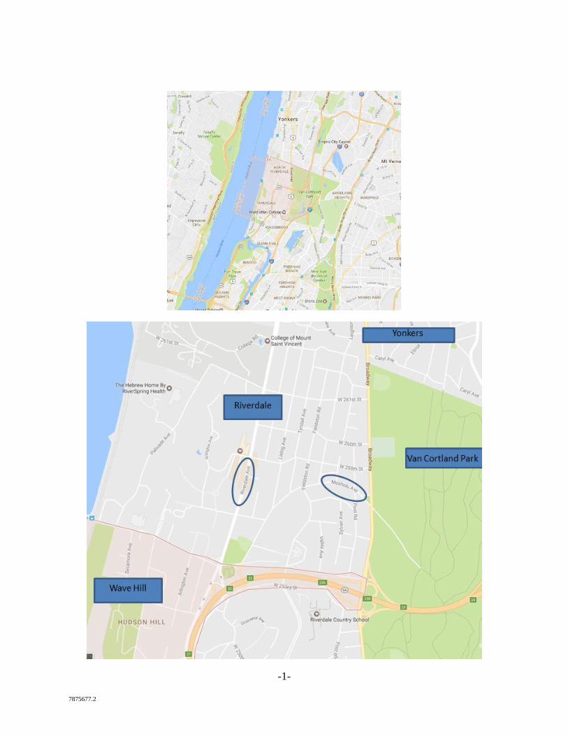
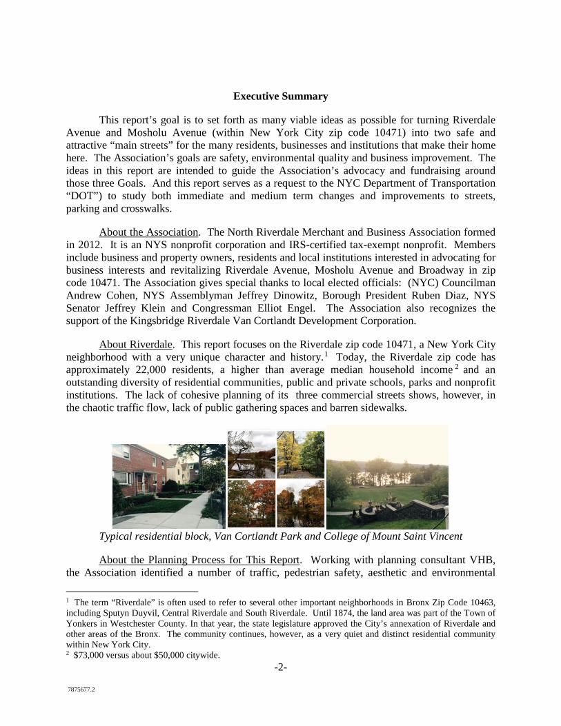
About Riverdale. This report focuses on the Riverdale zip code 10471, a New York City neighborhood with a very unique character and history.1 Today, the Riverdale zip code has approximately 22,000 residents, a higher than average median household income 2 and an outstanding diversity of residential communities, public and private schools, parks and nonprofit institutions. The lack of cohesive planning of its three commercial streets shows, however, in the chaotic traffic flow, lack of public gathering spaces and barren sidewalks.
Typical residential block, Van Cortlandt Park and College of Mount Saint Vincent
About the Planning Process for This Report. Working with planning consultant VHB, the Association identified a number of traffic, pedestrian safety, aesthetic and environmental
1 The term “Riverdale” is often used to refer to several other important neighborhoods in Bronx Zip Code 10463, including Sputyn Duyvil, Central Riverdale and South Riverdale. Until 1874, the land area was part of the Town of Yonkers in Westchester County. In that year, the state legislature approved the City’s annexation of Riverdale and other areas of the Bronx. The community continues, however, as a very quiet and distinct residential community within New York City. 2 $73,000 versus about $50,000 citywide.
-3- 7875677.2
conditions in a 2015 Existing Conditions Report. The executive summary of the Existing Conditions Report is Exhibit A. 3 Lamentably, the report documents speeding, pedestrian injuries and fatalities, deteriorated pedestrian and traffic conditions and deteriorated or missing sidewalks. These conditions stand in stark contrast to the improved conditions DOT has implemented in other communities under Mayor Bloomberg’s complete streets program and Mayor DeBlasio’s Vision Zero Action Plan — a plan to end pedestrian fatalities and serious injuries in the City. And they create a legal and moral obligation for action.
VHB traffic engineers reviewed the City’s Vision Zero program and the types of improvements made in other communities. It evaluated the techniques that would work in Riverdale and they are presented in sections 1 and 3 of this report. Separately, the Association worked with members, its informal advisory group and others to identify non-traffic improvements that could separately be implemented to beautify and improve the business district. These ideas are presented in section 2 of the report.
The Association sought feedback in 2016 on a first draft of this report from the Advisory Committee, elected officials and the public. We conducted approximately 30 one-on-one meetings and conference calls with stakeholders. A summary of all comments and the Association’s responses is presented in Exhibit B. This feedback produced a number of changes to the report. Mostly notably, an earlier draft included Broadway in the body of the report. Since that time, however, the NYC DOT has begun its own study of that street. The Association strongly supports those efforts but does not want to duplicate them and has removed Broadway from the report. Additionally, three recommendations were determined to be too costly or ambitious to be implemented in 2017 and 2018 (landscaped median, buried power lines and traffic circle at city line). The report therefore includes them as Exhibit C.
About Our Goals. The Association expects some of the ideas in this report to warrant immediate implementation—such as pedestrian safety improvements and beautification. Others will require more DOT review and consideration. But all ideas in this report are focused on four core objectives: (1) achieve true pedestrian safety, including no further pedestrian injuries and fatalities; (2) achieve smooth, predictable and safe traffic flow at the community’s new speed limit of 25 miles per hour; (3) create safe, carefully marked parking lanes that allow persons entering and exiting parked cars to stay out of traffic lanes; and (4) create beautiful and environmentally sustainable conditions.
Some residents submitted comments to the Association to focus only on beautification. The Association agrees that beautification and environmental quality are very important to strengthening the community and improving business. But without true pedestrian, parking and traffic safety, commerce will not thrive. Pedestrians and residents must feel safe, welcome and invited. Traffic must move at 25 mph. Riverdale Avenue must cease to serve as a high-speed cut-through from Yonkers to the Henry Hudson Parkway.
Moreover, the 22,000 residents, 3,000 students, hundreds of businesses and dozens of prominent religious and nonprofit institutions that make their home in zip code 10471 deserve a true “main street,” and the Association will work to make sure the City and State hear that
3 www.riverdalebronx.nyc
-4- 7875677.2
message. The Association defers to the DOT in consultation with the community board and community on the specific form the safety improvements should take.
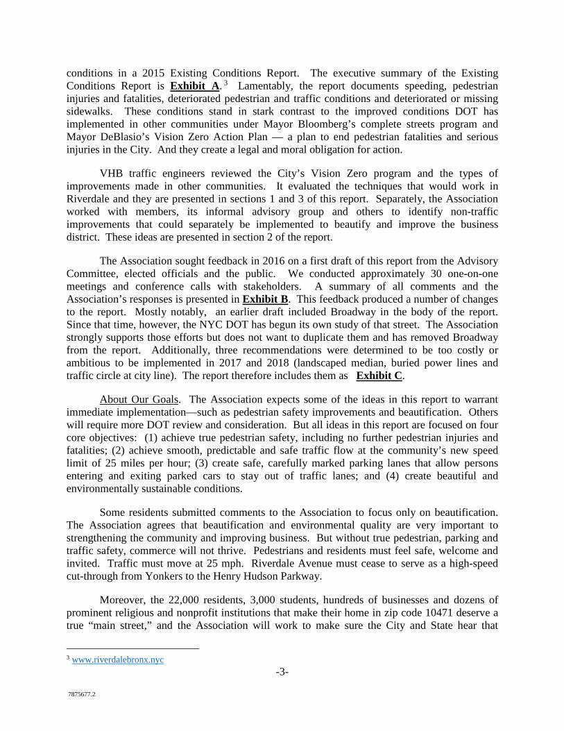
About the Inspiration for This Project. The Association bases this report on successful traffic improvement projects in other communities (inside and outside NYC), careful research by VHB engineers and deep concern about the deteriorated look and feel of Riverdale and Mosholu Avenues. Business owners are deeply concerned about persistent storefront vacancies (about a dozen at any given time), decline in patronage of local stores and traffic/pedestrian safety concerns.
Memorial for man killed by car in 2010
The Association was also inspired by the creative and innovative streetscape projects that both New York City and its suburban neighbors have undertaken in the past decade. Riverdale shares qualities of the region’s best suburban communities, including good public transportation, proximity to midtown Manhattan and diversity of housing options. But unlike its suburban neighbors, it lacks a local municipal government with the staff or budget to focus on revitalizing main street shopping districts. To date there has been no organized effort to revitalize Riverdale Avenue and Mosholu Avenue.
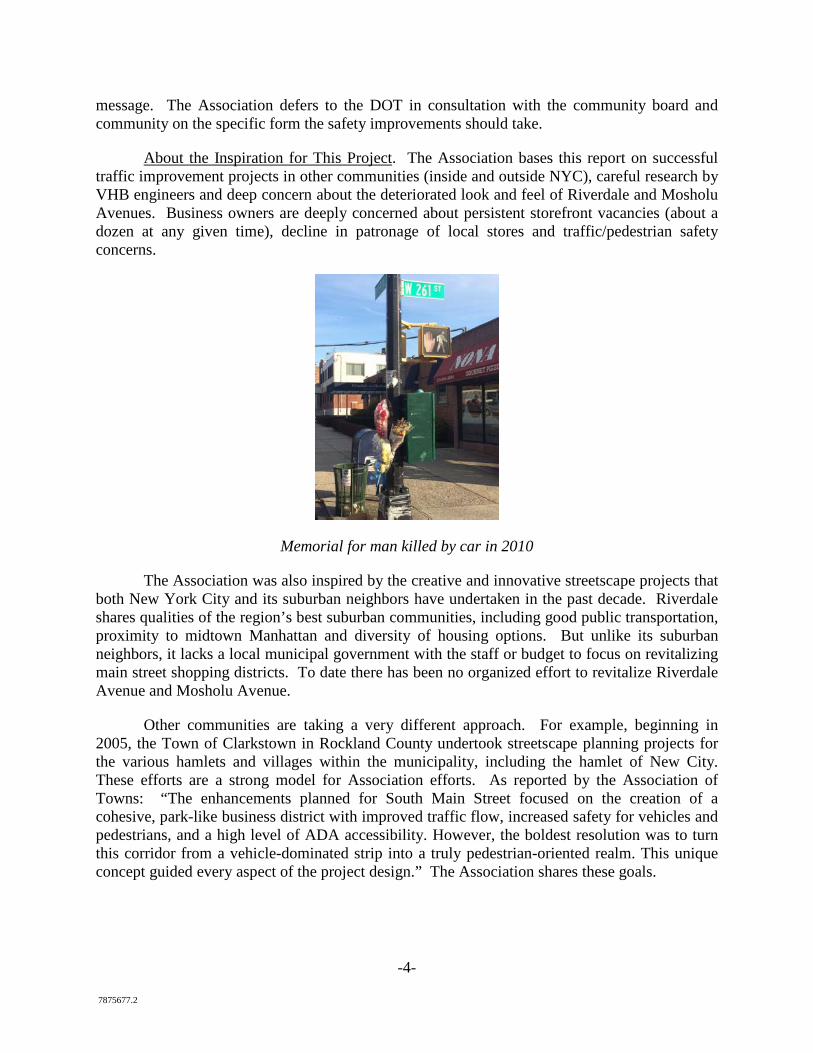
Other communities are taking a very different approach. For example, beginning in 2005, the Town of Clarkstown in Rockland County undertook streetscape planning projects for the various hamlets and villages within the municipality, including the hamlet of New City. These efforts are a strong model for Association efforts. As reported by the Association of Towns: “The enhancements planned for South Main Street focused on the creation of a cohesive, park-like business district with improved traffic flow, increased safety for vehicles and pedestrians, and a high level of ADA accessibility. However, the boldest resolution was to turn this corridor from a vehicle-dominated strip into a truly pedestrian-oriented realm. This unique concept guided every aspect of the project design.” The Association shares these goals.
-5- 7875677.2
Current Conditions in New City
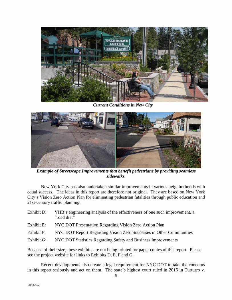
Example of Streetscape Improvements that benefit pedestrians by providing seamless
sidewalks.
New York City has also undertaken similar improvements in various neighborhoods with equal success. The ideas in this report are therefore not original. They are based on New York City’s Vision Zero Action Plan for eliminating pedestrian fatalities through public education and 21st-century traffic planning.
Exhibit D: VHB’s engineering analysis of the effectiveness of one such improvement, a “road diet”
Exhibit E: NYC DOT Presentation Regarding Vision Zero Action Plan Exhibit F: NYC DOT Report Regarding Vision Zero Successes in Other Communities Exhibit G: NYC DOT Statistics Regarding Safety and Business Improvements
Because of their size, these exhibits are not being printed for paper copies of this report. Please see the project website for links to Exhibits D, E, F and G.
Recent developments also create a legal requirement for NYC DOT to take the concerns in this report seriously and act on them. The state’s highest court ruled in 2016 in Turturro v.
-6- 7875677.2
City of New York. That case concerned Gerritsen Avenue in Brooklyn, where DOT had been informed of speeding and safety concerns starting in 2002. When a boy was tragically killed on the road in 2004, his family sued the City for negligence. A jury found in the family’s favor and the City appealed. The highest court rejected that appeal on December 22, 2016, and stated: “We therefore conclude that the specific acts or omissions that plaintiffs claim caused the injury arose from the City's failure to keep Gerritsen Avenue in a reasonably safe condition. Specifically, the City failed to conduct an adequate study of whether to implement roadway design changes that would have controlled speeding.”
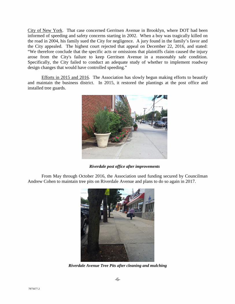
Efforts in 2015 and 2016. The Association has slowly begun making efforts to beautify and maintain the business district. In 2015, it restored the plantings at the post office and installed tree guards.
Riverdale post office after improvements
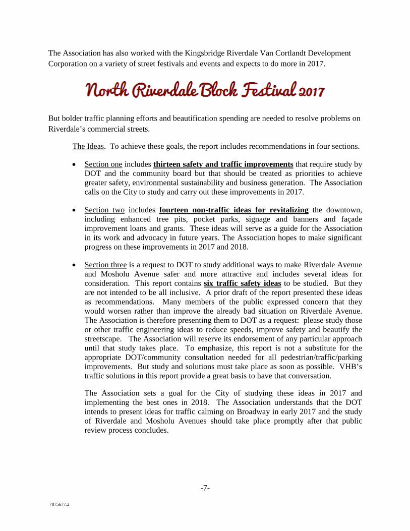
From May through October 2016, the Association used funding secured by Councilman Andrew Cohen to maintain tree pits on Riverdale Avenue and plans to do so again in 2017.
Riverdale Avenue Tree Pits after cleaning and mulching
-7- 7875677.2
The Association has also worked with the Kingsbridge Riverdale Van Cortlandt Development Corporation on a variety of street festivals and events and expects to do more in 2017.
But bolder traffic planning efforts and beautification spending are needed to resolve problems on Riverdale’s commercial streets.
The Ideas. To achieve these goals, the report includes recommendations in four sections.
• Section one includes thirteen safety and traffic improvements that require study by DOT and the community board but that should be treated as priorities to achieve greater safety, environmental sustainability and business generation. The Association calls on the City to study and carry out these improvements in 2017.
• Section two includes fourteen non-traffic ideas for revitalizing the downtown, including enhanced tree pits, pocket parks, signage and banners and façade improvement loans and grants. These ideas will serve as a guide for the Association in its work and advocacy in future years. The Association hopes to make significant progress on these improvements in 2017 and 2018.
• Section three is a request to DOT to study additional ways to make Riverdale Avenue and Mosholu Avenue safer and more attractive and includes several ideas for consideration. This report contains six traffic safety ideas to be studied. But they are not intended to be all inclusive. A prior draft of the report presented these ideas as recommendations. Many members of the public expressed concern that they would worsen rather than improve the already bad situation on Riverdale Avenue. The Association is therefore presenting them to DOT as a request: please study those or other traffic engineering ideas to reduce speeds, improve safety and beautify the streetscape. The Association will reserve its endorsement of any particular approach until that study takes place. To emphasize, this report is not a substitute for the appropriate DOT/community consultation needed for all pedestrian/traffic/parking improvements. But study and solutions must take place as soon as possible. VHB’s traffic solutions in this report provide a great basis to have that conversation.
The Association sets a goal for the City of studying these ideas in 2017 and implementing the best ones in 2018. The Association understands that the DOT intends to present ideas for traffic calming on Broadway in early 2017 and the study of Riverdale and Mosholu Avenues should take place promptly after that public review process concludes.
-8- 7875677.2
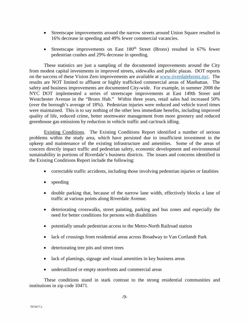
Rendering showing the potential Long-term appearance of Riverdale Avenue with many of the short-term and long-term improvements outlined in this report, including (1) mature street
trees; (2) landscaped medians and tree pits; (3) left-turn lanes; (4) carefully marked parking and travel lanes; (5) restored bus pads; (6) attractive street future and (7) handicap accessible
crosswalks.
Other Local Planning. With this report the Association also endorses five other community planning initiatives currently underway in Riverdale. They include
(1) Van Cortlandt Park 2034 Master Plan (a plan to comprehensively renovate the park by 2034),
(2) Hudson River Greenway (a pedestrian and bike path along the river),
(3) ongoing NYC DOT traffic planning for Broadway,
(4) ongoing advocacy of the Riverdale Nature Preservancy to protect the integrity of Riverdale’s Special Natural Area District and
(5) DOT efforts to slow traffic on side streets in North Riverdale.
While these planning initiatives are outside the scope of this report, they will together serve to revitalize our community’s streets and public spaces and reclaim them for residents and visitors alike.
Benefits. A more vibrant community will increase employment, tax revenue and safety in the Northwest Bronx. Data backs up these aspirations. NYC DOT has issued a number of reports in the past five years documenting the tremendous impact that streetscape improvements have on traffic and pedestrian safety, traffic flow and business.
• Streetscape improvements on Fordham Road resulted in 71% increase in retail sales, 20% increase in bus speeds and 10% increase in bus ridership.
-9- 7875677.2
• Streetscape improvements around the narrow streets around Union Square resulted in 16% decrease in speeding and 49% fewer commercial vacancies.
• Streetscape improvements on East 180th Street (Bronx) resulted in 67% fewer pedestrian crashes and 29% decrease in speeding.
These statistics are just a sampling of the documented improvements around the City from modest capital investments in improved streets, sidewalks and public plazas. DOT reports on the success of these Vision Zero improvements are available at www.riverdalebronx.nyc. The results are NOT limited to affluent or highly trafficked commercial areas of Manhattan. The safety and business improvements are documented City-wide. For example, in summer 2008 the NYC DOT implemented a series of streetscape improvements at East 149th Street and Westchester Avenue in the “Bronx Hub.” Within three years, retail sales had increased 50% (over the borough’s average of 18%). Pedestrian injuries were reduced and vehicle travel times were maintained. This is to say nothing of the other less immediate benefits, including improved quality of life, reduced crime, better stormwater management from more greenery and reduced greenhouse gas emissions by reduction in vehicle traffic and car/truck idling.
Existing Conditions. The Existing Conditions Report identified a number of serious problems within the study area, which have persisted due to insufficient investment in the upkeep and maintenance of the existing infrastructure and amenities. Some of the areas of concern directly impact traffic and pedestrian safety, economic development and environmental sustainability in portions of Riverdale’s business districts. The issues and concerns identified in the Existing Conditions Report include the following:
• correctable traffic accidents, including those involving pedestrian injuries or fatalities
• speeding
• double parking that, because of the narrow lane width, effectively blocks a lane of traffic at various points along Riverdale Avenue.
• deteriorating crosswalks, street painting, parking and bus zones and especially the need for better conditions for persons with disabilities
• potentially unsafe pedestrian access to the Metro-North Railroad station
• lack of crossings from residential areas across Broadway to Van Cortlandt Park
• deteriorating tree pits and street trees
• lack of plantings, signage and visual amenities in key business areas
• underutilized or empty storefronts and commercial areas
These conditions stand in stark contrast to the strong residential communities and institutions in zip code 10471.
-10- 7875677.2
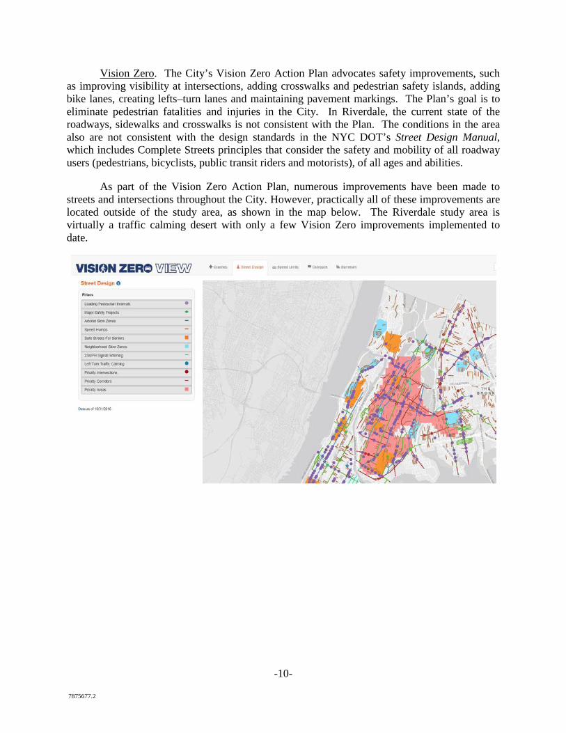
Vision Zero. The City’s Vision Zero Action Plan advocates safety improvements, such as improving visibility at intersections, adding crosswalks and pedestrian safety islands, adding bike lanes, creating lefts–turn lanes and maintaining pavement markings. The Plan’s goal is to eliminate pedestrian fatalities and injuries in the City. In Riverdale, the current state of the roadways, sidewalks and crosswalks is not consistent with the Plan. The conditions in the area also are not consistent with the design standards in the NYC DOT’s Street Design Manual, which includes Complete Streets principles that consider the safety and mobility of all roadway users (pedestrians, bicyclists, public transit riders and motorists), of all ages and abilities.
As part of the Vision Zero Action Plan, numerous improvements have been made to streets and intersections throughout the City. However, practically all of these improvements are located outside of the study area, as shown in the map below. The Riverdale study area is virtually a traffic calming desert with only a few Vision Zero improvements implemented to date.
-11- 7875677.2
1. Request for DOT Study and Implementation of Safety Improvements in 2017
The purpose of this section of the report is to identify thirteen safety improvements to be studied and implemented by the City in 2017. The thirteen requests in this section of the report are based on very specific studies by VHB Engineering and requests from community residents and institutions.
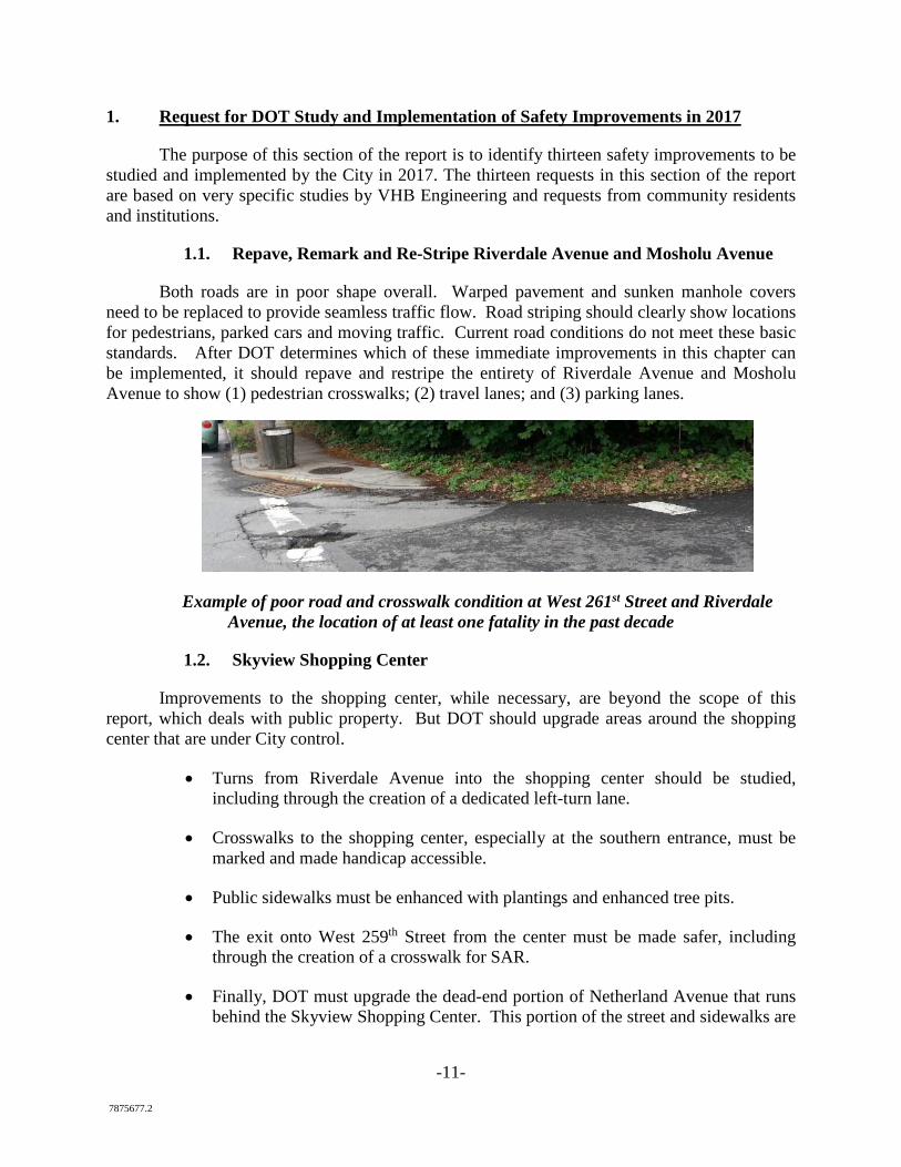
1.1. Repave, Remark and Re-Stripe Riverdale Avenue and Mosholu Avenue
Both roads are in poor shape overall. Warped pavement and sunken manhole covers need to be replaced to provide seamless traffic flow. Road striping should clearly show locations for pedestrians, parked cars and moving traffic. Current road conditions do not meet these basic standards. After DOT determines which of these immediate improvements in this chapter can be implemented, it should repave and restripe the entirety of Riverdale Avenue and Mosholu Avenue to show (1) pedestrian crosswalks; (2) travel lanes; and (3) parking lanes.
Example of poor road and crosswalk condition at West 261st Street and Riverdale Avenue, the location of at least one fatality in the past decade
1.2. Skyview Shopping Center
Improvements to the shopping center, while necessary, are beyond the scope of this report, which deals with public property. But DOT should upgrade areas around the shopping center that are under City control.
• Turns from Riverdale Avenue into the shopping center should be studied, including through the creation of a dedicated left-turn lane.
• Crosswalks to the shopping center, especially at the southern entrance, must be marked and made handicap accessible.
• Public sidewalks must be enhanced with plantings and enhanced tree pits.
• The exit onto West 259th Street from the center must be made safer, including through the creation of a crosswalk for SAR.
• Finally, DOT must upgrade the dead-end portion of Netherland Avenue that runs behind the Skyview Shopping Center. This portion of the street and sidewalks are
-12- 7875677.2
deteriorated and poorly maintained and should be considered part of the business district in any upgrades.
The Association will address the shopping center itself at a later date.
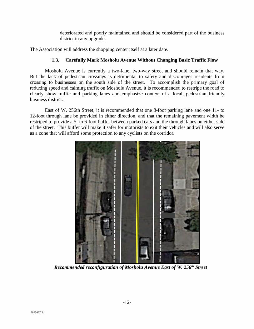
1.3. Carefully Mark Mosholu Avenue Without Changing Basic Traffic Flow
Mosholu Avenue is currently a two-lane, two-way street and should remain that way. But the lack of pedestrian crossings is detrimental to safety and discourages residents from crossing to businesses on the south side of the street. To accomplish the primary goal of reducing speed and calming traffic on Mosholu Avenue, it is recommended to restripe the road to clearly show traffic and parking lanes and emphasize context of a local, pedestrian friendly business district.
East of W. 256th Street, it is recommended that one 8-foot parking lane and one 11- to 12-foot through lane be provided in either direction, and that the remaining pavement width be restriped to provide a 5- to 6-foot buffer between parked cars and the through lanes on either side of the street. This buffer will make it safer for motorists to exit their vehicles and will also serve as a zone that will afford some protection to any cyclists on the corridor.
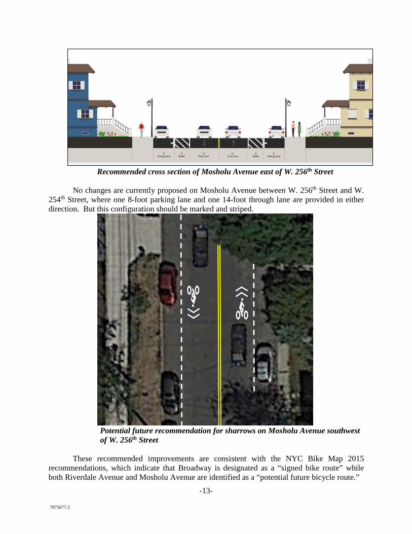
Recommended reconfiguration of Mosholu Avenue East of W. 256th Street
-13- 7875677.2
Recommended cross section of Mosholu Avenue east of W. 256th Street
No changes are currently proposed on Mosholu Avenue between W. 256th Street and W. 254th Street, where one 8-foot parking lane and one 14-foot through lane are provided in either direction. But this configuration should be marked and striped.
Potential future recommendation for sharrows on Mosholu Avenue southwest of W. 256th Street
These recommended improvements are consistent with the NYC Bike Map 2015 recommendations, which indicate that Broadway is designated as a “signed bike route” while both Riverdale Avenue and Mosholu Avenue are identified as a “potential future bicycle route.”
-14- 7875677.2
Further, should Mosholu Avenue be designated in the future as a bicycle route, sharrows (i.e., pavement markings indicating that cyclists share the road with motorists) could be installed on this section of the avenue (as well as on W. 254th Street and W. 256th Street). The Association does not take any position on sharrows at this time.
1.4. Create Safe Pedestrian Connections
Safe pedestrian connections will encourage residents to walk, increasing business and improving community vitality. Moreover, with thousands of schoolchildren using Riverdale Avenue, Mosholu and Broadway to reach their schools, attractive and safe connections are vital. Many such connections are outlined in this plan. Eight improvements deserve special focus.
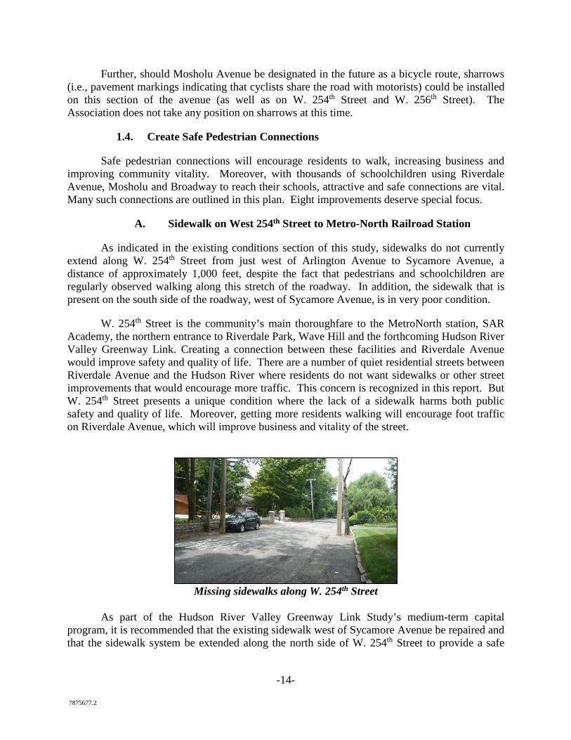
A. Sidewalk on West 254th Street to Metro-North Railroad Station
As indicated in the existing conditions section of this study, sidewalks do not currently extend along W. 254th Street from just west of Arlington Avenue to Sycamore Avenue, a distance of approximately 1,000 feet, despite the fact that pedestrians and schoolchildren are regularly observed walking along this stretch of the roadway. In addition, the sidewalk that is present on the south side of the roadway, west of Sycamore Avenue, is in very poor condition.
W. 254th Street is the community’s main thoroughfare to the MetroNorth station, SAR Academy, the northern entrance to Riverdale Park, Wave Hill and the forthcoming Hudson River Valley Greenway Link. Creating a connection between these facilities and Riverdale Avenue would improve safety and quality of life. There are a number of quiet residential streets between Riverdale Avenue and the Hudson River where residents do not want sidewalks or other street improvements that would encourage more traffic. This concern is recognized in this report. But W. 254th Street presents a unique condition where the lack of a sidewalk harms both public safety and quality of life. Moreover, getting more residents walking will encourage foot traffic on Riverdale Avenue, which will improve business and vitality of the street.
Missing sidewalks along W. 254th Street
As part of the Hudson River Valley Greenway Link Study’s medium-term capital
program, it is recommended that the existing sidewalk west of Sycamore Avenue be repaired and that the sidewalk system be extended along the north side of W. 254th Street to provide a safe
-15- 7875677.2
pedestrian connection between Metro-North’s Riverdale train station and the Riverdale Avenue corridor. This would require using the existing street bed as follows:
• provide an 8-foot parking lane on the south side of the street, where parking is currently permitted,
• a 10-foot through lane in either direction and
• a 5-foot-wide sidewalk (reduced to a minimum of 3 feet where potential obstructions such as trees, utility poles and fire hydrants are present).
These proposed pedestrian safety modifications to W. 254th Street would not change traffic patterns and should not involve widening the roadway as there appears to be sufficient width to provide for two travel lanes and a sidewalk, as well as a parking lane in those areas where parking is permitted.
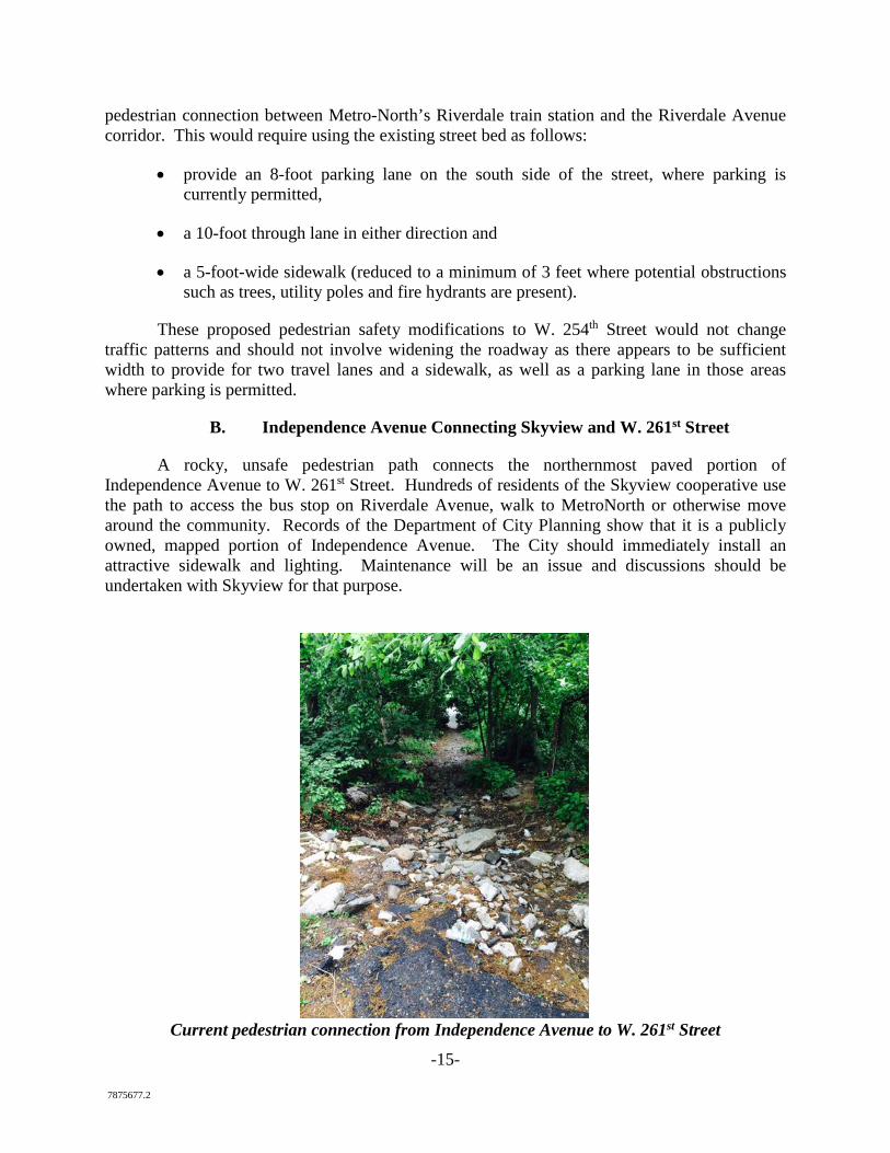
B. Independence Avenue Connecting Skyview and W. 261st Street
A rocky, unsafe pedestrian path connects the northernmost paved portion of Independence Avenue to W. 261st Street. Hundreds of residents of the Skyview cooperative use the path to access the bus stop on Riverdale Avenue, walk to MetroNorth or otherwise move around the community. Records of the Department of City Planning show that it is a publicly owned, mapped portion of Independence Avenue. The City should immediately install an attractive sidewalk and lighting. Maintenance will be an issue and discussions should be undertaken with Skyview for that purpose.
Current pedestrian connection from Independence Avenue to W. 261st Street
-16- 7875677.2
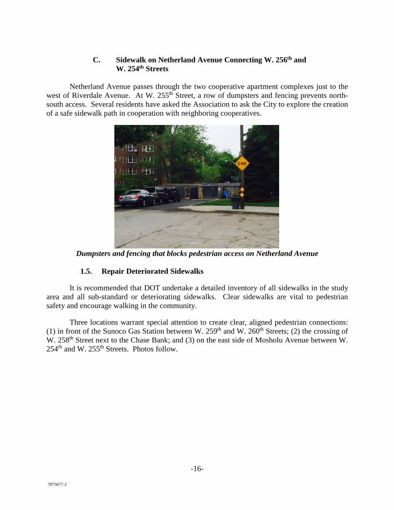
C. Sidewalk on Netherland Avenue Connecting W. 256th and
W. 254th Streets
Netherland Avenue passes through the two cooperative apartment complexes just to the west of Riverdale Avenue. At W. 255th Street, a row of dumpsters and fencing prevents north-south access. Several residents have asked the Association to ask the City to explore the creation of a safe sidewalk path in cooperation with neighboring cooperatives.
Dumpsters and fencing that blocks pedestrian access on Netherland Avenue
1.5. Repair Deteriorated Sidewalks
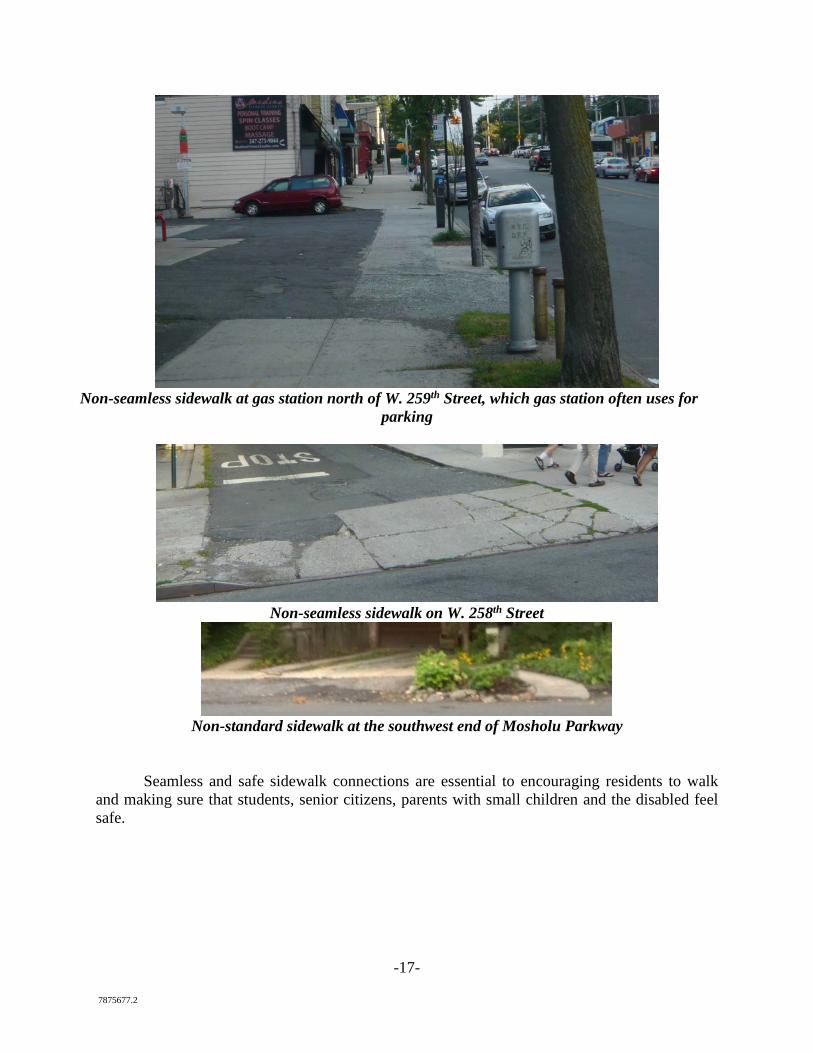
It is recommended that DOT undertake a detailed inventory of all sidewalks in the study area and all sub-standard or deteriorating sidewalks. Clear sidewalks are vital to pedestrian safety and encourage walking in the community.
Three locations warrant special attention to create clear, aligned pedestrian connections: (1) in front of the Sunoco Gas Station between W. 259th and W. 260th Streets; (2) the crossing of W. 258th Street next to the Chase Bank; and (3) on the east side of Mosholu Avenue between W. 254th and W. 255th Streets. Photos follow.
-17- 7875677.2
Non-seamless sidewalk at gas station north of W. 259th Street, which gas station often uses for
parking
Non-seamless sidewalk on W. 258th Street
Non-standard sidewalk at the southwest end of Mosholu Parkway
Seamless and safe sidewalk connections are essential to encouraging residents to walk and making sure that students, senior citizens, parents with small children and the disabled feel safe.
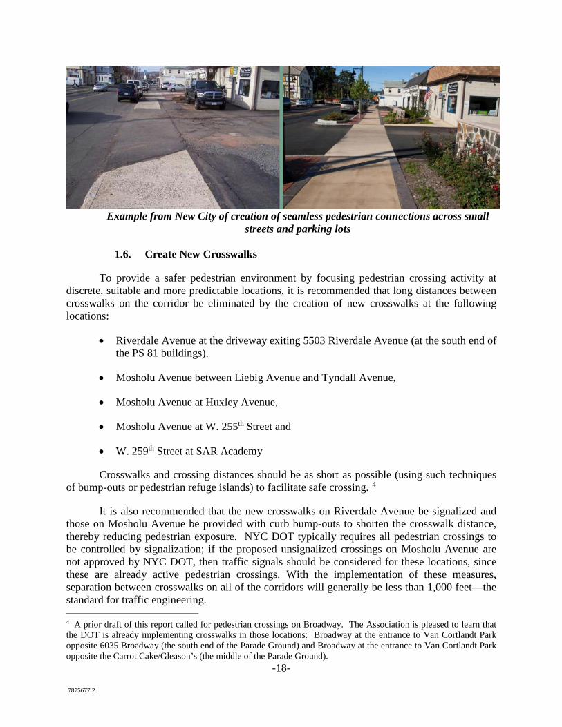
-18- 7875677.2
Example from New City of creation of seamless pedestrian connections across small
streets and parking lots
1.6. Create New Crosswalks
To provide a safer pedestrian environment by focusing pedestrian crossing activity at discrete, suitable and more predictable locations, it is recommended that long distances between crosswalks on the corridor be eliminated by the creation of new crosswalks at the following locations:
• Riverdale Avenue at the driveway exiting 5503 Riverdale Avenue (at the south end of the PS 81 buildings),
• Mosholu Avenue between Liebig Avenue and Tyndall Avenue,
• Mosholu Avenue at Huxley Avenue,
• Mosholu Avenue at W. 255th Street and
• W. 259th Street at SAR Academy
Crosswalks and crossing distances should be as short as possible (using such techniques of bump-outs or pedestrian refuge islands) to facilitate safe crossing. 4
It is also recommended that the new crosswalks on Riverdale Avenue be signalized and those on Mosholu Avenue be provided with curb bump-outs to shorten the crosswalk distance, thereby reducing pedestrian exposure. NYC DOT typically requires all pedestrian crossings to be controlled by signalization; if the proposed unsignalized crossings on Mosholu Avenue are not approved by NYC DOT, then traffic signals should be considered for these locations, since these are already active pedestrian crossings. With the implementation of these measures, separation between crosswalks on all of the corridors will generally be less than 1,000 feet—the standard for traffic engineering. 4 A prior draft of this report called for pedestrian crossings on Broadway. The Association is pleased to learn that the DOT is already implementing crosswalks in those locations: Broadway at the entrance to Van Cortlandt Park opposite 6035 Broadway (the south end of the Parade Ground) and Broadway at the entrance to Van Cortlandt Park opposite the Carrot Cake/Gleason’s (the middle of the Parade Ground).
-19- 7875677.2
-20- 7875677.2
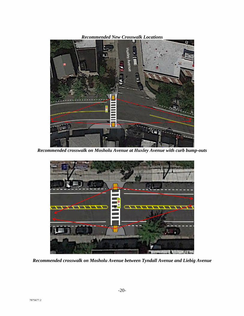
Recommended New Crosswalk Locations
Recommended crosswalk on Mosholu Avenue at Huxley Avenue with curb bump-outs
Recommended crosswalk on Mosholu Avenue between Tyndall Avenue and Liebig Avenue
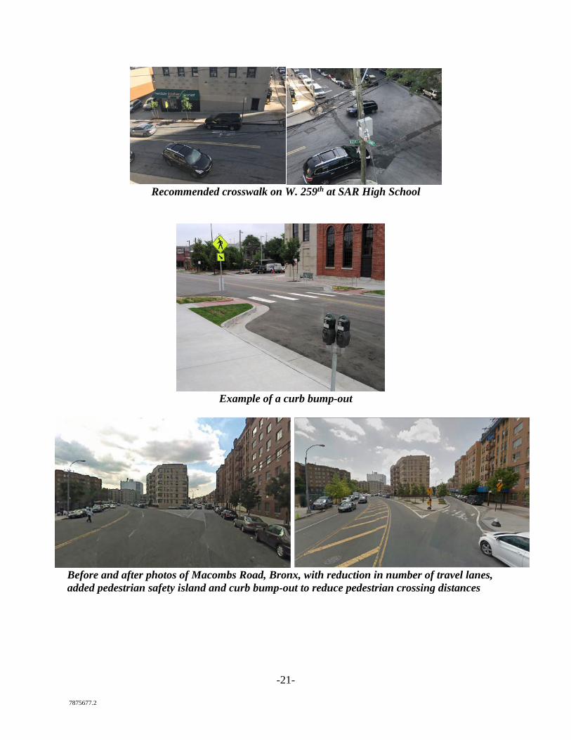
-21- 7875677.2
Recommended crosswalk on W. 259th at SAR High School
Example of a curb bump-out
Before and after photos of Macombs Road, Bronx, with reduction in number of travel lanes, added pedestrian safety island and curb bump-out to reduce pedestrian crossing distances
-22- 7875677.2
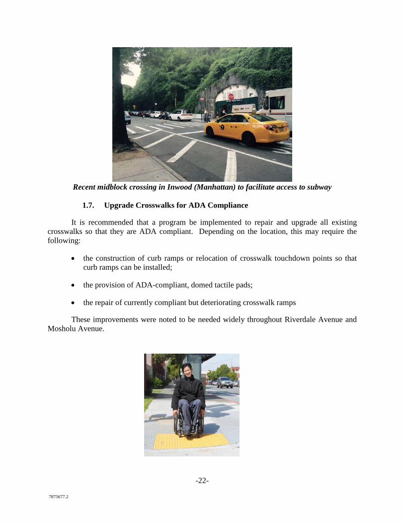
Recent midblock crossing in Inwood (Manhattan) to facilitate access to subway
1.7. Upgrade Crosswalks for ADA Compliance
It is recommended that a program be implemented to repair and upgrade all existing crosswalks so that they are ADA compliant. Depending on the location, this may require the following:
• the construction of curb ramps or relocation of crosswalk touchdown points so that curb ramps can be installed;
• the provision of ADA-compliant, domed tactile pads;
• the repair of currently compliant but deteriorating crosswalk ramps
These improvements were noted to be needed widely throughout Riverdale Avenue and Mosholu Avenue.
-23- 7875677.2
Upgrades leading into Skyview Shopping Center and crossing W. 258th Street are particularly vital.
1.8. Install Pedestrian Countdown Signals
To provide pedestrians with more information, thereby facilitating pedestrian crossing of Riverdale Avenue, it is recommended that a program be implemented to replace existing HAND/MAN pedestrian signal indications with COUNTDOWN pedestrian signal indications. As new traffic signal equipment is rolled out, it is recommended that ADA-compliant pedestrian push buttons be installed.
1.9. Create New Pedestrian Refuge Areas
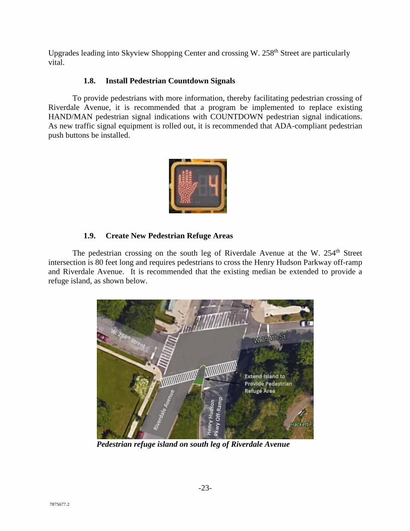
The pedestrian crossing on the south leg of Riverdale Avenue at the W. 254th Street intersection is 80 feet long and requires pedestrians to cross the Henry Hudson Parkway off-ramp and Riverdale Avenue. It is recommended that the existing median be extended to provide a refuge island, as shown below.
Pedestrian refuge island on south leg of Riverdale Avenue
-24- 7875677.2
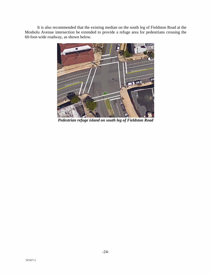
It is also recommended that the existing median on the south leg of Fieldston Road at the Mosholu Avenue intersection be extended to provide a refuge area for pedestrians crossing the 60-foot-wide roadway, as shown below.
Pedestrian refuge island on south leg of Fieldston Road
-25- 7875677.2
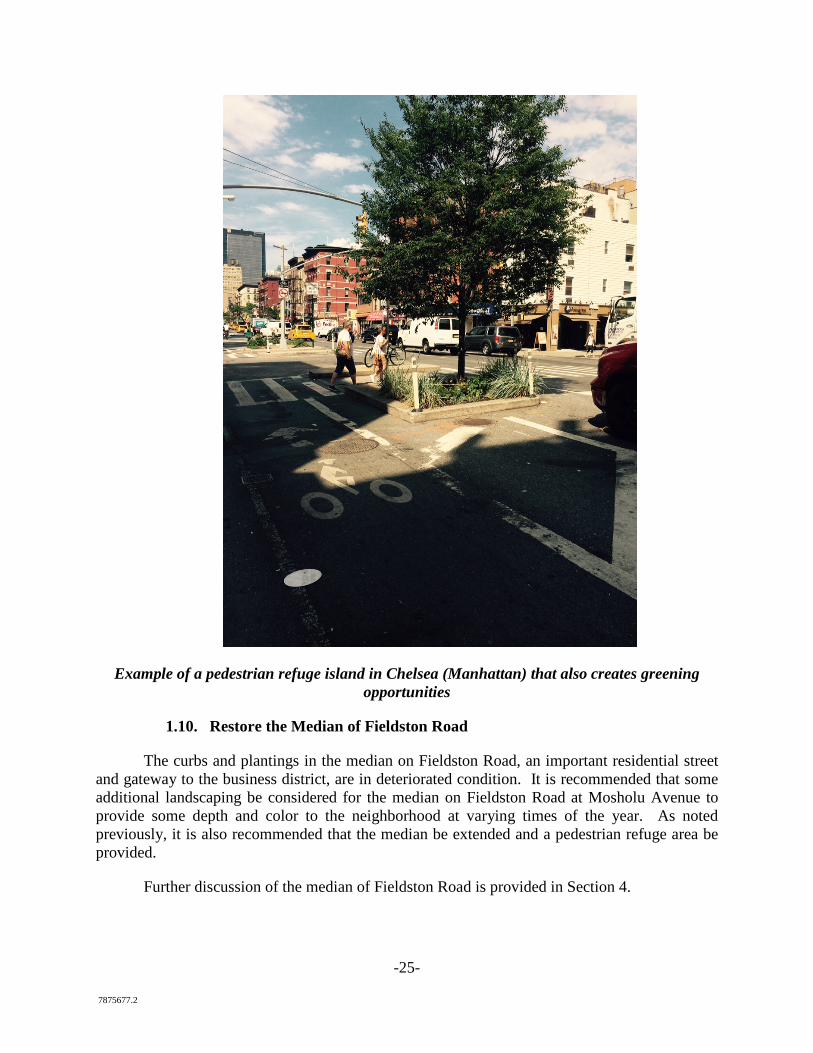
Example of a pedestrian refuge island in Chelsea (Manhattan) that also creates greening opportunities
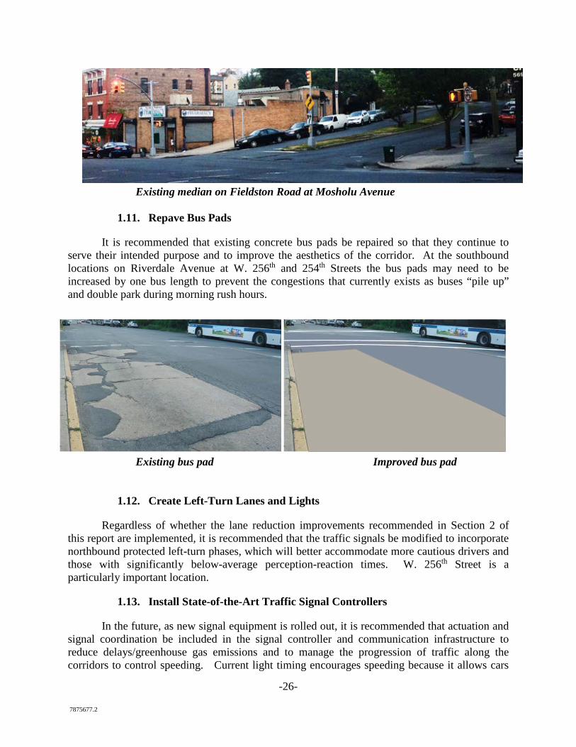
1.10. Restore the Median of Fieldston Road
The curbs and plantings in the median on Fieldston Road, an important residential street and gateway to the business district, are in deteriorated condition. It is recommended that some additional landscaping be considered for the median on Fieldston Road at Mosholu Avenue to provide some depth and color to the neighborhood at varying times of the year. As noted previously, it is also recommended that the median be extended and a pedestrian refuge area be provided.
Further discussion of the median of Fieldston Road is provided in Section 4.
-26- 7875677.2
Existing median on Fieldston Road at Mosholu Avenue
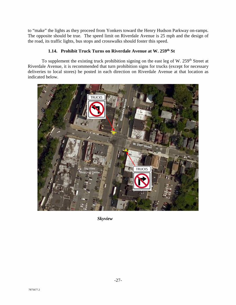
1.11. Repave Bus Pads
It is recommended that existing concrete bus pads be repaired so that they continue to serve their intended purpose and to improve the aesthetics of the corridor. At the southbound locations on Riverdale Avenue at W. 256th and 254th Streets the bus pads may need to be increased by one bus length to prevent the congestions that currently exists as buses “pile up” and double park during morning rush hours.
Existing bus pad Improved bus pad
1.12. Create Left-Turn Lanes and Lights
Regardless of whether the lane reduction improvements recommended in Section 2 of this report are implemented, it is recommended that the traffic signals be modified to incorporate northbound protected left-turn phases, which will better accommodate more cautious drivers and those with significantly below-average perception-reaction times. W. 256th Street is a particularly important location.
1.13. Install State-of-the-Art Traffic Signal Controllers
In the future, as new signal equipment is rolled out, it is recommended that actuation and signal coordination be included in the signal controller and communication infrastructure to reduce delays/greenhouse gas emissions and to manage the progression of traffic along the corridors to control speeding. Current light timing encourages speeding because it allows cars
-27- 7875677.2
to “make” the lights as they proceed from Yonkers toward the Henry Hudson Parkway on-ramps. The opposite should be true. The speed limit on Riverdale Avenue is 25 mph and the design of the road, its traffic lights, bus stops and crosswalks should foster this speed.
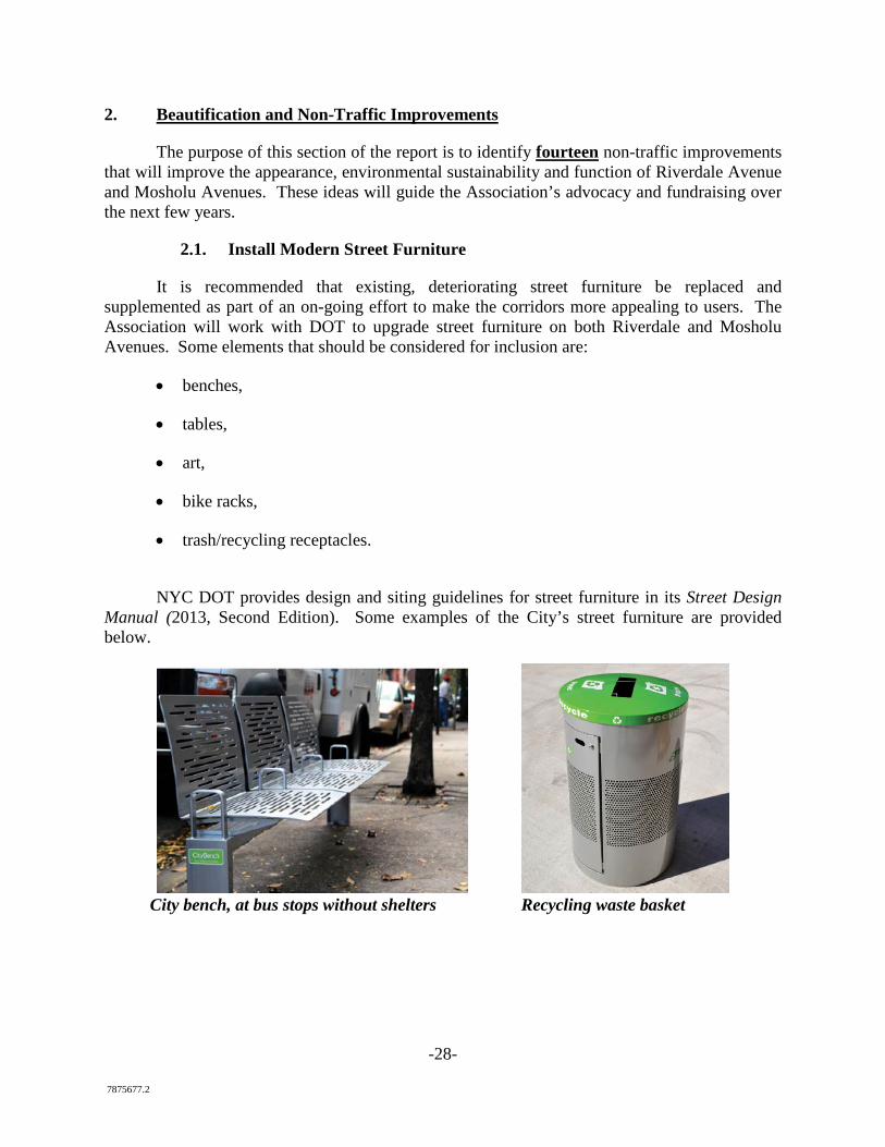
1.14. Prohibit Truck Turns on Riverdale Avenue at W. 259th St
To supplement the existing truck prohibition signing on the east leg of W. 259th Street at Riverdale Avenue, it is recommended that turn prohibition signs for trucks (except for necessary deliveries to local stores) be posted in each direction on Riverdale Avenue at that location as indicated below.
Skyview
-28- 7875677.2
2. Beautification and Non-Traffic Improvements
The purpose of this section of the report is to identify fourteen non-traffic improvements that will improve the appearance, environmental sustainability and function of Riverdale Avenue and Mosholu Avenues. These ideas will guide the Association’s advocacy and fundraising over the next few years.
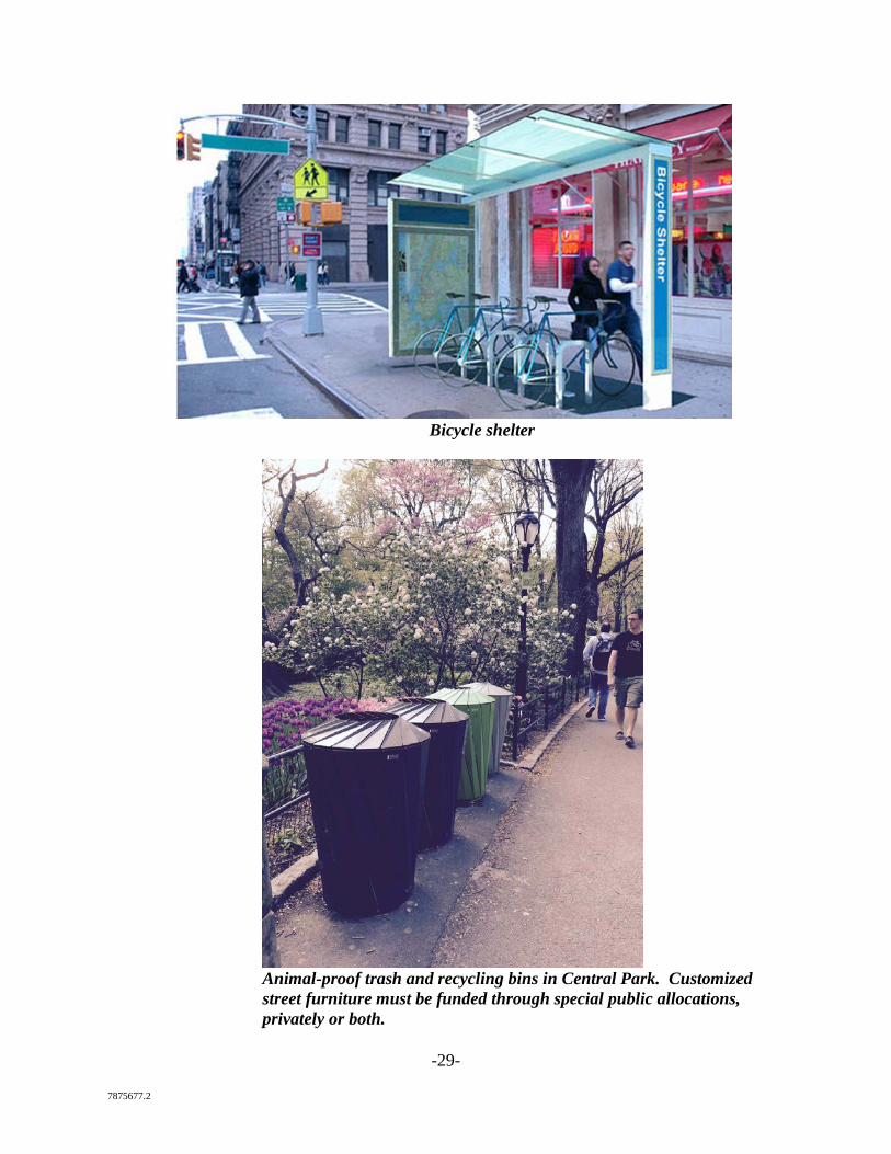
2.1. Install Modern Street Furniture
It is recommended that existing, deteriorating street furniture be replaced and supplemented as part of an on-going effort to make the corridors more appealing to users. The Association will work with DOT to upgrade street furniture on both Riverdale and Mosholu Avenues. Some elements that should be considered for inclusion are:
• benches,
• tables,
• art,
• bike racks,
• trash/recycling receptacles.
NYC DOT provides design and siting guidelines for street furniture in its Street Design
Manual (2013, Second Edition). Some examples of the City’s street furniture are provided below.
City bench, at bus stops without shelters Recycling waste basket
-29- 7875677.2
Bicycle shelter
Animal-proof trash and recycling bins in Central Park. Customized street furniture must be funded through special public allocations, privately or both.
-30- 7875677.2
2.2. Replace Dead Street Trees
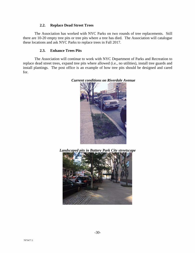
The Association has worked with NYC Parks on two rounds of tree replacements. Still there are 10-20 empty tree pits or tree pits where a tree has died. The Association will catalogue these locations and ask NYC Parks to replace trees in Fall 2017.
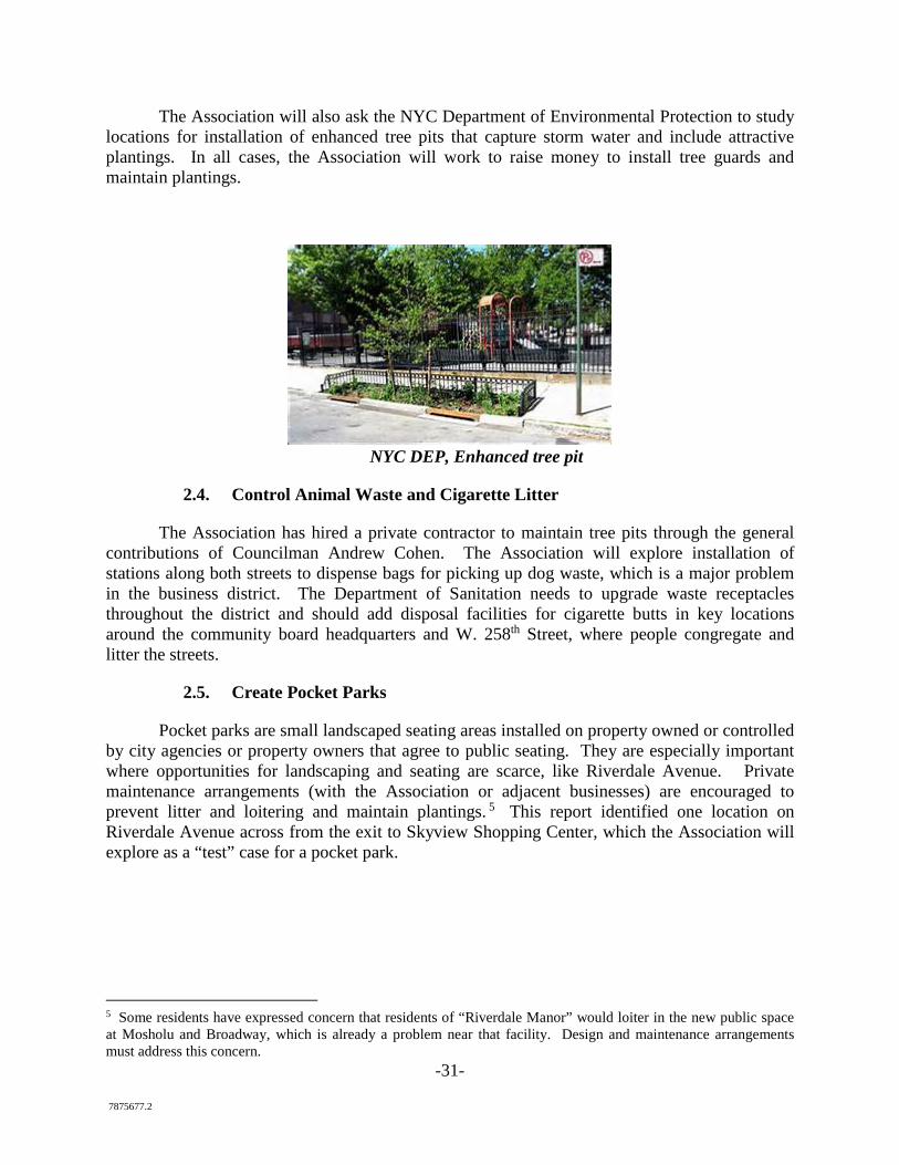
2.3. Enhance Trees Pits
The Association will continue to work with NYC Department of Parks and Recreation to replace dead street trees, expand tree pits where allowed (i.e., no utilities), install tree guards and install plantings. The post office is an example of how tree pits should be designed and cared for.
Current conditions on Riverdale Avenue
Landscaped pits in Battery Park City streetscape
-31- 7875677.2
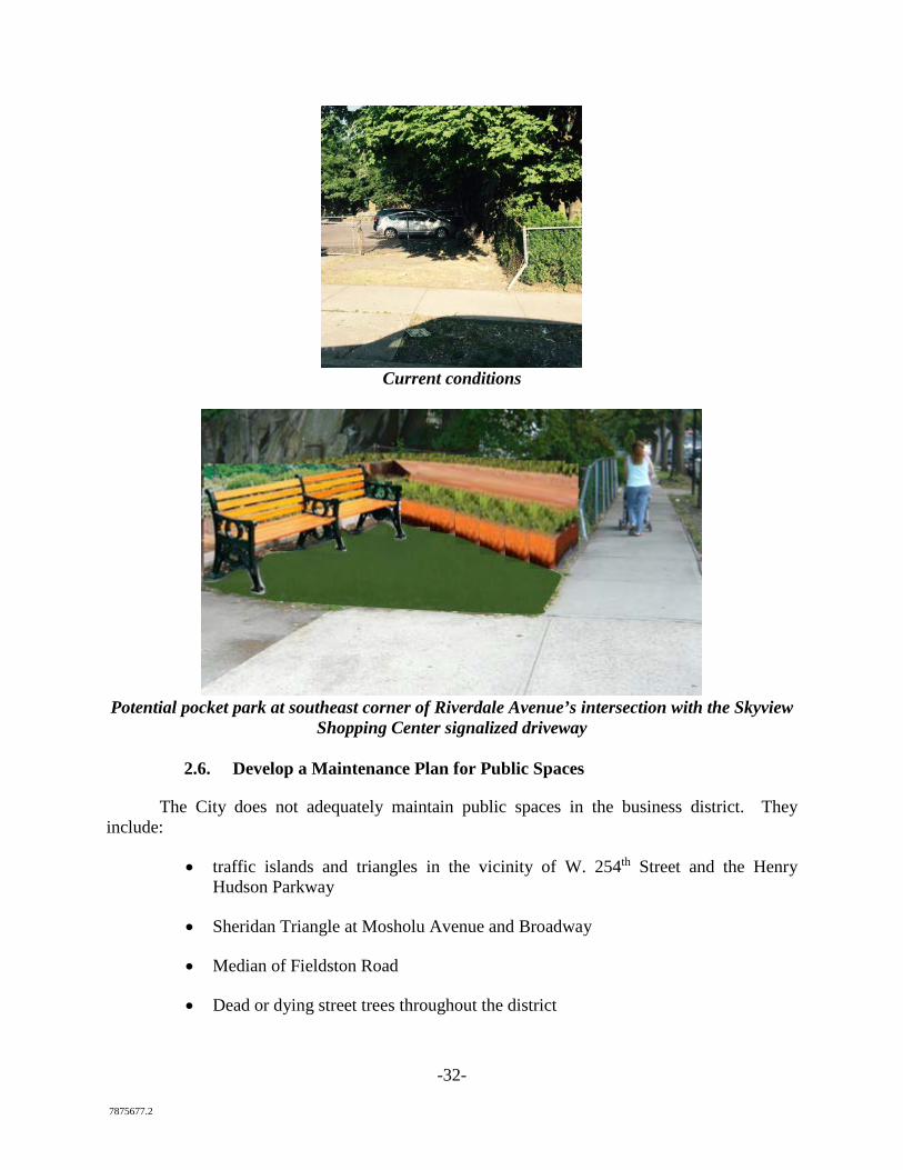
The Association will also ask the NYC Department of Environmental Protection to study locations for installation of enhanced tree pits that capture storm water and include attractive plantings. In all cases, the Association will work to raise money to install tree guards and maintain plantings.
NYC DEP, Enhanced tree pit
2.4. Control Animal Waste and Cigarette Litter
The Association has hired a private contractor to maintain tree pits through the general contributions of Councilman Andrew Cohen. The Association will explore installation of stations along both streets to dispense bags for picking up dog waste, which is a major problem in the business district. The Department of Sanitation needs to upgrade waste receptacles throughout the district and should add disposal facilities for cigarette butts in key locations around the community board headquarters and W. 258th Street, where people congregate and litter the streets.
2.5. Create Pocket Parks
Pocket parks are small landscaped seating areas installed on property owned or controlled by city agencies or property owners that agree to public seating. They are especially important where opportunities for landscaping and seating are scarce, like Riverdale Avenue. Private maintenance arrangements (with the Association or adjacent businesses) are encouraged to prevent litter and loitering and maintain plantings. 5 This report identified one location on Riverdale Avenue across from the exit to Skyview Shopping Center, which the Association will explore as a “test” case for a pocket park.
5 Some residents have expressed concern that residents of “Riverdale Manor” would loiter in the new public space at Mosholu and Broadway, which is already a problem near that facility. Design and maintenance arrangements must address this concern.
-32- 7875677.2
Current conditions
Potential pocket park at southeast corner of Riverdale Avenue’s intersection with the Skyview
Shopping Center signalized driveway
2.6. Develop a Maintenance Plan for Public Spaces
The City does not adequately maintain public spaces in the business district. They include:
• traffic islands and triangles in the vicinity of W. 254th Street and the Henry Hudson Parkway
• Sheridan Triangle at Mosholu Avenue and Broadway
• Median of Fieldston Road
• Dead or dying street trees throughout the district
-33- 7875677.2
Maintenance shortcomings are very basic—grass needs to be mowed and trees pruned. The Association will advocate with DOT and NYC Parks to ensure weekly maintenance of these spaces, which serve as the three primary gateways into the heart of Riverdale. On a longer term basis, the Association will seek funding to help carry out maintenance duties itself.
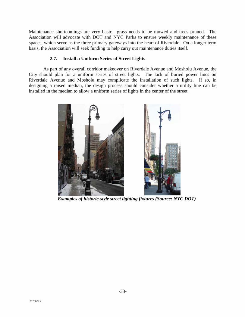
2.7. Install a Uniform Series of Street Lights
As part of any overall corridor makeover on Riverdale Avenue and Mosholu Avenue, the City should plan for a uniform series of street lights. The lack of buried power lines on Riverdale Avenue and Mosholu may complicate the installation of such lights. If so, in designing a raised median, the design process should consider whether a utility line can be installed in the median to allow a uniform series of lights in the center of the street.
Examples of historic-style street lighting fixtures (Source: NYC DOT)
-34- 7875677.2
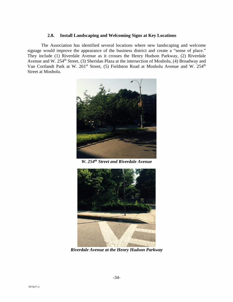
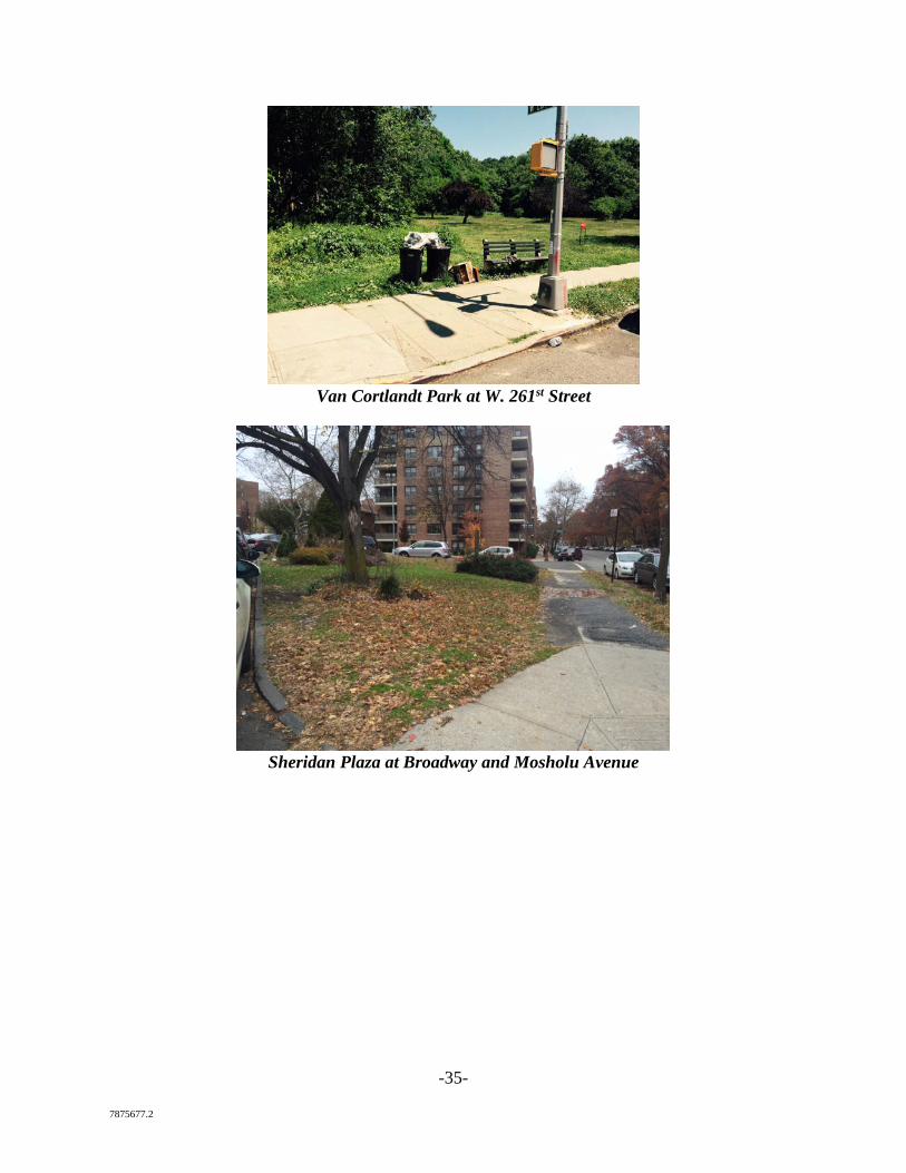
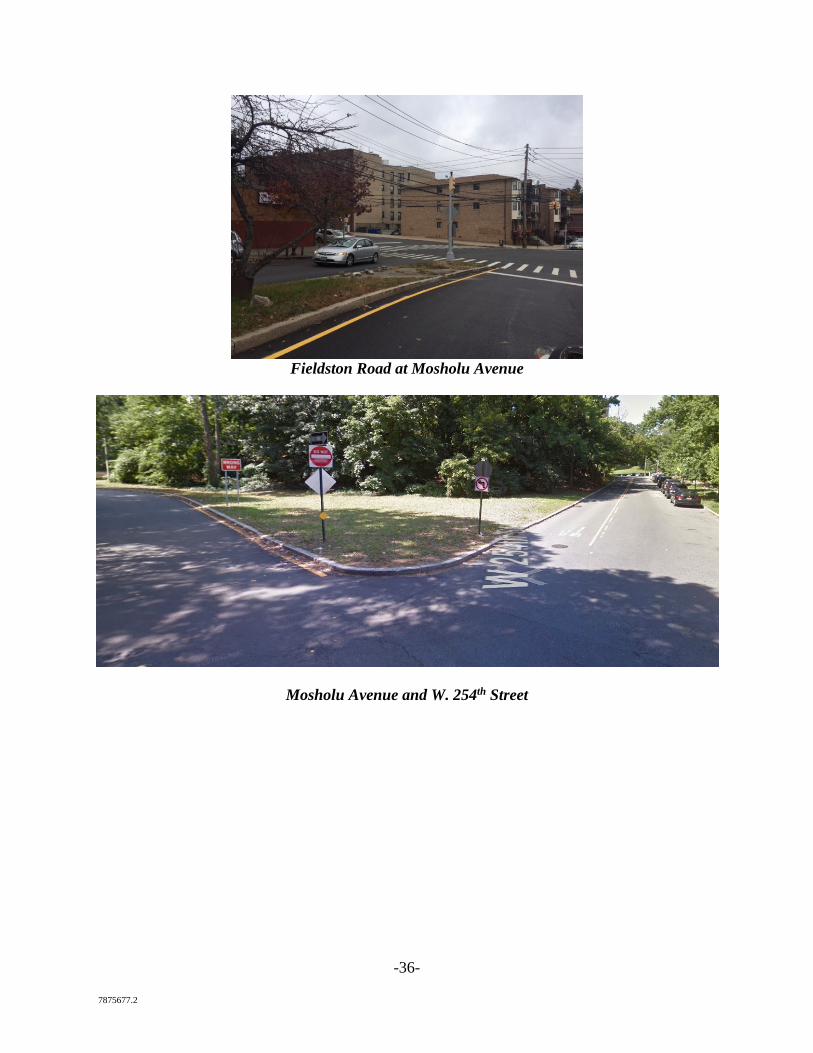
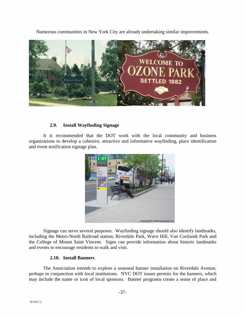
2.8. Install Landscaping and Welcoming Signs at Key Locations
The Association has identified several locations where new landscaping and welcome signage would improve the appearance of the business district and create a “sense of place.” They include (1) Riverdale Avenue as it crosses the Henry Hudson Parkway, (2) Riverdale Avenue and W. 254th Street, (3) Sheridan Plaza at the intersection of Mosholu, (4) Broadway and Van Cortlandt Park at W. 261st Street, (5) Fieldston Road at Mosholu Avenue and W. 254th Street at Mosholu.
W. 254th Street and Riverdale Avenue
Riverdale Avenue at the Henry Hudson Parkway
-35- 7875677.2
Van Cortlandt Park at W. 261st Street
Sheridan Plaza at Broadway and Mosholu Avenue
-36- 7875677.2
Fieldston Road at Mosholu Avenue
Mosholu Avenue and W. 254th Street
-37- 7875677.2
Numerous communities in New York City are already undertaking similar improvements.
2.9. Install Wayfinding Signage
It is recommended that the DOT work with the local community and business organizations to develop a cohesive, attractive and informative wayfinding, place identification and event notification signage plan.
Signage can serve several purposes. Wayfinding signage should also identify landmarks, including the Metro-North Railroad station, Riverdale Park, Wave Hill, Van Cortlandt Park and the College of Mount Saint Vincent. Signs can provide information about historic landmarks and events to encourage residents to walk and visit.
2.10. Install Banners
The Association intends to explore a seasonal banner installation on Riverdale Avenue, perhaps in conjunction with local institutions. NYC DOT issues permits for the banners, which may include the name or icon of local sponsors. Banner programs create a sense of place and
-38- 7875677.2
help beautify business districts, especially early in revitalization programs when capital projects have not yet been funded.
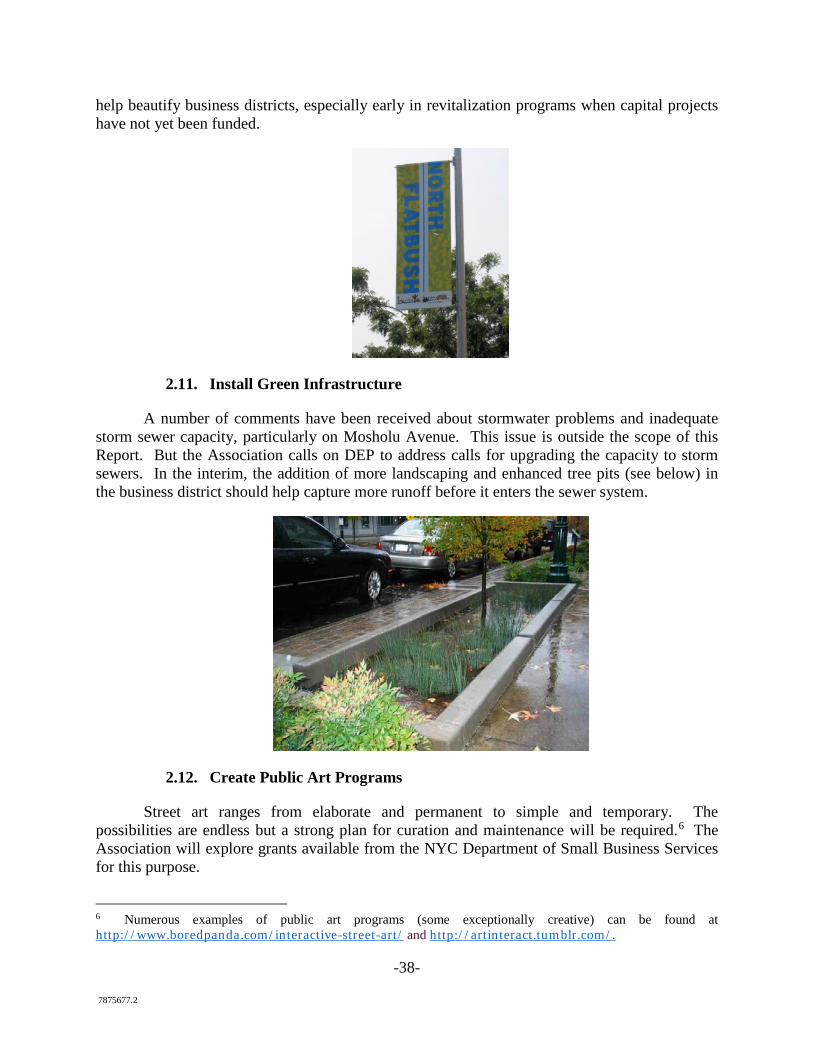
2.11. Install Green Infrastructure
A number of comments have been received about stormwater problems and inadequate storm sewer capacity, particularly on Mosholu Avenue. This issue is outside the scope of this Report. But the Association calls on DEP to address calls for upgrading the capacity to storm sewers. In the interim, the addition of more landscaping and enhanced tree pits (see below) in the business district should help capture more runoff before it enters the sewer system.
2.12. Create Public Art Programs
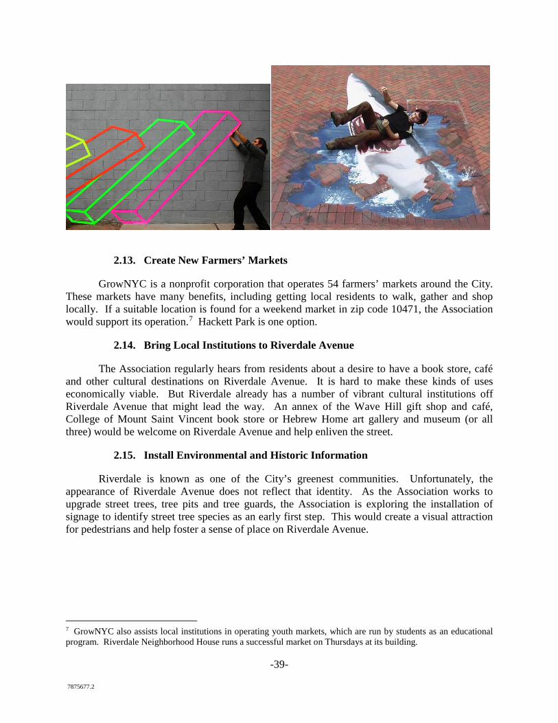
Street art ranges from elaborate and permanent to simple and temporary. The possibilities are endless but a strong plan for curation and maintenance will be required.6 The Association will explore grants available from the NYC Department of Small Business Services for this purpose.
6 Numerous examples of public art programs (some exceptionally creative) can be found at http://www.boredpanda.com/interactive-street-art/ and http://artinteract.tumblr.com/.
-39- 7875677.2
2.13. Create New Farmers’ Markets
GrowNYC is a nonprofit corporation that operates 54 farmers’ markets around the City. These markets have many benefits, including getting local residents to walk, gather and shop locally. If a suitable location is found for a weekend market in zip code 10471, the Association would support its operation.7 Hackett Park is one option.
2.14. Bring Local Institutions to Riverdale Avenue
The Association regularly hears from residents about a desire to have a book store, café and other cultural destinations on Riverdale Avenue. It is hard to make these kinds of uses economically viable. But Riverdale already has a number of vibrant cultural institutions off Riverdale Avenue that might lead the way. An annex of the Wave Hill gift shop and café, College of Mount Saint Vincent book store or Hebrew Home art gallery and museum (or all three) would be welcome on Riverdale Avenue and help enliven the street.
2.15. Install Environmental and Historic Information
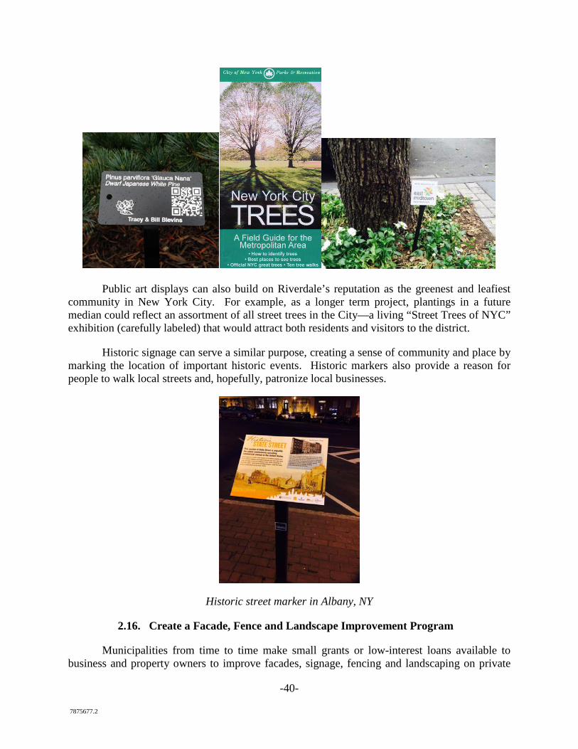
Riverdale is known as one of the City’s greenest communities. Unfortunately, the appearance of Riverdale Avenue does not reflect that identity. As the Association works to upgrade street trees, tree pits and tree guards, the Association is exploring the installation of signage to identify street tree species as an early first step. This would create a visual attraction for pedestrians and help foster a sense of place on Riverdale Avenue.
7 GrowNYC also assists local institutions in operating youth markets, which are run by students as an educational program. Riverdale Neighborhood House runs a successful market on Thursdays at its building.
-40- 7875677.2
Public art displays can also build on Riverdale’s reputation as the greenest and leafiest community in New York City. For example, as a longer term project, plantings in a future median could reflect an assortment of all street trees in the City—a living “Street Trees of NYC” exhibition (carefully labeled) that would attract both residents and visitors to the district.
Historic signage can serve a similar purpose, creating a sense of community and place by marking the location of important historic events. Historic markers also provide a reason for people to walk local streets and, hopefully, patronize local businesses.
Historic street marker in Albany, NY
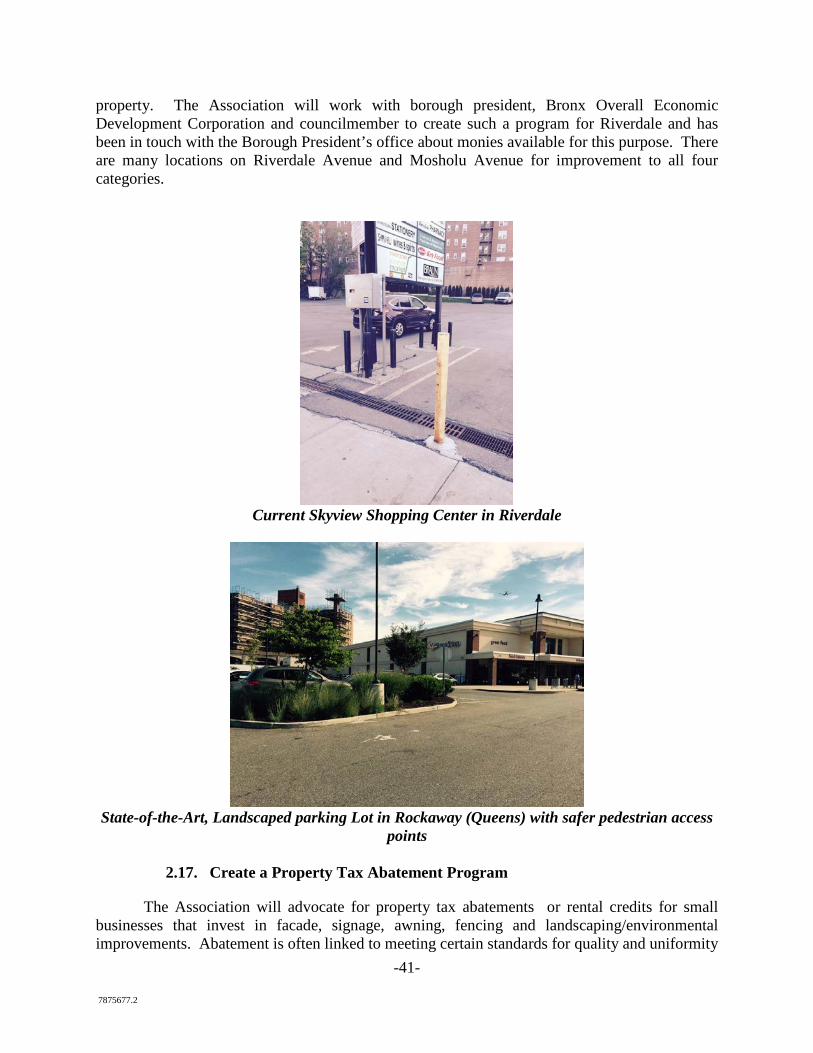
2.16. Create a Facade, Fence and Landscape Improvement Program
Municipalities from time to time make small grants or low-interest loans available to business and property owners to improve facades, signage, fencing and landscaping on private
-41- 7875677.2
property. The Association will work with borough president, Bronx Overall Economic Development Corporation and councilmember to create such a program for Riverdale and has been in touch with the Borough President’s office about monies available for this purpose. There are many locations on Riverdale Avenue and Mosholu Avenue for improvement to all four categories.
Current Skyview Shopping Center in Riverdale
State-of-the-Art, Landscaped parking Lot in Rockaway (Queens) with safer pedestrian access
points
2.17. Create a Property Tax Abatement Program
The Association will advocate for property tax abatements or rental credits for small businesses that invest in facade, signage, awning, fencing and landscaping/environmental improvements. Abatement is often linked to meeting certain standards for quality and uniformity
-42- 7875677.2
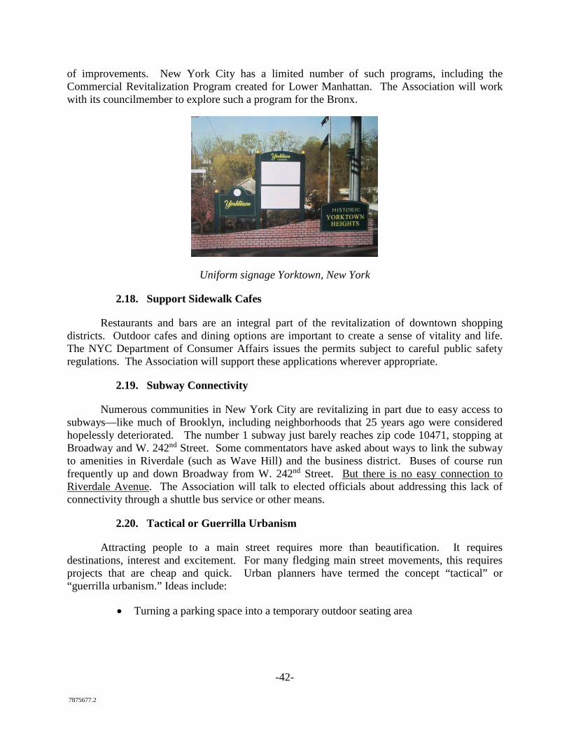
of improvements. New York City has a limited number of such programs, including the Commercial Revitalization Program created for Lower Manhattan. The Association will work with its councilmember to explore such a program for the Bronx.
Uniform signage Yorktown, New York
2.18. Support Sidewalk Cafes
Restaurants and bars are an integral part of the revitalization of downtown shopping districts. Outdoor cafes and dining options are important to create a sense of vitality and life. The NYC Department of Consumer Affairs issues the permits subject to careful public safety regulations. The Association will support these applications wherever appropriate.
2.19. Subway Connectivity
Numerous communities in New York City are revitalizing in part due to easy access to subways—like much of Brooklyn, including neighborhoods that 25 years ago were considered hopelessly deteriorated. The number 1 subway just barely reaches zip code 10471, stopping at Broadway and W. 242nd Street. Some commentators have asked about ways to link the subway to amenities in Riverdale (such as Wave Hill) and the business district. Buses of course run frequently up and down Broadway from W. 242nd Street. But there is no easy connection to Riverdale Avenue. The Association will talk to elected officials about addressing this lack of connectivity through a shuttle bus service or other means.
2.20. Tactical or Guerrilla Urbanism
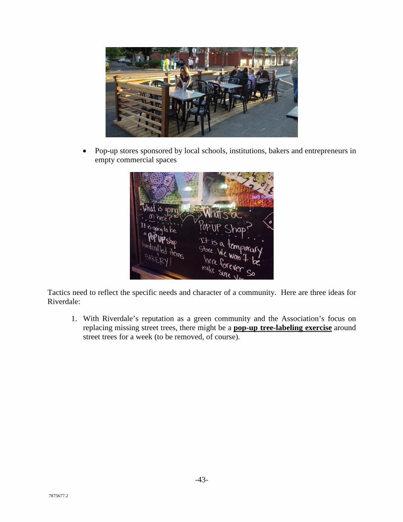
Attracting people to a main street requires more than beautification. It requires destinations, interest and excitement. For many fledging main street movements, this requires projects that are cheap and quick. Urban planners have termed the concept “tactical” or “guerrilla urbanism.” Ideas include:
• Turning a parking space into a temporary outdoor seating area
-43- 7875677.2
• Pop-up stores sponsored by local schools, institutions, bakers and entrepreneurs in empty commercial spaces
Tactics need to reflect the specific needs and character of a community. Here are three ideas for Riverdale:
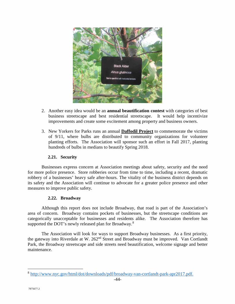
1. With Riverdale’s reputation as a green community and the Association’s focus on replacing missing street trees, there might be a pop-up tree-labeling exercise around street trees for a week (to be removed, of course).
-44- 7875677.2
2. Another easy idea would be an annual beautification contest with categories of best business streetscape and best residential streetscape. It would help incentivize improvements and create some excitement among property and business owners.
3. New Yorkers for Parks runs an annual Daffodil Project to commemorate the victims of 9/11, where bulbs are distributed to community organizations for volunteer planting efforts. The Association will sponsor such an effort in Fall 2017, planting hundreds of bulbs in medians to beautify Spring 2018.
2.21. Security
Businesses express concern at Association meetings about safety, security and the need for more police presence. Store robberies occur from time to time, including a recent, dramatic robbery of a businesses’ heavy safe after-hours. The vitality of the business district depends on its safety and the Association will continue to advocate for a greater police presence and other measures to improve public safety.
2.22. Broadway
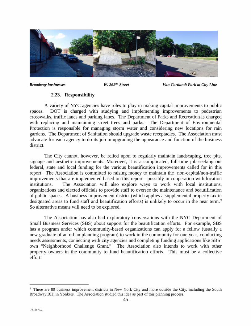
Although this report does not include Broadway, that road is part of the Association’s area of concern. Broadway contains pockets of businesses, but the streetscape conditions are categorically unacceptable for businesses and residents alike. The Association therefore has supported the DOT’s newly released plan for Broadway.8
The Association will look for ways to support Broadway businesses. As a first priority, the gateway into Riverdale at W. 262nd Street and Broadway must be improved. Van Cortlandt Park, the Broadway streetscape and side streets need beautification, welcome signage and better maintenance.
8 http://www.nyc.gov/html/dot/downloads/pdf/broadway-van-cortlandt-park-apr2017.pdf.
-45- 7875677.2
Broadway businesses W. 262nd Street Van Cortlandt Park at City Line
2.23. Responsibility
A variety of NYC agencies have roles to play in making capital improvements to public spaces. DOT is charged with studying and implementing improvements to pedestrian crosswalks, traffic lanes and parking lanes. The Department of Parks and Recreation is charged with replacing and maintaining street trees and parks. The Department of Environmental Protection is responsible for managing storm water and considering new locations for rain gardens. The Department of Sanitation should upgrade waste receptacles. The Association must advocate for each agency to do its job in upgrading the appearance and function of the business district.
The City cannot, however, be relied upon to regularly maintain landscaping, tree pits, signage and aesthetic improvements. Moreover, it is a complicated, full-time job seeking out federal, state and local funding for the various beautification improvements called for in this report. The Association is committed to raising money to maintain the non-capital/non-traffic improvements that are implemented based on this report—possibly in cooperation with location institutions. The Association will also explore ways to work with local institutions, organizations and elected officials to provide staff to oversee the maintenance and beautification of public spaces. A business improvement district (which applies a supplemental property tax in designated areas to fund staff and beautification efforts) is unlikely to occur in the near term.9 So alternative means will need to be explored.
The Association has also had exploratory conversations with the NYC Department of Small Business Services (SBS) about support for the beautification efforts. For example, SBS has a program under which community-based organizations can apply for a fellow (usually a new graduate of an urban planning program) to work in the community for one year, conducting needs assessments, connecting with city agencies and completing funding applications like SBS’ own “Neighborhood Challenge Grant.” The Association also intends to work with other property owners in the community to fund beautification efforts. This must be a collective effort.
9 There are 80 business improvement districts in New York City and more outside the City, including the South Broadway BID in Yonkers. The Association studied this idea as part of this planning process.
-46- 7875677.2
3. Request to DOT to Study Traffic Calming and Pedestrian, Motorist and Parking Safety
The purpose of section 3 of this report is to outline six traffic improvement ideas that VHB Engineering has identified as having the highest potential for slowing traffic, improving function and preventing accidents, fatalities and injuries. These ideas are intended to be suggestions for study and are not all-inclusive of other ideas DOT might develop in consultation with the community. The Association is not recommending any particular set of improvements and will reserve its recommendations for after DOT study and community consultation. The Association asks DOT to carry out that process, however, during 2017 and 2018.10
One of the principal concerns expressed by stakeholders is that vehicles routinely and significantly exceed the posted 25 mph speed limits in the study area, and that speeding detracts from the corridor’s safety as well as the quality of life on the corridors. The primary goal of traffic calming measures should be to reduce speeds along the corridors to the posted limit of 25 mph. Beyond safety, legal traffic flow would improve the environment of Riverdale Avenue for those patronizing its stores, institutions and schools—a primary concern of the Association.
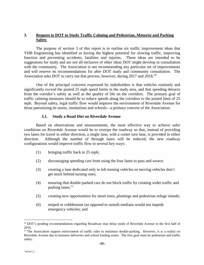
3.1. Study a Road Diet on Riverdale Avenue
Based on observations and measurements, the most effective way to achieve safer conditions on Riverdale Avenue would be to restripe the roadway so that, instead of providing two lanes for travel in either direction, a single lane, with a center turn lane, is provided in either direction. Although the number of through lanes will be reduced, the new roadway configurations would improve traffic flow in several key ways:
(1) bringing traffic back to 25 mph;
(2) discouraging speeding cars from using the four lanes to pass and weave;
(3) creating a lane dedicated only to left-turning vehicles so moving vehicles don’t get stuck behind turning ones;
(4) ensuring that double-parked cars do not block traffic by creating wider traffic and parking lanes;11
(5) creating new opportunities for street trees, plantings and pedestrian refuge islands;
(6) striped or cobblestone (as opposed to raised) medians would not impede emergency vehicles; and
10 DOT’s pending recommendations regarding Broadway may delay study of Riverdale Avenue in the first half of 2016. 11 The Association support enforcement of traffic rules to minimize double-parking. However, it is a reality on Riverdale Avenue due to business deliveries and school loading zones. The first goal must be pedestrian and traffic safety.
-47- 7875677.2
(7) redesign would allow for a parking buffer that lets people avoid stepping into a lane of traffic as they enter and exit parked cars
The current condition, where two lanes are provided in either direction, is problematic because it allows speeders/faster vehicles to pass slower vehicles that may be traveling at or closer to the speed limit. It is also undesirable because it requires left-turning vehicles to stop in the leftmost through lane when waiting for a gap in opposing traffic. This presents a conflict with following through moving vehicles.
This change, sometimes referred to as a “road diet,” often results in both safer and smoother traffic flow. Preliminary analyses indicate that it may be possible to eliminate the second through lane throughout Riverdale Avenue. At one location, VHB recommends DOT do additional analyses to confirm this: Riverdale Avenue at W. 254th Street.12
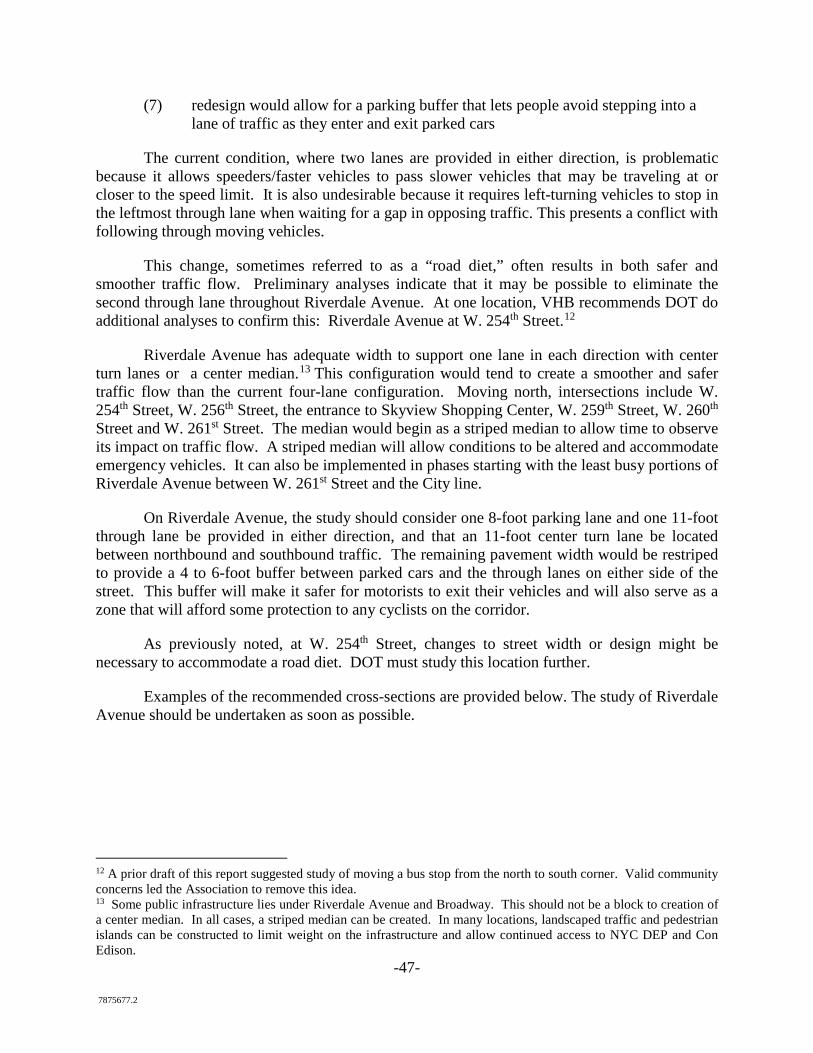
Riverdale Avenue has adequate width to support one lane in each direction with center turn lanes or a center median.13 This configuration would tend to create a smoother and safer traffic flow than the current four-lane configuration. Moving north, intersections include W. 254th Street, W. 256th Street, the entrance to Skyview Shopping Center, W. 259th Street, W. 260th Street and W. 261st Street. The median would begin as a striped median to allow time to observe its impact on traffic flow. A striped median will allow conditions to be altered and accommodate emergency vehicles. It can also be implemented in phases starting with the least busy portions of Riverdale Avenue between W. 261st Street and the City line.
On Riverdale Avenue, the study should consider one 8-foot parking lane and one 11-foot through lane be provided in either direction, and that an 11-foot center turn lane be located between northbound and southbound traffic. The remaining pavement width would be restriped to provide a 4 to 6-foot buffer between parked cars and the through lanes on either side of the street. This buffer will make it safer for motorists to exit their vehicles and will also serve as a zone that will afford some protection to any cyclists on the corridor.
As previously noted, at W. 254th Street, changes to street width or design might be necessary to accommodate a road diet. DOT must study this location further.
Examples of the recommended cross-sections are provided below. The study of Riverdale Avenue should be undertaken as soon as possible.
12 A prior draft of this report suggested study of moving a bus stop from the north to south corner. Valid community concerns led the Association to remove this idea. 13 Some public infrastructure lies under Riverdale Avenue and Broadway. This should not be a block to creation of a center median. In all cases, a striped median can be created. In many locations, landscaped traffic and pedestrian islands can be constructed to limit weight on the infrastructure and allow continued access to NYC DEP and Con Edison.
-48- 7875677.2
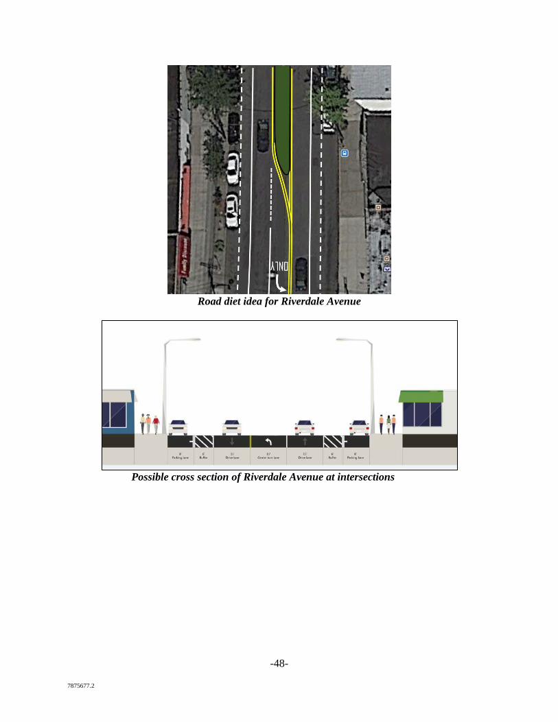
Road diet idea for Riverdale Avenue
Possible cross section of Riverdale Avenue at intersections
-49- 7875677.2
Example of road diet on Allerton Avenue
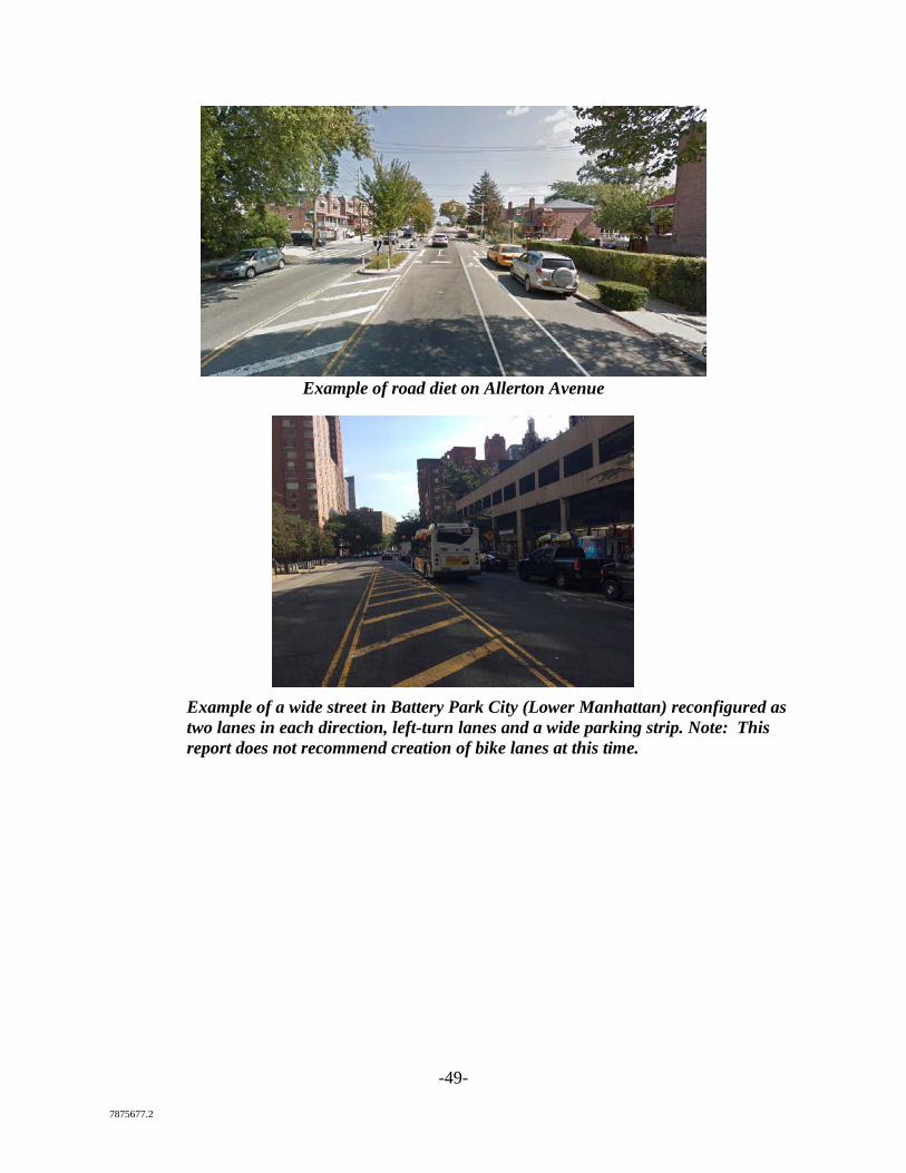
Example of a wide street in Battery Park City (Lower Manhattan) reconfigured as two lanes in each direction, left-turn lanes and a wide parking strip. Note: This report does not recommend creation of bike lanes at this time.
-50- 7875677.2
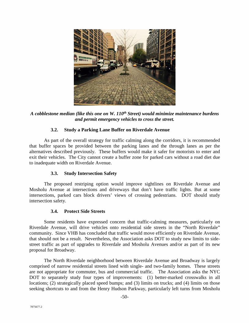
A cobblestone median (like this one on W. 110th Street) would minimize maintenance burdens and permit emergency vehicles to cross the street.
3.2. Study a Parking Lane Buffer on Riverdale Avenue
As part of the overall strategy for traffic calming along the corridors, it is recommended that buffer spaces be provided between the parking lanes and the through lanes as per the alternatives described previously. These buffers would make it safer for motorists to enter and exit their vehicles. The City cannot create a buffer zone for parked cars without a road diet due to inadequate width on Riverdale Avenue.
3.3. Study Intersection Safety
The proposed restriping option would improve sightlines on Riverdale Avenue and Mosholu Avenue at intersections and driveways that don’t have traffic lights. But at some intersections, parked cars block drivers’ views of crossing pedestrians. DOT should study intersection safety.
3.4. Protect Side Streets
Some residents have expressed concern that traffic-calming measures, particularly on Riverdale Avenue, will drive vehicles onto residential side streets in the “North Riverdale” community. Since VHB has concluded that traffic would move efficiently on Riverdale Avenue, that should not be a result. Nevertheless, the Association asks DOT to study new limits to side-street traffic as part of upgrades to Riverdale and Mosholu Avenues and/or as part of its new proposal for Broadway.
The North Riverdale neighborhood between Riverdale Avenue and Broadway is largely comprised of narrow residential streets lined with single- and two-family homes. These streets are not appropriate for commuter, bus and commercial traffic. The Association asks the NYC DOT to separately study four types of improvements: (1) better-marked crosswalks in all locations; (2) strategically placed speed bumps; and (3) limits on trucks; and (4) limits on those seeking shortcuts to and from the Henry Hudson Parkway, particularly left turns from Mosholu
-51- 7875677.2
Avenue onto Tyndall and Liebig Avenues. This study should also look at W. 259th and 261st Streets, which often host commercial cut-through traffic. The intersection of W. 259th Street and Liebig is a particular concern as commercial traffic often (illegally) uses this street and the intersection and pedestrian crossings are poorly aligned. Some residents have also called for study of creating one-way streets in some locations, which is beyond the scope of this particular report.
3.5. Study Student Loading/Unloading Zones at Local Schools
Approximately 1,500 children attend schools located on Riverdale Avenue and another 1,500 students attend the College of Mount Saint Vincent. Little investment has been made in making Riverdale Avenue safe or attractive for these schools or safe for the students, parents and staff relying on the street. Each of the improvements called for in this plan would address these shortcomings. At P.S. 81 and Saint Margaret’s of Cortona School, however, specific improvements should be made to Riverdale Avenue to facilitate pickup and drop-off times. DOT should improve the visibility of school drop-off and pickup areas and enforce regulations to provide a safer school environment. Measures could include the following:
• pavement markings in pick-up/drop off zones,
• expanded hours of no parking during these times,
• exclusive pedestrian signal phasing and countdown pedestrian signal indications,
• the establishment of school speed zones with lower speed limits and flashing beacons.
With regard to school loading, regulations could expand no-parking zones during the hours of loading activity (7:30 to 9:00 a.m. and 2:30 to 4:00 p.m., typically for schools, and before 11:00 a.m., typically for commercial loading activity). For example, along the east side of Riverdale Avenue at Saint Margaret of Cortona School (south of W. 260th Street), the current one-hour parking limit could be modified to provide a no-parking zone during the peak school drop-off and pickup periods. Pavement markings and signage are recommended to delineate the no-parking zones.
Long term, the creation of loading and unloading zones could be established on side streets (W. 256th and W. 260th). W. 260th is already closed at certain times of the day to through traffic for safety reasons.
-52- 7875677.2
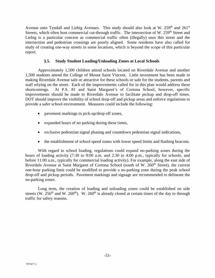
Recommend increased visibility of school drop-off/pickup area on Riverdale Avenue in front of Saint Margaret of Cortona School
Note about the Reconstruction of the Intersection of Broadway with Mosholu Avenue/David Sheridan Plaza:
A prior version of this report asked DOT to study the reconfiguration of the intersection of Mosholu Avenue and Broadway to reduce pedestrian crossing distances and create better public open space. As part of its newly issued Broadway proposal, DOT has undertaken this study. The Association strongly supports these efforts to improve this intersection and is therefore removing its separate recommendation from this report.
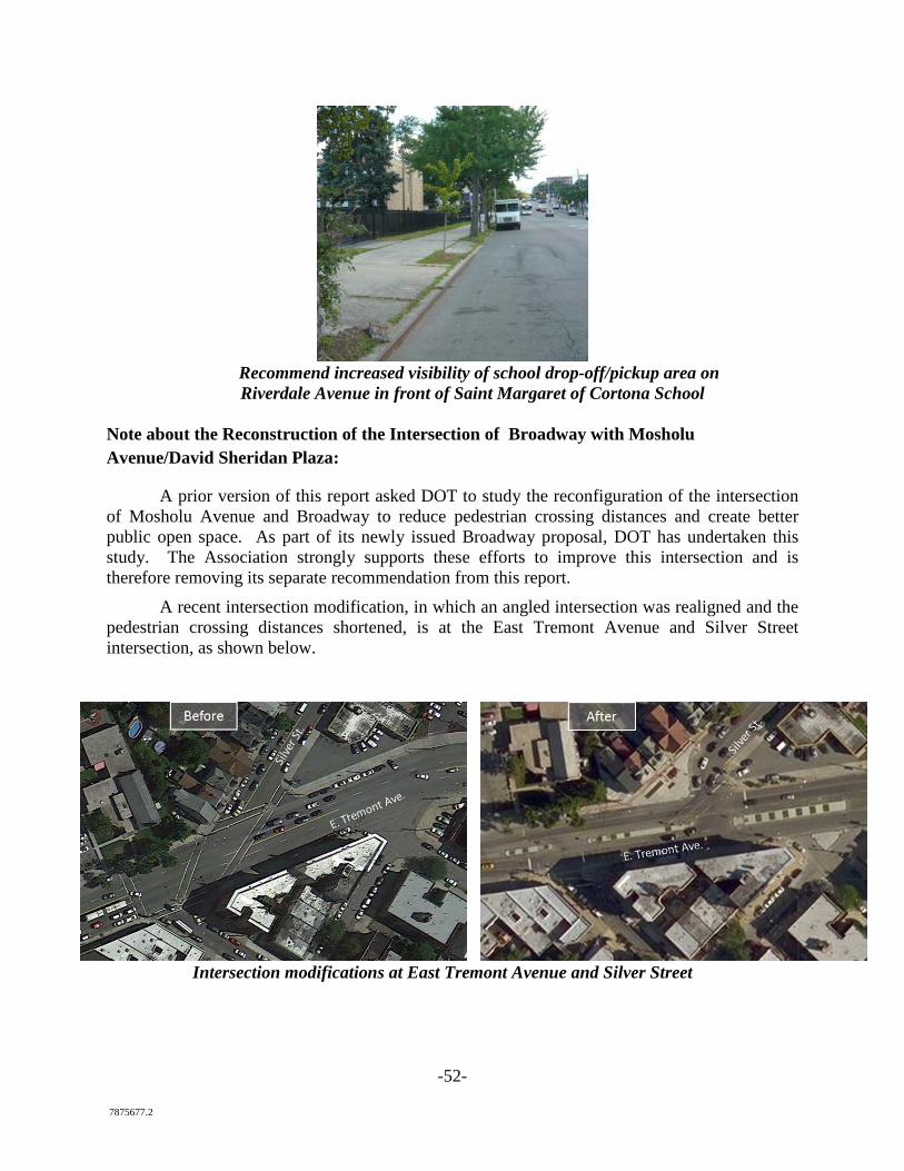
A recent intersection modification, in which an angled intersection was realigned and the pedestrian crossing distances shortened, is at the East Tremont Avenue and Silver Street intersection, as shown below.
Intersection modifications at East Tremont Avenue and Silver Street
7875677.2
Exhibits
For the purposes of saving space and paper, only exhibits A, B, C and D are attached to hard copies of this report. Exhibits E, F, G and H are available at the project website or at
the links below.
Exhibit A: 2015 Existing Conditions Report, Executive Summary14 Exhibit B: Summary of Public Comments and Responses (attached) Exhibit C: Long-term Beautification and traffic Ideas
1. Raised, landscaped median 2. Traffic circle at City Line 3. Bury power lines
Exhibit D: Streetscape Reporter Supporters Exhibit E: VHB Engineering Analysis of Riverdale Avenue. Exhibit F: 2016 NYC DOT Presentation Regarding Vision Zero Program (available on project website or http://www.nyc.gov/html/dot/downloads/pdf/urban-road-diets-june2016.pdf) Exhibit G: 2016 NYC DOT Report Regarding Vision Zero Successes in Other Communities (available on project website or http://www.nyc.gov/html/visionzero/assets/downloads/pdf/vision-zero-year-two-report.pdf) Exhibit H: NYC DOT, Economic Benefits of Sustainable Streets (available on project website http://www.nyc.gov/html/dot/downloads/pdf/dot-economic-benefits-of-sustainable-streets.pdf)
14 Please contact the Association for a full copy of the existing conditions report.
1 7875677.2
Exhibit A: Executive Summary to Existing Conditions Report
I. Introduction
This Existing Conditions Report is the first of two reports that VHB will produce as part of the Riverdale, Bronx, NYC Smart Growth Plan (“Smart Growth Plan”). In early 2015, the North Riverdale Merchant and Business Association secured a $100,000 grant from the New York State Energy Research and Development Authority through its Cleaner Greener Communities program. The Association is cooperating with elected officials, the New York City Department of Transportation and other community stakeholders to produce the Smart Growth Plan, which will address traffic and pedestrian safety, economic development and environmental sustainability in portions of Riverdale’s business districts. This Existing Conditions Report documents conditions, issues and problems that the Smart Growth Plan will attempt to resolve. The entire project will be documented for public review and participation at www.riverdalebronx.nyc during 2015 and 2016. This Existing Conditions Report identifies a number of serious problems in the studied downtown business districts. They include:
• correctable traffic accidents, sometimes involving pedestrian injuries • speeding • deteriorating crosswalks, street painting, parking and bus zones and the need for
better conditions for persons with disabilities • potentially unsafe access on Palisade Avenue and W. 254th Street to the Metro-North
Railroad station • lack of crossings from residential areas to Van Cortlandt Park • deteriorating tree pits and street trees • lack of plantings, signage and visual amenities in key business areas • underutilized or empty storefronts and commercial sites.
These conditions in the business districts have persisted despite the community’s acclaimed nonprofit and educational institutions, high population density, parks and sought-after residential neighborhoods (including North Riverdale, Fieldston and Skyview). The Smart Growth Plan will try to address this disconnect as streetscape projects in other communities (in both the City and its suburbs) have done in the past decade, using the community’s many assets as the basis to support a revitalization of the business districts and creation of a true “downtown” for the community. Home to almost 30,000 people, the Project Area includes portions of three corridors in the Riverdale neighborhood in the Bronx Borough of the City of New York: Riverdale Avenue (from 254th Street north), Mosholu Avenue, and Broadway (from 242nd Street north). This Smart Growth Plan first assesses the existing conditions within the corridors relating to traffic, transportation, as well as existing and planned development. The Project Area’s public realm is also analyzed, evaluating streetscape elements, sidewalks and overall mobility. After the completion of the assessment of existing conditions, corridor needs and opportunities will be developed, and a plan will be developed for public review and input to direct future improvements along the corridors so that they will best fulfill their intended purposes.
-2- 7875677.2
II. History Initial, significant development of the Riverdale neighborhood began with the arrival of the railroad in 1850, prior to which Riverdale was connected to the City by Broadway, then a carriage road. Riverdale gradually became a picturesque suburb of New York City with its large villa estates. Transportation developments also began to take place during this period, incorporating improved roads, steamboats, ferries, and railroads with a new station built in 1889 with access to Grand Central Terminal. This was crucial in Riverdale’s transition from a country destination to a year-round community. Riverdale continued to develop during the 20th century. In 1909, the IRT Broadway – Seventh Avenue Line was extended to Van Cortlandt Park – 242nd Street. Upscale apartment buildings began to be built along with the establishment of numerous churches, synagogues, private schools, and cultural and higher education institutions. The Russian Mission to the United Nations was also constructed in 1974. In recent years Riverdale has continued to maintain its character as a middle-class and affluent enclave in the City of New York, although, other than small-scale development, there has been limited investment in the upkeep of infrastructure and property along the subject corridors in the Project Area.
III. Summary of Existing Conditions
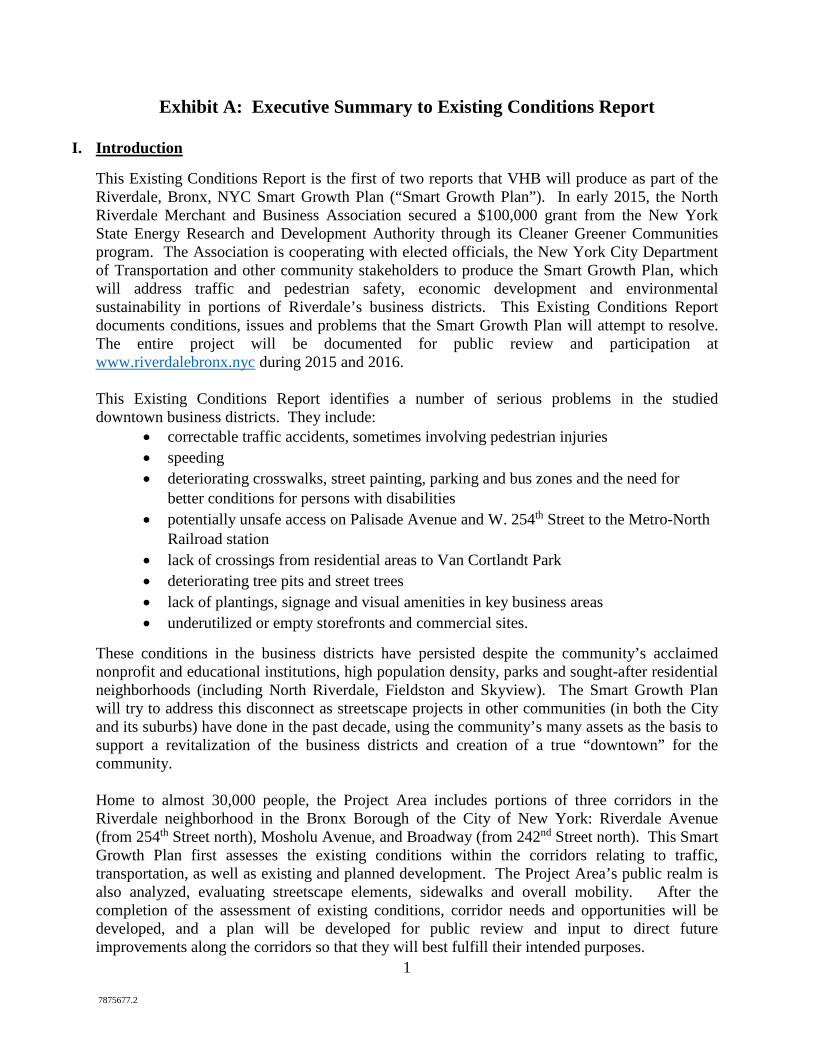
This assessment of existing conditions on Riverdale Avenue, Mosholu Avenue and Broadway for each of the key elements noted above is summarized below.
Community Character and Zoning The existing land use patterns within the Project Area are mostly long-established, low-rise single-family and mid-rise multifamily residences. Neighborhood commercial land uses are present along the three corridors, which include some mixed-use buildings. Most are independently owned and operated, although there are some national chains, such as the Sunoco gas station, Capital One Bank and Burger King. There is also a prominent retail development on Riverdale Avenue known as the Skyview Shopping Center. Numerous educational and religious institutions are situated throughout the Project Area. An inspection of properties along the corridors revealed that some were in need of significant maintenance and that there were a number of commercial vacancies. It was also noted that, in certain areas, the strength of commercial development was diminished by its somewhat fragmented development pattern, with the connection between some commercial properties being weakened by the presence of high stone walls (along Mosholu Avenue) or residential development. There is potential for reinvestment and development within the Project Area, especially along the Riverdale Avenue and Broadway corridors, where eight privately owned sites were identified for potential redevelopment. These sites were considered underutilized based on their physical characteristics. Most of these underutilized sites are under-built based on the Floor Area Ratio (FAR) allowed in its current zoning district. Redevelopment of these sites would complement
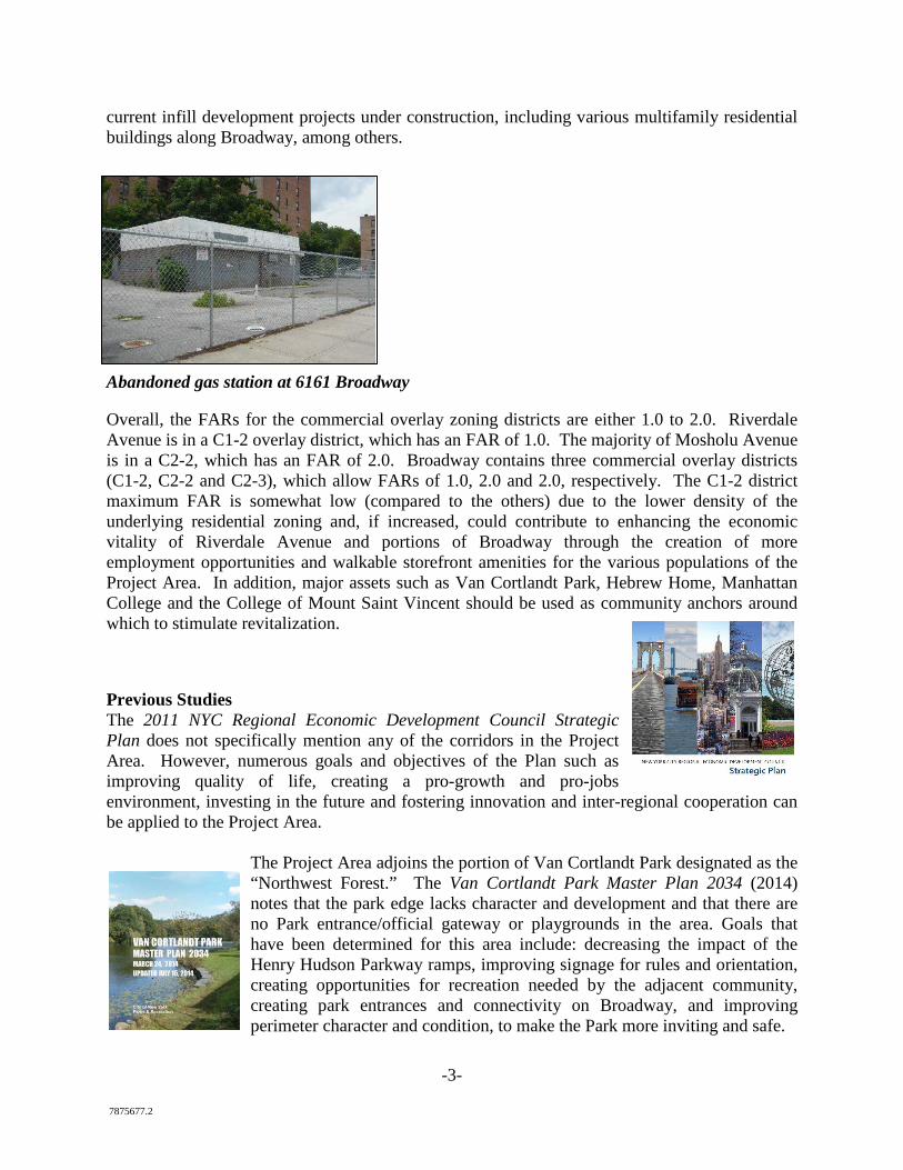
-3- 7875677.2
current infill development projects under construction, including various multifamily residential buildings along Broadway, among others.
Abandoned gas station at 6161 Broadway Overall, the FARs for the commercial overlay zoning districts are either 1.0 to 2.0. Riverdale Avenue is in a C1-2 overlay district, which has an FAR of 1.0. The majority of Mosholu Avenue is in a C2-2, which has an FAR of 2.0. Broadway contains three commercial overlay districts (C1-2, C2-2 and C2-3), which allow FARs of 1.0, 2.0 and 2.0, respectively. The C1-2 district maximum FAR is somewhat low (compared to the others) due to the lower density of the underlying residential zoning and, if increased, could contribute to enhancing the economic vitality of Riverdale Avenue and portions of Broadway through the creation of more employment opportunities and walkable storefront amenities for the various populations of the Project Area. In addition, major assets such as Van Cortlandt Park, Hebrew Home, Manhattan College and the College of Mount Saint Vincent should be used as community anchors around which to stimulate revitalization.
Previous Studies The 2011 NYC Regional Economic Development Council Strategic Plan does not specifically mention any of the corridors in the Project Area. However, numerous goals and objectives of the Plan such as improving quality of life, creating a pro-growth and pro-jobs environment, investing in the future and fostering innovation and inter-regional cooperation can be applied to the Project Area.
The Project Area adjoins the portion of Van Cortlandt Park designated as the “Northwest Forest.” The Van Cortlandt Park Master Plan 2034 (2014) notes that the park edge lacks character and development and that there are no Park entrance/official gateway or playgrounds in the area. Goals that have been determined for this area include: decreasing the impact of the Henry Hudson Parkway ramps, improving signage for rules and orientation, creating opportunities for recreation needed by the adjacent community, creating park entrances and connectivity on Broadway, and improving perimeter character and condition, to make the Park more inviting and safe.
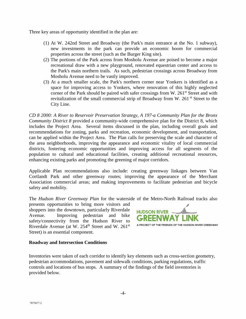
-4- 7875677.2
Three key areas of opportunity identified in the plan are:
(1) At W. 242nd Street and Broadway (the Park's main entrance at the No. 1 subway), new investments in the park can provide an economic boom for commercial properties across the street (such as the Burger King site).
(2) The portions of the Park across from Mosholu Avenue are poised to become a major recreational draw with a new playground, renovated equestrian center and access to the Park's main northern trails. As such, pedestrian crossings across Broadway from Mosholu Avenue need to be vastly improved.
(3) At a much smaller scale, the Park's northern corner near Yonkers is identified as a space for improving access to Yonkers, where renovation of this highly neglected corner of the Park should be paired with safer crossings from W. 261st Street and with revitalization of the small commercial strip of Broadway from W. 261 st Street to the City Line.
CD 8 2000: A River to Reservoir Preservation Strategy, A 197-a Community Plan for the Bronx Community District 8 provided a community-wide comprehensive plan for the District 8, which includes the Project Area. Several items discussed in the plan, including overall goals and recommendations for zoning, parks and recreation, economic development, and transportation, can be applied within the Project Area. The Plan calls for preserving the scale and character of the area neighborhoods, improving the appearance and economic vitality of local commercial districts, fostering economic opportunities and improving access for all segments of the population to cultural and educational facilities, creating additional recreational resources, enhancing existing parks and promoting the greening of major corridors. Applicable Plan recommendations also include: creating greenway linkages between Van Cortlandt Park and other greenway routes; improving the appearance of the Merchant Association commercial areas; and making improvements to facilitate pedestrian and bicycle safety and mobility. The Hudson River Greenway Plan for the waterside of the Metro-North Railroad tracks also presents opportunities to bring more visitors and shoppers into the downtown, particularly Riverdale Avenue. Improving pedestrian and bike safety/connectivity from the Hudson River to Riverdale Avenue (at W. 254th Street and W. 261st Street) is an essential component.
Roadway and Intersection Conditions Inventories were taken of each corridor to identify key elements such as cross-section geometry, pedestrian accommodations, pavement and sidewalk conditions, parking regulations, traffic controls and locations of bus stops. A summary of the findings of the field inventories is provided below.
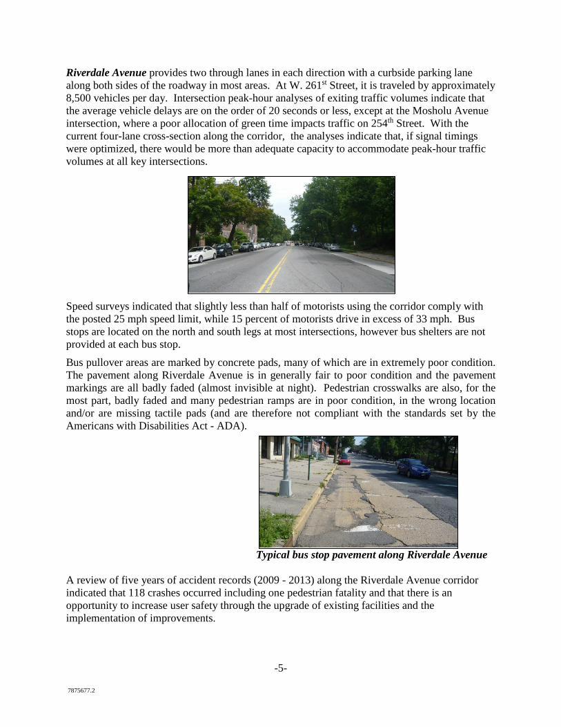
-5- 7875677.2
Riverdale Avenue provides two through lanes in each direction with a curbside parking lane along both sides of the roadway in most areas. At W. 261st Street, it is traveled by approximately 8,500 vehicles per day. Intersection peak-hour analyses of exiting traffic volumes indicate that the average vehicle delays are on the order of 20 seconds or less, except at the Mosholu Avenue intersection, where a poor allocation of green time impacts traffic on 254th Street. With the current four-lane cross-section along the corridor, the analyses indicate that, if signal timings were optimized, there would be more than adequate capacity to accommodate peak-hour traffic volumes at all key intersections.
Speed surveys indicated that slightly less than half of motorists using the corridor comply with the posted 25 mph speed limit, while 15 percent of motorists drive in excess of 33 mph. Bus stops are located on the north and south legs at most intersections, however bus shelters are not provided at each bus stop. Bus pullover areas are marked by concrete pads, many of which are in extremely poor condition. The pavement along Riverdale Avenue is in generally fair to poor condition and the pavement markings are all badly faded (almost invisible at night). Pedestrian crosswalks are also, for the most part, badly faded and many pedestrian ramps are in poor condition, in the wrong location and/or are missing tactile pads (and are therefore not compliant with the standards set by the Americans with Disabilities Act - ADA).
Typical bus stop pavement along Riverdale Avenue A review of five years of accident records (2009 - 2013) along the Riverdale Avenue corridor indicated that 118 crashes occurred including one pedestrian fatality and that there is an opportunity to increase user safety through the upgrade of existing facilities and the implementation of improvements.
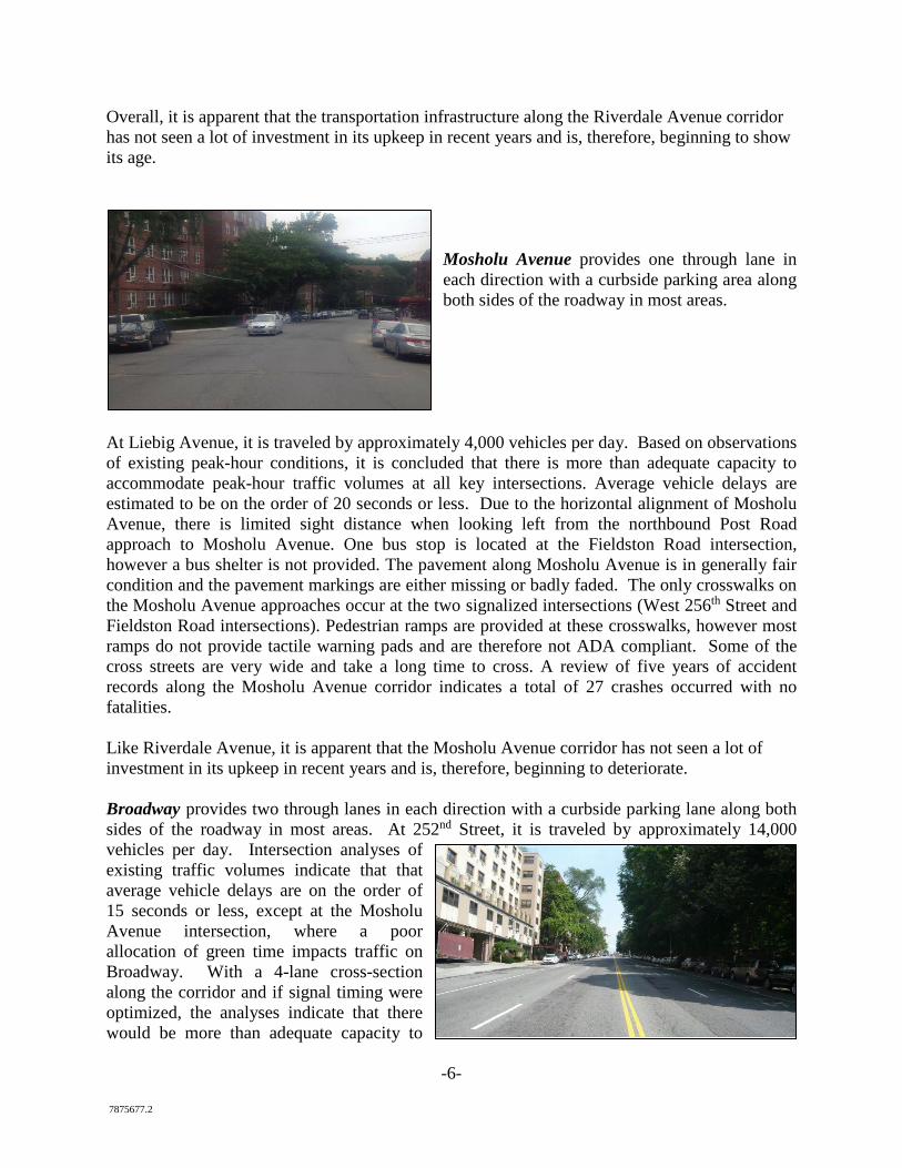
-6- 7875677.2
Overall, it is apparent that the transportation infrastructure along the Riverdale Avenue corridor has not seen a lot of investment in its upkeep in recent years and is, therefore, beginning to show its age.
Mosholu Avenue provides one through lane in each direction with a curbside parking area along both sides of the roadway in most areas.
At Liebig Avenue, it is traveled by approximately 4,000 vehicles per day. Based on observations of existing peak-hour conditions, it is concluded that there is more than adequate capacity to accommodate peak-hour traffic volumes at all key intersections. Average vehicle delays are estimated to be on the order of 20 seconds or less. Due to the horizontal alignment of Mosholu Avenue, there is limited sight distance when looking left from the northbound Post Road approach to Mosholu Avenue. One bus stop is located at the Fieldston Road intersection, however a bus shelter is not provided. The pavement along Mosholu Avenue is in generally fair condition and the pavement markings are either missing or badly faded. The only crosswalks on the Mosholu Avenue approaches occur at the two signalized intersections (West 256th Street and Fieldston Road intersections). Pedestrian ramps are provided at these crosswalks, however most ramps do not provide tactile warning pads and are therefore not ADA compliant. Some of the cross streets are very wide and take a long time to cross. A review of five years of accident records along the Mosholu Avenue corridor indicates a total of 27 crashes occurred with no fatalities. Like Riverdale Avenue, it is apparent that the Mosholu Avenue corridor has not seen a lot of investment in its upkeep in recent years and is, therefore, beginning to deteriorate. Broadway provides two through lanes in each direction with a curbside parking lane along both sides of the roadway in most areas. At 252nd Street, it is traveled by approximately 14,000 vehicles per day. Intersection analyses of existing traffic volumes indicate that that average vehicle delays are on the order of 15 seconds or less, except at the Mosholu Avenue intersection, where a poor allocation of green time impacts traffic on Broadway. With a 4-lane cross-section along the corridor and if signal timing were optimized, the analyses indicate that there would be more than adequate capacity to
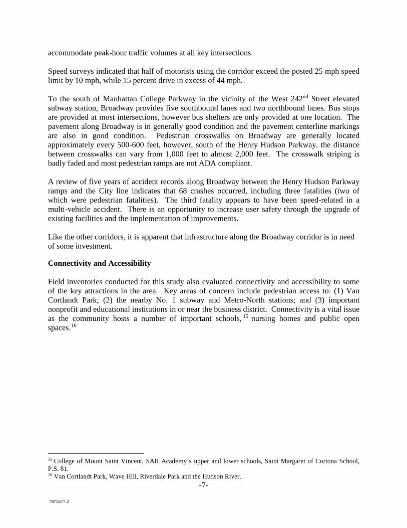
-7- 7875677.2
accommodate peak-hour traffic volumes at all key intersections. Speed surveys indicated that half of motorists using the corridor exceed the posted 25 mph speed limit by 10 mph, while 15 percent drive in excess of 44 mph. To the south of Manhattan College Parkway in the vicinity of the West 242nd Street elevated subway station, Broadway provides five southbound lanes and two northbound lanes. Bus stops are provided at most intersections, however bus shelters are only provided at one location. The pavement along Broadway is in generally good condition and the pavement centerline markings are also in good condition. Pedestrian crosswalks on Broadway are generally located approximately every 500-600 feet, however, south of the Henry Hudson Parkway, the distance between crosswalks can vary from 1,000 feet to almost 2,000 feet. The crosswalk striping is badly faded and most pedestrian ramps are not ADA compliant. A review of five years of accident records along Broadway between the Henry Hudson Parkway ramps and the City line indicates that 68 crashes occurred, including three fatalities (two of which were pedestrian fatalities). The third fatality appears to have been speed-related in a multi-vehicle accident. There is an opportunity to increase user safety through the upgrade of existing facilities and the implementation of improvements. Like the other corridors, it is apparent that infrastructure along the Broadway corridor is in need of some investment.
Connectivity and Accessibility Field inventories conducted for this study also evaluated connectivity and accessibility to some of the key attractions in the area. Key areas of concern include pedestrian access to: (1) Van Cortlandt Park; (2) the nearby No. 1 subway and Metro-North stations; and (3) important nonprofit and educational institutions in or near the business district. Connectivity is a vital issue as the community hosts a number of important schools, 15 nursing homes and public open spaces.16
15 College of Mount Saint Vincent, SAR Academy’s upper and lower schools, Saint Margaret of Cortona School, P.S. 81. 16 Van Cortlandt Park, Wave Hill, Riverdale Park and the Hudson River.
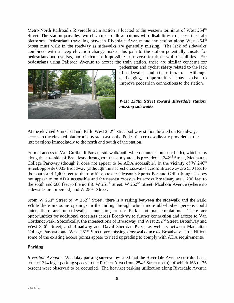
-8- 7875677.2
Metro-North Railroad’s Riverdale train station is located at the western terminus of West 254th Street. The station provides two elevators to allow patrons with disabilities to access the train platforms. Pedestrians travelling between Riverdale Avenue and the station along West 254th
Street must walk in the roadway as sidewalks are generally missing. The lack of sidewalks combined with a steep elevation change makes this path to the station potentially unsafe for pedestrians and cyclists, and difficult or impossible to traverse for those with disabilities. For pedestrians using Palisade Avenue to access the train station, there are similar concerns for
pedestrian and cyclist safety related to the lack of sidewalks and steep terrain. Although challenging, opportunities may exist to improve pedestrian connections to the station.
West 254th Street toward Riverdale station, missing sidewalks
At the elevated Van Cortlandt Park–West 242nd Street subway station located on Broadway, access to the elevated platform is by staircase only. Pedestrian crosswalks are provided at the intersections immediately to the north and south of the station. Formal access to Van Cortlandt Park (a sidewalk/path which connects into the Park), which runs along the east side of Broadway throughout the study area, is provided at 242nd Street, Manhattan College Parkway (though it does not appear to be ADA accessible), in the vicinity of W 246th Street/opposite 6035 Broadway (although the nearest crosswalks across Broadway are 550 feet to the south and 1,400 feet to the north), opposite Gleason’s Sports Bar and Grill (though it does not appear to be ADA accessible and the nearest crosswalks across Broadway are 1,200 feet to the south and 600 feet to the north), W 251st Street, W 252nd Street, Mosholu Avenue (where no sidewalks are provided) and W 259th Street. From W 251st Street to W 252nd Street, there is a railing between the sidewalk and the Park. While there are some openings in the railing through which more able-bodied persons could enter, there are no sidewalks connecting to the Park’s internal circulation. There are opportunities for additional crossings across Broadway to further connection and access to Van Cortlandt Park. Specifically, the intersections of Broadway and West 252nd Street, Broadway and West 256th Street, and Broadway and David Sheridan Plaza, as well as between Manhattan College Parkway and West 251st Street, are missing crosswalks across Broadway. In addition, some of the existing access points appear to need upgrading to comply with ADA requirements.
Parking Riverdale Avenue – Weekday parking surveys revealed that the Riverdale Avenue corridor has a total of 214 legal parking spaces in the Project Area (from 254th Street north), of which 163 or 76 percent were observed to be occupied. The heaviest parking utilization along Riverdale Avenue
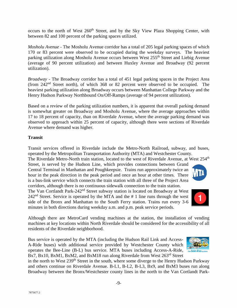
-9- 7875677.2
occurs to the north of West 260th Street, and by the Sky View Plaza Shopping Center, with between 82 and 100 percent of the parking spaces utilized. Mosholu Avenue - The Mosholu Avenue corridor has a total of 205 legal parking spaces of which 170 or 83 percent were observed to be occupied during the weekday surveys. The heaviest parking utilization along Mosholu Avenue occurs between West 255th Street and Liebig Avenue (average of 90 percent utilization) and between Huxley Avenue and Broadway (92 percent utilization). Broadway - The Broadway corridor has a total of 451 legal parking spaces in the Project Area (from 242nd Street north), of which 368 or 82 percent were observed to be occupied. The heaviest parking utilization along Broadway occurs between Manhattan College Parkway and the Henry Hudson Parkway Northbound On/Off-Ramps (average of 94 percent utilization). Based on a review of the parking utilization numbers, it is apparent that overall parking demand is somewhat greater on Broadway and Mosholu Avenue, where the average approaches within 17 to 18 percent of capacity, than on Riverdale Avenue, where the average parking demand was observed to approach within 25 percent of capacity, although there were sections of Riverdale Avenue where demand was higher.
Transit Transit services offered in Riverdale include the Metro-North Railroad, subway, and buses, operated by the Metropolitan Transportation Authority (MTA) and Westchester County. The Riverdale Metro-North train station, located to the west of Riverdale Avenue, at West 254th Street, is served by the Hudson Line, which provides connections between Grand Central Terminal in Manhattan and Poughkeepsie. Trains run approximately twice an hour in the peak direction in the peak period and once an hour at other times. There is a bus-link service which connects the train station with all three of the Project Area corridors, although there is no continuous sidewalk connection to the train station. The Van Cortlandt Park-242nd Street subway station is located on Broadway at West 242nd Street. Service is operated by the MTA and the # 1 line runs through the west side of the Bronx and Manhattan to the South Ferry station. Trains run every 3-6 minutes in both directions during weekday a.m. and p.m. peak service periods. Although there are MetroCard vending machines at the station, the installation of vending machines at key locations within North Riverdale should be considered for the accessibility of all residents of the Riverdale neighborhood. Bus service is operated by the MTA (including the Hudson Rail Link and Access-A-Ride buses) with additional service provided by Westchester County which operates the Bee-Line (B-L) bus service. MTA buses including Access-A-Ride, Bx7, Bx10, BxM1, BxM2, and BxM18 run along Riverdale from West 263rd Street in the north to West 239th Street in the south, where some diverge to the Henry Hudson Parkway and others continue on Riverdale Avenue. B-L1, B-L2, B-L3, Bx9, and BxM3 buses run along Broadway between the Bronx/Westchester county lines in the north to the Van Cortlandt Park-
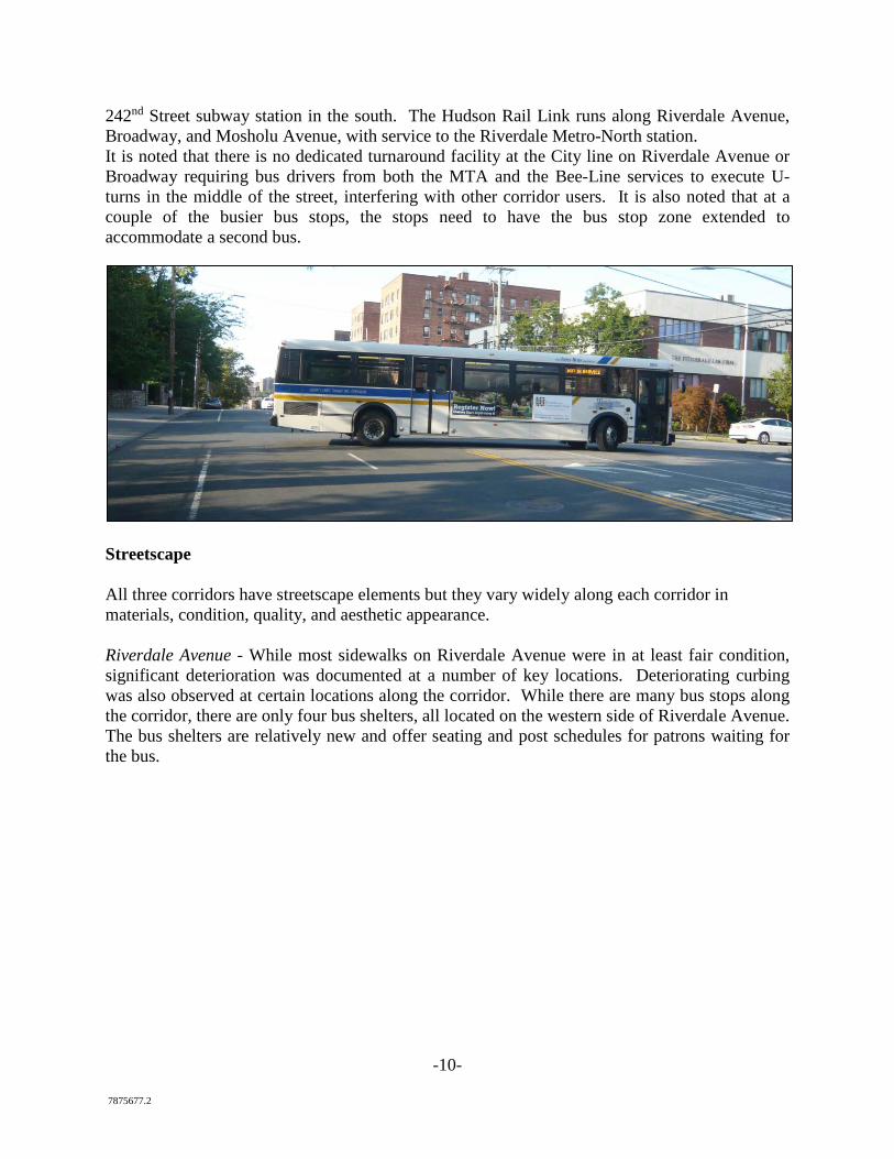
-10- 7875677.2
242nd Street subway station in the south. The Hudson Rail Link runs along Riverdale Avenue, Broadway, and Mosholu Avenue, with service to the Riverdale Metro-North station. It is noted that there is no dedicated turnaround facility at the City line on Riverdale Avenue or Broadway requiring bus drivers from both the MTA and the Bee-Line services to execute U-turns in the middle of the street, interfering with other corridor users. It is also noted that at a couple of the busier bus stops, the stops need to have the bus stop zone extended to accommodate a second bus.
Streetscape All three corridors have streetscape elements but they vary widely along each corridor in materials, condition, quality, and aesthetic appearance. Riverdale Avenue - While most sidewalks on Riverdale Avenue were in at least fair condition, significant deterioration was documented at a number of key locations. Deteriorating curbing was also observed at certain locations along the corridor. While there are many bus stops along the corridor, there are only four bus shelters, all located on the western side of Riverdale Avenue. The bus shelters are relatively new and offer seating and post schedules for patrons waiting for the bus.
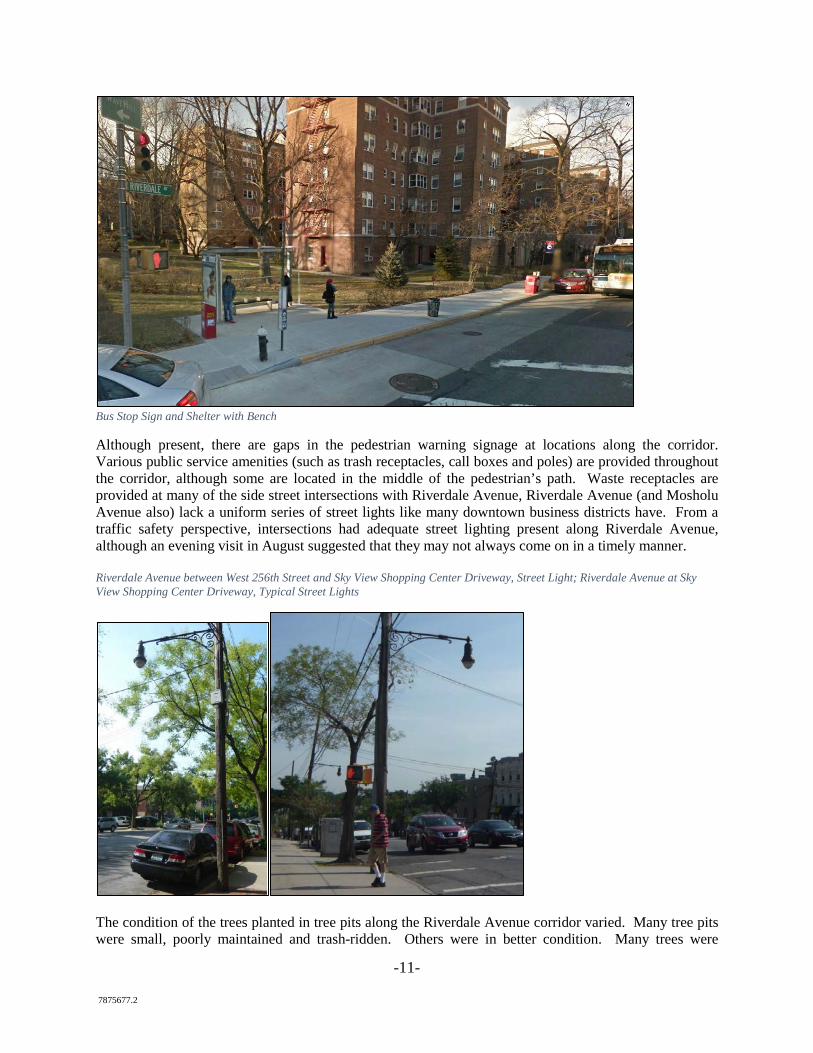
-11- 7875677.2
Bus Stop Sign and Shelter with Bench
Although present, there are gaps in the pedestrian warning signage at locations along the corridor. Various public service amenities (such as trash receptacles, call boxes and poles) are provided throughout the corridor, although some are located in the middle of the pedestrian’s path. Waste receptacles are provided at many of the side street intersections with Riverdale Avenue, Riverdale Avenue (and Mosholu Avenue also) lack a uniform series of street lights like many downtown business districts have. From a traffic safety perspective, intersections had adequate street lighting present along Riverdale Avenue, although an evening visit in August suggested that they may not always come on in a timely manner. Riverdale Avenue between West 256th Street and Sky View Shopping Center Driveway, Street Light; Riverdale Avenue at Sky View Shopping Center Driveway, Typical Street Lights
The condition of the trees planted in tree pits along the Riverdale Avenue corridor varied. Many tree pits were small, poorly maintained and trash-ridden. Others were in better condition. Many trees were
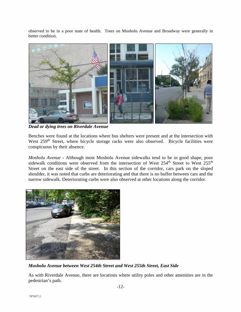
-12- 7875677.2
observed to be in a poor state of health. Trees on Mosholu Avenue and Broadway were generally in better condition.
Dead or dying trees on Riverdale Avenue
Benches were found at the locations where bus shelters were present and at the intersection with West 259th Street, where bicycle storage racks were also observed. Bicycle facilities were conspicuous by their absence. Mosholu Avenue - Although most Mosholu Avenue sidewalks tend to be in good shape, poor sidewalk conditions were observed from the intersection of West 254th Street to West 255th Street on the east side of the street. In this section of the corridor, cars park on the sloped shoulder, it was noted that curbs are deteriorating and that there is no buffer between cars and the narrow sidewalk. Deteriorating curbs were also observed at other locations along the corridor.
Mosholu Avenue between West 254th Street and West 255th Street, East Side
As with Riverdale Avenue, there are locations where utility poles and other amenities are in the pedestrian’s path.
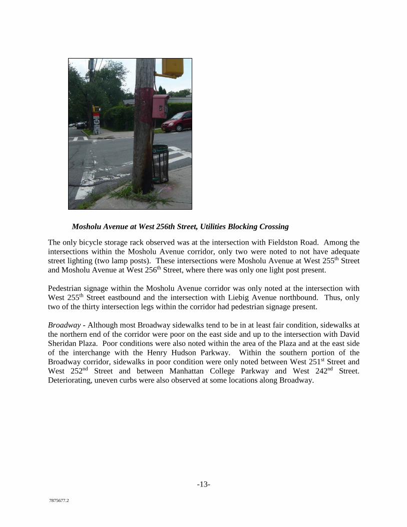
-13- 7875677.2
Mosholu Avenue at West 256th Street, Utilities Blocking Crossing
The only bicycle storage rack observed was at the intersection with Fieldston Road. Among the intersections within the Mosholu Avenue corridor, only two were noted to not have adequate street lighting (two lamp posts). These intersections were Mosholu Avenue at West 255th Street and Mosholu Avenue at West 256th Street, where there was only one light post present. Pedestrian signage within the Mosholu Avenue corridor was only noted at the intersection with West 255th Street eastbound and the intersection with Liebig Avenue northbound. Thus, only two of the thirty intersection legs within the corridor had pedestrian signage present. Broadway - Although most Broadway sidewalks tend to be in at least fair condition, sidewalks at the northern end of the corridor were poor on the east side and up to the intersection with David Sheridan Plaza. Poor conditions were also noted within the area of the Plaza and at the east side of the interchange with the Henry Hudson Parkway. Within the southern portion of the Broadway corridor, sidewalks in poor condition were only noted between West 251st Street and West 252nd Street and between Manhattan College Parkway and West 242nd Street. Deteriorating, uneven curbs were also observed at some locations along Broadway.
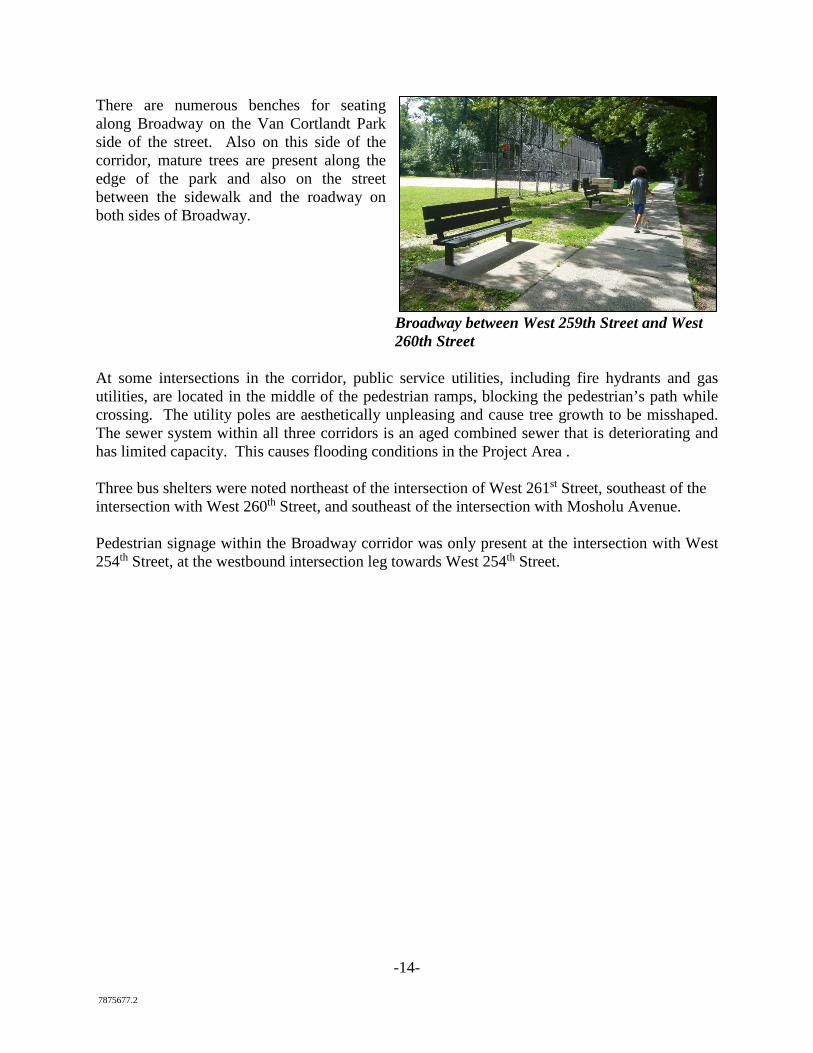
-14- 7875677.2
There are numerous benches for seating along Broadway on the Van Cortlandt Park side of the street. Also on this side of the corridor, mature trees are present along the edge of the park and also on the street between the sidewalk and the roadway on both sides of Broadway.
Broadway between West 259th Street and West 260th Street
At some intersections in the corridor, public service utilities, including fire hydrants and gas utilities, are located in the middle of the pedestrian ramps, blocking the pedestrian’s path while crossing. The utility poles are aesthetically unpleasing and cause tree growth to be misshaped. The sewer system within all three corridors is an aged combined sewer that is deteriorating and has limited capacity. This causes flooding conditions in the Project Area . Three bus shelters were noted northeast of the intersection of West 261st Street, southeast of the intersection with West 260th Street, and southeast of the intersection with Mosholu Avenue. Pedestrian signage within the Broadway corridor was only present at the intersection with West 254th Street, at the westbound intersection leg towards West 254th Street.
-15- 7875677.2
Exhibit B: Summary of Public Comments and Responses
The Association continues to receive feedback through formal meetings with advisory committee members, through e-mails and letters and anedotally from public comments or letters to elected officials that were informally provided to the Association. A summary follows. The comments are not presented in order of significance.
1. A road diet on Riverdale Avenue will slow traffic or create congestion.
NYC DOT data shows that road diets, where a lane of traffic in each direction is replaced with a dedicated left-turn lane, improves traffic flow. VHB has confirmed that the same would be true on Riverdale Avenue. Regardless, the Association is senstive to the many comments submitted on this issue and has therefore revised the report to change this from a “recommendation” to DOT to a “request for DOT to study” this or other improvements. The Association is enthusiastic to learn from DOT whether this or perhaps other changes to the roadway can improve its function, safety and appearance. But the study must be done ASAP given the high pedestrian injury rate, number of school children, deteriorating appearance and number of vacant storefronts.
2. A median will block emergency vehicles.
DOT should study this issue. But as the median would be painted at first, it would not block emergency vehicles. In fact, by creating a lane for them to use to bypass traffic or double parked vehicles, it would likely improve conditions.
3. The road diet will make double-parking worse.
DOT should study this issue. But the proposed idea would improve (NOT WORSEN) the ability of Riverdale and Mosholu to handle double parking by creating wider traffic lanes and a parking buffer, thus removing double-parked vehicles from traffic lanes as now occurs. THE CURRENT CONDITIONS ARE NOT ACCEPTABLE TO THE ASSOCIATION.
4. New street trees should not be planted as they increase leaf litter.
The Association agrees that NYC Parks must do a better job maintaining street trees and replacing dead trees. But street trees are vitally important to improving the environment and appearance of public streets.
5. A new traffic connection should not be made on Netherland Avenue between West 255th and 256th Street.
The report does not recommend the creation of a traffic connection. It recommends the
creation of a sidewalk connection so pedestrians can reach Metro North, schools and businesses more easily.
-16- 7875677.2
6. The bus stop at Riverdale Avenue and West 254th Street should not be moved
from the north to the south side of the street.
The Association agrees and has removed that idea from the report.
7. The report should not include Broadway because DOT is already studying it.
Midway through this planning process, DOT participated in a community meeting regarding the re-design of Broadway—a vitally important issue. The Association agrees and has taken Broadway out of the report.
8. The report should not make recommendations about zoning.
Zoning is beyond the scope of this report and is therefore not included.
9. NYSERDA should not be funding community planning processes like this.
Smart Growth is a planning concept that (among other things) encourages public investment in existing communities to encourage walking, local shopping and thereby improve public health and the environment. NYSERDA’s Cleaner, Greener Communities Program is focused specifically on these goals, which are incorporated into this report.
10. The draft plan will bring about positive changes to vehicle flow.
Comment noted.
11. Pedestrian crosswalks (i.e., West 259th Street) do not provide enough time for crossing.
The draft report will incorporate a request to DOT to study this issue.
12. Double and triple parking in front of P.S. 81 creates safety issues for children’s safety.
The Association shares this concern and has incorporated it into this report. The creation
of larger parking lane and buffer would help remove double-parked vehiles from the flow of traffic and therefore improve student safety. Triple parking cannot be accomodated.
13. Individual home and business owners will probably not take care of tree pits.
The Association shares this concern and is therefore committed to maintaining improved tree pits and other sidewalk improvements.
14. Will there be vagrancy on new benches or seating areas?
-17- 7875677.2
The Association shares this concern. The DOT’s Citibenches are designed to prevent reclining and sleeping. Any table seating at Mosholu and Broadway (or other outdoor seating areas) should be under the control of an adjacent restaurant.
15. DOT implemented similar changes on Allerton Avenue in the East Bronx and it had a negative impact on traffic.
DOT has released a report on the Allerton Avenue project, which is similar to the goals
for Riverdale Avenue. The report shows a 28% reduction in crashes with pedestrian injuries. As with all signficant improvements, DOT consults with the community board and elected officials before proceeding. In the case of Allerton Avenue, a planning process proceeded with DOT making changes to a proposal after receiving community feedback. The Association supports a similar public planning process for Riverdale Avenue.
16. Changes to traffic lanes are not necessary to improve safety on Riverdale Avenue.
DOT credits its complete streets (2002-2014) and Vision Zero (2014 to present) programs with reducing pedestrian injuries by 30% in the five boroughs. https://www.smartgrowthamerica.org/app/legacy/documents/cs/impl/ny-nyc-makingsaferstreets.pdf.
VHB did careful analysis of the number and types of crashes that occurred on Riverdale Avenue and Mosholu Avenue from 2009 to 2013. It also considered pedestrian injuries. And it compared this data to averages prepared by the NYS Department of Transportation. Its findings are documented in the Existing Conditions Report.
VHB found 118 crashes on Riverdale Avenue and 27 on Mosholu Avenue. About 50% of crashes in Riverdale and 41% on Mosholu Avenue involved injuries to pedestrians compared to just 25% statewide. This data underscores the need to apply the Vision Zero program to both streets.
17. The report should address stormwater problems, sink holes and the need for better stormwater management.
The Association agrees that the City must address these issues, particularly on Mosholu
Avenue. But they are beyond the scope of this report. The Association has therefore separately sent a letter to the New York City Department of Environmental Protection, explaining the comments received and calling for improvements.
18. The report should not call for a traffic circle on Riverdale Avenue north of the cityline because only the City of Yonkers can make that change.
Yonkers and the New York City DOT do work together on traffic improvements. The
Association supports DOT’s study of the traffic circle but expects it to be a long-term goal.
19. Changes to Riverdale Avenue will slow traffic, encouraging drivers to use side streets.
-18- 7875677.2
VHB has concluded that changes to Riverdale Avenue would not reduce the time
required to traverse the avenue. Drivers would therefore not have an incentive to use side streets. Nevertheless, the Association asks DOT to study this issue before making any changes to local streets. The Association supports DOT’s ongoing efforts to slow traffic on side streets with signage, marked pedestrian crossings and speed bumps.
20. The report should not call for removal of parking spaces. There is not enough street parking.
Riverdale Avenue and Mosholu Avenue have about 419 on-street parking spaces. A prior
draft of the report suggested that the removal of about 24 spaces could improve pedestrian safety by allowing drivers to see crossings as they approach an intersection. The report no longer includes recommendations for targeted removal of parking spaces in order to improve pedestrian safety. But it will continue to ask DOT to study safety improvements to intersections.
21. The community board is already endorsing a sidewalk along the entire length of West 254th Street.
The Association supports the community board’s request.
22. DOT should create a pedestrian crossing on Mosholu Avenue and West 255th Street to faciliate children’s access to Riverdale Neighborhood House, P.S. 81 and Vinmont Park.
The Association has added this request to the report.
23. The City should bury the overhead power lines.
The Association shares this goal in order to reduce the risk of outages during storms and improve the appearance of both avenues. Con Edison controls the power lines and has informally estimated the cost to be many millions of dollars, which it would require be paid by the City. Buried power lines might also require property owners to pay for new connections. The Association will continue to endorse this goal but it will be long-term.
24. The report should not call for a change to the location of Sheridan Plaza.
VHB found the intersection of Broadway and Mosholu Avenue to be problematic in many respects. Pedestrians must cross Mosholu Avenue twice because of the plaza’s location. The open space does not serve well as a usable public open space because it is separated by traffic. And pedestrian crossing distances across Broadway are too long. With the City’s fortcoming creation of a children’s playground in Van Cortland Park at this location, the Association supports DOT’s studying ways to shorten crossing distances and improve safety. It is also expected that the improved intersection will improve business by getting more park users (e.g., the stable and playground) to walk to Mosholu Avenue for shopping and dining.
25. The Association did not do enough public outreach in this planning process.
-19- 7875677.2
The Association is committed to speaking to every resident, business and institution that
makes that request. To date, the Association has held about 25 meetings, created a website for comments and published an early article in the Riverdale Press about planning process. Please note that DOT will not make changes to traffic flow without its own planning process and consultation with the community board and elected officials.
26. The report should not include bike lanes.
The report does not ask DOT to study bike lanes on Riverdale Avenue and Mosholu Avenue. The parking buffer, however, would provide some protection for bikes.
27. There should be a pestrian crossing in front of SAR Academy on West 259th Street.
This report asks DOT to study the creation of a crossing in this location, which would
improve safety and allow easier access to businesses in Skyview Shopping Center. Note that DOT generally does not install pedestrian crossings except at “controlled” intersections (stop sign or light), which may require a change this street in order to achieve the goal of a pedestrian crossing.
28. The Skyview Shopping Center is a visual and traffic problem.
The Association is concerned about the function of the parking lot and entrance/exits to Skyview Shopping Center (among other commercial sites in Riverdale). But recommendations about private property are beyond the scope of this particular report and the Association will address these concerns at a later time.
29. The report should focus only on beautification.
NYSERDA awarded this grant for beauification, parking safety, traffic safety, pedestrian safety and environmental improvements. The report therefore addresses all these areas of concern.
30. I agree with all the recommendations in this study. Street improvements in this area are overdue. Encouraging people to walk from home to shopping adds value to the neighborhood. Making the streets safer and attractive is worthwhile to all of us.
Comment noted. The Assocation agrees. 31. Cobblestones may be better for storm water capture.
The Association has added a cobblestone median to the report as an example. 32. Explore the City’s innovative street seats program. Riverdale needs more outdoor
seating and dining options.
-20- 7875677.2
Comment noted. See http://www.nyc.gov/html/dot/html/pedestrians/streetseats.shtml
33. Encourage outdoor art exhibits.
The Association agrees and includes this in the Report. 34. Create bike lanes on Riverdale Avenue and Broadway.
The dispute between residents favoring accommodation of bikes and those opposing
accommodation of bikes divides many New York City communities. New York City law, however, allows bikes to use any traffic lines in City streets. Bikers are therefore free to use Riverdale and Mosholu Avenues and conditions on those streets should ensure safety for pedestrians, cars, parking and biking alike. Orderly traffic flow at 25 mile per hour supports all these goals.
The report does not, however, include a recommendation for bike lanes on Riverdale
Avenue and Mosholu Avenue. The Association supports DOT’s current proposal to create a dedicated bike lane on Broadway. The Association is open to the creation of bike sharing stations in the community, particularly on Broadway near the subway.
35. Add stormwater capturing green space up and down the corridors.
The Association agrees. As a first step, the report urges NYC Parks to create new and wider tree pits in appropriate locations, which the Association will work to help clean and landscape. As a second step, the report asks NYC DEP to study the creation of “enhanced” tree pits in Riverdale. As a third step, a center landscape median could serve this function but it is some years away from implementation.
36. Improve transit by putting the Broadway IRT underground or extending it to Getty Square in Yonkers.
Comment noted. These recommendations are beyond the scope of this report. But the Association agrees that improving public transportation is critical to improving business, property values and quality of life.
37. A resident of Mosholu Avenue called for crosswalks at Spencer Avenue. She noted the lack of crosswalks and traffic controls as a major a safety issue. She also noted lack of crosswalks at Post Road and Huxley Avenue.
This report recommends a crosswalk at Huxley Avenue. It does not currently include one at Spencer Avenue but that should be studied by DOT.
38. A resident of Mosholu Avenue noted that the northbound bus stop on Broadway and Mosholu is unsafe because the crossing distances on Broadway are too long (particularly for seniors) and cars coming off Mosholu Avenue regularly speed.
-21- 7875677.2
The Association shares this concern and Section 3 includes a recommended for DOT to study the reconfiguration of this intersection to reduce crossing distances. In addition to safety, the Association wants to find ways to encourage pedestrians and residents to patronize Mosholu businesses.
39. The Skyview shopping center is the most critical aspect of the plan. This mall is
an aesthetic blight on our neighborhood. There is no need to raze it, but surely something could be done to beautify and unify the storefronts. Beautifying the mall is far more necessary than, say, pocket parks. There is real opportunity here.
The Association is concerned about the appearance and function of the shopping center, particularly traffic, parking and pedestrian safety. Some of the ideas in this report could be applied to the shopping center, like creating a grant program for aesthetic improvements to signs, facades, fencing, retaining walls and landscaping. The Association will be releasing a report about the shopping center after release of the present streetscape report.
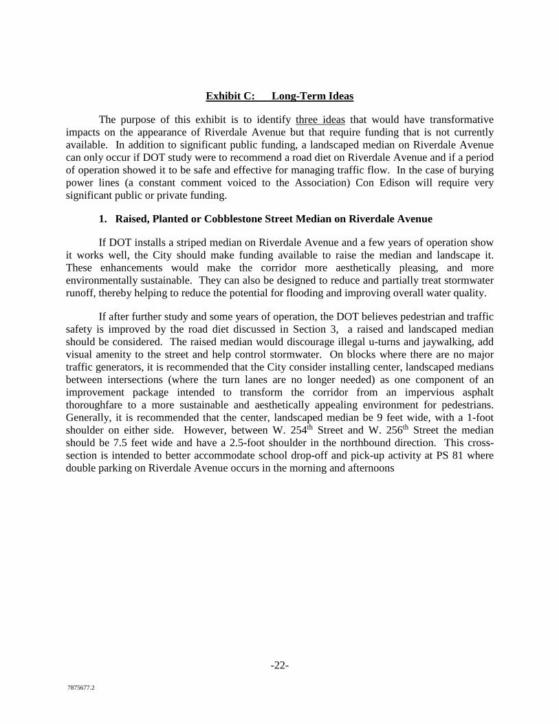
-22- 7875677.2
Exhibit C: Long-Term Ideas
The purpose of this exhibit is to identify three ideas that would have transformative impacts on the appearance of Riverdale Avenue but that require funding that is not currently available. In addition to significant public funding, a landscaped median on Riverdale Avenue can only occur if DOT study were to recommend a road diet on Riverdale Avenue and if a period of operation showed it to be safe and effective for managing traffic flow. In the case of burying power lines (a constant comment voiced to the Association) Con Edison will require very significant public or private funding.
1. Raised, Planted or Cobblestone Street Median on Riverdale Avenue
If DOT installs a striped median on Riverdale Avenue and a few years of operation show it works well, the City should make funding available to raise the median and landscape it. These enhancements would make the corridor more aesthetically pleasing, and more environmentally sustainable. They can also be designed to reduce and partially treat stormwater runoff, thereby helping to reduce the potential for flooding and improving overall water quality.
If after further study and some years of operation, the DOT believes pedestrian and traffic safety is improved by the road diet discussed in Section 3, a raised and landscaped median should be considered. The raised median would discourage illegal u-turns and jaywalking, add visual amenity to the street and help control stormwater. On blocks where there are no major traffic generators, it is recommended that the City consider installing center, landscaped medians between intersections (where the turn lanes are no longer needed) as one component of an improvement package intended to transform the corridor from an impervious asphalt thoroughfare to a more sustainable and aesthetically appealing environment for pedestrians. Generally, it is recommended that the center, landscaped median be 9 feet wide, with a 1-foot shoulder on either side. However, between W. 254th Street and W. 256th Street the median should be 7.5 feet wide and have a 2.5-foot shoulder in the northbound direction. This cross-section is intended to better accommodate school drop-off and pick-up activity at PS 81 where double parking on Riverdale Avenue occurs in the morning and afternoons
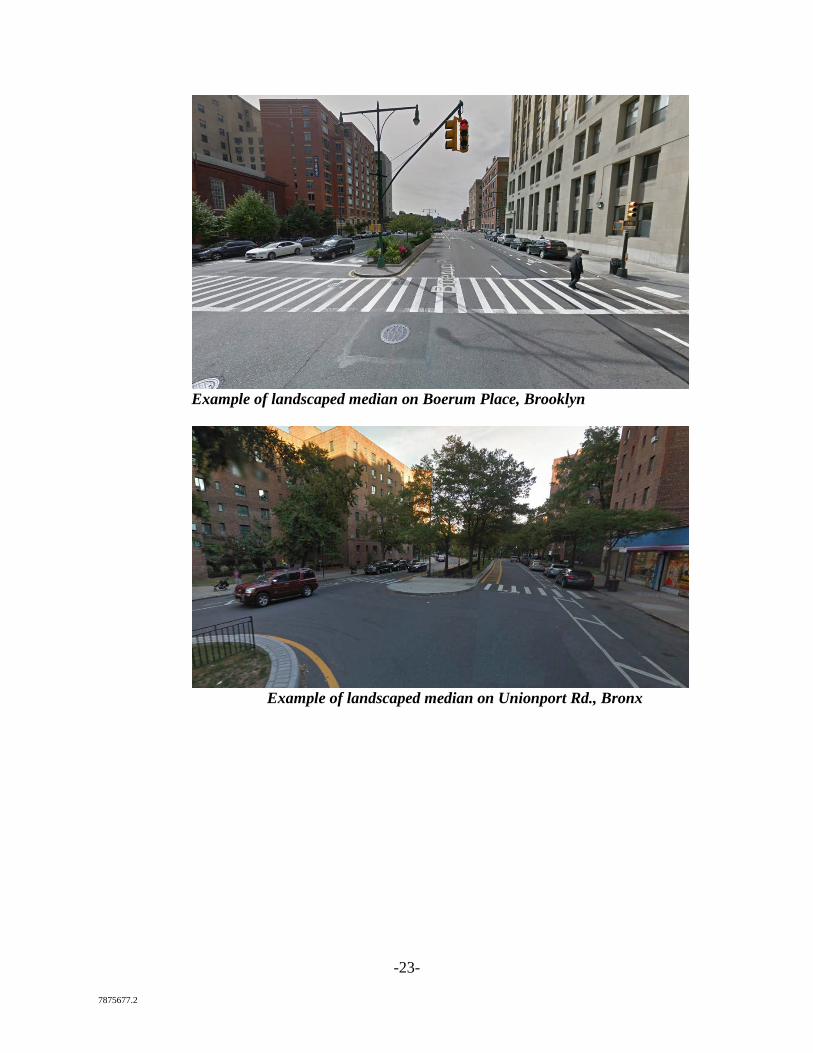
-23- 7875677.2
Example of landscaped median on Boerum Place, Brooklyn
Example of landscaped median on Unionport Rd., Bronx
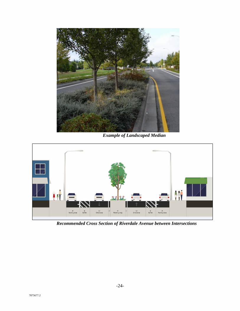
-24- 7875677.2
Example of Landscaped Median
Recommended Cross Section of Riverdale Avenue between Intersections
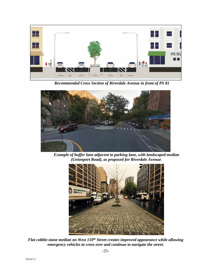
-25- 7875677.2
Recommended Cross Section of Riverdale Avenue in front of PS 81
Example of buffer lane adjacent to parking lane, with landscaped median
(Unionport Road), as proposed for Riverdale Avenue.
Flat cobble-stone median on West 110th Street creates improved appearance while allowing
emergency vehicles to cross over and continue to navigate the street.
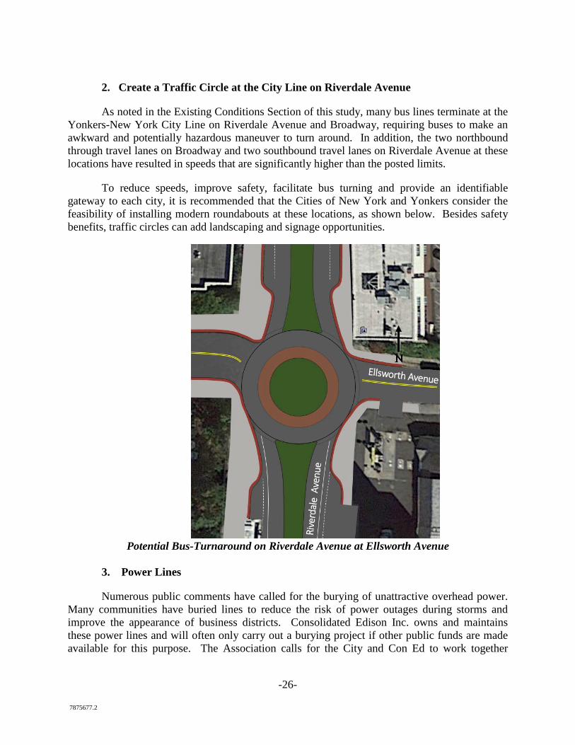
-26- 7875677.2
2. Create a Traffic Circle at the City Line on Riverdale Avenue
As noted in the Existing Conditions Section of this study, many bus lines terminate at the Yonkers-New York City Line on Riverdale Avenue and Broadway, requiring buses to make an awkward and potentially hazardous maneuver to turn around. In addition, the two northbound through travel lanes on Broadway and two southbound travel lanes on Riverdale Avenue at these locations have resulted in speeds that are significantly higher than the posted limits.
To reduce speeds, improve safety, facilitate bus turning and provide an identifiable gateway to each city, it is recommended that the Cities of New York and Yonkers consider the feasibility of installing modern roundabouts at these locations, as shown below. Besides safety benefits, traffic circles can add landscaping and signage opportunities.
Potential Bus-Turnaround on Riverdale Avenue at Ellsworth Avenue
3. Power Lines
Numerous public comments have called for the burying of unattractive overhead power. Many communities have buried lines to reduce the risk of power outages during storms and improve the appearance of business districts. Consolidated Edison Inc. owns and maintains these power lines and will often only carry out a burying project if other public funds are made available for this purpose. The Association calls for the City and Con Ed to work together
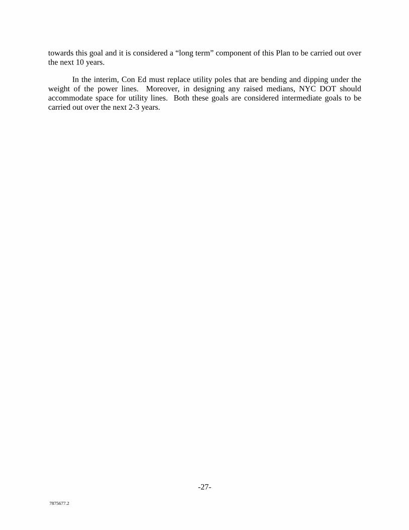
-27- 7875677.2
towards this goal and it is considered a “long term” component of this Plan to be carried out over the next 10 years.
In the interim, Con Ed must replace utility poles that are bending and dipping under the weight of the power lines. Moreover, in designing any raised medians, NYC DOT should accommodate space for utility lines. Both these goals are considered intermediate goals to be carried out over the next 2-3 years.
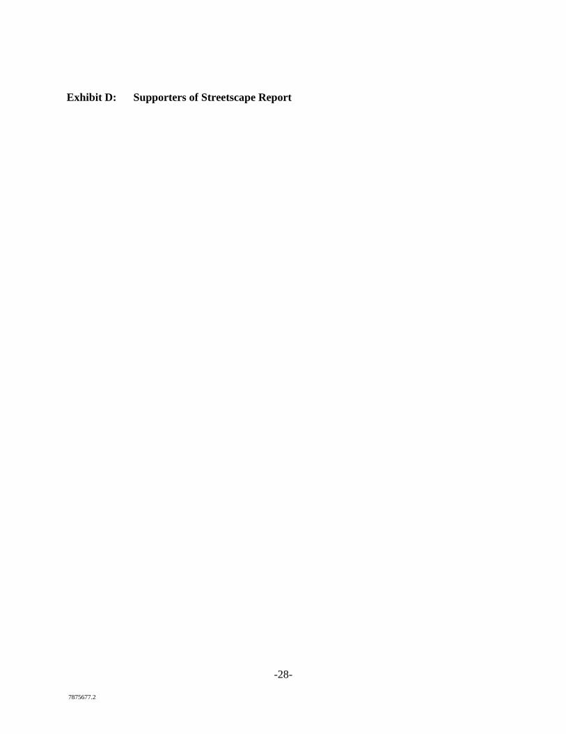
-28- 7875677.2
Exhibit D: Supporters of Streetscape Report
-29- 7875677.2
The persons, groups and institutions listed below support the goals of the 2017 Riverdale Streetscape Report to ensure that Riverdale and Mosholu Avenues are safe, environmentally sustainable and pedestrian friendly streets for the community. They call upon the City and State, including the NYC Department of Transportation, to work with the N. Riverdale Business Association and other community stakeholders to study and fund improvements to streets, sidewalks and public spaces to achieve these goals. This list will be updated with new supporters from time to time and is current as of July 1, 2017.
Local Institutions
College of Mount Saint Vincent
Hebrew Home for the Aged
Skyview Property Owners Association
Fieldston Property Owners Association
SAR Academy
SAR High School
Wave Hill
Businesses
Addeo’s Riverdale Pizza
Anthony J. Cugini Jr. Esq.
Bronx Arts Ensemble
Brown’s Jewelers
Chestnut Financial Services
Cora Hardware & Housewares
Douglas Elliman-Mary Phelan Kavanagh
Edward Jones Financial Services
Elisa Contemporary Art
Magali Capi, Halstead Properties Riverdale LLC-
Lorraine Coyle-Attorney at Law
Mario Bulfamante & Sons
-30- 7875677.2
Mathnaisum of Riverdale
Minuteman Press
MOMO Local Locksmith
New Visions Home Improvement
River Videos LLC
Riverdale Family Orthodontics
Joan Kuzniar, Robert E. Hill Realty
Kristen Hacket, Robert E. Hill Realty
Skyview Wines & Spirits
State Farm Agent—John Ciorra
Vacuum World Stores, Inc.
Warriors TaeKwonDo
Individuals
Christopher Rizzo, Esq., Carter Ledyard & Milburn LLP
Giordana Avila
Damian McShane
Lori Weiss
David Quart
Neal Mayer
Jeremy Jutkowitz
Trish Shortell
Maurice O'Connell
Joe Shortell
Margaret (Peggy) Shortell
Michael X Martin
-31- 7875677.2
Shauna Hicks
Sean Gregory
Anne Gregory
Melissa Meltzer
Hank Cardarelli
Tatyana Gourov
Paul Slavashevich
Selma Spieler
Diego Suarez
John Martello
City-wide Organizations
Municipal Art Society of New York
Pratt Center for Community Development
-32- 7875677.2
Exhibit E: VHB Analysis of Riverdale Avenue (at www.riverdalebronx.nyc)
-33- 7875677.2
Exhibit F: NYC DOT Presentation Regarding Vision Zero Program (see www.riverdalebronx.nyc)
-34- 7875677.2
Exhibit G: NYC DOT Report Regarding Vision Zero Successes in Other Communities (see www.riverdalebronx.nyc)
-35- 7875677.2
Exhibit H: NYC DOT Statistics Regarding Safety and Business Improvements (see www.riverdalebronx.nyc)
-36- 7875677.2
NOTICE
This report was prepared by VHB Engineering, Surveying and Landscape Architecture,
P.C. and Carter Ledyard & Milburn LLP in the course of performing work contracted for and sponsored by the New York State Energy Research and Development Authority (NYSERDA) and the North Riverdale Merchant & Business Association (hereafter the “Sponsors”). The opinions expressed in this report do not necessarily reflect those of the Sponsors and the State of New York, and reference to any specific product, service, process, or method does not constitute an implied or expressed recommendation or endorsement of it. Further, the Sponsors, the State of New York, and the contractor make no warranties or representations, expressed or implied, as to the fitness for particular purpose or merchantability of any product, apparatus, or service, or the usefulness, completeness, or accuracy of any processes, methods, or other information contained, described, disclosed, or referred to in this report. The Sponsors, the State of New York, and the contractor make no representation that the use of any product, apparatus, process, method, or other information will not infringe privately owned rights and will assume no liability for any loss, injury, or damage resulting from, or occurring in connection with, the use of information contained, described, disclosed, or referred to in this report.
NYSERDA makes every effort to provide accurate information about copyright owners and related matters in the reports we publish. Contractors are responsible for determining and satisfying copyright or other use restrictions regarding the content of the reports that they write, in compliance with NYSERDA’s policies and federal law. If you are the copyright owner and believe a NYSERDA report has not been properly attributed your work to you or has used it without permission, please email [email protected].
The Association prepared this report during the period January 1, 2015 to February 1, 2017 through a grant from NYSERDA through its Clean Greener Communities Program (Grant CGC 39588). The Association expects that the ideas in this report will continue to be refined in 2017 and 2018 through dialogue with the NYC Department of Transportation and community members.