remotely operated vehicle surveys in deepwater...remotely operated vehicle surveys in deepwater this...
TRANSCRIPT

UNITED STATES DEPARTMENT OF THE INTERIOR MINERALS MANAGEMENT SERVICE
GULF OF MEXICO OCS REGION
NTL No. 2003-G03 Effective Date: January 23, 2003
NOTICE TO LESSEES AND OPERATORS OF FEDERAL OIL, GAS, AND SULPHUR LEASES IN THE OUTER CONTINENTAL SHELF, GULF OF MEXICO REGION
Remotely Operated Vehicle Surveys in Deepwater
This Notice to Lessees and Operators (NTL) supersedes NTL No. 2001-G04, effective June 1, 2001, and is being issued to provide for remotely operated vehicle (ROV) surveys in an eighteenth grid area, covering a portion of the Eastern Planning Area of the Gulf of Mexico. The NTL is issued according to 30 CFR 250.103 and provides guidance with regard to ROV surveys and reports in deepwater areas (water depths greater than 400 meters) of the Gulf of Mexico.
Introduction and Background
The Minerals Management Service (MMS) Gulf of Mexico OCS Region (GOMR) has developed a strategy to ensure sound National Environmental Policy Act (NEPA) compliance for postlease activities in deepwater areas of the Central Planning Area, the Western Planning Area, and a portion of the Eastern Planning Area of the Gulf of Mexico. This strategy is outlined in a document that you can access on the Internet at http://www.gomr.mms.gov/homepg/regulate/environ/ea_grid/NEPADWSTRATEGY.PDF
The strategy was developed because the MMS GOMR is concerned that activities related to development in deepwater areas may have localized impacts on benthic communities, if such communities exist near the well or well cluster (template) site. These localized impacts are described in the report, “MMS Deepwater Operations and Activities Environmental Assessment” (MMS 2000-001).
To carry out this deepwater strategy, the MMS GOMR needs information to verify the effectiveness of existing requirements and mitigations. Accordingly, under the authority found at 30 CFR 250.203(o) and 30 CFR 250.204(s), the MMS has established a program to acquire information from ROV surveys you conduct both before and after certain activities in deepwater areas of the Gulf of Mexico.
The MMS GOMR will continue to approve OCS plans based on existing information regarding the general nature of the seafloor in deepwater areas. If the ROV survey information indicates that previously unknown, high-value bottom communities exist, such

information could lead to future alterations in the review process; however, it would not affect the current operation.
ROV Survey Plans
Include an ROV survey plan as an integral part of each Exploration Plan (EP) that proposes activities in the deepwater area of the Central Planning Area, the Western Planning Area, and a portion of the Eastern Planning Area of the Gulf of Mexico. Submit also an ROV survey plan with the first Development Operations Coordination Document (DOCD) proposing a surface structure in each of 18 grid areas. (See Attachment No. 1, Grid Map for ROV Surveys, which shows the 18 established grid areas.) Include the following information in each ROV survey plan:
1. a statement that you are familiar with the ROV survey and reporting provisions of this NTL;
2. a brief description of the survey you plan to conduct, including timeframes, proposed transects, and the equipment you will use; and
3. a statement that you will make biological and physical observations as described in this NTL and the ROV survey form during two periods of operations:
a. Prespudding (survey performed from the facility) and b. Postdrilling (prior to facility removal).
The GOMR will notify you in the approval letter for your EP or DOCD whether or not you will need to actually conduct the ROV survey you propose. The GOMR will base this decision on whether the grid area that contains your proposed activities has already received adequate ROV survey coverage.
Before you submit an EP, you may consult the aforementioned Internet address for information about the location and status of previously conducted and ongoing ROV surveys. When MMS determines that sufficient ROV information has been gathered for a particular grid, the website will indicate that all subsequent EP’s proposing activities in that grid need not contain an ROV survey plan. If that is the case, provide a statement indicating this information in your EP in lieu of the ROV survey plan.
Performing an ROV Survey
1. Perform a visual survey of the seafloor in the vicinity of your proposed well or well cluster (template) site using an ROV equipped with video imaging capabilities.
2. For each well or well cluster site, conduct this ROV survey on two separate occasions, one immediately before you begin your activities and the other immediately after you complete all activities at the site.

3
3. Run the ROV along at least six transects. Make sure that each of the six excursions extends at least 100 meters from the launch point and that at least one transect passes directly over or very near the well or well cluster site. We suggest that the transect pattern consist of track lines located at 60-degree intervals.
4. Videotape the seafloor continuously during the entire survey. You may want to obtain additional imagery, such as scanning sonar, that may help depict bottom conditions.
5. Run the ROV close enough to the seafloor so that you can observe and identify relatively small animals and features (one inch and larger) on the resulting videotape. When you encounter each type of animal for the first time, stop the ROV momentarily so that you can take close-up video footage. Try also to get close-up images of each bottom type and other interesting features on the videotape as they are encountered. Additional detail concerning how to conduct the surveys, along with answers to common questions, can be found on the website mentioned above.
Recording Information from Your ROV Surveys
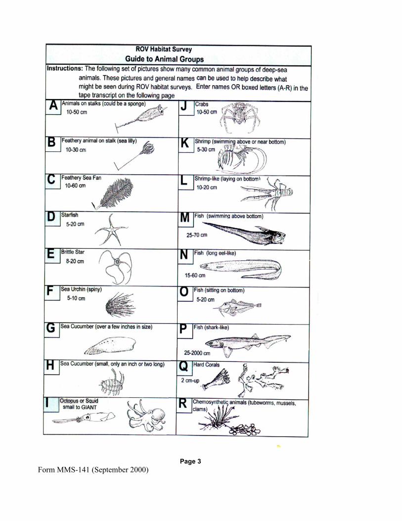
Use the ROV Survey Report (Form MMS-141) or a reasonable facsimile to record basic biological and physical information from your observations of the videotape during both of the ROV survey excursions (see Attachment No. 2). If you prefer, you can download a copy of this form from the aforementioned website. Log all major events, including transect starts and stops, and visual sightings of deepwater animals and bottom conditions on the ROV Survey Log Sheet on page 2 of Form MMS-141. No scientific expertise is required to do this; simply do the best job possible. In describing your observations, you can refer to the pictures of many common deep-sea animal groups and seafloor types on pages 3 and 4 of Form MMS-141, or just provide simple descriptions.
We have found that the seafloor is generally a rather featureless plain with relatively few visible animals and minimal currents. Ensure that you provide an account of the types of animals you do encounter and the appearance of the seafloor, such as color and texture. We are interested in all observations of animals, indications of currents such as ripple marks, and bottom types. Of particular interest is your observation of any hardbottom areas or outcrops with attached animals.
For additional information on the appearance of chemosynthetic communities, consult the following websites: http://www.gomr.mms.gov/homepg/regulate/environ/chemo/chemo.html and http://www.bio.psu.edu//cold_seeps/index.html
Show the time and counter number for each of these observations. Show the tracks in the survey report with transect numbers, times, and bearings indicated so that video images may be later located in relation to the well or well cluster site and using the videotape timelines.

4
Submitting the Results of an ROV Survey
Submit the completed Form MMS-141 or facsimile to the GOMR within 60 days after you complete the final ROV survey. Submit also, all of the videotapes and any other imagery you may have obtained, such as ROV scanning sonar data, that could help depict bottom conditions. Mail the form and videotapes/sonar data to the address below:
U.S. Department of the Interior Minerals Management Service Office of Field Operations Attention: Plans Section (MS 5230) 1201 Elmwood Park Boulevard New Orleans, Louisiana 70123-2394
Paperwork Reduction Act of 1995 Statement
The information collection referred to in this NTL provides clarification, description, or interpretation of requirements contained in 30 CFR 250, Subpart B. The Office of Management and Budget (OMB) approved the information collection requirements for these regulations and assigned OMB Control No. 1010-0049. This NTL does not impose additional information collection requirements subject to the Paperwork Reduction Act of 1995.
Contacts
Contact Mr. Nick Wetzel ((504) 736-2419) of the GOMR Plans Section if you have any questions concerning ROV survey plans or EP’s and DOCD’s. Contact either Dr. Robert Rogers ((504) 736-2898) or Mr. Greg Boland ((504) 736-2740) of the GOMR Environmental Sciences Section if you have any questions regarding ROV surveys and reporting.
Chris C. Oynes Regional Director
Attachments
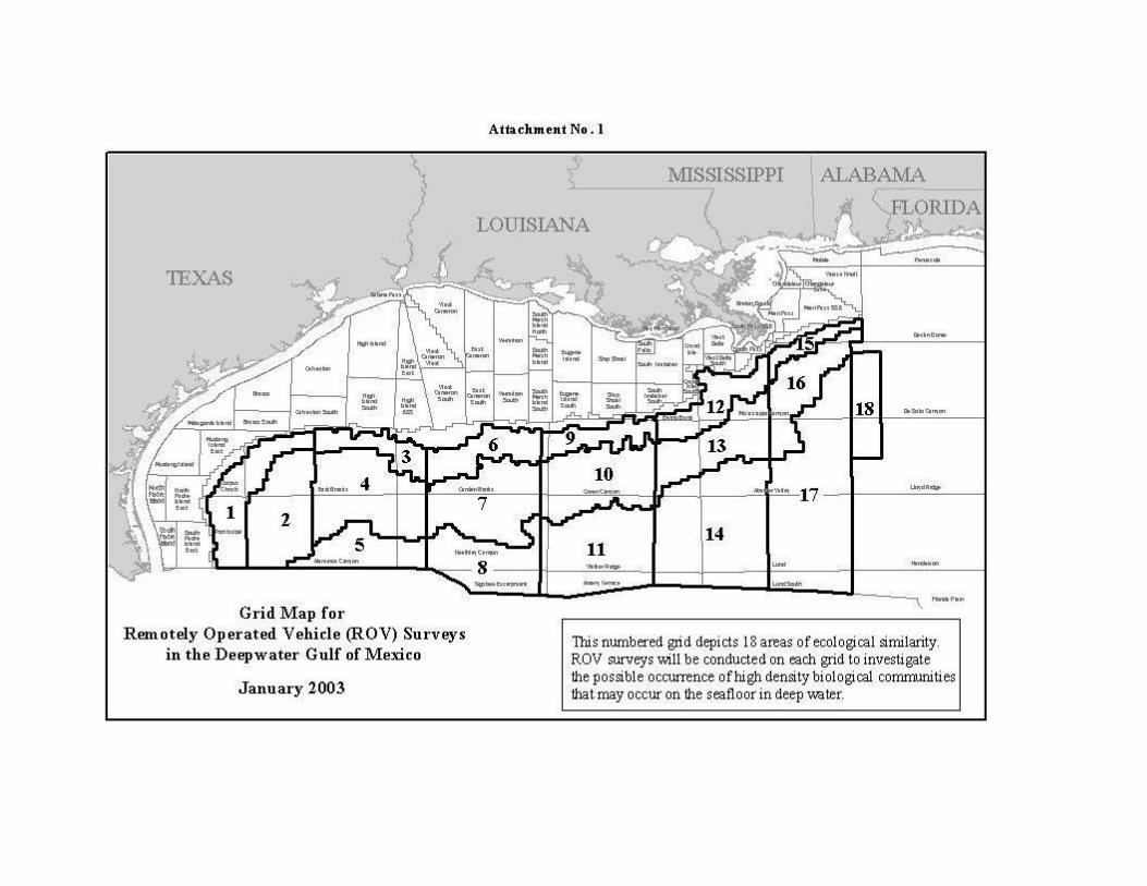
Attachment No. l
l\/IISSISSIPPI ALABA1v1A \. ,FLORIDA
LOUISIANA
1EXAS
14 11
Grid Map for Remotely Operated Vehicle (ROV) Surveys This nwnbered grid depicts 18 areas of ecological similarity.
in the Deepwater Gulf of Mexico ROV surveys will be conducted on each grid to investigate.. the possible occurrence ofhigh density biological comnruruues
January 2003 that may occur on the seafloor in deep water.

OCS Lease # Area/Block # MMS Control # Date ROV Operator Location: Lat.___________ Long.____________ Facility Name Water Depth
Example Survey Pattern Your Actual Survey Pattern Bearing (degrees) and Distance (meters) Bearing (degrees) and Distance (meters)
At least one transect should pass over or near the well or well cluster site (indicate location).
Form MMS-141 (September 2000) Page 1
A. Instructions: The Minerals Management Service is requesting that selected operators perform a limited ROV visual habitat survey before and after operations. This survey report form is to be used for recording basic information and observations made during two sets of excursions of an ROV from the drilling rig or platform to a minimum distance of 100 meters from the well site.
B. The ROV Survey Report consists of:1). Recorded information on this ROV Survey Report Form. 2). Video tape (VHS) of bottom throughout deployment. 3). Any additional imagery that may help depict bottom conditions such as scanning sonar data. This data set is to be sent to the address on the last page of this report form.
C. Two separate deployments are required.1). Prior to any activities. 2). After all operations have been completed.
ROV Transect Information The Figures below depict a suggested SURVEY PATTERN and a blank space for a sketch of the actual survey tracks that were used. Sketch in your best estimate of your actual surveys with bearings and distances.
Attachment No. 2
MMS U.S. Department of the Interior OMB Control Number 1010-0049 Minerals Management Service OMB Approval Expires 9/30/2003
ROV Survey Report

Instructions: Similar to standard ROV operations, log in all major events (examples: start transect, animals sighted, beginning and end of bottom features, currents, etc.). See page 3 for names of many common deep-sea animal groups. Of particular interest are any rocky or hard bottoms and attached animals.
Enter Elapsed Time from beginning of tape and description of EVENT or OBSERVATION Time Counter
# Description Example
O:55 135 Z with 1 N and 3Q, tan sediment type S. OR this style;
Large 2 ft. rock with an eel-like fish and 3 small corals on rock, tan bottom mud, a few burrows
IMPORTANT: If any rock outcrops or hardbottom is seen and there are any living animals growing on it, record on this page. In-house ROV log sheets can be used, or copy this form as necessary.
ROV Survey Log Sheet Tape Transcript
Form MMS-141 (September 2000) Page 2
Page 3 Form MMS-141 (September 2000)

ROV Habitat Survey
Guide to Physical Features
Small isolated outcrops A few inches to a foot or two high
Page 4
Form MMS-141 (September 2000)
Summary Sheet for ROV Pilot and Navigator The Minerals Management Service (MMS) regulates the development of Outer Continental Shelf (OCS) oil and natural gas resources, and strives for operations that are both safe and environmentally sound. Several activities related to development in deepwater may have localized impacts on benthic communities, if such communities exist near the facility.
An ROV survey is required of selected operators as a verification of the effectiveness of existing MMS environmental reviews and mitigations imposed to avoid impacts to certain types of seafloor biologic communities. The ROV survey consists of recording biological and physical information on this ROV survey form and submitting the forms and videotapes of the transects and any additional imagery that may help depict bottom conditions such as ROV scanning sonar data.
Conduct the two ROV surveys and complete pages 1 and 2, documenting basic visual sightings of deepwater animals and bottom conditions. What we are looking for is an account of the types of animals present and the appearance of the bottom such as color and texture. No scientific expertise is required, simply do the best job possible using the pictures or simple descriptions. We have found that the seafloor is generally a rather featureless plain with relatively few visible animals and minimal currents. We are interested in all observations of animals and indications of currents such as ripple marks and bottom types. Of particular interest is the observation of hardbottom areas or outcrops with any attached animals.
Fly the ROV close enough to the bottom so that relatively small animals and features (one inch and larger) can be observed and identified on the resulting videotape. Suggested track lines at 60-degree intervals are depicted on page 1. This is just a suggested pattern, the important requirements being that each of the six excursions extend at least 100 meters from the launch point and that a minimum of one transect pass directly over or near the well or well cluster (template) site. Show the tracks in the survey report with transect numbers, times, and bearings indicated so that video images can be later located in relation to the well or well cluster site and using the videotape timelines. Close-up shots of individual animals or new bottom types are very helpful.
For operators interested in becoming familiar with the appearance of chemosynthetic communities, there are other sites, including one maintained by MMS, that contain excellent images: http://www.gomr.mms.gov/homepg/regulate/environ/chemo/chemo.html http://www.bio.psu.edu//cold_seeps/index.html
Paperwork Reduction Act of 1995 (PRA) Statement: The PRA (44 U.S.C. Chapter 35) requires MMS to inform you that we collect the information on this form to identify high-density biological communities that may occur on the seafloor in deep water and, if such areas are found, to help design mitigation measures to avoid them in the future. The survey will help to assess the effectiveness of existing avoidance criteria and expand the knowledge base regarding the benthic habitats of the deep-water seafloor. Authority for collecting this information is 30 CFR 250.203(o) and 250.204(s).
An agency may not conduct or sponsor and a person is not required to respond to, a collection of information unless it displays a currently valid OMB Control Number. The Office of Management and Budget (OMB) approved the collection of information required under 30 CFR, subpart B (OMB control number 1010-0049). Responses are mandatory.
Public reporting burden for this form is estimated to average 2 hours, including the time for reviewing instructions, gathering and maintaining data, and completing and reviewing the form. Direct comments regarding the burden estimate or any other aspect of this information collection to the Information Collection Clearance Officer, Mail Stop 4230, Minerals Management Service, 1849 C Street, N.W., Washington, DC 20240.
Form MMS-141 (September 2000) Page 5

Upon completion of the two separate ROV deployments, please mail this form and videotapes/sonar data to:
Office of Field Operations, Plans Section MS 5230
Department of the Interior Minerals Management Service 1201 Elmwood Park Boulevard New Orleans, Louisiana 70123
Information Contacts: Gregory Boland or Robert Rogers
Leasing and Environment Environmental Sciences Section (504) 736-2740 or (504) 736-2898