registration document (class 2 undertaking) goldboro lng ... · pdf fileregistration document...
TRANSCRIPT

REGISTRATION DOCUMENT (CLASS 2 UNDERTAKING)
GOLDBORO LNG PROJECT
- NATURAL GAS LIQUEFACTION PLANT AND MARINE TERMINAL
Submitted to: Nova Scotia Environment
5151 Terminal Road Halifax, Nova Scotia, B3J 2P8
Submitted by:
Pieridae Energy (Canada) Ltd. 1718 Argyle Street
Halifax, Nova Scotia, B3J 3N6
Prepared by AMEC Environment & Infrastructure
50 Troop Avenue, Suite 300 Dartmouth, Nova Scotia, B3B 1Z1
February 2013
TV121039
Registration Document (Class 2 Undertaking) Goldboro LNG - Natural Gas Liquefaction Plant and Marine Terminal Pieridae Energy (Canada) Ltd.
February 2013 Page i
EXECUTIVE SUMMARY Project and Proponent Pieridae Energy (Canada) Ltd. proposes to construct a liquefied natural gas (LNG) liquefaction plant and marine terminal in Goldboro, Guysborough County, Nova Scotia, referred to as the Goldboro LNG Project. The Project proposal also includes the development of a 180 MW on-site gas-fired power generation plant. The Goldboro LNG facility will have a capacity of 10 million tonnes per annum (Mtpa) (~1575 million cubic feet per day (Mcf/d)) and a gross LNG storage capacity of about 690,000 m3 in three 230,000 m3 tanks. Pieridae Energy (Canada) Ltd. (Pieridae) is a Canadian energy infrastructure development company focused on LNG opportunities. The company’s management team has extensive LNG experience and deep connections to the LNG industry worldwide. Pieridae operates as the project lead in the initial phases of development of a project. Project Site The Goldboro LNG Project (the Project) is located at the Atlantic Ocean coast, approximately 2 km from the communities of Goldboro in the west, and Drum Head in the east. The Project is situated on the same site as the LNG component of the formerly assessed Keltic Petrochemicals and LNG Facility Project (Keltic Project). The Keltic Project obtained provincial and federal EA approvals in 2007 and 2008, respectively. The Project, however, was never implemented and all approvals obtained to date have expired. Given the similarities between the Goldboro LNG Project and the Keltic Project’s LNG component, and the limited development in the Goldboro area in recent years, much of the environmental information collected for the Keltic Project is still valid for the Goldboro LNG Project. It allows for a fairly comprehensive description of the environmental site conditions at this early stage in the planning process. Environmental Assessment, Permits, Approvals Nova Scotia Environment (NSE) has determined that the Goldboro LNG Project is a Class II undertaking pursuant to the Environmental Assessment Regulations. As such, this registration document has been generated by the Proponent in order to initiate an environmental assessment process under Part IV of the Nova Scotia Environment Act and the Environmental Assessment Regulations. Given the similarities between the Keltic Project and Goldboro LNG Project, the approval history, and the Goldboro LNG assessment process under provincial legislation, the federal Environmental Assessment Agency determined that no federal environmental assessment is required under the new (2012) Environmental Assessment Act.
Registration Document (Class 2 Undertaking) Goldboro LNG - Natural Gas Liquefaction Plant and Marine Terminal Pieridae Energy (Canada) Ltd.
February 2013 Page ii
In addition to the provincial environmental assessment process, a number of provincial and federal approvals and permits will need to be obtained including permits under the Navigable Waters Protection Act and possibly an authorization pursuant to the federal Fisheries Act. Further permits will be required by NSE under Part V of the Nova Scotia Environment Act and by the Nova Scotia Utilities and Review Board (NSUARB) under the Gas Plant Facility Regulations pursuant to the Energy Resources Conservation Act. Engagement and Consultation Pieridae has initiated a program to engage Aboriginal communities during the planning and development process. To date, several meetings have been held with representatives of Aboriginal communities to introduce the Project, the Proponent, and to establish relationships for mutually beneficial future cooperation. A comprehensive consultation plan is being implemented to consult with the general public, stakeholders, local communities, and government agencies. Consultation activities to date have involved meetings with local stakeholders and provincial and federal government agencies. Public meetings were held and feedback obtained so far has been very positive and supportive. Project Description The Goldboro LNG Project comprises an onshore natural gas liquefaction plant, a marine terminal for loading carriers with LNG product, and a wharf for mooring associated support vessels and unloading materials during construction. The marine terminal will be designed to accommodate LNG carriers ranging in size from 145,000 m3 to 263,000 m3. It is envisaged that there will be between 7 and 13 LNG carriers per month docking at the facility for loading purposes. On-site storage will entail three LNG tanks. The plant will also include a 180 MW power plant and a waste water treatment facility used to treat and discharge plant water into the sea.
Table ES 1.1 Key Components & Activities for the Goldboro LNG Project
Components Description
LNG Loading Terminal Consists of a jetty trestle and access road, LNG loading berths, marginal wharf
Natural Gas Liquefaction Plant
A facility for converting 5 Million tonnes per annum (initially, increasing to 10 Mtpa) of natural gas from the Maritimes and Northeast Pipeline (M&NP) into liquefied natural gas at atmospheric pressures and approximately -162oC for export to overseas markets.
180 MW Power Plant On-site power generation to support the LNG facility and support services.
Registration Document (Class 2 Undertaking) Goldboro LNG - Natural Gas Liquefaction Plant and Marine Terminal Pieridae Energy (Canada) Ltd.
February 2013 Page iii
Components Description
Storage Tanks
Three on-site LNG storage tanks, with two being installed for the first phase. Each tank will be able to store up to a net capacity of 210,000 m3 of LNG which equates to a gross capacity of around 230,000 m3.
LNG Transport The marine terminal will be designed to accommodate LNG carriers ranging in size from 145,000 m3 to 263,000 m3;
The facility will be predominantly air cooled and as such will not require large volumes of raw, fresh water. The main users of fresh water on the Goldboro LNG Project are the firewater system, service water, and potable water. The preliminary Project layout assumes that for reasons of safety, the District and/or Province will relocate Highway 316 around the Project site. The Goldboro LNG Project will produce the following general types of emissions, discharges, and waste:
• solid waste (construction & domestic); • air emissions, including volatile organic compounds (VOCs), sulphur compounds (SOx),
nitrogen oxides (NOx), particulate matter (PM), and greenhouse gasses (GHG); • wastewater (construction, process, and domestic); and • noise.
Project design and operations will be such that all applicable environmental standards and regulations will be met. A comprehensive environmental monitoring program will be implemented to verify compliance during construction and operation phases. The LNG industry is known to have the best safety record of any of the energy industries. As such, the Project will be engineered and operated in accordance with codes and standards specifically created for LNG facilities. These codes and standards require multiple levels of safety to ensure safe and reliable operation and to reduce the risk of malfunctions to an acceptable level. Project Site, Land Use, Natural Environment The Project will be located in the Goldboro Industrial Park, near the existing Sable Offshore Energy Inc. (SOEI) gas plant. The proposed site has been zoned with an I-3 designation permitting industrial and marine terminal developments. This designation encompasses an area between 2833 and 3238 ha, of which approximately 150 ha has been allocated to Goldboro LNG. Currently, with the exception of the gas plant and an associated helicopter landing pad, there has been very little development in and around the site and the industrial park.
Registration Document (Class 2 Undertaking) Goldboro LNG - Natural Gas Liquefaction Plant and Marine Terminal Pieridae Energy (Canada) Ltd.
February 2013 Page iv
Numerous logging roads of various age crisscross most of the Project site. In addition, numerous abandoned mine workings are spread across the project area, consisting of tailings, open shafts, and pits. There are no residences or seasonal residences on the Project site. The nearest residence with its associated drive way is located about 200 m north of the Project boundary on Route 316 near Webb’s Cove. There are no major ports near the Project area. The nearest small fishing ports are Isaac’s Harbour in the west and Drum Head in the east, each approximately 2 km distant from the Project site. There are several small, unnamed streams at the Project site, of which only one is large enough to be included in a NS government topographical map. In addition, there are three ponds located in the Project area on the Red Head peninsula. Potential Interactions, Environmental Effects, Mitigation, Monitoring The Goldboro LNG Project is expected to interact with a range of environmental components. However, it is anticipated that potential adverse impacts would be generally local and small in magnitude as a result of environmentally sensitive designs and operating plans, and the implementation of a series of mitigation measures and compensation plans. To ensure that the applicable environmental standards, permit obligations, and conditions are met, Pieridae will implement a comprehensive monitoring program. This will entail such activities as monitoring air quality, effluent discharge quality, and noise levels. Adaptive management protocols will be in place to respond and correct identified anomalies and non-compliance conditions. Beneficial economic effects of the Project are anticipated to be significant and long-lasting and extend beyond the local community and region. This includes employment, training, and service opportunities during the construction phase as well as the operating phase. The Proponent intends to maximize the economic benefits by implementing policies for procurement of goods and services that favour local labour markets and suppliers.
Registration Document (Class 2 Undertaking) Goldboro LNG - Natural Gas Liquefaction Plant and Marine Terminal Pieridae Energy (Canada) Ltd.
February 2013 Page v
TABLE OF CONTENTS
PAGE
1.0 PROJECT OVERVIEW ........................................................................................................ 1 1.1 BACKGROUND AND HISTORY ................................................................................. 1 1.2 NAME, ADDRESS AND IDENTIFICATION OF THE PROPONENT ........................... 1 1.3 CORPORATE INFORMATION AND ORGANIZATION ............................................... 2 1.4 DEFINITION OF THE UNDERTAKING ....................................................................... 2 1.5 PROJECT SCHEDULE ............................................................................................... 2 1.6 PURPOSE AND NEED OF THE UNDERTAKING ...................................................... 3 1.7 LOCATION OF THE UNDERTAKING ......................................................................... 3 1.8 LAND OWNERSHIP .................................................................................................... 4 1.9 SOURCES OF PUBLIC FUNDING ............................................................................. 4
2.0 REGULATORY OVERVIEW ................................................................................................ 7 2.1 PROVINCIAL ............................................................................................................... 7 2.2 FEDERAL .................................................................................................................... 8
2.2.1 Fisheries Act .................................................................................................... 8 2.2.2 Navigable Waters Protection Act (NWPA) ....................................................... 8 2.2.3 Technical Review Process of Marine Terminal Systems in Transshipment Sites (TERMPOL) ........................................................................................................ 9
3.0 PUBLIC AND AGENCY CONSULTATION ....................................................................... 12 3.1 PUBLIC CONSULTATION STRATEGY AND OBJECTIVES .................................... 12 3.2 STAKEHOLDERS ..................................................................................................... 12 3.3 PUBLIC AND AGENCY CONSULTATION ................................................................ 13 3.4 IDENTIFIED ISSUES AND CONCERNS .................................................................. 15
4.0 ENGAGEMENT OF ABORIGINAL COMMUNITIES ......................................................... 17 4.1 STRATEGY AND OBJECTIVES ............................................................................... 17 4.2 ABORIGINAL COMMUNITIES AND STAKEHOLDERS ........................................... 17 4.3 ENGAGEMENT ACTIVITIES .................................................................................... 18 4.4 IDENTIFIED ISSUES AND CONCERNS .................................................................. 18
5.0 PROJECT/UNDERTAKING ............................................................................................... 19 5.1 PROJECT COMPONENTS, STRUCTURES, AND SITE LAYOUT .......................... 19
5.1.1 Overview, Key Components and Site Layout ................................................ 19 5.1.2 Marine Facilities ............................................................................................. 19 5.1.3 LNG Liquefaction Plant .................................................................................. 22 5.1.4 Power Plant ................................................................................................... 27 5.1.5 Route 316 Realignment ................................................................................. 27 5.1.6 Watercourse Diversions ................................................................................. 28
5.2 PROJECT ACTIVITIES ............................................................................................. 28 5.2.1 Construction Phase ....................................................................................... 28
Registration Document (Class 2 Undertaking) Goldboro LNG - Natural Gas Liquefaction Plant and Marine Terminal Pieridae Energy (Canada) Ltd.
February 2013 Page vi
5.2.2 Operational Phase ......................................................................................... 28 5.2.3 Decommissioning Phase ............................................................................... 28
5.3 RESOURCE/MATERIAL REQUIREMENTS ............................................................. 29 5.3.1 Aggregate and Fill Material ............................................................................ 29 5.3.2 Fresh Water Supply ....................................................................................... 29
5.4 WASTE MANAGEMENT, EMISSIONS ..................................................................... 29 5.5 MALFUNCTIONS AND ACCIDENTS ........................................................................ 33
5.5.1 Background Information on the Safety of LNG Trans-shipment .................... 34 5.6 HEALTH, SAFETY & ENVIRONMENTAL MANAGEMENT ...................................... 34
6.0 EXISTING ENVIRONMENT ............................................................................................... 35 6.1 REGIONAL SETTING ............................................................................................... 35
6.1.1 Physiography & Geology ............................................................................... 35 6.1.2 Climate........................................................................................................... 36
6.2 AMBIENT AIR QUALITY ........................................................................................... 37 6.3 SURFACE WATER, GROUNDWATER, AND HYDROGEOLOGY ........................... 37
6.3.1 Surface Water ................................................................................................ 37 6.3.2 Groundwater .................................................................................................. 38 6.3.3 Hydrogeology ................................................................................................ 38
6.4 FISH & FISH HABITAT.............................................................................................. 39 6.5 MARINE ENVIRONMENT ......................................................................................... 39
6.5.1 Oceanographic Conditions ............................................................................ 40 6.5.2 Marine Fish and Fish Habitat ......................................................................... 40 6.5.3 Marine Fisheries & Aquaculture ..................................................................... 41
6.6 MARINE MAMMALS ................................................................................................. 41 6.7 TERRESTRIAL VEGETATION, FLORA, AND HABITAT .......................................... 41 6.8 WETLANDS .............................................................................................................. 43 6.9 TERRESTRIAL WILDLIFE ........................................................................................ 43
6.9.1 Invertebrates (Odonates and Butterflies) ....................................................... 43 6.9.2 Vertebrates Other Than Birds ........................................................................ 43 6.9.3 Birds .............................................................................................................. 44
6.10 SPECIES AT RISK .................................................................................................... 45 6.11 LIGHTING ................................................................................................................. 46 6.12 ACOUSTIC ENVIRONMENT .................................................................................... 46 6.13 SOCIO-CULTURAL ENVIRONMENT ....................................................................... 47
6.13.1 Communities and Population ......................................................................... 47 6.13.2 Employment & Local Economy ...................................................................... 47 6.13.3 Land Use ....................................................................................................... 47 6.13.4 Transportation................................................................................................ 47 6.13.5 Water Use Including Groundwater ................................................................. 48 6.13.6 Forestry.......................................................................................................... 48 6.13.7 Agriculture...................................................................................................... 48 6.13.8 Land Ownership, Mining, and Sub-surface Rights ........................................ 48 6.13.9 Tourism .......................................................................................................... 48 6.13.10 Mi’kmaq Interests ....................................................................................... 49
Registration Document (Class 2 Undertaking) Goldboro LNG - Natural Gas Liquefaction Plant and Marine Terminal Pieridae Energy (Canada) Ltd.
February 2013 Page vii
6.13.11 Archaeology and Heritage Resources ....................................................... 49
7.0 ASSESSMENT PROCESS AND ANTICIPATED IMPACTS / BENEFITS ........................ 50 7.1 EXISTING RELEVANT ENVIRONMENTAL ASSESSMENTS .................................. 50 7.2 POTENTIAL INTERACTIONS AND IMPACTS (PRELIMINARY SCREENING) ....... 50 7.3 CUMULATIVE EFFECTS .......................................................................................... 53
7.3.1 Internal Project Components ......................................................................... 53 7.3.2 Road Upgrades and Realignments................................................................ 53 7.3.3 Regional Oil and Gas and Related Developments ........................................ 53 7.3.4 Other Projects and Activities .......................................................................... 53
7.4 CLIMATE CHANGE IMPLICATIONS ........................................................................ 53 7.5 SOCIO-ECONOMIC BENEFITS ............................................................................... 54
7.5.1 Regional Economic Benefits .......................................................................... 54 7.5.2 Regional Energy Resource Development ...................................................... 55
7.6 ANTICIPATED MITIGATION AND MONITORING .................................................... 55
8.0 REFERENCES ................................................................................................................... 57
LIST OF TABLES Table ES 1.1 Key Components & Activities for the Goldboro LNG Project ................................. ii Table 2.1: Preliminary List of Legislative and Regulatory Requirements ............................... 9 Table 3.1: Goldboro LNG Project Key Communities and Stakeholder Groups .................... 12 Table 3.2: Public and Agency Consultation Activities ........................................................... 14 Table 3.3: Key Issues / Comments ....................................................................................... 16 Table 4.1: Key Aboriginal Communities ............................................................................... 17 Table 4.2: Engagement Activities ......................................................................................... 18 Table 4.3: Key Comments and Concerns Raised by Aboriginal Communities ..................... 18 Table 5.1: Key Components - Goldboro LNG Project .......................................................... 19 Table 5.2 Process Materials Input/Output ........................................................................... 29 Table 5.3: Emissions, Discharges and Waste ...................................................................... 30 Table 6.1 Hourly Leq Range (dBA) SOE Gas Plant, Sept. 15-16, 2004 ............................. 47 Table 7.1: Potential Project Interactions With Valued Environmental Components
(VEC’s) ................................................................................................................ 51
LIST OF FIGURES Figure 1.1 Project Location ..................................................................................................... 5 Figure 1.2 Site Overview ........................................................................................................ 6 Additional Figures and Technical Drawings in Appendices
Registration Document (Class 2 Undertaking) Goldboro LNG - Natural Gas Liquefaction Plant and Marine Terminal Pieridae Energy (Canada) Ltd.
February 2013 Page viii
LIST OF APPENDICES Appendix A FIGURES: Figure 5.1 Project Footprint Figure 5.2 LNG Facility Layout Figure 5.3 LNG Jetty Layout Figure 6.1 Locations of Heritage Resources Figure 6.2 Abandoned Mine Workings Figure 6.3 Waterbodies and Wetlands Figure 6.4 Red Head Peninsula Surface Water Features Figure 6.5 Fish Habitat in the Vicinity of LNG Facilities Figure 6.6 Fishing Areas and Aquaculture Near Country Harbour Figure 6.7 Fish Habitat in Stormont Bay and Adjacent Areas Figure 6.8 Roseate Tern Foraging Sites and Foraging Survey Figure 6.9 Land Zoning Map Appendix B TECHNICAL DRAWINGS: Overall Site Plan - LNG Overall Plot Plan - LNG Overall Plot Plan - Jetty & Berths LNG Jetty - Approach Trestle Details Overall Block Flow Diagram (2 sheets) Generic Liquefaction Schematic
Registration Document (Class 2 Undertaking) Goldboro LNG - Natural Gas Liquefaction Plant and Marine Terminal Pieridae Energy (Canada) Ltd.
February 2013 Page ix
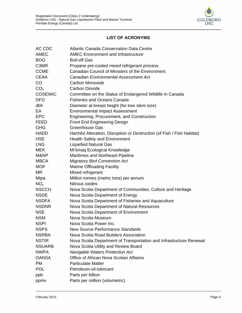
LIST OF ACRONYMS
AC CDC Atlantic Canada Conservation Data Centre AMEC AMEC Environment and Infrastructure BOG Boil-off Gas C3MR Propane pre-cooled mixed refrigerant process CCME Canadian Council of Ministers of the Environment CEAA Canadian Environmental Assessment Act CO Carbon Monoxide CO2 Carbon Dioxide COSEWIC Committee on the Status of Endangered Wildlife in Canada DFO Fisheries and Oceans Canada dbh EA
Diameter at breast height (for tree stem size) Environmental Impact Assessment
EPC FEED
Engineering, Procurement, and Construction Front End Engineering Design
GHG Greenhouse Gas HADD Harmful Alteration, Disruption or Destruction (of Fish / Fish Habitat) HSE LNG
Health Safety and Environment Liquefied Natural Gas
MEK M&NP
Mi’kmaq Ecological Knowledge Maritimes and Northeast Pipeline
MBCA Migratory Bird Convention Act MOF Marine Offloading Facility MR Mixed refrigerant Mtpa Million tonnes (metric tons) per annum NOx Nitrous oxides NSCCH Nova Scotia Department of Communities, Culture and Heritage NSDE Nova Scotia Department of Energy NSDFA Nova Scotia Department of Fisheries and Aquaculture NSDNR Nova Scotia Department of Natural Resources NSE Nova Scotia Department of Environment NSM Nova Scotia Museum NSPI Nova Scotia Power Inc. NSPS New Source Performance Standards NSRBA Nova Scotia Road Builders Association NSTIR Nova Scotia Department of Transportation and Infrastructure Renewal NSUARB Nova Scotia Utility and Review Board NWPA Navigable Waters Protection Act OANSA Office of African Nova Scotian Affaires PM Particulate Matter POL Petroleum-oil-lubricant ppb Parts per billion ppmv Parts per million (volumetric)
Registration Document (Class 2 Undertaking) Goldboro LNG - Natural Gas Liquefaction Plant and Marine Terminal Pieridae Energy (Canada) Ltd.
February 2013 Page x
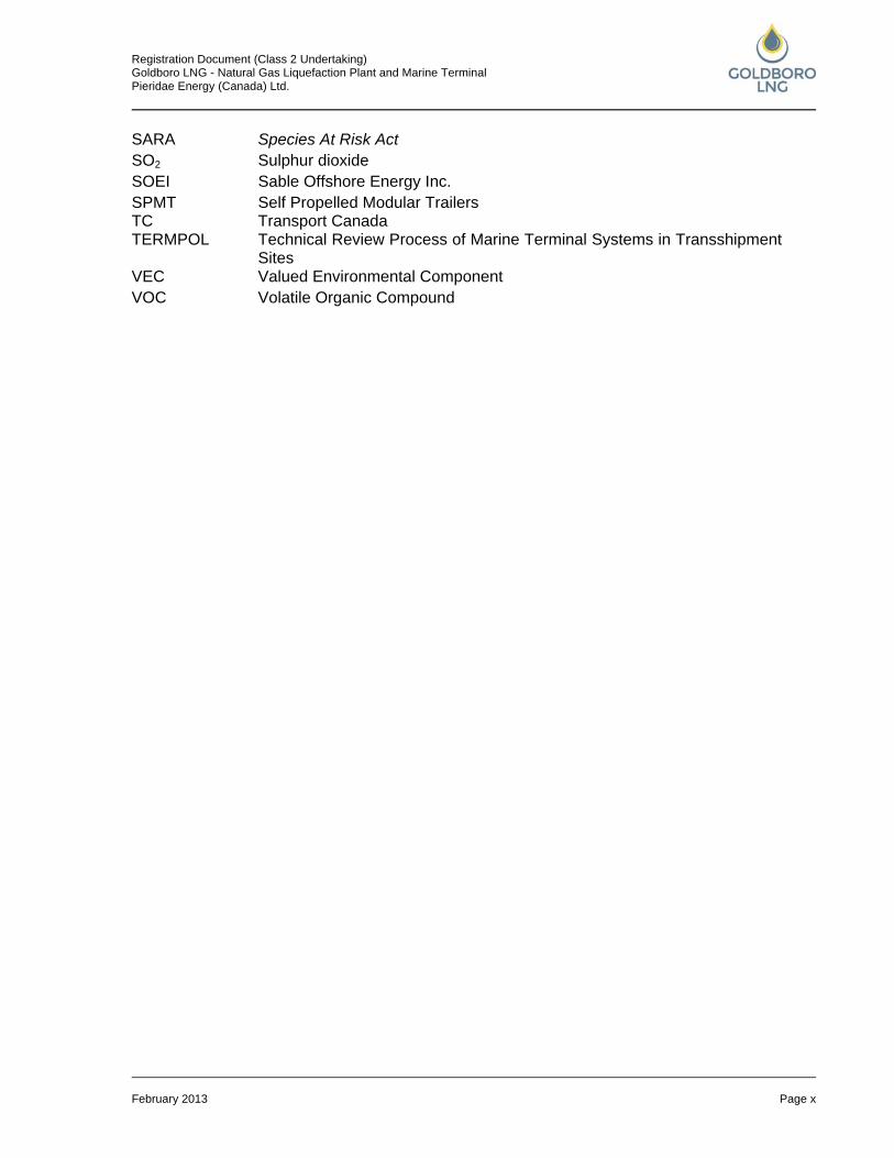
SARA Species At Risk Act SO2 Sulphur dioxide SOEI Sable Offshore Energy Inc. SPMT TC
Self Propelled Modular Trailers Transport Canada
TERMPOL Technical Review Process of Marine Terminal Systems in Transshipment Sites
VEC Valued Environmental Component VOC Volatile Organic Compound
Registration Document (Class 2 Undertaking) Goldboro LNG - Natural Gas Liquefaction Plant and Marine Terminal Pieridae Energy (Canada) Ltd.
February 2013 Page 1
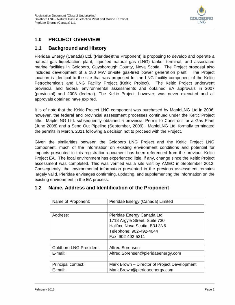
1.0 PROJECT OVERVIEW 1.1 Background and History Pieridae Energy (Canada) Ltd. (Pieridae)(the Proponent) is proposing to develop and operate a natural gas liquefaction plant, liquefied natural gas (LNG) tanker terminal, and associated marine facilities in Goldboro, Guysborough County, Nova Scotia. The Project proposal also includes development of a 180 MW on-site gas-fired power generation plant. The Project location is identical to the site that was proposed for the LNG facility component of the Keltic Petrochemicals and LNG Facility Project (Keltic Project). The Keltic Project underwent provincial and federal environmental assessments and obtained EA approvals in 2007 (provincial) and 2008 (federal). The Keltic Project, however, was never executed and all approvals obtained have expired. It is of note that the Keltic Project LNG component was purchased by MapleLNG Ltd in 2006; however, the federal and provincial assessment processes continued under the Keltic Project title. MapleLNG Ltd. subsequently obtained a provincial Permit to Construct for a Gas Plant (June 2008) and a Send Out Pipeline (September, 2009). MapleLNG Ltd. formally terminated the permits in March, 2011 following a decision not to proceed with the Project. Given the similarities between the Goldboro LNG Project and the Keltic Project LNG component, much of the information on existing environment conditions and potential for impacts presented in this registration document has been referenced from the previous Keltic Project EA. The local environment has experienced little, if any, change since the Keltic Project assessment was completed. This was verified via a site visit by AMEC in September 2012. Consequently, the environmental information presented in the previous assessment remains largely valid. Pieridae envisages confirming, updating, and supplementing the information on the existing environment in the EA process.
1.2 Name, Address and Identification of the Proponent
Name of Proponent: Pieridae Energy (Canada) Limited
Address: Pieridae Energy Canada Ltd 1718 Argyle Street, Suite 730 Halifax, Nova Scotia, B3J 3N6 Telephone: 902-492-4044 Fax: 902-492-5211
Goldboro LNG President: Alfred Sorensen E-mail: [email protected] Principal contact: Mark Brown – Director of Project Development E-mail: [email protected]
Registration Document (Class 2 Undertaking) Goldboro LNG - Natural Gas Liquefaction Plant and Marine Terminal Pieridae Energy (Canada) Ltd.
February 2013 Page 2
1.3 Corporate Information and Organization Pieridae Energy Canada Ltd. is a Canadian energy infrastructure development company focused on LNG opportunities. The company’s management team has extensive LNG experience and deep connections to the LNG industry worldwide. Pieridae operates as the project lead in the initial phases of development of a project. More information can be obtained at: www.GoldboroLNG.com
1.4 Definition of the Undertaking The Goldboro LNG Project (the Project) encompasses the development and operation of an natural gas liquefaction facility and marine terminal with a capacity of 10 million tonnes per annum (Mtpa) (~1575 million cubic feet per day) and a gross LNG storage capacity of about 690,000 m3 in three 230,000 m3 tanks (operational capacity probably closer to 615,000 m3). The Project proposal includes the development of a 180 MW on-site gas-fired power plant.
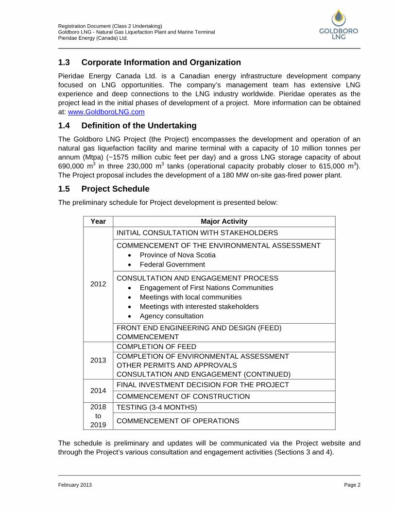
1.5 Project Schedule The preliminary schedule for Project development is presented below:
Year Major Activity
2012
INITIAL CONSULTATION WITH STAKEHOLDERS
COMMENCEMENT OF THE ENVIRONMENTAL ASSESSMENT • Province of Nova Scotia • Federal Government
CONSULTATION AND ENGAGEMENT PROCESS • Engagement of First Nations Communities • Meetings with local communities • Meetings with interested stakeholders • Agency consultation
FRONT END ENGINEERING AND DESIGN (FEED) COMMENCEMENT
2013
COMPLETION OF FEED COMPLETION OF ENVIRONMENTAL ASSESSMENT OTHER PERMITS AND APPROVALS CONSULTATION AND ENGAGEMENT (CONTINUED)
2014 FINAL INVESTMENT DECISION FOR THE PROJECT COMMENCEMENT OF CONSTRUCTION
2018 to
2019
TESTING (3-4 MONTHS)
COMMENCEMENT OF OPERATIONS
The schedule is preliminary and updates will be communicated via the Project website and through the Project’s various consultation and engagement activities (Sections 3 and 4).
Registration Document (Class 2 Undertaking) Goldboro LNG - Natural Gas Liquefaction Plant and Marine Terminal Pieridae Energy (Canada) Ltd.
February 2013 Page 3
1.6 Purpose and Need of the Undertaking The increasing demand for natural gas in the world markets, particularly in Asia, has fostered the exploration of new gas supplies. In North America, there is an increasing supply of natural gas, much of it from shale gas developments. The Goldboro LNG facility is intended for the export of North American natural gas supplies to consumers in Europe, Asia, and other developing markets. The Goldboro LNG facility is proposed for a coastal location with direct access to the M&NP pipeline, which is connected to multiple US and Canadian pipelines. The facility’s objective is to receive gas via the existing M&NP pipeline in Goldboro, liquefy, store, and load the LNG onto LNG vessels for export to markets in Europe and Asia.
1.7 Location of the Undertaking The Goldboro LNG Project is located at the Atlantic Ocean coast, approximately 2 km each way from the communities of Goldboro in the west, and Drum Head and Seal Harbour in the east (Figure 1.1). The centre of the Goldboro LNG Project site is located approximately at:
• Latitude: 45°10’N; and • Longitude: 61°38’W.
Site Overview A preliminary site layout for the Goldboro LNG Project is presented in Figure 1.2. The Project will be located in the Goldboro Industrial Park near the existing Sable Offshore Energy Inc. (SOEI) gas plant. The SOEI Pipeline runs along the eastern boundary of the industrial park and Project site. Also included is the proposed pipeline connection from the Project site to the M&NP pipeline. The preliminary Project layout assumes that for reasons of safety, the District and/or Province will relocate Highway 316 around the Project site. There are no railroad tracks, airports, or airstrips in the vicinity of the Project; however, a helicopter landing pad occasionally used by SOEI is located at the northern boundary of the Project area. Numerous logging roads of various ages crisscross most of the Project site. There are no major ports near the Project area. The nearest small fishing ports are Isaac’s Harbour in the west and Drum Head in the east, each approximately 2 km distant from the Project Site. The Project site boundaries extend to include the southern section of the Red Head peninsula, with Betty’s Cove located at southern base of the peninsula, and Webb’s Cove located the northern base, off the Project site. There are several small, unnamed streams at the Project site, of which only one is large enough to be included in a NS government topographical map. In addition, there are three ponds located in the Project area on the Red Head peninsula. They are separated from the ocean by barrier beaches. The largest, Dung Cove Pond, is freshwater and is fed by the above mentioned
Registration Document (Class 2 Undertaking) Goldboro LNG - Natural Gas Liquefaction Plant and Marine Terminal Pieridae Energy (Canada) Ltd.
February 2013 Page 4
stream. The smaller ponds are brackish or saline. Crane Lake is located along Betty’s Cove Brook, about 200 m east of the Project boundary (Figure 1.1). A number of heritage resources were detected during an Archaeological Resource Impact Study carried out in 2004, most of them associated to mining activities that were abandoned about 100 years ago. In addition, numerous abandoned mine workings are spread across the project area, consisting of tailings, open shafts, and pits. There are no residences or seasonal residences on the Project site. The nearest residence with its associated drive way is located about 200 m north of the Project boundary on Route 316 near Webb’s Cove.
1.8 Land Ownership The Goldboro LNG Project site is currently owned by the Municipality of the District of Guysborough. The site is located in the Goldboro Industrial Park which is zoned Industrial Heavy I-3 (Municipality of the District of Guysborough, Land Use By-law, 2011). I-3 zoning allows for uses such as natural gas processing, including liquefaction and gasification facilities as well as marine terminals, including wharfs and storage facilities.
1.9 Sources of Public Funding No public funding is required.
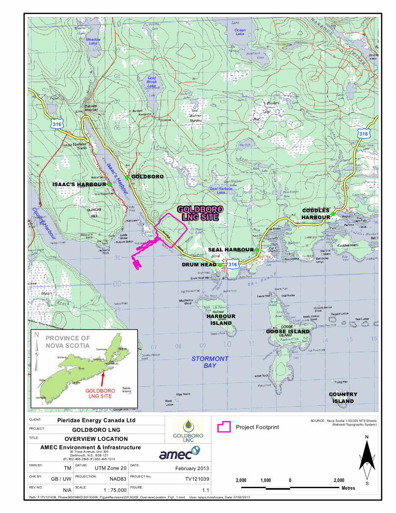
FIGURE:
DATE:DATUM:DWN BY:
PROJECTION:CHK BY:
REV NO: SCALE:
PROJECT No: TV1210391 : 75,000
NAD83UTM Zone 20
N/AGB / UW
TM
GOLDBOROLNG SITE
OceanLake
Seal HarbourLake
GoldBrookLake
COUNTRYISLAND
STORMONTBAY
Isaac's Harbour
MeadowLake
Country Harbour
£¤316
£¤316£¤316
!(
!(
!(
!(
GOOSE ISLANDHARBOURISLAND
ISAAC'S HARBOURGOLDBORO!(
DRUM HEADSEAL HARBOUR
CODDLESHARBOUR
(Project Footprint
50 Troop Avenue, Unit 300Dartmouth, N.S., B3B 1Z1
(P) 902-468-2848 (F) 902-468-1314
AMEC Environment & Infrastructure
2,000 0 2,0001,000Metres
!(
!(
!(
!(
!(
!(
!(
!(
!(
SableIs land
PROVINCE OFNOVA SCOTIA
GOLDBOROLNG SITE
Truro
Digby
Sydney
Amherst
Halifax
Yarmouth
Inverness
Ant igonish PortHawkesbury³
Path: F:\TV121039_Phase3000\MXD\20130206_FigureRevisions\20130206_OverviewLocation_Fig1_1.mxd User: tanya.morehouse, Date: 07/02/2013
SOURCE: Nova Scotia 1:50,000 NTS Sheets(National Topographic System)
1.1
February 2013
TITLE:
PROJECT:
CLIENT: Pieridae Energy Canada LtdGOLDBORO LNG
OVERVIEW LOCATION
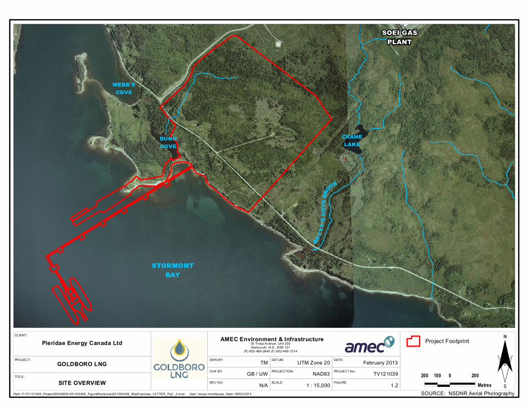
FIGURE:
DATE:DATUM:DWN BY:
PROJECTION:CHK BY:
REV NO: SCALE:
PROJECT No:
1 : 15,000NAD83
UTM Zone 20
N/AGB / UW
TMPROJECT:
TITLE:
CLIENT:
SOEI GASPLANT
WEBB'SCOVE
DUNGCOVE
CRANELAKE
BETT
Y 'S CO
VE BR
OOK
STORMONTBAY
Project Footprint50 Troop Avenue, Unit 300Dartmouth, N.S., B3B 1Z1
(P) 902-468-2848 (F) 902-468-1314
AMEC Environment & InfrastructurePieridae Energy Canada Ltd
GOLDBORO LNG200 0 200100
MetresPath: F:\TV121039_Phase3000\MXD\201302206_FigureRevisions\201300206_SiteOverview_LETTER_Fig1_2.mxd User: tanya.morehouse, Date: 06/02/2013
TV121039
SOURCE: NSDNR Aerial Photography1.2
February 2013
SITE OVERVIEW ¨
Registration Document (Class 2 Undertaking) Goldboro LNG - Natural Gas Liquefaction Plant and Marine Terminal Pieridae Energy (Canada) Ltd.
February 2013 Page 7
2.0 REGULATORY OVERVIEW There are a number of federal and provincial laws and municipal by-laws which are applicable to the Project. These are discussed below and summarized in Table 2.1 at the end of this section. In addition, there are a number of guidelines, codes, and/or industry standards relevant to the Project that will be used by the Proponent in the design, construction, and operation of the Project.
2.1 Provincial Schedule “A” of the Nova Scotia Environmental Assessment Regulations lists the undertakings that are required to undergo an environmental assessment. Proponents of such undertakings have to submit a registration document. The Schedule distinguishes Class I and Class II Undertakings. Class I undertakings are usually smaller in scale and may or may not cause significant environmental impacts or be of sufficient concern to the public. The Minister will decide if further information and/or public hearings are required. Class II undertakings are typically larger in scale and are considered to have the potential to cause significant environmental impacts and concern to the public. Following the submission of the registration document (project description), these projects require an environmental assessment report and formal public review which may include hearings. The Nova Scotia Department of Environment (NSE) has determined that the Goldboro LNG Project is a Class II undertaking, due to the proposed 180 MW power plant. This registration document has been generated by the Proponent in order to initiate an environmental assessment process. A Permit to Construct and a License to Operate from the Nova Scotia Utilities and Review Board (NSUARB) will be required pursuant to the Gas Plant Facility Regulations passed under the Energy Resources Conservation Act. These regulations set out terms and conditions of construction and operation. The Proponent will apply for a Permit to Construct after all required federal and provincial environmental approvals are obtained and will follow the Nova Scotia Department of Energy (NSDE) Code of Practice for LNG Facilities dated July 2005. The Regulations incorporate by reference CSA Z276-11, which is the current version (2011) of the CSA Liquefied Natural Gas standard. This Code of Practice provides requirements and guidance for the design, construction, operation and abandonment of land-based LNG plants and the associated jetty and marine terminal. It is intended to supplement both the requirements in the Gas Plant Facility Regulations and CSA Z276-11. A central purpose in the application of the Code of Practice is the protection of the public through the appropriate design, construction, operation, and abandonment of LNG facilities (NSDE Code of Practice for LNG Facilities, July 2005). As part of the site development, a series of approvals will be required pursuant to Part V of the Nova Scotia Environment Act and the associated Activities Designation Regulation. These approvals will be sought following the approval of the provincial environmental assessment and apply to such works as the treatment plant and wharf. A wide range of other provincial legislation and permits may be applicable, as identified in Table 2.1 below.
Registration Document (Class 2 Undertaking) Goldboro LNG - Natural Gas Liquefaction Plant and Marine Terminal Pieridae Energy (Canada) Ltd.
February 2013 Page 8
2.2 Federal As stated earlier, the Goldboro LNG Project is proposed for the same location as the Keltic Project LNG component (later referred to as MapleLNG) and is very similar in nature. MapleLNG obtained provincial and federal EA approvals (2007 and 2008 respectively) and was also issued a Permit to Construct by the NSUARB. Given these project similarities, and in recognition of the previous project approvals, the Canadian Environmental Assessment Agency (the Agency) reviewed the requirements for a federal environmental assessment pursuant to the new Canadian Environmental Assessment Act (CEAA 2012). To facilitate that review and assist in the Agency’s decision making, the Proponent submitted a comprehensive comparative description of the two projects (November 2012). This document was structured to follow the federal guide to preparing a project description (CEAA 2012: Guide to Preparing a Description of a Designated Project under the Canadian Environmental Assessment Act, CEAA, July 2012), and compared the two projects with an emphasis on the EA requirements established by CEAA 2012. The Agency reviewed the document and in an e-mail dated December 20, 2012, the Agency informed the Proponent that it determined that the Goldboro LNG Project does not require a federal EA pursuant to section 128 (1) ( c ) of CEAA 2012.
2.2.1 Fisheries Act
Section 35 of the Fisheries Act, R.S.C. 1985, c. F-14 prohibits any person from carrying on any work or undertaking that results in the harmful alteration, disruption or destruction (HADD) of fish habitat, except in accordance with an authorization issued under Section 35(2). Construction of a marine terminal facility and associated elements of the Project may require authorizations under Section 35(2). The Fisheries Act is about to be replaced by a revised and will no longer make reference to HADD thus limiting the requirements for assessments and authorizations. In consultation with the federal Department of Fisheries and Oceans (DFO) in January 2013, the Proponent was informed that the administration is transitioning the application of the new Act and that the Goldboro LNG Project will be subject to both the old and new regulations. As the new legislation is being implemented its application to the Project will need to be determined. The requirements for an authorization under the Act therefore will be addressed upon the Proponent’s formal submission of an application to DFO.
2.2.2 Navigable Waters Protection Act (NWPA)
The construction of the marine terminal facility will trigger the requirement for an approval under Section 5(1) of the NWPA. Watercourse crossings for road construction, if applicable, may also require approval under Section 5(1) of the NWPA and will be addressed in separate permit application(s). The NWPA is about to be replaced by the Navigation Protection Act which will limit the requirements for assessments and authorizations required by developments at or in navigable waters. In consultation with Transport Canada (TC) Marine Safety in January 2013, the Proponent was informed that the NWPA is still in force and applicable to the Goldboro LNG Project. As such, approvals under the Act are required, the approval process is initiated with the submission of fully dimensioned drawings for all relevant project components.
Registration Document (Class 2 Undertaking) Goldboro LNG - Natural Gas Liquefaction Plant and Marine Terminal Pieridae Energy (Canada) Ltd.
February 2013 Page 9
2.2.3 Technical Review Process of Marine Terminal Systems in Transshipment Sites (TERMPOL)
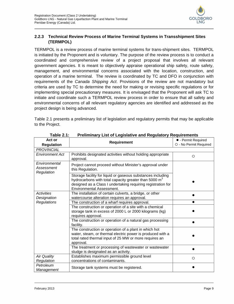
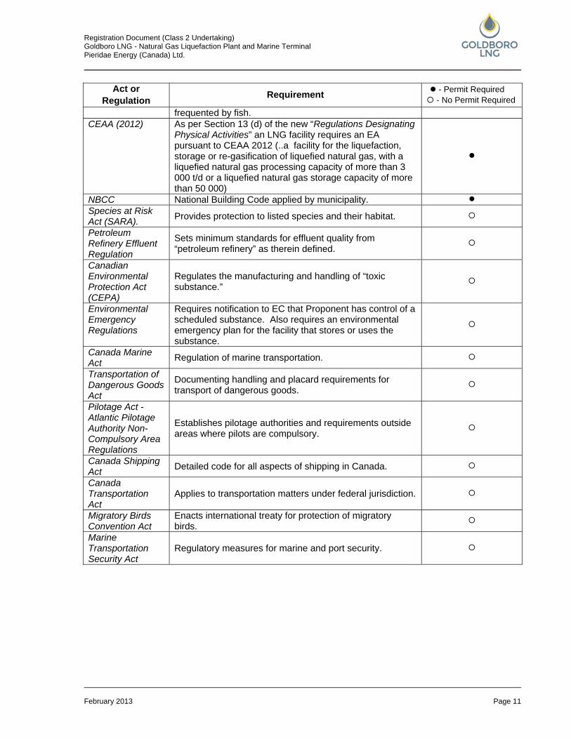
TERMPOL is a review process of marine terminal systems for trans-shipment sites. TERMPOL is initiated by the Proponent and is voluntary. The purpose of the review process is to conduct a coordinated and comprehensive review of a project proposal that involves all relevant government agencies. It is meant to objectively appraise operational ship safety, route safety, management, and environmental concerns associated with the location, construction, and operation of a marine terminal. The review is coordinated by TC and DFO in conjunction with requirements of the Canada Shipping Act. Provisions of the review are not mandatory but criteria are used by TC to determine the need for making or revising specific regulations or for implementing special precautionary measures. It is envisaged that the Proponent will ask TC to initiate and coordinate such a TERMPOL review process in order to ensure that all safety and environmental concerns of all relevant regulatory agencies are identified and addressed as the project design is being advanced. Table 2.1 presents a preliminary list of legislation and regulatory permits that may be applicable to the Project.
Table 2.1: Preliminary List of Legislative and Regulatory Requirements Act or
Regulation Requirement - Permit Required - No Permit Required
PROVINCIAL Environment Act Prohibits designated activities without holding appropriate
approval.
Environmental Assessment Regulation
Project cannot proceed without Minister’s approval under this Regulation.
Storage facility for liquid or gaseous substances including hydrocarbons with total capacity greater than 5000 m3 designed as a Class I undertaking requiring registration for Environmental Assessment.
Activities Designation Regulations
The installation of certain culverts, a bridge, or other watercourse alteration requires an approval.
The construction of a wharf requires approval. The construction or operation of a site with a chemical
storage tank in excess of 2000 L or 2000 kilograms (kg) requires approval.
The construction or operation of a natural gas processing facility.
The construction or operation of a plant in which hot water, steam, or thermal electric power is produced with a total rated thermal input of 25 MW or more requires an approval.
The treatment or processing of wastewater or wastewater sludge is designated as an activity.
Air Quality Regulation
Establishes maximum permissible ground level concentrations of contaminants.
Petroleum Management Storage tank systems must be registered.
Registration Document (Class 2 Undertaking) Goldboro LNG - Natural Gas Liquefaction Plant and Marine Terminal Pieridae Energy (Canada) Ltd.
February 2013 Page 10
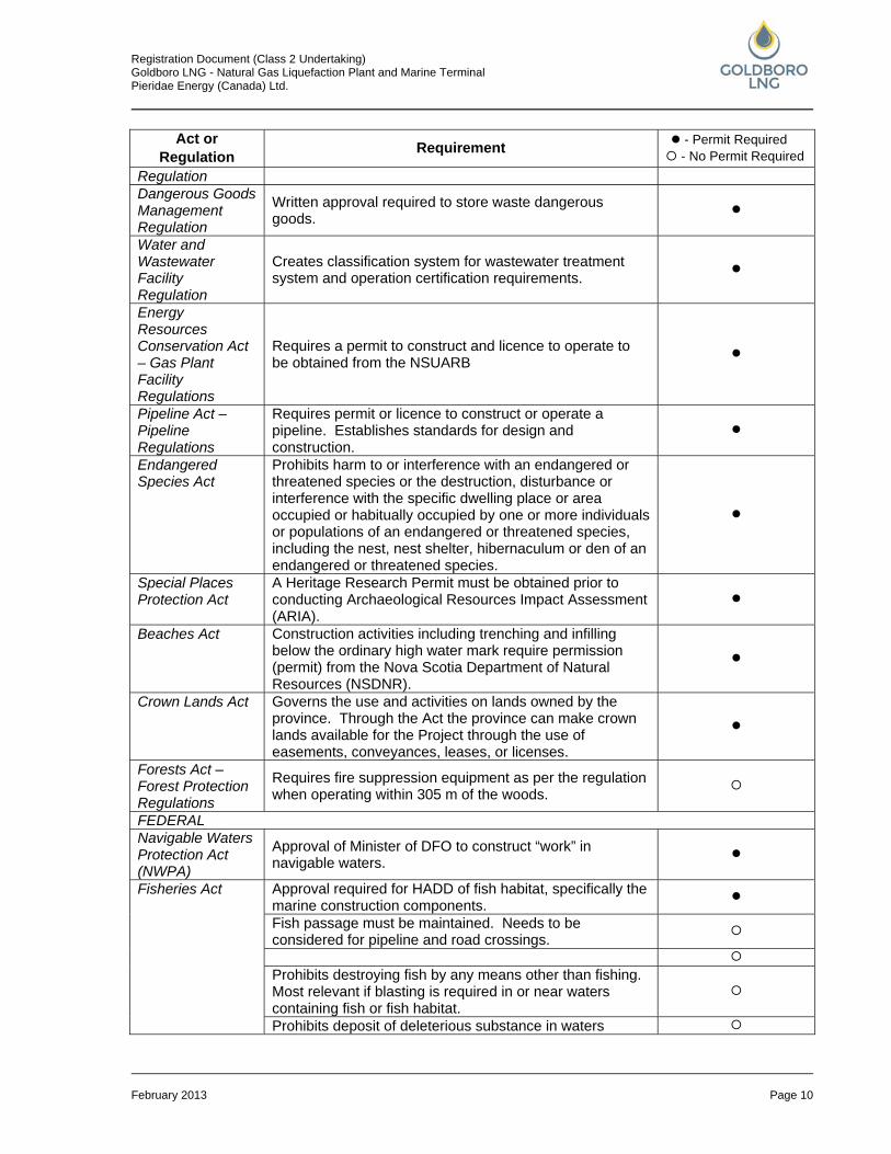
Act or Regulation Requirement - Permit Required
- No Permit Required Regulation Dangerous Goods Management Regulation
Written approval required to store waste dangerous goods.
Water and Wastewater Facility Regulation
Creates classification system for wastewater treatment system and operation certification requirements.
Energy Resources Conservation Act – Gas Plant Facility Regulations
Requires a permit to construct and licence to operate to be obtained from the NSUARB
Pipeline Act – Pipeline Regulations
Requires permit or licence to construct or operate a pipeline. Establishes standards for design and construction.
Endangered Species Act
Prohibits harm to or interference with an endangered or threatened species or the destruction, disturbance or interference with the specific dwelling place or area occupied or habitually occupied by one or more individuals or populations of an endangered or threatened species, including the nest, nest shelter, hibernaculum or den of an endangered or threatened species.
Special Places Protection Act
A Heritage Research Permit must be obtained prior to conducting Archaeological Resources Impact Assessment (ARIA).
Beaches Act Construction activities including trenching and infilling below the ordinary high water mark require permission (permit) from the Nova Scotia Department of Natural Resources (NSDNR).
Crown Lands Act Governs the use and activities on lands owned by the province. Through the Act the province can make crown lands available for the Project through the use of easements, conveyances, leases, or licenses.
Forests Act – Forest Protection Regulations
Requires fire suppression equipment as per the regulation when operating within 305 m of the woods.
FEDERAL Navigable Waters Protection Act (NWPA)
Approval of Minister of DFO to construct “work” in navigable waters.
Fisheries Act Approval required for HADD of fish habitat, specifically the marine construction components.
Fish passage must be maintained. Needs to be considered for pipeline and road crossings.
Prohibits destroying fish by any means other than fishing.
Most relevant if blasting is required in or near waters containing fish or fish habitat.
Prohibits deposit of deleterious substance in waters
Registration Document (Class 2 Undertaking) Goldboro LNG - Natural Gas Liquefaction Plant and Marine Terminal Pieridae Energy (Canada) Ltd.
February 2013 Page 11
Act or Regulation Requirement - Permit Required
- No Permit Required frequented by fish.
CEAA (2012) As per Section 13 (d) of the new “Regulations Designating Physical Activities” an LNG facility requires an EA pursuant to CEAA 2012 (..a facility for the liquefaction, storage or re-gasification of liquefied natural gas, with a liquefied natural gas processing capacity of more than 3 000 t/d or a liquefied natural gas storage capacity of more than 50 000)
NBCC National Building Code applied by municipality. Species at Risk Act (SARA). Provides protection to listed species and their habitat.
Petroleum Refinery Effluent Regulation
Sets minimum standards for effluent quality from “petroleum refinery” as therein defined.
Canadian Environmental Protection Act (CEPA)
Regulates the manufacturing and handling of “toxic substance.”
Environmental Emergency Regulations
Requires notification to EC that Proponent has control of a scheduled substance. Also requires an environmental emergency plan for the facility that stores or uses the substance.
Canada Marine Act Regulation of marine transportation.
Transportation of Dangerous Goods Act
Documenting handling and placard requirements for transport of dangerous goods.
Pilotage Act - Atlantic Pilotage Authority Non-Compulsory Area Regulations
Establishes pilotage authorities and requirements outside areas where pilots are compulsory.
Canada Shipping Act Detailed code for all aspects of shipping in Canada.
Canada Transportation Act
Applies to transportation matters under federal jurisdiction.
Migratory Birds Convention Act
Enacts international treaty for protection of migratory birds.
Marine Transportation Security Act
Regulatory measures for marine and port security.

Registration Document (Class 2 Undertaking) Goldboro LNG - Natural Gas Liquefaction Plant and Marine Terminal Pieridae Energy (Canada) Ltd.
February 2013 Page 12
3.0 PUBLIC AND AGENCY CONSULTATION 3.1 Public Consultation Strategy and Objectives Pieridae’s public consultation strategy is to both effectively engage with stakeholders and fulfill the requirements of the Environmental Assessment under the Nova Scotia Environmental Assessment Regulations and associated guidelines, in particular A Proponent’s Guide to Environmental Assessment, September 2009. Pieridae is committed to open and transparent engagement using an approach that fosters a relationship of working together. Pieridae is committed to being the first and best source of information about the Project for stakeholders. A comprehensive consultation program has been developed with the following key objectives:
• to identify issues and concerns of the affected communities, stakeholder groups, and individuals;
• assist in judging the intensity of project benefits or impacts; • solicit local information or expert opinions; and • fulfill regulatory requirements.
The consultation program is intended to accompany the project planning from the early planning stages, through approvals and permitting, and construction. Pieridae also intends to continually effectively engage with all stakeholders during the operation of the facility.
3.2 Stakeholders Pieridae has identified and engaged with key local stakeholders and those with a direct interest in the Project. The range of stakeholders is expected to evolve throughout Project development to reflect varying levels of interest and issues over time. Key local communities and stakeholder groups identified as potentially affected and/or having a direct interest in the Goldboro LNG Project are listed in Table 3.1.
Table 3.1: Goldboro LNG Project Key Communities and Stakeholder Groups Federal Regulatory Stakeholders
• Environment Canada (EC) • Fisheries & Oceans Canada (DFO) • Health Canada • NRCan • Transport Canada (TC)
Provincial Regulatory Stakeholders • NS Environment, • NS Economic and Rural Development and Tourism • NS Communities, Culture, and Heritage • NS Natural Resources • NS Agriculture • NS Fisheries, and Aquaculture • NS Health and Wellness

Registration Document (Class 2 Undertaking) Goldboro LNG - Natural Gas Liquefaction Plant and Marine Terminal Pieridae Energy (Canada) Ltd.
February 2013 Page 13
Communities • Goldboro, Country Harbour • Drum Head, Isaac’s Harbour • Erinville • Salmon RiverLake Fraser Mills, and Lower Springfield • Town of Guysborough • Town of Antigonish • Rural residents of Stormont Bay from Port Hilford through Port Bickerton to the west, and
Coddles Harbour to Tor Bay to the east (in the Municipality of the District of Guysborough) Economic Stakeholders
• Guysborough County Regional Development Authority (GCRDA) • Goldboro-Isaac’s Harbour Community Development Authority • Guysborough County Inshore Fisherman Association (GCIFA) • Eastern Shore Fishermen’s Protective Association • Individual fishers and aquaculture interests in the Project area • The Antigonish Area Partnership • Antigonish Chamber of Commerce • Antigonish Regional Development Authority • Local mining industry (traffic circulation and exploration rights)
Environmental Stakeholders • Goldboro and Area Marine Protection Society • Ecology Action Centre • Canadian Parks and Wilderness Society, Nova Scotia Chapter • The Aquaculture Association of Nova Scotia • Eastern Mainland Field Naturalists • The Sierra Club • Coastal Communities Network • Nova Scotia Salmon Association
3.3 Public and Agency Consultation The focus of early public consultation is to introduce the Proponent, inform stakeholders of the Project, and provide information regarding future consultation opportunities. Initial meetings have been held in order to establish contacts, introduce the Project, and discuss potential regulatory procedures. Components and techniques that are intended to be applied as part of the public consultation program may include:
• Website – www.GoldboroLNG.com; • Public Information Sessions/Open Houses; • Stakeholder database; • Mailing of notices to local residents; • Electronic communiqué ; • Newsletter (Print & Electronic); • Community Liaison Committee (CLC);
Registration Document (Class 2 Undertaking) Goldboro LNG - Natural Gas Liquefaction Plant and Marine Terminal Pieridae Energy (Canada) Ltd.
February 2013 Page 14
• Local media advertising; • Local company office; • Media relations; • Government briefings; and • Site tours.
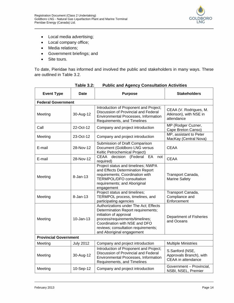
To date, Pieridae has informed and involved the public and stakeholders in many ways. These are outlined in Table 3.2.
Table 3.2: Public and Agency Consultation Activities
Event Type Date Purpose Stakeholders
Federal Government
Meeting 30-Aug-12
Introduction of Proponent and Project; Discussion of Provincial and Federal Environmental Processes, Information Requirements, and Timelines
CEAA (V. Rodrigues, M. Atkinson), with NSE in attendance
Call 22-Oct-12 Company and project introduction MP (Rodger Cuzner, Cape Breton Canso)
Meeting 23-Oct-12 Company and project introduction MP, assistant to Peter MacKay (Central Nova)
E-mail 28-Nov-12 Submission of Draft Comparison Document (Goldboro LNG versus Keltic Petrochemical Project)
CEAA
E-mail 28-Nov-12 CEAA decision (Federal EA not required) CEAA
Meeting 8-Jan-13
Project status and timelines; NWPA and Effects Determination Report requirements; Coordination with TERMPOL/DFO consultation requirements; and Aboriginal engagement
Transport Canada, Marine Safety
Meeting 8-Jan-13 Project status and timelines; TERMPOL process, timelines, and participating agencies
Transport Canada, Compliance and Enforcement
Meeting 10-Jan-13
Authorizations under The Act; Effects Determination Report requirements; initiation of approval process/requirements/timelines; Coordination with NSE and DFO reviews; consultation requirements; and Aboriginal engagement
Department of Fisheries and Oceans
Provincial Government Meeting July 2012 Company and project introduction Multiple Ministries
Meeting 30-Aug-12
Introduction of Proponent and Project; Discussion of Provincial and Federal Environmental Processes, Information Requirements, and Timelines
S.Sanford (NSE, Approvals Branch), with CEAA in attendance
Meeting 10-Sep-12 Company and project introduction Government – Provincial, NSBI, NSEL, Premier
Registration Document (Class 2 Undertaking) Goldboro LNG - Natural Gas Liquefaction Plant and Marine Terminal Pieridae Energy (Canada) Ltd.
February 2013 Page 15
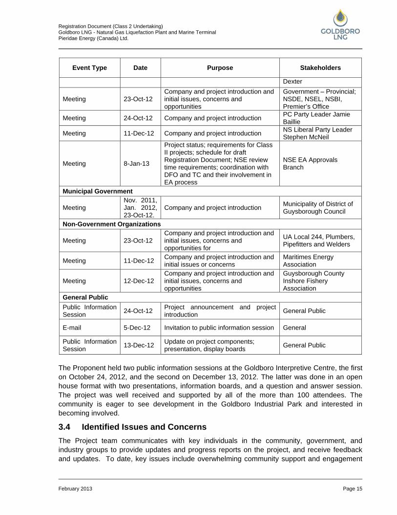
Event Type Date Purpose Stakeholders
Dexter
Meeting 23-Oct-12 Company and project introduction and initial issues, concerns and opportunities
Government – Provincial; NSDE, NSEL, NSBI, Premier’s Office
Meeting 24-Oct-12 Company and project introduction PC Party Leader Jamie Baillie
Meeting 11-Dec-12 Company and project introduction NS Liberal Party Leader Stephen McNeil
Meeting 8-Jan-13
Project status; requirements for Class II projects; schedule for draft Registration Document; NSE review time requirements; coordination with DFO and TC and their involvement in EA process
NSE EA Approvals Branch
Municipal Government
Meeting Nov. 2011, Jan. 2012, 23-Oct-12.
Company and project introduction Municipality of District of Guysborough Council
Non-Government Organizations
Meeting 23-Oct-12 Company and project introduction and initial issues, concerns and opportunities for
UA Local 244, Plumbers, Pipefitters and Welders
Meeting 11-Dec-12 Company and project introduction and initial issues or concerns
Maritimes Energy Association
Meeting 12-Dec-12 Company and project introduction and initial issues, concerns and opportunities
Guysborough County Inshore Fishery Association
General Public Public Information Session 24-Oct-12 Project announcement and project
introduction General Public
E-mail 5-Dec-12 Invitation to public information session General
Public Information Session 13-Dec-12 Update on project components;
presentation, display boards General Public
The Proponent held two public information sessions at the Goldboro Interpretive Centre, the first on October 24, 2012, and the second on December 13, 2012. The latter was done in an open house format with two presentations, information boards, and a question and answer session. The project was well received and supported by all of the more than 100 attendees. The community is eager to see development in the Goldboro Industrial Park and interested in becoming involved.
3.4 Identified Issues and Concerns The Project team communicates with key individuals in the community, government, and industry groups to provide updates and progress reports on the project, and receive feedback and updates. To date, key issues include overwhelming community support and engagement
Registration Document (Class 2 Undertaking) Goldboro LNG - Natural Gas Liquefaction Plant and Marine Terminal Pieridae Energy (Canada) Ltd.
February 2013 Page 16
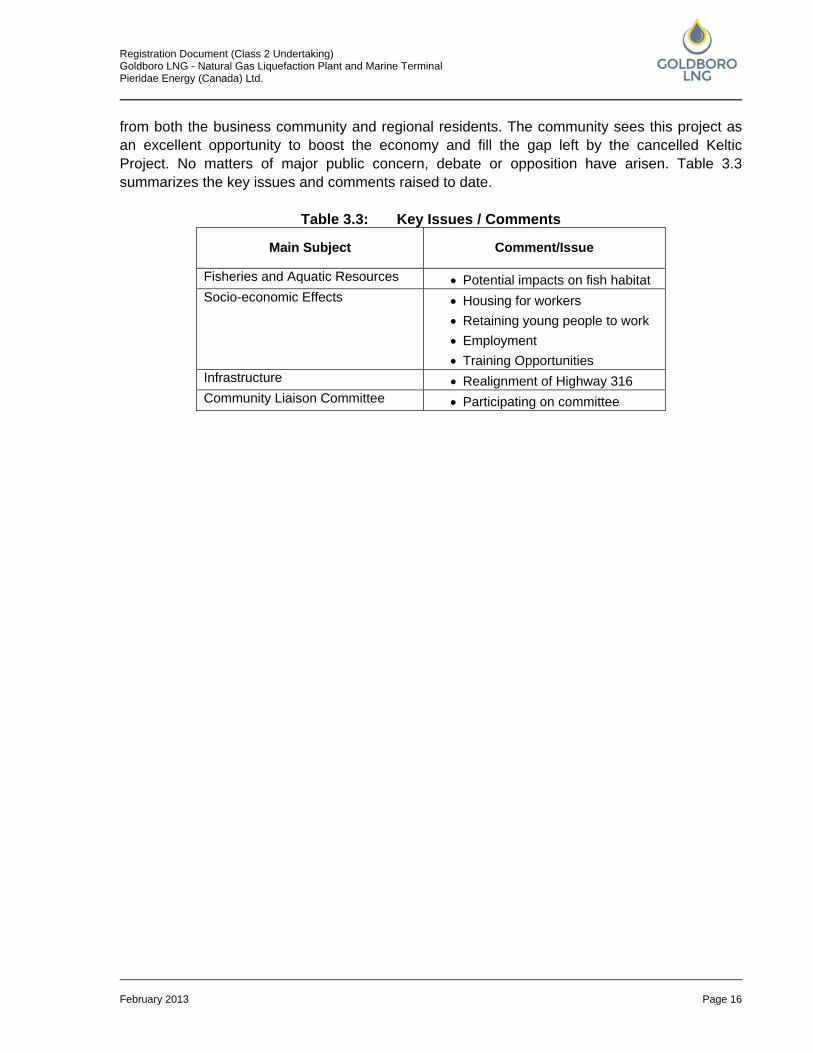
from both the business community and regional residents. The community sees this project as an excellent opportunity to boost the economy and fill the gap left by the cancelled Keltic Project. No matters of major public concern, debate or opposition have arisen. Table 3.3 summarizes the key issues and comments raised to date.
Table 3.3: Key Issues / Comments
Main Subject Comment/Issue
Fisheries and Aquatic Resources • Potential impacts on fish habitat Socio-economic Effects
• Housing for workers • Retaining young people to work • Employment • Training Opportunities
Infrastructure • Realignment of Highway 316 Community Liaison Committee • Participating on committee
Registration Document (Class 2 Undertaking) Goldboro LNG - Natural Gas Liquefaction Plant and Marine Terminal Pieridae Energy (Canada) Ltd.
February 2013 Page 17
4.0 ENGAGEMENT OF ABORIGINAL COMMUNITIES 4.1 Strategy and Objectives Pieridae is cognizant that there are several international, national, and provincial processes that are enhancing the role and relationship between governments and aboriginal communities in Nova Scotia. As required in the Nova Scotia Environmental Assessment Regulations, Pieridae will outline all steps taken to identify the concerns of Aboriginal people about the potential adverse effects or the environmental effects of the Project. Pieridae has taken direction from both “A Proponent’s Guide to Environmental Assessment,” September 2009, and “Proponent’s Guide: Engagement with Mi’kmaq of Nova Scotia,” May 2009, in developing its strategies and objectives. To this end, Pieridae sees early engagement with the Aboriginal community in Nova Scotia as a priority and has developed an Aboriginal Community Engagement Strategy. The premise of the engagement strategy is that, through effective engagement, the Proponent can establish an effective relationship with Aboriginal communities and organizations. Pieridaes’ objectives were to:
• inform Aboriginal communities about its proposal; • solicit information on the Aboriginal issues and concerns with respect to the proposed
project; and • identify ways and means for Aboriginal engagement in the planning process and
approaches to a mutually beneficial project implementation.
4.2 Aboriginal Communities and Stakeholders Based upon a preliminary assessment of the project location and involvement of Aboriginal communities in Nova Scotia, several communities and Aboriginal organizations were identified as potentially affected and/or having a direct interest in the Goldboro LNG Project. These communities and organizations are listed in Table 4.1.
Table 4.1: Key Aboriginal Communities Category Communities/Organizations
Aboriginal communities Paq’tnkek First Nation Millbrook Band Shubenacadie Band
Aboriginal organizations Assembly of Nova Scotia Mi’kmaq Chiefs Kwilmu'kw Maw-klusuaqn (KMK) Confederacy of Mainland Mi’kmaq (CMM) Union of Nova Scotia Indians (UNSI) Unama’ki Economic Benefits Office Native Council of Nova Scotia
Provincial organizations Nova Scotia Office of Aboriginal Affairs
Registration Document (Class 2 Undertaking) Goldboro LNG - Natural Gas Liquefaction Plant and Marine Terminal Pieridae Energy (Canada) Ltd.
February 2013 Page 18
4.3 Engagement Activities The Aboriginal Community Engagement Strategy for the Goldboro LNG Project involves a series of engagement activities that include:
• face to face contacts with Chiefs; • presentations/meetings with communities; • presentation at regional Tribal Council/Provincial Tribal Organization meetings; • letters of notification of EA; • MEK Study; and • provision of draft EA report for review and comment.
The engagement activities that have taken place to date are listed in Table 4.2.
Table 4.2: Engagement Activities Aboriginal Community Engagement Activities Date Face to face contacts with Chiefs Paq’tnkek Millbrook Indian Brook
Oct. 23, 2012 Oct. 22, 2012 Dec 12, 2012
Presentations / meetings with communities Paq’tnkek Indian Brook Mill Brook
Dec. 12, 2012 Jan. 14, 2013
Planned for Feb. 12, 2013 Presentation at regional Tribal Council/Provincial Tribal Organization meetings KMK (at AMEC) KMK Benefits Committee
Oct. 12, 2012 Nov. 16, 2012
4.4 Identified Issues and Concerns Preliminary meetings with the KMK Benefits Committee, Paq’tnkek Band Council, and individual Chiefs have been held (Table 4.2). Discussion points during these initial contacts are listed in Table 4.3. There is a general understanding between the Proponent and Aboriginal communities that the engagement process will facilitate open dialogue on matters related to First Nations interest regarding environment and economic development.
Table 4.3: Key Comments and Concerns Raised by Aboriginal Communities Subject Area Comments/Concerns/Suggestions
Opportunities (Economics, Training, Other)
Opportunities for engagement Potential for collaboration and employment Potential for training and skills development
Planning Process MEK Study Consultation and Engagement Crown role and activities regarding consultation with
Aboriginal communities about the Project Distinction between Crown Consultation and Proponent Engagement
Registration Document (Class 2 Undertaking) Goldboro LNG - Natural Gas Liquefaction Plant and Marine Terminal Pieridae Energy (Canada) Ltd.
February 2013 Page 19
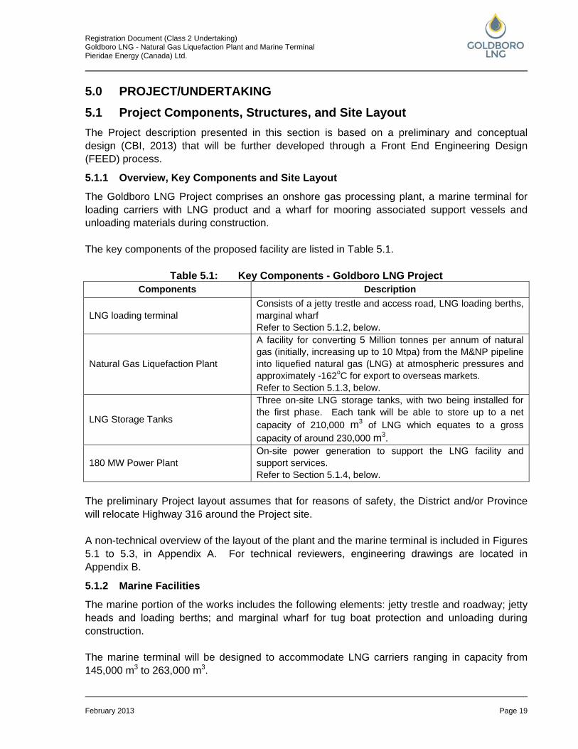
5.0 PROJECT/UNDERTAKING 5.1 Project Components, Structures, and Site Layout The Project description presented in this section is based on a preliminary and conceptual design (CBI, 2013) that will be further developed through a Front End Engineering Design (FEED) process.
5.1.1 Overview, Key Components and Site Layout
The Goldboro LNG Project comprises an onshore gas processing plant, a marine terminal for loading carriers with LNG product and a wharf for mooring associated support vessels and unloading materials during construction. The key components of the proposed facility are listed in Table 5.1.
Table 5.1: Key Components - Goldboro LNG Project Components Description
LNG loading terminal Consists of a jetty trestle and access road, LNG loading berths, marginal wharf Refer to Section 5.1.2, below.
Natural Gas Liquefaction Plant
A facility for converting 5 Million tonnes per annum of natural gas (initially, increasing up to 10 Mtpa) from the M&NP pipeline into liquefied natural gas (LNG) at atmospheric pressures and approximately -162oC for export to overseas markets. Refer to Section 5.1.3, below.
LNG Storage Tanks
Three on-site LNG storage tanks, with two being installed for the first phase. Each tank will be able to store up to a net capacity of 210,000 m3 of LNG which equates to a gross capacity of around 230,000 m3.
180 MW Power Plant On-site power generation to support the LNG facility and support services. Refer to Section 5.1.4, below.
The preliminary Project layout assumes that for reasons of safety, the District and/or Province will relocate Highway 316 around the Project site. A non-technical overview of the layout of the plant and the marine terminal is included in Figures 5.1 to 5.3, in Appendix A. For technical reviewers, engineering drawings are located in Appendix B.
5.1.2 Marine Facilities
The marine portion of the works includes the following elements: jetty trestle and roadway; jetty heads and loading berths; and marginal wharf for tug boat protection and unloading during construction. The marine terminal will be designed to accommodate LNG carriers ranging in capacity from 145,000 m3 to 263,000 m3.
Registration Document (Class 2 Undertaking) Goldboro LNG - Natural Gas Liquefaction Plant and Marine Terminal Pieridae Energy (Canada) Ltd.
February 2013 Page 20
The layout of the marine terminal has been arranged so as to avoid the need for dredging whilst retaining access into the channel leading to Isaac’s and Country Harbours. The proposed layout of the marine facilities is included in Figure 5.3. A technical drawing which includes the vessel turning radius is included in Appendix B (Overall Plot Plan – Jetty & Berthing). Marine studies are on-going, however, and the final alignment and length of the jetty is subject to their completion.
5.1.2.1 LNG Jetty Trestle, Transfer Lines and Access Road
The jetty trestle will accommodate piping, cabling, and the access road between the main plant and the loading berths. The trestle will be approximately 6m wide and will include loop structures approximately every 200 m along its length; although loop spacing must be finalized in FEED once detailed piping and surge analysis is completed. A 5 m wide access road will also be carried by the common supporting structure. A preliminary drawing with some detail of the proposed jetty structure is provided in Appendix B (LNG Jetty – Approach Trestle Details). The trestle will be a steel truss structure and will be mounted on 3.5 m diameter monopiles sunk into the sea bed. Monopiles have been selected at this stage with the objective of minimizing the marine piling as far as practicable, and to minimize potential ice loads on the structure. The jetty will also include a maintenance access road leading to the jetty heads that will be supported on the same piles as the trestle. At this stage of the project it has been assumed that the piles will be spaced at 45 m intervals along the jetty length. This will need to be confirmed in the FEED phase once detailed structural design is completed. The jetty trestle will be designed to accommodate the piping for phase 1 (5 Million tonnes per annum) and phase 2 (10 Mtpa) of the project in order to minimize nearshore work in the expansion phase, and has been routed so as to avoid the sensitive Red Head area. The piping will carry LNG liquid and boil off gas, utilities such as air, nitrogen and water and possibly diesel for refuelling of tug boats. The need for the latter will be determined in the FEED phase of the project.
5.1.2.2 LNG Jetty Head and Loading Berths
The project will eventually encompass a total of two LNG loading berths located on a common jetty head. Although only one berth will be developed in the first phase, disruptive work such as piling will be completed for both berths in phase one. The piping design has been developed to take account for maximum plant throughput of 10 Mtpa. The jetty head will comprise a concrete deck structure and structural steel loading platform. The whole structure will be mounted on monopiles. The concrete sub-structure will be designed to be trafficable for maintenance access and to support jetty equipment. Normally rainwater is not collected on jetty heads unless there are heavy hydrocarbons present. Further work will be required in FEED to determine the drainage philosophy on the marine structure. The jetty head area will also include berthing and mooring dolphins used to fix the LNG carriers in position during loading. Each of the dolphins will comprise a monopile and concrete deck structure.
Registration Document (Class 2 Undertaking) Goldboro LNG - Natural Gas Liquefaction Plant and Marine Terminal Pieridae Energy (Canada) Ltd.
February 2013 Page 21
Each loading berth will contain four LNG loading arms, that carry LNG and LNG vapour between the carrier and the LNG storage facility, the intent being to minimise any emissions (i.e., vapour is captured as opposed to being vented as it would normally be on a condensate vessel, for example). The LNG carriers will be loaded with LNG at a rate of 12,000 m3/h using three of the loading arms attached to the carrier. The remaining loading arm will be used to transfer displaced vapour back to the plant. The basis of the marine terminal design is that only one berth will actually be loading at a time in phase 2, although a second carrier can be maneuvered in preparation for loading. The carriers are maneuvered to and from the jetty berths by tug boats in order to ensure the loading operation is completed safely. It typically takes up to 24 hours to load a vessel depending on the size of the carrier. Initial assessments indicate that the approach to the berths from offshore requires the vessels to take a route over the Sable and Deep Panuke pipelines, as was found to be the case for the MapleLNG project (MapleLNG, 2008). Final jetty layout, turning circles, and approach requirements will be confirmed in further studies in FEED. Further work is required in FEED to establish wave conditions, bathymetry, and the location of a nearby shipwreck to confirm suitability of the proposed marine layout. In addition, a detailed study will be required to determine the need for ice breaking capability and/or equipment for the tug boats or the jetty.
5.1.2.3 Marginal Wharf and Causeway
A marginal wharf and causeway of combined length totaling 480 m will be constructed parallel to the jetty approach trestle and on the southerly end of Red Head, that will initially accommodate barges and cargo vessels for the transfer of modules used in the construction of the LNG plant and associated infrastructure. Following the construction phase of the LNG plant, the marginal wharf will be used to accommodate tug, line, and pilot boats. The marginal wharf is envisaged to be 220 m in length and 44 m wide in order to allow the safe unloading of modules weighing up to 1000 tonnes. The marginal wharf proposed for the Goldboro LNG Project represents a significant reduction on that proposed for the Keltic Project and MapleLNG Project. The marginal wharf location has been selected to permit sufficient draught for the vessels used in transporting and unloading modules in the construction phase. The wharf quay will be constructed from combi-walls which comprise large diameter steel piles with sheet piles between them to form the perimeter, on top of which is mounted a concrete cope. Following completion of the combi-walls, the wharf is then filled with suitable (clean) material and topped with an asphalt layer.
Registration Document (Class 2 Undertaking) Goldboro LNG - Natural Gas Liquefaction Plant and Marine Terminal Pieridae Energy (Canada) Ltd.
February 2013 Page 22
To allow passage of modules to the onshore plant area, a 260 m long causeway will be constructed to join the marginal wharf to the land. The causeway will connect to the south eastern end of Red Head to utilize the easement leading to the LNG plant. The causeway will be a composite structure comprising revetments and asphalt topped suitable fill material. The revetments are constructed by suitable fill material protected by concrete and rock armoury all placed upon a geotextile membrane Power and utilities will also be required on the quay. This will be supplied by a link between the marginal wharf and the main jetty trestle. Diesel may also be required if the tug boats are refuelled at the wharf. Further work must be completed in FEED to confirm the construction methodology and the need for refuelling facilities for the tug and pilot boats.
5.1.2.4 Jetty Buildings
The jetty will also include a building for housing the electrical power and control panels for the equipment mounted on the jetty. Further work must be undertaken to confirm that one building is sufficient for both phases of the project. An additional building will be required to house the sea water pumps which (with the exception of a 1 hour weekly test) will be used only as a backup in the event of a significant fire and when the fresh fire water has been exhausted.
5.1.3 LNG Liquefaction Plant
The Goldboro LNG onshore facility will comprise the following major components:
• inlet facilities and feed gas compression; • gas treatment facilities; • natural gas liquefaction train; • near Atmospheric LNG storage and boil off gas compression; • refrigerant storage; • on-plot power generation; • flare stacks; • raw water extraction and storage; • plant utilities; • waste water and storm water management; • administration and control buildings; and • truck loading facility.
The LNG plant is summarized in a block diagram in Appendix B (Overall Block Flow Diagram), and in plant layout as per Figure 5.2. Technical reviewers should refer to Appendix B.
Registration Document (Class 2 Undertaking) Goldboro LNG - Natural Gas Liquefaction Plant and Marine Terminal Pieridae Energy (Canada) Ltd.
February 2013 Page 23
5.1.3.1 Process Facilities
Inlet Facilities and Gas Compression It is assumed that the LNG facility will receive feed gas from the M&NP pipeline through a letdown station and a fiscal quality metering station (provided by the LNG facility). No liquids are normally expected in the feed gas, therefore no slug catching facilities have been provided. However, there is the requirement for feed gas compression given the assumed plant inlet pressure of 43 Barg (Bar gauge) as it is required to operate the liquefaction unit in the range of 60 to 70 Barg. Since feed gas compression will be installed, compressor protection from liquids will be achieved by compressor suction knock out drums. The compressors will be electric motor driven. The inlet area may also include a pig trap to allow inspection of the pipeline by intelligent pigs. This is to be confirmed in FEED. Gas Treatment Facilities In order to ensure the inlet gas is suitable for liquefaction, trace contaminants must be removed in the gas treatment facilities. Contaminants include mercury, water, heavy hydrocarbons, and carbon dioxide. Mercury removal beds filled with activated carbon adsorbent will be utilized. The exhausted adsorbent will need to be removed and treated by specialists to enable recovery of the mercury. It is necessary to remove CO2 from the feed gas to prevent freezing in the cryogenic sections of the plant. CO2 is present in the feed gas in concentrations of up to 2.1 mol% and requires removal to a concentration of 50 ppmv (parts per million (volumetric)). The design concentration of CO2 will be 3 mol%. H2S is also present in the feed gas and will require the removal of a few ppmv to meet the LNG specification. The technology selected for acid gas removal uses amine based chemical absorption thus necessitating storage of amines onsite. The amine storage tanks will include a blanketing system to prevent emissions. The waste acid gas will contain predominantly CO2 and water. These will be either vented to the atmosphere or incinerated depending on the final composition of the acid gas. Molecular sieves will then used to remove water from the gas stream to prevent it freezing in the liquefaction train. The molecular sieve comprises a crystalline alkali metal adsorbent and results in a residual waste water stream that will be further treated prior to discharge to the sea. Traces of heavy hydrocarbons will also need to be removed. The process for achieving this will be determined in the FEED phase once final inlet gas compositions are confirmed. Depending on the nature and quantities of natural gas liquids produced, the resultant stream will be either stored for later transportation to market or disposed of by incineration. Natural Gas Liquefaction Train The liquefaction technology selected as the basis for the conceptual work is the propane pre-cooled mixed refrigerant process (C3MR). This process uses two main refrigerant cycles. The
Registration Document (Class 2 Undertaking) Goldboro LNG - Natural Gas Liquefaction Plant and Marine Terminal Pieridae Energy (Canada) Ltd.
February 2013 Page 24
first is a single component refrigerant cycle using propane to achieve pre-cooling of the natural gas and mixed refrigerant (MR). The second is an MR cycle which liquefies and sub-cools the feed gas. The MR is composed of nitrogen, methane, ethane (and/or ethylene), and propane. It is envisaged that the total 10 Mtpa LNG producing capability will be installed in two phases, one train per phase. Each of the two trains will produce approximately 5 Mtpa of liquid natural gas at a temperature of around -162oC. The key elements of the liquefaction trains are the refrigerant compressors which will utilize gas turbine drivers of approximately 160MW per train. The LNG technology selected as the basis for the conceptual work is proven and has been used in over 70% of the existing LNG production facilities. A schematic summarizing the liquefaction process is shown in Appendix B (Generic Liquefaction Schematic). Near Atmospheric LNG Storage and Boil Off Gas Compression Once the gas is liquefied it will be stored in full containment storage tanks at near atmospheric pressure. This technology represents the best available for the service. A total of three tanks will be required for the 10 Mtpa plant, with two being installed for the first phase. Each tank will be able to store up to a net capacity of 210,000 m3 of LNG which equates to a gross capacity of around 230,000 m3. The final sizing of the tanks will depend on the results of FEED, although they will be no larger than described here. Full-containment tanks typically feature a primary liquid containment open-top inner tank and a steel or concrete outer tank. The outer tank provides primary vapor containment and secondary liquid containment. In the unlikely event of a leak, the outer tank contains the liquid and provides controlled release of the vapor via tank pressure relief valves. The tanks are designed and constructed to retain natural gas in liquid and gaseous form in the unlikely event of a leak of the inner tank. Any vapours, or boil off gas (BOG), that are generated within the storage tanks are captured and compressed for use as fuel gas by the power plant. A foundation heating system may also be used depending on the foundation selected in the next phase of the project. Submerged motor cryogenic pumps used to send the LNG product to the jetty heads will be installed within the tanks. These typically operate below 10 Barg and will pump a total of 12,000m3/h of LNG to the carriers. A smaller submerged motor pump may also be installed in at least one of the tanks to circulate LNG around the loading system to keep it cool and to prevent gas building up. The BOG compressors will be installed in a building to protect them from the environment and to provide some attenuation of noise generated.
Registration Document (Class 2 Undertaking) Goldboro LNG - Natural Gas Liquefaction Plant and Marine Terminal Pieridae Energy (Canada) Ltd.
February 2013 Page 25
5.1.3.2 Utilities, Infrastructure, and Support Systems
Refrigerant Storage Hydrocarbons used in the refrigeration process of the LNG liquefaction trains will need to be stored onsite for make-up purposes. The refrigerant bullets will also be sized to contain the inventory of the system temporarily in the event of maintenance. The bullets will be of the pressurized containment type; although this will need to be confirmed during the next phase of the project subject to a quantitative risk assessment. The bullets will be installed in a mounded area. Flare Stacks Three flares will be included in the plant design. They are:
• a warm/wet high pressure flare; • a cold/dry high pressure flare; and • a cold/dry low pressure flare.
The high pressure flares will be elevated pilot lit flares located on a common derrick. The flare stacks are demountable and the flare stack height is estimated to be approximately 120-180 m above ground level. A common high pressure spare flare stack will be included in the common derrick. A single, low pressure, cold/dry storage and loading flare will be constructed. This flare will be located in an area adjacent to the LNG tanks and will be approximately 30 to 40 m high. LNG Truck Loading Facility Space has been reserved on the plot for the possible addition of a small LNG truck loading terminal in order to serve the local community. A total of up to four LNG truck loading bays are envisaged. The truck loading facility would be separated from the main plant with a dedicated entrance and security. Pipeline Tie-in A short pipeline will be required to tie-in to the existing M&NP pipeline. It is proposed that the pipeline follows the route of the installed Sable and Deep Panuke pipe corridor entering the Goldboro LNG site through the north eastern boundary directly into the Goldboro LNG inlet facilities area. The preliminary design has an approximate pipeline length of 2.5 km; however, in the FEED it may be possible to reduce the length depending on a number of technical factors. Red Head Access Road A road will need to be constructed on the Red Head easement in order to move the LNG plant modules from the marginal wharf to the main plant area. Modules will weigh up to 1000 tonnes and will require a road of width in the order of 44 m. Some allowance will also be required to build the road up to the correct elevation. The final width will be dependent on the stability of the material used to construct. This will be determined using detailed geotechnical surveys to be completed in the next phase of work.
Registration Document (Class 2 Undertaking) Goldboro LNG - Natural Gas Liquefaction Plant and Marine Terminal Pieridae Energy (Canada) Ltd.
February 2013 Page 26
In addition to the facilities mentioned above, the following will be required for the safe operation of the LNG plant and marine terminal:
• Programmable logic controller based control system; • fire and gas system; • emergency shutdown system – including possible links to the nearby Sable Plant; • security systems and closed circuit television; • control building; • substations; • field auxiliary rooms; • fire station; • fire pump buildings; • warehouses and storage buildings; • rotating equipment shelters; • construction work camp; • air and nitrogen generation plant; and • additional infrastructure as may be required to support safe operation of the facility.
5.1.3.3 Plant Water Supply
The facility will be predominantly air cooled and as such will not require large volumes of raw, fresh water as had been proposed for the Keltic Project. Any need for water cooling of equipment will utilize closed system packages dedicated for the purpose. The main users of fresh water for the Goldboro LNG Project are the firewater system, service water, and potable water. It is estimated that a base water demand of 15 to 20 m3/h is required with a peak demand of around 30 m3/h. It is envisaged that the water will be sourced locally from wells although this is subject to further study and confirmation in the FEED stage. To cover the peak demand rates, water will be stored in dual service firewater/service water tanks; the final size of the tanks is to be determined in FEED. A back-up fire water supply will be provided via sea water pumps installed on the jetty. These will only be used in the event of the fresh water supply being depleted, but will be operated during routine statutory testing, which typically takes place for 1 hour per week.
5.1.3.4 Solid Waste, Air, Noise and Water Emissions
Solid Waste and Air and Noise Emissions The Goldboro LNG project will generate the following during construction and operations:
• Emissions to air, arising from combustion processes as well as venting from equipment. Combustion emission products will include CO2, CO, nitrogen oxides (NOx), Sulphur Oxides (SOx), unburnt volatile organic compounds (VOCs) and particulate matter (PM). Vented emissions will include nitrogen and fugitive VOCs;
• Noise and vibration, notably from rotating equipment and percussive activities (piling); • Solid and drummed waste arising from construction, operations, maintenance and
domestic activities, including:
Registration Document (Class 2 Undertaking) Goldboro LNG - Natural Gas Liquefaction Plant and Marine Terminal Pieridae Energy (Canada) Ltd.
February 2013 Page 27
• hazardous wastes arising from use of paints, oils, batteries etc.; • sanitary and medical waste; • oily waste; • radioactive waste (spent sources from testing activities); • inert construction waste, including soil and rock; • contaminated soil and rock from historic mining contaminated soils, acid generating
bedrock or small accidental spills during construction; and • exhausted catalysts and adsorbents.
Waste Water Management The plant will have a waste water treatment facility used to treat and discharge plant water into the sea at the south eastern corner of the plot. The final location of the discharge point will be selected in FEED subject to dispersion analysis and to meeting any environmental requirements. The water management systems will comprise a number of streams including; potentially contaminated, oily water, and domestic water. Stormwater will be treated as either clean when it originates in clean plant areas, or potentially contaminated when from process areas. Water from process areas may be further segregated into first flush that will be monitored for contamination before either treatment or discharge to sea. Runoff from uncontaminated areas will not be treated prior to discharge although monitoring may be required. All water to be discharged to the sea will be routed via sedimentation ponds to ensure no sediment is discharged. Normal domestic sanitary waste will be partially treated on site prior to removal by vacuum truck for local treatment off-site. Further study is required in FEED to confirm this philosophy.
5.1.4 Power Plant
The facility will require up to 180 MW of electrical power for the 10 Mtpa plant. The final power requirement will be dependent on the final process configuration and feed gas composition, both to be finalized in the next phase of the project. Power will be supplied by industrial gas turbines driven generator sets in an open cycle configuration. Emergency back-up power supply will also be required to ensure the safe start-up and/or operation of the plant in the event of a failure of the normal supply. The emergency power supply will be a diesel driven genset coupled with UPS (batteries) for the essential power loads.
5.1.5 Route 316 Realignment
For reasons of safety it is proposed that highway 316 is relocated. The current routing of the road would take it in close proximity to the refrigerant bullets, the LNG storage tanks, the BOG compressors and the LP flare. The preliminary Project layout assumes that the District and/or Province will re-align Highway 316 around the Project site.
Registration Document (Class 2 Undertaking) Goldboro LNG - Natural Gas Liquefaction Plant and Marine Terminal Pieridae Energy (Canada) Ltd.
February 2013 Page 28
5.1.6 Watercourse Diversions
The unnamed small watercourse that runs along the western boundary and leads into Dung Cove Pond on Red Head will need to be diverted around the perimeter of the site.
5.2 Project Activities 5.2.1 Construction Phase
The construction period of the main plant area and marine facilities, including cargo offloading facility, will span approximately 48 months. The plant site will provide rock suitable for concrete and foundation backfill and will therefore become the principal source of such needs at the site and marine facilities. This will involve some blasting, heavy excavation equipment, crushing and screening. A concrete batching plant will be established for the construction period. After site preparation, the activities will shift to installation of foundations and heavy haul roads linking the marine offloading facility (MOF) with the site. Construction of the MOF will proceed simultaneously with the land-based Project components. This facility will be able to accommodate ocean going barges and self propelled project cargo ships and module carriers. Prefabrication activities will proceed off site in parallel with civil works, so that, as foundations are completed, phased delivery of prefabricated structures, equipment skids, subassemblies, and modules can progress. Deliveries will be sequenced to support the installation, hook-up, and commissioning program. Modules, and heavy vessels and equipment will be delivered from the MOF direct to foundations, to the extent practicable, using self propelled modular trailers (SPMTs) to minimize the double handling of heavy items and the associated safety risks. Construction will be work packaged from the outset so that the integrity of modules, subassemblies and skids can be better managed. Construction sequencing will be strongly focused on the testing and commissioning program that brings the plant in to operation on schedule. Construction of the LNG tanks will be performed under a turnkey subcontract by an LNG tank engineering, procurement, and construction (EPC) specialist company. This will be done in parallel with plant and utilities construction. No dredging is anticipated in the construction of the marine facilities. The marginal wharf and causeway area will be formed by backfilling rock excavated from the project area. The LNG berthing docks will be of piled construction. Appropriate dust and drainage control based on the avoidance of environmentally sensitive areas will be applied throughout.
5.2.2 Operational Phase
Refer to sections 5.1 and 5.3 for operation phase activities and their environmental impacts.
5.2.3 Decommissioning Phase
The general approach to decommissioning of the facility will be developed as part of the environmental assessment process.
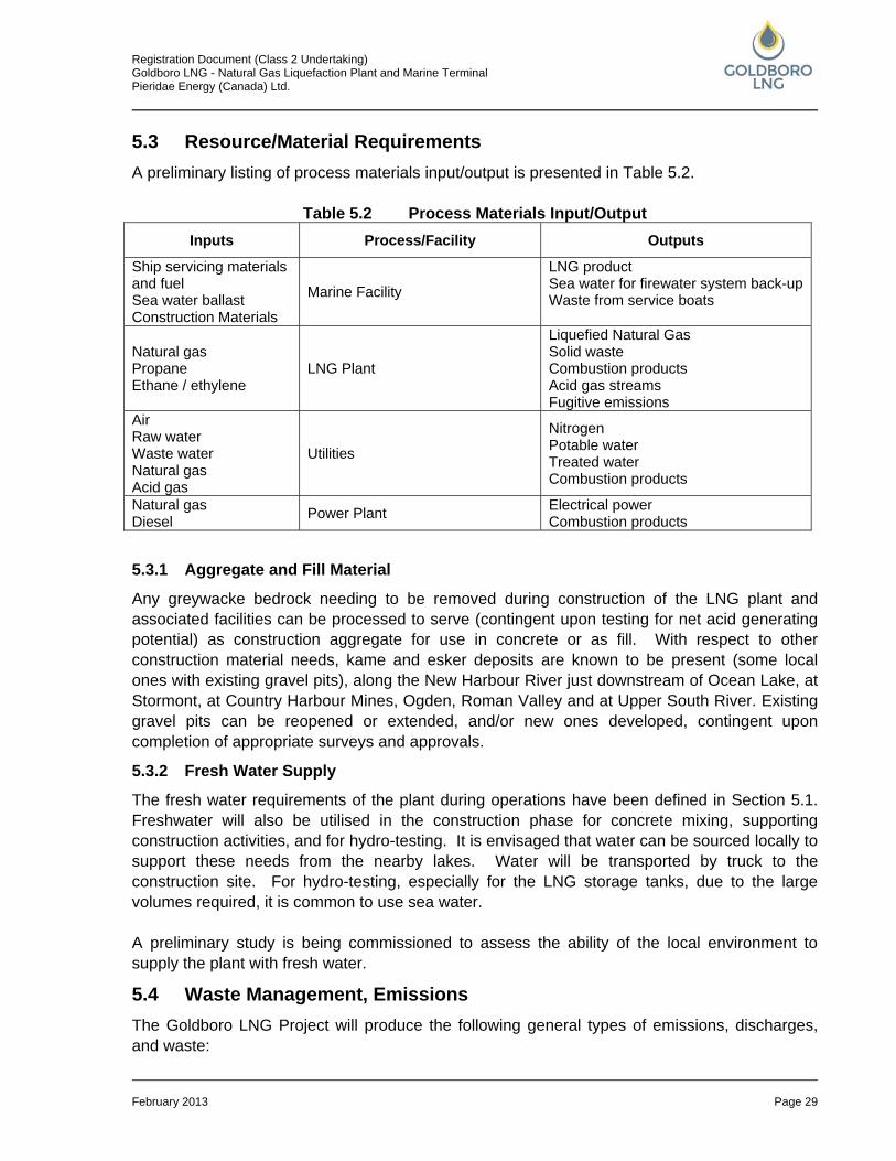
Registration Document (Class 2 Undertaking) Goldboro LNG - Natural Gas Liquefaction Plant and Marine Terminal Pieridae Energy (Canada) Ltd.
February 2013 Page 29
5.3 Resource/Material Requirements A preliminary listing of process materials input/output is presented in Table 5.2.
Table 5.2 Process Materials Input/Output Inputs Process/Facility Outputs
Ship servicing materials and fuel Sea water ballast Construction Materials
Marine Facility
LNG product Sea water for firewater system back-up Waste from service boats
Natural gas Propane Ethane / ethylene
LNG Plant
Liquefied Natural Gas Solid waste Combustion products Acid gas streams Fugitive emissions
Air Raw water Waste water Natural gas Acid gas
Utilities
Nitrogen Potable water Treated water Combustion products
Natural gas Diesel Power Plant Electrical power
Combustion products
5.3.1 Aggregate and Fill Material
Any greywacke bedrock needing to be removed during construction of the LNG plant and associated facilities can be processed to serve (contingent upon testing for net acid generating potential) as construction aggregate for use in concrete or as fill. With respect to other construction material needs, kame and esker deposits are known to be present (some local ones with existing gravel pits), along the New Harbour River just downstream of Ocean Lake, at Stormont, at Country Harbour Mines, Ogden, Roman Valley and at Upper South River. Existing gravel pits can be reopened or extended, and/or new ones developed, contingent upon completion of appropriate surveys and approvals.
5.3.2 Fresh Water Supply
The fresh water requirements of the plant during operations have been defined in Section 5.1. Freshwater will also be utilised in the construction phase for concrete mixing, supporting construction activities, and for hydro-testing. It is envisaged that water can be sourced locally to support these needs from the nearby lakes. Water will be transported by truck to the construction site. For hydro-testing, especially for the LNG storage tanks, due to the large volumes required, it is common to use sea water. A preliminary study is being commissioned to assess the ability of the local environment to supply the plant with fresh water.
5.4 Waste Management, Emissions The Goldboro LNG Project will produce the following general types of emissions, discharges, and waste:
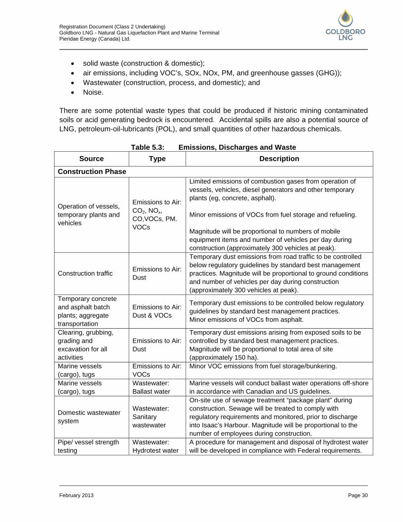
Registration Document (Class 2 Undertaking) Goldboro LNG - Natural Gas Liquefaction Plant and Marine Terminal Pieridae Energy (Canada) Ltd.
February 2013 Page 30
• solid waste (construction & domestic); • air emissions, including VOC’s, SOx, NOx, PM, and greenhouse gasses (GHG)); • Wastewater (construction, process, and domestic); and • Noise.
There are some potential waste types that could be produced if historic mining contaminated soils or acid generating bedrock is encountered. Accidental spills are also a potential source of LNG, petroleum-oil-lubricants (POL), and small quantities of other hazardous chemicals.
Table 5.3: Emissions, Discharges and Waste Source Type Description
Construction Phase
Operation of vessels, temporary plants and vehicles
Emissions to Air: CO2, NOx, CO,VOCs, PM. VOCs
Limited emissions of combustion gases from operation of vessels, vehicles, diesel generators and other temporary plants (eg, concrete, asphalt). Minor emissions of VOCs from fuel storage and refueling. Magnitude will be proportional to numbers of mobile equipment items and number of vehicles per day during construction (approximately 300 vehicles at peak).
Construction traffic Emissions to Air: Dust
Temporary dust emissions from road traffic to be controlled below regulatory guidelines by standard best management practices. Magnitude will be proportional to ground conditions and number of vehicles per day during construction (approximately 300 vehicles at peak).
Temporary concrete and asphalt batch plants; aggregate transportation
Emissions to Air: Dust & VOCs
Temporary dust emissions to be controlled below regulatory guidelines by standard best management practices. Minor emissions of VOCs from asphalt.
Clearing, grubbing, grading and excavation for all activities
Emissions to Air: Dust
Temporary dust emissions arising from exposed soils to be controlled by standard best management practices. Magnitude will be proportional to total area of site (approximately 150 ha).
Marine vessels (cargo), tugs
Emissions to Air: VOCs
Minor VOC emissions from fuel storage/bunkering.
Marine vessels (cargo), tugs
Wastewater: Ballast water
Marine vessels will conduct ballast water operations off-shore in accordance with Canadian and US guidelines.
Domestic wastewater system
Wastewater: Sanitary wastewater
On-site use of sewage treatment “package plant” during construction. Sewage will be treated to comply with regulatory requirements and monitored, prior to discharge into Isaac’s Harbour. Magnitude will be proportional to the number of employees during construction.
Pipe/ vessel strength testing
Wastewater: Hydrotest water
A procedure for management and disposal of hydrotest water will be developed in compliance with Federal requirements.
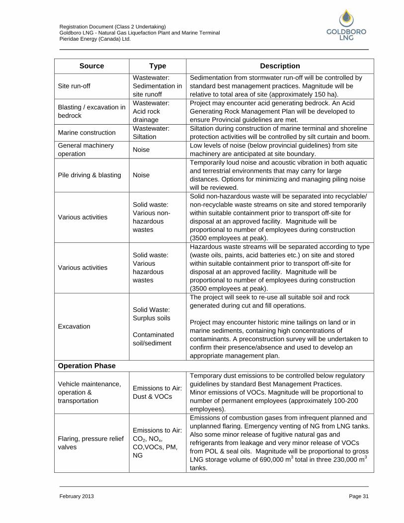
Registration Document (Class 2 Undertaking) Goldboro LNG - Natural Gas Liquefaction Plant and Marine Terminal Pieridae Energy (Canada) Ltd.
February 2013 Page 31
Source Type Description
Site run-off Wastewater: Sedimentation in site runoff
Sedimentation from stormwater run-off will be controlled by standard best management practices. Magnitude will be relative to total area of site (approximately 150 ha).
Blasting / excavation in bedrock
Wastewater: Acid rock drainage
Project may encounter acid generating bedrock. An Acid Generating Rock Management Plan will be developed to ensure Provincial guidelines are met.
Marine construction Wastewater: Siltation
Siltation during construction of marine terminal and shoreline protection activities will be controlled by silt curtain and boom.
General machinery operation Noise Low levels of noise (below provincial guidelines) from site
machinery are anticipated at site boundary.
Pile driving & blasting Noise
Temporarily loud noise and acoustic vibration in both aquatic and terrestrial environments that may carry for large distances. Options for minimizing and managing piling noise will be reviewed.
Various activities
Solid waste: Various non-hazardous wastes
Solid non-hazardous waste will be separated into recyclable/ non-recyclable waste streams on site and stored temporarily within suitable containment prior to transport off-site for disposal at an approved facility. Magnitude will be proportional to number of employees during construction (3500 employees at peak).
Various activities
Solid waste: Various hazardous wastes
Hazardous waste streams will be separated according to type (waste oils, paints, acid batteries etc.) on site and stored within suitable containment prior to transport off-site for disposal at an approved facility. Magnitude will be proportional to number of employees during construction (3500 employees at peak).
Excavation
Solid Waste: Surplus soils Contaminated soil/sediment
The project will seek to re-use all suitable soil and rock generated during cut and fill operations. Project may encounter historic mine tailings on land or in marine sediments, containing high concentrations of contaminants. A preconstruction survey will be undertaken to confirm their presence/absence and used to develop an appropriate management plan.
Operation Phase
Vehicle maintenance, operation & transportation
Emissions to Air: Dust & VOCs
Temporary dust emissions to be controlled below regulatory guidelines by standard Best Management Practices. Minor emissions of VOCs. Magnitude will be proportional to number of permanent employees (approximately 100-200 employees).
Flaring, pressure relief valves
Emissions to Air: CO2, NOx, CO,VOCs, PM, NG
Emissions of combustion gases from infrequent planned and unplanned flaring. Emergency venting of NG from LNG tanks. Also some minor release of fugitive natural gas and refrigerants from leakage and very minor release of VOCs from POL & seal oils. Magnitude will be proportional to gross LNG storage volume of 690,000 m3 total in three 230,000 m3 tanks.
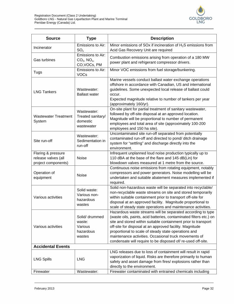
Registration Document (Class 2 Undertaking) Goldboro LNG - Natural Gas Liquefaction Plant and Marine Terminal Pieridae Energy (Canada) Ltd.
February 2013 Page 32
Source Type Description
Incinerator Emissions to Air: SOx
Minor emissions of SOx if incineration of H2S emissions from Acid Gas Recovery Unit are required
Gas turbines Emissions to Air: CO2, NOx, CO,VOCs, PM
Combustion emissions arising from operation of a 180 MW power plant and refrigerant compressor drivers.
Tugs Emissions to Air: VOCs
Minor VOC emissions from fuel storage/bunkering.
LNG Tankers Wastewater: Ballast water
Marine vessels conduct ballast water exchange operations offshore in accordance with Canadian, US and international guidelines. Some unexpected local release of ballast could occur. Expected magnitude relative to number of tankers per year (approximately 160/yr).
Wastewater Treatment System
Wastewater: Treated sanitary/ domestic wastewater
On-site plant for partial treatment of sanitary wastewater, followed by off-site disposal at an approved location. Magnitude will be proportional to number of permanent employees and total area of site (approximately 100-200 employees and 150 ha site).
Site run-off Wastewater: Sedimentation in run-off
Uncontaminated site run-off separated from potentially contaminated run-off and directed to pond/ ditch drainage system for “settling” and discharge directly into the environment.
Flaring & pressure release valves (all project components)
Noise Infrequent unplanned loud noise production typically up to 110 dBA at the base of the flare and 145 dB(Lin) for blowdown valves measured at 1 metre from the source.
Operation of equipment Noise
Continuous noise emissions from rotating equipment, notably compressors and power generators. Noise modelling will be undertaken and suitable abatement measures implemented if required.
Various activities
Solid waste: Various non-hazardous wastes
Solid non-hazardous waste will be separated into recyclable/ non-recyclable waste streams on site and stored temporarily within suitable containment prior to transport off-site for disposal at an approved facility. Magnitude proportional to scale of steady state operations and maintenance activities.
Various activities
Solid/ drummed waste: Various hazardous wastes
Hazardous waste streams will be separated according to type (waste oils, paints, acid batteries, contaminated filters etc.) on site and stored within suitable containment prior to transport off-site for disposal at an approved facility. Magnitude proportional to scale of steady state operations and maintenance activities. Occasional truck movements of condensate will require to be disposed of/ re-used off-site.
Accidental Events
LNG Spills LNG
LNG releases due to loss of containment will result in rapid vaporization of liquid. Risks are therefore primarily to human safety and asset damage from fires/ explosions rather than directly to the environment.
Firewater Wastewater: Firewater contaminated with entrained chemicals including
Registration Document (Class 2 Undertaking) Goldboro LNG - Natural Gas Liquefaction Plant and Marine Terminal Pieridae Energy (Canada) Ltd.
February 2013 Page 33
Source Type Description Firewater fire extinguishant held within retention pond to restrict
discharge to sea.
Spills (on land) POL and other hazardous chemicals
Potential for containment failure and accidental spills of minor volumes of petroleum-oil-lubricants (POL) and other hazardous chemicals. Risk to be minimized through bunding/double skinning of hazardous liquid containers, development of spill response plans and employee training.
Spills (in the marine environment)
POL and other hazardous chemicals
Potential for marine accidents to release minor volumes of POL and other hazardous chemicals to sea. Risk to be minimized through implementation of TERMPOL recommendations and development of comprehensive contingency plan. Potential risk relative to number of tankers per year (approximately 160/yr).
5.5 Malfunctions and Accidents The LNG plant and marine terminal will be designed and operated in accordance with codes and standards specifically created for LNG facilities. These codes and standards require multiple levels of safety to be put in place to ensure the safe and reliable operation of LNG facilities and reduce the risk of malfunctions to an acceptable level. Engineered equipment and systems shall be provided within the plant with the objective of:
• preventing the occurrence of hazardous events; • controlling and terminating accident events should they occur; and • protecting persons, both on and off site, from the impacts of an accident event should it
occur. The principal systems provided for this purpose are:
• fire, gas, and leak detection systems to detect and alarm of the presence of flammable vapour in air as the result of an accidental release;
• spill control systems to capture and safely contain spills and leaks of flammable liquids including cryogenic fluids;
• fixed, mobile, and portable firefighting equipment to protect personnel, equipment, and facilities in the event of a fire in the facility;
• passive fire and cryogenic spill protection systems to protect critical plant structures and equipment in the event of fires or cryogenic liquid spills;
• blast resistant buildings and structures to protect personnel and preserve critical systems in the event of a gas cloud explosion;
• clearly defined, unobstructed, and illuminated escape routes to places of safety throughout the plant covering all areas where personnel may be located during plant operation;
• elimination of potential ignition sources from all areas where flammable gas releases could occur during normal operation or as a result of accidental leaks;
Registration Document (Class 2 Undertaking) Goldboro LNG - Natural Gas Liquefaction Plant and Marine Terminal Pieridae Energy (Canada) Ltd.
February 2013 Page 34
• security systems including site access control; • oily waste water, domestic waste water and drinking water treatment facilities; • on site permanent waste handling/storage equipment; • on site permanent environmental and emissions monitoring equipment; and • plant Emissions and Discharges Register.
Engineering design reviews of temporary construction HSE (health, safety, and environment) facilities will also be performed.
5.5.1 Background Information on the Safety of LNG Trans-shipment
The LNG industry is regarded to have the best safety record of any of the energy industries. This was demonstrated by the 2008 study by Benjamin K. Sovacool, “The costs of failure: A preliminary assessment of major energy accidents, 1907–2007”, Energy Policy 36 (2008). This study showed that the LNG industry proved to be the safest in the energy industry both in terms of social and economic costs in the past century. The study analyzed 279 major incidents world-wide that have been responsible for $41 billion in property damage and 182,156 deaths. This is further supported by a number of recent studies into LNG safety undertaken for the United States Department of Energy (available at http://www.fossil.energy.gov) which includes amongst its conclusions that “Risks from accidental LNG spills, such as from collisions and groundings, are small and manageable with current safety policies and practices.”
5.6 Health, Safety & Environmental Management Creating an LNG production and export facility that can be constructed and operated safely, and with minimum impact on the environment and the wider community, is the responsibility of all the people involved in designing, constructing, and operating the plant. Good health, safety and environmental (HSE) performance and the health, safety, and security of everyone who works on the Project are critical to the success of the business. The HSE goals can be simply stated as:
• no harm to any person; • no harm to the environment; • no damage to property; • no reportable incidents; • no compromise to project security in any respect; and • improve on current best industry practice.
Registration Document (Class 2 Undertaking) Goldboro LNG - Natural Gas Liquefaction Plant and Marine Terminal Pieridae Energy (Canada) Ltd.
February 2013 Page 35
6.0 EXISTING ENVIRONMENT Information presented in this section is largely based on the previous Keltic Project EA, supplemented by a site visit in September 2012 and some limited new information (particularly for Species At Risk). The site survey has confirmed that conditions remain largely unaltered, since the Keltic Project EA. All available information sources (past and present) have been referenced accordingly. Pieridae intends to review, validate, update, and supplement all relevant data on natural and socio-economic conditions in the upcoming EA process. Figures 6.1 to 6.9, referred to in this section are located in Appendix A.
6.1 Regional Setting 6.1.1 Physiography & Geology
The Project is located within the Southern Upland physiographic region. The topography in this region is somewhat varied, with low ridges and intervening hollows that are swampy flats. The soil is generally thin and acidic. Drainage is poor because of deposits of glacial drift. Peat bogs are common, and in some areas there are wide level expanses of heath and meadow. Chains of lakes, streams, and still-water occur. River channels are shallow. The area is mainly forest country. The terrain in the Project area is generally inclined in southerly and westerly direction towards the ocean. Topography is characterized by two low ridges that run in roughly east to west direction, elevation 50 to 65 m (AMEC, 2006). The mineral soil consists generally of quartzite till and/or stony till plain deposits in Guysborough County. It is generally thin (less than 10 m), and rapid draining. Soils on the Red Head peninsula are characterized by poor drainage and are derived from quartzite glacial till parent material. All soils in this area are unsuited for agriculture (AMEC, 2006). Bedrock geology at the Project site is uniformly Goldenville Formation, containing alternating layers of sandstone and finer grained beds. Due to the large displacements that have occurred along the nearby regional faults, the structural geology within the proposed boundaries of the Project site is expected to be complex. Smaller bands of Halifax Formation or similar material may be present which have not been previously mapped. The Halifax Formation is known for its acid generating potential, and so acid drainage may be a cause for concern should this material need to be excavated, or the groundwater level lowered within the formation during plant construction. Certain rocks of the Goldenville Formation may also be a source of acid drainage, particularly (in small areas) where highly mineralized zones are present (AMEC, 2006). Borehole logs documented during the Keltic Project EA indicate that much of the Project site is underlain by bedrock consisting of greywacke with some occurrences of argillite. Argillite with pyrite and arsenopyrite was identified at the extreme northern end of the Keltic Project site where it overlapped the Halifax Formation (AMEC, 2006). This area is outside the Goldboro LNG Project boundary.
Registration Document (Class 2 Undertaking) Goldboro LNG - Natural Gas Liquefaction Plant and Marine Terminal Pieridae Energy (Canada) Ltd.
February 2013 Page 36
Old Mines Figure 6.1 shows the location of historic mines and associated workings in the Project area. It is possible that there may be undocumented workings in other parts of the site, although they are expected to be concentrated mainly in the areas where workings have already been documented. There is very little information on the underground workings in the area, although on Hurricane Island, shafts and ore removal was extended 70 m underground, and other workings in the area may be up to 30 or 45 m deep. Some of the old shafts and trenches are extremely dangerous; and some are known to be in direct hydraulic communication with the ocean (AMEC, 2006). Gold mill tailings deposits remain as a legacy of the past mining activity in the area. Past investigations at other sites in Nova Scotia have documented high concentrations of mercury (up to 350 mg/kg) and arsenic (up to 31% by weight) in mine wastes. Figure 6.2 shows the location of tailings disposal areas identified by a geoscientist in the vicinity of the Project (AMEC, 2006)
6.1.2 Climate
Nova Scotia has a “temperate continental” climate marked by relatively large daily and day-to-day ranges of temperature, especially during the spring and fall, and moderate rainfall. Nova Scotia experiences a relatively large number of storm systems that contribute to a roughly twice-weekly shift between fair and cloudy and stormy weather. The continental climate is modified by Nova Scotia’s surrounding waters, keeping the temperatures cool in the spring and summer. In January, when water temperatures are between 0 and 4°C, they moderate the winter temperatures. In addition, the merging of contrasting ocean currents (i.e., warm Gulf Stream and the cold Labrador Current) produces a great deal of sea fog that often moves far inland (AMEC, 2006). Normal monthly precipitation is fairly uniform throughout the year with the larger amounts generally occurring in the fall and early winter months and the least amounts in the summer. Two rainfall gauges were installed in Goldboro and at Salmon River Lake during the study of environmental conditions for the Keltic Project and used to identify the monthly precipitation averages for the 20- month time period between October 2001 and May 2003. The average monthly precipitation in Goldboro ranged from 36 to 305 mm. The range of temperatures at the site is rather large from winter to summer. Summers are cool to warm with average daily temperatures ranging from 14oC to 18oC. Winters are cold with the lowest recorded temperature at Stillwater-Sherbrooke of -39oC. Winds are fairly light with the highest speeds occurring in the winter with an average of 17.8 km/h for those months. A peak gust of 150 km/h was recorded in December 1956. The lightest winds occur in summer with a monthly average wind speed of 11.1 km/h in August. The mean wind speed for the year is 15.1 km/h. The prevailing wind direction is from the south/southwest from May through September and from the west/northwest from October through April.
Registration Document (Class 2 Undertaking) Goldboro LNG - Natural Gas Liquefaction Plant and Marine Terminal Pieridae Energy (Canada) Ltd.
February 2013 Page 37
6.2 Ambient Air Quality The only other significant source of air contaminants emissions within 25 km of the Project site is the SOEI gas plant and metering station. As a result of the lack of industry in the project area, the only available background air quality data consist of short-term monitoring data collected by ExxonMobil at their Goldboro Gas Plant as that facility is the primary contributor to ambient concentrations of most air contaminants in the area. Background ozone concentrations are primarily the result of long range transport of ozone and its precursors (i.e., NOx and VOC) from upwind regions, primarily from the south and west (AMEC, 2006). Continuous monitoring for nitrogen dioxide (NO2) and SO2 near the Goldboro plant was conducted in Seal Harbour from June 10, 2004, through August 10, 2004. The highest monitored 24-hour NO2 concentration during this 2 month period was approximately 2.0 parts per billion (ppb) and the highest SO2 value was 4.0 ppb. Monitoring for TSP and PM2.5 at Seal Harbour was conducted for three 24-hour periods in each of July, August, and September of 2004. The highest monitored 24-hour TSP concentration during this 3 month period was 19.8 micrograms per m3 (µg/m3) and the highest PM2.5 value was 4.0 µg/m3.
6.3 Surface Water, Groundwater, and Hydrogeology 6.3.1 Surface Water
The Goldboro LNG Project footprint encompasses sections of two watersheds. There are a number of small streams in the project footprint (Figure 6.3; Appendix A), as well as several small ponds on the Red Head peninsula (Figure 6.4; Appendix A). Regional conductivity is generally low, reflecting the natural geology associated with this watershed; field-measured pH levels were also low, ranging from 3.4 to 5.51. Iron and manganese are both present in varying concentrations, sometimes exceeding both the Canadian Council of Ministers of the Environment (CCME) aquatic habitat and drinking water guidelines (AMEC, 2006). Three of the six ponds located on the Red Head peninsula are in the footprint of the Goldboro LNG Project, including: Dung Cove Pond (Pond 6), and two much smaller Ponds 4 and 5, located near the headland (Figure 6.4). Ponds 4 and 5 are saline, while Pond 6 is freshwater, receiving input from an unnamed tributary to the north. Water samples collected in the spring of 2005 indicated that conductivity, dissolved oxygen, and pH in all ponds are within ranges considered normal although pH levels were higher than regional waters and were generally close to neutral. All ponds support at least one species of fish (AMEC, 2006). Betty's Cove Brook originates in a wet forested area northwest of the Project and flows southward around the north and east edge of the property to Crane Lake, which discharges to the Atlantic Ocean at Betty’s Cove Pond. All parameters in Betty's Cove Brook are within normal ranges for the area with low values for pH and elevated levels of colour and aluminum, which exceeded CCME (2003) guideline values for aesthetic objective and aquatic life, respectively.
Registration Document (Class 2 Undertaking) Goldboro LNG - Natural Gas Liquefaction Plant and Marine Terminal Pieridae Energy (Canada) Ltd.
February 2013 Page 38
Surface water uses at or near the Project site include recreational fishing (e.g., Dung Cove, Bettys’ Cove Brook) and commercial fishing in the near-shore area and several fish farm operations in Isaac’s Harbour.
6.3.2 Groundwater
Local bedrock contains no primary permeability and so well production is nearly entirely dependent on fracture flow. Therefore, expected yield is highly variable, anywhere from less than 1 L/min to as much as 400 L/min, depending on location. However, well yields in the order of 4 to 18 L/min are more the norm. The Keltic Project EA included a survey of the water supply wells located within 1 km of the Project. Up to 40 dug and drilled wells were identified in the community of Goldboro, most of which are dug wells. Fourteen of the wells were sampled for general chemistry, total metals, and coliform analysis. A newly drilled well located off-site was also sampled to serve as a groundwater quality benchmark. The dug wells generally produce water classed as soft, sodium-chloride type waters with low total dissolved solids, low alkalinity and low pH. The relative proportions of sodium and chloride appear to increase with increased total dissolved solids concentration, suggesting a possible road salt (less likely) and/or sea spray (more likely) influence on these wells. The values for pH and aluminum are generally outside of acceptable guideline limits. Nearly all of the dug wells showed positive for total coliform. This is likely a function of well construction in many cases: most wells are old, some consisting of nothing more than a cover placed over surface springs, others had holes and water pooling near them, and nearly all had poor fitting covers and vents with no screens. Many wells showed signs of containing insects. The drilled wells sampled inside the survey area generally produce soft to only slightly hard, calcium-bicarbonate type waters displaying low total dissolved solids, low alkalinity and neutral to just below neutral pH. Aluminum, iron, and manganese concentrations were found to be outside of acceptable guideline limits. Only one well indicated the presence of coliform. The chemistry for water from drilled wells inside the survey area was in general very similar to that of the off-site benchmark well.
6.3.3 Hydrogeology
The hydrogeology of the Project site was evaluated in the Keltic Project EA with the data obtained from 14 monitoring wells, installed as piezometre pairs at seven locations. Six piezometre pairs are located inside the Keltic Project site boundaries, and one was installed outside the boundaries between the site and Isaac's Harbour. Mapping of piezometric contours (Spring 2005) indicated that groundwater flows generally southeast to Betty’s Cove Brook or southwest to the ocean at Red Head Peninsula/ Dung Cove Pond and Betty’s Cove (AMEC, 2006), though there may be some variation based on flows of least resistance caused by natural or manmade features (abandoned mines). Average groundwater flow velocity at the monitoring well locations was estimated between 6 m/year and 53 m/year. The monitoring wells generally produce soft to only slightly hard waters with low total dissolved solids, low alkalinity, and generally near neutral pH. The Langelier Index calculations for waters from the monitoring wells
Registration Document (Class 2 Undertaking) Goldboro LNG - Natural Gas Liquefaction Plant and Marine Terminal Pieridae Energy (Canada) Ltd.
February 2013 Page 39
are all slightly negative – these are all under saturated with respect to calcium carbonate. A few monitoring wells have elevated aluminum concentrations, several had elevated iron, manganese and arsenic concentrations near highly mineralized bedrock areas.
6.4 Fish & Fish Habitat Betty’s Cove Brook (Figure 6.3) supports a fish community consisting of brook trout, American eel, and nine spine stickleback. Brook trout and nine spine stickleback likely spawn in this watercourse. It also provides feeding and migratory habitat for American eel. This watercourse may contribute to the local fishery, which includes species such as brook trout, and American eel. There are no aquatic “species of concern” in this tributary. An unnamed tributary of Dung Cove Pond (Figure 6.3) is the only mapped watercourse within the Project footprint. No fish have been found in the small, first-order unnamed tributary (AMEC, 2006). The brackish Ponds 4 and 5 (Figure 6.4) substrates are dominated by cobble and gravel overlain by organic silt. A thick mat of filamentous algae was noted and aquatic and riparian vegetation included slender naiad, grasses, wild raspberry, sea lavender, scotch lovage, common dandelion, thistle, beach pea, speckled alder, smooth serviceberry, and white spruce. Fish species included: threespine stickleback, fourspine stickleback, and ninespine stickleback (AMEC, 2006). Pond 6 (Figure 6.4) is a freshwater tea-coloured pond with substrates dominated by organic silt with scattered boulders around the perimeter. The shoreline is dominated by woody debris and grasses, with the exception of the eastern shore which is dominated by gravel, cobble, and boulder. Aquatic and riparian vegetation consist of common mare’s tail, tape grass, yellow pond lily, common cattail, sweet flag, grasses, marsh cinquefoil, cinnamon fern, sheep laurel, smooth serviceberry, speckled alder, tamarack, white spruce, and black spruce. Fish species included: American eel, ninespine stickleback, banded killifish, mummichog, and juvenile and adult brook trout (AMEC, 2006). Freshwater mollusks have not been reported. Recreational fisheries include gaspereau (alewives) which begin migration in early spring and are followed by smelt, eel, trout, and Atlantic salmon. Blueback herring is similar to alewife and the two are often fished together sometimes being referred to collectively as gaspereau (AMEC, 2006).
6.5 Marine Environment The Project is located near the coastal waters of Stormont Bay, within a coastal ecological zone characterized by long, narrow inlets with steep valley sides. The coastline is submerged, with parallel inlets and estuaries separated by headlands. Stormont Bay is predominantly covered with fine sand and silt with scattered rock shoals. Freshwater inflow to Stormont Bay from the Country Harbour and Isaac’s Harbour watersheds gives the harbours their estuarial characteristics (AMEC, 2006).
Registration Document (Class 2 Undertaking) Goldboro LNG - Natural Gas Liquefaction Plant and Marine Terminal Pieridae Energy (Canada) Ltd.
February 2013 Page 40
6.5.1 Oceanographic Conditions
The proposed LNG terminal at Red Head is located in the outer part of Country Harbour just south of the entrance to Isaac’s Harbour. Water depth at the mouth of Country Harbour, between Cape Mocodome and Flying Point on Goose Island, is about 30 m; water depth decreases into the outer Harbour to about 20 m and further in down to 10 m at the entrance to Isaac’s Harbour and just off Red Head. Mean water level (height above Chart Datum) for Isaac’s Harbour is 1.2 m. Tidal range between low and high tide is about 1.2 m for mean tide and 1.8 m for large tide. As a coastal reference for the Atlantic coast of Nova Scotia, the long record of extreme water level in Halifax suggests a 100-year storm surge in the order of 0.7 m. Offshore wave statistics show that most wave energy comes from the southern quadrant with the largest storms and waves occurring during winter months. Country Harbour is exposed to severe sea states from the south-southeast. However, the complex configuration of Country Harbour Head, other local protuberances, islands and shoals at the entrance of Country Harbour afford some protection as they result in lateral dispersion of wave energy due to refraction. With additional effects of shoaling and refraction as waves propagate into the outer Harbour towards Red Head, significant dissipation and attenuation of the wave energy is expected at the Project site. In coastal areas such as Stormont Bay and Country Harbour, tidal currents tend to be rectified; that is they are forced back and forth mainly parallel to the shoreline. Due to the geographic configuration, stronger tidal currents are expected at the narrow entrance to Isaac’s Harbour and inner Country Harbour with water velocities decreasing rapidly away in the wider outer Harbour. Tidal streams of the order 10 cm/s are predicted for near the proposed marine terminal by simple models (i.e., based on the tidal prism) in response to the need for water to be transported upstream into Isaac’s Harbour (AMEC, 2006). Freshwater inflows from Country Harbour River and Isaac’s Harbour River contribute to increased circulation of water within the marine environment, especially during spring freshet.
6.5.2 Marine Fish and Fish Habitat
Marine fish and fish habitat including finfish, shellfish, and lobster are present in the marine habitat surrounding the project location (Figure 6.5 and 6.6; Appendix A). The subtidal zone, generally extending to depths of about 15 meters below mean low water, has a predominantly sand and gravel bottom. The near-shore marine habitat at Red Head has a substrate of boulders, cobbles, and pebbles, with finer materials such as sand and gravel in more protected bays (AMEC, 2006). The near-shore marine habitat at Red Head (Figure 6.7; Appendix A) has a substrate of boulders, cobbles, and pebbles, with finer materials such as sand and gravel prevalent in more protected bays. A narrow band of coarser sediment with relatively sparse macro algae cover stretches from the shoreline seaward for approximately 50 m. Marine plants such as kelp are associated with rockier areas, while eelgrass beds occur on sandy substrates (AMEC, 2006).

Registration Document (Class 2 Undertaking) Goldboro LNG - Natural Gas Liquefaction Plant and Marine Terminal Pieridae Energy (Canada) Ltd.
February 2013 Page 41
Past mining contamination of local marine sediments has been documented. A study by NSDNR for mercury and arsenic contamination levels in Isaac’s Harbour found that while there is a layer within the near surface sediment with an elevated metal content, the concentrations are within acceptable limits. The sampling site nearest to Red Head shows almost no change in arsenic levels throughout the sediment column with a slight elevation of mercury near the surface of the sea bottom (AMEC, 2006).
6.5.3 Marine Fisheries & Aquaculture
Stormont Bay supports several local fisheries including: herring and mackerel and lobster (Figures 6.5 and 6.6). Although the productivity of the Lobster Fishing Area that encompasses the proposed marine terminal is relatively low compared to other areas, lobster is the dominant species of concern (AMEC, 2006). Blue mussel is also an important aquaculture species grown by Country Harbour Sea Farms in Country Harbour (Figure 6.5). The aquaculture industry generally relies on harvesting of seed spat (larvae) from Country Harbour and Stormont Bay in the summer.
6.6 Marine Mammals There are 21 species of whales and seals found throughout the Scotian Shelf, with fewer species in inshore waters. Cetaceans are highly mobile animals, and whale distributions on the Scotian Shelf and Slope tend to vary seasonally. Nonetheless, some individuals could be found throughout the year, albeit in lower numbers in winter than in summer. Species of special conservation concern include Atlantic harbour porpoise (Phocoena phocoena), long-finned pilot whale (Globicephala melaena), and minke whale (Balaenoptera acuterostrata). Whales or seals may enter the area following schools of herring or mackerel from spring to fall, and grey seals (Halichoerus grypus) and harbour seals (Phoca vitulina) frequently haul out on the shoreline. Stormont Bay/Country Harbour is not an important area for cetaceans (AMEC, 2006).
6.7 Terrestrial Vegetation, Flora, and Habitat The following description of habitat is based on observations during a reconnaissance survey in September 2012. The purpose of the site visit was to compare the current condition of the site with the description presented in the Keltic Project EA (AMEC, 2006), and to identify the extent of change and/or requirements for new information. The Goldboro LNG Project site can be divided, for purposes of a habitat description, into three sections including Red Head Peninsula, southwest of Rte 316, and northeast of Rte 316. The coastal Red Head Peninsula reflects past farming activity indicated by the presence of old-field, much of which is now colonized by white spruce (Picea glauca). Ericaceous shrubs and alder (Alnus sp.) can also be found in this area. There are several small scattered ponds, mostly near the shoreline, most of which are brackish to some degree (AMEC, 2006). The shoreline vegetation is typical of marine shores and includes beach pea (Lathyrus japonicus), sea rocket (Cakile edentula), oysterleaf (Mertensia maritima), seaside plantain (Plantago maritima), scotch lovage (Ligusticum scothicum), sea lavender (Limonium carolinianum) and glass wort (Salicornia europaea). The largest pond, Dung Cove Pond (Pond 6), is a freshwater pond

Registration Document (Class 2 Undertaking) Goldboro LNG - Natural Gas Liquefaction Plant and Marine Terminal Pieridae Energy (Canada) Ltd.
February 2013 Page 42
located at the base of the peninsula, and is separated from the marine waters of Betty’s Cove by a barrier beach (cobble dike and beach) (Figure 6.4). The strip of land southwest and down-slope of Highway 316, is covered for the most part with relatively young, dense, regenerating forest following apparent clear-cut harvesting. Tree species present include balsam fir (Abies balsamea), black spruce (Picea mariana), heart-leaf birch (Betula cordifolia), mountain ash (Sorbus sp.), and red maple (Acer rubrum). A small part in the west carries patches of more mature coniferous forest, up to 15 cm diameter at breast height (dbh), dominated by balsam fir and black spruce, with few scattered deciduous trees such as heart-leaf birch. The majority of the footprint is located northeast and up-slope of Highway 316. It is bordered in the west by Sable Road. This area has been cut and re-cut, resulting in a mosaic of regenerating clear-cuts of various age. The area is dissected by logging roads. Vegetation ranges from shrub-land to young coniferous forest to possibly mature coniferous forest. The latter is found mostly in the western section of the property where numerous abandoned mine-workings are located, (i.e. excavations, mineshafts and tailings piles). Balsam fir with a dbh (diameter at breast height) of about 20 cm is the dominant tree species in these forest parcels, with a few scattered deciduous trees (e.g., heart-leaf birch), and a ground cover of predominantly feather moss with few herbaceous species. The north-most quadrant of the property near the Sable Island Helipad (visible on Figure 1.2, at the edge of the property) is covered by a dense tall alder thicket (Alnus sp.). Other habitats present on the property include tall shrub habitat, patches of open coniferous forest, dense young regenerating coniferous forest, and in the central part also parcels of raspberry (Rubus idaeus) scattered with dead trees and saplings of cherry (Prunus sp.) and balsam fir, as well as regenerating clear-cuts with small tree saplings. Tall shrub habitat is dominated by mountain-holly (Nemopanthus mucronatus) and witherod (Viburnum nudum), with tree saplings (mountain ash, red maple, balsam fir, heartleaf birch) and a ground cover of moss, ferns, and bunchberry (Cornus canadensis). Open coniferous forest is dominated by balsam fir and black spruce, scattered with a few mountain ash, red maple and heat-leaf birch, with sparse sheep laurel (Kalmia angustifolia) in the under storey and a ground cover of feather moss, ferns and twin flower (Linnaea borealis). Dense young coniferous forest is dominated by balsam fir (dbh less than about 5- 8 cm) and black spruce scattered with mountain ash and heart-leaf birch. A total of 235 vascular plant species (189 native and 46 introduced species) were found in the Keltic Project footprint (AMEC 2006), which includes the Goldboro LNG Project footprint. Rare Vascular Plants and Lichens In September 2012, a large number of variegated scouring rush (Equisetum variegatum) was found in Wetland 17 (Figure 6.3). September is not the correct phenology window to carry out rare plant surveys. However, E. variegatum was reported as the only rare vascular plant species detected during the vegetation surveys for the Keltic Project EA, and was found at a different location near Sable Road (AMEC, 2006). This species is now ranked Green (Secure) by NSDNR (NSDNR, 2013).
Registration Document (Class 2 Undertaking) Goldboro LNG - Natural Gas Liquefaction Plant and Marine Terminal Pieridae Energy (Canada) Ltd.
February 2013 Page 43
No rare lichens were found in September 2012 or previously (AMEC, 2006). There is a habitat polygon at the northeastern corner of the Goldboro LNG Project footprint which is modeled as Category 2 (Medium potential) in boreal felt lichen mapping (Erioderma pedicellatum; listed under SARA and NSESA as endangered) available from NSDNR. However, during cursory surveys in late September 2012, the habitat appeared to be actually of low potential for presence of boreal felt lichen. Vegetation in a section of the polygon outside of the Goldboro LNG Project footprint has been removed for the Sable Island Gas pipeline.
6.8 Wetlands The Keltic Project EA indentified only one wetland in the footprint of the LNG component (Wetland 13, predominantly shrub swamp). The wetland labeled “wetland 1’ in AMEC (2006) is actually described as a freshwater pond (Dung Cove Pond, Pond #6), thus is not a wetland. AMEC conducted a site visit in September 2012 to verify/complement the information provided in AMEC (2006). Depth-to-Watertable-Mapping available from NSDNR aided in the detection of several additional wetlands, while others were found in areas of low probability for the presence of wetlands. The wetland information was updated/completed, including delineation of the wetlands detected. The locations of the currently known seven wetlands in the project footprint are shown in Figure 6.3. Two wetlands are sloped fens and located adjacent to Highway 316 (Wetland 19 and 20). Two wetlands located just outside of the Goldboro LNG Project footprint are hydrologically connected. The data review revealed the potential for additional one or two wetlands. A further habitat and wetland survey will be carried out in 2013. Most wetlands are wetland complexes consisting of several wetland classes and types: shallow open water, fen, bog, shallow marsh, shrub swamp, and wooded swamp. Therefore, both mineral wetlands and peatlands are present. Most wetlands are associated with streams or surface drainage features.
6.9 Terrestrial Wildlife 6.9.1 Invertebrates (Odonates and Butterflies)
Late season odonate surveys were carried out in late September 2012 at the Goldboro LNG Project site. Thirteen species of dragonflies and damselflies were detected, none of them rare (AMEC, 2012). Numerous additional species are possible based on the available habitat, including rare species, and may be found when surveying during the summer, when odonate activity is greater (AMEC, 2012). Butterflies are expected to be present at the project site, particularly in the central part, the wetlands and the coast, where suitable herbaceous vegetation exists. Only one butterfly, a monarch (SARA, COSEWIC Special Concern), was observed in September 2012 along Sable Road, likely during migration.
6.9.2 Vertebrates Other Than Birds
Wildlife in the region is described as abundant and diverse; representatives of all four terrestrial vertebrate groups have been observed by sight or sign at the Keltic Project site (AMEC, 2006). While the Keltic Project footprint was about double the size of the Goldboro LNG Project
Registration Document (Class 2 Undertaking) Goldboro LNG - Natural Gas Liquefaction Plant and Marine Terminal Pieridae Energy (Canada) Ltd.
February 2013 Page 44
footprint and included several lakes, the species listed in the report are generally widespread and present in a variety of habitats, and can be expected to occur in the Goldboro LNG Project footprint. Species listed are species that were observed at the “Keltic Project Site Proper,” which overlaps with the Goldboro LNG Project footprint. Mammals Nineteen terrestrial mammals have previously been observed by sight or sign in the general project area (AMEC, 2006). Of these, coyote, red fox, American black bear, white-tailed deer; striped skunk, short-tailed weasel, river otter, bobcat, wood chuck, red squirrel, beaver, muskrat, meadow vole, porcupine, and snowshoe hare were observed in or near the Goldboro LNG Project footpint. Several other species have potential to occur (AMEC, 2006). In addition, the area at the Base of the Red Head Peninsula on either side of Dung Cove Pond (Figure 6.4) has been identified as a deer wintering area with the greatest concentration of deer during surveys in February 2005 (AMEC, 2006). Moose or any signs of moose such as tracks or droppings were not observed at that time. Amphibians and Reptiles Several species of frogs as well as American toad have been observed in all permanently wet habitats in the general Keltic Project area, including green frog, mink frog, wood frog, and pickerel frog (AMEC, 2006). Green frog, wood frog, and toad were observed in the industrial park. Several other frog species (spring peeper, bullfrog, and leopard frog) have the potential to be present based on their range. Despite considerable effort, salamanders and newts were not found (AMEC, 2006). Three species of snakes were found in the general project area, with red-bellied snake and garter snake having been observed in the industrial park (AMEC, 2006). Turtles were not observed, though several species, as well as additional snake species, could be present based on habitat and range, including wood turtle (Clemmys insculpta), as species at risk (AMEC, 2006). Wood Turtle is listed under SARA and COSEWIC as Threatened, NSESA Vulnerable, and NSDNR Yellow).
6.9.3 Birds
Eighty-seven species of birds have been observed during previous surveys in and near the Keltic Project LNG footprint, which includes the Goldboro LNG Project site. Of these, 26 species were confirmed breeding, eleven species were possibly breeding, and seven species were considered migrants. Species diversity appears high and populations robust (AMEC, 2006). Most birds are protected either under the Migratory Bird Convention Act (MBCA, 1994), or regulated under the Nova Scotia Wildlife Act (including raptors, non-migratory game birds, and kingfishers). Eight species of raptors including osprey, bald eagle, and an owl, were previously observed in or near the project area. Short eared owl (SARA, COSEWIC Special concern) was confirmed breeding in a large wetland area east of the project footprint (AMEC, 2006). In addition, belted kingfishers and three game bird species were observed, of which only ruffed grouse was considered “possibly breeding” (AMEC, 2006).
Registration Document (Class 2 Undertaking) Goldboro LNG - Natural Gas Liquefaction Plant and Marine Terminal Pieridae Energy (Canada) Ltd.
February 2013 Page 45
6.9.3.1 Migratory Birds
Most songbirds, as well as migratory game birds (e.g. doves, ducks, shorebirds), and migratory nongame birds (such as seabirds, herons, loons) are protected under the MBCA (1994). Landbirds Fourty-five species of migratory land birds were observed, including finches, thrushes, kinglets, vireos, and numerous warblers. Eighteen of these species were confirmed to be breeding and nine of these species were considered to be possibly breeding in the Project area (AMEC, 2006). Shorebirds and Waterfowl Six species of waterfowl have been observed, of which green-winged teal, American black, and red-breasted merganser, were confirmed breeding (AMEC, 2006). Eight species of shorebirds were found, of which greater yellowlegs and willet were confirmed breeding, and spotted sandpiper possibly breeding, while the remaining species were migrants. The cobble dike and beach at Betty’s Cove are noted as important habitat for shorebirds, with most of the observed shorebirds found here (AMEC 2006). In addition, common loon and several species of waterfowl were observed at the offshore islands, of which only common eider was confirmed breeding there (AMEC, 2006). Sea and Coastal Birds Five species of seabirds were observed at the coast at or near the proposed Goldboro LNG Project site, none of them breeding (AMEC, 2006). While this includes all three species of terns, only one individual of roseate tern was spotted. In addition, common loon and double crested cormorants (not a migratory species) were observed. Roseate tern is a species at risk listed by SARA and NSESA (SARA, 2012, NSESA 2012). Roseate Tern Foraging Survey results are depicted in Figure 6.8 (AMEC, 2006). Roseate Tern follow-up surveys (BSC, 2009) indicate little or no presence at the Site and generally confirmed previous radio-telemetry studies. Off-shore islands, particularly Country Island, and some coastal areas support breeding colonies of seabirds and coastal birds. Fifteen species of seabirds and coastal birds were observed in Isaac’s Harbour, or on Harbour, Goose and Country Island. Double crested cormorant (not a migratory bird), common eider, several species of gulls, roseate tern, common tern, and arctic tern were confirmed breeding or possibly breeding there; others were classified as migrants (AMEC, 2006).
6.10 Species at Risk Species at risk are listed under the federal Species at Risk Act (SARA). The Committee on the Status of Endangered Wildlife in Canada (COSEWIC) determines whether a species is at risk, following which the Governor in Council may recommend to the Minister whether the species will be protected under SARA. Species at risk are those classified as Extirpated, Endangered,
Registration Document (Class 2 Undertaking) Goldboro LNG - Natural Gas Liquefaction Plant and Marine Terminal Pieridae Energy (Canada) Ltd.
February 2013 Page 46
Threatened, or Special Concern in SARA Schedule 1. Once listed, measures to protect and recover the species are implemented. However, SARA prohibitions apply to species listed in Schedule 1 as Extirpated, Endangered, or Threatened species, but not to species of Special Concern (SARA Section 32 and 33). On the provincial level, species listed as Endangered, Threatened, or Vulnerable under the Nova Scotia Endangered Species Act (NSESA) are also considered to be species at risk. Currently, there are 41 species listed under NSESA. Other organizations apply their own criteria to species thought possibly to be threatened by human activity. These include species which are designated Red (at risk) or Yellow (sensitive) by Nova Scotia Department of Natural Resources (NSDNR), listed in the General Status of Wild Species in Nova Scotia, as well as species ranked S1 (extremely rare), S2 (rare) or S3 (uncommon) by the Atlantic Canada Data Conservation Center (ACCDC). Since the completion of the Keltic Project EA, numerous species have been added to the species listed under federal and provincial Endangered Species legislation, as well as to lists of species which are of conservation concern. Species at risk and species of conservation concern can be found in numerous taxonomic groups, including lichens, vascular plants, mollusks, odonates, butterflies, fish, amphibians, reptiles, mammals, and birds. Data provided by ACCDC indicated the potential for presence of a number of species at risk and many species of conservation concern (ACCDC, 2012), though few have actually been observed in the Project area (AMEC, 2006; AMEC, 2012). Currently, there are 42 species listed under SARA (Schedule 1) for Nova Scotia (SARA, 2012). However, SARA applies only to Federal Lands (including internal waters and territorial sea), as well as migratory species as defined under the Migratory Bird Convention Act (MBCA) and aquatic species as defined under SARA (fish, molluscs, crustaceans, marine mammals, other marine animals), unless an order is issued by the Governor in Council that they apply beyond these limits (SARA, Section 34(1)). The taxonomic groups of potential interest for the Goldboro LNG Project because of SARA are freshwater molluscs and birds.
6.11 Lighting The project site has virtually no artificial lighting sources. The surrounding community has artificial lighting sources consistent with those found in sparsely populated rural communities. Existing ambient light levels were not monitored; however, as with noise levels, they would be typical of a semi-rural environment, with some slight impacts from the flare stack at the SOEI Gas Plant (AMEC, 2006).
6.12 Acoustic Environment The general locale of the proposed facility is semi-rural in nature. In September 2004, noise monitoring was conducted in the vicinity the SOEI gas plant (Table 6.1). Given the limited noise sources in the area, this sample can be considered representative of typical noise levels in the area of the Project. Typical noise guidelines are related to time of day, since noise impacts are generally perceived as being of the nuisance variety in terms of human activity, which also varies by time of day (AMEC, 2006). The nearest residences to the Project are approximately 200 m away, in the vicinity of Webb’s Cove (Figure 6.3).
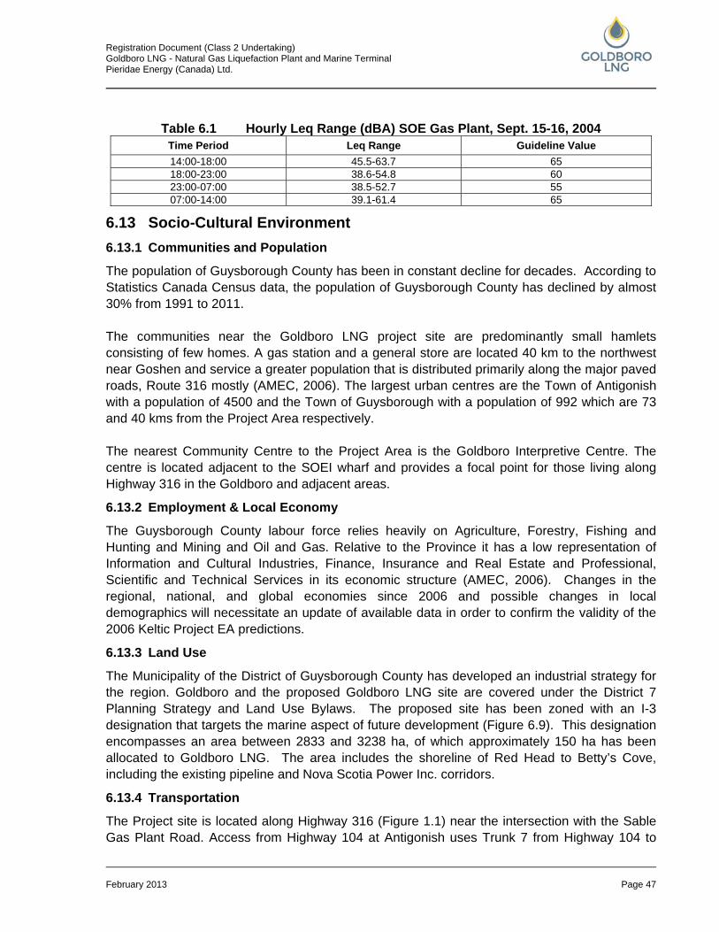
Registration Document (Class 2 Undertaking) Goldboro LNG - Natural Gas Liquefaction Plant and Marine Terminal Pieridae Energy (Canada) Ltd.
February 2013 Page 47
Table 6.1 Hourly Leq Range (dBA) SOE Gas Plant, Sept. 15-16, 2004
6.13 Socio-Cultural Environment 6.13.1 Communities and Population
The population of Guysborough County has been in constant decline for decades. According to Statistics Canada Census data, the population of Guysborough County has declined by almost 30% from 1991 to 2011. The communities near the Goldboro LNG project site are predominantly small hamlets consisting of few homes. A gas station and a general store are located 40 km to the northwest near Goshen and service a greater population that is distributed primarily along the major paved roads, Route 316 mostly (AMEC, 2006). The largest urban centres are the Town of Antigonish with a population of 4500 and the Town of Guysborough with a population of 992 which are 73 and 40 kms from the Project Area respectively. The nearest Community Centre to the Project Area is the Goldboro Interpretive Centre. The centre is located adjacent to the SOEI wharf and provides a focal point for those living along Highway 316 in the Goldboro and adjacent areas.
6.13.2 Employment & Local Economy
The Guysborough County labour force relies heavily on Agriculture, Forestry, Fishing and Hunting and Mining and Oil and Gas. Relative to the Province it has a low representation of Information and Cultural Industries, Finance, Insurance and Real Estate and Professional, Scientific and Technical Services in its economic structure (AMEC, 2006). Changes in the regional, national, and global economies since 2006 and possible changes in local demographics will necessitate an update of available data in order to confirm the validity of the 2006 Keltic Project EA predictions.
6.13.3 Land Use
The Municipality of the District of Guysborough County has developed an industrial strategy for the region. Goldboro and the proposed Goldboro LNG site are covered under the District 7 Planning Strategy and Land Use Bylaws. The proposed site has been zoned with an I-3 designation that targets the marine aspect of future development (Figure 6.9). This designation encompasses an area between 2833 and 3238 ha, of which approximately 150 ha has been allocated to Goldboro LNG. The area includes the shoreline of Red Head to Betty’s Cove, including the existing pipeline and Nova Scotia Power Inc. corridors.
6.13.4 Transportation
The Project site is located along Highway 316 (Figure 1.1) near the intersection with the Sable Gas Plant Road. Access from Highway 104 at Antigonish uses Trunk 7 from Highway 104 to
Time Period Leq Range Guideline Value 14:00-18:00 45.5-63.7 65 18:00-23:00 38.6-54.8 60 23:00-07:00 38.5-52.7 55 07:00-14:00 39.1-61.4 65

Registration Document (Class 2 Undertaking) Goldboro LNG - Natural Gas Liquefaction Plant and Marine Terminal Pieridae Energy (Canada) Ltd.
February 2013 Page 48
Route 276, Route 276 from Trunk 7 to Route 316, and Route 316 from Route 276 to Goldboro; a distance of 77 km. All are two-lane Highways with the posted speed limits at or below 80 km/h (AMEC, 2006).
6.13.5 Water Use Including Groundwater
The seasonal and permanent residences which are located outside but adjacent to the Goldboro LNG Project site derive their water from wells (AMEC, 2006). Surface water uses near the Project site include recreational fishing (e.g. Dung Cove, Betty’s Cove Brook), commercial fishing in the near-shore area, and an aquaculture operation in Country Harbour.
6.13.6 Forestry
The Project site is located in a forested area; however, it is considered non-merchantable at this time. A timber evaluation in 2003 indicated that the majority of the forest stand was immature, and had not reached commercial size. Presence of steeper terrain and wetland areas also make some of the land base non-operational (AMEC, 2006).
6.13.7 Agriculture
Agriculture operations have not been identified in, at, or near the Project site.
6.13.8 Land Ownership, Mining, and Sub-surface Rights
Gold mining has been a major resource extraction activity in Goldboro and the surrounding area. Abandoned mine sites and tailings exist throughout the site and around Goldboro (Figure 6.1 and 6.2). In recent years, the price of gold has increased to a level high enough to encourage more interest in active gold exploration and mining. Although most activity today is exploratory, there is a move to re-open the Orex site near Goldboro (http:// www.orexexploration.ca). The Goldboro LNG Project site is currently owned by the Municipality of the District of Guysborough. Several exploration licenses at and adjacent to the project site had been issued by 2005 (AMEC, 2006). More recent mapping shows that several licenses for mineral rights which include the Goldboro LNG Project Site have been issued (NSDNR, Mineral Resources Branch, 2012). It should be noted that mineral rights holders must obtain permission of the landowner to access the site for mineral exploration.
6.13.9 Tourism
The Guysborough County Heritage Association works to promote tourism, heritage, and culture in the region. The Guysborough County Heritage Association has several active members and community groups in Guysborough County. These include the Goldboro/Isaac’s Harbour Development Association, the United Empire Loyalists’ Association of Canada, Port Bickerton and Area Planning Committee, Lincolnville Community Development Society, and the Tor Bay Acadian Society. These groups seek to preserve particular aspects of the region’s heritage through promotion and/or interpretive services.
Registration Document (Class 2 Undertaking) Goldboro LNG - Natural Gas Liquefaction Plant and Marine Terminal Pieridae Energy (Canada) Ltd.
February 2013 Page 49
6.13.10 Mi’kmaq Interests
As part of the federal and provincial environmental assessments for the Keltic Project, a Mi’kmaq Ecological Knowledge (MEK) Study was conducted by Membertou Geomatics Consultants (October, 2005). The study found that, “Mi’kmaq continue to undertake traditional activities throughout the study area…As well, the data gathered regarding the various resources which are harvested by Mi’kmaq found that although these resources play an important role to Mi’kmaq, the high majority of them are found in other areas either within the study area, or in other areas of Nova Scotia…The study also found various references to a burial ground at Isaac’s Harbour and as well at Upper Country Harbour…”. (p.ii, Executive Summary, Membertou Geomatics Consultants, 2005). The significance of the area identified by the Keltic MEK Study equally applies to the Goldboro LNG Project site and current uses are assumed to remain similar. It is of note that the Goldboro LNG Project has commenced a comprehensive Aboriginal Community Engagement Strategy (Section 4.0). This engagement is expected to include a new MEK Study to confirm and up-date the significance of the Project site and surrounding lands for Aboriginal communities.
6.13.11 Archaeology and Heritage Resources
The initial Archaeological Resource Impact Assessment (ARIA) for the Keltic Project was conducted in 2004. A number of sites of potential archaeological sensitivity were identified and investigated, including some test pitting and excavations. In general, the sites were considered to have been adequately characterized. The former Red Head Cemetery (human remains having been completely removed) should be recognized as a site of heritage significance and commemorated in some fashion. The 2004 ARIA made recommendations, accepted by the provincial regulator, which included a limited pre-construction visual field survey of the five archaeological sites identified in Sculpin Cove (see Figure 6.1; Appendix A) and the area identified as “Buckley’s Farm” (probably outside the Project footprint). It is possible that an additional ARIA study was conducted subsequently, as part of the MapleLNG proposal; which will be verified through an ongoing application under the Freedom of Information Act. If excavation becomes necessary in areas of identified archaeological sensitivity, during construction or operation, then additional studies may be required.
Registration Document (Class 2 Undertaking) Goldboro LNG - Natural Gas Liquefaction Plant and Marine Terminal Pieridae Energy (Canada) Ltd.
February 2013 Page 50
7.0 ASSESSMENT PROCESS AND ANTICIPATED IMPACTS / BENEFITS 7.1 Existing Relevant Environmental Assessments The Project site is situated in an area of extensive past mining activities and developments for the energy sector. The Keltic Project EA report (AMEC, 2006) forms the basis of the description of the existing environment for the Goldboro LNG Project (Section 6.0). Some additional reports were created for the Keltic Project as required by the provincial Terms and Conditions for EA Approval. To the extent that these reports are relevant and accessible, Pieridae intends to make use of the information and incorporate it with work for the upcoming EA process. The Keltic Project LNG component was purchased by MapleLNG Ltd in 2006; however, the federal and provincial assessment processes continued under the Keltic Project title. MapleLNG Ltd. subsequently obtained a provincial permit to construct for a Gas Plant (June, 2008) and a Send Out Pipeline (September, 2009). MapleLNG Ltd. formally terminated the permits in March 2011 following a decision not to proceed with the Project. Environmental documents supporting the MapleLNG approvals will similarly be used and applied in the EA process, to the extent that they are relevant and accessible to the Proponent.
7.2 Potential Interactions and Impacts (Preliminary Screening) The Goldboro LNG Project is expected to have some interaction (large or small) with a range of valued environmental components (VECs). Table 7.1 presents the Proponent’s preliminary assessment of potential interactions. It is envisaged that these will be considered in the upcoming EA (subject to the Terms and References for the EA that is to be issued by NSE). The potential interactions identified are considered preliminary and are based partially on the assessment for the Keltic Project (AMEC, 2006) and the Proponent’s extensive experience with LNG projects such as the Kitimat LNG Facility in Emsley Cove, British Columbia. It is recognized that information on the local and regional environment will need to be reviewed and updated, but that the Project site has experienced very little change since the previous assessment. Also, several federal and provincial statutes, regulations, and permit requirements have changed and will need to be reviewed in the particular context of the Goldboro LNG Project details. Nonetheless, it is reasonable to suggest that the nature and magnitude of potential environmental effects of the Goldboro LNG Project will largely be similar to those of the Keltic Project. Therefore, the conclusions of the Keltic Project EA process and subsequent regulatory approvals (with conditions) have been used in this Registration Document to provide a preliminary understanding of potential impacts of the Goldboro LNG Project. The EA for the Keltic Project concluded that the potential impacts would be generally local and low in magnitude. This assumed the application of all mitigation as identified in the EA and implementation of additional measures as specified in regulatory approvals and permits. This conclusion was accepted by both NSE and the NSUARB. Therefore, the Proponent anticipates that, similarly, the potential for significant residual impacts to result from the Goldboro LNG Project is low. This will need to be verified or updated in the Goldboro LNG Project EA report including Project-specific mitigation and impact management measures.
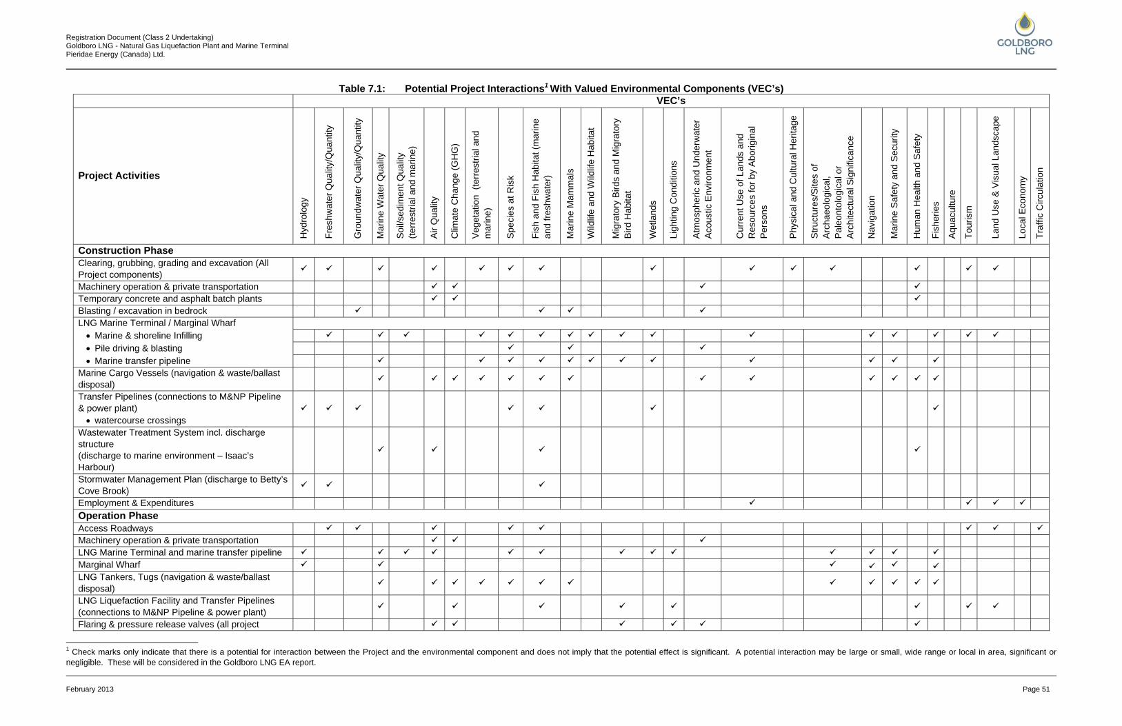
Registration Document (Class 2 Undertaking) Goldboro LNG - Natural Gas Liquefaction Plant and Marine Terminal Pieridae Energy (Canada) Ltd.
February 2013 Page 51
Table 7.1: Potential Project Interactions1 With Valued Environmental Components (VEC’s) VEC’s
Project Activities
Hyd
rolo
gy
Fres
hwat
er Q
ualit
y/Q
uant
ity
Gro
undw
ater
Qua
lity/
Qua
ntity
Mar
ine
Wat
er Q
ualit
y
Soi
l/sed
imen
t Qua
lity
(terr
estri
al a
nd m
arin
e)
Air
Qua
lity
Clim
ate
Cha
nge
(GH
G)
Veg
etat
ion
(ter
rest
rial a
nd
mar
ine)
Spe
cies
at R
isk
Fish
and
Fis
h H
abita
t (m
arin
e an
d fre
shw
ater
)
Mar
ine
Mam
mal
s
Wild
life
and
Wild
life
Hab
itat
Mig
rato
ry B
irds
and
Mig
rato
ry
Bird
Hab
itat
Wet
land
s
Ligh
ting
Con
ditio
ns
Atm
osph
eric
and
Und
erw
ater
A
cous
tic E
nviro
nmen
t
Cur
rent
Use
of L
ands
and
R
esou
rces
for b
y Ab
orig
inal
P
erso
ns
Phy
sica
l and
Cul
tura
l Her
itage
Stru
ctur
es/S
ites
of
Arc
haeo
logi
cal,
Pal
eont
olog
ical
or
Arch
itect
ural
Sig
nific
ance
Nav
igat
ion
Mar
ine
Saf
ety
and
Sec
urity
Hum
an H
ealth
and
Saf
ety
Fish
erie
s
Aqu
acul
ture
Tour
ism
Land
Use
& V
isua
l Lan
dsca
pe
Loca
l Eco
nom
y
Traf
fic C
ircul
atio
n
Construction Phase
Clearing, grubbing, grading and excavation (All Project components)
Machinery operation & private transportation Temporary concrete and asphalt batch plants Blasting / excavation in bedrock LNG Marine Terminal / Marginal Wharf • Marine & shoreline Infilling
• Pile driving & blasting
• Marine transfer pipeline Marine Cargo Vessels (navigation & waste/ballast disposal)
Transfer Pipelines (connections to M&NP Pipeline & power plant) • watercourse crossings
Wastewater Treatment System incl. discharge structure (discharge to marine environment – Isaac’s Harbour)
Stormwater Management Plan (discharge to Betty’s Cove Brook)
Employment & Expenditures
Operation Phase Access Roadways Machinery operation & private transportation LNG Marine Terminal and marine transfer pipeline Marginal Wharf LNG Tankers, Tugs (navigation & waste/ballast disposal)
LNG Liquefaction Facility and Transfer Pipelines (connections to M&NP Pipeline & power plant)
Flaring & pressure release valves (all project
1 Check marks only indicate that there is a potential for interaction between the Project and the environmental component and does not imply that the potential effect is significant. A potential interaction may be large or small, wide range or local in area, significant or negligible. These will be considered in the Goldboro LNG EA report.
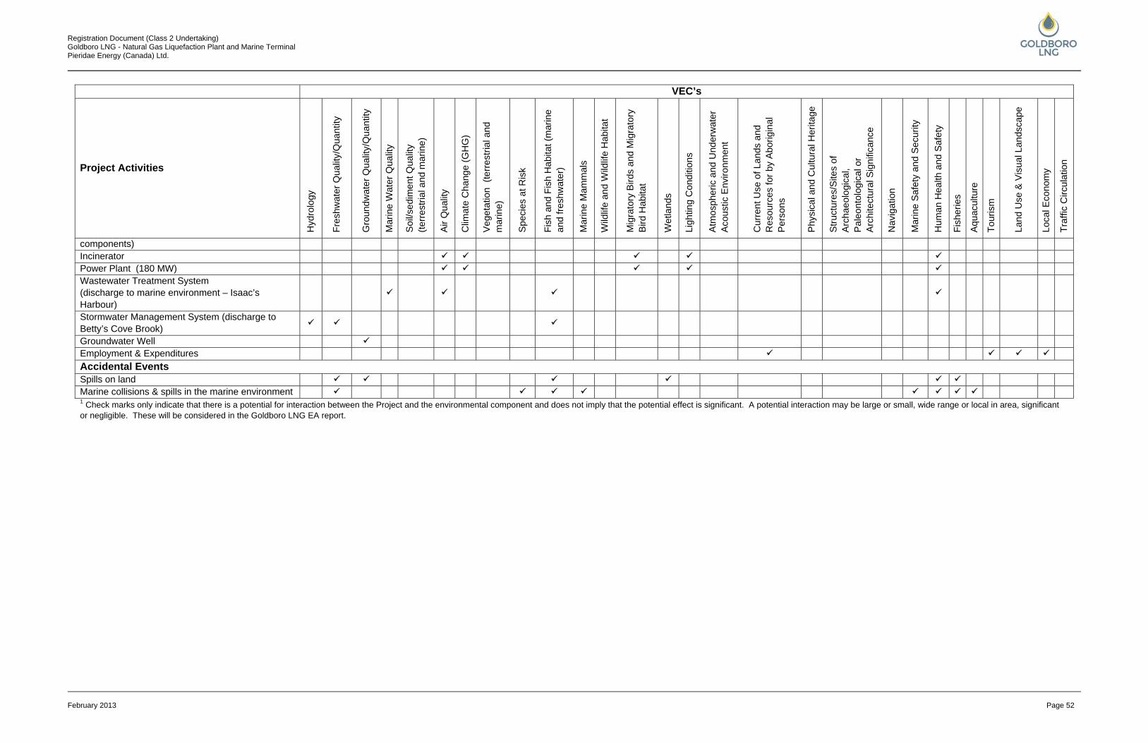
Registration Document (Class 2 Undertaking) Goldboro LNG - Natural Gas Liquefaction Plant and Marine Terminal Pieridae Energy (Canada) Ltd.
February 2013 Page 52
VEC’s
Project Activities
Hyd
rolo
gy
Fres
hwat
er Q
ualit
y/Q
uant
ity
Gro
undw
ater
Qua
lity/
Qua
ntity
Mar
ine
Wat
er Q
ualit
y
Soi
l/sed
imen
t Qua
lity
(terr
estri
al a
nd m
arin
e)
Air
Qua
lity
Clim
ate
Cha
nge
(GH
G)
Veg
etat
ion
(ter
rest
rial a
nd
mar
ine)
Spe
cies
at R
isk
Fish
and
Fis
h H
abita
t (m
arin
e an
d fre
shw
ater
)
Mar
ine
Mam
mal
s
Wild
life
and
Wild
life
Hab
itat
Mig
rato
ry B
irds
and
Mig
rato
ry
Bird
Hab
itat
Wet
land
s
Ligh
ting
Con
ditio
ns
Atm
osph
eric
and
Und
erw
ater
A
cous
tic E
nviro
nmen
t
Cur
rent
Use
of L
ands
and
R
esou
rces
for b
y Ab
orig
inal
P
erso
ns
Phy
sica
l and
Cul
tura
l Her
itage
Stru
ctur
es/S
ites
of
Arc
haeo
logi
cal,
Pal
eont
olog
ical
or
Arch
itect
ural
Sig
nific
ance
Nav
igat
ion
Mar
ine
Saf
ety
and
Sec
urity
Hum
an H
ealth
and
Saf
ety
Fish
erie
s
Aqu
acul
ture
Tour
ism
Land
Use
& V
isua
l Lan
dsca
pe
Loca
l Eco
nom
y
Traf
fic C
ircul
atio
n
components) Incinerator Power Plant (180 MW) Wastewater Treatment System (discharge to marine environment – Isaac’s Harbour)
Stormwater Management System (discharge to Betty’s Cove Brook)
Groundwater Well Employment & Expenditures
Accidental Events
Spills on land Marine collisions & spills in the marine environment 1 Check marks only indicate that there is a potential for interaction between the Project and the environmental component and does not imply that the potential effect is significant. A potential interaction may be large or small, wide range or local in area, significant or negligible. These will be considered in the Goldboro LNG EA report.
Registration Document (Class 2 Undertaking) Goldboro LNG - Natural Gas Liquefaction Plant and Marine Terminal Pieridae Energy (Canada) Ltd.
February 2013 Page 53
7.3 Cumulative Effects Individual projects and/or project components may produce residual environmental effects that are not significant, but when combined with the effects of other project components or other projects and activities, these small effects may become a concern, as they may cause a cumulative effect. A tentative list of potentially relevant future projects and activities that might interact in a cumulative fashion with the Project, both onshore and offshore, are described below.
7.3.1 Internal Project Components
Components relevant for the Cumulative Effects Assessment are the LNG Facility, 180 MW Power Plant, and Marine Terminal (including shipping). Key issues are related to climate conditions (contributions to GHG emissions), water quality (fresh and salt water), air emissions, loss and impairment of terrestrial habitat and wetlands, and changes in lighting conditions.
7.3.2 Road Upgrades and Realignments
This includes the realignment of Route 316 by the province/municipality contemporary with the Project construction. Key issues for consideration include habitat fragmentation and potential adverse effects on fish and habitat as a result of stream crossings and potential discharges to surface water environments.
7.3.3 Regional Oil and Gas and Related Developments
Other planned or reasonably foreseeable future projects related to oil and gas development that, together with the Project, may cause cumulative effects. Key concerns for potential cumulative effects relate to effects on the marine environment, navigation, and air quality. Such information will be updated from sources like the Canada Nova Scotia Offshore Petroleum Board and the NSUARB.
7.3.4 Other Projects and Activities
A more detailed consideration of potential interactions with other projects and activities will be part of the Goldboro LNG Project EA; which may include interactions with the following:
• closure of the SOEI gas plant (scheduled for 2018); • highway twinning in the Antigonish area; • Melford Terminals construction; • Black Point Quarry and associated marine terminal; • Sable Wind Project (6 large scale wind turbines - total capacity 13.8 MW) located near
Canso with anticipated commissioning date of 2015; and • two community wind energy projects (COMFIT Projects; currently under construction)
including: • 3 - 50 kw turbines located in Goldboro; and • 2 - 50 kw turbines located in Melford.
7.4 Climate Change Implications Climate change is of relevance to the Project from two perspectives. Climate change may change the way the natural, in particular the marine environment impacts the Project and its

Registration Document (Class 2 Undertaking) Goldboro LNG - Natural Gas Liquefaction Plant and Marine Terminal Pieridae Energy (Canada) Ltd.
February 2013 Page 54
operation. Plus, the Project operation is associated with greenhouse gas emissions which may contribute to climate change. In addition to general global temperature increases, climate change projections for the Project area up to the year 2080 (from AMEC, 2006) include:
• a reduction in northern hemisphere snow cover and extent of sea-ice; • global sea level rise of up to 88 cm as a result of the above; • global changes in the frequency and intensity of extreme climate events in the north
Atlantic; • more frequent heat waves and fewer cold waves and frost days; and • increased incidents of coastal sea flooding, accelerated coastal erosion and possible
increased saltwater intrusion into freshwater resources. An increase in extreme marine-related events (including increased storm intensity, winds, ocean waves, and storm surges) could result in an increased number of operation disruptions at the proposed Goldboro LNG Project marine terminal. It is possible that extreme events could increase the likelihood of accidents or malfunctions if structures were not designed to withstand frequent storms, which could lead to environmental impacts on marine fish, marine mammals, and birds. Sea level rise of the amount predicted is not by itself expected to have any potential impact on the Project. As far as the Project’s greenhouse gas emissions are concerned, this will be estimated in context of the EA report. It is noted that natural gas is associated with the least greenhouse gas emissions among all fossil fuel types.
7.5 Socio-Economic Benefits 7.5.1 Regional Economic Benefits
7.5.1.1 Employment – Construction
The Goldboro LNG Project is expected to create up to 3500 jobs during construction. The demand for employment during the construction phase will be short-term and can most likely be filled by the existing regional labour force. Since no large construction projects are anticipated for the area in the future it is unlikely that construction workers and their families would move into the region on a permanent basis.
7.5.1.2 Employment – Operation & Maintenance
The Project is expected to create up to 200 jobs during operations. It is anticipated that the majority of workers will commute to Goldboro. Some individuals in senior and other positions may move to the Guysborough/Antigonish area with their families and some families may return to find project related employment.
7.5.1.3 Spin-off Opportunities
A Project of this magnitude will bring benefits to the local and wider community both during construction and operation. These benefits include direct employment and indirect employment
Registration Document (Class 2 Undertaking) Goldboro LNG - Natural Gas Liquefaction Plant and Marine Terminal Pieridae Energy (Canada) Ltd.
February 2013 Page 55
opportunities through subcontracting, manufacturing, and the supply of goods and services to both the projects and the workforce.
7.5.1.4 Personal Income and Tax Revenue
Project expenditures and their associated multiplier effects, particularly through the construction and operation phases, have the potential to significantly increase earned income levels in the province generally and in the Guysborough/Antigonish area specifically. This results in an increase in both provincial and municipal tax revenue.
7.5.1.5 Education and Training
The magnitude of the employment will have an impact on education and training institutions within the province as a whole and the Guysborough/Antigonish area specifically, both during the construction and operations phases and for short and long-term education and training.
7.5.1.6 Aboriginal Participation
The strategy and approach to engagement and inclusion of Aboriginal peoples from the outset of the project may enhance relationships between aboriginal and non-aboriginal labour markets, thus fostering collaborative capacity building and sustained economic development in the region.
7.5.1.7 Community
The construction and operations phases of the project will bring people into the community creating opportunities to further the diversification of the economy and to continue with the enhancement of the arts and cultural initiatives already underway by local organizations.
7.5.2 Regional Energy Resource Development
The development of the Goldboro LNG Project in Nova Scotia will create: • a supplemental export market for natural gas that is not currently available; • additional government royalty revenue from increased gas sales; and • a major boost to the Nova Scotian and regional economy, resulting in enhanced
employment and direct and indirect economic benefits to the local community All of these create an opportunity for the energy industry to develop additional natural gas energy resources and advance the industry throughout the region.
7.6 Anticipated Mitigation and Monitoring In order to avoid and minimize adverse effects, to maximize Project benefits, and to comply with all applicable approvals, standards, and guidelines, the Goldboro LNG Project is expected to implement a comprehensive set of mitigation measures, monitoring programs, and contingency planning. Following is a preliminary list of anticipated key mitigation, monitoring, and planning activities: Mitigation/ Contingency Plans:
• Environmental Management Plan; • Environmental Protection Plans (General and Site Specific);
Registration Document (Class 2 Undertaking) Goldboro LNG - Natural Gas Liquefaction Plant and Marine Terminal Pieridae Energy (Canada) Ltd.
February 2013 Page 56
• Erosion and Sedimentation Control Plan; • Contingency Plan (fires/ other emergencies and discharge, emissions, escapes, leaks or
spills); • Wetland Compensation Plan; • Fish Habitat Compensation Plan (if applicable); and • Contaminated Sites Remedial Action Plan / Risk Management Plan (mine tailings). • Lighting Plan.
Project/Site Specific Studies and Monitoring:
• Air Emissions Management Plan (Incl. Greenhouse Gas); • Air Monitoring Program;
• operational emissions; • meteorological data; and • air quality dispersion.
• Environmental Effects Monitoring; and • Noise Monitoring Program.
Local Economic and Community Benefits Planning:
• Local Employment Strategy; • Local Supply and Procurement Strategy; • Equal Opportunities Employment Strategy; • Education and Training Strategy; and • Employee/Community Recreation Strategy.
The detailing of the above activities will be a focal point of the EA process. The Proponent is committed to enter into a lasting and open dialogue with local communities, Aboriginal communities, regulators, and residents to solicit input and to address specific needs and preferences on all issues related to effects management. It is envisaged that the communication and engagement will be ongoing during the planning and environmental assessment phase and extend beyond the construction into the operating phase.
Registration Document (Class 2 Undertaking) Goldboro LNG - Natural Gas Liquefaction Plant and Marine Terminal Pieridae Energy (Canada) Ltd.
February 2013 Page 57
8.0 REFERENCES Atlantic Canada Conservation Data Centre (ACCDC), 2012. Data report 4882- Response to a
data request; Septemeber14, 2012.
AMEC, 2012. Odonate Survey September 2012 (Damsel Flies and Dragon Flies): Goldboro LNG Project. 27 pp.
AMEC, 2006. Keltic Petrochemicals and Liquefied Natural Gas Facility Environmental Assessment, Goldboro, Nova Scotia. Final Report (dated July 2006).
Bird Studies Canada (BSC), 2009. The Nearshore Distribution of Terns and Other Seabirds in Relation to Industrial Developments in Stormont Bay, Nova Scotia. Final Report (dated January 7, 2009).
Chicago Bridge & Iron Company (CBI), 2013. Summary Project Description. Document No. 18532-000-PE-RP-00001, Revision A. Dated January 21, 2013.
CEAA, 2012. Canadian Environmental Assessment Act.
Keltic Petrochemicals Inc. (Keltic), 2007. Proposed Liquefied Natural Gas Facilitiy and Marginal Wharf, Comprehensive Study Report, Goldboro, Nova Scotia. Final Report (dated June 2007). Prepared by AMEC Earth & Environmental for Keltic Petrochemicals Inc. Halifax. Nova Scotia.
MapleLNG Limited (MapleLNG), 2008. Application For Permit To Construct for the proposed MapleLNG facility, dated March, 2008.
Membertou Geomatics Consultants, 2005. Mi’kmaq Ecological Knowledge Study.
Municipality of the District of Guysborough, 2001. Land Use By-law, 2011. Guysborough.
Nova Scotia Department of Natural Resources (NSDNR), 2013. General Status of Wild Species in Nova Scotia. Available at; http://www.gov.ns.ca/natr/wildlife/genstatus/; Accessed 14 January 2013.
Nova Scotia Department of Natural Resources (NSDNR), 2012 Depth- to- Water-table Mapping; available at: http://novascotia.ca/natr/forestry/GIS/; accessed September 2012.
Nova Scotia Department of Natural Resources (NSDNR), 2012. Mineral Rights information obtained from Mineral Resources Branch, 2012.
NSESA, 2012. Nova Scotia Endangered Species Act. Species at Risk Regulations made under Sections 10 and 12 of the Endangered Species Act S.N.S 1998, c.11; Order dated June5, 2000, N.S.Reg. 109/2000, as amended up to N.S.Reg.393/2007 (September 6, 2007). Available at http://www.gov.ns.ca/just/regulations/regs/eslist.htm; Accessed November 14, 2012.

Registration Document (Class 2 Undertaking) Goldboro LNG - Natural Gas Liquefaction Plant and Marine Terminal Pieridae Energy (Canada) Ltd.
February 2013 Page 58
SARA. 2012. Species at Risk Public Registry. Available at www.sararegistry.gc.ca; Accessed November 8 and 11, 2012.

Registration Document (Class 2 Undertaking) Goldboro LNG - Natural Gas Liquefaction Plant and Marine Terminal Pieridae Energy (Canada) Ltd.
APPENDIX A FIGURES
Registration Document (Class 2 Undertaking) Goldboro LNG - Natural Gas Liquefaction Plant and Marine Terminal Pieridae Energy (Canada) Ltd.
February 2013 Page A1
Figure 5.1 Project Footprint Figure 5.2 LNG Facility Layout Figure 5.3 LNG Jetty Layout Figure 6.1 Locations of Heritage Resources Figure 6.2 Abandoned Mine Workings Figure 6.3 Waterbodies and Wetlands Figure 6.4 Red Head Peninsula Surface Water Features Figure 6.5 Fish Habitat in the Vicinity of LNG Facilities Figure 6.6 Fishing Areas and Aquaculture Near Country Harbour Figure 6.7 Fish Habitat in Stormont Bay and Adjacent Areas Figure 6.8 Roseate Tern Foraging Sites and Foraging Survey Figure 6.9 Land Zoning Map

Registration Document (Class 2 Undertaking) Goldboro LNG - Natural Gas Liquefaction Plant and Marine Terminal Pieridae Energy (Canada) Ltd.
APPENDIX B TECHNICAL DRAWINGS
Registration Document (Class 2 Undertaking) Goldboro LNG - Natural Gas Liquefaction Plant and Marine Terminal Pieridae Energy (Canada) Ltd.
February 2013 Page B1
Overall Site Plan - LNG Overall Plot Plan - LNG Overall Plot Plan - Jetty & Berths LNG Jetty - Approach Trestle Details Overall Block Flow Diagram (2 sheets) Generic Liquefaction Schematic