the city of new iberia parks & recreation...
TRANSCRIPT
PRESENTATION for the New Iberia Area
• Following the 2005 Hurricane Season, the Iberia Parish Council created the Iberia Parish Hurricane Flood Protection District Advisory Committee in August 2006.
• Following the 2008 Hurricane Season, the Iberia Parish Council appointed members to the Advisory Committee in April 2009.
• In the 2010 State Legislative Regular Session, Representatives Simon Champagne, Taylor Barras and Sam Jones authored House Bill No. 713 creating the Iberia Parish Levee, Hurricane, and Conservation District. The bill was approved and signed by the Governor July 8, 2010.
History
• The Iberia Parish Levee, Hurricane, and Conservation District consist of (9) commission members who reside in the portion of Iberia Parish from which they were appointed.
• The board makeup is, (3) Members appointed by the Iberia Parish Council, (1) Member appointed by the Twin Parish Port Commission, (1) Member appointed by the Iberia Parish Port Commission and (1) Member each appointed from the City of Jeanerette, City of New Iberia, Town of Delcambre and the Village of Loreauville.
• All appointed members are subject to Senate confirmation and seated by the Governor.
Who We Are
• Ronnie Gonsoulin, Chairman (Iberia Parish Council)
• James Stein (Iberia Parish Council)
• William S. Patout III (Iberia Parish Council)
• Frank Minvielle (Iberia Parish Port Commission)
• Benson Langlinais (Twin Parish Port Commission)
• James Landry (City of New Iberia)
• Ronald Hebert, Jr. (City of Jeanerette)
• Scott Saunier (Town of Delcambre)
• Alfred “Todd” Landry (Village of Loreauville)
District Members
• To understand the dynamics of flood protection and tidal surge needs specific to Iberia Parish in order to implement a plan for such protection in conjunction with neighboring parishes and to determine and identify funding sources to implement said plan.
Mission Statement
• It took nature roughly 7,000 years and countless tons of Mississippi River sediment to build South East Louisiana.
• In the 1700’s with the settling of New Orleans and other river communities Levee’s were built to protect against storms and spring flooding.
• By the 1900’s Louisiana began to show the consequences of civilization.
• Since the 1930’s Louisiana has lost more that 1,875 square miles of land, or 1.2 million acres primarily due to human intervention. We loose on average 15,300 acres of land per year.
How did we get here?
• Levees and Jetties
• Canals and Channels dredged in the marsh
• Land Subsidence
• Saltwater Intrusion
• Invasive Species
• Sea Level Rise
Causes of Damage to Our Coastline
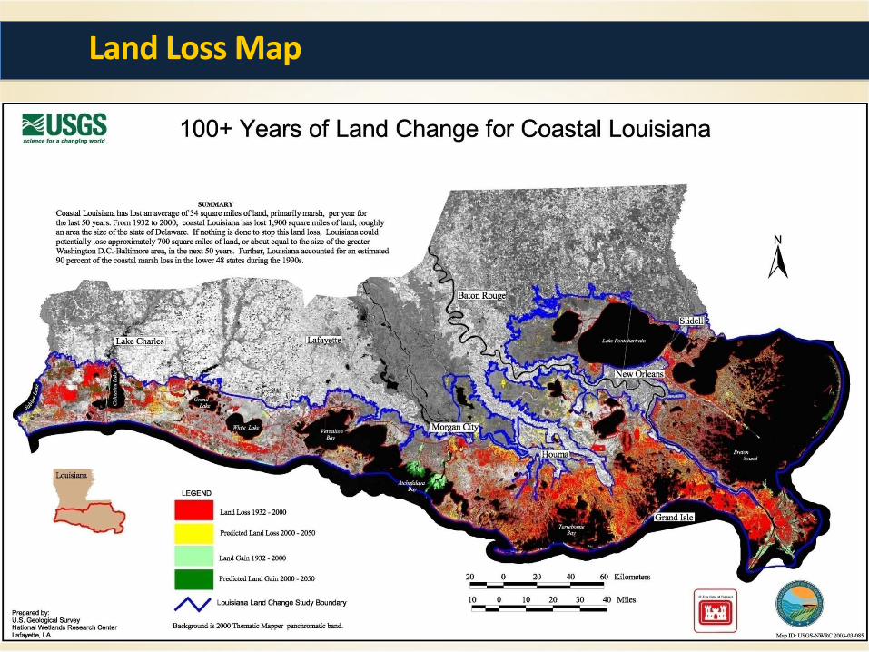
Land Loss Map
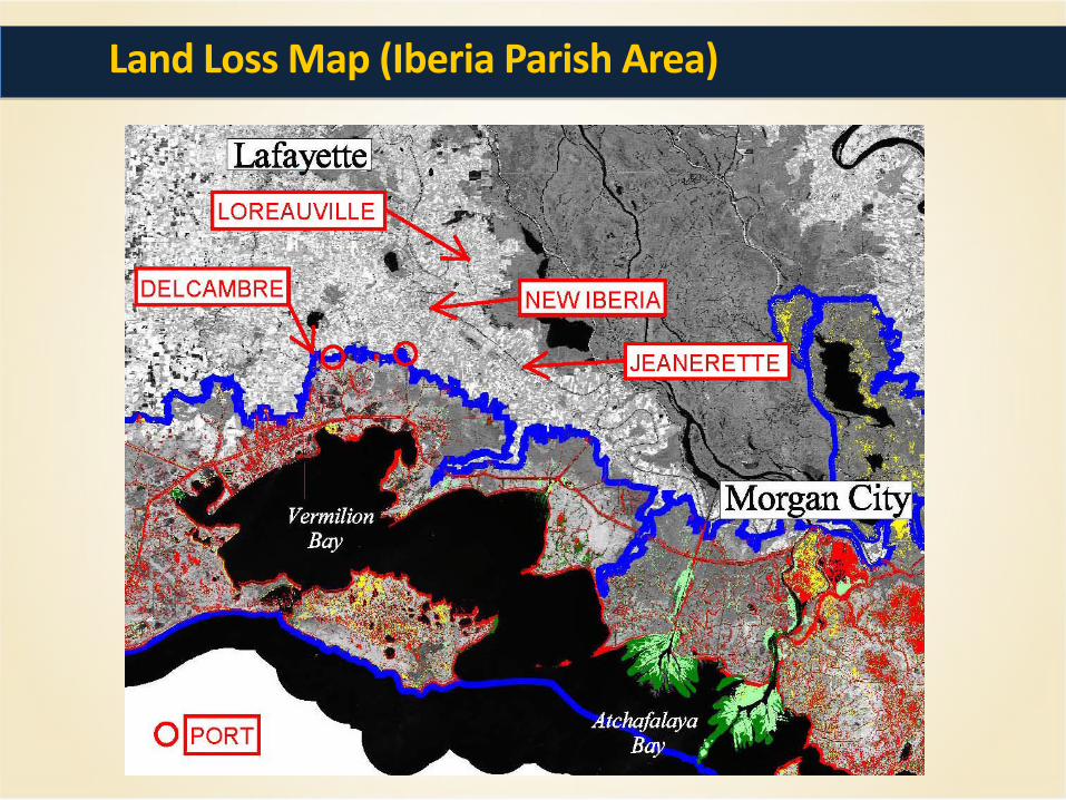
Land Loss Map (Iberia Parish Area)
• The Iberia Parish Levee, Hurricane, and Conservation District purpose is to;
• Develop types of protection for Iberia Parish excluding the Atchafalaya Basin District.
• Construct protection systems
• Maintain protection systems
• Enforce rules and regulations regarding the protection systems
Purpose
• The Iberia Parish Levee, Hurricane, and Conservation District protection systems benefits include; Hurricane Protection Maintain/Lower Insurance Rates Reduce Construction Cost Sustain agricultural lands Invites Commercial and Industrial Development Increases Job Opportunity Increases Tax Base Increases Property Values Increases Tax Revenue to all Government Bodies Maintain our Cultural and Heritage Value
• Without these protection systems all of these items will be negatively impacted from here on out.
Benefits
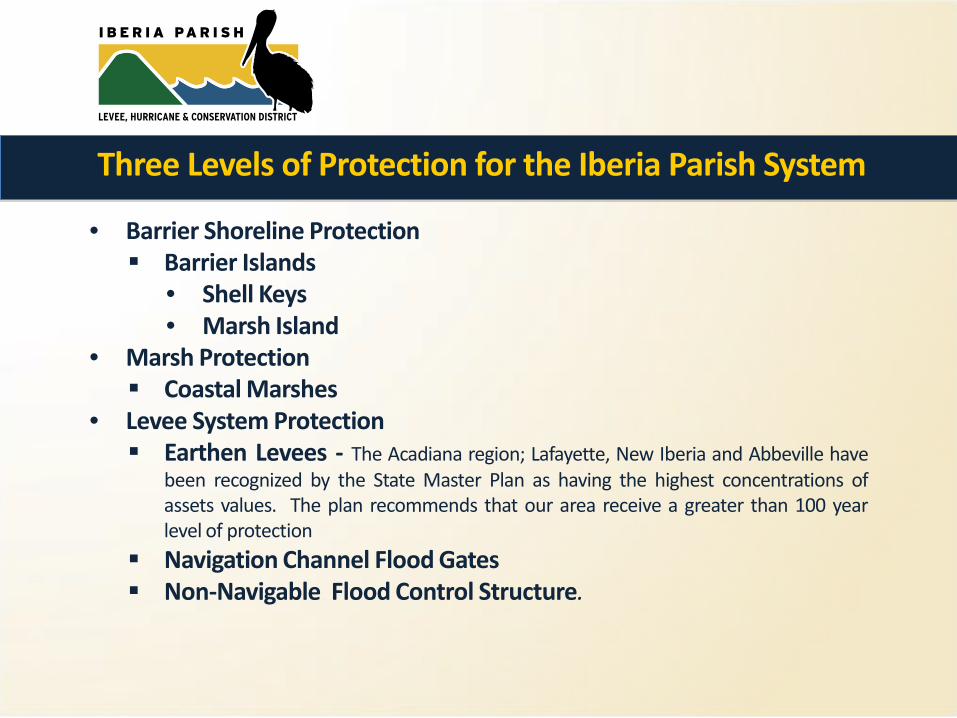
• Barrier Shoreline Protection Barrier Islands
• Shell Keys • Marsh Island
• Marsh Protection Coastal Marshes
• Levee System Protection Earthen Levees - The Acadiana region; Lafayette, New Iberia and Abbeville have
been recognized by the State Master Plan as having the highest concentrations of assets values. The plan recommends that our area receive a greater than 100 year level of protection
Navigation Channel Flood Gates Non-Navigable Flood Control Structure.
Three Levels of Protection for the Iberia Parish System
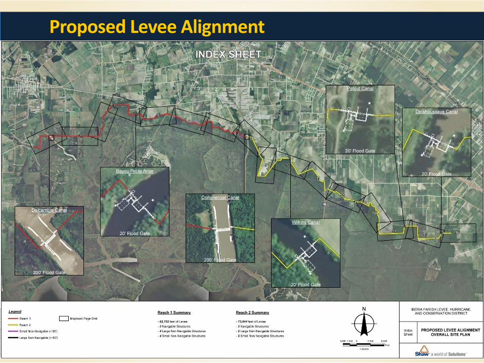
Proposed Levee Alignment
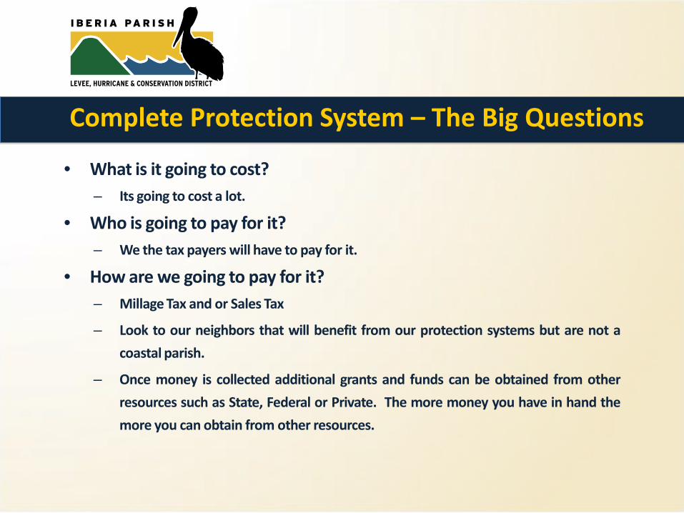
• What is it going to cost? – Its going to cost a lot.
• Who is going to pay for it? – We the tax payers will have to pay for it.
• How are we going to pay for it? – Millage Tax and or Sales Tax
– Look to our neighbors that will benefit from our protection systems but are not a
coastal parish.
– Once money is collected additional grants and funds can be obtained from other
resources such as State, Federal or Private. The more money you have in hand the
more you can obtain from other resources.
Complete Protection System – The Big Questions
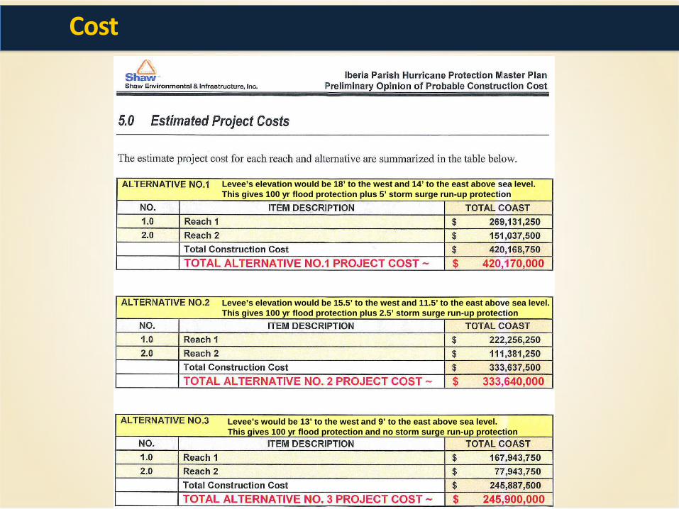
Cost
Levee’s elevation would be 18’ to the west and 14’ to the east above sea level. This gives 100 yr flood protection plus 5’ storm surge run-up protection
Levee’s elevation would be 15.5’ to the west and 11.5’ to the east above sea level. This gives 100 yr flood protection plus 2.5’ storm surge run-up protection
Levee’s would be 13’ to the west and 9’ to the east above sea level. This gives 100 yr flood protection and no storm surge run-up protection
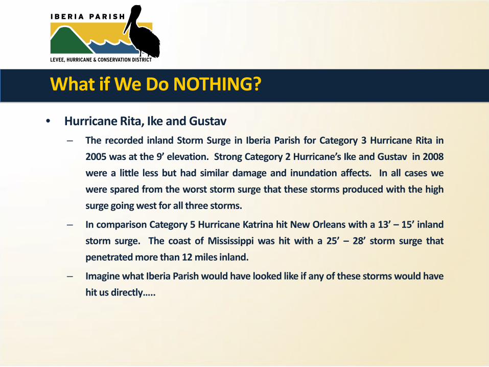
• Hurricane Rita, Ike and Gustav – The recorded inland Storm Surge in Iberia Parish for Category 3 Hurricane Rita in
2005 was at the 9’ elevation. Strong Category 2 Hurricane’s Ike and Gustav in 2008
were a little less but had similar damage and inundation affects. In all cases we
were spared from the worst storm surge that these storms produced with the high
surge going west for all three storms.
– In comparison Category 5 Hurricane Katrina hit New Orleans with a 13’ – 15’ inland
storm surge. The coast of Mississippi was hit with a 25’ – 28’ storm surge that
penetrated more than 12 miles inland.
– Imagine what Iberia Parish would have looked like if any of these storms would have
hit us directly…..
What if We Do NOTHING?
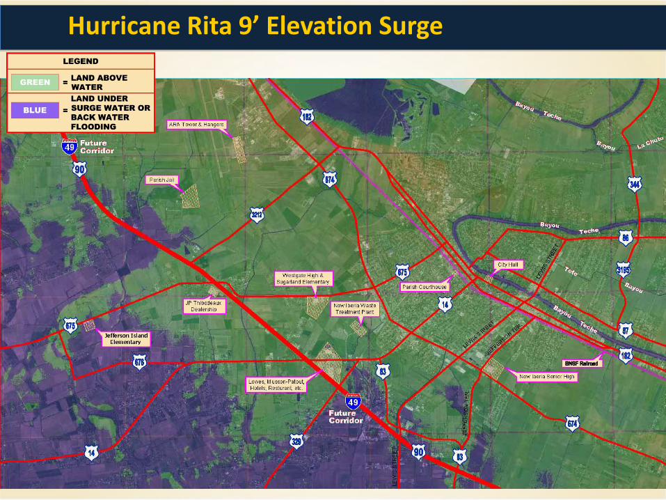
Hurricane Rita 9’ Elevation Surge
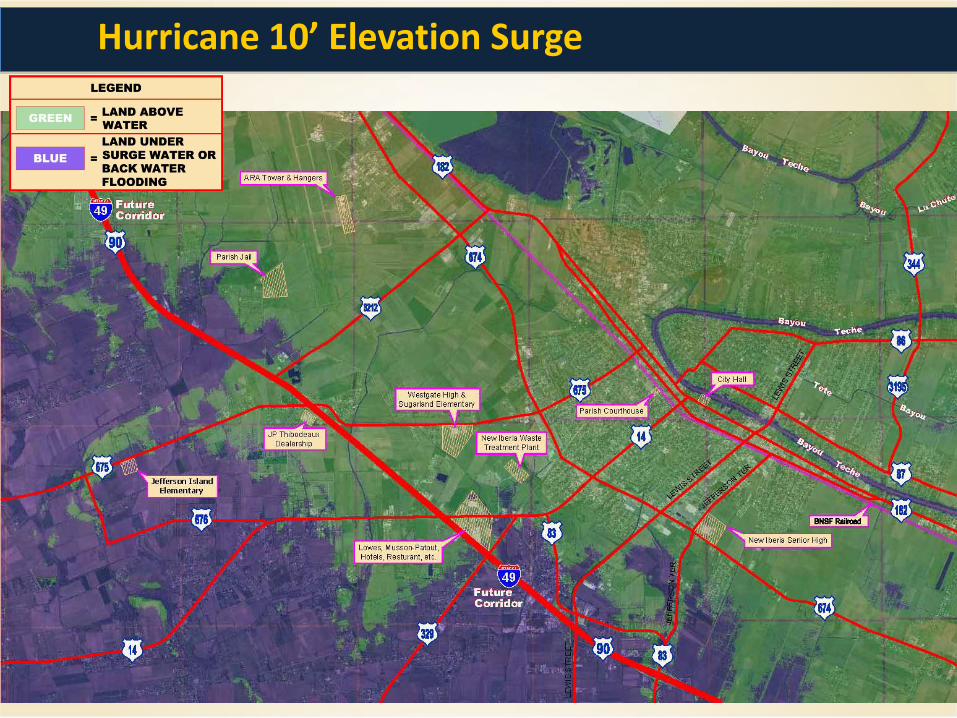
Hurricane 10’ Elevation Surge
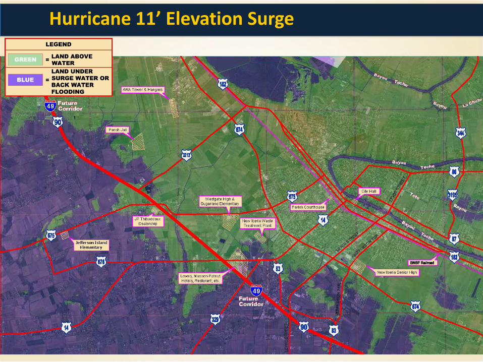
Hurricane 11’ Elevation Surge

Hurricane 12’ Elevation Surge
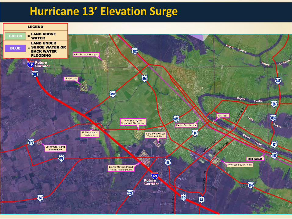
Hurricane 13’ Elevation Surge
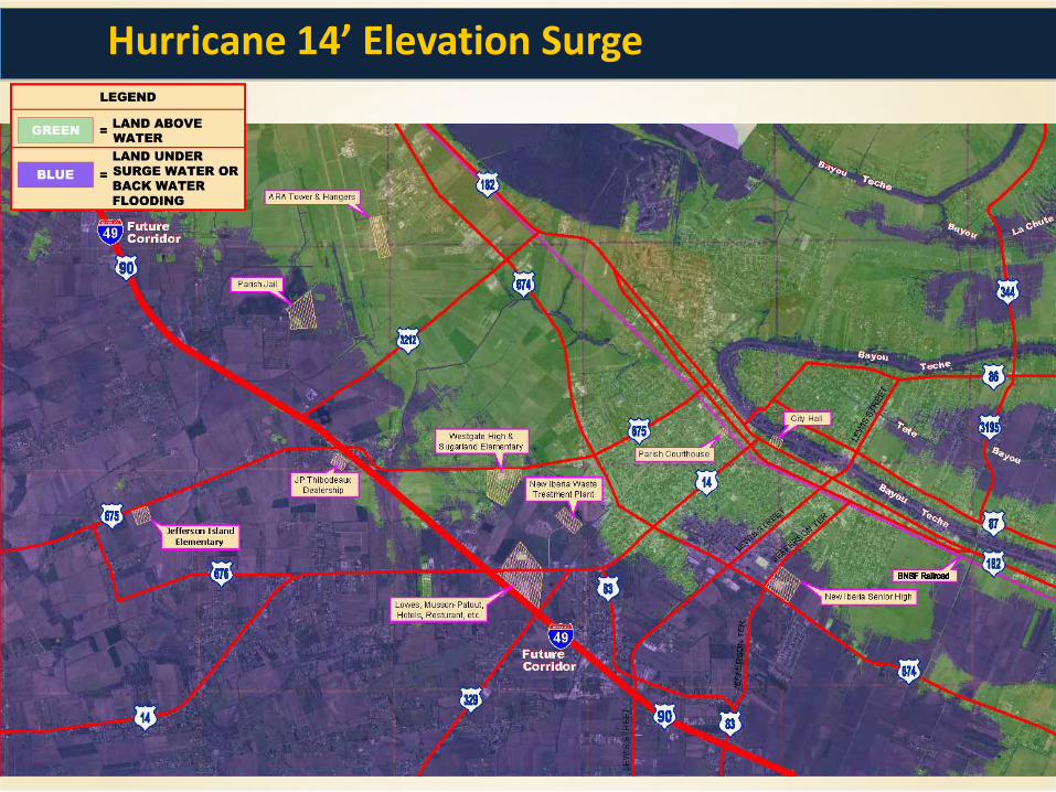
Hurricane 14’ Elevation Surge
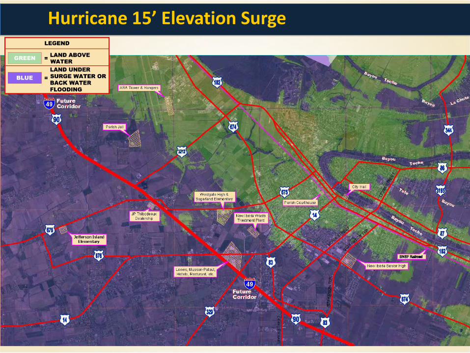
Hurricane 15’ Elevation Surge
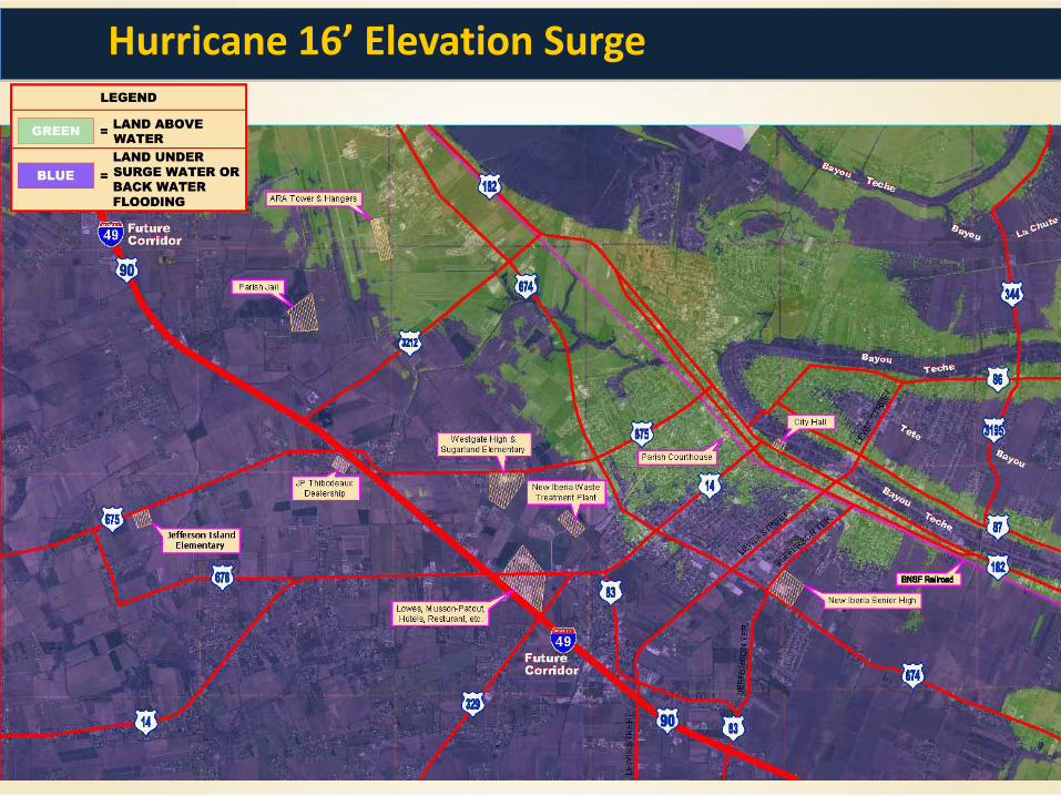
Hurricane 16’ Elevation Surge

Hurricane 17’ Elevation Surge
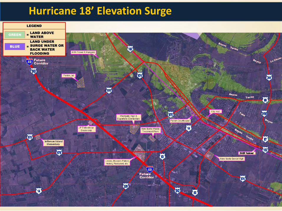
Hurricane 18’ Elevation Surge

Iberia Parish Potential 9’ Elevation Surge Impact
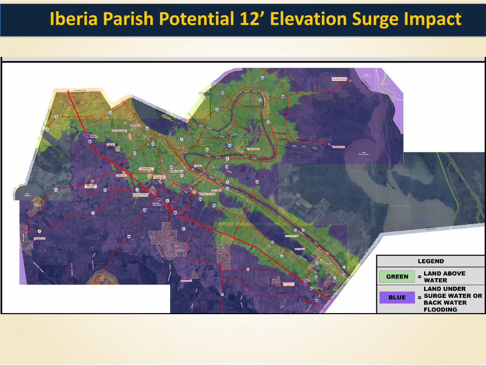
Iberia Parish Potential 12’ Elevation Surge Impact
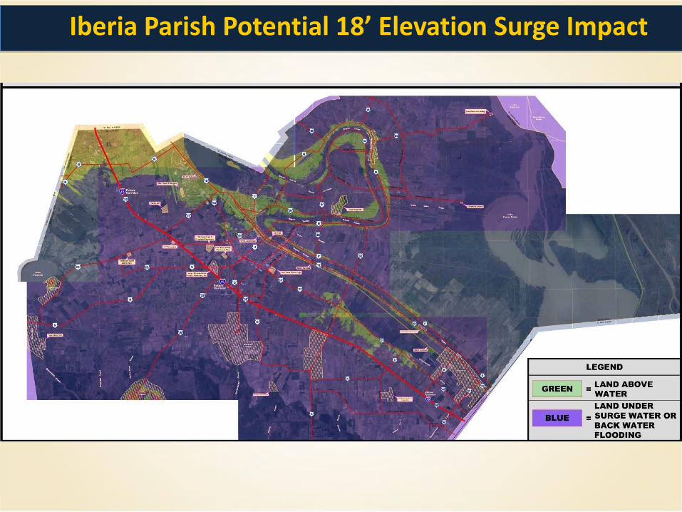
Iberia Parish Potential 18’ Elevation Surge Impact
• Where we are in 2012 – The major decline of our coast line began after we battled the Great Flood of 1927.
After that flood we constructed levee’s and control structures to protect us from the
Mississippi River and respectively the Atchafalaya Basin and cut off the marshes
supply of sediment rich water. Its taken us 80 plus years and 4 major hurricanes
(Katrina, Rita, Ike & Gustav) to understand the reality of our situation. The next 40
years are critical. The land loss map shown earlier predicts land that will be lost at
normal subsidence rates, any future hurricanes will only accelerate that land lost.
Doing nothing is NOT an option. Iberia Parish, its communities, neighboring
parishes and communities will cease to exist if we do nothing.
Who among us is ready to let that happen?
What if We Do NOTHING?
• Explanation of the Map you are about to see, – The next slide is a forecast model map of the State of Louisiana. The map shows
what the State of Louisiana will look like in the year 2100 if nothing is done. The year
2100 is only 88 years away. We don’t have until 2100 to start fixing this problem, at
that point it will be too late to save our coast and Parish.
– When you see the map, everything in the light shade of blue is considered to be
water. The land will be gone with marsh land closer to the coast, solid land is
indicated by the white or green color.
Land Loss Map Year 2100
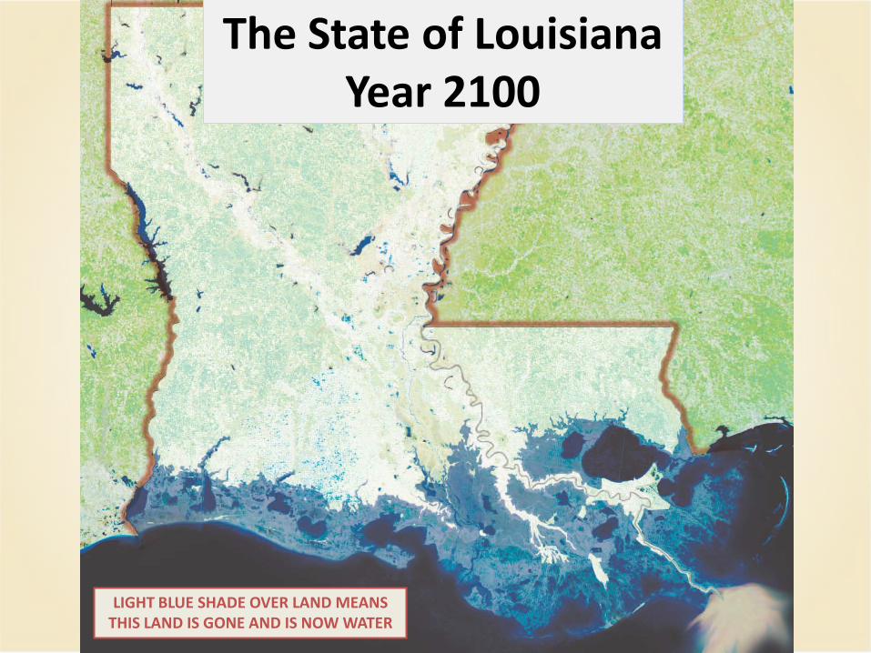
The State of Louisiana Year 2100
LIGHT BLUE SHADE OVER LAND MEANS THIS LAND IS GONE AND IS NOW WATER
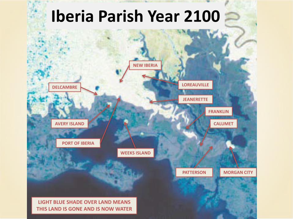
Iberia Parish Year 2100
NEW IBERIA
JEANERETTE
LOREAUVILLE DELCAMBRE
MORGAN CITY
FRANKLIN
CALUMET
PATTERSON
AVERY ISLAND
WEEKS ISLAND
PORT OF IBERIA
LIGHT BLUE SHADE OVER LAND MEANS THIS LAND IS GONE AND IS NOW WATER
• What needs to be done to move forward – Complete the Iberia Parish Hurricane Protection Master Plan
– Prioritize protection system projects
– Implement district revenue methods
– Once revenue is obtain apply for State and Federal resources
– Construct and maintain protection systems
Moving Forward
• The information provided in this presentation was accumulated from the following resources; – Coastal Protection and Restoration Authority of Louisiana
– America’s Wetland Foundation
– Louisiana State University
– Times-Picayune
– Shaw Environmental & Infrastructure, Inc.
Acknowledgements