r/v kaiyo cruise report ky09-05€¦ · r/v kaiyo cruise report ky09-05 northern japan sea –...
TRANSCRIPT
R/V KAIYO Cruise Report KY09-05
Northern Japan Sea – around the Okushiri Island –
July 31 – August 5, 2009
JAMSTEC – Naoetsu
Japan Agency for Marine-Earth Science and Technology
(JAMSTEC)

Contents
Notice on Using 1. Cruise Information ------------------------------------------------------------------------ 1 2. Researchers --------------------------------------------------------------------------------- 4 3. Research Summary ------------------------------------------------------------------------ 6
3.1 Background and Objectives --------------------------------------------------- 6 3.2 Cruise Log ------------------------------------------------------------------------ 7 3.3 Methods and Instruments --------------------------------------------------- 8
3.3.1. Bathymetry ------------------------------------------------------------ 8 3.3.2. Single-channel Seismic Survey --------------------------------- 9 3.3.3 Piston Coring --------------------------------------------------------- 9 3.3.4. Heat Flow Measurement ------------------------------------------ 9
3.4 Onboard Results --------------------------------------------------------------- 12 3.4.1. Bathymetry ------------------------------------------------------------ 12 3.4.2. Single-channel Seismic Survey --------------------------------- 12 3.4.3 Piston Coring --------------------------------------------------------- 15 3.4.4. Heat Flow Measurement ------------------------------------------ 17
Acknowledgements Appendix I
Equipment, Survey Specification, and General Information of SCS Survey Appendix II
Summary of Piston Coring Operation

Notice on using
This cruise report is a preliminary documentation as of the end of the cruise. This report may not be corrected even if changes on contents (i.e. taxonomic
classifications) may be found after its publication. This report may also be changed without notice. Data on this cruise report may be raw or unprocessed. If you are going to use or refer to the data written on this report, please ask the Chief Scientist for latest information.
Users of data or results on this cruise report are requested to submit their
results to the Data Integration and Analysis Group (DIAG) of JAMSTEC.
- 1 -
1. Cruise Information
Ship Name:
R/V Kaiyo Title of the cruise:
Northern Japan Sea – around the Okushiri Island Title of the Proposal:
Integrated survey of bio-geochemical processes of the evolution of methane hydrate and methane plumes in the eastern margin of Japan Sea
Cruise Period:
July 31 ‒ August 5, 2009 Ports of Call:
July 31 Departure JAMSTEC Pier, Yokosuka, Kanagawa August 5 Arrival Naoetsu Port, Niigata
Research Area:
West of the Okushiri Island (east of the Japan Basin), eastern margin of Japan Sea (Figs. 1 and 2)

- 2 -
Fig. 1. Index map of the research area in the KY09-05 Cruise.

- 3 -
Fig. 2. Ship track of the KY09-05 Cruise.
- 4 -
2. Researchers (Science Party)
Chief Scientist (Representative of the Science Party):
Matsumoto, Ryo (University of Tokyo) Onboard Scientists:
Anzai, Hiroya (Gakushuin University) Aoyama, Chiharu (Japan’s Independent Institute Co., Ltd.) Collo, Fernando (University of Tokyo) Freire, Fernando (University of Tokyo) Hiromatsu, Mineo (University of Tokyo) Hiruta, Akihiro (University of Bremen) Ito, Kaori (University of Tokyo) Kakuwa, Yoshitaka (University of Tokyo) Ketzer, Joao Marcelo (University of Tokyo) Lu, Hailong (University of Tokyo) Machiyama, Hideaki (JAMSTEC) Matsuda, Nilo (University of Tokyo) Suzuki, Maki (University of Tokyo) Tomaru, Hitoshi (University of Tokyo)
Shore-based Scientists:
Aizawa, Shoichi (Gunma University) Akiba, Fumio (Diatom Minilab Akiba, Co. Ltd.) Fujikura, Katsunori (JAMSTEC) Fujiwara, Yoshihiro (JAMSTEC) Inagaki, Fumio (JAMSTEC) Joshima, Masato (AIST) Kinoshita, Masataka (JAMSTEC) Matsukura, Seiya (University of Tokyo) Muramatsu, Yasuyuki (Gakushuin University) Numanami, Hideki (Tokyo Kasei Gakuin University) Ogihara, Shigenori (University of Tokyo) Sannou, Risa (University of Tokyo) Sunamura, Michinari (University of Tokyo) Tsuchinaga, Kazuhiro (University of Tokyo) Uchida, Takashi (Akita University)
- 5 -
Yamano, Makoto (Earthquake Research Institute, University of Tokyo) Yamashita, Satoshi (Kitami Institute of Technology) Yanagawa, Katsunori (University of Tokyo)

- 6 -
3. Research Summary
3.1. Background and Objectives
Methane hydrate is a solid material composed of methane and water molecules, and is expected to become new energy resource. Methane hydrate is also important as an environmental mediator which drastically modifies carbon cycle on the earth’s surface. We recognized methane plumes and recovered massive methane hydrate near surface sediments off Naoetsu, Joetsu Basin in 2004. Since then, we conducted a series of surveys including an ocean floor survey by ROV Hyper-Dolphin, piston coring, and single-channel seismic survey (SCS survey), and reached a hypothesis that massive accumulation of methane hydrate in Joetsu Basin is closely related with the origin and evolution of Japan Sea. In 2007, we expanded survey area to the entire eastern margin of Japan Sea from off Joetsu to the west of Hokkaido, and conducted SCS survey, ROV dives, and piston coring in the Shiribeshi Trough and west of Okushiri Island, Hokkaido, in 2008. 2008 surveys have revealed that the depth of SMI (sulfate-methane interface) on a small ridge (“West Okushiri Ridge”) in the west of Okushiri Island is only 1 m, which suggests extremely high flux of methane. On the other hand, there are a number of large-scale pockmark-like structures in the Okushiri Basin, which are quite similar to pockmarks on the Umitaka Spur of the Joetsu Basin and are likely to suggest large scale methane seeps.
The objectives of this cruise are: (1) To determine the methane flux by taking a number of piston cores from the
BSR (bottom simulating reflector) area, (2) To identify methane induced carbonate crust and nodules, and (3) To recover methane hydrate
in the Area A, and (4) To know if large scale depressions are methane induced pockmarks or not in
the Area B.
Unfortunately, bathymteric survey in the Okushiri Basin (Area B) was cancelled, because many squid boats were operating around the survey line.

- 7 -
3.2 Cruise Log
Date Activity & Operation Area July 30 31 August 1 2 3 4 5
Embarkation Departure/ Transit Briefing/ Science Meeting Transit Science Meeting Transit/ Survey XBT/ Bathymetry (MBES) Piston Coring (PC01) Science Meeting Bathymetry (MBES)/ SCS Survey (in the night) Survey Piston Coring (PC02, 03, 04) Science Meeting Transit Science Meeting Disembarkation
JAMSTEC Pier, Yokosuka Area A (West of Okushiri Island) Area A (West of Okushiri Island) Naoetsu Port, Niigata

- 8 -
3.3 Methods and Instruments 3.3.1 Bathymetry
Bathymetric survey was carried out by MBES (multi-beam echo sounder) using SEABEAM 2100 system (Frequency: 12 kHz). Water temperature profile obtained by XBT is shown in Fig. 3.
Fig. 3 Water temperature profile obtained by XBT for bathymetric survey.

- 9 -
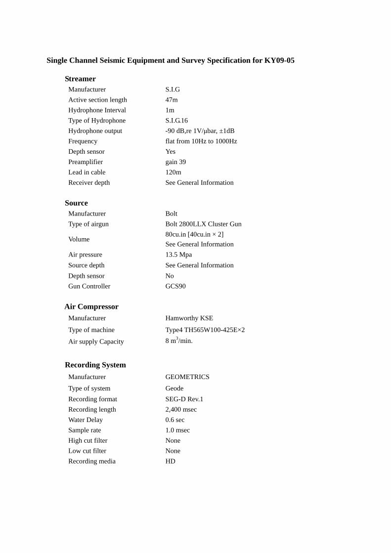
3.3.2 Single-channel Seismic Survey (SCS survey) Single-channel seismic survey was conducted around the Area A. We used Bolt
2800LLX Cluster Gun and S.I.G. 16 Streamer Cable systems for the SCS survey. This cluster gun system is good for imaging shallow part, especially BSR. Equipments and main specifications of SCS system is as follows (see details in Appendix I).
Cluster gun system Type of airgun Bolt 2800LLX Cluster Gun Volume 80cu.in (40cu.in × 2) Air pressure 13.5 MPa Source depth 1.5 m
S.I.G. 16 Streamer cable Active section length 47m No. of hydrophones 48 Hydrophone interval 1m Frequency flat from 10Hz to 1000Hz Receiver depth 2 m
3.3.3 Piston Coring
Piston core sampler consists of an 800 kg-weight, 6 m-long or 8 m-long stainless steel core barrel with a PVC (polyvinyl chloride) inner tube, and a pilot core sampler (Fig. 4). We used a Ewing-type corer and a small multiple corer, called “Ashura”, as a pilot core sampler. Detailed operations in each piston coring are summarized in Appendix II. 3.3.4 Heat Flow Measurement
Heat flow measurement was conducted by a HFPC (Heat Flow Piston Corer), which is a piston corer equipped with several small temperature data loggers (ANTARES Temperature Datalogger) along a core barrel, under the coring operation (Fig. 4).
Specifications of the heat flow probe are as follows. Sensor thermistor (φ 4 mm) Resolution about 1 mK Recording interval 10 sec. No. of sensors 5 — 7 Sensor vertical interval 50 — 70 cm Measurement time about 20 min.
In order to obtain reference temperature data, the HFPC was left still for 10 minutes about 50 m above the seafloor before penetration. After penetration into the
- 10 -
sediments, HFPC was left in the sediments for 20 minutes to avoid the frictional heat generated by the core barrel.
Thermal conductivities were measured on core samples, using the QTM (Quick Thermal Conductivity Meter). Each archive half section was used for QTM. Quartz glass, silicone rubber, and polystyrene foam are used as standard samples for calibration.

- 11 -
Fig. 4 Configuration of piston coring system in the KY09-05 Cruise.
- 12 -
3.4 Onboard Results 3.4.1 Bathymetry
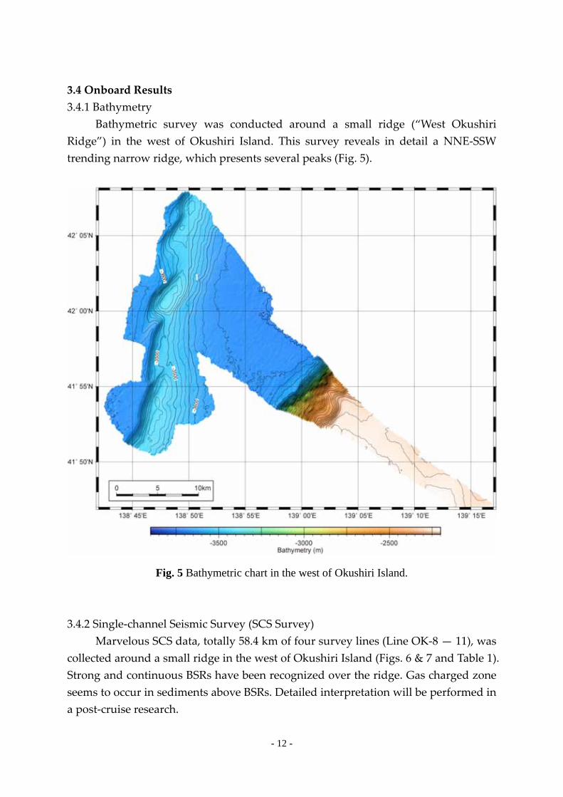
Bathymetric survey was conducted around a small ridge (“West Okushiri Ridge”) in the west of Okushiri Island. This survey reveals in detail a NNE-SSW trending narrow ridge, which presents several peaks (Fig. 5).
Fig. 5 Bathymetric chart in the west of Okushiri Island. 3.4.2 Single-channel Seismic Survey (SCS Survey)
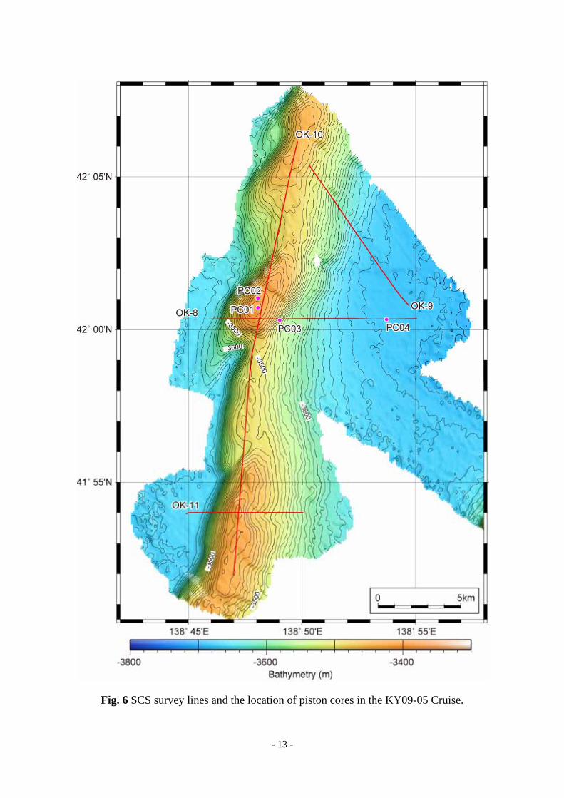
Marvelous SCS data, totally 58.4 km of four survey lines (Line OK-8 — 11), was collected around a small ridge in the west of Okushiri Island (Figs. 6 & 7 and Table 1). Strong and continuous BSRs have been recognized over the ridge. Gas charged zone seems to occur in sediments above BSRs. Detailed interpretation will be performed in a post-cruise research.
- 13 -
Fig. 6 SCS survey lines and the location of piston cores in the KY09-05 Cruise.

- 14 -
Fig. 7 SCS profiles.
Table 1 Line list of SCS survey.
4 42-00.34698 N 138-44.86816 E2007 42-00.35454 N 138-55.15045 E
3 42-00.84045 N 138-54.64325 E1169 42-05.43663 N 138-50.26978 E
3 42-06.09993 N 138-49.79462 E4150 41-51.88957 N 138-46.97754 E
3 41-53.98315 N 138-44.96979 E1007 41-54.00192 N 138-50.14893 E
OK-9 10430
OK-10 26589
OK-11 7163
Length (m)Latitude Longitude
OK-8 14197
Line No. Shot No.Vessel Position

- 15 -
3.4.3 Piston Coring We obtained four piston cores in this cruise. Stations PC01 and PC02 are on a
summit of the ridge (Fig. 6). Station PC03 is on the slope of the ridge, and Station PC04 is in the western part of the basin. These two stations are also on the Line OK-8 of SCS survey (Fig. 6). The results of piston core sampling are shown in Table 2 and Figures 8 and 9. All cores consist mainly of alternation of dark- and light-colored laminated layers and intercalated with thin ash layers. Inorganic and organic geochemical analysis, such as interstitial water chemistry, and micropaleontological analysis are scheduled in a post-cruise research.
Table 2 Summary of piston core sampling in the KY09-05 Cruise.
Fig. 8 Core summary
Core No. Date Latitude Longitude Depth (m) Recovery (cm)PC01 2009/8/2 42°00.7230'N 138°48.0656'E 3403 498PC02 2009/8/3 42°01.0319'N 138°48.0656'E 3409 426PC03 2009/8/3 42°00.3139'N 138°49.0251'E 3509 688PC04 2009/8/3 42°00.3322'N 138°53.7239'E 3682 541

- 16 -
Fig. 9 Scanned photographs of each core section.

- 17 -
3.4.4. Heat Flow Measurement Heat flow measurement was conducted using a Ewing-type heat flow probe in
the Station PC02 (summit of the ridge) and PC04 (basin floor) (Fig. 6). Both results are good, and show a linear temperature profile (Fig. 10). Geothermal gradient value (onboard tentative value) of Station PC02 and PC04 is 115 mK/m and 128 mK/m, respectively. The value of the basin floor is slightly higher than that of the summit of the ridge. Onboard measurement of thermal conductivity was finished by the end of cruise. Heat flow calculation will be performed in a post-cruise research.
Fig. 10 Time–temperature and temperature–depth profiles in each station.

- 18 -
Acknowledgements We are grateful to Captain Kouji Sameshima, the crew of R/V Kaiyo, and marine
technicians for their professional support during this cruise. We also thank Research Vessel Management and Operations Department of JAMSTEC for their kind and helpful supports.

Appendix I
Equipment, Survey Specification, and General Information of SCS Survey
Single Channel Seismic Equipment and Survey Specification for KY09-05
Streamer Manufacturer S.I.G Active section length 47m Hydrophone Interval 1m Type of Hydrophone S.I.G.16 Hydrophone output -90 dB,re 1V/μbar, ±1dB Frequency flat from 10Hz to 1000Hz Depth sensor Yes Preamplifier gain 39 Lead in cable 120m Receiver depth See General Information Source Manufacturer Bolt Type of airgun Bolt 2800LLX Cluster Gun
Volume 80cu.in [40cu.in × 2] See General Information
Air pressure 13.5 Mpa Source depth See General Information Depth sensor No
Gun Controller GCS90
Air Compressor Manufacturer Hamworthy KSE
Type of machine Type4 TH565W100-425E×2
Air supply Capacity 8 m3/min.
Recording System
Manufacturer GEOMETRICS
Type of system Geode Recording format SEG-D Rev.1 Recording length 2,400 msec Water Delay 0.6 sec Sample rate 1.0 msec High cut filter None Low cut filter None Recording media HD

GPS System Manufacturer Fugro Type of system SkyFix XP DGPS Reference Station ALL GPS System Manufacturer MARIMEX JAPAN Type of system NAVLOG Shot Point Geometry Time mode shooting See General Information Geodetic Parameter Spheroid WGS84 Semi-major Axis 6,378,137m Inverse Flattening 298.26
Projection U.T.M Zone54

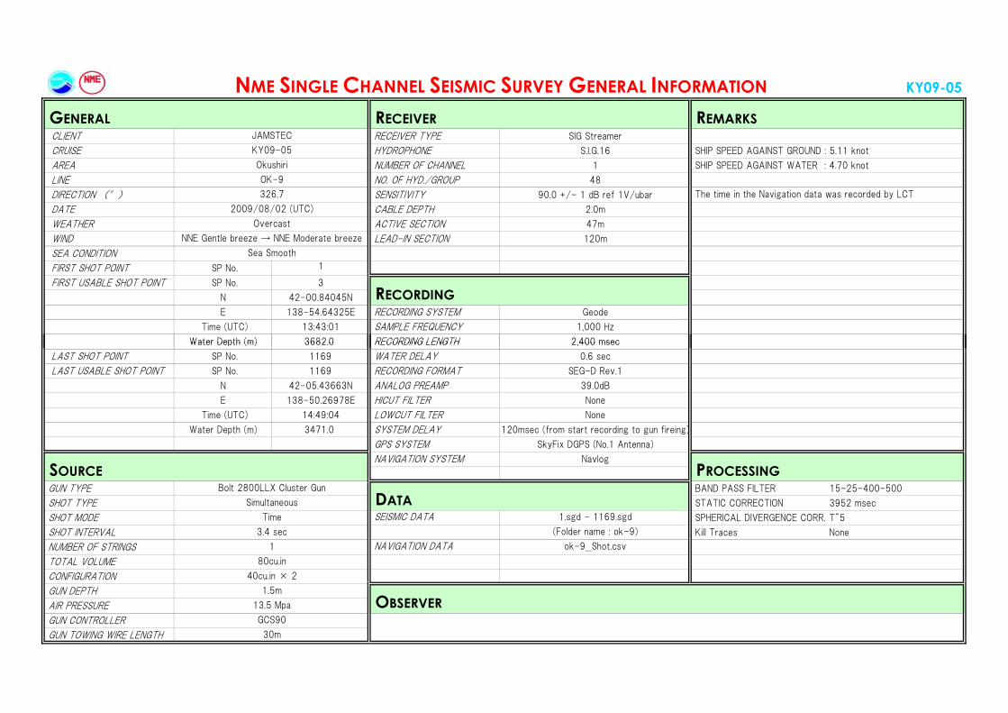
KY09-05
CLIENT RECEIVER TYPE SIG Streamer
CRUISE HYDROPHONE S.I.G.16 SHIP SPEED AGAINST GROUND : 4.05 knot
AREA NUMBER OF CHANNEL 1 SHIP SPEED AGAINST WATER : 4.06 knot
LINE NO. OF HYD./GROUP 48
DIRECTION (°) SENSITIVITY 90.0 +/- 1 dB ref 1V/ubar
DATE CABLE DEPTH 2.0m
WEATHER ACTIVE SECTION 47m
WIND LEAD-IN SECTION 120m
SEA CONDITION
FIRST SHOT POINT SP No. 1
FIRST USABLE SHOT POINT SP No. 4
N 42-00.34698N
E 138-44.86816E RECORDING SYSTEM Geode
Time (UTC) 11:36:-- SAMPLE FREQUENCY 1,000 Hz
Water Depth (m) 3656 0 RECORDING LENGTH 2 400 msec
NME SINGLE CHANNEL SEISMIC SURVEY GENERAL INFORMATION
RECEIVERJAMSTEC
REMARKS GENERAL
KY09-05
Overcast
NNE Gentle breeze → NNE Moderate breeze
Sea Smooth
2009/08/02 (UTC)
Okushiri
RECORDING
OK-8
91.4 Time record in the Navigation data was deffective.
Water Depth (m) 3656.0 RECORDING LENGTH 2,400 msec
LAST SHOT POINT SP No. 2007 WATER DELAY 0.6 sec
LAST USABLE SHOT POINT SP No. 2007 RECORDING FORMAT SEG-D Rev.1
N 42-00.35454N ANALOG PREAMP 39.0dB
E 138-55.15045E HICUT FILTER None
Time (UTC) 13:30:-- LOWCUT FILTER None
Water Depth (m) 3687.0 SYSTEM DELAY 120msec (from start recording to gun fireing)
GPS SYSTEM SkyFix DGPS (No.1 Antenna)
NAVIGATION SYSTEM Navlog
GUN TYPE BAND PASS FILTER 15-25-400-500
SHOT TYPE STATIC CORRECTION 3952 msec
SHOT MODE SEISMIC DATA 1.sgd - 2007.sgd SPHERICAL DIVERGENCE CORR. T^5
SHOT INTERVAL (Folder name : ok-8) Kill Traces None
NUMBER OF STRINGS NAVIGATION DATA ok-8__Shot.csv
TOTAL VOLUME
CONFIGURATION
GUN DEPTH
AIR PRESSURE
GUN CONTROLLER
GUN TOWING WIRE LENGTH
Time
Bolt 2800LLX Cluster Gun
Simultaneous
1.5m
40cu.in × 2
80cu.in
3.4 sec
1
SOURCE
30m
GCS90
OBSERVER13.5 Mpa
DATA
PROCESSING
KY09-05
CLIENT RECEIVER TYPE SIG Streamer
CRUISE HYDROPHONE S.I.G.16 SHIP SPEED AGAINST GROUND : 5.11 knot
AREA NUMBER OF CHANNEL 1 SHIP SPEED AGAINST WATER : 4.70 knot
LINE NO. OF HYD./GROUP 48
DIRECTION (°) SENSITIVITY 90.0 +/- 1 dB ref 1V/ubar
DATE CABLE DEPTH 2.0m
WEATHER ACTIVE SECTION 47m
WIND LEAD-IN SECTION 120m
SEA CONDITION
FIRST SHOT POINT SP No. 1
FIRST USABLE SHOT POINT SP No. 3
N 42-00.84045N
E 138-54.64325E RECORDING SYSTEM Geode
Time (UTC) 13:43:01 SAMPLE FREQUENCY 1,000 Hz
Water Depth (m) 3682 0 RECORDING LENGTH 2 400 msec
2009/08/02 (UTC)
JAMSTEC
NME SINGLE CHANNEL SEISMIC SURVEY GENERAL INFORMATION
GENERAL RECEIVER REMARKS
KY09-05
Okushiri
OK-9
326.7 The time in the Navigation data was recorded by LCT
Sea Smooth
RECORDING
Overcast
NNE Gentle breeze → NNE Moderate breeze
Water Depth (m) 3682.0 RECORDING LENGTH 2,400 msec
LAST SHOT POINT SP No. 1169 WATER DELAY 0.6 sec
LAST USABLE SHOT POINT SP No. 1169 RECORDING FORMAT SEG-D Rev.1
N 42-05.43663N ANALOG PREAMP 39.0dB
E 138-50.26978E HICUT FILTER None
Time (UTC) 14:49:04 LOWCUT FILTER None
Water Depth (m) 3471.0 SYSTEM DELAY 120msec (from start recording to gun fireing)
GPS SYSTEM SkyFix DGPS (No.1 Antenna)
NAVIGATION SYSTEM Navlog
GUN TYPE BAND PASS FILTER 15-25-400-500
SHOT TYPE STATIC CORRECTION 3952 msec
SHOT MODE SEISMIC DATA 1.sgd - 1169.sgd SPHERICAL DIVERGENCE CORR. T^5
SHOT INTERVAL (Folder name : ok-9) Kill Traces None
NUMBER OF STRINGS NAVIGATION DATA ok-9__Shot.csv
TOTAL VOLUME
CONFIGURATION
GUN DEPTH
AIR PRESSURE
GUN CONTROLLER
GUN TOWING WIRE LENGTH
SOURCE PROCESSING
3.4 sec
1
80cu.in
Bolt 2800LLX Cluster Gun
DATASimultaneous
Time
30m
40cu.in × 2
1.5m
OBSERVER13.5 Mpa
GCS90
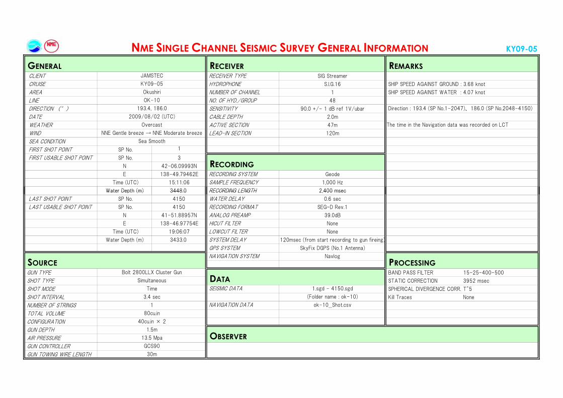
KY09-05
CLIENT RECEIVER TYPE SIG Streamer
CRUISE HYDROPHONE S.I.G.16 SHIP SPEED AGAINST GROUND : 3.68 knot
AREA NUMBER OF CHANNEL 1 SHIP SPEED AGAINST WATER : 4.07 knot
LINE NO. OF HYD./GROUP 48
DIRECTION (°) SENSITIVITY 90.0 +/- 1 dB ref 1V/ubar
DATE CABLE DEPTH 2.0m
WEATHER ACTIVE SECTION 47m
WIND LEAD-IN SECTION 120m
SEA CONDITION
FIRST SHOT POINT SP No. 1
FIRST USABLE SHOT POINT SP No. 3
N 42-06.09993N
E 138-49.79462E RECORDING SYSTEM Geode
Time (UTC) 15:11:06 SAMPLE FREQUENCY 1,000 Hz
Water Depth (m) 3448 0 RECORDING LENGTH 2 400 msec
2009/08/02 (UTC)
JAMSTEC
NME SINGLE CHANNEL SEISMIC SURVEY GENERAL INFORMATION
GENERAL RECEIVER REMARKS
KY09-05
Okushiri
OK-10
193.4, 186.0 Direction : 193.4 (SP No.1-2047)、186.0 (SP No.2048-4150)
Sea Smooth
RECORDING
Overcast The time in the Navigation data was recorded on LCT
NNE Gentle breeze → NNE Moderate breeze
Water Depth (m) 3448.0 RECORDING LENGTH 2,400 msec
LAST SHOT POINT SP No. 4150 WATER DELAY 0.6 sec
LAST USABLE SHOT POINT SP No. 4150 RECORDING FORMAT SEG-D Rev.1
N 41-51.88957N ANALOG PREAMP 39.0dB
E 138-46.97754E HICUT FILTER None
Time (UTC) 19:06:07 LOWCUT FILTER None
Water Depth (m) 3433.0 SYSTEM DELAY 120msec (from start recording to gun fireing)
GPS SYSTEM SkyFix DGPS (No.1 Antenna)
NAVIGATION SYSTEM Navlog
GUN TYPE BAND PASS FILTER 15-25-400-500
SHOT TYPE STATIC CORRECTION 3952 msec
SHOT MODE SEISMIC DATA 1.sgd - 4150.sgd SPHERICAL DIVERGENCE CORR. T^5
SHOT INTERVAL (Folder name : ok-10) Kill Traces None
NUMBER OF STRINGS NAVIGATION DATA ok-10__Shot.csv
TOTAL VOLUME
CONFIGURATION
GUN DEPTH
AIR PRESSURE
GUN CONTROLLER
GUN TOWING WIRE LENGTH
SOURCE PROCESSING
3.4 sec
1
80cu.in
Bolt 2800LLX Cluster Gun
DATASimultaneous
Time
30m
40cu.in × 2
1.5m
OBSERVER13.5 Mpa
GCS90

KY09-05
CLIENT RECEIVER TYPE SIG Streamer
CRUISE HYDROPHONE S.I.G.16 SHIP SPEED AGAINST GROUND : 4.08 knot
AREA NUMBER OF CHANNEL 1 SHIP SPEED AGAINST WATER : 3.97 knot
LINE NO. OF HYD./GROUP 48
DIRECTION (°) SENSITIVITY 90.0 +/- 1 dB ref 1V/ubar
DATE CABLE DEPTH 2.0m
WEATHER ACTIVE SECTION 47m
WIND LEAD-IN SECTION 120m
SEA CONDITION
FIRST SHOT POINT SP No. 1
FIRST USABLE SHOT POINT SP No. 3
N 41-53.98315N
E 138-44.96979E RECORDING SYSTEM Geode
Time (UTC) 19:45:20 SAMPLE FREQUENCY 1,000 Hz
Water Depth (m) 3667 0 RECORDING LENGTH 2 400 msec
2009/08/02 (UTC)
JAMSTEC
NME SINGLE CHANNEL SEISMIC SURVEY GENERAL INFORMATION
GENERAL RECEIVER REMARKS
KY09-05
Okushiri
OK-11
91.4 The time in the Navigation data was recorded on LCT
Sea Smooth
RECORDING
Overcast
NNE Gentle breeze → NNE Moderate breeze
Water Depth (m) 3667.0 RECORDING LENGTH 2,400 msec
LAST SHOT POINT SP No. 1007 WATER DELAY 0.6 sec
LAST USABLE SHOT POINT SP No. 1007 RECORDING FORMAT SEG-D Rev.1
N 41-54.00192N ANALOG PREAMP 39.0dB
E 138-50.14893E HICUT FILTER None
Time (UTC) 20:42:14 LOWCUT FILTER None
Water Depth (m) 3581.0 SYSTEM DELAY 120msec (from start recording to gun fireing)
GPS SYSTEM SkyFix DGPS (No.1 Antenna)
NAVIGATION SYSTEM Navlog
GUN TYPE BAND PASS FILTER 15-25-400-500
SHOT TYPE STATIC CORRECTION 3952 msec
SHOT MODE SEISMIC DATA 1.sgd - 1007.sgd SPHERICAL DIVERGENCE CORR. T^5
SHOT INTERVAL (Folder name : ok-11) Kill Traces None
NUMBER OF STRINGS NAVIGATION DATA ok-11__Shot.csv
TOTAL VOLUME
CONFIGURATION
GUN DEPTH
AIR PRESSURE
GUN CONTROLLER
GUN TOWING WIRE LENGTH
SOURCE PROCESSING
3.4 sec
1
80cu.in
Bolt 2800LLX Cluster Gun
DATASimultaneous
Time
30m
40cu.in × 2
1.5m
OBSERVER13.5 Mpa
GCS90
Appendix II
Summary of Piston Coring Operation
Cruise ID KY09-05Date 09/8/2 Operator: HatakeyamaCore ID PC01Pilot ID PL01Survey area West of the Okushiri IslandStation ID PC919Corer type Inner tubeBarrel length 8 mPilot type "Ashura"Pilot weight 100 kgPilot wire length 14.0 mMain waire length 14.0 mFree fall 3.6 mWeather FineWind direction 55 deg Speed 5.5 m/sCurrent direction 36.0 deg Speed 0.6 knt
Time (JST) Waterdepth (m)
Wire out(m)
Tension(kN)
Remarks
13:56 3404 - - - - start operation14:07 3403 0 9 ~20 - wire 0 m resetm start lowering14:25 3404 500 11 50 ↓
14:35 3403 1000 14 50 ↓
14:56 3403 2000 19 50 ↓
15:18 3403 3000 24 50 ↓
15:26 3403 3300 27 - - stop lowering, 3 min. keep15:30 3403 3300 26 ~20 ↓ restart lowering
15:36:33 3403 3440 14 20 ↓ hit bottom (Lat./Lon. Transponder)hit bottom (Lat./Lon. Ship)
15:37:33 3403 3427 36** 20 ↑ leave bottom (Lat./Lon. Transponder)leave bottom (Lat./Lon. Ship)
15:46 3401 3000 26 50 ↑
16:06 3405 2000 21 50 ↑
16:26 3406 1000 15 50 ↑
16:35 3406 500 12 50 ↑
16:51 3405 0 10 20 ↑ wire length 0 m17:06 - - - - - complete recovery
*GPS: WGS84 **Max. tension in pull-up
42°00.5704 N 138°48.0941 E
42°00.6898 N 138°48.0494 E
42°00.7410 N 138°48.1163 E42°00.6891 N 138°48.0494 E
Wire out speed(m/min)
42°00.7478 N 138°48.0518 E
42°00.7230 N 138°48.0656 E
Latitude* Longitude*

Cruise ID KY09-05Date 09/8/3 Operator: HatakeyamaCore ID PC02Pilot ID PL02Survey area West of the Okushiri IslandStation ID PC920Corer type Inner tubeBarrel length 6 mPilot type EwingPilot weight 60 kgPilot wire length 12.0 mMain waire length 12.0 mFree fall 3.6 mWeather CloudyWind direction 357 deg Speed 7.8 m/sCurrent direction 35.0 deg Speed 0.3 knt
Time (JST) Waterdepth (m)
Wire out(m)
Tension(kN)
Remarks
7:03 3413 - - - - start operation7:18 3409 0 8 ~20 - wire 0 m resetm start lowering7:36 3410 500 11 50 ↓
7:47 3411 1000 13 50 ↓
8:08 3408 2000 18 50 ↓
8:29 3410 3000 23 50 ↓
8:38 3409 3360 26 - - stop lowering, 10 min. keep for reference temp.8:48 3412 3360 26 ~20 ↓ restart lowering
8:53:30 3409 3441 14 20 ↓ hit bottom (Lat./Lon. Transponder)hit bottom (Lat./Lon. Ship)20 min. keep for heat flow measurement
9:13 3412 3443 18 ~20 ↑ start pull up9:14:30 3409 3424 35** 20 ↑ leave bottom (Lat./Lon. Transponder)
leave bottom (Lat./Lon. Ship)9:23 3410 3000 26 50 ↑
9:42 3411 2000 20 50 ↑
10:02 3411 1000 15 50 ↑
10:12 3416 500 12 50 ↑
10:28 3413 0 9 20 ↑ wire length 0 m10:52 - - - - complete recovery
*GPS: WGS84 **Max. tension in pull-up
42°00.8321 N 138°48.3259 E
42°00.9943 N 138°48.0827 E
42°01.0148 N 138°48.0830 E42°00.9906 N 138°48.0000 E
Wire out speed(m/min)
42°00.9389 N 138°48.0400 E
42°01.0319 N 138°48.0656 E
Latitude* Longitude*

Cruise ID KY09-05Date 09/8/3 Operator: HayashiCore ID PC03Pilot ID PL03Survey area West of the Okushiri IslandStation ID PC921Corer type Inner tubeBarrel length 8 mPilot type "Ashura"Pilot weight 100 kgPilot wire length 14.0 mMain waire length 14.0 mFree fall 3.6 mWeather CloudyWind direction 337 deg Speed 5.9 m/sCurrent direction 23.8 deg Speed 0.4 knt
Time (JST) Waterdepth (m)
Wire out(m)
Tension(kN)
Remarks
11:42 3470 - - - - start operation11:55 3477 0 10 ~20 - wire 0 m resetm start lowering12:15 3483 500 11 50 ↓
12:25 3476 1000 14 50 ↓
12:45 3485 2000 18 50 ↓
13:05 3495 3000 22 50 ↓
13:15 3510 3400 27 - - stop lowering, 3 min. keep13:18 3505 3400 27 ~20 ↓ restart lowering
13:27:44 3509 3558 15 20 ↓ hit bottom (Lat./Lon. Transponder)hit bottom (Lat./Lon. Ship)
13:28:47 3508 3539 36** ~20 ↑ leave bottom (Lat./Lon. Transponder)leave bottom (Lat./Lon. Ship)
13:39 3527 3000 26 50 ↑
13:57 3545 2000 20 50 ↑
14:15 3552 1000 16 50 ↑
14:24 3552 500 12 50 ↑
14:37 3552 0 10 10 ↑ wire length 0 m14:49 - - - - complete recovery
*GPS: WGS84 **Max. tension in pull-up
42°00.2563 N 138°49.3923 E
42°00.3256 N 138°48.9703 E
42°00.3395 N 138°49.0202 E42°00.3266 N 138°48.9709 E
Wire out speed(m/min)
42°00.5290 N 138°49.0066 E
42°00.3139 N 138°49.0251 E
Latitude* Longitude*

Cruise ID KY09-05Date 09/8/3 Operator: HayashiCore ID PC04Pilot ID PL04Survey area West of the Okushiri IslandStation ID PC922Corer type Inner tubeBarrel length 8 mPilot type "Ashura"Pilot weight 100 kgPilot wire length 14.0 mMain waire length 14.0 mFree fall 3.6 mWeather CloudyWind direction 4 deg Speed 8.0 m/sCurrent direction 359.0 deg Speed 0.2 knt
Time (JST) Waterdepth (m)
Wire out(m)
Tension(kN)
Remarks
15:31 3684 - - - - start operation15:46 3681 0 - ~20 - wire 0 m resetm start lowering16:05 3682 500 10 50 ↓
16:14 3684 1000 14 50 ↓
16:32 3684 2000 19 50 ↓
16:52 3682 3000 24 50 ↓
17:02 3684 3500 26 50 ↓
17:06 3682 3630 28 - - stop lowering, 10 min. keep for reference temp.17:16 3682 3630 27 ~20 ↓ restart lowering
17:21:01 3682 3714 16 20 ↓ hit bottom (Lat./Lon. Transponder)hit bottom (Lat./Lon. Ship)20 min. keep for heat flow measurement
17:41 3684 3717 21 ~20 ↑ start pull up17:42:02 3684 3698 37** ~20 ↑ leave bottom (Lat./Lon. Transponder)
leave bottom (Lat./Lon. Ship)17:46 3683 3500 29 50 ↑
17:55 3683 3000 27 50 ↑
18:11 3682 2000 21 50 ↑
18:28 3679 1000 16 50 ↑
18:36 3684 500 13 50 ↑
18:50 3683 0 10 10 ↑ wire length 0 m19:10 - - - - complete recovery
*GPS: WGS84 **Max. tension in pull-up
42°00.0003 N 138°53.5858 E
42°00.3166 N 138°53.6652 E
42°00.3271 N 138°53.7673 E42°00.3162 N 138°53.6707 E
Wire out speed(m/min)
42°00.6286N 138°53.6746 E
42°00.3322 N 138°53.7239 E
Latitude* Longitude*